PHI: Integrated Natural Resources and Environmental Management Project
←
→
Page content transcription
If your browser does not render page correctly, please read the page content below
Initial Environmental Examination

January 2018

PHI: Integrated Natural Resources and
Environmental Management Project
Rehabilitation of New Eden, Concepcion Access Road
and Foot Trail in Pangantucan, Bukidnon

Prepared by Municipality of Pangantucan, Province of Bukidnon for the Asian Development
Bank.
CURRENCY EQUIVALENTS
                             (as of 30 November 2017 Year)
 The date of the currency equivalents must be within 2 months from the date on the cover.
                      Currency unit     –      peso (PhP)
                          PhP 1.00      =      $ 0.01986
                              $1.00     =      PhP 50.34

                                   ABBREVIATIONS

ADB                 Asian Development Bank
BDC                 Barangay Development Council
BUB                 Bottom-Up Budgeting
CNC                 Certificate of Non Coverage
CSC                 Construction Supervision Consultant
CSO                 Civil Society Organization
DED                 Detail Engineering Design
DENR                Department Of Environment And Natural Resources
DILG                Department of Interior and Local Government
DSWD                Department of Social Welfare and Development
ECA                 Environmentally Critical Area
ECC                 Environmental Compliance Certificate
ECP                 Environmentally Critical Project
EHSM                Environmental Health And Safety Manager
EIA                 Environmental Impact Assessment
EIS                 Environmental Impact Statement
EMB                 Environmental Management Bureau
ESS                 Environmental Safeguards Specialist
GAD                 Gender And Development
IEE                 Initial Environmental Examination
INREMP              Integrated Natural Resources and Environment Management Project
IP                  Indigenous People
IROW                Infrastructure Right Of Way
LGU                 Local Government Unit
LPRAT               Local Poverty Reduction Action Team
MDC                 Municipal Development Council
MPN                 Most Probable Number
NAAQ                National Ambient Air Quality Guidelines
NCB                 National Competitive Bidding
NECA                Non Environmental Critical Area
NECP                Non Environmental Critical Project
NIA                 National Irrigation Administration
NPCO                National Project Coordinating Office
NRIMP               National Road Improvement And Management Program
NRM                 Natural Resources Management
OMC                 Overhead, Contingencies And Miscellaneous And Contractor’s
PAGASA              Philippine Atmospheric Geophysical and Astronomical Services
                    Administration
PWA                 Pangantucan Water Association
PDR                 Project Description Report
PMIC                Project Management Implementation Consultant
PPCO                Provincial Project Management
                    Offices

                                                                                            ii
PMO Project Management Office
PMU Project Management Unit
POs Peoples’ Organizations
PSA Philippine Statistics Authority
PTTAI Portulin Talaandig Traibal Association Incorporated
PWD Persons With Disability
RC Reinforced Concrete
RCPC Reinforced Concrete Pipe Culvert
RPCO Regional Project Coordinating Offices
REA Rapid Environmental Assessment
ROW Right Of Way
SB Sangguniang Bayan
SBD Standard Bidding Document
SEMS Social And Environmental Management Systems
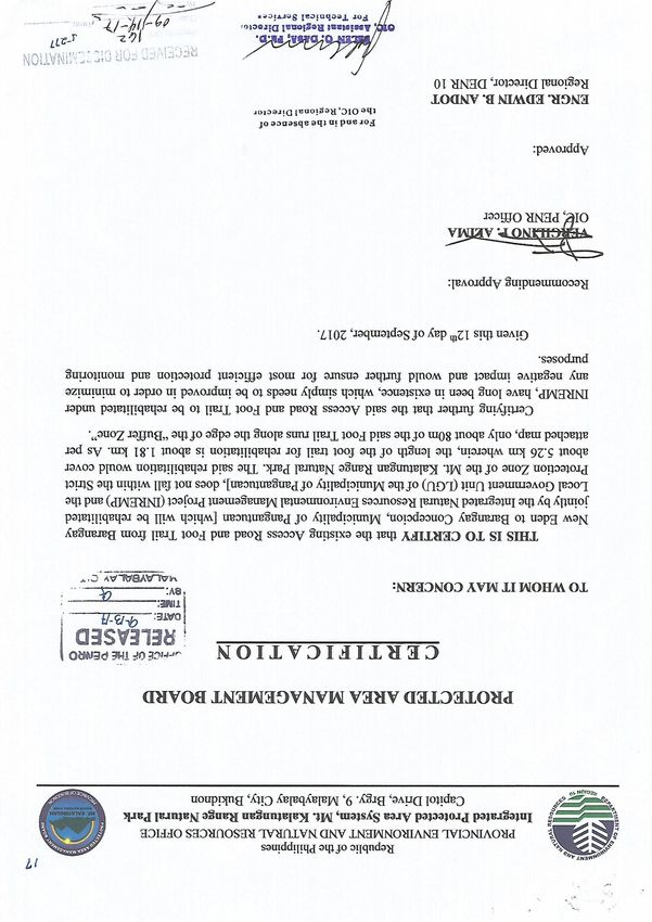
SPMU Sub-Project Management Unit
SPS Safeguard Policy Statement
SSS Social Safeguards Specialist
TA Technical Assistance
TDS Total Dissolved Solids
TOR Terms Of Reference
TSP Total Suspended Particulates
WMA Watershed Management Area
WMPCO Watershed Management And Project Coordination Offices
iii
WEIGHTS AND MEASURES

                                ˚C       –     degree centigrade
                                ha       –     hectare
                               km        –     kilometer
                                 m       –     meter
                             m asl       –     meter above sea level
                               mm        –     millimeter
                              mg/L       –     milligram per liter
                           mg/Nm3        –     milligram per normal cubic meter
                               ppt       –     parts per thousand
                           μg/Nm3        –     microgram per normal cubic meter
                            µS/cm        –     microSiemens/cm
                                %        –     percent

                                             NOTE
                   In this report, "$" refers to US dollars unless otherwise stated.

This initial environmental examination is a document of the borrower. The views expressed
herein do not necessarily represent those of ADB's Board of Directors, Management, or staff,
and may be preliminary in nature.

In preparing any country program or strategy, financing any project, or by making any
designation of or reference to a particular territory or geographic area in this document, the
Asian Development Bank does not intend to make any judgments as to the legal or other
status of any territory or area.

                                                                                            iv
TABLE OF CONTENTS

I.      EXECUTIVE SUMMARY ............................................................................................... 1

II.     POLICY, LEGAL, AND ADMINISTRATIVE FRAMEWORK........................................... 2
A.      Environmental Clearance Requirements.................................................................... 2
      1. Government Environmental Laws, Regulations and Guidelines .................................. 2
      2. ADB Environmental Assessment Requirements ......................................................... 5

III. DESCRIPTION OF THE PROJECT ............................................................................... 6
A. Overview ....................................................................................................................... 6
A. Project Location ........................................................................................................... 7
B. Project Rationale.......................................................................................................... 7
C. Project Development Plan ........................................................................................... 9
    1. Project Components ................................................................................................... 9
    2. Description of the Project Phases ............................................................................. 11
D. Manpower Requirements .......................................................................................... 11
E. Project Cost................................................................................................................ 12
F. Project Duration and Schedule ................................................................................. 13
IV. DESCRIPTION OF THE ENVIRONMENT .................................................................... 13
A. Elevation and Slope ................................................................................................... 14
B. Geology ...................................................................................................................... 15
C. Soil .............................................................................................................................. 16
E.      Land Classification ................................................................................................. 17
F. Land Cover and Land Use ......................................................................................... 17
G. Climate ........................................................................................................................ 21
    1. Base Climate ............................................................................................................ 21
    1. Climate scenario for Bukidnon Province in 2020 and 2050 ....................................... 21
I. Natural Hazards.......................................................................................................... 23
H. Biological Environment ............................................................................................. 24
    1. Flora and Fauna ....................................................................................................... 24
K. Socio-Economic Conditions .................................................................................... 26
    1. Population ................................................................................................................ 26
    2. Influence Area Population ........................................................................................ 27
    3. Poverty Threshold .................................................................................................... 28
    4. Indigenous Peoples .................................................................................................. 29
    5. Civil Society Organization ......................................................................................... 30
    6. Education ................................................................................................................. 30
    7. Health Services ........................................................................................................ 30
    8. Housing .................................................................................................................... 31
    9. Transportation and Road Networks .......................................................................... 31
    10.   Waterworks Facilities ............................................................................................ 32
    11.   Power ................................................................................................................... 33
    12.   Communication ..................................................................................................... 33
    13.   Tourism................................................................................................................. 34

V.  ANTICIPATED ENVIRONMENTAL IMPACTS AND MITIGATION MEASURES .......... 34
A.  Pre-Construction........................................................................................................ 36
  1. Confirmation of no required resettlement, relocations, and compensation ................ 36
  2. Identification and prioritization of road section where re-gravelling will be done........ 36
  3. Preparation of detailed engineering designs and programs of work .......................... 36
  4. Recruitment of workers ............................................................................................. 36
B. Construction .............................................................................................................. 36

                                                                                                                                       v
1. Construction materials acquisition, transport access, and storage system ................ 36
  2. Clearing and removal of obstructions ....................................................................... 37
  1. Soil erosion .............................................................................................................. 37
  2. Ground surface leveling and gravelling of existing road ............................................ 37
  3. Civil works ................................................................................................................ 37
  4. Implementation of noise and dust control measure ................................................... 38
  5. Dust and noise from borrow pits ............................................................................... 38
  6. Implementation of spoil management and control measure ...................................... 38
  7. Solid and liquid construction waste management system ......................................... 38
  8. Water quality ............................................................................................................ 38
  9. Construction drainage system .................................................................................. 39
  10.  Workers health, safety and hygiene ...................................................................... 39
  11.  Traffic safety and management ............................................................................. 39
  12.  Ecological environment (Flora and Fauna) ............................................................ 40
  13.  Damaged to properties ......................................................................................... 40
  14.  Concrete washout ................................................................................................. 40
  15.  Use of Hazardous Substances .............................................................................. 40
  16.  Public safety ......................................................................................................... 41
C. Operation and Maintenance (O&M) Phase ............................................................... 41
  1. Operation of upgraded access road.......................................................................... 41

VI. INFORMATION DISCLOSURE, CONSULTATION, AND PARTICIPATION ................ 41
A. Stakeholder Consultations ........................................................................................ 41
B. Information Disclosure .............................................................................................. 43

VII. GRIEVANCE REDRESS MECHANISM ....................................................................... 44

VIII. ENVIRONMENTAL MANAGEMENT PLAN ................................................................. 46
A. Implementation Arrangements ................................................................................. 46
B. Environmental Mitigation .......................................................................................... 47
C. Environmental Monitoring ......................................................................................... 56

IX. CONCLUSION AND RECOMMENDATION ................................................................. 59
A. Conclusion ................................................................................................................. 59
B. Recommendation ....................................................................................................... 60

                                                                                                                                 vi
LIST OF FIGURES

Figure 1: The Muleta River Watershed and the location of the Proposed RI Subproject ........ 8
Figure 2: Elevation and Slope of the Proposed Subproject ................................................. 15
Figure 3: Land Classification of the Pangantucan, Bukidnon ............................................... 19
Figure 4: Location of the Proposed Road and Foot Trail along the Buffer Zone .................. 20
Figure 5: Record of Tropical Cyclones that Passed through the Region Covering
          the Influence Watersheds during the Period 1948 - 2009 (PAGASA) .................. 22
Figure 6: Monthly rainfall based on CNCM3 model for 2020s and 2050s periods
          in Bukidnon Province .......................................................................................... 23
Figure 7: Photographs of Affected Vegetation of the Proposed Subproject ......................... 26
Figure 8: Historical Growth of Population ............................................................................ 27

LIST OF TABLES

Table 1: Summary List of ECP Types and ECA Categories .................................................. 3
Table 2: EIS and IEE Requirements for Road and Bridge Projects ....................................... 4
Table 3: Breakdown of Cost Estimates for the Road Rehabilitation Project ......................... 12
Table 4: Implementation Schedule ...................................................................................... 13
Table 5: Slope Range Classification.................................................................................... 14
Table 6: Soil Series Type within the Muleta Watershed....................................................... 16
Table 7: Land Area by Barangay per Land Classification .................................................... 18
Table 8: Land - Use by Municipality .................................................................................... 18
Table 9: Projected monthly rainfall based on CNCM3 model with A1b and A2
          scenarios for 2020s and 2050s periods in Bukidnon Province ............................. 22
Table 10: Change anomalies of rainfall in Bukidnon Province based on CNCM3 model ..... 23
Table 11: Total Annual Number of Typhoons in the Area .................................................... 24
Table 12: Summary of Flora and Fauna within the Watershed ........................................... 24
Table 13: Population of Barangay Concepcion and New Eden, Pangantucan ..................... 27
Table 14: Member of the Labor Force ................................................................................. 27
Table 15: Age and Sex Desegregation ................................................................................ 28
Table 16: Households with Income below Poverty Threshold.............................................. 29
Table 17: Composition on Ethnic Population ....................................................................... 29
Table 18: Population of IPs in the Influence Area ................................................................ 29
Table 19: Types of Education Facilities ............................................................................... 30
Table 20: School Facilities, Enrolment and Teachers .......................................................... 30
Table 21: Health Facility in Pangantucan Bukidnon ............................................................ 31
Table 22: Household Informal Settlers ................................................................................ 31
Table 23: Distance, Mode and Cost of Transportation......................................................... 32
Table 24: Number of Households Served by Water Systems .............................................. 33
Table 25: Number of Households Energized (Pangantucan) CY 2012-2016 ....................... 33
Table 26: Assessment of Potential Environmental Impacts ................................................. 34
Table 27: Summary of Stakeholder Consultation of the Road Access
          and Foot Trail Rehabilitation in Pangantucan ...................................................... 42
Table 28: Responsibilities for EMP Implementation ............................................................ 46
Table 29: Environmental Impact Mitigation Plan.................................................................. 47
Table 30: Environmental Monitoring Plan ............................................................................ 58

                                                                                                                         vii
LIST OF APPENDIXES

Appendix 1: A copy of the PAMB resolution ........................................................................ 61
Appendix 2: PTTAI PO resolution of support to the subproject ............................................ 62
Appendix 3: Brgy. Concepcion and Brgy. New Eden resolutions of support to
            the subproject ................................................................................................. 63
Appendix 4: Minutes of the public consultation .................................................................... 65
Appendix 5: Grievance Intake Form .................................................................................... 74

                                                                                                                           viii
I.     EXECUTIVE SUMMARY

1.     This Initial Environmental Examination has been prepared for the Rural Infrastructure
Rehabilitation of New-Eden – Concepcion Access Road and Foot Trails. This Sub-project is
the rehabilitation of the existing access road with an estimated length of 5.260 km, width of 4
m. The main proponent of the project is the Local Government Unit of Pangantucan, Bukidnon
assisted by Department of Environment and Natural Resources – Integrated Natural
Resources and Environmental Management Project. The project implementation will be co-
managed by the Municipal Planning and Development Coordinator and the Municipal
Engineer.

2.       The objective of the Rural Infrastructure – Rehabilitation of New-Eden – Concepcion
Access Road and Foot Trails is uplifting the quality of life of the people thru the provision of
all-year-round easy and affordable access thereby improving the prompt delivery of basic
services, increasing economic opportunities and conditions. The proposed access road and
foot trails will support the NRM project activities of the constituents.

3.      The Sub-project has been categorized by ADB as Environment Category B and this
IEE was prepared consistent with the environmental assessment requirements of ADB’s
Safeguard Policy Statement of 2009. The IEE was carried out through screening and analysis
of various environmental parameters, field investigations, stakeholder consultations, and
review of other road project reports in the Philippines. The IEE covers the general
environmental profile of LGU-Pangantucan rural infrastructure sub-project and includes an
assessment of the potential environmental impacts during different sub-project phases and
formulation of corresponding mitigation measures. The IEE was prepared by the LGU-
Pangantucan with the cooperation of RPCO, PMU, WMCO and POs.

4.      The total cost of the subproject is Nineteen Million Two Hundred Six Thousand
Seven Hundred Sixty Pesos and Sixty-nine centavos (PhP 19,206,760.69). The project
funding source is majority coming from the DENR - INREMP and LGU with a cost sharing of
80% and 20%, respectively. It will be assumed that the benefits of the subproject will be the
reduction of travel time by 15 minutes, transportation cost by 21.58%, increase number of trips
by 50% and availability of infrastructure support for NRM projects and other agricultural
livelihood projects of the community.

5.      Major land use along the road access and foot trails rehabilitation subproject is
agriculture which is part of production forest. The middle section of the proposed subproject
is located along the Mt. Kalatungan buffer zone.

6.      The IEE, based on the screening of baseline environment and review of proposed civil
works, has not identified any major environmental concerns due to proposed rehabilitation of
New-Eden – Concepcion Access Road and Foot Trails given that all the proposed civil works
are only asset preservation of existing roadway and are located within existing right of way.
There will only be localized short-term impacts during construction activities due to
implementation of civil works that will be addressed in the detailed design and through
implementation of the mitigation and monitoring measures specified in the environmental
management plan. The IEE process included stakeholder participation and consultation to
help LGUs achieve public acceptance of the Sub-project. A series of consultations with its two
influenced

                                                                                              1
7.     Barangays (Concepcion and New Eden) of the local government of Pangantucan
confirmed that the rehabilitation of New-Eden – Concepcion Access Road and Foot Trails is
essential for economic development.

8.     A grievance redress mechanism will be established by the LGU of Pangantucan prior
to commencement of site works to ensure that complaints of affected persons and other
stakeholders regarding the project’s environmental performance are promptly addressed.

9.      The IEE includes an environmental management plan which details the mitigation
measures, environmental monitoring activities, institutional responsibilities, and environmental
management capacity building. The LGU through its Municipal Planning and Development
Coordinator and the Municipal Engineer will ensure that relevant EMP provisions are included
in bid and contract documents for detailed design, project supervision and civil works. During
construction, they will closely conduct monitoring the contractor’s environmental performance
and over-all EMP implementation. Semi-annual environmental monitoring reports will be
submitted by LGU to ADB and such reports will be posted on ADB’s website for public
disclosure.

10.      The major positive impact of the project will be economic and better accessibility. The
sub-project will directly benefit people located within the two barangays providing improved
access and economic development. In relation to the National Greening Program, the
proposed road will traverse these NGP areas. The sub-project would also benefit the
environment in terms of reduced soil erosion and landslides through slope stabilization
measures and construction of retaining structures. Dust generation from the damaged roads
will be reduced by the improvement of pavement. Health risk to the roadside communities and
damage to the biological environment will be reduced due to pavement improvement and soil
erosion control measures.

11.    This Subproject will have overall beneficial impact and will have minor negative
impacts that will be carefully monitored and adequately mitigated through implementation of
the EMP.

              II.     POLICY, LEGAL, AND ADMINISTRATIVE FRAMEWORK

A.     Environmental Clearance Requirements

       1.       Government Environmental Laws, Regulations and Guidelines

12.      According to the EMB Memorandum Circular 005 - 2014, the environmental category
of a project is decided based on the type of the project (whether it falls into ‘Environmental
Critical Project’, ECP type), location of the project (whether it falls into ‘Environmental Critical
Areas’, ECA category), and size of the project. A summary list of ECPs and ECA categories
are presented in Table 1.

                                                                                                  2
Table 1: Summary List of ECP Types and ECA Categories
A. List of ECPs
As declared by Proclamation No. 2146 (1981)
1. Heavy Industries – Non-ferrous Metal Industries, Iron and Steel Mills, Petroleum and Petro-
chemical Industries including Oil and Gas, Smelting Plants
2. Resource Extractive Industries – Major Mining and Quarrying Projects, Forestry Projects
(logging, major wood processing projects, introduction of fauna (exotic animals) in public and
private forests, forest occupancy, extraction of mangrove products, grazing), Fishery Projects
(dikes for/ and fishpond development projects)
3. Infrastructure Projects – Major Dams, Major Power Plants (fossil-fueled, nuclear fueled,
hydroelectric or geothermal), Major Reclamation Projects, Major Roads and Bridges
As declared by Proclamation No. 803 (1996)
4. All golf course projects
B. List of ECA Categories - As declared by Proclamation No. 2146 (1981)
1. All areas declared by law as national parks, watershed reserves, wildlife preserves, sanctuaries
2. Areas set aside as aesthetic potential tourist spots
3. Areas which constitute the habitat of any endangered or threatened species of Philippine wildlife
(flora and fauna)
4. Areas of unique historic, archaeological, or scientific interests
5. Areas which are traditionally occupied by cultural communities or tribes
6. Areas frequently visited and/or hard-hit by natural calamities (geologic hazards, floods, typhoons,
volcanic activity, etc.)
7. Areas with critical slopes
8. Areas classified as prime agricultural lands
9. Recharged areas of aquifers
10. Water bodies characterized by one or any combination of the following conditions: tapped for
domestic purposes; within the controlled and/or protected areas declared by appropriate
authorities; which support wildlife and fishery activities
11. Mangrove areas characterized by one or any combination of the following conditions: with
primary pristine and dense young growth; adjoining mouth of major river systems; near or
adjacent to traditional productive fry or fishing grounds; areas which act as natural buffers
against shore erosion, strong winds and storm floods; areas on which people are dependent for
their livelihood.
12. Coral reefs characterized by one or any combination of the following conditions: With 50% and
above live coralline cover; Spawning and nursery grounds for fish; Act as natural breakwater of
coastlines
13. Based on their type, size and location the projects have been classified into 3 major
groups:
• Group I (ECPs): ECPs in either ECAs or NECAs – Environmentally Critical Projects in
either Environmentally Critical Areas or Non-Environmentally Critical Areas. These
projects require the proponent to submit ‘Environmental Impact Statement’ report to
secure ‘Environmental Compliance Certificate’ from DENR’s Environment
Management Bureau (EMB). Table 2 gives the size of the road and bridge projects
that fall in to Group 1.
• Group II (NECPs): NECPS in ECAs – None Environmentally Critical Projects in
Environmentally Critical Areas. These projects require proponent to submit either
‘Initial Environmental Examination’ Report or ‘Project Description Report ‘ based on
the size of the project (see Table 2) to secure either ECC or ‘Certificate of Non
Coverage’.
• Group III (Non Covered Projects): NECPs in NECS – Non Environmentally Critical
Projects in Non Environmentally Critical Areas. PDR required to be submitted for
Enhancement Mitigation Projects for confirmation of benign nature of proposed
3activity, and CNC is required to be secured. All other projects shall be at the option of
the proponent to prepare a PDR as a basis for CNC, should the proponent opt to
secure one.
Table 2: EIS and IEE Requirements for Road and Bridge Projects
Not covered
Covered (Required to secure ECC)
(may secure CNC)
Projects within the Project size
CATEGORY A: ECP CATEGORY B: Non-ECP CATEGORY D
INREMP Menu of parameters /
Project
Subprojects Remarks
EIS EIS IEE Checklist Description (Part I
only)
3.1Dams, Water
Supply and
Flood Control
Project
>5 hectares
3.1.1DAMS
but Reservoir
(including those for
5 million m3 or/and water
and hydropower ≤5 million m3
but storage
projects) including
300 but
hectares
projects (distribution NONE 50%
>50%
increase in
increase in
capacity (or in
capacity (or
terms of
in terms of
length/width) >50% increase in
length/width)
3.4.2 Roads, AND capacity (or in
AND
widening, >2km but terms of
NONE ≥20km,
rehabilitation and/or 50m but
≥10km length for
elevated roads), newNot covered
Covered (Required to secure ECC)
(may secure CNC)
Projects within the Project size
CATEGORY A: ECP CATEGORY B: Non-ECP CATEGORY D
INREMP Menu of parameters /
Project
Subprojects Remarks
EIS EIS IEE Checklist Description (Part I
only)
3.6 Buildings
including
Housing, Storage
facilities and
Other Structures
Total/gross
floor area
3.6.2 Storage
>1 hectare including
facilities with no
NONE ≥ 5 hectare but ≤ 1 hectare parking,
hazardous or toxic16. According to Philippines environmental guidelines, the Project or Sub-project can be
considered as either under Group II or III while ADB has categorized the Project as
environment Category B. Hence, this IEE has been prepared to meet the requirements of both
the ADB and the government. Upon ADB’s receipt of the final IEE from the proponent, this will
be publicly disclosed through posting on ADB’s website.
III. DESCRIPTION OF THE PROJECT
A. Overview
17. Barangay New Eden and Concepcion are adjoining barangays along the foot of Mount
Kalatungan and head water of the Muleta River Watershed. These are rural and farming
barangays. The New Eden-Concepcion road is an existing access road that traverses along
these two (2) barangays leading to Poblacion.
18. Rehabilitation of New Eden-Concepcion access road and foot trail will greatly improve
the accessibility within these two (2) barangays. It could also provide alternative route to
farmers in marketing their products to other barangays or bringing those products to
Poblacion. It will also ensure safety of the people due to the ease of access for responding
personnel in case of emergencies. As entry point to Mt. Kalatungan climbers, this particular
access road and foot trail is also very useful for eco-tourism endeavours, as part of the Eco-
tourism program of the municipality (Mt. Kalatungan being Ancestral Domain of the Manobo
and Talaandig Tribe), there is a partnership between the LGU and various Indigenous Peoples
(IPs) in the area, as provided for by Ordinance No. 16, series of 2014. Particularly, the IPs
serve as tourist guides, and porters, earning an income of 350 and 400 per day, respectively
(ratio of 1:10 guide:tourist).
19. To boost economic activity and improve social and infrastructure services in the rural
barangays, particularly for Concepcion and New Eden, and the municipality as a whole, the
rehabilitation of New Eden-Conception access road and foot trail is deemed timely and
necessary to generally lessen the vulnerability of the barangay residents during emergency
situations.
20. The Rehabilitation of New-Eden – Concepcion Access Road and Foot Trails is the only
existing road directly linking the Barangay New-Eden and Concepcion. Currently, residents
from Barangay Concepcion will pass through first barangay Poblacion before reaching
Barangay New Eden and it will take them a travel distance of 12.5 km. While using the
proposed road section that is directly connecting Barangay Concepcion and Barangay New
Eden only take 5.26 km which have a difference of 7.24 km travel distance.
21. Among all road networks of the municipality, this said road section has the worst
condition in terms of its physical condition and accessibility compared to other road section
within the municipality. The two (2) barangays within the influence area of this road section
have large volume of agricultural products such as high value crops and vegetables. To
provide ease in transporting these said agricultural products to the market, this road section
needs to be given due attention, consideration and priority.
6A. Project Location
22. The Municipality of Pangantucan is situated along the southwestern border of the
province of Bukidnon. It lies within 124° 40’ to 124° 50’ east longitude and 7° 35’ to 7° 55’
north latitude, bounded on the north by the Municipalities of Valencia and Talakag, on the east
by the Municipalities of Maramag, Don Carlos and Kadingilan, on the west by the Municipality
of Kalilangan, and on the south by Province of North Cotabato. It is approximately 75 km
southwest of Malaybalay City, the capital of Bukidnon Province, and is about 166 km southeast
of Cagayan de Oro City, the capital of Region 10 (Northern Mindanao). It is composed of 19
barangays, all of which are accessible all year round.
23. Pangantucan has a total land area of 485.84 sq km (48,584 ha), of which, about 52%
is currently classified as forestland; the remaining 48% are Alienable and Disposable (A and
D) lands.
24. The Municipality’s terrain is characterized by slightly undulating and rolling upland
areas, about 62% of which has rolling or hilly terrain within 18% to 50% slope range. Only
about 14% of the land area is suitable for agricultural production. On the northwest portion of
the municipality is Mt. Kalatungan, the second highest peak in the province with an elevation
of 2,824 m asl. Its mountain ranges occupy about 21% of the municipality’s total land area.
B. Project Rationale
25. The Muleta River Watershed is found in the southern portion of the province covering
the municipalities of Pangantucan, Don Carlos, Kitaotao, Dangcagan, Kibawe, Kadingilan and
Damulog (Figure 1). It is one of the important tributaries of the Pulangi River, which flows
southward. It will join the Pulangi River in the boundary of Bukidnon and Cotabato province.
The municipality has many water sources with their headwaters from Mt. Kalatungan. Water
resources along Mt. Kalatungan vicinity are of critical importance to both natural ecosystem
and human development. It is essential for agriculture, industry, and human existence. The
healthy aquatic ecosystem is dependent on the physicochemical and biological
characteristics. The quality of water in any ecosystem provides significant information about
the available resources that support life in that ecosystem.
26. Barangay Concepcion and New Eden are located at the southern foot of the Mt.
Kalatungan National Range Park and head water of the Muleta River watershed. The influence
area of the proposed RI subproject has farmlands that are cultivated for agricultural crops.
Thus, the rehabilitation of the road section will be beneficial to the farmers, and will be easier
for them to transport their farm products.
27. Additionally, DENR programs such as INREMP NRM subprojects, and NGP, are
located within the influence area; and this proposed rural infrastructure will be a support facility
to such DENR subprojects. The Indigenous People Organization (IPO), which is the Portulin
Talaanding Tribal Association Inc. (PTTAI), is a recipient of several DENR programs and are
also farmers who are actively engaged in farming within the area.
28. Overall, there is a great need to rehabilitate the said road section, in order that the
travel time going to the farms will be shortened. Constituents will be encouraged in farming
since it will be easier for them to transport their farm products to the market, at a lesser
transport cost.
7Figure 1: The Muleta River Watershed and the location of the Proposed RI Subproject
8C. Project Development Plan
1. Project Components
29. The scope of works of the road rehabilitation subprojects are the following:
Road graveling
Road concreting
Provision of stone masonry line canal
Provision of RCPCdrains
Provision of riprap stone masonry soil stabilization
Concrete slab for foot trail
30. The 2,850 meters surface gravelling in Barangay New Eden will start from Sta. 00+000
to station 0+600 and Station 1+200 to Station 3+000. The average thickness of surface
aggregate to be placed shall be 0.20m on the existing 4 meter-wide barangay road. Placing
of surface aggregates shall conform to the requirement of the road during the construction
date to achieve standard road level and stability.
31. The station 0+600 to station 1+200 requires road concrete pavement because it is mostly
rolling with some critical sections. The average thickness of surface to be placed shall be 6
inches or 150mm on a 4 meter-wide barangay road and 600 meters.
32. Provision of stone masonry line canal from station 0+00 to station 0+600, station 0+600
to station 1+200, station 1+700 to 2+000, station 2+100 to station 3+050, station 3+150 to
3+450.
33. The installation of RCPC Cross Drainage at station 3+580 t0 3+600, station3+660 to
3+675, station 3+700 to 3+720 will be made-up of Reinforced Concrete (RC) and stone
masonry.
34. Provision of riprap stone masonry is necessary for slope protection in the site
particularly station 3+580 to station 3+600, station 3+660 to station 3+675, and station 3+700
to 3+720.
35. Part of the scope of works is the concrete slab for the foot trail with a total length of
1,810 meters from station 3+460 to station 5+260.
36. The following are the major technical specifications of the project:
Embankment (Item 104)
This Item shall consist of the construction of embankment in accordance with the
Specification and in conformity with the lines, grades and dimensions shown on the
Plans or established by the Engineer.
Structure Excavation (Item 103)
This Item shall consist of the necessary excavation for foundation of culverts, cross
drains, and other structures not otherwise provided for in the specifications. It shall
also include the furnishing and placing of approved foundation fill material to replace
unsuitable material encountered below the foundation elevation of structures.
9Sub-grade Preparation (Item 105)
This Item shall consist of the preparation of the subgrade for the support of overlying
structural layers. It shall extend to the full width of the roadway. Subgrade preparation
shall not be done unless the Contractor is able to start immediately the construction of
the pavement structure.
Sub-base Course (Item 200)
This item shall consist of furnishing, placing and compacting an aggregate sub-base
course on a prepared sub-grade in accordance with the Specification and the lines,
grades and cross-sections shown on the Plans, or as directed by the Engineer.
Aggregate Base Course (Item 201)
This Item shall consist of furnishing, placing and compacting an aggregate base course
on a prepared sub-grade in accordance with this Specification and the lines, grades,
thickness and typical cross-sections shown on the Plans. Aggregate for base course
shall consist of hard, durable particles or fragments of crushed stone, crushed slag or
crushed or natural gravel and filler of natural or crushed sand or other finely divided
mineral matter.
The composite material shall be free from vegetable matter and lumps or balls of clay,
and shall be of such nature that it can be compacted readily to form a firm, stable base.
Surface Course (Item 300)
This Item shall consist of furnishing, placing and compacting an aggregate surface
course on a prepared base coarse in accordance with the Specification and the lines,
grades, thickness and typical cross-sections shown on the Plans, or as established by
the Engineer.
Portland Cement Concrete Pavement (Item 311)
This Item shall consist of pavement of Portland Cement Concrete, with or without
reinforcement, constructed on the prepared base in accordance with this Specification
and in conformity with lines, grades, thickness and typical cross-section shown on the
Plans.
Pipe Culvert (610mm) (Item 500)
This item shall consist of the construction or reconstruction of pipe culverts and storm
drains, hereinafter referred to as “conduit” in accordance with this Specification and in
conformity with the lines and grades shown on the Plans or as established by the
Engineer.
Stone Masonry (Item 506)
This item shall consist of the construction and establishment of drainage as grouted
riprap side ditches in accordance with this Specification and in conformity with the
lines and grades shown on the Plans or as established by the Engineer.
102. Description of the Project Phases
a. Pre-Construction Phase/Pre-Development Phase
37. This phase would involve the social preparation (to include organizational
strengthening, planning, identification and prioritization of community needs) of the community
for the entry of the project to the site, conduct of pre-engineering activities covering detailed
survey works to determine alignment of roads and canal systems, preparation of the detailed
engineering plans and programs of work, ROW negotiation, recruitment of work force and
initial sourcing and procurement of construction materials. These activities will be conducted
by the proponent technical staff, partner line agencies, NGO service providers, community
beneficiaries especially the Indigenous People and contractors.
b. Construction/Development Phase
38. This phase would involve the mobilization of construction equipment, construction
workers and materials to the specific subproject site after which the longer period of actual
construction work will commence. The construction phase will end up with the demobilization
of construction equipment, workers and other construction paraphernalia from the construction
site. Majority of these activities will be undertaken by the contractor and community
beneficiaries under the close supervision of the SPMU most especially by the municipal
Engineering Unit.
c. Operation Phase and Maintenance Phase
39. This phase involves the actual maintenance of the rehabilitated access road during its
expected economic life. Monitoring tools and parameters will be set forth in the MOA that the
LGU and DENR will sign to ensure sustainability of the constructed facility. The specific
monitoring items and parameters, location and frequency, monitoring responsibilities and
sources of budget are presented in the EIAMMP as attached.
d. Abandonment Phase
40. This phase is included in the project demobilization. The proponent does not intend to
abandon any facilities and unserviceable equipment used during construction. The project
location will not be abandoned in disorderly condition but instead restored for functional use.
Following the completion of the construction, the proponent will dismantle temporary shelters
and the construction yard including unserviceable vehicles and equipment.
41. Wastes arising from the abandonment are expected to be minimal. These wastes could
include small volumes of left over sand and gravel, re-bars and other construction materials
and lumber.
D. Manpower Requirements
42. Construction activities will require hiring of skilled and unskilled manpower. It is
assumed that some skilled, semi-skilled and unskilled manpower will be available in the area.
Skilled manpower not available in the locality may be sourced from other nearby localities.
Technical manpower will be a complementation of specialists to be provided by locally known
engineering firms.
1143. During the construction phase, a workforce consisting of contractual and regular
laborers will be employed to carry out the construction of the proposed project.
44. The Contractor shall employ qualified and sufficient staff to carry out inspections,
testing and monitoring for the project.
E. Project Cost
45. The propose RI project has a total cost of Nineteen Million Two Hundred Six
Thousand Seven Hundred Sixty Pesos and Sixty-Nine centavos (PhP 19,206,760.69).
The INREMP grant will be Fifteen Million Three Hundred Sixty-Five Thousand Four Hundred-
Eight Pesos and Seventy-three Centavos (PhP 15,365,408.73) and the LGU counterpart will
be Three Million Eight Hundred Forty-One Thousand Three Hundred Fifty-two Pesos and
Eighteen centavos (PhP 3,841,352.18). The LGU equity will be taken from its 20%
development fund stipulated in its annual budget.
46. The estimated cost of the proposed subproject is PhP 19,206,522.69. Breakdown of
cost estimates is presented in (Table 3).
Table 3: Breakdown of Cost Estimates for the Road Rehabilitation Project
Project Title: Rehabilitation of New Eden- Concepcion Access Road and Foot Trail
Category Rural Access (Road Rehabilitation/Improvement)
Physical Target kms.
Brgy/Mun/Province Brgy. New Eden / Pangantucan/ Bukidnon
Total Project Cost
Project Description: Implementation Mode By Contract
Rehabilitation of New Eden- Project Duration calendar days
Equipment Needed Dozer/Grader/R.
Technical Personnel Civil
Item No. Scope of Work % Weight Quantity Unit Unit Cost Total
A. EARTHWORKS
102 Excavation 0.05 8759.358 cu.m. 152.98 804,686.78
104 Embankment 0.01 1643.717 cu.m. 18.05 94,968.40
103 Structure Excavation 1.39% 2,150.30 cu.m. 61.25 215,030.40
105 Subgrade Preparation 1.22% 13,200.00 sq.m. 14.32 189,077.04
B. SURFACE COURSE
200 Aggregate Subbase Course 23.61% 2,277.00 cu.m. 1,602.18 3,648,160.12
300 Aggregate Surface Course 16.75% 1,863.00 cu.m. 1,201.56 2,588,235.00
C. SURFACE COURSE
311.A PCCP 16.75% 360.00 cu.m. 6,218.07 2,588,235.00
311.B Fabrication of Concrete Slab 3.06% 9,701.00 kgs 63.95 473,406.00
311.C Installation of Concrete Slab 5.78% 3,110.00 pcs 287.12 892,930.67
E. DRAINAGE & SLOPE PROTECTION STRUCTURE
500(1) RCPC, 910mm ø 0.92% 28.00 lin.m. 5,094.27 142,711.88
505(5) Grouted Riprap 2.16% 187.00 cu.m. 2,333.88 333,055.00
Canal Lining 22.14% 1,575.00 cu.m. 2,845.55 3,420,137.90
506 Headwalls 0.38% 978.00 cu.m. 3,492.09 58,627.96
Total Project Cost 100.00% 15,449,262.14
SOURCE OF FUND
Breakdown of Estimated Project Cost Total Cost
INREMP ( 80% ) LGU ( 20% )
A. Direct Cost 15,449,262.14
B. Indirect Cost 3,757,260.55
OCM 9% OF Direct Cost 463,477.86
Contractor's Profit 8% OF Direct Cost 1,235,940.97
VAT 12% ( DC + OCM +CP ) 2,057,841.72
C. Project Cost (Total A + B) 15,365,218.16 3,841,304.54 19,206,522.69
Say ,Estimated Project Cost (EPC)
D. PERCENTAGE
47. The source of fund for the project will come from National Government and Local
Government Unit with a cost sharing of 80% and 20%, respectively. The total project costs of
PhP 19,206,522.69 will be utilized for direct cost (materials, equipment and labor) with the
amount of PhP 15,449.262.14, indirect cost (contractor’s’ profit, OCM and VAT) of PhP
3,757,260.55.
1248. The Local Government of Pangantucan has the capacity to provide counterpart for
INREMP Rural Infrastructure. During the budgeting for 2016, the LGU has allocated a total of
Php 3,841,352.18 from its Local Development Fund.
49. Aside from the equity counterpart provided by the LGU Pangantucan for the subproject,
they also allocated some amount intended for the preparation of the project such as seminars,
preparation of feasibility study (or subproject proposal document) and detailed engineering,
survey of the project site and some evaluation by the personnel from different sectors who will
be involved in the implementation of the subproject.
F. Project Duration and Schedule
50. The timetable for the subproject implementation is expected to reach a total of 365
calendar days. It is projected that the preparation of Detail Engineering Design (DED) will also
be completed by end of December 2017. After the DED is translated into standard bidding
document (SBD), procurement activities for civil works is projected to proceed, starting April
2018 through national competitive bidding (NCB). Advertisement, opening of bids, bid
evaluation and award of contract is expected to take at least 28 days.
51. Rehabilitation period is estimated to cover 365 calendar days. Physical completion,
including the completion of documentary requirements, is expected by end of January 2019.
The matrix below shows the major stages of implementation and respective timeline (Table
4).
Table 4: Implementation Schedule
2017 2018 2019
RI Subproject Milestones53. Barangays Concepcion and New Eden are located at the Southern foot of the
Kalatungan National Range Park and head water of the Muleta River watershed.
54. Barangay Concepcion’s land area is about 2,719 hectares. The types of soil is from
sandy to clay. It is bounded by Talakag in the North, Poblacion and Adtuyon in the South,
New Eden in the East, and Mendis in the West.
55. Barangay New Eden has a total land area of about 1,015 hectares. Based on soil
texture distribution of the barangay, about 10% are clay, 44% are loam, 5% are sandy, 19%
are clay loam and 22% are sandy loam. The barangay is about 7 km from the central Poblacion
of Pangantucan. It is bounded in the north by the municipality of Talakag, in the south by
barangay Adtuyon, in the east by barangay Portulin, and in the west by barangay Concepcion.
A. Elevation and Slope
56. The municipality of Pangantucan has about 21% are mountain ranges, while about
61% are hilly or rolling terrain. The remaining area is relatively flat, fit for agricultural
production. The elevation of Pangantucan ranges from 252 m to 2,824 m above sea level (m
asl) with the highest point at the peak of Mt. Kalatungan. Around 40% of the area has an
altitude of 1,000 m especially, within the Mt. Kalatungan range. The rest of the area lies within
the 252 to 1,000-meter altitude.
57. The terrain of Pangantucan is characterized by slightly undulating and rolling upland
areas (Table 5). Only 4.81% of the total area is relatively flat, with slope-range of 0 to 3%. A
large portion of the land, however, has slopes ranging from 18% to 50% and above.
Table 5: Slope Range Classification
Slope Range (%) Area (ha) Percent of Total (%)
0-3 2,337.5 4.8
3-8 5,912.5 12.2
8-18 5,792.5 11.9
18-36 12,284.1 25.3
36-50 10,066.3 20.7
50 above 12,191.4 25.1
Total 48,584.2 100
Source: MPDO (2015)
58. In particular, the proposed subproject has an elevation ranging from 1,005 to 1,243 m
asl with an average slope of 9.6%. Other details are shown in Figure 2.
14Figure 2: Elevation and Slope of the Proposed Subproject
B. Geology
59. Based on the Geologic Map of the Philippines and the Geologic Report of
Pangantucan, Bukidnon prepared by Francisco et al. (1952), the rocks underlying the area
arranged in their order of decreasing age are the limestone, Pangantucan volcanic and the
clastics.
60. The limestone is believed to be in the upper Mio-Pliocene age and considered as the
oldest in the stratigraphic sequence. It is coralline and in places highly fossiliferous. It is well
bedded, hard and locally marl and thin interbeds of calcareous sandstone and shale are
observed. Sinkholes are common.
61. The Pangatucan volcanic, a terminology proposed by Francisco (1952) to indicate the
type of locality where the volcanic were encountered is porphyritic and in part, amygdaloidal.
The penocrysts consists of feldspar, olivine and in minor amounts, of stubby crystals of
pyroxene. The groundmass consists of fluidal microlites of feldspar mixed with magnesite and
granule of pyroxene with intercalated glass occasionally chlorite. Amygdulesare filled with
chlorite. This rock is exposed over a wide area though partly covered with either thin alluvial
or residual mantle mostly on the lower slopes.
62. The limestone and the widespread volcanic are uncomfortably overlain by the clastics
composed essentially of sandstone and mudstone with interbeds of diatomite lenses. The
sandstone is made up mostly of quartz grains small amount of minerals, possibly horrnblende,
augite and magnetite. The mudstone is light gray carbonaceous and some are mixed with
diatomite.
15C. Soil
63. Generally, the soil of Muleta Watershed consists mostly of Adtuyon clay Kidapawan
clay, Macolod clay and mountain soil (Table 6). Adtuyon clay has the largest area coverage.
Its coverage encompasses middle portion of the watershed where six municipalities are
situated. On the other hand, the sub-watersheds are characterized by Kidapawan clay except
for Apulang River in southwestern portion where the soil type is Macolod clay.
64. All these series were developed from parent materials that originated from the volcanic
lava. These types of soils are called zonal soils owing to the combined effects of climate and
vegetation on various rocks which have lived in a well-drained position long enough for
dynamic equilibrium to be reached between the delay and accumulation of organic matters
and between the rates of erosion and rock weathering.
Table 6: Soil Series Type within the Muleta Watershed
Soil Series Type Total
Adtuyan clay 17,664
Faraon clay 1,689
Kidapawan clay; Kidapawan clay loam 25,218
La Castellana clay loam 5,850
Macolod clay 21,153
Mountain soil (undifferentiated) 4,740
Tacloban clay 1,522
Grand Total 77,837
Source: Bureau of Soil and Water Management, 1996
D. Water quality
65. The proposed rural infrastructure subproject is the rehabilitation of New Eden –
Concepcion access road and foot trail which is located at Barangay New Eden and Sitio
Tagolilong, Barangay Concepcion, Municipality of Pangantucan, Province of Bukidnon. The
Barangay is one of the beneficiaries of the Integrated Natural Resources and Environmental
Management Project for the municipality since the Muleta River traverses the barangay
boundary. The proposed access road and foot trail will link to municipal watershed subprojects
since the RI subproject will start at the municipal boundary of Maramag, Don Carlos,
Kadingilan and Valencia which is the Muleta River.
66. In addition, the proposed access road subproject is passing across the Pulangi river
which is one of the tributaries of the Muleta Watershed. The Pulangi river has still no water
classification pursuant to DAO No. 34, Series of 1990 and DENR Memorandum Circular No.
09, Series of 2001. In the absence of water classification and in accordance with the Manual
of Procedure for Water Classification, the Pulangi river is assumed to be a Class A waters
since most of the upstream stations are under this classification. A “Class A” waters intended
beneficial use is public water supply class which is usually sources of water supply that will
require complete treatment (coagulation, sedimentation, filtration, and disinfection) in order to
meet the National Standards for Drinking Water.
67. The Watershed Management Plan (2015) described the water quality conditions of the
Muleta Watershed which was based on DAO 34-1990. The description is only limited to the
following parameters:
The Muleta Watershed mean temperature is 27°C which indicates that the water
in the watershed is within the normal range for surface water.
16 Average pH value of 8.4 taken from different monitoring points showed that the
water quality of Muleta watershed conformed to the set standard (6.5 – 8.5) as
pH is an important limiting chemical for aquatic life.
Biochemical Oxygen Demand (BOD) in Muleta watershed has an average value
of 1 mg/L and still within the set standard (5 mg/L), which means minimum
degree of pollution strength of domestic and industrial wastes or has low in
purification capacities of bodies of waters in receiving organic wastes.
Dissolved Oxygen (DO) levels range from 5.5 to 7.7 mg/L - ) which is still above
the minimum set standard for Class A water (minimum of 5 mg/L.
Phosphate level of the Muleta Watershed is about 0.30 mg/L which is above the
set standard (0.1 mg/L).
The fecal coliform based on the existing monitoring station in the Muleta watershed
is 780 MPN/100 mL which is higher than the set minimum standard of 100
MPN/100 mL.
E. Land Classification
68. Pangantucan has a land area of about 48,584 ha, which is the 9th largest among the
20 municipalities of Bukidnon and two (2) cities of the province. Of the total land area, about
53% or about 257.57 ha is currently classified as forestland, while about 47% or 228.27 ha is
A and D lands.
69. About 29 % of the 53 % of forestland, is a production area, where DENR subprojects
are located, such as; National Resources Management (NRM), Reforestation, and National
Greening Program (NGP), where the communities are the direct beneficiaries.
70. Barangay Concepcion has a total land area of about 2,673 ha, and about 97% or about
2,598 ha is classified as forestland, and about 3% or 75 ha is classifies as A and D (Table 7).
Barangay New Eden has a total land area of about 947 ha, 60% or 567 ha is classified as
forestland, and about 40% or about 380 ha is classified as A and D. Table 2 shows the land
area by barangay per classification.
71. It must be noted that the proposed road access rehabilitation in Pangantucan is within
the public land as shown in Figure 3. In addition, the proposed subproject does not fall within
the Protected Area or Special Area for Protecting Biodiversity of the Mt. Kalatungan Range
Natural Park. The subproject covers about 5.0 km, wherein the length of the foot trail for
proposed rehabilitation is only 1.81 km. As shown in Figure 4, only about 80 m of the said foot
trail runs along the edge of the Buffer Zone. Hence, the LGU of Pangantucan has requested
a certificate to the Protected Area Management Board of the DENR Region 10 that the access
road and foot trail to be rehabilitated under INREMP, have long been in existence and needs
to be improved for efficient protection and monitoring purposes (Appendix 1).
F. Land Cover and Land Use
72. Table 8 shows the distribution of major land use by municipality within the watershed.
In terms of annual crops, the Don Carlos has the biggest area coverage (5,023 ha) while
Damulog has the smallest area (864 ha). Closed forests are locally found in Pangantucan,
Valencia and Talakag.
17You can also read