Markfield Parish Neighbourhood Plan 2020-2039 - 'MADE' VERSION 2021 - Hinckley ...
←
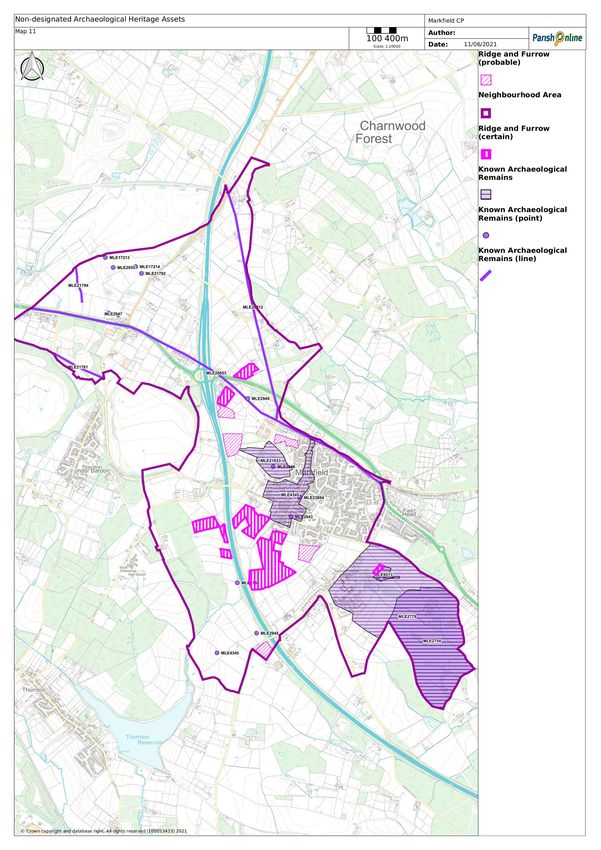
→
Page content transcription
If your browser does not render page correctly, please read the page content below
2021

Markfield Parish
Neighbourhood Plan
2020-2039

‘MADE’ VERSION
Markfield Parish Neighbourhood Plan:
‘Made’ Version

Contents
1.     Introduction ....................................................................................... 1
     Neighbourhood Plans ................................................................................ 1
     The Markfield Neighbourhood Area ............................................................... 1
     Basic Conditions...................................................................................... 2
       National Planning Policy Framework ........................................................... 2
       Hinckley and Bosworth Local Plan .............................................................. 2
     Excluded Development.............................................................................. 5
     How the Plan has been prepared .................................................................. 5
2.     Markfield Profile ................................................................................. 8
3.     Sustainable Development and Vision ......................................................... 9
     Sustainable Development ........................................................................... 9
     Vision .................................................................................................. 9
4.     Environment and Heritage .................................................................... 11
     Countryside .......................................................................................... 11
     Charnwood Forest Regional Park ................................................................. 14
       Area 6: Thringstone/Markfield Quarries and Settlement ................................... 14
       Area 2: Ulverscroft Wooded Valley ............................................................ 16
       Area 10: Groby/Ratby Wooded Farmland .................................................... 16
       Area 11: Thornton Plantation Farmlands ..................................................... 16
     National Forest ...................................................................................... 17
     Green Infrastructure ............................................................................... 17
     Biodiversity .......................................................................................... 21
       Billa Barra Hill Local Nature Reserve.......................................................... 21
       Hill Hole Quarry Nature Reserve ............................................................... 22
       Altar Stones Nature Reserve .................................................................... 26
     Trees.................................................................................................. 27
     Local Green Spaces ................................................................................. 28
     Climate Change ..................................................................................... 30
       Renewable Energy ............................................................................... 31
       Energy Efficiency Requirements ............................................................... 32
       Electric Vehicle Chargepoints .................................................................. 32
       Flood Risk ......................................................................................... 34
     Heritage .............................................................................................. 35
       History ............................................................................................. 35
       Designated Heritage Assets ..................................................................... 36

                                                        i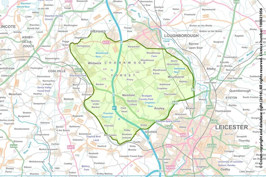
Markfield Parish Neighbourhood Plan:
‘Made’ Version

       Non-Designated Features of Local Heritage Interest ....................................... 40
     Design ................................................................................................ 44
       Traditional Building Styles ...................................................................... 45
5.     Facilities and Services ......................................................................... 47
     Education ............................................................................................ 47
       Mercenfeld Primary School ..................................................................... 47
       Markfield Institute of Higher Education ...................................................... 48
     Markfield Medical Centre .......................................................................... 49
     Shopping ............................................................................................. 51
     Markfield Community Library ..................................................................... 52
     Sport and Recreation ............................................................................... 52
       Markfield Community and Sports Centre ..................................................... 52
       Jubilee Playing Fields ........................................................................... 53
       Open Space and Recreation Study ............................................................. 54
     Community Meeting Places ........................................................................ 54
       Copt Oak Memorial Hall ......................................................................... 54
       Congregational Church Hall..................................................................... 55
       Methodist Church Hall ........................................................................... 55
     Hill Hole Quarry Allotments ....................................................................... 55
     Cemetery ............................................................................................ 55
     Mobile Network ..................................................................................... 56
     Superfast Broadband ............................................................................... 56
     Infrastructure ....................................................................................... 57
6.     Housing ............................................................................................ 59
     Hinckley and Bosworth Local Plan................................................................ 59
     Housing Provision ................................................................................... 59
     Housing Allocation .................................................................................. 60
       Land South London Road, Markfield ........................................................... 62
     Windfall Housing Development ................................................................... 64
     Meeting Local Housing Needs ..................................................................... 64
       Housing needs of older people ................................................................. 65
       Self-Build and Custom Housebuilding ......................................................... 68
       Affordable Housing............................................................................... 68
       Whitegate Stables Caravan Park ............................................................... 70
7.     Business and Employment ..................................................................... 71
     Economic Activity................................................................................... 71

                                                       ii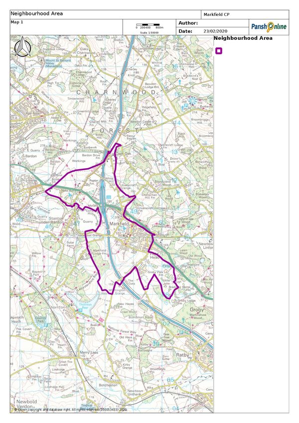
Markfield Parish Neighbourhood Plan:
‘Made’ Version

  Business .............................................................................................. 71
     Employment Land ................................................................................ 71
     Markfield Industrial Estate ...................................................................... 72
     Brownfield Land .................................................................................. 73
     Business Conversion of Rural Buildings ........................................................ 75
     Business Expansion ............................................................................... 75
     Minerals............................................................................................ 76
     Home Working .................................................................................... 78
Appendix 1: Local Green Space: Summary of Reasons for Designation .................... 79
Appendix 2: Traffic and Transport ................................................................ 80
  Road Network ....................................................................................... 80
     M1 Junction 22 ................................................................................... 80
     A511 Growth Corridor Scheme ................................................................. 80
     Local Roads ....................................................................................... 81
     Noise and Air Quality ............................................................................ 85
  Walking ............................................................................................... 86
     Pavements ........................................................................................ 86
     Footpaths and bridleways ....................................................................... 86
  Cycling ............................................................................................... 88
  Bus Services ......................................................................................... 88
Policies Map (Parish) ................................................................................ 90
Policies Map (Village) ............................................................................... 91
........................................................................................................... 92

                                                     iii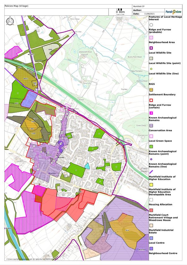
Markfield Parish Neighbourhood Plan:
‘Made’ Version

1.     Introduction
       Neighbourhood Plans
1.1.   The 2011 Localism Act has given communities the right to draw up a
       neighbourhood plan. This right is aimed at giving local communities genuine
       opportunities to influence the future of the places where they live.
1.2.   The Markfield Parish Neighbourhood Plan will allow people who live, work
       and have a business in the area to have a say where they think new houses
       and businesses should be located and what they should look like. A
       Neighbourhood Plan can also identify and protect important Local Green
       Spaces, conserve local heritage and protect areas of nature conservation
       interest. The Neighbourhood Plan can also identify locally valued landscapes
       and help maintain the character of the village. The Markfield Parish
       Neighbourhood Plan will be a statutory plan which means that once it has
       been finalised, decisions on planning applications will be made using both
       the Local Plan and the Neighbourhood Plan, and any other material
       considerations.

       The Markfield Neighbourhood Area
1.3.   The Markfield Neighbourhood Area comprises the whole of Markfield parish
       which lies some (8km) north-west of Leicester in the Hinckley and Bosworth
       Borough of Leicestershire, England. Markfield parish is located on the very
       edge of the Borough bordering both Charnwood Borough and North West
       Leicestershire District. The parish lies in both the National Forest and
       Charnwood Forest and is bisected by the M1 and the A50/A511. Markfield
       has a long association with the quarrying industry and has a type of granite
       named after it.
1.4.   Markfield village dates to at least the time of the Norman conquest and is
       mentioned in the Domesday Book under the name Merchenefeld. A variant
       of this is still used as the name for the village primary school, Mercenfeld.
       The village is to the south-east of Junction 22 of the M1, and to the south of
       the A50. The village has a good range of services and facilities.
1.5.   The parish includes the hamlet of Copt Oak in the north and the community
       of Shaw Lane to the west, but excludes Field Head. Field Head lies in Groby
       Parish, but is, for planning purposes, classed by Hinckley & Bosworth
       Borough Council as forming part of the Markfield and Field Head rural
       centre. Also, within the parish is Markfield Court retirement village and
       Markfield Institute of Higher Education.
1.6.   The Neighbourhood Area (Map 1) includes the whole of Markfield Parish.
       After consultation with neighbouring parish councils, Markfield Parish
       Council submitted the proposed Neighbourhood Plan Area to Hinckley &

                                          1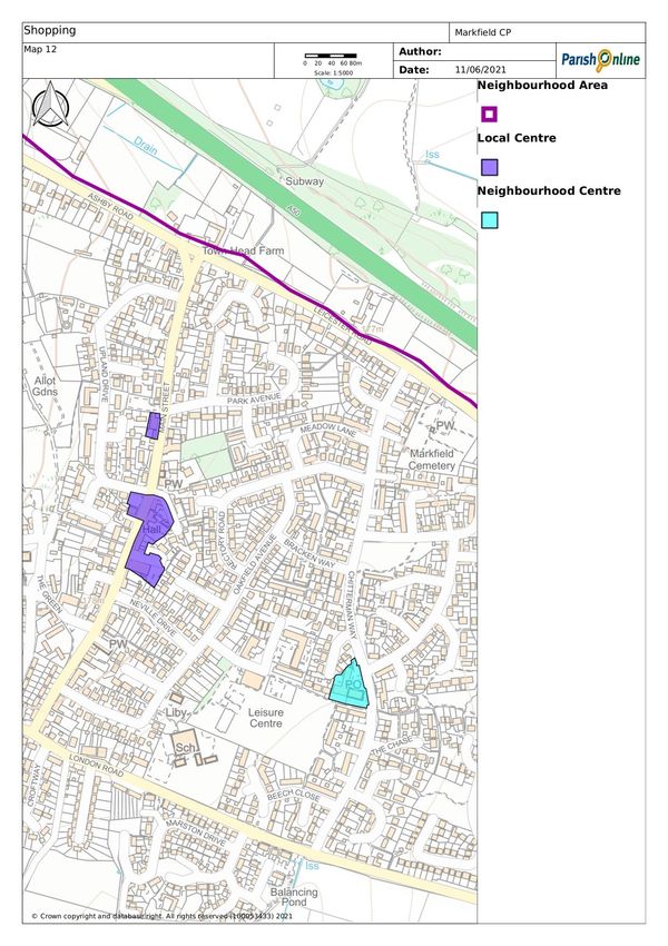
Markfield Parish Neighbourhood Plan:
‘Made’ Version
Bosworth Borough Council in March 2016. Following a six-week consultation
period, the Neighbourhood Area was designated on 11 May 2017.
1.7. The Neighbourhood Plan Area covers 882 hectares.
Basic Conditions
1.8. Only a draft Neighbourhood Plan that meets each of a set of basic conditions
can be put to a referendum and be adopted. This means that there is not an
entirely free hand over how the Plan is prepared. In particular, a
Neighbourhood Plan must have regard to the National Planning Policy
Framework (NPPF), National Planning Practice Guidance and the
Development Plan for the area.
National Planning Policy Framework
1.9. The revised National Planning Policy Framework was updated on 19 February
2019 and sets out the government’s planning policies for England and how
these are expected to be applied.
1.10. The planning practice guidance to support the framework is published
online.
Hinckley and Bosworth Local Plan
1.11. The relevant Development Plan for the area is the Hinckley and Bosworth
Local Plan which currently covers the period 2006-2026. For the purposes of
this Neighbourhood Plan, the relevant parts of the Local Plan are:
Core Strategy Development Plan Document (DPD)
1.12. The Core Strategy adopted on 15 December 2009, provides the vision and
broad strategy for Hinckley and Bosworth Borough. It states most new
development will be accommodated in and around Hinckley. The Core
Strategy also identifies development requirements for key rural centres
(such as Markfield and Field Head), Rural Villages and Rural Hamlets.
1.13. The Core Strategy expects Markfield and Field Head to provide the
necessary day-to-day services to ensure rural communities have the choice
to shop, work and play close to where they live. To support the local
services in Markfield and ensure local people have access to a range of
housing, Core Strategy Policy 8 aims to:
Allocate land for the development of a minimum of 80 new homes.
Developers will be required to demonstrate that the number, type and
mix of housing proposed will meet the needs of Markfield, taking into
account the latest Housing Market Assessment and local housing needs
surveys.
Support additional employment provision to meet local needs.
Address the existing deficiencies in the quality, quantity and
accessibility of green space and play provision in Markfield.
2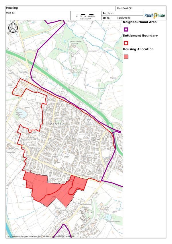
Markfield Parish Neighbourhood Plan:
‘Made’ Version

                          3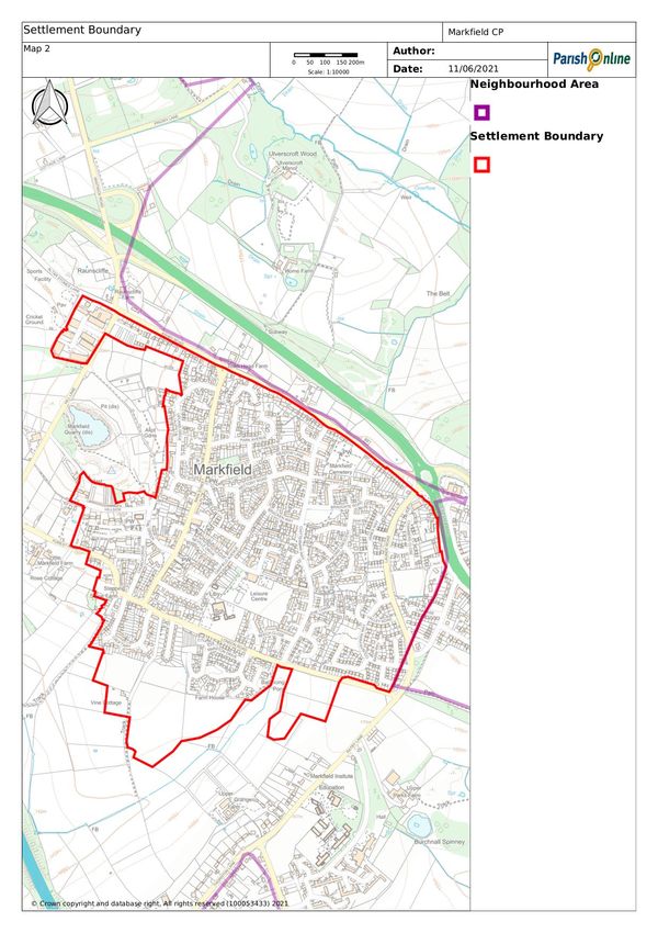
Markfield Parish Neighbourhood Plan:
‘Made’ Version
Implement the strategic green infrastructure network.
Support transport corridor disturbance mitigation and Markfield to Groby
public access.
Support proposals that contribute to the delivery of the National Forest
Strategy.
Deliver safe cycle routes, in particular from Markfield to South
Charnwood High School and between Markfield and Bardon Industrial
Estate.
Protect open space linkages to the west.
Support the expansion of the local supermarket to provide more choice
for local people, including an increase in car parking.
Support the attraction of knowledge-based services to support the
Markfield Institute of Higher Education which is linked to Loughborough
University.
Support improvement in the quality of Markfield Community and Sports
Centre and Mayflower Close and Alter Stones playing fields.
Support proposals that contribute to the delivery of the Charnwood
Forest Regional Park.
Support measures to reduce the noise and air pollution currently
experienced by the village due to its proximity to the M1.
Require new development to respect the character and appearance of
the Markfield Conservation Area.
Site Allocations and Development Management Policies DPD
1.14. This DPD identifies sites for uses such as housing, employment, retail, open
space and community facilities that will deliver the aims, vision and
objectives of the Core Strategy. It also contains 25 development
management policies which will be used to assess planning applications over
the plan period.
1.15. The residual minimum housing requirement for Markfield had been met and
so no sites are allocated for further residential development in this DPD.
Local Plan review
1.16. Work on the new Hinckley and Bosworth Local Plan began early in 2017. The
new Local Plan will set out the overall development strategy for Hinckley
and Bosworth Borough for the period 2020 to 2039. It will include strategic
policies and allocate sites to meet identified development needs such as for
homes, jobs, retail, recreation/open space, nature conservation and other
required land uses as identified by evidence. It will provide appropriate
policies and guidance by which to determine planning applications for
example design guidance, conservation and protection of natural resources.
1.17. The new Hinckley and Bosworth Local Plan will not be finalised until 2022 at
the earliest. This Neighbourhood Plan has been aligned with the emerging
4
Markfield Parish Neighbourhood Plan:
‘Made’ Version

      Local Plan to cover the period 2020 to 2039. However, once the new Local
      Plan is adopted there may be value in a review of the Neighbourhood Plan.

      Excluded Development
1.18. The Neighbourhood Plan cannot deal with excluded development such as
      county matters (mineral extraction and waste development), nationally
      significant infrastructure (for example major transportation and energy
      projects) or any other matters set out in Section 61K of the Town and
      Country Planning Act 1990. So, while quarries are an important feature of
      the local landscape, the Neighbourhood Plan cannot address mineral
      extraction, or the restoration and aftercare of mineral sites. However, the
      Neighbourhood Plan should have regard to Leicestershire County Council’s
      Minerals and Waste Local Plan (runs to 2031) when identifying suitable areas
      for non-mineral development.

      How the Plan has been prepared
1.19. The preparation of the Neighbourhood Plan has been led by Markfield Parish
      Neighbourhood Plan Steering Group on behalf of Markfield Parish Council
      which is the Qualifying Body.
1.20. In November
      2018, 35 people
      attended three
      public
      consultation
      events held in the
      Shaw Lane
      Working Men’s
      Club, Markfield
      Community
      Centre and
      Markfield Court.
      The events were
      used to inform
      local people
      about the             FIGURE 1: PUBLIC CONSULTATION EVENT
      neighbourhood
      plan process and receive views and opinions on the key issues that the
      Neighbourhood Plan should address.
1.21. The issues raised helped in the preparation of the Markfield Household
      Survey and 2,107 questionnaires were distributed to local households in
      November 2019. The total number of completed household questionnaires
      was 372.

                                        5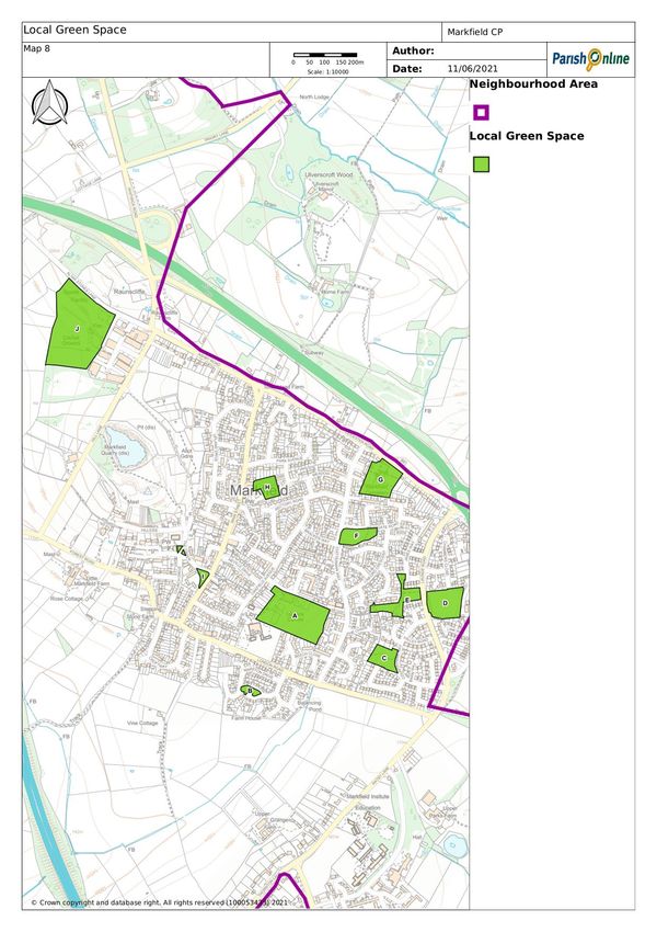
Markfield Parish Neighbourhood Plan:
‘Made’ Version

1.22. A survey of young people was also undertaken in 2019. The 2011 Census
      shows there to be 389 young people living in Markfield aged 10-17. 39
      completed questionnaires were returned from young people.
1.23. The results of both the household and young people questionnaires are
      available on the Parish Council website, https://npsg.markfieldpc.org.uk/
1.24. Throughout the plan preparation process, local people have been informed
      of progress through the website, presentations at Neighbourhood Plan
      Steering Group meetings, Parish Council meetings, noticeboards, Facebook
      and The Herald newsletter.
1.25. The feedback from consultation events, the questionnaire results and
      information about the area helped the preparation of a (Pre-Submission)
      Draft version of the Markfield Parish Neighbourhood Plan. Under Regulation
      14 of the Neighbourhood Planning (General) Regulations 2012, a pre-
      submission consultation period of no less than six weeks on the proposed
      Neighbourhood Plan ran from Monday 7 September to Monday 19 October
      and then extended to Friday 13 November 2020.
1.26. A copy of the Pre-Submission Draft of the Plan was made available to
      download, along with supporting documentation, on the Markfield Parish
      Council website, https://npsg.markfieldpc.org.uk/ . The consultation was
      advertised by way of an article in The Herald newsletter which was
      circulated to around 4,000 local homes and businesses. Printed copies of the
      Draft Neighbourhood Plan were available for reference at Markfield
      Community Library.
1.27. All the representations and comments received were considered by
      Markfield Parish Council and used to amend the Draft Neighbourhood Plan. A
      Consultation Statement, including a summary of all comments received and
      how these were considered, is available on the Parish Council website,
      https://npsg.markfieldpc.org.uk/
1.28. In February 2021 the Plan was submitted to Hinckley and Bosworth Borough
      Council for publication and, under Regulation 16 of the Neighbourhood
      Planning (General) Regulations 2012, public consultation took place between
      10 February and 24 March 2021.
1.29. Following the publicity and consultation stage, all comments were
      forwarded to the Neighbourhood Plan Examiner appointed by the Borough
      Council and Markfield Parish Council. On 28 May 2021, the Report of the
      Independent Examination was published. The Examiner recommended
      modifications to the Plan, that have been incorporated into this document,
      and then for it to be submitted to a referendum.

1.30. Hinckley and Bosworth Borough Council arranged a referendum for 9
      September 2021. On a turnout of 26.11%, 93.34% voted to in favour of the

                                        6
Markfield Parish Neighbourhood Plan:
‘Made’ Version
Neighbourhood Plan and 6.24% against. The Borough Council ‘made’ the
Neighbourhood Plan on 10 September 2021.
1.31. The Neighbourhood Plan is now in force as part of the statutory
Development Plan for the area. Hinckley and Bosworth Borough Council will
continue to be responsible for determining most planning applications, but
in the Markfield Neighbourhood Area, the policies in the Neighbourhood Plan
will form the basis of those decisions along with the adopted Local Plan and
other material considerations.
Note, when considering a development proposal, ALL the relevant
policies of the Neighbourhood Plan will be applied.
7Markfield Parish Neighbourhood Plan:
‘Made’ Version
2. Markfield Profile
2.1. Markfield village was recorded in the Doomsday Book of 1086 and known as
Merchenefeld in Anglo-Saxon times. It is one of the highest villages in
Leicestershire, being sited up against Markfield Knoll (known locally as Hill
Hole). Despite occupying an elevated location the village is well hidden.
2.2. Outcrops of rock together with granite cottages and boundary walls are the
key aspects of the village landscape.
2.3. Markfield in the 17th and early 18th century was essentially an agricultural
community providing much work for farmers, yeomen, husbandmen, graziers
and labourers. By 1800 Markfield had a population of around 600 residents
and it had been transformed into an industrial community with over 100
knitting frames in operation. By 1813 there were 99 houses in the village of
which 11 had a stable. Markfield’s population grew slowly and by 1891 had
1439 residents. The village then grew to meet the needs of successive forms
of industrial employment in the 19th century including quarrying and
mining.
2.4. As with many villages, the speed of development has increased significantly,
with much new housing developed over the last fifty to sixty years. Many
residents now commute to work and travel to shop and leisure activities,
using the M1, M69, A511 and A50.
2.5. There were 4,454 residents in the Parish at the time of the 2011 Census.
The average age was 46 years compared with 41.7 years in Hinckley and
Bosworth Borough.
2.6. The 2011 Census showed there to be 2,101 dwellings in the Parish. Council
Tax records show this to have grown to be around 2,200 now.
2.7. There were 1,590 residents aged 16 to 74 in Markfield (2011 Census), 75.3%
were economically active and 17.6% had retired.
8Markfield Parish Neighbourhood Plan:
‘Made’ Version
3. Sustainable Development and Vision
Sustainable Development
3.1. The Plan must contribute to the achievement of sustainable development.
The planning system has three overarching objectives, which are
interdependent and need to be pursued in mutually supportive ways (so that
opportunities can be taken to secure net gains across each of the different
objectives):
an economic objective – to help build a strong, responsive and
competitive economy, by ensuring that sufficient land of the right types
is available in the right places and at the right time to support growth,
innovation and improved productivity; and by identifying and
coordinating the provision of infrastructure;
a social objective – to support strong, vibrant and healthy communities,
by ensuring that a sufficient number and range of homes can be
provided to meet the needs of present and future generations; and by
fostering a well-designed and safe built environment, with accessible
services and open spaces that reflect current and future needs and
support communities’ health, social and cultural well-being; and
an environmental objective – to contribute to protecting and enhancing
the natural, built and historic environment; including making effective
use of land, helping to improve biodiversity, using natural resources
prudently, minimising waste and pollution, and mitigating and adapting
to climate change, including moving to a low carbon economy.
3.2. The Plan shows what sustainable development in Markfield means in
practice.
Vision
3.3. In setting out the aims for the Plan it is vital to consider how Markfield
should be at the end of the plan period. The Plan needs to be aspirational,
but realistic. The vision statement set out on the next page has helped
guide the preparation of the Markfield Parish Neighbourhood Plan and makes
it clear what the Plan is aiming to achieve. Our Vision statement is
supported by five broad statements of intent which have shaped the
structure of this document and our planning policies. 89% of respondents to
the 2019 Questionnaire Survey agreed with this vision statement.
9Markfield Parish Neighbourhood Plan: Referendum Version
The Markfield Parish Neighbourhood Plan aims to ensure our Parish remains
an attractive and desirable place to live meeting the needs of all, ensuring
the community enjoys a good quality of life and feels valued and
connected to each other. We aim to enhance and protect heritage assets,
wildlife and the landscape in an environment where homes, businesses and
facilities meet the needs of a contemporary rural community.
Environment & Facilities & Traffic &
Heritage Services Housing Transport
Business & To maintain and
To protect and To maintain, To ensure that
opportunities for Employment enhance sustainable
enhance the enhance and transport links
where required residential To continue to
wildlife, development in the within, to and from
expand the support the local
environment and Parish are managed economy, sustaining the Parish. To
heritage assets. existing provision support moves to
to provide the types existing businesses
Recognising the of facilities and and styles of reduce vehicle
services and and providing
need to plan for housing that are speeds and manage
opportunities for
ensure needed, considering parking in
climate change appropriate new
business
residential areas
and ensuring design, energy diversification and
provision is made efficiency, climate along with
public open new businesses to
for any future change and the transport generated
become established
spaces are developments need to meet the on suitable sites in
noise and pollution
accessible to all both within the requirements of all and increase the
the Parish.
and of a good Parish and in the residents. opportunities for
quality. safe walking and
surrounding areas. cycling.
10Markfield Parish Neighbourhood Plan:
Referendum Version
4. Environment and Heritage
Countryside
4.1. Markfield parish benefits from a beautiful, often rugged well treed
landscape, rich in wildlife sites and ancient rocks of international
importance. It lies entirely within the Charnwood Forest Regional Park and
the National Forest. These two designations provide extra protection to the
parish’s landscape when planning applications are considered. The parish is
also divided by three major roads – M1, A50 and A511 –which bring noise and
pollution. It also contains part of the expanding Bardon Hill Quarry and
adjoins the Old Cliffe Hill Quarry.
4.2. Our 2019 Questionnaire shows that residents use the countryside for walking
and rambling, with most respondents indicating that they walked along the
public footpaths daily or at least on a weekly basis. The local countryside is
highly valued by local people, so development there will be limited to
agriculture, forestry, recreation, tourism and other developments that are
suitable for a rural location.
Policy M1: Countryside
The Countryside (land outside the Settlement Boundary defined on Map 2
and the Policies Maps) will be protected for the sake of its intrinsic
character, beauty, heritage and wildlife, the wealth of its natural resources
and to ensure it may be enjoyed by all. The following types of development
will be supported in countryside locations:
1. Recreation and tourism that cannot be provided within the Settlement
Boundary;
2. Development by statutory undertakers or public utility providers;
3. The subdivision of an existing residential dwelling; and
4. Development that is otherwise in accordance with: national policies; or
strategic planning policies or allocations; or with the other policies of
the Neighbourhood Plan.
11Markfield Parish Neighbourhood Plan:
Referendum Version
12Markfield Parish Neighbourhood Plan:
Referendum Version
FIGURE 2: CHARNWOOD FOREST
13Markfield Parish Neighbourhood Plan:
Referendum Version
Charnwood Forest Regional Park
4.3. Charnwood Forest is a distinctive area of rugged unique upland landscape
which lies towards the north-western corner of Leicestershire. The Forest is
rural in character and is valued for its rich ecological, geological and
historical interests. The area is known for its rolling topography, high
woodland content and areas of rocky outcrops. It is bordered to the south
and east by the floodplain landscapes of the Rothley Brook system and to
the north-east by the joined Grand Union Canal and River Soar corridor. The
National Forest overlaps Charnwood Forest in the west of the area and
continues to the west. Charnwood Forest is an important area for recreation
and leisure and has long been identified in planning strategies and policies
as being unique and requiring special consideration. The whole of Markfield
Parish lies within the Charnwood Forest.
4.4. The Charnwood Forest Regional Park is a multi-partner initiative which looks
to develop and implement a strategy for the unique natural and cultural
heritage of Charnwood Forest. The 2019 Charnwood Forest Landscape
Character Assessment reviews and refines the original Charnwood Forest
Landscape Character Assessment (2008), but also intended to be used as a
tool for future decision making. The overall character of Charnwood Forest
is of a rolling landscape with an elevated topography and areas of woodland
and agriculture closely related to geology and hydrology. There are
contrasts between upland and lowland, which is closely associated with
watercourses and water features within the area. The 2019 Landscape
Character Assessment identified 11 distinctive Landscape Character Areas.
Markfield village lies within Area 6: Thringstone/Markfield Quarries and
Settlement, although other parts of the Parish lie in other Character areas.
Area 6: Thringstone/Markfield Quarries and Settlement
4.5. This area has a generally undulating landform but also includes several large
quarries which have greatly altered the natural landform over time.
Stanton-under-Bardon Quarry occupies most of the southern part of the area
with Bardon Hill Quarry located to the north. The quarries create extreme
low points but are often associated with local high points. Billa Barra Hill for
example reaches 235m above ordnance datum and is located adjacent to
the new Cliffe Hill Quarry while Bardon Hill Wood adjacent to Bardon Hill
Quarry reaches 278m AOD. This is also found at Markfield where Hill Hole
nature reserve lies at around 222m AOD and contains the former Hill Hole
Quarry. Away from these features, the landform is more gently undulating
with settlement in the north west associated with lower levels.
4.6. The area is highly settled with quarrying and associated spoil heaps being
locally significant landscape features. The other main land-uses are small
areas of mixed arable and pastoral farmland, small heathlands and
woodlands. Woodland is mixed with some pine plantations and some mixed
broadleaf and pine. There are also areas of new plantation and grasslands
14FIGURE 3: LANDSCAPE CHARACTER AREAS
Markfield Parish Neighbourhood Plan:
Referendum Version
15Markfield Parish Neighbourhood Plan:
Referendum Version
associated with areas of quarry restoration as well as The National Forest
Tender Scheme.
4.7. Markfield is a large village located on the eastern edge of the Character
Area. It has a clustered form and, unusually for Charnwood Forest, is mainly
built on a hillside. The A50/A511 and the M1 run nearby.
Area 2: Ulverscroft Wooded Valley
4.8. This area has a relatively peaceful, upland landscape of elevated
topography, heavily wooded and with little settlement. The combination of
ancient woodland, mature trees and weathered walls creates a sense of
maturity while the elevated topography and presence of stone walls and
rocky outcrops provide distinctive characteristics.
4.9. The area to the north of the A50/A511 corridor – around Copt Oak – is the
only part of this Character Area within the Neighbourhood Plan boundary.
Area 10: Groby/Ratby Wooded Farmland
4.10. This area has a gently rolling farmed landscape defined by a slight ridge
along Thornton Lane/Markfield Lane, with large areas of managed woodland
and some influences from settlements on the southern edge. Only the south-
eastern part of the Neighbourhood Area, to the east of Ratby Lane lies in
this Landscape Character Area.
Area 11: Thornton Plantation Farmlands
4.11. A rolling landscape of mixed farmland with areas of new woodland
plantation and modern features such as solar farms. Wide views across open
fields contrast with the Thornton Reservoir valley. Only the south-western
part of the Neighbourhood Area lies in this Landscape Character Area. This
includes the quadrant to the south-west of the built edge of Markfield, to
the east of the M1 and to the west of Thornton Lane/Ratby Lane.
Policy M2: Landscape Character
Development should be located and designed in a way that is sensitive to its
landscape setting, retaining and, where possible, enhancing the distinctive
qualities of the landscape character area (identified on Figure 3) which it
would affect.
Development should:
1. Conserve and, where possible, enhance the character and qualities of
the local landscape through appropriate design of development
proposals;
2. Retain and where possible enhance woodland, hedgerows, mature trees,
and stone walls as features of landscape importance unless it is
demonstrated this is not viable or practicable;
3. Be well integrated within the landscape with planting to soften urban
edges;
16Markfield Parish Neighbourhood Plan:
Referendum Version
4. Be located and designed so as not to significantly harm the important
long views from the publicly accessible locations at Billa Barra Hill, Hill
Hole, and Altar Stones identified on the Map of Views; and
5. Provide appropriate landscape mitigation and/or suitable off-site
enhancements.
National Forest
4.12. The 25year-old National Forest lies at the heart of the country, embracing
200 square miles of the Midlands. It spans across parts of Derbyshire,
Leicestershire and Staffordshire with the aim of linking the two ancient
Forests of Charnwood and Needwood. The National Forest is one of the
country’s boldest environmental projects, transforming an area with a
history of coal mining, clay extraction, stone and gravel quarrying and heavy
industry to a landscape that is now of rolling farmland, ancient forests and
new planted woodlands. The whole of the Neighbourhood Area lies within
the National Forest.
4.13. From the outset, one of the key objectives for the National Forest was the
creation of substantial new areas of forestry, which the ambitious goal to
increase woodland cover to about a third of all the land within its boundary.
Development and planning continue to have a key role in this creation.
Around 22% of all the Forest created to date has come through the planning
system.
4.14. Over its lifespan the National Forest has expanded its remit, from primarily
forest creation to include: forest management; wildlife conservation; access
creation, encouraging outdoor activity; tourism development and helping to
develop a low carbon economy.
4.15. Residential development over 0.5ha and commercial development over 1ha
is expected to contribute towards the creation of the Forest. This
expectation is contained within the Hinckley and Bosworth Local Plan (Core
Strategy Policy 21) and is reflected in paragraph 142 of the National
Planning Policy Framework.
Green Infrastructure
4.16. Green infrastructure (GI) embraces a range of spaces and assets that provide
environmental and wider benefits. It can, for example, include parks,
playing fields, other areas of open space, woodland, allotments, private
gardens, sustainable drainage features, green roofs and walls, street trees
and ‘blue infrastructure’ such as streams, ponds, canals and other water
bodies. Sites of importance for their biodiversity as well as important local
green spaces form part of green infrastructure
4.17. In some instances, GI sites exist in isolation, whereas in others they are
interconnected, either naturally or by planned actions, to form networks. GI
17Markfield Parish Neighbourhood Plan:
Referendum Version
18Markfield Parish Neighbourhood Plan:
Referendum Version
has been mapped at various scales – sub-regionally, county, district and at
parish (local) level.
4.18. Hinckley and Bosworth Borough Council Green Infrastructure Strategy 2020
identifies opportunities across the Borough to protect and enhance GI,
helping guide the investment and delivery of GI and its associated benefits.
It looked at the district-wide network of green spaces, pathways, bridleways
and wildlife corridors and showed how these connections could be improved
for the benefit of wildlife and recreation. In relation to Markfield, the Green
Infrastructure Strategy 2020 notes:
There are gaps in the provision of open space for children and young
people;
There is a significant cluster of land under biodiversity-related
Countryside Stewardship at Little Markfield Farm either side of the M1;
There is a concentration of older residents in Markfield;
Issues of noise pollution along the M1 corridor; and
Air pollution issues associated with major roads including the A511 and
M1.
4.19. Indeed, high and increasing traffic levels on the M1, A50 and A511 bring
issues of pollution from traffic fumes, noise and light for Markfield
residents. Although tree planting in places along the A50/A511 corridor has
helped to reduce the visual and physical effects of the road, there are
several areas where further work is needed particularly to the north and
west of Markfield. Substantial interventions are required, such as improving
the recreational offer and providing space that offers respite from the
transport corridors.
4.20. Furthermore, as the transport corridor traverses the National Forest, green
infrastructure interventions such as habitat creation and varied shrub and
tree planting can create a ‘feel’ of travelling through a woodland mosaic
landscape, reinforcing the National Forest’s identity.
4.21. At a parish level through schemes like the National Forest Tender Scheme,
various Leicestershire County Council grants and, in the case of the Bardon
Quarry extension, as a result of planning conditions, extensive areas of new
woodland have been created, hedges and trees planted. These, along with
existing woods, hedgerows etc. have contributed to provide an extensive
local green infrastructure network, which extends beyond the parish
boundary.
4.22. Access between Markfield and Groby is limited, and there are no public
rights of way that do not, at least in part, run alongside the busy A50. We
want to provide multi-user and traffic free access between Markfield and
Groby. Options include routing around Groby Pool or to the south of the A50
via Little John and Martinshaw Wood. Such improvements to the access
network will be vital not only for recreational and associated health
19Markfield Parish Neighbourhood Plan:
Referendum Version
20Markfield Parish Neighbourhood Plan:
Referendum Version
benefits, but also for providing sustainable transport options in and around
these settlements.
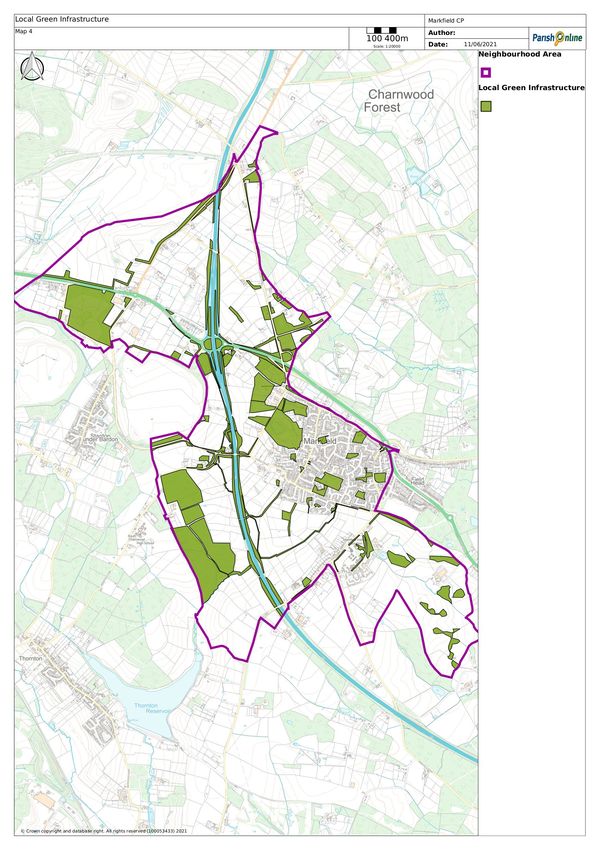
Policy M3: Green Infrastructure
To be supported development proposals must demonstrate how they avoid
significant harm to key features of the Green Infrastructure network
identified on Map 4 and the Policies Maps. Where harm is demonstrated to
be unavoidable proposals must mitigate and compensate for that harm.
Proposals that create a new footway, cycle and bridleway route towards
Groby; or mitigate traffic impacts along the A50/A511/M1 road corridors; or
otherwise enhance the local Green Infrastructure network identified on Map
4 will be supported.
Biodiversity
4.23. There are no Sites of Special Scientific Interest (sites designated by Natural
England under the Wildlife and Countryside Act 1981) in Markfield Parish.
However, there are some SSSIs nearby including Cliffe Hill Quarry, Bardon
Hill, Bardon Hill Quarry and Ulverscroft Valley.
4.24. The Neighbourhood Area does contain a Local Nature Reserve and several
locally designated ‘Local Wildlife Sites’ (LWS)- areas of substantive nature
conservation value that make an important contribution to ecological
networks. There are also several Regionally Important Geological Sites
(RIGS) and 3 draft Open Mosaic sites (as defined by Natural England).
4.25. The Neighbourhood Plan identifies and maps these sites, and Policy M4 not
only secures their protection from harm or loss but also helps to enhance
them and their connection to wider ecological networks.
4.26. Notable species with European or UK Legal Protection that have been
recorded in the area include Badger, Bat, European Otter, Water Vole, Barn
Owl, Brambling, Fieldfare, Hobby, Osprey, Peregrine, Red-throated Diver,
Redwing, Red Kite, Common Frog, Common Lizard, Common Toad, Great
Crested Newt, Palmate Newt, Smooth Newt, White-clawed Crayfish,
Bluebell.
Billa Barra Hill Local Nature Reserve
4.27. Billa Barra Hill is a 20.7 hectares (51 acres) Local Nature Reserve north of
Stanton under Bardon. It is owned and managed by Hinckley and Bosworth
Borough Council. It is also designated as Local Wildlife Sites (12544 and
72527).
21Markfield Parish Neighbourhood Plan:
Referendum Version
4.28. The hilltop contains
areas of acid
grassland and an
old conifer
plantation. The
pools in the
abandoned quarry
support a variety of
species, including a
rare lichen, only
found at one other
site in
Leicestershire. FIGURE 4: BILLA BARRA HILL LOCAL NATURE RESERVE
The improved
grassland on the slopes of the hill below the gorse scrub line are being
planted with native broadleaved trees which will be used as local
provenance seed stock. The site is a good area for warblers, particularly
around the gorse areas.
Hill Hole Quarry Nature Reserve
4.29. One of the earliest quarries in the Leicester area, Hill Hole Quarry was
opened in the 1850s for the extremely hard granite known as Markfieldite.
This is still a highly sought-after type of granite. Closed before World War 2,
Hill Hole has
been turned into
a nature reserve
supporting a
wide variety of
wildlife including
the protected
and rare white-
clawed crayfish
in the lake. The
summit of the
hill is nearing FIGURE 5: VIEW FROM HILL HOLE EASTWARDS TO BRADGATE PARK
230 metres
above sea level and there is a trig point and a toposcope pointing out
features in the views spanning over 50 miles to Coventry, Leicester,
Birmingham, the Shropshire Hills and the Cotswolds.
22Markfield Parish Neighbourhood Plan:
Referendum Version
23Markfield Parish Neighbourhood Plan:
Referendum Version
See Policy 4 for
references. Some sites
24
overlap.Markfield Parish Neighbourhood Plan:
Referendum Version
See Policy 4 for
25
references.Markfield Parish Neighbourhood Plan:
Referendum Version
4.30. This old granite quarry is now managed as a nature reserve. Part of the site
is flooded and this is fenced off. The site has several wooded areas,
including trees that have naturally colonised such as Oak and Ash along with
some Mountain Ash and Downy Birch. The sparse, acid soils offer good
habitat for heathland plants such as Gorse and Heath Bedstraw. There is a
good variety of insects including several butterfly species such as Large
Skipper, Gatekeeper and Speckled Wood.
Altar Stones Nature Reserve
4.31. Altar Stones is a 3.7-hectare (9.1-acre) nature reserve that is owned and
managed by the Leicestershire and Rutland Wildlife Trust.
4.32. This site has outcrops of Precambrian volcanic rocks and drystone walls
providing cover and shelter for a variety of insects, lichens and mosses. The
breakdown of these rocks creates the perfect conditions for heath-grassland
that was once typical in Charnwood Forest, and the grasses, herbs and
lichens that thrive here are diverse, varied and, in some cases, very rare in
Leicestershire.
4.33. At the top of
the hill there
are views over
parts of
Leicestershire
and the
Midlands.
Elsewhere the
stone pads
from the old
pillar
windmill,
which once
occupied part FIGURE 6: ALTAR STONES LOCAL WILDLIFE SITE
of the site,
have been recreated and remains of the miller’s store can still be seen.
Policy M4: Ecology and Biodiversity
To be supported development proposals that cannot avoid harm to the
biodiversity, or the geological significance of the following sites must
include adequate mitigation, or as a last resort compensate for that harm:
Billa Barra Hill Local Nature Reserve
Hill Hole Quarry Nature Reserve
Altar Stones Nature Reserve
Local Wildlife Sites:
26Markfield Parish Neighbourhood Plan:
Referendum Version
12544 Billa Barra Hill Nature Reserve
25283 Field South of Ulverscroft Wood
25374 Field North of Leicester Road
33856 Hill Hole Meadow
39269 Markfield Roadside Verge Nature Reserve 1
42896 Markfield Roadside Verge Nature Reserve 3
48479 Markfield Roadside Verge Nature Reserve 2
54201 Raunscliffe
64650 Bardon Woodland Belt 1
65169 Shaw Lane, Hedgerow Ash
72527 Billa Barra Hill
72528 Hill Hole Quarry
80053 Altar Stone
90453 Land Adjacent Cricket Ground
90695 Lower Grange Farm Hedge
91172 Veteran Horse Chestnut off Main Street
91533 Elliott’s Lane Hedge
91534 Cliffe Hill Road Verge
91816 Grassland by Stoney Farm
Regionally Important Geological Sites:
12603 Markfield Hill Hole Quarry
12619 Groby Upper Park
12620 Groby Park
12622 Altar Stones
Proposals for biodiversity conservation or enhancement of the following
types will be supported:
1. Management of woodlands, open grasslands and water features;
2. Restoration of drystone walls;
3. Planting of gaps in hedgerows to strengthen historic field patterns and
management of over-mature hedges;
4. Tree planting to replace mature/veteran trees as they come to the end
of their lives.
5. Maintenance of or creation of new stock fencing to prevent damage to
the above.
Trees
4.34. There are many significant mature trees in Markfield and these all play a
role in framing key buildings, softening the built fabric and enhancing the
special character of the village. There are many trees in the village and
Little Shaw Lane that are subject to Tree Preservation Orders (TPOs) which
protects and preserve trees for public enjoyment, environmental and
aesthetic purposes. Trees in Markfield Conservation Area are also protected.
Any tree over 75mm in diameter at 1.5m above ground level is given
automatic protection in the Conservation Area. No cutting, removal, wilful
27Markfield Parish Neighbourhood Plan:
Referendum Version
damage or destruction of such trees is allowed without giving prior
notification to Hinckley and Bosworth Borough Council.
Policy M5: Trees
To be supported development proposals that will result in the unavoidable
loss of trees or hedgerows must include replacement planting of native
species in locations where they would have the opportunity to grow to
maturity, increase canopy cover and contribute to the local ecosystem and
the appearance of the area.
Local Green Spaces
4.35. National policy makes provision for local communities to identify green
areas of importance to those communities, where development will not be
permitted except in very special circumstances. The term ‘very special
circumstances’ in relation to designated Local Green Spaces is required by
the NPPF. To show there are ‘very special circumstances’ an applicant will
need to demonstrate that the potential harm to the Local Green Space in
question, including the reasons for its designation and any other harm
resulting from the proposal, is clearly outweighed by other considerations.
FIGURE 7: COMMUNITY PARK
28Markfield Parish Neighbourhood Plan:
Referendum Version
29Markfield Parish Neighbourhood Plan:
Referendum Version
4.36. The reasons for designating these Local Green Spaces are summarised in
Appendix 1.
Policy M6: Local Green Spaces
The following areas identified on Map 8 are designated as Local Green
Space:
A. Community Park
B. Chapman Close
C. Countryman Way
D. Launde Road
E. Whitcroft Close
F. Bradgate Road
G. The Leicester Road Cemetery
H. Millennium Garden
I. Sawpits Green and the two Upper Greens
J. Jubilee Playing Fields
Climate Change
4.37. Climate change is now the greatest challenge facing our society. The
scientific evidence of climate change is overwhelming, and the global
impacts of climate change will be severe. It is often seen as a long-term
challenge, but, as the latest IPCC (Intergovernmental Panel on Climate
Change) report makes clear, the impacts are being experienced now,
through unprecedented global trends and through more localised severe
weather events. While climate change will have a lasting impact on people
and wildlife, it will also define future economic progress. Only those places
that can demonstrate climate resilience will be able to secure insurance and
investment.
4.38. It had been assumed that to avoid climate change’s worst impacts, it was
vital to secure climate stabilisation at less than a 2oC global temperature
increase above pre-industrial levels. This is the foundation of the UN Paris
Agreement on climate change. However, the latest science indicates that
1.5oC is a more realistic target to avoid these worst extremes. Even if we
can stabilise temperatures at or below the 1.5oC target there will still be
significant impacts through severe weather incidents and sea level rise.
Above all, the latest IPCC report illustrates the vital need to reduce climate
change emissions now by transforming our energy systems.
4.39. Planning plays a central role in the transition to a low-carbon society,
engaging communities and enabling environmentally friendly choices in
everything from energy to transport. We can do this by shaping new and
existing developments in ways that reduce carbon dioxide emissions and
positively build community resilience to problems such as extreme heat or
flood risk. 74% of respondents to the 2019 Questionnaire Survey indicated
30Markfield Parish Neighbourhood Plan:
Referendum Version
that they would like to make Markfield Parish as carbon neutral as possible
by 2036.
Renewable Energy
4.40. Increasing the amount of energy from renewable and low carbon
technologies will help ensure the UK has a secure energy supply, reduce
greenhouse gas emissions to slow down climate change and stimulate
investment in new jobs and businesses. Planning has an important role in
the delivery of new renewable and low carbon energy infrastructure in
locations where the local environmental impact is acceptable.
4.41. Land Use Consultants Ltd (LUC) and the Centre for Sustainable Energy (CSE)
were commissioned to prepare a Renewable Energy Capacity Study for
Hinckley and Bosworth Borough Council. The 2014 study concluded that the
technical potential for renewable and low carbon energy within the Borough
is substantial and the technologies with the greatest technical resource for
electricity generation are wind, solar photovoltaic (PV) (particularly solar
farms) and ground source/air source heat pumps which domestically do not
generate electricity but use electricity in an environmentally beneficial way
to pump heat energy into the property.
4.42. Our 2019 Questionnaire Survey showed that small-scale renewable energy
technologies integrated with new buildings or fitted to existing buildings was
given the highest level of priority from respondents. Local Solar Energy
Farms was also popular, with the least popular being ‘Local Wind Farms’.
Solar Farms
4.43. Solar farms (sometimes known as solar parks or solar fields) are the large-
scale application of solar PV panels to generate green, clean electricity at
scale, usually to feed into the grid. Solar farms can cover anything between
1 acre and 100 acres.
Wind Energy
4.44. One of the key factors determining the acceptability or otherwise of wind
turbines is their potential impact on the local landscape – this is due to their
height and the movement they introduce into the landscape (i.e. rotating
blades). The Renewable Energy Capacity Study found that the landscapes in
Hinckley and Bosworth have a moderate/moderate high sensitivity to large
scale turbines. The Neighbourhood Area is particularly sensitive to wind
turbines because its distinctive landform allows for great inter-visibility with
the surrounding countryside. The Area is also part of the Charnwood Forest
Regional Park and National Forest. In the past planning applications for wind
turbines at Little Markfield Farm (Ref: 14/01258/FUL) and Stanton Lane
Farm (Ref: 12/00399/FUL and 12/00091/FUL) have either been refused or
withdrawn.
31Markfield Parish Neighbourhood Plan:
Referendum Version
Microgeneration Technologies
4.45. Many microgeneration technologies projects, such as domestic solar PV
panels, ground source and air source heat pumps are often permitted
development which means they do not require planning permission providing
certain limits and conditions are met. In view of Markfield being in the
National Forest, the incorporation of renewable wood fuel heating systems
is particularly appropriate.
Policy M7: Renewable Energy
Ground-mounted solar photovoltaic farms will be supported provided that:
1. Wherever possible previously developed (brownfield) or non-agricultural
land is used;
2. Their location in the landscape is selected sensitively;
3. Their impact on heritage assets, where applicable, has been fully
assessed and addressed;
4. Their visual impact, both individually and cumulatively, has been fully
addressed;
5. The installations are removed when they are no longer in use, and the
land is fully restored.
Energy Efficiency Requirements
4.46. By 2025, the Government is intending to introduce a Future Homes Standard
for new build homes to be future-proofed with low carbon heating and
world-leading levels of energy efficiency.
4.47. Currently, energy efficiency requirements for new homes are set by Part L
(Conservation of Fuel and Power) and Part 6 of the Building Regulations. Our
Neighbourhood Plan cannot be used to set energy efficiency standards for
new homes that exceed the requirements of the Building Regulations.
Electric Vehicle Chargepoints
4.48. Past and current governments have supported measures to encourage
uptake of Electric Vehicles (EVs, sometimes referred to as Ultra Low
Emission Vehicles or ULEVs) as they can contribute to a wide range of
transport policy goals. These include improving air quality and reducing
noise pollution and helping meet the current 2050 net zero emission
greenhouse gas targets. Another stimulus for change is the Government
bringing forward, to 2035, the date after which new petrol and diesel
powered cars can’t be sold. The Government’s 2018 Road to Zero Strategy
outlines how it will support the transition to zero emission road transport
and reduce emissions from conventional vehicles. To meet the aims of the
Strategy, Government is providing grants to make selected electric vehicle
32You can also read


