Yangebup and Little Rush Lakes Master Plan
←
→
Page content transcription
If your browser does not render page correctly, please read the page content below
Yangebup and Little Rush Lakes Master Plan

Document Set ID: 9374684
Version: 1, Version Date: 22/05/2020

Date               Revision   Description                                       Approved
              02.09.2019         A          Draft for Comment                                 P. Jordan
              02.10.2019         B          Draft for Comment                                 P. Jordan
              28.10.2019         C          Final Draft                                       P. Jordan
              28.02.2020         D          Final Issue                                       P. Jordan
              18.05.2020         E          Final Issue Amendments                            P. Jordan

                                                      City of Cockburn I Yangebup and Little Rush Lakes Master Plan I 1
Document Set ID: 9374684
Version: 1, Version Date: 22/05/2020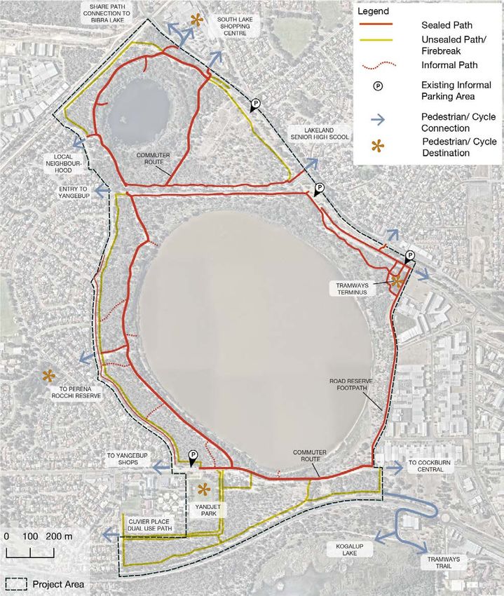
Table of Contents
                Summary ..................................................................................................................... 5
                1.1       Introduction .................................................................................................................... 5
                1.2       Master Plan Preparation ................................................................................................ 5
                1.3       Master Plan Vision ......................................................................................................... 5
                1.4       Master Plan Objectives .................................................................................................. 5

                Acknowledgements .................................................................................................... 7

                2 Management directions ........................................................................................ 8
                2.1       Introduction .................................................................................................................... 8
                2.2       Key Values..................................................................................................................... 8
                2.3       Project Area ................................................................................................................... 8
                2.4       Policy Framework ........................................................................................................ 10

                3 Consultation ........................................................................................................ 12
                3.1       Consultation Overview ................................................................................................. 12
                3.2       Key Stakeholders......................................................................................................... 12
                3.3       Engagement Principles And Process .......................................................................... 12
                3.4       Consultation Outcomes ............................................................................................... 13

                4 Historical overview ............................................................................................. 15
                4.1       Aboriginal Land Use And Significance ......................................................................... 15
                4.2       European History ......................................................................................................... 15
                4.3       Recent History and Recreational Uses ........................................................................ 16

                5 Current Status of the Reserves ......................................................................... 19
                5.1       Surrounding Context .................................................................................................... 19
                5.2       Tenure ......................................................................................................................... 20
                5.3       Climate......................................................................................................................... 23
                5.4       Geology, Geomorphology and Soils ............................................................................ 24
                5.5       Hydrology, Surface and Subsurface ............................................................................ 25
                5.6       Ecology ........................................................................................................................ 26
                5.7       Existing vegetation....................................................................................................... 28
                5.8       Fauna........................................................................................................................... 32

                                                                        City of Cockburn I Yangebup and Little Rush Lakes Master Plan I 2
Document Set ID: 9374684
Version: 1, Version Date: 22/05/2020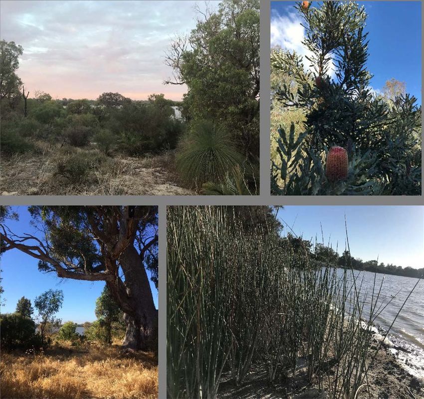
5.9       Threats and Threatening Processes ............................................................................ 34
                5.10      Vulnerability to Change................................................................................................ 38

                6 Landscape and Recreation Review ................................................................... 41
                6.1       Recreational Amenity in the Project Area .................................................................... 41
                6.2       Existing Recreational Facilities .................................................................................... 46
                6.3       Access, Circulation and Connectivity ........................................................................... 51
                6.4       Signage........................................................................................................................ 56
                6.1       Public Art ..................................................................................................................... 58
                6.2       Special Interest Features ............................................................................................. 60

                7 Concept Plan ....................................................................................................... 61
                7.1       Concept Design ........................................................................................................... 61
                7.2       Opportunities ............................................................................................................... 61
                7.3       Revegetation and Amenity Planting ............................................................................. 64
                7.4       Monitoring .................................................................................................................... 67
                7.5       Research ..................................................................................................................... 67
                7.6       Review ......................................................................................................................... 67
                7.7       Supplementary Plans and Programs ........................................................................... 67

                8 Recommendations .............................................................................................. 68
                8.1       Overview ...................................................................................................................... 68
                8.2       Recreation Infrastructure Recommendations .............................................................. 68
                8.3       Environmental Management Recommendations ......................................................... 77

                9 Yandjet Park Concept Design ............................................................................ 80
                9.1       Site Description............................................................................................................ 80
                9.2       Consultation ................................................................................................................. 81
                9.3       Design Rationale/ Key Elements ................................................................................. 82

                References ................................................................................................................ 84

                Report Appendices ................................................................................................... 85
                Appendix 1 Master Plan Concept ............................................................................................ 85
                Appendix 2 Master Plan Priorities List..................................................................................... 85
                Appendix 3 Yandjet Park Concept .......................................................................................... 85

                                                                        City of Cockburn I Yangebup and Little Rush Lakes Master Plan I 3
Document Set ID: 9374684
Version: 1, Version Date: 22/05/2020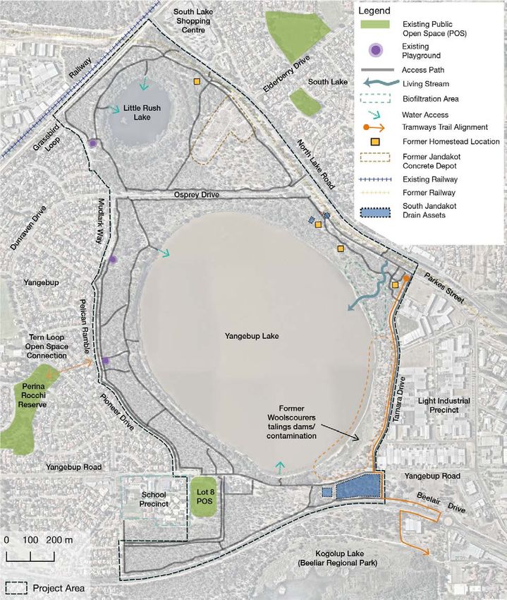
Appendix 4 Yandjet Park Works Outline ................................................................................. 85
                Appendix 5 Birdata Species List.............................................................................................. 85

                Figures, Maps and Tables
                Figure 1 Rainfall and Temperature Data: Jandakot Aero BoM station ..................................... 23

                Map 1 Project Area ................................................................................................................... 9
                Map 2 Sociocultural Elements ................................................................................................ 18
                Map 3 Surrounding Context .................................................................................................... 19
                Map 4 Reserve Tenure ........................................................................................................... 21
                Map 5 Soils of the Project Area .............................................................................................. 25
                Map 6 Vegetation Communities.............................................................................................. 30
                Map 7 Vegetation Condition ................................................................................................... 31
                Map 8 Visual Catchments and Vistas ..................................................................................... 45
                Map 9 Reserve Fences and Entry Points ............................................................................... 50
                Map 10 Path Network .............................................................................................................. 54
                Map 12 Existing Public Artwork ............................................................................................... 59
                Map 13 Opportunities .............................................................................................................. 63
                Map 14 Proposed Rehabilitation Management Zones ............................................................ 66

                Table 1 Land titles/ lots included in the Project Area .............................................................. 22
                Table 2 Master plan recommendations for Recreational infrastructure in the reserves .......... 76
                Table 3 Master plan recommendations for environmental management of the reserves ....... 79

                                                                       City of Cockburn I Yangebup and Little Rush Lakes Master Plan I 4
Document Set ID: 9374684
Version: 1, Version Date: 22/05/2020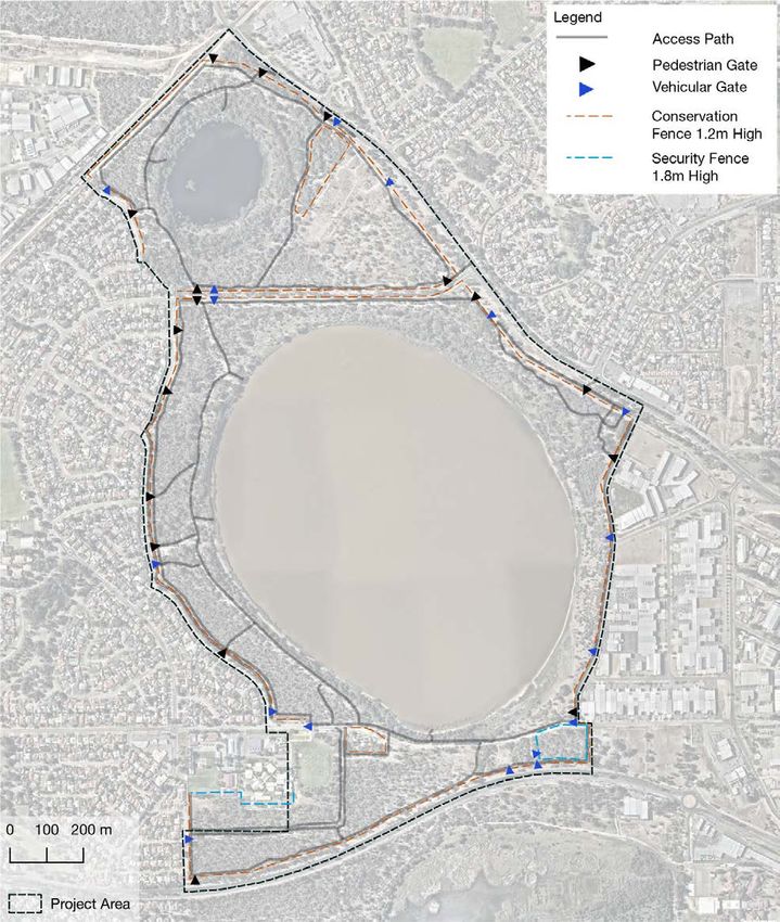
Summary
                1.1         Introduction
                Yangebup Lake and Little Rush Lake Reserves are an important component of the Beeliar
                Regional Park and an important recreational asset for surrounding suburbs. The project area
                includes the bushland and foreshore of the reserves, the water bodies and the surrounding
                road reserves. The Yangebup Lake water body is not under City of Cockburn management,
                however is considered due to its relevance to management of the reserve.

                1.2         Master Plan Preparation
                The City of Cockburn’s Strategic Community Plan 2016-2026 identifies five key strategic
                objectives which will help fulfil its vision. Two of these, Economic, Social and Environmental
                Responsibility and Community, Lifestyle and Security support the need to develop a master
                plan for Yangebup and Little Rush Lakes.
                The Master Plan builds on previous management plans that have resulted in rejuvenation of
                the bushland and improvement of water quality over an extended period. Consultation was
                undertaken with a range of community and agency stakeholders the contributions of whom
                have assisted in development of the plan’s recommendations.

                1.3         Master Plan Vision
                To protect, enhance and promote the natural and cultural values of Yangebup and Little Rush
                Lake Reserves enabling sustainable community use through the provision of a range of
                conservation, recreation and environmental education opportunities.

                1.4         Master Plan Objectives
                The Master plan objectives are to:
                      1. Ensure that any upgrades, development and activities undertaken within each reserve
                         is consistent with the City of Cockburn Natural Areas Management Strategy.
                      2. Ensure that the parks are not degraded by ad hoc additions and activities that do not
                         consider the parks in their entirety and their conservation status.
                      3. Foster a distinctive identity for the Reserves that is based on natural, conservation and
                         community values.
                      4. Protect and enhance natural, environmental and conservation values and offer a
                         sanctuary for local fauna.
                      5. Protect and enhance the cultural and heritage values of the reserves.
                      6. Provide guidance for the improvement of the water quality in each of the lakes in
                         accordance with the City’s Water Sensitive Urban Design (WSUD) and biofiltration
                         initiatives.
                      7. Strengthen and progress each reserve as regional parks that are recognised by locals
                         and the broader community as two of the best managed parks for conservation and
                         natural uses in the Perth metropolitan area.

                                                         City of Cockburn I Yangebup and Little Rush Lakes Master Plan I 5
Document Set ID: 9374684
Version: 1, Version Date: 22/05/2020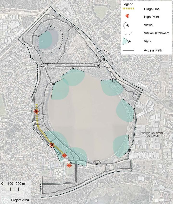
8. Suggest ways to improve regional pedestrian and cycle connectivity through and in
                        proximity to the reserves.
                The Master Plan includes Recommendations, a Concept Design and Priorities List for
                environmental management and infrastructure upgrades over a ten-year period.

                                                     City of Cockburn I Yangebup and Little Rush Lakes Master Plan I 6
Document Set ID: 9374684
Version: 1, Version Date: 22/05/2020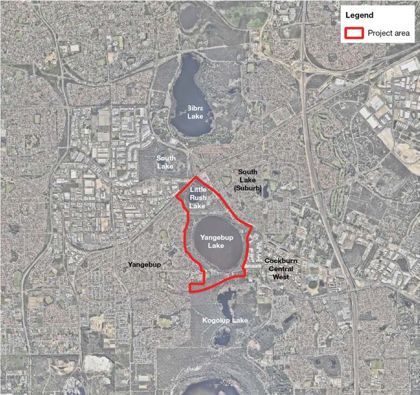
Acknowledgements

                We wish to thank the following stakeholder groups and agencies for their contribution to the
                Yangebup and Little Rush Lake master plans:
                • Yangebup Progress Association
                • South Lake Connect
                • City of Cockburn Aboriginal Reference Group
                • Department of Biodiversity, Conservation and Attractions (Regional Parks Unit)
                • Beeliar Regional Park Community Advisory Committee
                • Mater Christi Catholic Primary School
                • BirdLife Australia

                                                     City of Cockburn I Yangebup and Little Rush Lakes Master Plan I 7
Document Set ID: 9374684
Version: 1, Version Date: 22/05/2020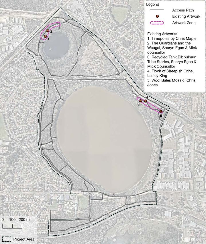
2           Management directions
                2.1         Introduction
                Yangebup Lake and Little Rush Lake Reserves possess regionally significant environmental
                and recreational values. The reserve wetlands form part of the eastern Beeliar Wetland Chain
                and are important habitat and ecological linkages in the City of Cockburn. The lakes are a
                valued recreational destination for nearby residents and some recreational infrastructure exists
                to support this. The increased urbanisation of surrounding areas and demand on reserves as
                a recreational destination requires enhancement of infrastructure that is balanced with habitat
                and conservation values.
                The master plan presents direction for reserve management over a ten-year period from 2020
                to 2030. The report includes a brief overview of the Reserves’ history, a summary of community
                and stakeholder consultation undertaken as part of the project and an analysis of current
                conditions. Opportunities and recommendations for upgrades to recreational facilities and
                environmental management with priorities make up the remainder of the report.

                2.2         Key Values
                The overarching values of the reserves include habitat conservation and amenity for passive
                recreational uses. Natural areas in urban environments provide health benefits including
                improved air and water quality, help cities avoid temperature extremes and are linked to lower
                rates of chronic disease. Contact with nature has a positive impact on mental health and
                encouraging the use of the pedestrian and cycle network promotes activity and social
                participation. There are an enormous range of potential health and wellbeing benefits from
                contact with nature including crime reduction, psychological wellbeing, reduced stress,
                boosted immunity, enhanced productivity, improved mental health, reduced blood pressure,
                heart rate and cholesterol and spiritual development.
                Areas of both reserves have in the past been extensively modified with environmental and
                recreational values degraded. This condition has improved considerably through management
                by the City of Cockburn and the reserves now support an array of flora and fauna and improved
                water quality. Management seeks to strengthen these values and realise the potential for the
                improvement of bushland and water quality and integration with reserves of the Beeliar
                Regional Park.

                2.3         Project Area
                The project area comprises of Yangebup Lake and Little Rush Lake Reserves and is located
                centrally to the City of Cockburn. The project area includes the reserves in addition to
                consideration of adjacent road reserves that provide public access and ecological buffers for
                reserve habitats. Combined, this amounts to approximately 200 hectares, of which 85.49
                hectares are classified as bushland.
                The wetlands of the project area form part of the Beeliar Wetlands Eastern Chain and are of
                high importance to ecological connectivity for the Beeliar Regional Park. Reserves to the
                north of the project area include South Lake and Bibra Lake and to the south include Kogolup
                Lake and Thompsons Lake Nature Reserve. Bibra Lake forms a major destination within the
                City and includes a number of recreational attractions. Thompsons Lake Nature Reserve to

                                                       City of Cockburn I Yangebup and Little Rush Lakes Master Plan I 8
Document Set ID: 9374684
Version: 1, Version Date: 22/05/2020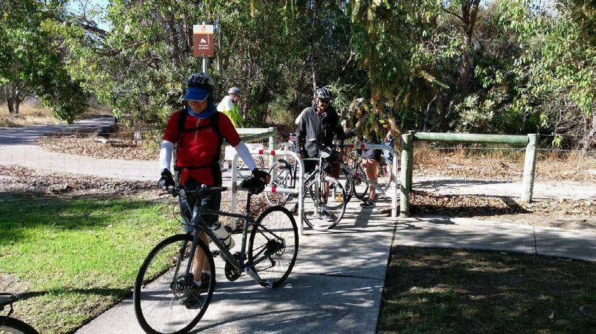
the south is a RAMSAR classified wetland with high conservation value and has
comparatively minimal recreational infrastructure.
The project area is located between the suburbs of Yangebup to the west, South Lake to the
east and the light industrial area of Cockburn Central to the south-east. All areas discussed
are under management by the City of Cockburn however the water body of Yangebup Lake
is under the management of the Western Australian Planning Commission.
Throughout this report Yangebup and Little Rush Lake Reserves are referred to as the
‘Reserves’ that includes the main lots allocated to parks and recreation in the project area.
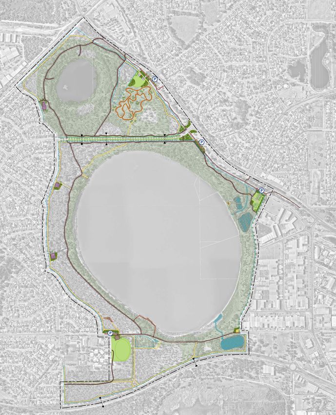
Map 1 Project Area
City of Cockburn I Yangebup and Little Rush Lakes Master Plan I 9
Document Set ID: 9374684
Version: 1, Version Date: 22/05/20202.4 Policy Framework
The City of Cockburn
The City of Cockburn is responsible for managing the Reserves of Yangebup Lake and Little
Rush Lake on behalf of WAPC (Western Australian Planning Commission). Due to the water
quality in the Yangebup Lake the water body remains under the management of the WAPC.
Reserve management is undertaken by City of Cockburn Staff in accordance with the City’s
Natural Area Management Strategy 2012-2022 (2018 review) and the Beeliar Regional
Management Plan.
Natural Area Management Strategy
The City of Cockburn’s Natural Area Management Strategy provides the overarching
framework for management of the reserves. The strategy outlines the City’s approach to
managing its vested natural areas and building its capacity to maintain them for the
conservation of biodiversity. There are 12 natural area management objectives with
corresponding KPI’s (Key Performance Indicators) to assess the performance of the City’s
management. The ultimate goal of the strategy is for all of the City’s natural areas to have a
vegetation condition rating of good or better based on the Keighery (1994) definition of
vegetation condition. The condition is mapped every four years to determine the effectiveness
of rehabilitation efforts.
In the Strategy’s actively managed reserve classification, Little Rush Lake (Reserve 43) is
identified as High Priority for rehabilitation and maintenance with 38.01 hectares of bushland
and a total reserve area of 42.44 hectares. Yangebup Lake is a Medium Priority for
rehabilitation and maintenance with 47.48 hectares of bushland and a total reserve area of
141.89 hectares.
The strategy provides the framework for management of the reserve’s natural areas. Other
City documents referenced by the strategy and forming its strategic alliance include:
• City of Cockburn Strategic Community Plan 2016-2026
• City of Cockburn Sustainability Strategy 2017-2022
• Long Term Financial Plan 2016-2026
• Public Open Space Strategy 2014-2024
• Urban Forest plan 2018-2028.
Beeliar Regional Park Management Plan (BRPMP)
The Reserves form part of the Beeliar Regional Park and are subject to the Beeliar Regional
Park Management Plan that was prepared on behalf of the Conservation Commission of
Western Australia in accordance with the Conservation and Land Management Act 1984.
DBCA (Department of Biodiversity Conservation and Attractions) is responsible for
coordinating the implementation of the Management Plan throughout the Reserves and the
City of Cockburn manages Yangebup and Little Rush Lake Reserves adhering to the following
directives of the Beeliar Regional Park Management Plan:
• Managing the Reserves for biodiversity conservation, and encouraging recreation and
other uses to take place but only to the extent that they do not adversely impact on the
other values of the Reserves
City of Cockburn I Yangebup and Little Rush Lakes Master Plan I 10
Document Set ID: 9374684
Version: 1, Version Date: 22/05/2020• Applying DBCA policies in managing the park
• Preparing a management plan for specific reserve areas in the context of implementing
the Beeliar Regional Park Management Plan
• Establishing joint working parties that represent relevant managing agencies and the
community for subsidiary plans
• Consulting with the Beeliar Regional Park Community Advisory Committee when
preparing subsidiary plans and annual project lists for the reserves
• Supporting and where possible, seeking grant applications to undertake research
within the reserves
• Encouraging the participation of volunteers, educational institutions and other
organisations in research projects within the reserves.
Management zones 19, 20, 21 and 32 of the BRPMP encompass Yangebup and Little Rush
Lake Reserves.
Bush Forever
Yangebup and Little Rush Lake is within an ESA (Ecologically Sensitive Area) corresponding
with Bush Forever site 256, (Government of Western Australia 2000). The area contains the
TEC (Threatened Ecological Community) Endangered Banksia Woodlands of the Swan
Coastal Plain, known as the Banksia Woodlands TEC (Threatened Species Scientific
Committee & DotEE 2016) that is protected under the Federal EPBC 1999 Act.
City of Cockburn I Yangebup and Little Rush Lakes Master Plan I 11
Document Set ID: 9374684
Version: 1, Version Date: 22/05/20203 Consultation
3.1 Consultation Overview
In late February 2019, Ecoscape undertook consultation as part of the project’s analysis phase
to gain an understanding of how the Reserves are used for recreation and how they are
currently perceived by the community. The aim of this process is to develop the master plan
recommendations based on community and environmental values of the reserves and provide
for expected visitor uses.
3.2 Key Stakeholders
The City of Cockburn identified a list of stakeholder groups to be consulted. Ecoscape together
with the City of Cockburn attended meetings where the masterplan project was presented and
feedback from stakeholders gathered in relation to the lakes significance to each group and
their respective concerns. The following stakeholders were consulted:
• DBCA Regional Parks Unit
• City of Cockburn Aboriginal Reference Group
• Beeliar Regional Park Community Advisory Committee
• Yangebup Progress Association
• Connecting South Lake
• Cockburn Bike User Group
• City of Cockburn Disability Reference Group.
Project reporting to the City has included presentation of consultation findings and analysis to
the Project Steering Group (PSG) comprising of the City’s officers for review periods.
3.3 Engagement Principles And Process
In early 2019 consultation was undertaken by Ecoscape in collaboration with City of Cockburn
staff using a number of techniques to engage with as broad a range of reserve users as
possible. The consultation was structured in accordance with the City’s Community
Engagement Policy and involved meeting with key stakeholders, agencies, progress
associations and members of the local community. Contact with the community was targeted
towards users of the Reserves and users of the public open space and oval located in Yandjet
Park adjacent to Mater Christi Church and primary school.
Surveys by the Lake
In February 2019 four ‘Surveys by the Lake’ were conducted at the reserve’s peak use times.
Ecoscape attended the site between 8:00-9:30am Sunday, 7:30-9:00 am Wednesday, 5:00-
6:30pm Thursday and 5:00-6:30pm Sunday. Ecoscape engaged in discussion with users
about their values and uses in relation to the site with some users also completing written
versions of the online surveys. Observation was also made of the types of users that were
encountered during the sessions.
The people observed using the reserve during these times were:
• Families with young children or infants, some with dogs
City of Cockburn I Yangebup and Little Rush Lakes Master Plan I 12
Document Set ID: 9374684
Version: 1, Version Date: 22/05/2020• Elderly couples and singles walking with and without dogs
• Women and men engaging in active use such as running and cycling
• Groups of 3-4 walking for exercise.
Stakeholder Meetings
Meetings with stakeholders were attended by Ecoscape and City of Cockburn staff. These
involved presentation of a project overview to participants who were then invited to provide
comment informally and also to provide responses using the ‘Comment on Cockburn’ online
survey. An additional meeting was held with a past resident, Jeff Spencer, who had lived
beside Little Rush Lake in a farmstead and could provide a historic account of the area’s former
uses and character.
Online Survey
An online survey was also conducted through the City’s Comment on Cockburn website. 81
informed visitors engaged with the material provided and 37 responses were received.
3.4 Consultation Outcomes
The following engagement outcomes were provided by stakeholder during the consultation
process and have been considered in the development of the master plan:
• Preserve the natural character, no need for large turf areas or urban development.
• Built form on eastern side of Yangebup Lake detracts from the scenic value of the area.
• More information about the flora, fauna and history of the reserve could be provided
especially about the bird-life.
• Western side of the lake is more popular due to personal safety concerns about the
eastern side. Antisocial behaviour deters visitors from going to some areas of the
reserve.
• Artworks and interpretation on northern side of Yangebup Lake is appreciated.
• Better access to the water would be welcome however snakes are an issue for dogs,
deterring some people going close to the water.
• More vantage points for viewing the lake would be appreciated, without detracting from
the naturalness of the place.
• Small playgrounds and recent upgrades are appreciated. No need for large
playgrounds.
• North Lake Road is a barrier to pedestrians and cyclists coming from the east.
• There is a lack of drinking water for people using the lakes to exercise.
• The former Yangebup Road alignment to the south of the lake is an important cycling
connection between Yangebup and Cockburn ARC.
The following key themes were provided by the stakeholder groups:
• Access across North Lake Road from the suburb of South Lake is a challenge.
• Low awareness of the reserves from residents in South Lake.
City of Cockburn I Yangebup and Little Rush Lakes Master Plan I 13
Document Set ID: 9374684
Version: 1, Version Date: 22/05/2020• More tree planting and canopy using endemic species was desirable.
• More shrub and riparian species including bush tucker plants was desirable and could
include educational opportunities and community building events.
• Living stream and bio filtration seen as positive to the reserve and users.
• Increase cycling numbers to Lakeland Senior High School to ease peak hour
congestion with better paths through the reserve and connections across North Lake
Road.
• More drinking fountains and toilet facilities were requested.
• There was a desire to see interpretive elements including:
• Noongar history and stories including creation and bush tucker.
• Settlement stories around the old farmsteads at Little Rush Lake and Yangebup
Lake.
• Signage showing birds of the area and potential for a bird hide to be located
somewhere in the reserve.
• Paths to the Lake are desirable but would prefer double connections to DUP (Dual Use
Path) rather than spurs.
• Fencing of the rail line perimeter at Little Rush Lake to stop trail bikes (as has been
completed).
• A DUP inside the reserve along the Tamara Drive section seen as highly desirable to
complete the lake circuit and provide safety for kids.
• Upgrade to the DUP’s throughout the Reserves to make into an exercise loop like Bibra
Lake to increase passive surveillance.
Image 1 Community consultation undertaken at Lot 8, Yandjet Park (left) and with local residents
on paths around the lake (right)
City of Cockburn I Yangebup and Little Rush Lakes Master Plan I 14
Document Set ID: 9374684
Version: 1, Version Date: 22/05/20204 Historical overview
4.1 Aboriginal Land Use And Significance
Yangebup and Little Rush Lakes traditionally provided important hunting, gathering and
camping grounds for local Wadjuk Nyungar people who have occupied the area for 40,000
years. The area was occupied by the Beeliar People whose territory extended to the southern
banks of the Derbarl Yerrigan, Swan River, and Canning Rivers.
Aboriginal occupation and use of the Swan Coastal Plain is well documented (O'Connor,
Quartermaine and Bodney, 1989). Site surveys and oral evidence indicate that populations
tended to congregate around wetland, riverine and estuarine features (Hallam, 1987).
Permanent water was an important resource around which larger groups gathered to make
use of the wide variety of food resources available: fish, waterbirds, frogs, turtles, marsupials
and vegetable foods, including the roots of Typha, for which Yangebup Lake 'is named (from
Yandjip, the Nyungar word for Typha domingensis the indigenous species of Typha) (O'Connor
et al, 1989).
The alignment of North Lake Road, is recognised as an important track that links Fremantle
Walyalup with Armadale and onwards to regional locations. More information about the Beeliar
people in the Cockburn area can be found in the City of Cockburn publication Beeliar Boodjar
An introduction to the Aboriginal History of the City of Cockburn.
Yangebup Lake (including Little Rush Lake) is a site of Aboriginal Cultural Significance
registered with the Department of Aboriginal affairs. The site type (ID:18937) is Ceremonial,
Mythological and Historical and includes the presence of plant resources and water source.
The high conservation value and spiritual significance of the lakes and surrounding bushland
are important for ongoing education and dialogue about Wadjuk Nyungar traditional use and
an ongoing custodial relationship with the reserves.
4.2 European History
The European settlement of the Yangebup and Little Rush Lakes area began in the 1880's.
Settlers under the assisted immigration scheme were granted unoccupied land along the
verges of the chain of lakes in the Yangebup area (Berson, 1978). In March 1889, James
Barron was granted Cockburn location 406, an area of 110 acres on the east side of Yangebup
Lake. At the same time John Healy was granted Cockburn location 334, an area of 200 acres,
which adjoins the eastern boundary of Little Rush Lake. The 1890 survey map of these grants
recorded the vegetation of these early selections as being Banksia and Grasstrees or Jarrah
and Banksia (Berson, 1978). These early land grants around Yangebup Lake were used for a
variety of agricultural purposes, including grazing of cows and sheep, poultry farms, piggeries
and cropping.
Another notable part of the early post-settlement history of the Yangebup area were the
Chinese market gardeners. These settlers diligently worked small areas to the south of Bibra
Lake and in 1895 around the eastern part of Little Rush Lake. Berson (1978) records that the
west side of Little Rush Lake up to Forrest Road had been taken up by Mr D Chen.
Around the turn of the century the Jandakot Agricultural Area as it was then known, was
developed and all of the land surrounding Yangebup Lake had been selected. James Barron
City of Cockburn I Yangebup and Little Rush Lakes Master Plan I 15
Document Set ID: 9374684
Version: 1, Version Date: 22/05/2020had sold his land to Mr E Solne. Yangebup Lake itself and land to the west had become
Cockburn Lots 298 and 299 of 292, 200 acres in size respectively, owned by John Baker.
Around this time market gardening became prominent in the Jandakot and Yangebup areas
as settlers learnt to adapt their farming methods to the poor soils through the application of
large amounts of manure. Market gardening remained popular until the 1920's when it declined
in favour of dairy farming and general mixed farming.
The railway followed what is now the Parkes Street road reserve providing connection to
Fremantle and goods for homesteads that were concentrated on the eastern side of the
reserves. Jandakot station was located just eastward of Yangebup Lake Reserve’s eastern
extent.
In the early 1920’s, a tramway was constructed extending south from the Jandakot Railway
Station to Karnup to facilitate the development of the Group Settlement Scheme in the Peel
Estate. Timber harvested in the Peel Estate region was transported out, and materials to
support the Group Settlement Scheme transported in. However by late 1925, the need for the
tramway had passed and the rails were pulled up. An enduring legacy of the tramway is a
32km long reserve that runs south from Yangebup Lake Reserve and remains largely intact to
this day. A master plan developed in 2015 by the South West Group, the Cities of Cockburn,
Kwinana and Rockingham proposes the development of a multi-use trail along this alignment.
A major change of direction for the Yangebup Lake area occurred in the 1920's when a wool
scouring industry was located on the eastern side of the lake. The wool scourers was located
at Yangebup Lake due to the quantity and quality of fresh water available for the scouring
process. The wool scouring industry was to change the nature of Yangebup Lake as effluent
was originally discharged directly into the lake. The Jandakot Wool Scourers expanded its
operation over the next 40 years and associated industries, including skin drying and fell
mongering with tailings pools established nearby. Several contaminants from the scourers
operations are found in the sediment of the lake and include lead, chromium and arsenic.
Human contact with the water body and disturbance of the sediments is discouraged.
Industrial uses at Little Rush Lake include the Jandakot Concrete Works that operated out of
the Parkes Street address on the eastern side of the reserve. Since the concrete works closure
the area has been used as an informal storage area by the City of Cockburn.
4.3 Recent History and Recreational Uses
After the Second World War settlement of the area ceased. Agricultural land uses had
generally declined in the project area and horse agistment became common (Murdoch
University, 1988). In the 1970's conservation land uses also appeared with the reservation of
areas immediately surrounding North, Bibra and Yangebup Lakes as conservation and
recreation Reserves under the MRS. From the 1980’s onwards the majority of the land
surrounding Little Rush and Yangebup Lakes was urbanised with the creation of the suburbs
of South Lake and Yangebup. The effect of this urbanisation has been to alter local
groundwater levels and the hydrology of the lakes and increase recreational demand on open
spaces.
The South Jandakot Drainage Scheme was implemented in 1995 to mitigate impacts of urban
stormwater runoff on the Beeliar Park eastern wetland chain, including Thompsons Lake, and
saw an increase in untreated storm water entering Yangebup Lake via the piped drainage
City of Cockburn I Yangebup and Little Rush Lakes Master Plan I 16
Document Set ID: 9374684
Version: 1, Version Date: 22/05/2020system. The newly elevated water levels affected fringing vegetation and resulted in the loss
of several trees. The water level in the lake is controlled with a maximum depth set at 16.5
AHD. When water levels reach this height water is pumped to the ocean via the Woodman
Point Waste Water Treatment Plant.
Over the years since implementation of the scheme fringing vegetation has now adapted to
the new conditions with local specie returned to the fringing vegetation areas through
revegetation programmes. The year-round existence of the water body provides important
habitat for water birds as ephemeral wetlands around Perth dry up in summer.
Recently, the City has undertaken changes to structure planning of adjacent suburbs in
response to the State’s increased density targets. The Yangebup Revitalisation, 2017-2018,
includes recommendations to include recreational connections to the Reserves including
fitness and walking circuits connected to the suburb’s open space network, notably from Perina
Rocchi Reserve to Yangebup Lake via the Tern Loop public access way.
The Yangebup Road alignment was closed in the mid 1990’s connecting bushland areas in
the south of the reserve to the lake. The former roadway is now a bicycle commuter route
between Yangebup and Cockburn Central West.
The following map shows current and past sociocultural elements of the reserves.
City of Cockburn I Yangebup and Little Rush Lakes Master Plan I 17
Document Set ID: 9374684
Version: 1, Version Date: 22/05/2020Map 2 Sociocultural Elements
City of Cockburn I Yangebup and Little Rush Lakes Master Plan I 18
Document Set ID: 9374684
Version: 1, Version Date: 22/05/20205 Current Status of the Reserves
5.1 Surrounding Context
The reserves are bounded by the suburbs of Yangebup to the west and the suburb of South
Lake to the east. To the south-east is the light industrial area of Cockburn Central. South of
Yangebup Lake is Beeliar Regional Park bushland including Kogolup Lake and Thompsons
Lake nature reserve. North of Little Rush Lake the railway reserve provides a significant
physical barrier to Cocos Park and South Lake reserve beyond. North Lake Road forms a
barrier along the reserve’s eastern side with the Parkes street reserve running parallel.
Map 3 Surrounding Context
City of Cockburn I Yangebup and Little Rush Lakes Master Plan I 19
Document Set ID: 9374684
Version: 1, Version Date: 22/05/20205.2 Tenure
The Regional Open Space is under the tenure of the Western Australian Planning Commission
with land use purposes including Conservation and Protection and Natural Environment Uses.
The Yangebup Lake water body remains under WAPC jurisdiction due to the contaminants
occuring in the lake’s sediment.
Water Corporation assets occur throughout the Reserves and include drainage infrastructure
associated with the South Jandakot Drainage Scheme and sewerage infrastructure located on
the west side of Yangebup Lake and North east of Little Rush Lake. A new subsurface sewer
line is proposed in lot 4 of the eastern side of the Little Rush Lake with works to be undertaken
by Water Corporation in the near future
Little Rush Lake includes Samuel Caporn Reserve that is located in the north west of the
reserve between the lake and Grassbird Loop and, for the purpose of the master plan, is
integrated with the bushland of the reserve.
Surrounding roads are managed by the City of Cockburn. The Beeliar Regional Park to the
south, Lake Kogolup and Thompsons Lake Nature Reserve are managed by DBCA.
City of Cockburn I Yangebup and Little Rush Lakes Master Plan I 20
Document Set ID: 9374684
Version: 1, Version Date: 22/05/2020Map 4 Reserve Tenure
City of Cockburn I Yangebup and Little Rush Lakes Master Plan I 21
Document Set ID: 9374684
Version: 1, Version Date: 22/05/2020Reference Street Number Address Lot Reserve Status Area (ha)
Little Rush Lake
1 39839R Grassbird Loop 2882 R 39839 RESERVE 1.0364
2 630L Osprey Drive 630 FREEHOLD 17.1411
3 2L Parkes Street 2 FREEHOLD 4.4616
4 3L Parkes Street 3 FREEHOLD 4.057
5 135 Parkes Street 4 FREEHOLD 4.0646
6 127 Parkes Street 5 FREEHOLD 2.658
7 6L Parkes Street 6 FREEHOLD 4.1369
North Lake
8 27950R 4391 27950 RESERVE 0.3967
Road
9 810L Pioneer Drive 810 FREEHOLD 100.912
Yangebup Lake
Pelican
10 299L 299 CROWN 2.5143
Ramble
11 810L Pioneer Drive 810 FREEHOLD 100.912
12 0 PARKES ST 0 FREEHOLD 0.559297
13 0 PARKES ST 0 FREEHOLD 0.270665
14 111 Parkes Street 1 FREEHOLD 2.3927
15 125 Parkes Street 2 FREEHOLD 10.1821
Hammond
16 10L 10 FREEHOLD 7.049
Road
17 49078R Tamara Drive 8001 RESERVE 1.8196
Yangebup
18 12L 12 FREEHOLD 0.7082
Road
Yangebup
19 13L 13 FREEHOLD 0.7133
Road
Yangebup
20 677 677 CROWN 0.391818
Road
Yangebup
21 342 8 FREEHOLD 3.8825
Road
22 403L Beeliar Drive 403 FREEHOLD 9.773
23 48313R Beeliar Drive 4913 RESERVE 2.9221
24 48313R Beeliar Drive R 48313 RESERVE 0.801
Rockingham
25 197 CP3 FREEHOLD 0.0072
Road
Table 1 Land titles/ lots included in the Project Area
City of Cockburn I Yangebup and Little Rush Lakes Master Plan I 22
Document Set ID: 9374684
Version: 1, Version Date: 22/05/20205.3 Climate
Climate
The south west of Western Australia experiences a Mediterranean-type climate of mild, wet
winters and warm to hot, dry summers. The climate of the region is strongly influenced by the
position of a band of high pressure known as the sub-tropical ridge. For much of the year the
ridge is located to the south allowing the east or south easterly winds to prevail. During the
cooler months the ridge periodically moves to the north allowing cold fronts to pass over the
west coast and deliver much of the annual rainfall. The Swan Coastal Plain (SCP) typically
receives 800-900 mm of annual precipitation and 5-6 nearly dry months per year (Beard 1990).
The closest near-coastal Bureau of Meteorology (BoM) recording site is Jandakot Airport
(station 009172, operating since 1972, and approximately 2 km north of the survey area). The
mean annual rainfall is 823.5 mm, most of which falls in May to September. February is the
hottest month, with a mean maximum temperature of 31.6°C. July is the coldest month, with a
mean maximum temperature of 17.9°C and mean monthly minimum of 6.8°C (BoM 2017,
accessed 11 October 2017).
200 35
180
30
160
140 25
Temperature (°C)
Rainfall (mm)
120
20
100
15
80
60 10
40
5
20
0 0
Jan Feb Mar Apr May Jun Jul Aug Sep Oct Nov Dec
Month
Mean rainfall 2017 rainfall Mean max temperature Mean min temperature
Figure 1 Rainfall and Temperature Data: Jandakot Aero BoM station
Climate change
Observation data from the Australian Bureau of Meteorology indicates an upward trend in
average temperatures in Western Australia and, in addition, there has been a downward trend
in average annual rainfall particularly during late autumn and early winter. For wetland areas
this results in a reduction in the amount of groundwater recharge and increase in evaporation
and evapotranspiration. The prolonged dry conditions are likely to have adverse effects on
vegetation and fauna adapting to changing conditions, changes in the distribution of species
within the reserve and losses in habitat and biodiversity. It is expected that the trend will result
in upland plant communities progressively moving into wetland areas. The effects of climate
change are also evident in the increased intensity of rainfall events with higher volumes of
City of Cockburn I Yangebup and Little Rush Lakes Master Plan I 23
Document Set ID: 9374684
Version: 1, Version Date: 22/05/2020precipitation experienced in shorter periods of time resulting in erosion and competitive
advantages for some weed species.
5.4 Geology, Geomorphology and Soils
Geology
There are no surface expressions of the geological formations which underlie the project area
as they are covered by superficial deposits of Aeolian (wind borne) origin. However, the
underlying rock is sedimentary in nature and consists of Mesozoic shales and siltstones known
as the Osborne and Leederville formations.
Geomorphology
Yangebup and Little Rush Lakes lie along the boundary of two geomorphic elements. To the
west is the relic Spearwood dune system characterised by a degraded surface of aeolian
origin. The Spearwood dune system runs parallel to the coast varying in width from 4 to 12 km.
It is relatively undulating and reaches heights of 50 m AHD. To the east are the Bassendean
relic dunes, similarly of a degraded surface of aeolian origin. The Bassendean dunes have a
subdued relief of low hills with wetland and dampland areas in the interdunal swales. Both of
these relic dune systems are of Pleistocene age and were created as a result of the
accumulation and subsequent distribution of beach sands on successive shorelines (Murdoch
University, 1988). Within the project area the wetland basins formed in the interdunal
depressions between the two relic dune units. The location of the wetlands between the two
dune systems indicates they were formed separately. All slopes in the project area are flat (0%
to 3 %) to gentle (3% to 10%). The steepest areas with slopes up to 10% occurring in the
south-west section of Yangebup Lake parallel to Pioneer Drive.
Soils
The project area straddles the boundary of two soil types including the Spearwood soils to the
west and the Bassendean soils to the east. The Spearwood soils are derived from the
Spearwood relic dune system and consists of pale yellowish-brown medium to coarse grained
sub-angular quartz particles with traces of feldspar. They are moderately sorted and of residual
origin (Gozzard, 1983) The Bassendean soils are derived from the Bassendean relic dunes.
These sands are light grey at the surface; turning yellow at depth and consist of fine to medium
grade sub-angular quartz particles. They are moderately well sorted, again of aeolian origin
(Gozzard, 1983).
The wetland areas which occur at the boundaries of these two soil types have different soils
due to the high water tables and vegetative cover. The Herdsman soil type that occurs near
swamps consists of sandy silt which are darkish brown to grey and disseminated fine grain
quartz sands, with variable clay content. They are of lacustrine origin, have a high water
content and are often flooded.
Apart from the Herdsman soil type, the soil types are naturally infertile and have very low
nutrient and water retention capacities. The Bassendean soils are particularly poor and their
large particles size (90% are 0.2mm to 2.0 mm) and low clay content make them prone to rapid
leaching of fertilisers.
As part of the Beeliar wetland chain, the Reserves sit on the margin between the coastal
aeolian sands, such as the Karratta soil type and the inland Bassendean soil type. The
Herdsman soil type, typical of wetlands in the Perth region is also prevalent.
City of Cockburn I Yangebup and Little Rush Lakes Master Plan I 24
Document Set ID: 9374684
Version: 1, Version Date: 22/05/2020Map 5 Soils of the Project Area
5.5 Hydrology, Surface and Subsurface
Yangebup and Little Rush Lakes form part of the eastern chain of the Beeliar Wetlands located
approximately 6 km inland from the coast. Both of these lakes are typical of the basin wetlands
that have been formed in interdunal depressions between the remnant Spearwood and
Bassendean Dune systems.
These two wetlands are classed as Lakes (Semeniuk, 1987) in that the floor of the wetland
basin is permanently inundated. Surrounding both lakes are sumpland and dampland areas.
A discrete dampland area also exists south east of Little Rush Lake which is characterised by
City of Cockburn I Yangebup and Little Rush Lakes Master Plan I 25
Document Set ID: 9374684
Version: 1, Version Date: 22/05/2020vegetation species that occur where there is less than 5 m to groundwater. Lake conditions
are changing due to a drier climate with less rainfall and more evaporation. In the case of
Yangebup Lake, the managed stormwater inputs from the South Jandakot Drainage Scheme
and outflow to Cockburn Sound maintain the water body surface at a constant level of 16.5
AHD managed by Water Corporation. Yangebup Lake has surface water year-round whilst
Little Rush Lake is ephemeral and dries up in summer months.
The South Jandakot Drainage Management Plan was prepared in 1990. Its primary function
is to protect the Beeliar wetlands from the adverse impacts of urban stormwater by diverting
drainage water from new urban areas away from Kogolup and Thompsons Lakes to minimise
nutrient inputs and maintain water levels in these wetland areas. Diverted water is transported
by the South Jandakot Drain to Yangebup Lake and is currently discharged directly into the
water body there. The maximum water level in the lake is controlled by pumping excess water
to Cockburn Sound via the Woodman Point Waste Water Treatment Plant emergency outfall.
Elevated areas of the Reserves present low lying and gently undulating landform comprising
of unconsolidated sand soils. Areas that lack vegetation or are adjacent to hard pavements
are prone to erosion especially on slopes.
Groundwater and Acid Sulphate Soils
The Perth Groundwater Map (Government of Western Australia & Department of Water and
Environmental Regulation, 2017) was reviewed, and identified the following features:
• the depth from ground level to the watertable varied from less than 2 m
• there is a high to moderate Acid Sulphate Soil (ASS) Riskbroad shape of the reserves allows for significant core areas and a range of habitats to occur
providing refuge for flora and fauna.
The reserves of the Beeliar Regional Park rely on ecological connectivity to ensure genetic
diversity can be maintained. The reserves connectivity with surrounding natural areas is
diminished due to roads and rail running in west-east directions. Promoting linkages to ensure
the flow of genetic material between natural areas is an important part of Reserve management
to safeguard long term species survival and the ability to adapt to environmental changes. This
ranges from revegetation using local native seed to enabling fauna movement using
overpasses and underpasses at road crossings.
Significant Biodiversity
Significant biodiversity occurs within the reserves. The mapped vegetation type Banksia
Woodland has an increased significance following the listing of the Threatened Ecological
Community (TEC) Banksia dominated woodlands of the Swan Coastal Plain IBRA region
(Threatened Species Scientific Committee & Department of the Environment and Energy
2016). This community is commonly known as the Banksia Woodlands TEC and defines the
Banksia woodlands occuring in the project area.
Yangebup Reserve contains the following Priority Ecological Communities as inferred or
sampled by Bush Forever (Government of Western Australia 2000) including:
21b: Southern Banksia attenuata woodlands (P3);
21c: Low-lying Banksia attenuata woodlands or shrublands (P3);
22: Banksia ilicifolia woodlands (P2).
23b: Banksia attenuata – Banksia menziesii woodlands (P3);
24: Northern Spearwood shrublands and woodlands (P3);
25: Southern Swan Coastal Plain Eucalyptus gomphocephala – Agonis flexuosa
woodlands (P3);
29a: Coastal shrublands on shallow sands (P3);
29b: Acacia shrublands on taller dunes (P3);
30b: Quindalup Eucalyptus gomphocephala and/or Agonis flexuosa woodlands (P3).
Source: Vegetation Condition, Floristic Community and Weed Mapping in the City of Cockburn,
V2, EcoLogical June 2016
City of Cockburn I Yangebup and Little Rush Lakes Master Plan I 27
Document Set ID: 9374684
Version: 1, Version Date: 22/05/20205.7 Existing vegetation
Much of the original natural vegetation found at Yangebup and Little Rush Lakes has been
disturbed over time. In certain areas these changes have been dramatic, resulting in a loss of
both structural and floristic diversity and replacement by exotic species. The Reserves retain
a number of distinct vegetation communities that have been further enhanced through
rehabilitation work. Original plant communities still existing in the Reserves include:
Melaleuca teretifolia woodland
This community is found at Little Rush Lake and Yangebup Lake primarily within the water
body in limited occurrence. It forms a low woodland occurring as an inner ring some 20m from
the water's edge.
Eucalyptus rudis woodland
To a variable extent the foreshore fringes of both Little Rush and Yangebup Lakes contain
Eucalyptus rudis woodland. The woodland varies in density and width and contains trees of
mixed age. The understorey varies according to the level of disturbance and revegetation
measures. The understorey contains native plant and rush species however in some areas is
dominated by weed species Pennisetum cladestinum (Kikuyu) and Ehrharta calycina
(Perennial Veldt Grass).
Eucalyptus rudis/Melaleuca priesianna woodland
This community occurs slightly inland from Eucalyptus rudis Woodland in most areas. It
consists of an upper storey of Eucalyptus rudis and Melaleuca priessiana. The understorey is
variable in this community depending on the level of disturbance. In areas in good condition it
is dominated by rush species such as Baumea sp., Lepidospenna efusium and Juncus pallidus
in places. In winter wet depressions on the south-eastern corner near the intersection of
Osprey Drive and Parkes Street, the understorey consists of the above rush species as well
as Acacia pulchella, Pimelea rosea, Xanthorrhoea priessii and various exotic species such as
Ehrharta calycina (Perennial Veldt Grass) and Euphorbia peplus.
Melaleuca priessiana/Banksia ilicifolia woodland
This community is limited in extent but is in very good condition and occurs on the south-
western fringes of Little Rush Lake. It contains an upper storey of tall Paperbarks (Melaleuca
priessiana), with a small tree layer of the Banksia species (Banksia ilicifolia, Banksia attenuata,
Banksia menziesii). The mid-level understorey consists of Jacksonia furcellata, Jacksonia
stembergiana and Astartia fascicularis. The small shrubs layer is dominated by Hypocalymma
angustifolium and various Restionaceous species. Herbs including Anigozanthos manglesii
(Kangaroo Paws), various Orchids, Drosera sp. also occur. This community is in very good
condition and is of high local conservation value.
Tuart/Jarrah/Banksia woodland
This community dominates the drier more upperland areas surrounding the wetland system. It
is located on the western areas of Yangebup Lake and on the southern areas of Little Rush
Lake. It consists in the upper storey of Tuart (Eucalyptus gomphocephala), Jarrah (Eucalyptus
marginata), Marri (Eucalyptus calophylla), Sheoak (Allocasuarina fraseriana) as well as
various Banksia species such as Candle Stick Banksia (Banksia attenuata), which is generally
the most common, Menzies Banksia (Banksia menziessii), and in some cases Banksia ilicifolia
and Bull Banksia (Banksia grandis). Taller shrub species include Jacksonia furcellata,
City of Cockburn I Yangebup and Little Rush Lakes Master Plan I 28
Document Set ID: 9374684
Version: 1, Version Date: 22/05/2020Jacksonia stembergiana and small patches of Kunzea ericifolia. The understorey includes a
shrub layer which consists of Macrozamia reidlii, Xanthorrhoea priessiana and smaller shrubs
such as Hypocalymma robustum (Swan River Myrtle), Hibbertia hypericoides, Pimelea rosea,
Petrophile linearis, Conostylis sp., Gompholobwn tomentoswn, Patersonia occidentalis,
Burchardia umbellata, various fringed lilies and other species. Spider Orchids have been
sighted along tracks. The understorey is very diverse in some places, particularly where
disturbance has been minimal. Some areas are in relatively good condition, particularly those
further inland from the tracks, however due to repeated fires the area has generally been
invaded by exotic species, particularly veldt grass Ehrharta calycina.
Jarrah/Banksia woodland
This community is fairly limited in extent and appears to be associated with higher upland
areas where the soil is deeper and limestone occurs at depth. Here Jarrah occurs in quite
dense stands with some very mature specimens. It is supported in the upper storey by
Allocasuarina fraseriana, Banksia attenuata and Banksia menziesii. The understorey is
dominated by Jacksonia furcellata and Jacksonia stembergiana as well as high densities of
Balga (Xanthorrhoea priessii). The understorey also contains native herbaceous and shrub
species. Small shrubs include Hibbertia hypericoides, Astroloma pallidum, Pimelea rosea,
Scavoela pallidus, Petrophile linearis and herbs including Burchardia umbellata, Conostylis
pallidus, various Lomandra sp., Scaevola canescens and Dianella revoluta. Exotic species
include Ehrharta calycina (Veldt Grass), Pelagonium capitatum (Pelagonium) and Ursinia
anthemoides.
Disturbed areas
While a number of vegetation communities occur within the project area, large portions of the
Lake's natural vegetation has been cleared for agricultural use, the construction of
infrastructure, e.g. sewerage lines and adjacent industrial use. Grazing, particularly of horses,
has occurred on the southern and eastern fringes of Yangebup Lake that resulted in the
complete loss of the native understorey and replacement by exotic weed species. These
primarily include Cynodon dactylon (Couch), Pennisetum cladestinum (Kikuyu Grass), Avena
fatua (Wild Oats), Arctotheca calendula (Cape Weed) and various other dicotyledon weeds.
On the western side of Yangebup and Little Rush Lakes the construction of a sewer line in the
1980's resulted in significant loss of native vegetation. Subsequent rehabilitation programs
introduced a new suite of species most of which are not native to the project area. These
include Eucalyptus camaldulensis, Melaleuca quinquinerva, Melaleuca nesophylla as well as
other non-native Melaleuca and Eucalyptus species.
On the eastern side of Little Rush Lake in the land formerly occupied by the Jandakot Concrete
Works the vegetation over is extensively modified from that which originally occurred.
Overstorey is entirely removed and vegetative cover consists of introduced species
Pennesitum setaceum (Fountain Grass).
Map 6 overleaf shows the vegetation communities of the Reserves and Map 7 shows
vegetation condition.
City of Cockburn I Yangebup and Little Rush Lakes Master Plan I 29
Document Set ID: 9374684
Version: 1, Version Date: 22/05/2020You can also read