Regional Mitigation Strategy for the Dry Lake Solar Energy Zone - Technical Note 444
←
→
Page content transcription
If your browser does not render page correctly, please read the page content below

Regional Mitigation
Strategy for the
Dry Lake Solar
Energy Zone
Technical Note 444

              Produced by:
              Bureau of Land Management
              March 2014
Suggested citation:
Bureau of Land Management. 2014. Solar Regional Mitigation Strategy for the Dry Lake Solar Energy
  Zone. Tech Note 444. Bureau of Land Management, Southern Nevada District Office, Las Vegas, NV.

Production services provided by:
Bureau of Land Management
National Operations Center
Information and Publishing Services Section
P.O. Box 25047
Denver, CO 80225

                                              BLM/OC/ST-14/002+1794
Regional Mitigation
Strategy for the
Dry Lake Solar
Energy Zone

Produced by:
Bureau of Land Management
March 2014
ACKNOWLEDGMENTS

T        his technical note is the
         product of a collaborative
         effort. Many people
         representing many
                                          National Laboratory project
                                          support team: Heidi Hartmann
                                          (Lead), Laura Fox, David Murphy,
                                          Karen Smith, Shannon Stewart,
                                                                                         Members of the Information and
                                                                                         Publishing Services Section at the
                                                                                         BLM National Operations Center
                                                                                         assisted by providing editorial and
different entities had a hand in its      Konstance Wescott, and Lee                     design and layout services. Many
development. The project occurred         Walston. Special thanks also go to             others contributed by attending
under the leadership of Ray Brady,        John McCarty (BLM Washington                   or helping conduct one or more of
Bureau of Land Management                 Office), Rochelle Francisco                    the workshops conducted to obtain
(BLM) Washington Office. The final        (BLM Nevada State Office), Fred                input from interested parties, by
content was approved by the BLM           Edwards, Mark Slaughter, Kathleen              providing comments on draft
Regional Mitigation Project Team:         Sprowl, Boris Poff, and the other              versions of this document, and by
Joe Vieira (Lead), Michael Dwyer,         members of the BLM Southern                    providing management oversight
Wendy Seley, and Gordon Toevs.            Nevada District, Pahrump Field                 and/or technical support. Thanks to
Special thanks go to the Argonne          Office Interdisciplinary Team.                 all who contributed!

                    ii • REGIONAL MITIGATION STRATEGY FOR THE DRY LAKE SOLAR ENERGY ZONE • TECHNICAL NOTE 444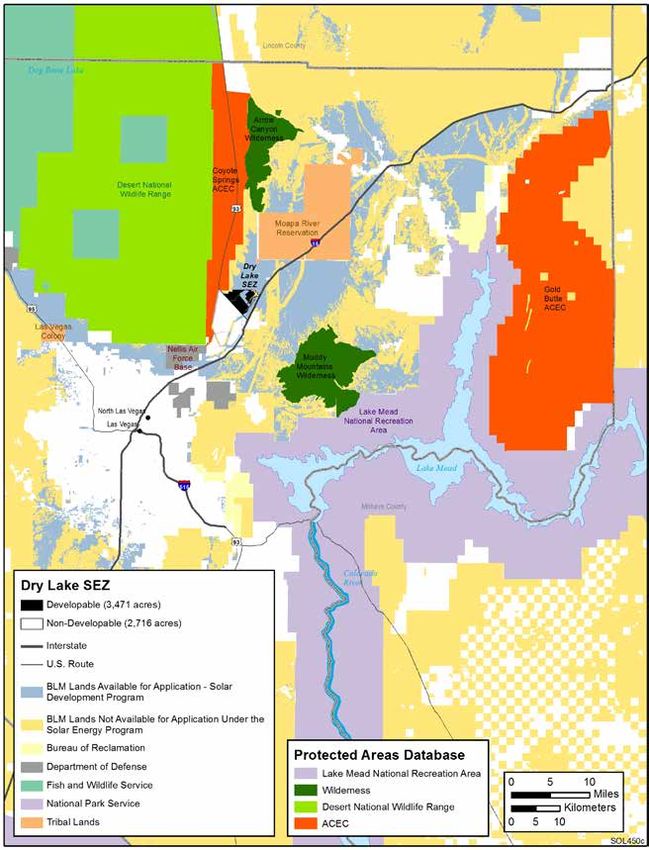
TABLE OF CONTENTS
ABSTRACT____________________________________________________________________________________ 1
1. INTRODUCTION AND PURPOSE_______________________________________________________________ 2
   1.1 Purpose of the Strategy_______________________________________________________________________ 2
   1.2 Background______________________________________________________________________________ 3
   1.3 Solar Regional Mitigation Strategy Process___________________________________________________________ 4
   1.4 Stakeholder Involvement in the Solar Regional Mitigation Strategy Process________________________________________ 5
2. MITIGATION STRATEGY – DRY LAKE SOLAR ENERGY ZONE__________________________________________ 6
   2.1 Description of the Dry Lake Solar Energy Zone and Surrounding Region__________________________________________ 6
        2.1.1 General Description of the Solar Energy Zone______________________________________________________ 6
        2.1.2 Landscape Conditions of the Solar Energy Zone and the Region___________________________________________ 6
        2.1.3 Regional Setting_______________________________________________________________________ 8
		            2.1.3.1 General Description________________________________________________________________ 8
		            2.1.3.2 Problematic Regional Trends___________________________________________________________ 8
   2.2 General Description of Solar Development in the Dry Lake Solar Energy Zone______________________________________ 18
        2.2.1 Description of Existing Rights-of-Way and Impact on Developable Area_____________________________________ 18
        2.2.2 Description of Potential Development_________________________________________________________ 18
   2.3 Summary of Solar Development Impacts on the Dry Lake Solar Energy Zone______________________________________ 19
   2.4 Mitigation Strategy (Hierarchy) of the Dry Lake Solar Energy Zone_____________________________________________ 20
        2.4.1 Avoidance__________________________________________________________________________ 20
		            2.4.1.1 Dry Wash/Riparian Areas____________________________________________________________ 20
		            2.4.1.2 Existing Rights-of-Way, Mining Claims, etc._________________________________________________ 20
        2.4.2 Minimization________________________________________________________________________ 21
		            2.4.2.1 Summary of Programmatic Design Features to be Applied________________________________________ 21
		            2.4.2.2 Other Required Impact Minimization Measures and/or Stipulations___________________________________ 21
        2.4.3 Regional Mitigation____________________________________________________________________ 21
		            2.4.3.1 Identification of Unavoidable Impacts____________________________________________________ 22
		            2.4.3.2 Unavoidable Impacts that May Warrant Regional Mitigation_______________________________________ 23
			                    2.4.3.2.1 Conceptual Models__________________________________________________________ 23
			                    2.4.3.2.2 Unavoidable Impacts that May Warrant Regional Mitigation_________________________________ 23
   2.5 Regional Mitigation Goals____________________________________________________________________ 24
        2.5.1 Background on Regional Goals______________________________________________________________ 24
        2.5.2 Las Vegas Resource Management Plan Goals and Objectives____________________________________________ 24
        2.5.3 Dry Lake Solar Energy Zone Mitigation Goals and Objectives____________________________________________ 25
   2.6 Calculating the Recommended Mitigation Fee for the Dry Lake Solar Energy Zone___________________________________ 26
   2.7 Management of Solar Regional Mitigation Fees________________________________________________________ 28
   2.8 Evaluation of Mitigation Locations, Objectives, and Actions_________________________________________________ 29
   2.9 Mitigation Effectiveness Monitoring and Adaptive Management Plan__________________________________________ 35
   2.10 Implementation Strategy_____________________________________________________________________ 43
REFERENCES_________________________________________________________________________________ 45
APPENDIX A: Impact Assessment Summary Table___________________________________________________________ 46
APPENDIX B: Regional and Dry Lake Solar Energy Zone Conceptual Models____________________________________________ 51
APPENDIX C: Summary Table: Impacts that May Warrant Regional Mitigation for the Dry Lake Solar Energy Zone_____________________ 54
APPENDIX D: BLM Screening of Candidate Regional Mitigation Sites for the Dry Lake Solar Energy Zone__________________________ 57
APPENDIX E: Mitigation of Visual Resource Impacts in the Dry Lake Solar Energy Zone_____________________________________ 63

                       REGIONAL MITIGATION STRATEGY FOR THE DRY LAKE SOLAR ENERGY ZONE • TECHNICAL NOTE 444 • iii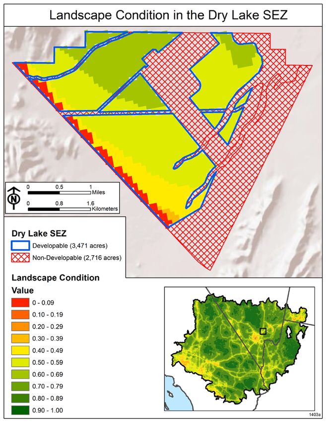
Figures
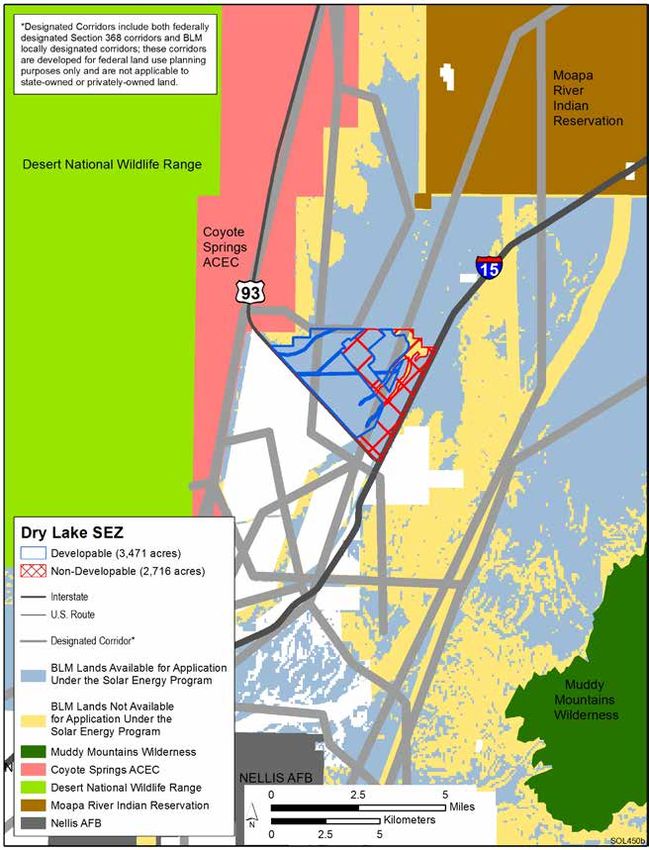
2-1 Dry Lake Solar Energy Zone and surrounding area______________________________________________ 7
2-2 Landscape condition in the Mojave Basin and Range ecoregion___________________________________ 9
2-3 Landscape condition in the Dry Lake Solar Energy Zone_________________________________________ 10
2-4 Dry Lake Solar Energy Zone and surrounding land designations__________________________________ 11
2-5 Land cover types in the Mojave Basin and Range ecoregion______________________________________ 12
2-6 Land cover types in the vicinity of the Dry Lake Solar Energy Zone________________________________ 13
2-7 Conceptual diagram for estimating condition and trends of
conservation elements in the Mojave Basin and Range ecoregion
for the Dry Lake Solar Energy Zone Solar Regional Mitigation Strategy_____________________________ 15
2-8 Dry Lake Solar Energy Zone revised developable area___________________________________________ 20
2-9 Steps for calculating per-acre regional mitigation fees__________________________________________ 26
2-10 Gold Butte Area of Critical Environmental Concern_____________________________________________ 31
2-11 Example of a stratified, nonbiased sampling schema for the Dry Lake Solar Energy Zone______________ 40
2-12 Example of a stratified, nonbiased sampling schema for the Gold Butte Area
of Critical Environmental Concern___________________________________________________________ 41
Tables
2-1 Ecological stressor source, site-impact scores, and distance decay scores implemented
for the landscape condition model for the Mojave Basin and Range________________________________ 8
2-2 Land cover types and amounts in the vicinity of the Dry Lake Solar Energy Zone_____________________ 14
2-3 Condition and trends assessment for coarse and fine filter conservation elements
in the Mojave Basin and Range relevant to the Dry Lake Solar Energy Zone_________________________ 16
2-4 Estimate of funding needed for management activities to ensure effectiveness and durability__________ 27
2-5 Dry Lake Solar Energy Zone goals and objectives associated with mitigation
in the Gold Butte Area of Critical Environmental Concern________________________________________ 32
2-6 Priority/order of Gold Butte Area of Critical Environmental Concern
mitigation goals and objectives____________________________________________________________ 34
2-7 Recommended methods and measurements for core and contingent indicators.____________________ 37
2-8 Quantitative indicators and measurements relevant to each
of the three rangeland health attributes______________________________________________________ 38
iv • REGIONAL MITIGATION STRATEGY FOR THE DRY LAKE SOLAR ENERGY ZONE • TECHNICAL NOTE 444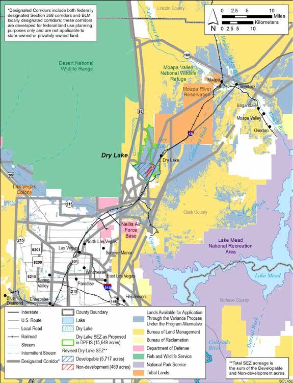
ABSTRACT

T         he “Regional Mitigation
          Strategy for the Dry
          Lake Solar Energy Zone”
          presents a strategy for
                                         Impact Statement (PEIS) for
                                         Solar Energy Development in
                                         Six Southwestern States.” The
                                         strategy consists of preliminary
                                                                                       mitigation fee could be calculated;
                                                                                       and (4) how the impacts and
                                                                                       mitigation actions could be
                                                                                       monitored. While this pilot strategy
compensating for the unavoidable         findings and recommendations                  for the Dry Lake SEZ is not a Bureau
impacts that are expected from           for conducting each element of                of Land Management decision,
the development of the Dry Lake          a process that identifies: (1) the            it will inform future decision
Solar Energy Zone (SEZ) in southern      unavoidable impacts of utility-               documents for: configuration of
Nevada. This strategy responds to        scale solar development in the                lease parcels within the Dry Lake
a call for the development of solar      Dry Lake SEZ that may warrant                 SEZ; lease stipulations; impacts to
regional mitigation strategies for       regional mitigation; (2) mitigation           be mitigated in the region; where
each of the SEZs, as committed to        actions that can be implemented               and how regional mitigation will
in the record of decision for the        in the region to compensate for               occur; and how monitoring and
“Final Programmatic Environmental        those impacts; (3) how a regional             adaptive management will occur.

                   REGIONAL MITIGATION STRATEGY FOR THE DRY LAKE SOLAR ENERGY ZONE • TECHNICAL NOTE 444 • 1
1. INTRODUCTION AND PURPOSE

1.1 Purpose of the Strategy

T         he “Regional Mitigation
          Strategy for the Dry
          Lake Solar Energy Zone”
          recommends a strategy
                                               between resources, ecosystem
                                               functions, ecosystem services,
                                               and change agents (including
                                               development, climate change,
                                                                                             what will happen if the actions
                                                                                             are not achieving the desired
                                                                                             results.

for compensating for certain                   wildfire, etc.).                             This pilot strategy will guide
unavoidable impacts that are                                                            future decisions for:
expected from the development             4. The unavoidable impacts that,
of the Dry Lake Solar Energy Zone            in consideration of regional               • The configuration of lease
(SEZ) in southern Nevada. The                trends and roles the impacted                parcels within the Dry Lake SEZ.
Bureau of Land Management (BLM)              resources play, may warrant                • The lease stipulations to achieve
is required to manage the public             regional mitigation.                         avoidance and minimization of
lands in a manner that will protect                                                       impacts.
the quality of ecological and             5. The regional mitigation goals              • The impacts to be mitigated in
environmental values and provide             and objectives recommended                   the immediate region.
for wildlife habitat in a way that           for the Dry Lake SEZ.                      • Where and how regional
does not result in the permanent                                                          mitigation will occur.
impairment of the productivity of         6. The regional mitigation                    • Monitoring and adaptive
the land. While the BLM places a             locations and action(s)                      management.
priority on mitigating impacts to            recommended for achieving the              • Developing BLM policy to guide
an acceptable level onsite, there            mitigation goals and objectives              regional mitigation.
are times when onsite mitigation             for the Dry Lake SEZ.
alone may not be sufficient. In these                                                        The BLM authorized officer
cases, which are likely to occur with     7. The estimated cost of the                  will make these decisions prior
utility-scale solar development,             mitigation action(s), including            to leasing and will also take into
which often involves a long-term             a breakout of acquisition,                 consideration:
commitment of resources over                 restoration, and/or ongoing
a relatively large area, the BLM             management costs to ensure                 • The National Environmental
is considering requirements for              effectiveness and durability.                Policy Act (NEPA) analysis
regional mitigation for those                                                             done for the proposed action,
unavoidable impacts that could            8. A recommended method for                     including comments submitted
exacerbate problematic regional              calculating a mitigation fee that            by the public and other
trends. Accordingly, this pilot              could be assessed to developers              stakeholders.
strategy articulates:                        and an explanation of how it               • Any changes to the applicable
                                             was calculated for the Dry Lake              resource management plan
1. The unavoidable impacts                   SEZ.                                         (RMP) or other plans that affect
   expected as a result of                                                                management of the SEZ or
   development of the Dry Lake            9. A recommendation for how the                 possible mitigation sites.
   SEZ.                                      BLM fee revenue derived from               • The input received from
2. The problematic trends in the             development of the Dry Lake                  consultation with tribes.
   Mojave Desert, where the Dry              SEZ could be managed.                      • Any other information that
   Lake SEZ is located.                                                                   would update, correct, or
                                          10. A recommendation for how                    otherwise supplement the
3. A conceptual model that                    the outcomes of the mitigation              information contained in this
   depicts the relationships                  actions could be monitored and              strategy.

                    2 • REGIONAL MITIGATION STRATEGY FOR THE DRY LAKE SOLAR ENERGY ZONE • TECHNICAL NOTE 444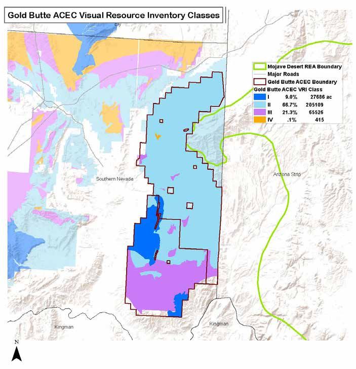
1.2 Background
I     n 2012, the BLM and the
      U.S. Department of Energy
      published the “Final
      Programmatic Environmental
                                                                      publication of the Supplement to
                                                                      the Draft Solar PEIS and the Final
                                                                      Solar PEIS to foster stakeholder
                                                                      engagement. A framework for
                                                                                                             to avoid as many conflicts as
                                                                                                             possible. Avoidance is also used
                                                                                                             within the boundaries of SEZs
                                                                                                             by designating nondevelopable
Impact Statement (PEIS) for                                           regional mitigation planning was       areas. Minimization involves the
Solar Energy Development in Six                                       included in the Final Solar PEIS and   implementation of design features
Southwestern States” (Final Solar                                     the Solar PEIS ROD. Concurrent with    (which are required mitigation
PEIS). The Final Solar PEIS assessed                                  the development of this strategy,      measures) and management
the impact of utility-scale solar                                     the BLM has developed a technical      practices meant to reduce the
energy development on public                                          reference, titled “Procedural          impacts onsite. As a part of the
lands in the six southwestern                                         Guidance for Developing Solar          analysis, the Final Solar PEIS
states of Arizona, California,                                        Regional Mitigation Strategies,” to    included a robust suite of design
Colorado, Nevada, New Mexico,                                         provide guidance on the process        features in the BLM’s solar energy
and Utah. The “Approved Resource                                      and a refined framework to aid in      program that will be employed to
Management Plan Amendments/                                           the preparation of solar regional      minimize some of the expected
Record of Decision (ROD) for                                          mitigation strategies (SRMSs) for      impacts of development onsite.
Solar Energy Development                                              other SEZs (BLM forthcoming).          The Final Solar PEIS analyzed,
in Six Southwestern States”                                                The BLM’s policy is to mitigate   and the Solar PEIS ROD adopted,
(Solar PEIS ROD) implemented                                          impacts to an acceptable level         both programmatic and SEZ-
a comprehensive solar energy                                          onsite whenever possible               specific design features. These
program for public lands in those                                     through avoidance, minimization,       design features will be included as
states and incorporated land use                                      remediation, or reduction of           stipulations in right-of-way leases
allocations and programmatic                                          impacts over time. The use of          for SEZs.
and SEZ-specific design features                                      regional mitigation is evaluated            This SRMS addresses the final
into land use plans in the six-state                                  by the BLM on a case-by-case           tier of the mitigation hierarchy,
study area (BLM 2012). The Solar                                      basis and is based on the need         specifically compensatory
PEIS ROD identified 17 priority                                       to address resource issues that        mitigation, hereafter referred
areas for utility-scale solar energy                                  cannot be acceptably mitigated         to as regional mitigation.
development, or SEZs. The Final                                       onsite. Furthermore, not all           This pilot strategy consists of
Solar PEIS presents a detailed                                        adverse impacts can or must be         recommendations to mitigate
analysis of the expected impacts of                                   fully mitigated either onsite or in    some of the unavoidable impacts
solar development on each SEZ.                                        the immediate region. A certain        that remain after avoidance
     Comments on both the Draft                                       level of adverse or unavoidable        and minimization measures are
Solar PEIS and the Supplement to                                      impact may be acceptable: (1)          taken. This strategy differs from
the Draft Solar PEIS encouraged                                       when an appropriate level of           project-level compensatory
the BLM to incorporate a                                              mitigation will be conducted and       mitigation planning that has been
robust mitigation framework                                           remaining impacts do not result in     conducted in the past. In this
into the proposed solar energy                                        unnecessary or undue degradation;      pilot, compensatory mitigation is
program to address unavoidable                                        or (2) when impacts to BLM             considered in a landscape context
impacts expected in SEZs. In the                                      sensitive species or Endangered        and includes identification of
Supplement to the Draft Solar PEIS,                                   Species Act-listed species do not      mitigation goals and objectives, as
the BLM presented, as part of its                                     exceed established resource and        well as the selection of mitigation
incentives for SEZs, the concept                                      value objectives.                      actions based on the degree of
of regional mitigation planning1.                                          In order to minimize the          impact and regional conditions
A draft framework for regional                                        impacts of solar development,          and trends. This procedure for
mitigation planning was posted on                                     the BLM applies a mitigation           conducting mitigation is also
the project web page between the                                      hierarchy, consisting of avoid,        reflected in the BLM’s interim
1
                                                                      minimize, and compensate.              policy, Draft Manual Section 1794,
   In the Final Solar Energy PEIS (BLM and DOE 2012), Appendix
A, Section A.2.5, the BLM refers to solar regional mitigation plans   Implementation of this hierarchy       “Regional Mitigation,” issued on
(SRMPs). To be consistent with guidance issued in BLM Instruction     begins with the location and           June 13, 2013.
Memorandum 2013-142 (BLM 2013b), the BLM adopts the termi-            configuration of the SEZs, so as
nology of solar regional mitigation strategies (SRMSs).

                                      REGIONAL MITIGATION STRATEGY FOR THE DRY LAKE SOLAR ENERGY ZONE • TECHNICAL NOTE 444 • 3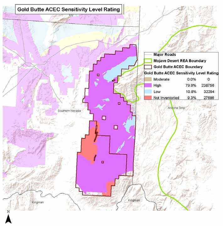
1.3 Solar Regional Mitigation
Strategy Process

I     n August 2012, the BLM
      initiated the pilot Dry
      Lake SEZ Solar Regional
      Mitigation Planning Project,
                                          comments was also extended to the
                                          public. The content and methods
                                          used in this process incorporate
                                          many of the ideas and comments
                                                                                        of Critical Environmental Concern
                                                                                        (ACEC), but for which sufficient
                                                                                        resources have been unavailable.
                                                                                        The Gold Butte ACEC is in the same
which constitutes the first SRMS          received from the public.                     ecological zone (ecoregion) and
developed for an SEZ. The Dry                 The mitigation actions                    subzone as the Dry Lake SEZ and is
Lake SEZ SRMS originated                  identified in this strategy are               of the same vegetation community.
simultaneously with, and served           designed to compensate for                    The Gold Butte ACEC provides
as a pilot test case for, the             the loss of some of the habitat,              habitat for all of the wildlife,
establishment of BLM guidance             visual resources, and ecological              including the special status species,
for developing SRMSs for other            services that are expected from               found in the Dry Lake SEZ.
SEZs (BLM forthcoming). The effort        the development of the Dry                         Under the terms of this strategy,
was conducted with a significant          Lake SEZ. For the purpose of this             funding derived from mitigation
amount of public involvement,             analysis, it is assumed that all of           fees for the Dry Lake SEZ will not
including four workshops,                 the developable land within the               be sufficient to fund all of the
several web-based meetings, and           Dry Lake SEZ will be impacted. The            potential restoration and protection
opportunities to comment on               degree of compensation will take              needs in the Gold Butte ACEC, but
preliminary and draft versions of         into consideration the condition              they will allow significant progress
methodologies and strategies.             of the resource values present in             toward achieving the management
     The Dry Lake SEZ is located          the Dry Lake SEZ and also consider            objectives for the ACEC: to preserve
about 15 mi (24 km) northeast of          the relative costs and benefits of            the extraordinary resource values
Las Vegas in Nevada. The process          the use of public lands for solar             found there while providing for
for developing the Dry Lake SEZ           energy development, including the             human use and enjoyment. As
SRMS largely followed the outline         amount of time and effort required            part of the proposed solar energy
for regional mitigation planning          to restore the disturbed area                 program, the solar long-term
outlined in the Final Solar PEIS. In      upon expiration of the lease. The             monitoring program will be used
general, a team of specialists from       recommended mitigation actions                to evaluate the effectiveness of
the BLM Southern Nevada District          are drawn from the “Proposed Las              mitigation strategies employed
Office, with the support of Argonne       Vegas Resource Management Plan                through regional mitigation plans.
National Laboratory, produced a           and Final Environmental Impact                Regional mitigation strategies will
preliminary product at each step          Statement” (Las Vegas RMP) (BLM               be subject to continued review
in the process, which was then            1998). They consist of restoration            and adjustment by the BLM and
presented and discussed in a public       and preservation measures                     its partners to ensure conservation
forum. The opportunity for written        prescribed for the Gold Butte Area            goals and objectives are being met.

                    4 • REGIONAL MITIGATION STRATEGY FOR THE DRY LAKE SOLAR ENERGY ZONE • TECHNICAL NOTE 444
1.4 Stakeholder Involvement in the
Solar Regional Mitigation Strategy Process
T he pilot process for
including stakeholder
input in developing the Dry
Lake SEZ SRMS included
October 24-25, 2012. This workshop
included a field visit to the Dry Lake
SEZ in order to give the participants
a firsthand look at the SEZ. BLM
(December 6, 2012); methods to
identify impacts that may warrant
mitigation (January 1, 2013);
and a proposed mitigation fee
four workshops in Las Vegas and staff experts were present and setting method and method to
several web-based meetings. spoke about the range of resources evaluate candidate mitigation sites
Representatives from federal, state, present in the SEZ and possible (March 21, 2013).
and local government agencies; opportunities available to avoid, All presentations from the four
nongovernmental organizations minimize, and mitigate potential workshops and three webinars are
concerned with issues such as impacts related to solar energy posted on the project documents
environmental or recreational development. web page on the Dry Lake SEZ
impacts; representatives from The third workshop was SRMS Project website at: http://
the solar development industry, held January 30-31, 2013. This www.blm.gov/nv/st/en/fo/lvfo/
mining industry, and utilities; tribal workshop focused on regional blm_programs/energy/dry_lake_
representatives; and individual trends and conditions, unavoidable solar_energy.html. Reports from
members of the public who had impacts that may warrant regional the workshops are also available.
been involved in the Solar PEIS mitigation, the establishment of Additional materials that were
process were invited to attend regional mitigation objectives, the provided for stakeholder review
these activities. Approximately 70 use of mapping tools and data in are posted on the project website
individuals and representatives choosing locations for mitigation, documents page as well.
from the previously mentioned prioritization of mitigation projects, Throughout the pilot project,
organizations attended the kickoff mitigation costing, and long-term stakeholders were invited to
workshop held August 29-30, monitoring. comment on interim draft
2012. During the first workshop, The fourth workshop, held materials, including the summary
background on regional mitigation on February 27, 2013, focused of unavoidable impacts at the
planning and the Solar PEIS impact on three topics: (1) methods for Dry Lake SEZ that may warrant
assessment for the Dry Lake SEZ establishing mitigation fees in SEZs, mitigation, the proposed method
were provided to the attendees. and specifically in the Dry Lake SEZ; for deriving the mitigation fees, the
The subsequent three workshops all (2) establishing solar mitigation method of evaluating candidate
had about 35 attendees, including objectives and priority setting; sites for mitigation, and the specific
individuals and representatives and (3) structures for holding and mitigation sites and activities
from agencies, nongovernmental applying mitigation funds. proposed for the Dry Lake SEZ.
organizations, the solar industry Additionally, several webinars Many of these comments were
and consultants to the industry, were held to provide information discussed during workshops and
utilities, and tribes. on: mitigation valuation methods used to guide development of this
The second workshop was held and mitigation structure options strategy.
REGIONAL MITIGATION STRATEGY FOR THE DRY LAKE SOLAR ENERGY ZONE • TECHNICAL NOTE 444 • 52. MITIGATION STRATEGY –
DRY LAKE SOLAR ENERGY ZONE
2.1 Description of the Dry Lake Solar
Energy Zone and Surrounding Region
2.1.1 General Description facilities. Three designated
transmission corridors pass
spatial datasets in a meaningful
timeframe. The REAs serve multiple
of the Solar Energy Zone through the area, including a purposes in an ecoregional
Section 368 energy corridor (of context, including identifying and
The Dry Lake SEZ is located in the Energy Policy Act of 2005), answering important management
Clark County in southern Nevada. which contains numerous electric questions; understanding key
The total area of the Dry Lake SEZ, transmission lines, natural gas and resource values; understanding
as shown in Figure 2-1, is 6,187 refined petroleum product lines, the influence of various change
acres (25 km2) (BLM and DOE 2012). and water lines (see Figure 2-1 for agents; understanding projected
In the Final Solar PEIS and the Solar the designated corridor). A power ecological trends; identifying and
PEIS ROD, 469 acres (1.9 km2) of generating station is also located mapping key opportunities for
floodplain and wetland within the within the area of the SEZ, and two resource conservation, restoration,
SEZ boundaries were identified existing natural gas power plants and development; and providing
as nondevelopment areas. The are located just southwest of the a baseline to evaluate and guide
developable area of the SEZ SEZ on private land. A minerals future actions.
given in the Final Solar PEIS was processing plant is located in the One useful product of the
5,717 acres (23 km2). southeastern corner of the SEZ. REAs is the development of
The towns of Moapa and The Final Solar PEIS indicated that landscape condition models.
Overton are located 18 mi (29 km) in 2012 there were three pending These geospatial models have
northeast and 23 mi (37 km) east solar applications within or adjacent been created to represent the
of the SEZ, respectively. Nellis Air to the SEZ and an additional large condition or level of intactness
Force Base is located approximately application area located about 2 mi throughout the ecoregion at the
13 mi (21 km) southwest of the SEZ. (3 km) to the east of the SEZ across time in which the assessments were
The nearest major roads accessing Interstate 15. initiated (approximately 2010).
the proposed Dry Lake SEZ are The landscape condition model
Interstate 15, which passes along is a combination of two primary
the southeastern boundary of the 2.1.2 Landscape factors—land use and a distance
SEZ, and U.S. Route 93, which runs Conditions of the decay function from land uses.
from north to south along part of Different land use categories were
the southwest border of the SEZ. Solar Energy Zone assigned a relative value between
0 and 1, representing very high
The Union Pacific Railroad runs
north to south along a portion of
and the Region landscape alteration to very little
the eastern SEZ boundary, with landscape alteration. For example,
In 2012, the BLM completed
the nearest stop in Las Vegas. The high-density urban areas received
the “Mojave Basin and Range Rapid
area around the SEZ is not highly values closer to 0, whereas intact
Ecoregional Assessment” for the
populated, although Clark County, undisturbed areas received values
Mojave Basin and Range ecoregion
with a 2008 population close to closer to 1. The distance decay
in which the Dry Lake SEZ is located
2 million individuals, has a large function considered the proximity
(NatureServe 2013). The Mojave
number of residents. of each location to human land
Basin and Range REA examines
The SEZ already contains uses. Table 2-1 lists a number of
broad-scale ecological values,
rights-of-way and developed examples of land use and distance
conditions, and trends within the
areas, including energy, water, decay scores for various stressor
ecoregion by synthesizing existing
and transportation infrastructure categories in the Mojave Basin and
6 • REGIONAL MITIGATION STRATEGY FOR THE DRY LAKE SOLAR ENERGY ZONE • TECHNICAL NOTE 444Range. A full description of the The model illustrates landscape to this landscape condition model,
landscape condition model and condition values throughout the most of the impacts occur near
how it was developed can be found ecoregion (Figure 2-2). The resulting urban areas (e.g., Las Vegas) and
in the “Mojave Basin and Range map provides a composite view of along roadways. However, most
Rapid Ecoregional Assessments the relative impacts of land uses of the Mojave Basin and Range is
Final Memorandum I-3-C.” across the entire ecoregion. Darker still relatively intact. The landscape
The landscape condition green areas indicate apparently condition within the Dry Lake SEZ is
model developed for the Mojave least impacted areas (most intact) shown in Figure 2-3.
Basin and Range was developed and orange-red areas are the most
as a raster dataset of 100-m cells. impacted (least intact). According
Figure 2-1. Dry Lake Solar Energy Zone and surrounding area (Source: BLM and DOE 2012).
REGIONAL MITIGATION STRATEGY FOR THE DRY LAKE SOLAR ENERGY ZONE • TECHNICAL NOTE 444 • 72.1.3 Regional Setting Mixed Salt Desert Scrub (0.8% of
the developable area), and North
the nondevelopable area of the SEZ
include Developed, Medium – High
American Warm Desert Wash (0.4% Intensity and North American Warm
2.1.3.1 General Description of the developable area). Other land Desert Pavement (Table 2-2).
cover types expected to occur in
The Dry Lake SEZ is situated
within 5 mi (8 km) of several other
Table 2-1. Ecological stressor source, site-impact scores, and distance decay scores implemented for
federally owned or administered
the landscape condition model for the Mojave Basin and Range.
lands. The Moapa River Indian
Reservation is approximately 4 mi
Site Presumed Distance Impact
(6.4 km) northeast of the revised Ecological Stressor Source Impact Relative Decay Approaches
SEZ boundary. The Coyote Springs Score Stress Score Negligible
ACEC, which is also designated
critical habitat for the federally Transportation
threatened desert tortoise, is Dirt roads, 4-wheel drive 0.7 Low 0.5 200 m
located within 0.5 mi (0.8 km) west Local, neighborhood and connecting roads 0.5 Medium 0.5 200 m
of the SEZ. Farther west of the
Coyote Springs ACEC is the U.S. Secondary and connecting roads 0.2 High 0.2 500 m
Fish and Wildlife Service Desert Primary highways with limited access 0.05 Very High 0.1 1,000 m
National Wildlife Refuge, which is
Primary highways without limited access 0.05 Very High 0.05 2,000 m
approximately 3 mi (4.8 km) west
of the SEZ. The Muddy Mountains Urban and Industrial Development
Wilderness Area is approximately Low-density development 0.6 Medium 0.5 200 m
8 mi (12.9 km) southeast of the SEZ
Medium-density development 0.5 Medium 0.5 200 m
(Figure 2-4).
The Dry Lake SEZ is located Powerline/transmission lines 0.5 Medium 0.9 100 m
in a relatively undeveloped rural Oil/gas wells 0.5 Medium 0.2 500 m
area, bounded on the west by the
Arrow Canyon Range and on the High-density development 0.05 Very High 0.05 2,000 m
southeast by the Dry Lake Range. Mines 0.05 Very High 0.2 500 m
The topography of the land within Managed and Modified Land Cover
the SEZ is arid basin dominated
by creosote and white bursage Ruderal forest and upland 0.9 Very Low 1 0m
vegetation communities. Land Native vegetation with introduced species 0.9 Very Low 1 0m
cover types2 within the ecoregion
Pasture 0.9 Very Low 0.9 100 m
are presented in Figure 2-5. At a
more local scale, land cover types in Recently logged 0.9 Very Low 0.5 200 m
the vicinity of the Dry Lake SEZ are Managed tree plantations 0.8 Low 0.5 200 m
shown in Figure 2-6. In total, there
Introduced tree and shrub 0.5 Medium 0.5 200 m
are 10 natural land cover types
and 2 disturbance land cover types Introduced upland grass and forb 0.5 Medium 0.5 200 m
predicted to occur in the vicinity Introduced wetland 0.3 High 0.8 125 m
(i.e., within 5 mi, or 8 km) of the
Dry Lake SEZ (Table 2-2). There are Cultivated agriculture 0.3 High 0.5 200 m
three land cover types that occur
in the developable portion of the
SEZ (Table 2-2). Listed in order of 2.1.3.2 Problematic Regional Trends Range REA defines conservation
dominance, these land cover types elements as resources of
are: Sonora-Mojave Creosote-White The Mojave Basin and Range conservation concern within an
Bursage Desert Scrub (98.8% of the REA presents a framework for ecoregion. These elements could
developable area), Sonora-Mojave determining the condition and include habitat or populations
2
trend of various resource values for plant and animal taxa, such
Geospatial data for land cover types were obtained from the
Southwest Regional Gap Analysis Project (http://earth.gis.usu.edu/ and conservation elements in the as threatened and endangered
swgap/) and the California Gap land cover mapping project (http:// ecoregion. The Mojave Basin and species, or ecological systems and
gap.uidaho.edu/index.php/california-land-cover/).
8 • REGIONAL MITIGATION STRATEGY FOR THE DRY LAKE SOLAR ENERGY ZONE • TECHNICAL NOTE 444plant communities of regional types of conservation elements in functions and services in the
importance. A list of conservation the Mojave Basin and Range: ecoregion.
elements could also include other
resource values, such as highly • Coarse filter conservation • Fine filter conservation elements,
erodible soils; populations of elements, which typically include which complement the first
wild horses and burros; scenic all of the major ecosystem types set of elements by including a
viewsheds; or designated sites within the assessment landscape limited subset of focal species
of natural, historical, or cultural and represent all of the assemblages and individual
significance. There are two basic predominant natural ecosystem species.
Figure 2-2. Landscape condition in the Mojave Basin and Range ecoregion. Darker green areas indicate least impacted areas (most intact),
whereas orange-red areas are the most impacted (least intact). Also shown is the 5-mile buffer around the Dry Lake Solar Energy Zone.
REGIONAL MITIGATION STRATEGY FOR THE DRY LAKE SOLAR ENERGY ZONE • TECHNICAL NOTE 444 • 9Figure 2-3. Landscape condition in the Dry Lake Solar Energy Zone. Approximately 3,471 acres of the solar energy zone are considered eligible for
utility-scale solar energy development.
10 • REGIONAL MITIGATION STRATEGY FOR THE DRY LAKE SOLAR ENERGY ZONE • TECHNICAL NOTE 444Figure 2-4. Dry Lake Solar Energy Zone and surrounding land designations. REGIONAL MITIGATION STRATEGY FOR THE DRY LAKE SOLAR ENERGY ZONE • TECHNICAL NOTE 444 • 11
Figure 2-5. Land cover types in the Mojave Basin and Range ecoregion.

12 • REGIONAL MITIGATION STRATEGY FOR THE DRY LAKE SOLAR ENERGY ZONE • TECHNICAL NOTE 444
Figure 2-6. Land cover types in the vicinity of the Dry Lake Solar Energy Zone.

REGIONAL MITIGATION STRATEGY FOR THE DRY LAKE SOLAR ENERGY ZONE • TECHNICAL NOTE 444 • 13
Table 2-2. Land cover types and amounts in the vicinity of the Dry Lake Solar Energy Zone.                                        are the easiest to predict in a
                                                                                                                                  meaningful timeframe for SRMSs
                                                                           Acres Within Entire SEZ           Acres Within         because solar energy development
                                                Acres Within SEZ
                Description                                                  (Developable and                5-Mile Buffer
                                               Developable Area1
                                                                             Nondevelopable)2                Around SEZ3
                                                                                                                                  represents an anthropogenic
                                                                                                                                  disturbance, and the impacts of
                                                   Natural Land Cover Types                                                       human development are likely to
 Sonora-Mojave Creosotebush-White                                                                                                 affect all conservation elements
                                                       3,427 (98.8%)                    5,879 (95.0%)         83,300 (84.1%)
 Bursage Desert Scrub                                                                                                             similarly.
                                                                                                                                       Understanding the problematic
 Sonora-Mojave Mixed Salt Desert Scrub                     30 (0.8%)                         38 (0.6%)               645 (0.7%)   conservation element trends
                                                                                                                                  relevant to the Dry Lake SEZ
 North American Warm Desert Wash                           14 (0.4%)                        141 (2.3%)           2,618 (2.6%)     was accomplished through
                                                                                                                                  (1) a geospatial analysis of
 North American Warm Desert                                                                                                       available ecoregional data and
                                                                                             21 (0.3%)           1,694 (1.7%)
 Pavement
                                                                                                                                  (2) expert opinion by the BLM
 North American Warm Desert Bedrock                                                                                               interdisciplinary team. Figure 2-7
                                                                                                                 5,144 (5.2%)
 Cliff and Outcrop                                                                                                                presents a conceptual illustration
                                                                                                                                  of the geospatial framework for
 Mojave Mid-Elevation Mixed
 Desert Scrub
                                                                                                                 4,651 (4.7%)     determining the condition and
                                                                                                                                  trends of conservation elements
 North American Warm Desert Playa                                                                                    287 (0.3%)   in the ecoregion. The geospatial
                                                                                                                                  data used in this assessment are
 Inter-Mountain Basins Semi-Desert
                                                                                                                     147 (0.1%)   available publicly from open
 Shrub Steppe                                                                                                                     sources. These data include the
                                                                                                                                  BLM’s landscape condition model
 Open Water                                                                                                           1 (
Geospatial Data
1. Landscape Condition Model1
2. Habitat Suitablity Models2
3. Land Cover Types3
Characterize Distribution:
1. In the ecoregion
2. Within vicinity of the SEZ (5-mi buffer) CONDITION
3. Within SEZ developable area
Geospatial Overlay Analysis4: TRENDS/
1. Current Development Footprint5
2. 2025 Development Footprint6 FORECAST
1
The landscape condition model is available from and described in the BLM Mojave Basin and Range Rapid Ecoregional Assessment.
2
Habitat suitability models are available from the Southwest Regional Gap Analysis Project.
3
Land cover types are available from the Southwest Regional Gap Analysis Project.
4
The overlay change agent/conservation element analysis was conducted to determine geospatial trends. Geospatial data for the change agent were
overlayed with the distribution of conservation elements to determine current and future distributions of the conservation elements.
5
Geospatial data for the current human development footprint model are available from and described in the BLM Mojave Basin and Range Rapid
Ecoregional Assessment.
6
Geospatial data for the future (approximately 2025) human development footprint model are available from and described in the BLM Mojave Basin
and Range Rapid Ecoregional Assessment.
Figure 2-7. Conceptual diagram for estimating condition and trends of conservation elements in the Mojave Basin
and Range ecoregion for the Dry Lake Solar Energy Zone Solar Regional Mitigation Strategy.
human development footprints3 for geospatial trends of fine scale expected to experience a declining
and forecast trends. Trends are conservation elements (individual trend in the Mojave Basin and
understood by using the current species). In Table 2-3, coarse filter Range, as all conservation elements
and future human development conservation elements evaluated are expected to experience some
footprints to evaluate the include the Mojave Basin and level of range contraction due to
expected future distribution of the Range landscape condition model human development in the future.
conservation element relative to its and the Southwest Regional Gap Landscape condition within the
current distribution. Analysis Project modeled land cover Mojave Basin and Range is also
An example table showing the types. expected to decline in the future.
condition and trends of various The only fine filter conservation Because the Sonora-Mojave
coarse and fine filter conservation element presented in Table 2-3 Creosotebush-White Bursage
elements in the Mojave Basin and is the Mojave population of the Desert Scrub comprised the largest
Range is shown in Table 2-3. Due desert tortoise (Gopherus agassizii), portion of the Dry Lake SEZ (98.8%),
to the large number of fine scale which is listed in the table due the cumulative expected future
conservation elements that could to its threatened status under loss of this conservation element
potentially be evaluated, the BLM the Endangered Species Act and of 10.26% was considered to be
determined that a trends analysis of known presence in potentially a problematic trend among all
coarse filter land cover types would suitable habitat on the Dry Lake conservation elements relative to
be a suitable habitat-based proxy SEZ. Based on the results presented the Dry Lake SEZ.
3 in Table 2-3, it was concluded that
Geospatial data for current and future human development
footprints are described in more detail in the Mojave Basin and all conservation elements are
Range REA (NatureServe 2013).
REGIONAL MITIGATION STRATEGY FOR THE DRY LAKE SOLAR ENERGY ZONE • TECHNICAL NOTE 444 • 15Table 2-3. Condition and trends assessment for coarse and fine filter conservation elements in the Mojave Basin and Range relevant to the Dry Lake Solar
Energy Zone.
Solar Energy Zone (SEZ) Condition in the
Landscape-Ecoregional
Site-Specific Condition Vicinity of SEZ Ecoregional Trendsa
Condition
(SEZ Developable Area) (Local-Regional Status)
Coarse Filter Conservation Element: Land Cover Types
Percent Percent Percent
Percent Potential Potential Current Future
Within 5 Percent Current Future
Potential Within SEZ Distribu- Distribu- Conversion Conversion
mi Area Total Conversion Conversion
Distribu- Relative to tion (Acres) tion (Acres) to Human to Human
Description Relative to Distribu- Relative to Relative to
tion (Acres) Distribu- Within 5 Within Devel- Devel-
Distribu- tion Within Distribu- Distribu-
Within SEZ tion in mi of SEZ Mojave opment opment
tion in Ecoregion tion in tion in
Ecoregion Boundary Ecoregion (Acres) (Acres)
Ecoregion Ecoregion Ecoregion
Natural Land Cover Types
Sonora-Mojave
Creosotebush-White 3,428 0.02% 83,300 0.59% 14,085,230 34.73% 1,229,275 8.73% 1,444,510 10.26%
Bursage Desert Scrub
North American Warm
14Table 2-3 (continued).
Solar Energy Zone (SEZ) Condition in the Vicinity
Landscape-Ecoregional
Site-Specific Condition of SEZ (Local-Regional Ecoregional Trendsa
Condition
(SEZ Developable Area) Status)
Coarse Filter Conservation Element: Landscape Condition Model
Average Current Average Future Condition Average Ecoregional
Average Current Condition
Average Current Condition Condition Value Within Value Within Mojave Difference in Current and
Value Within 5 mi of SEZ
Value Within the SEZ (SD*) Mojave Basin and Range Basin and Range Future Condition
Boundary (SD*)
Ecoregion (SD*) Ecoregion (SD*) Values (%)
Landscape Condition
57.4 (5.0) 66.0 (9.4) 76.6 (13.8) 72.3 (17.3) -4.3 (5.6%)
Value
Fine Filter Conservation Element: Mojave Desert Tortoise Distribution
Potential Distribution Potential Distribution Future Conversion to
Potential Distribution
(Acres) Within 5 mi of SEZ (Acres) Within Mojave Human Development Percent Future Conversion
(Acres) Within SEZ
Boundary Ecoregion (Acres)
Mojave Desert
Tortoise Potentially
3,471 92,168 16,772,653 1,059,811 6.3%
Suitable Habitat Model
(SWReGAP)
*SD = standard deviation
REGIONAL MITIGATION STRATEGY FOR THE DRY LAKE SOLAR ENERGY ZONE • TECHNICAL NOTE 444 • 172.2 General Description of Solar Development
in the Dry Lake Solar Energy Zone
2.2.1 Description of element in common—they all have
a large solar field with reflectors or
Availability of transmission
from SEZs to load centers is an
Existing Rights-of- photovoltaic surfaces designed to important consideration for
capture the sun’s energy. The solar future development in SEZs.
Way and Impact on fields generally require a relatively For the proposed Dry Lake SEZ,
Developable Area flat land surface; only locations with several existing transmission lines,
less than 5% slope were included including a 500-kilovolt line, run
As stated in Section 2.1, the Dry as SEZs in the Final Solar PEIS. As through the SEZ. It is possible that
Lake SEZ contains many previously constructed to date, vegetation is an existing line could be used to
developed areas, including a generally cleared and solar fields provide access from the SEZ to
natural gas power plant (the Harry are fenced to prevent damage to or the transmission grid, but since
Allen Generating Station), pipelines, from wildlife and trespassers. existing lines may already be at
a gypsum mining processing In the Final Solar PEIS, full capacity, it is possible that
plant, several known mining maximum solar development of the at full build-out capacity, new
claims, and three designated Dry Lake SEZ was assumed to be transmission and/or upgrades of
transmission corridors and rights- 80% of the developable SEZ area existing transmission lines may be
of-way (including a 500-kilovolt over a period of 20 years. Although required to bring electricity from
transmission line) (Figure 2-4). the developable area has been the proposed Dry Lake SEZ to load
Subsequent to the signing refined to 3,471 acres (14 km2) (see centers. An assessment of the most
of the Solar PEIS ROD, BLM Section 2.2.1), for the purposes of likely load center destinations for
Southern Nevada District Office this assessment, it is assumed that power generated at the Dry Lake
staff revised the developable and more nondevelopment areas will SEZ and a general assessment
nondevelopable portions of the be identified in the future and that of the impacts of constructing
SEZ to take into account current only approximately 3,000 acres and operating new transmission
existing land uses on the SEZ. (12 km2) will be developed (see facilities on those load centers was
Known locations of rights-of-way, Section 2.5). In the Final Solar PEIS, provided in Section 11.3.23 of the
pipelines, and existing leases data from various existing solar Final Solar PEIS. Project-specific
and mining claims, including facilities were used to estimate analyses would also be required to
the natural gas power plant and that solar trough facilities will identify the specific impacts of new
gypsum processing plant, have require about 5 acres/megawatt transmission construction and line
been identified as nondevelopment (0.02 km2/megawatt), and other upgrades for any projects proposed
areas within the SEZ. Although types of solar facilities (e.g., within the SEZ.
the total SEZ size is the same as power tower, dish engine, and Since Interstate 15 and
that reported in the Final Solar photovoltaic technologies) will U.S. Route 93 are adjacent to the
PEIS (6,187 acres, or 25 km2), the require about 9 acres/megawatt SEZ, existing road access should be
developable area of the SEZ has (0.04 km2/megawatt). Using these adequate to support construction
been reduced from 5,717 acres land requirement assumptions, full and operation of solar facilities.
(23 km2) to 3,471 acres (14 km2) development of the Dry Lake SEZ, It is likely that no additional road
(Figure 2-8). assuming the revised developable construction outside of the SEZ
area, would allow development of would be needed.
solar facilities with an estimated
2.2.2 Description of total of between 386 megawatts
(for power tower, dish engine, or
Potential Development photovoltaic technologies) and
694 megawatts (for solar trough
Utility-scale solar facilities of
technologies) of electrical power
all technology types have a key
capacity.
18 • REGIONAL MITIGATION STRATEGY FOR THE DRY LAKE SOLAR ENERGY ZONE • TECHNICAL NOTE 4442.3 Summary of Solar Development Impacts
on the Dry Lake Solar Energy Zone
A comprehensive assessment
of the potential impacts of
solar development at the
Dry Lake SEZ was provided
of the SEZ lands, military use of the
SEZ lands, soils, water resources,
vegetation, wildlife, special
status species (both vegetation
Some potential positive impacts
of development were identified
for local socioeconomics, as well
as positive impacts in terms of
in the Final Solar PEIS (BLM and and wildlife), air quality, visual potential to reduce greenhouse gas
DOE 2012). Potential adverse resources, paleontological and emissions if solar energy produced
impacts included effects on nearby cultural resources, Native American at the SEZ would displace use of
wilderness areas, recreational use concerns, and transportation. fossil fuels.
REGIONAL MITIGATION STRATEGY FOR THE DRY LAKE SOLAR ENERGY ZONE • TECHNICAL NOTE 444 • 192.4 Mitigation Strategy (Hierarchy)
of the Dry Lake Solar Energy Zone
2.4.1 Avoidance 2.4.1.2 Existing Rights-of-Way, areas within the SEZ. The remaining
developable area of the SEZ has
Mining Claims, etc.
been reduced to 3,471 acres
2.4.1.1 Dry Wash/Riparian Areas (14 km2) (Figure 2-8). This reduction
As stated in Section 2.2.1, the in developable area of the SEZ
In the Final Solar PEIS and BLM has revised the developable also will reduce potential impacts
the Solar PEIS ROD, 469 acres and nondevelopable portions identified in the Final Solar PEIS
(1.9 km2) of floodplain and wetland of the SEZ to take into account (e.g., far fewer acres of habitat
within the SEZ boundaries were current existing land uses on the reduction will occur for vegetation
identified as nondevelopment SEZ. Known locations of rights- and wildlife species, including
areas. Avoidance of these areas will of-way, pipelines, and existing special status species). In addition,
eliminate or largely reduce adverse leases and mining claims, including an eligible archaeological site
impacts to them. the natural gas power plant and (i.e., Old Spanish Trail/Mormon
gypsum processing plant, have Road) within a right-of-way will be
been identified as nondevelopment avoided.
Figure 2-8. Dry Lake Solar Energy Zone revised developable area.
20 • REGIONAL MITIGATION STRATEGY FOR THE DRY LAKE SOLAR ENERGY ZONE • TECHNICAL NOTE 4442.4.2 Minimization identifying potential mitigation
strategies for avoiding or
Historic Places, onsite mitigation
or avoidance strategies will be
minimizing potential impacts on considered during consultation
2.4.2.1 Summary of Programmatic the congressionally designated with the BLM-Nevada state historic
Design Features to be Applied Old Spanish National Historic Trail preservation officer and affected
and also on any remnants of the tribes to minimize impacts on
The Final Solar PEIS identified National Register of Historic Places- significant cultural resources.
a comprehensive suite of required listed sites associated with the
programmatic design features Old Spanish Trail/Mormon Road
that would avoid and/or minimize that may be located within the 2.4.3 Regional Mitigation
adverse impacts to resources, either SEZ. Avoidance of the Old Spanish
onsite or through consultation/ Trail site within the southeastern Identifying the impacts of
coordination with potentially portion of the proposed SEZ is utility-scale solar development
affected entities. The programmatic recommended. that may warrant regional
design features are extensive Native American concerns: mitigation involves three steps:
and are listed in their entirety in The Moapa Band of Paiute Indians (1) identifying all the potential
Appendix A of the Solar PEIS ROD have specifically requested formal impacts; (2) identifying which
(BLM 2012). These programmatic government-to-government of the potential impacts are
design features include required contact when construction or likely to be unavoidable (i.e., the
actions to avoid or minimize land management projects are impacts that cannot be mitigated
impacts to all of the potentially being proposed on and/or near onsite by avoidance and/or the
impacted resources listed in the Muddy River, Virgin River, implementation of design features
Section 2.3. Colorado River, Arrow Canyon meant to minimize the impact);
Range, Potato Woman, and Apex and (3) identifying which of the
Pleistocene Lake. Compensatory unavoidable impacts may warrant
2.4.2.2 Other Required Impact
programs of mitigation could be regional mitigation by taking into
Minimization Measures and/or implemented to provide access consideration the condition and
Stipulations to and/or deliberately cultivate trend of the impacted resources
patches of culturally significant in the region and how they could
The Final Solar PEIS also plants within the Dry Lake SEZ be affected by the unavoidable
includes SEZ-specific design or on other public lands nearby impacts.
features for all of the SEZs. The SEZ- where tribes have ready access. As part of the Dry Lake SRMS
specific design features identified The BLM should consider assisting process, a team of specialists from
for the Dry Lake SEZ were the the Moapa Band of Paiute Indians the BLM Southern Nevada District
following: with the preparation of forms to Office (called the interdisciplinary
Water resources: Groundwater nominate identified sacred places team) reevaluated the potential
analyses suggest that full build- as traditional cultural properties, impacts of solar development that
out of dry-cooled and wet-cooled if it is found that all the proper were described in the Final Solar
technologies is not feasible; for eligibility requirements are met. PEIS (see Section 2.3) in the light
mixed-technology development Some additional minimization of available data specific to the
scenarios, any proposed dry- or measures would likely be identified SEZ area. This team, along with
wet-cooled projects should use during preparation of a NEPA other BLM subject matter experts
water conservation practices. analysis to support a competitive and Argonne National Laboratory
Wildlife (mammals): The lease offering within the SEZ. subject matter experts, followed
fencing around the solar energy These measures would also be the methodology presented in
development should not block incorporated into the lease offering Sections 2.4.3.1 and 2.4.3.2 for first
the free movement of mammals, as stipulations. For example, if identifying unavoidable impacts
particularly big game species. any archaeological sites are found from solar development in the
Cultural resources: during the cultural resource SEZ, and then for identifying the
Coordination with the trail inventory (see text box titled Dry unavoidable impacts that may
administration for the Old Lake Cultural Resources) and are warrant regional mitigation.
Spanish Trail and Old Spanish Trail determined to be eligible for
Association is recommended for listing in the National Register of
REGIONAL MITIGATION STRATEGY FOR THE DRY LAKE SOLAR ENERGY ZONE • TECHNICAL NOTE 444 • 21Dry Lake Cultural Resources
Following the process for evaluating cultural resources outlined in Appendix E of the BLM technical reference, titled “Procedural Guidance for
Developing Solar Regional Mitigation Strategies” the BLM interdisciplinary team determined cultural resources at the Dry Lake SEZ could most
likely be mitigated onsite and would not require regional mitigation.
At the time of the pilot Dry Lake SEZ Solar Regional Mitigation Planning Project, a relatively high percentage of the Dry Lake SEZ (well over 20%)
had been previously surveyed and/or had been previously disturbed during other industrial activities (e.g., power generation, transmission,
mining/milling) with few known sites recorded. A segment of the Old Spanish Trail/Mormon Road (not identified as part of the congressionally
designated national historic trail) was previously evaluated and determined significant; it is listed as part of a National Register historic district.
Because of its proximity to two washes already established as avoidance areas and a set of existing transmission line rights-of-way, it was
determined by the interdisciplinary team that any potential impacts on the cultural site (road) are “avoidable,” and no development with the
potential to impact the site would be approved in that portion of the SEZ (see Section 2.4.1.2). No other National Register-eligible sites were
known within the SEZ at the time of the pilot. An archaeological inventory of the unsurveyed portions of the SEZ is scheduled to be completed
prior to offering the SEZ for competitive lease.
In the case of the pilot, it was determined by the interdisciplinary team that a regional approach to mitigation planning did not make sense for
the Dry Lake SEZ because other SEZs would not likely benefit (not in same region) and because little cost savings and efficiency could be gained
with so little survey needed. It was also assumed that the few significant sites that might be found in the SEZ during the future inventory could
be mitigated most effectively onsite (i.e., within the SEZ) using traditional methods and in consultation with the state historic preservation
officer and tribes. The cultural resource mitigation planning for the Dry Lake SEZ was able to be stopped at this point, and it was concluded that
standard procedures for addressing cultural resource impacts made the most sense; the standard procedures would complete the inventory and
evaluation and mitigate for any significant sites within the SEZ.
In addition, consultation with the Moapa Band of Paiute Indians and other tribes had not identified archaeological/cultural resources significant
to them in the SEZ, although resources in the surrounding areas had been identified through an ethnographic study (SWCA and University of
Arizona 2011). At the time of the pilot, the BLM was still seeking clarifications from the Moapa on whether portions of the Salt Song Trail or other
traditional trails crossed the SEZ and whether cultural resource impacts of interest to the tribe were possible. This issue has not yet been resolved.
Based on feedback during the pilot Dry Lake SEZ Solar Regional Mitigation Planning Project workshops, the Moapa were most concerned about
impacts on habitat, wildlife, and water use.
2.4.3.1 Identification of impacts for each resource • The team verified/augmented
value presented in the Final the programmatic and SEZ-
Unavoidable Impacts
Solar PEIS. specific design features
The following methodology - Evaluated whether the presented in Appendix A of the
was used to identify unavoidable description of the affected Final Solar PEIS.
impacts: environment and impacts - Reviewed the programmatic
was comprehensive and and SEZ-specific design
• The interdisciplinary team accurate and whether features presented in the
verified/augmented the affected more detailed information Final Solar PEIS, determined
environment and impacts was available that could which design features
presented in the Final Solar PEIS influence the description of are applicable to the Dry
(for completeness, reviewed impacts as provided in the Lake SEZ, and determined
analysis in both the Draft and PEIS. Where applicable, new if there are additional
Final Solar PEIS). information was documented measures that could be
- Reviewed the affected (see Appendix A, Impact implemented to avoid and/
environment and the direct, Assessment Summary Table). or minimize impacts onsite.
indirect, and cumulative Where applicable, this was
22 • REGIONAL MITIGATION STRATEGY FOR THE DRY LAKE SOLAR ENERGY ZONE • TECHNICAL NOTE 444You can also read