PROPOSED EXTRACTIVE INDUSTRY YOUNGS ROAD QUARRY, CASCADE ENVIRONMENTAL IMPACT STATEMENT - Norfolk Island Regional Council September 2021
←
→
Page content transcription
If your browser does not render page correctly, please read the page content below
PROPOSED EXTRACTIVE INDUSTRY

YOUNGS ROAD QUARRY, CASCADE

ENVIRONMENTAL IMPACT STATEMENT

                               Norfolk Island Regional Council
                                             September 2021

                                                            1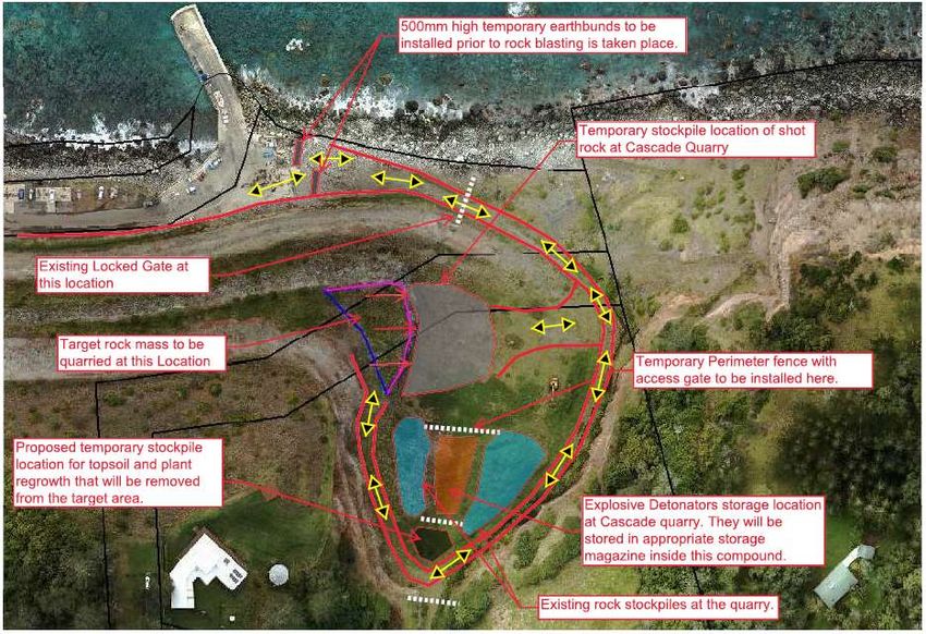
EIS – Proposed Youngs Road Quarry Cascade, September 2021

This page has been left intentionally blank

                                                                            2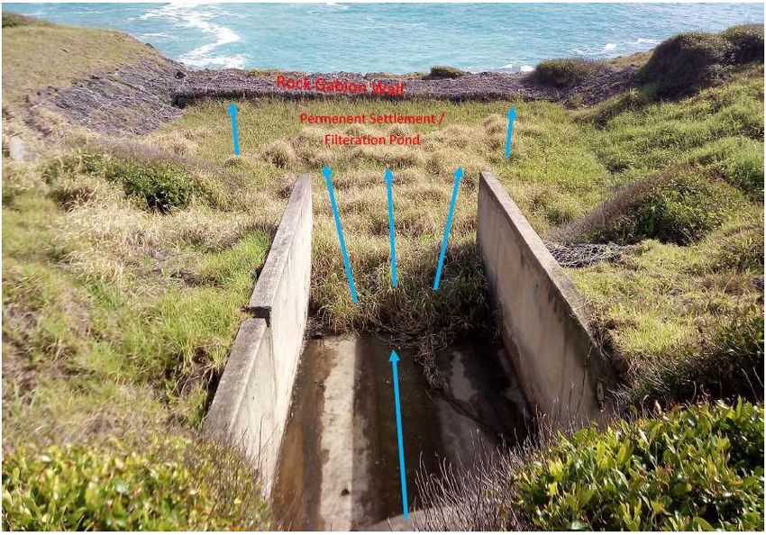
EIS – Proposed Youngs Road Quarry Cascade, September 2021
Preliminaries
This Environmental Impact Statement (EIS) is prepared in accordance with the requirements of the
Planning Act 2002 (NI) (‘the Act’) and the Planning Regulations 2004 (NI) (‘the Regulations’). Under Section
45(5)(a) of the Act, an EIS must be prepared in accordance with the requirements prescribed by Schedule
2 of the Regulations and any directions given by the Chief Executive Officer under Section 45(6) of the Act
about the assessment and statement.
The requirements prescribed in Schedule 2 of the Regulations are at Appendix A. The directions given under
section 45(6) are at Appendix B.
EIS prepared by:
Norfolk Island Regional Council
Applicant:
Norfolk Island Regional Council
PO Box 95
Norfolk Island
Proposed use or development to which the EIS relates:
Industry – Extractive: Quarry (estimated yield 13,500 tonnes)
Property description:
Proposed Quarry Site
Part of Youngs Road, described as RD 35, Section No. 10; Part of land within Cascade Reserve, described as RES,
Lot No. 28, Section Nos. 9 and 10; and Part of Portion 5a1, described as Lot 116, Section 9.
Temporary proposed bulk explosives storage site
Part of Portion 109a, described as Lot 20, Section 33.
Temporary proposed rock storage site
Part of Portion 183, described as Lot 1, Section 29.
Statement that the information contained in the statement is neither false nor misleading.
To the best knowledge of NIRC Staff that participated in the development of this EIS:
the following has been prepared in accordance with the Schedule 2 of the Planning Regulations 2004
(NI)
the document contains all available information at the time of preparing this document that is relevant
to the environmental assessment of the proposed development.
the information contained in this document is neither false or misleading.
3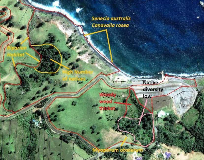
EIS – Proposed Youngs Road Quarry Cascade, September 2021

This page has been left intentionally blank

                                                                            4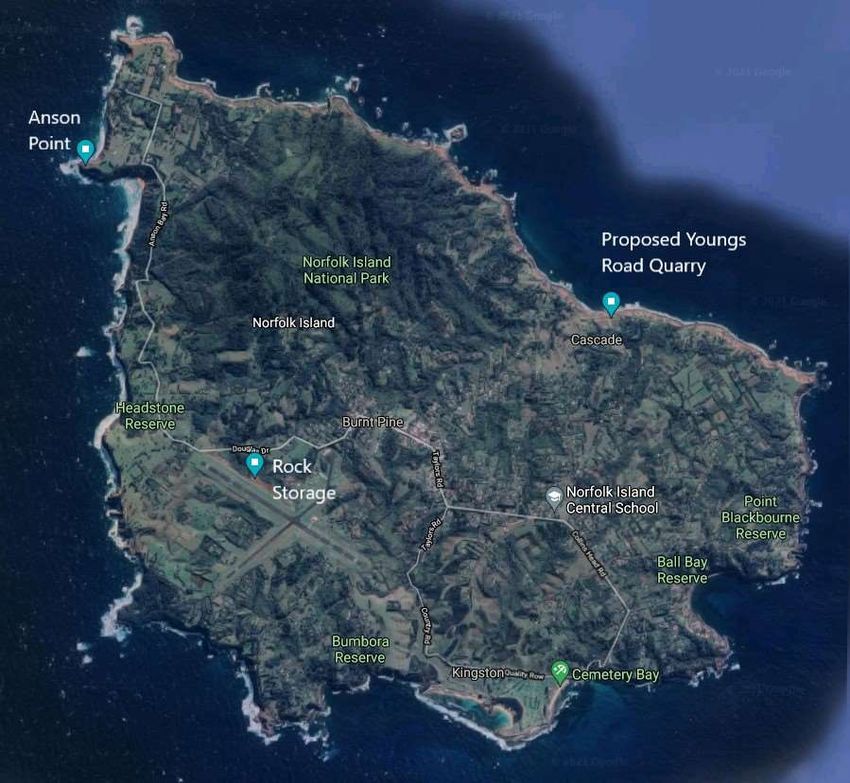
EIS – Proposed Youngs Road Quarry Cascade, September 2021

Table of Contents
PRELIMINARIES .................................................................................................................................. 3

EXECUTIVE SUMMARY ....................................................................................................................... 8

1.     INTRODUCTION ........................................................................................................................ 10

1.1.     SCOPE ...................................................................................................................................... 10
1.2.     REPORT STRUCTURE .................................................................................................................... 10
1.3.     PROJECT SITE PLAN ..................................................................................................................... 10
1.4.     INDEPENDENT DEVELOPMENT ASSESSMENT ....................................................................................... 12

2.     PROJECT DESCRIPTION............................................................................................................... 13

2.1. OBJECTIVES OF THE PROPOSAL ....................................................................................................... 13
2.2. PROJECT OVERVIEW .................................................................................................................... 13
2.3. PROJECT HISTORY ....................................................................................................................... 13
2.4. PROJECT SITES............................................................................................................................ 15
2.4.1. LOCALITY ............................................................................................................................... 15
2.4.2. LAND OWNERSHIP.................................................................................................................... 19
2.5. PROPOSED EXTRACTION AREA ........................................................................................................ 20
2.6. FEASIBLE ALTERNATIVES TO THE PROPOSED QUARRY DEVELOPMENT ........................................................ 21

3.     STRATEGIC AND STATUTORY CONTEXT ..................................................................................... 23

3.1. PLANNING ACT 2002 NI............................................................................................................... 23
3.1.1. ‘SIGNIFICANT DEVELOPMENT’ STATUS OF DA .................................................................................. 23
3.1.2. ANCILLARY ACTIVITIES ............................................................................................................... 24
3.2. NORFOLK ISLAND PLAN - STRATEGIC PLAN AND ZONING SCHEME ........................................................... 25
3.2.1. PART A – STRATEGIC PLAN ......................................................................................................... 25
3.2.2. PART B – ZONING SCHEME ........................................................................................................ 26
3.3. ENVIRONMENTAL PROTECTION AND BIODIVERSITY CONSERVATION ACT 1999 (CTH)................................... 29
3.4. HERITAGE ACT 2004 (NI) ............................................................................................................. 31
3.5. PUBLIC RESERVES ACT 1997 (NI): .................................................................................................. 32

4.     PROJECT DEVELOPMENT ............................................................................................................ 32

4.1. GENERAL MANAGEMENT .............................................................................................................. 32
4.2. QUARRY DEVELOPMENT AND OPERATION ......................................................................................... 33
4.2.1. METHOD OF BREAKING .............................................................................................................. 33
4.2.2. PROCESSING BLASTED ROCK ........................................................................................................ 34
4.3. SITE ACCESS .............................................................................................................................. 35

                                                                                                                                                      5
EIS – Proposed Youngs Road Quarry Cascade, September 2021

4.4. LAYDOWN / PARKING AREA .......................................................................................................... 36
4.5. STOCKPILES ............................................................................................................................... 36
4.6. PLANT AND EQUIPMENT ............................................................................................................... 37
4.6.1. INFRASTRUCTURE ..................................................................................................................... 37
4.7. EXPLOSIVES MANAGEMENT ........................................................................................................... 39
4.8. OUTPUT ................................................................................................................................... 40
4.9. DURATION OF THE PROPOSED EXTRACTION OPERATION ........................................................................ 41
4.10. HOURS OF OPERATION ............................................................................................................... 41

5.    CONSULTATION ......................................................................................................................... 42

6.    ENVIRONMENTAL IMPACT ASSESSMENT ................................................................................... 47

6.1.    NOISE AND BLASTING .................................................................................................................. 47
6.2.    WASTE MANAGEMENT................................................................................................................. 55
6.3.    AIR QUALITY AND HUMAN HEALTH ................................................................................................. 56
6.4.    WATER .................................................................................................................................... 57
6.5.    LAND ....................................................................................................................................... 59
6.6.    TRAFFIC AND TRANSPORT.............................................................................................................. 59
6.7.    HAZARDS AND RISK .................................................................................................................... 64
6.8.    BIODIVERSITY............................................................................................................................. 67
6.9.    VISUAL IMPACTS ......................................................................................................................... 73
6.10.    HERITAGE ............................................................................................................................... 76
6.11.    SOCIAL AND ECONOMIC .............................................................................................................. 80
6.12.    REHABILITATION ....................................................................................................................... 81
6.13.    CUMULATIVE IMPACTS ............................................................................................................... 86

7.    SUMMARY OF MITIGATION MEASURES ...................................................................................... 86

8.    JUSTIFICATION .......................................................................................................................... 90

REFERENCES..................................................................................................................................... 93

APPENDICES..................................................................................................................................... 94

                                                                                                                                                     6
EIS – Proposed Youngs Road Quarry Cascade, September 2021

Table of Figures
Figure 1 – Proposed project sites, including quarry, explosives storage (Anson Point) and rock storage
(Norfolk Island Airport) .................................................................................................................................11
Figure 2 – Proposed quarry site in broad context ........................................................................................12
Figure 3 – Modelled Quarry, (Boral 2019) ....................................................................................................15
Figure 4 – Site for proposed quarry and surrounding land use and activities ..............................................16
Figure 5 – Survey Plan prepared in 2015 showing Cascade Road, Pier, Access Track, former Quarry and
house on adjacent allotment ........................................................................................................................17
Figure 6 – Bulk Explosive Storage location, Anson Point ..............................................................................18
Figure 7 – Rock Storage location, Norfolk Island Airport Precinct................................................................19
Figure 8 – Proposed Extraction Area (Source: BCA Consulting 2018)...........................................................20
Figure 9 – Aerial view of the proposed extraction area, temporary stockpile and detonator storage. .......21
Figure 10 – Extract Part A - Strategic Plan – Activity Node Preferred Dominant Land Use - Proposed Quarry
Site ................................................................................................................................................................26
Figure 11 – Extract Zoning Scheme, Proposed Quarry Site ..........................................................................27
Figure 12 – Traffic control point at Harpers Road / Cascade Road intersection ..........................................36
Figure 13 – Existing permanent settlement/filtration pond on site. ............................................................38
Figure 14 – Proposed water runoff diagram for the proposed quarry. ........................................................39
Figure 16 – Blast Face ...................................................................................................................................51
Figure 17 - Distances to Sensitive Receivers .................................................................................................52
Figure 18 - Blast monitoring locations at nearby residences........................................................................54
Figure 19 – Rock hauling route through Cascade Jetty area ........................................................................61
Figure 20 – Transport route from proposed quarry site, through Middlegate and Burnt Pine, to the
stockpile/laydown site at the Airport (4 photos)..........................................................................................63
Figure 21 – Extract from 2017 Survey of Cascade Reserve, courtesy of Dr Kevin Mills. ..............................68
Figure 22 – Photograph showing highly modified state of subject site including an engineered batter
(foreground) and previously quarried rock face (background) (Christian 2017) ..........................................74
Figure 23 – Photograph showing previously quarried rock face and engineered bench (within subject site),
and background area (outside subject site) still retaining scenic amenity values (Christian 2017) .............75
Figure 24 – Varman Archaeological Zoning Plan: Phillipsburg/Cockpit Historic Site, Part 1 Historical, 1998.
The enclosed dotted areas are areas zoned as of high significance. The numbers refer to individual sites.
 ......................................................................................................................................................................78
Figure 25 – Aerial view of proposed site and locations of nearby items of heritage (image: Google Maps,
accessed 28/10/20).......................................................................................................................................79
Figure 26 - Fill plan, Cascade Quarry.............................................................................................................84
Figure 27 - Fill sections, Cascade quarry. ......................................................................................................85

List of Tables
Table 4-1 – Hours of Quarry Operation……………………………………………………………………..………………….. 41
Table 5-1 – Consultation with Stakeholders……………………..…………………………………………………………… 42
Table 6-1 – Predicted Noise Impacts – Proposed Quarry..…………………………………………………………….. 49
Table 6-2 – Vibration and Air Blast Monitoring….…………………………………………..…………………………….. 53
Table 6-3 – Fauna species that are likely to be found within the surrounding area of the proposed
Cascade Quarry……………………………………………………………..……………………………………………………………… 70

                                                                                                                                                                       7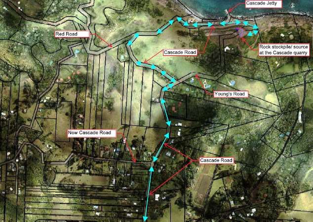
EIS – Proposed Youngs Road Quarry Cascade, September 2021
Executive Summary
The proposed Youngs Road quarry is a small-scale hard rock extraction with a maximum potential yield
of 13,500 tonnes. The purpose of the quarry is to supply hard rock for local road maintenance and
construction, with approximate demand of 7,000 tonnes/year. On this basis, the yield from the
proposed quarry would provide approximately 2 years of demand for local needs.
The proposed extraction area is described as -
Part of Youngs Road, described as RD 35, Section No. 10; zoned ‘Road’ in the Norfolk Island Plan
2002 (‘the Plan’);
Part of land within Cascade Reserve, described as RES, Lot No. 28, Section Nos. 9 and 10; zoned
‘Open Space’ in the Plan; and
Part of Portion 5a1 (part of the former quarry), described as Lot 116, Section 9, zoned ‘Rural’ in
the Plan.
Ancillary activities to the proposal include the temporary storage of bulk explosive material at Anson
Point near the Norfolk Island Gun Club, to comply with segregated storage arrangements identified in
Australian Standard 2187.1, and the storage of quarried material at land adjacent to and downslope
from the Norfolk Island Airport Runway 11 and previously used for stockpiling of rock for the Airport
runway upgrade.
The proposed development was declared ‘significant development’ as the proposal complies with the
matters to be considered in Section 28D(2)(a)-(e) of the Planning Act 2002 (NI). The proposal has
potential to deliver various economic benefits to the broad Norfolk Island community; and to provide
a supply of rock on Island to process into rock products locally and maintain reasonable costs to
support local industry.
The proposed activity complies with and is consistent with the objectives and intent of the Norfolk
Island Plan 2002 as the proposed quarry site is within the Cascade ‘Activity Node Preferred Dominant
Land Use Area’ which is intended to provide for the necessary and essential industrial and
infrastructure functions on Norfolk Island. As an industrial activity and a form of public infrastructure,
the proposed quarry is a development type to be encouraged in the Activity Node Preferred Dominant
Land Use area.
Land adjacent to the proposed extraction area is within Cascade Reserve and listed in the Norfolk
Island Heritage Register. A Heritage Impact Statement was prepared to assess the potential impact of
the proposed development on the heritage values of Cascade Reserve. This concluded that the
potential impact from the development is acceptable given that the proposed location is at the edge
of Cascade Reserve and adjacent to the former quarry and therefore visually will not alter the existing
landscape and fabric in a way that is detrimental to the scenic quality and character of Cascade
Reserve or its associated heritage values.
The environmental assessment indicates the most significant impacts from the proposal would be
generated by blasting. This activity would generate noise, ground vibration, dust and potential for fly
rock. The assessment indicates that the blasting activities can be managed to minimise the potential
impacts and meet the proposed acceptance criteria for noise and vibration with the adoption of
mitigation measures such as those identified.
8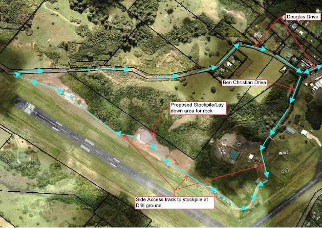
EIS – Proposed Youngs Road Quarry Cascade, September 2021

Generally, the proposed quarry activities would not generate additional traffic that would have an
impact on the surrounding road network. However, during times when the broken rock is transported
to the temporary stockpile site at land adjacent to Runway 11 (Portion 183 (Lot 1/Section 29) the
volumes of additional truck traffic would be relatively high. It is estimated there would be up to forty
(40) return truck trips per day. Quarried rock would be hauled over a continuous period so that all
rock is removed from the quarry site. It is proposed that a traffic management plan would be prepared
for the quarry to ensure public safety, particularly during the hauling periods when there may be
potential conflicts between traffic generated by quarry activities and activities at Cascade Jetty when
ships are in port.

The proposed quarry activity has the potential to generate hazards as identified in Section 5.6. The
assessment indicates that there are various mitigation measures that could be applied to minimise
the risks and negative impacts generated by potential impacts. It is expected that mitigation measures
appropriate for the specific project details, such as the blasting design, would be applied and enforced
through an environmental management plan to guide the operation of the quarry.

It is not expected that the proposed quarry operation would have an appreciable impact on local air
quality given the small scale and short duration of the operation. Measures to minimise the spread of
dust would be applied such as avoiding dust generating activities when weather conditions are
unsuitable and regular application of water for dust suppression.

The existing drainage system in place that serves the former quarry has been assessed and determined
to be in a good and functional state. The system is suitable to manage runoff and control sediment
and to prevent contaminated or silty runoff escaping the site.

The subject land and surrounding area is significantly modified compared to its natural state as a result
of the benching of Cascade Cliff in 1999-2000, which was completed to stabilise the cliff face and the
site of the former quarry. There are no remaining outstanding, rare, unusual or otherwise important
landscape features or landforms present at the subject site. There is no significant flora or fauna in
the area and the assessment concludes that the proposed quarry activity would not have a negative
impact on threatened species or ecological communities.

The assessment concludes that on balance, the proposed quarry operation would create economic
benefit for the community. The proposal is relatively low-scale and short term and has the potential
to supply rock for general public works and for the local construction industry. There is currently no
regular supply of rock for construction available on Norfolk Island and the proposal has the potential
to ensure a regular supply of rock for approximately two years while longer term rock sources are
investigated and secured.

The environmental assessment indicates that the proposed quarry could operate in a manner that
would not have significant or long-term negative impacts on the biophysical or human environment,
provided that the appropriate standards and measures to mitigate potential impacts, such as those
identified in this assessment, are applied. The detailed methodology to blast the proposed quarry
would be developed by the successful contractor. While mitigation measures have been put forward
in this EIS, the operational procedures, confirmed mitigation measures and rehabilitation design
would be detailed in an environmental management plan to be developed should the proposal be
approved.

It is concluded that the operation of the Youngs Road quarry as generally proposed in this EIS would
provide significant benefits for the Norfolk Island community and its development and operation is in
the public interest.

                                                                                                           9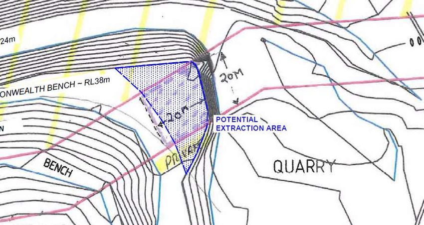
EIS – Proposed Youngs Road Quarry Cascade, September 2021
1. Introduction
1.1. Scope
Norfolk Island Regional Council (NIRC) is seeking development approval for development of a quarry
at Youngs Road, Cascade, Norfolk Island. This Environmental Impact Statement (EIS) is prepared under
section 45 of the Planning Act 2002 (NI) (‘the Act’) and is intended to provide information on the
project including potential environmental impacts and mitigation measures to manage potential
impacts. The EIS is intended to inform the community on the proposed development and facilitate
determination of the development application (DA) and development consent conditions.
This EIS describes the proposal, including quarry establishment, rock extraction, processing, product
transportation and rehabilitation. The quarry is proposed to be managed and operated in a manner
that meets acceptable environmental standards and would provide social and economic benefits for
the Norfolk Island community through the supply of rock for construction.
The proposal has been declared as Significant Development under section 28C of the Planning Act
2002 (NI). As such this EIS is required to consider the matters listed under Schedule 2 of the Act,
‘Matters to be included in Environmental Statement’ (Appendix A). In addition, the EIS considers the
matters listed in the ‘Chief Executive Officer Directions for Environmental Impact Statement’ which
was prepared under Section 45(6) of the Act by Port Macquarie Hastings Council specifically for this
project (Appendix B).
1.2. Report Structure
The key sections of this report and areas where specialist reports have been utilised (see also
Appendices) are as follows:
Project description
Strategic and statutory context
Detailed Project description
o Investigation into Cascade Cliff and Review of Alternative Sites (Boral 2019)
o Cascade Quarry Development Options and Alternative Quarry Rock Option (BCA
Consulting 2018)
Community consultation
Environmental Impact Assessment
o Ecological assessment Cascade Quarry (Castles 2020)
o Heritage Impact Statement Proposed Extractive Industry Youngs Road / Cascade Reserve
Norfolk Island (Evans 2020)
o Blast Management Plan (Donnelly 2021a)
o Blast Design (Donnelly 2021b)
Summary of mitigation measures
Justification
1.3. Project Site Plan
The proposed quarry site is located in the north-east of the island, adjacent to the Cascade Bay area
(Figures 1 and 2). The proposed sites for the ancillary activities, storage of bulk explosives at the Anson
10EIS – Proposed Youngs Road Quarry Cascade, September 2021
Point in the north west of the Island and temporary rock storage adjacent to Runway 11 at the Airport
are also shown on Figure 1.
Figure 1 – Proposed project sites, including quarry, explosives storage (Anson Point) and rock storage (Norfolk Island
Airport)
11EIS – Proposed Youngs Road Quarry Cascade, September 2021
Figure 2 – Proposed quarry site in broad context
1.4. Independent Development Assessment
NIRC is the majority landowner of the proposed quarry site and is the proponent for the proposed
development. NIRC also owns the land where the off-site ancillary activities are proposed at Anson
Point and Norfolk Island Airport. To provide an impartial assessment of the proposal, a third-party will
perform the role of General Manager prescribed in the Act. Shortly after the quarry proposal was
declared Significant Development by the Minister, NIRC engaged Port Macquarie Hastings Council
(PMHC) to perform the task of independent assessment agency. It is noted that NIRC previously had
a Memorandum of Understanding (MoU) with PMHC for reciprocal matters including assessment of
planning proposals. PMHC subsequently provided a list of matters to be addressed by the General
Manager in preparing the EIS, referred to as the Chief Executive Officer Directions for Environmental
Impact Statement. These matters are provided in Appendix B.
Subsequent to issuing the Chief Executive Officer Directions for Environmental Impact Statement,
PMHC advised they were unable to conduct an assessment of the EIS in the requested timeframe. On
this basis, an independent third-party planning consultant, Planning Assist, has been engaged as the
independent assessor for the proposed quarry development. This consultant will provide an
assessment report directly to the Minister (or their delegate) for consideration, including an
assessment of this EIS, a recommendation on whether the proposal should be approved and, should
the project be approved, a set of draft conditions that would accompany the approval.
12EIS – Proposed Youngs Road Quarry Cascade, September 2021
2. Project Description
2.1. Objectives of the Proposal
There is currently no reliable and regular supply of rock for general Island requirements and there
is an acknowledged shortage of processed rock on Island. The Youngs Road Site is being assessed
as a potential source of rock to supply the Island’s general rock requirements.
There are very limited sources of rock currently available in Norfolk Island in the short term, so it
is vitally important for this proposal to be executed to meet current demands for construction,
general public works and maintenance requirements.
The long-term plan is to find another source of rock on the Island to supply the future needs of the
community instead of an expensive option to import rock from mainland Australia. Potential new
sources of rock on the Island are currently being investigated and if found suitable, a new rock
quarry will be developed to meet the future needs of the community.
The proposal could provide an on-Island supply of quality rock for local construction and general
Island needs. A local supply of rock would assist in controlling the price of rock and supporting the
affordability of building and development and construction.
The on-going supply and availability of rock is critical to the economy of Norfolk Island. On –Island
extraction of rock would contribute to the local economy by generating jobs in extraction,
transport and rock processing.
Although the anticipated duration of the supply from the Youngs Road site is limited, the supply
has the potential to meet local demand while long term options for the on-going supply of rock
are investigated and determined.
The alternative to sourcing rock locally is to import rock which has been proven to be expensive
and would potentially add significantly to the costs of construction and public works on Island.
Also, current cargo handling requirements do not allow for unloading bulk rock supplies; as
described in section 2.7.
The proposal has the potential to provide time to assess the environmental and financial impacts
and merits of continuing to quarry and source rock on Island compared to importing rock products.
2.2. Project Overview
The proposed quarry extraction project has four phases:
1. Establishment and initial site development at the proposed site – including access road
regrading, drainage reinstatement and site equipment storage/establishment
2. Explosives delivery and storage at Anson Point.
3. Drilling and blasting
4. Transport of blasted rock for stockpiling at the proposed temporary stockpile site at the Airport.
2.3. Project History
A quarry has existed at Cascade since around 1970 occupying the Youngs Road Reserve and Portion
5a1 (Lot 116) – see Section 2.4.2. The first formal approval for the quarry was obtained in 1990, where
a Building Approval was issued by the Norfolk Island Administration.
In 1990 SMEC consultants were engaged to undertake a Face Stabilisation Project at Cascade Cliff
(Boral 2019). This project resulted in a sloping face (the current face) which is safe and stable and has
13EIS – Proposed Youngs Road Quarry Cascade, September 2021
an overall angle up the face of around 45 degrees. The project was to modify the cliff face to a safer
landform.
The materials sourced from the excavation were stored at Portion 44a on Cascade Road and also in
the area known as the quarry. These materials were later used as various construction materials up to
current times. This resource is virtually exhausted. Remaining materials recently inspected had the
appearance of being the tuffaceous material with small lumps of basalt mixed through. This material
is not considered economic or suitable for most uses due to the low yield expected from screening to
recover the lumps.
NIRC has been investigating alternative sites for a new quarry and engaged professional assistance to:
identify potential sites for a new quarry on Island, which identified the Youngs Road site as the
most likely option to be developed in the short term and provide rock while longer term
solutions for rock supply are investigated such as a new large scale quarry on Island; and
drill, source and test rock quality at the proposed extraction site at Youngs Road; and
design a small quarry at Youngs Road.
In October 2018 BCA Consulting Earth Resources investigated the former Cascade Quarry and other
possible quarry sites on Norfolk Island and produced the Report, ‘Cascade Quarry Development
Options and Alternative Quarry Rock Options’ (BCA Consulting 2018).
Boral Resources visited the Island in March 2019 to progress the investigations and undertook drilling,
testing of rock quality and modelling to more accurately determine the quality and quantity of rock
available at the Youngs Road site. Boral subsequently developed preliminary concepts for a Quarry
Design at the proposed site, presented in the Report ‘Investigation into Cascade Cliff and Review of
Alternative Sites’ Boral, June 2019 (Boral 2019).
The site is a ‘section’ of Cascade Cliff and described in the Boral Report as ‘a small shelf of the main
basalt flow at the southern end of the upper main bench’ that was retained during the Cascade Cliff
stabilisation project. The quantity and quality of rock has been examined and tests indicate the rock
is suitable for general construction requirements. Modelling based on available parameters and data
resulted in a small quarry shell design that would potentially allow for approximately 13,500 tonnes
of extraction.
14EIS – Proposed Youngs Road Quarry Cascade, September 2021
Figure 3 – Modelled Quarry, (Boral 2019)
2.4. Project Sites
2.4.1. Locality
Project Development Site
Photomaps of the quarry site and surroundings are presented in Figure 2 and Figure 4.
A survey plan showing detail and contours in the locality is at Figure 5. The site is located at Cascade
Cliff at the northern coastline of the Island. The site for the proposed quarry can be described as highly
disturbed. The specific area of rock extraction has previously been stabilised through benching of the
rock. The area where extracted rock will be loaded onto vehicles is the site of the former quarry floor
– refer to Figure 9. While a portion of the rock extraction area is within the Cascade Reserve, this area
has little heritage value due to the disturbed nature of the site.
Cascade Cliff was completely reshaped and ‘benched’ in 1999-2000 by major engineering works to
make it safe. Cascade Jetty, one of the two jetties on Island, is to the north of the site. The former
Cascade Quarry is to the south-east of the site. There is one residence approximately 100m to the
south – south west of the site. Land to the east, at Portion 1d2, is used for residence and tourist
accommodation cottages. Land to the south west is used for low density rural residential purposes.
Land to the west is within Cascade Reserve, a public reserve with cultural heritage, scenic and natural
landscape values. The predominant land use in the Cascade area is low density rural residential and
grazing.
In addition to the quarry site, it has been identified that storage sites are necessary for both storage
of explosive material prior to blasting, to meet Australian Standards, and storage of rock at a suitable
location for subsequent crushing. Explosives will be stored at land at Portion 109a Anson Point. After
15EIS – Proposed Youngs Road Quarry Cascade, September 2021
blasting, rock will be transported to an existing rock and gravel stockpile site adjacent to Runway 11
at the Airport.
Figure 4 – Site for proposed quarry and surrounding land use and activities
16EIS – Proposed Youngs Road Quarry Cascade, September 2021
Figure 5 – Survey Plan prepared in 2015 showing Cascade Road, Pier, Access Track, former Quarry and house on adjacent
allotment
Ancillary Sites
Temporary bulk explosives storage site
A separate storage site is necessary for storage of bulk explosive material prior to blasting, to meet
Australian Standards 2187 as the explosives and detonators must be isolated from each other until
used. It is proposed that the explosives would be stored at Anson Point Nesting Ground at Portion
109a(rem) Anson Bay Road in the north west of the Island, as shown in Figure 6. The area for
placement of storage containers, in which bulk explosive material will be stored, is flat and grassed.
This area is occasionally grazed by cattle. The proposed location for the storage containers is away
from the cliff edge and, therefore, does not encroach on known nesting seabirds sites.
The site was selected based on advice and guidance from Donnelley Blasting Services, the company
engaged to design the blasting phase for the proposed quarry. The site is on a cliff top point adjacent
to and west of land within Portion 109a(rem) that is leased by the Norfolk Island Gun Club and Norfolk
Island Pistol Club and used for those purposes. The site is relatively remote from occupied
development. It is 250 m from the Norfolk Island Gun Club rooms, 300 m from the Norfolk Island Pistol
Club rooms and approximately 500 m away from the nearest residence to the north of the site. The
predominant land use in the locality is grazing at relatively large lots; and low density rural and
residential development. The proposed site is accessed via a track from Anson Bay Road over Portion
109a(rem) that is also used by the Gun Club and Pistol Club.
17EIS – Proposed Youngs Road Quarry Cascade, September 2021
It is proposed that a shipping container would be temporarily located at the site to house the
explosives. The area surrounding the container would be temporarily fenced. The area to be
temporarily occupied is approximately 40m (long) by 30m (wide).
Figure 6 – Bulk Explosive Storage location, Anson Point
Temporary stockpile site for blasted rock
The proposed rock stockpiling site is on Part of Portion 183 (Lot 1/Section 29), adjacent to Runway 11
at the Airport and to the immediate north west of the Water Assurance Scheme (WAS) wastewater
treatment plant. The site has previously been used for stockpiling rock, most recently during the
Airport Runway Upgrade in 2020. The site can be described as highly disturbed with little to no residual
vegetation.
18EIS – Proposed Youngs Road Quarry Cascade, September 2021
Figure 7 – Rock Storage location, Norfolk Island Airport Precinct
2.4.2. Land Ownership
NIRC is the owner of the land within Youngs Road Reserve and the Commonwealth of Australia is the
owner of Cascade Reserve and Mr J Christian is the owner of Portion 5a1 (Lot 116). The
Commonwealth has granted NIRC permission to seek approval to establish a quarry that includes a
small area of land within the Commonwealth owned public reserve.
It would be necessary to access the proposed Youngs Road Quarry via an existing access track that
leads from the public road (Cascade Road) at the eastern side of the Cascade Jetty through the former
quarry at Portion 5a1 (shown as ‘Quarry’ in Figure 5). The access track has been in place for many
years and was previously used as the main route for hauling material out of the former quarry when
the quarry was in operation. Mr J Christian has given permission to NIRC as the proponent for the
development of the proposed Youngs Road Quarry to include identified land within Portion 5a1 in the
design of the proposed Quarry, specifically to provide access to the proposed quarry, extract rock from
a small section of the target area that is within Portion 5a1 and for other activities such as the
temporary stockpiling of shot rock prior to transport to the proposed stockpile site adjacent to Runway
11 at Portion 183 and breaking of quarried rock to a size suitable for loading and transport if required.
The land where explosive material is intended to be stored (Portion 109a(rem), Lot 20/Section 33) at
Anson Point, is owned by NIRC. Parts of Portion 109a(rem) are occupied by three separate interests
under licence, namely the Norfolk Island Gun Club, Norfolk Island Pistol Club and Air Services Australia,
who own and manage a tower for aviation purposes on the land. These licenced areas do not overlap
with the area intended for explosive storage.
19EIS – Proposed Youngs Road Quarry Cascade, September 2021
The proposed site for stockpiling quarried material within Portion 183 (Lot 1/Section 29) is owned by
NIRC.
2.5. Proposed Extraction Area
The proposed rock extractions is based on the modelled quarry designed by Boral Resources (2019).
It is proposed to extract rock from an area predominantly within the unformed section of Youngs Road
(the road reserve); and also from a small area within Portion 5a1 to the south and from a small area
of land within Cascade Reserve immediately adjacent to the north west of the target area. The
proposed extraction area is shown in Figure 8 Proposed Extraction Area. The land is described as -
Part of Youngs Road, described as RD 35, Section No. 10; zoned ‘Road’ in the Norfolk Island Plan
2002 (‘the Plan’); owned by NIRC;
Part of land within Cascade Reserve, described as RES, Lot No. 28, Section Nos. 9 and 10; zoned
‘Open Space’ in the Plan; owned by the Commonwealth of Australia; and
Part of Portion 5a1 (part of the former quarry), described as Lot 116, Section 9, zoned ‘Rural’ in
the Plan and privately owned by Mr J Christian.
Youngs Road reserve
Cascade Reserve
Private Land Portion 5a1
Figure 8 – Proposed Extraction Area (Source: BCA Consulting 2018)
The proposed extraction area is generally part of Cascade Cliff, which, as noted, was completely
‘benched’ in 1999-2000. The subject land shown as the ‘Potential Extraction Area’ in Figure 8 was
benched as part of that project. The land to the east and south east of the proposed extraction area
is the former quarry, most recently operated until 2012 and is now exhausted. The area is substantially
modified compared to its natural state.
20EIS – Proposed Youngs Road Quarry Cascade, September 2021
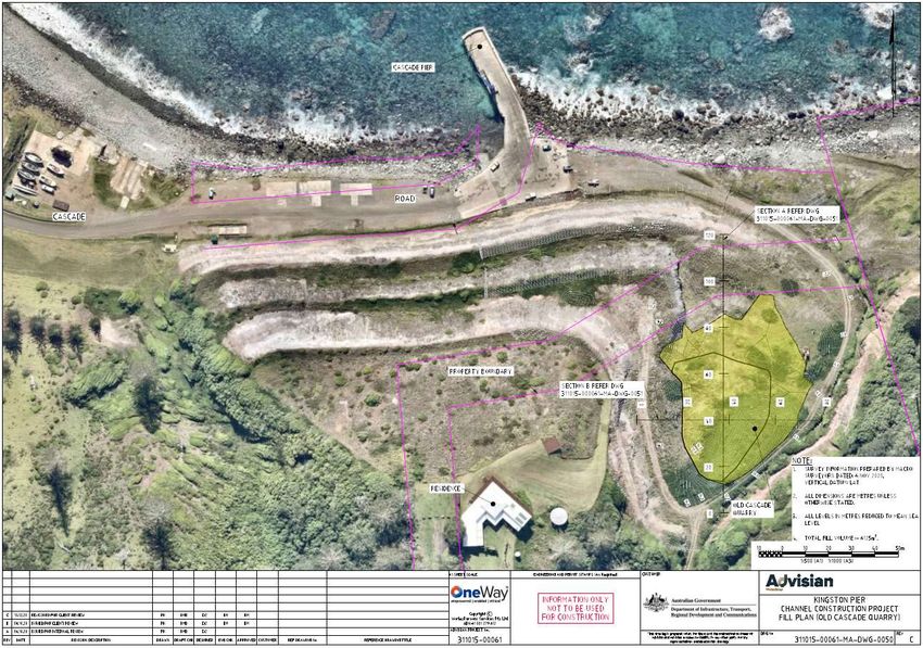
Figure 9 – Aerial view of the proposed extraction area, temporary stockpile and detonator storage.
2.6. Feasible Alternatives to the Proposed Quarry Development
Norfolk Island is approximately 8.0 kms x 5.0 kms and has an area of about 3,500 hectares.
Approximately two thirds of the Island is National Park or Public Reserves. Given the island’s limited
area and the proportion dedicated to conservation, options to develop a new quarry on Island are
very limited.
There is currently no reliable source of rock for processing to serve the local construction industry and
general public works on Island. NIRC has identified Headstone Cliff as a site for drilling to determine
the quality of rock as part of investigations for development of a quarry to supply the Island’s future
long term rock needs. Other sites are also under consideration for development of a long-term rock
supply with concurrent development of port facilities, including Jacobs Rock on the west coast of the
Island and Cascade Cliff adjacent to the Cascade Jetty to the north of the Youngs Road proposed
extraction area. Each of these three proposals present complexities and logistics challenges, including
that suitable drilling equipment to determine rock quality would need to be hired and shipped to the
Island. The investigations and planning will take time to resolve. In the meantime, an immediate short-
term supply of rock is essential for local industry and public works.
The option of importing rock to meet current demand has been considered. Rock was recently
imported to the Island to enable a major re-seal of the Airport Runway which was undertaken by Boral
Resources. There is no wharf for ships to berth to unload cargo at Norfolk Island and goods are
freighted from ship to shore in lighter boats and lifted by crane from the lighter boats on to the jetty.
This method of cargo handling restricts the efficiency of delivery of heavier goods and materials, such
as bulk supplies of rock, to the Island. Unloading bulk materials and heavy equipment for major capital
21EIS – Proposed Youngs Road Quarry Cascade, September 2021
works projects requires construction of a temporary ramp at the shore to enable barges to berth and
connect to the temporary ramp and enable equipment and materials to be unloaded by roll-on/roll-
off method. A temporary ramp was constructed for the Airport Runway reseal project and bulk
supplies of rock were imported in bags loaded directly from the barge to carting trucks and delivered
to site.
At present, bulk supplies of rock would need to be imported using this approach. Based on the Boral
project, the activity would be very expensive, and the final cost of the product would add significantly
to the cost of construction on Island. Until there are alternative permanent shipping facilities on Island
such as a wharf, importing bulk supplies of rock is not considered a feasible alternative for the regular
ongoing supply of rock for the Island.
The proposed extraction of rock from the Youngs Road proposed extraction area aims to supply the
Island’s immediate on-going demand for rock for construction and general public works and
maintenance. The proposed extraction area would yield a relatively small amount of rock; however,
the proposal presents an interim solution to supply rock for general construction and maintenance
while long-term solutions for the supply of rock are investigated.
22EIS – Proposed Youngs Road Quarry Cascade, September 2021
3. Strategic and Statutory Context
3.1. Planning Act 2002 NI
Under section 45(4) of the Planning Act 2002 (NI) all development applications for ‘significant
development’ as defined in the Act; and prescribed development as identified in Schedule 1 of the
Regulations, must be accompanied by an EIS prepared in accordance with the Act including
requirements prescribed by Schedule 2 of the Regulations – ‘Matters to be included in Environmental
Statement’ (Appendix A) and any directions issued under section 45(6) of the Act. Section 45(6)
requires consultation with the Chief Executive Officer (General Manager) for directions to guide the
environmental assessment and statement. As noted in section 1.4, pursuant to section 45(6) of the
Act, NIRC as the Applicant consulted with Port Macquarie Hastings Council (PMHC) as delegate of the
General Manager for directions for the assessment and statement. PMHC issued specific directions,
referred to as the Chief Executive Officer Directions for Environmental Impact Statement, which are
at Appendix B. Clause 28 of the Regulations requires that an EIS includes the matters set out in
Schedule 2 of the Regulations and other matters specified in directions given under section 45(6) of
the Act. It is the intent that this EIS addresses the relevant matters required to comply with Cl. 28 of
the Regulations.
3.1.1. ‘Significant Development’ status of DA
The proposed quarry development is defined as ‘extractive industry’ in the Norfolk Island Plan 2002
(‘the Plan’) and requires development consent. The proposed quarry development was declared
‘significant development’ by the Minister under section 28C(5)(a) of the Act in March 2019. The
proposal was eligible for consideration to be declared significant development as it is of a type of
infrastructure prescribed in Clause 15A of the Planning Regulations 2004 (NI) (‘the Regulations’),
specifically ‘(f) extractive industries’.
The proposed quarry development was declared ‘significant development’ as the proposal meets the
criteria specified in section 28D(1) of the Act; i.e.:
(a) the development is to establish or upgrade infrastructure of a type prescribed by the
regulations;
In addition, the proposal complies with the matters identified in section 28D(2)(a)-(e) of the Act to be
considered ‘significant development’ including that the proposal:
has the potential to deliver various economic benefits to the broad community; and significantly
to provide a supply of rock on Island to process into rock products locally and maintain reasonable
costs for product to support local industry;
would allow time to thoroughly investigate long term options for sourcing rock to supply
construction on Island; including potential sites on Island for a quarry and assessment of potential
biosecurity risks associated with importing rock products;
is consistent with the Norfolk Island Plan 2002; as the development site for the proposed quarry
is within the Cascade Activity Node Preferred Dominant Land Use Area and the proposal complies
with the objectives for that Preferred Dominant Land Use Area;
23EIS – Proposed Youngs Road Quarry Cascade, September 2021
is consistent with Council’s Strategic Planning framework, specifically to plan for the supply of rock
and materials to support infrastructure and construction; and commence the development of a
plan for the on-going supply of rock; and
is consistent with the general objectives of the Norfolk Island Environment Strategy 2018-2023
(Norfolk Island Regional Council, 2018) regarding planning for additional resources and specifically
rock resources; as the proposal may provide an interim supply of rock while potential rock
extraction sites and sources are scoped and potential impacts of various options assessed
holistically and strategically.
‘Extractive industry’ is a prescribed use or development in the Regulations. Section 45(4) of the Act
requires development applications for declared significant development and prescribed use or
development to be accompanied by an environmental impact statement (EIS).
The Significant Development Declaration (Appendix H) is subject to the following conditions:
1. A heritage impact statement considering the proposed Youngs Road and Cascade Reserve site and
surrounding area must be undertaken by an independent expert and included with the
development application. The statement must consider the potential heritage values of the site,
with reference to the endorsed nomination of the Australian Heritage Council for Cascade Reserve
to be included on the Commonwealth Heritage List.
2. Negotiations must commence between the Council and the Commonwealth for a licence
agreement for use of the relevant sections of Cascade Reserve, including the terms and conditions
for the extraction of rock from the site.
The proposed development includes land that is within Cascade Reserve. Cascade Reserve is identified
as a heritage item in the Norfolk Island Heritage Register prepared under the Heritage Act 2002 (NI).
Section 28 of the Heritage Act 2002 (NI) requires that a heritage impact statement (HIS) accompany a
DA that is in relation to, or likely to affect a heritage item.
Therefore, the DA for the proposed quarry at Youngs Road is accompanied by:
This EIS that addresses the matters listed in Schedule 2 of the Regulations (‘Matters to be
included in environmental impact statement’) and the Chief Executive Officer Directions for
Environmental Impact Statement issued under section 45(6) of the Act (Appendices A & B
respectively); and
a Heritage Impact Statement (HIS) prepared by an independent expert (Evans 2020) that
meets the requirements of the conditions set on the significant development declaration
(Appendix C).
3.1.2. Ancillary Activities
The ancillary activities form part of the designated Significant Development, as they are necessary for
the quarry development to be carried out, specifically temporary storage of explosives and storage of
quarried rock. The Planning Act 2002 (NI) defines an “ancillary project” for a declared significant
development as a development that is integral and subservient to the declared significant
development.
An ancillary project that forms part of a declared Significant Development does not require separate
“declaration”. However, an ancillary project for a declared significant development requires
development approval. Accordingly the subject DA seeks approval for the declared significant
development of the Youngs Road quarry and the ancillary projects; being storage or blasted rock at
land adjacent to Runway 11 at Portion 183 and storage of bulk explosives at part Portion 109a(rem)
24EIS – Proposed Youngs Road Quarry Cascade, September 2021
under Part 5, Division 2, Subdivision 2A – Declared significant developments and ancillary projects in
the Act.
Portion 109a(rem) is known as ‘Anson Point Nesting Ground’ which is also identified as a heritage item
in the Norfolk Island Heritage Register prepared under the Heritage Act 2002 (NI). Under section 28
of the Heritage Act 2002 (NI), a heritage impact statement (HIS) would also be required to accompany
a DA for that land. However, section 34(3)(a) of the Planning Act 2002 (NI) provides that the Chief
Executive Officer may waive the requirement for information or documents required by the Plan or
any other enactment to accompany a development application. The use of land at Anson Point for
storage of explosives would be temporary and would not involve any construction or site works that
would cause permanent change. It is considered that the temporary use of land at Anson Point would
not affect nor have an impact on the heritage values of the site. Given the minor and temporary
character of the activity at Portion 109a(rem), the requirement to prepare a heritage impact
statement under section 28 of the Heritage Act 2002 (NI)in relation to storage of explosives was
waived by the NIRC CEO on 23 June 2021. The storage of bulk explosive material does not represent
a risk of explosion, which further supports the waiving of this requirement. The signed request for
waiver has been included in Appendix K.
3.2. Norfolk Island Plan - Strategic Plan and Zoning Scheme
In the Norfolk Island Plan 2002 (‘the NI Plan’) the proposed activity is defined as Industry- Extractive:
“INDUSTRY – EXTRACTIVE means any industry involving the extraction of sand, clay gravel,
turf, soil, rock, stone or similar materials from Land including, when carried out on the Land
from which any substances are extracted or on Land adjacent thereto, the treatment of such
materials and the manufacture of products from such materials.
3.2.1. Part A – Strategic Plan
In Part A - Strategic Plan, the Cascade Jetty and Cascade Cliff area, including the subject land, is
identified as ‘Activity Node Preferred Dominant Land Use Area’ (see Figure 10). ‘Activity Nodes’ are
intended to provide the necessary and essential industrial and infrastructure functions on Norfolk
Island in the long term. The use and development types to be encouraged in the Activity Node
Preferred Dominant Land Use area are limited to air and sea transport, infrastructure and industrial
uses. The proposed development of a quarry at the subject land complies with the objectives for the
Activity Node Preferred Dominant Land Use.
25You can also read