ECOLOGY AND BIODIVERSITY ASSESSMENT OF THE SKA PHASE 1 IN SOUTH AFRICA - (SKA) South Africa
←
→
Page content transcription
If your browser does not render page correctly, please read the page content below
ECOLOGY AND BIODIVERSITY
ASSESSMENT OF THE SKA PHASE 1
       IN SOUTH AFRICA
                                           Prepared by:

  Dr Sue Milton, SACNASP Professional Natural Scientist (Reg. No. 400047/08), RENU-KAROO Veld
                                        Restoration cc.

                                     Reviewed and edited by:

 Dr Joh R Henschel, Manager of the South African Environmental Observation Network (SAEON) Arid
                                           Lands Node”; and
Lydia Cape, Project manager of the SKA Phase 1 Strategic Environmental Assessment at the Council for
                                  scientific and Industrial Research
Summary
This Biodiversity and Ecology Specialist Report is largely based on desktop studies and field research
conducted for other projects within the KCAAA1 area, supplemented by a short data collection visit to
the core area and sites of eight proposed radio telescope receivers to verify desktop assessments. The
vegetation, flora and smaller fauna of the project area are poorly documented. All available records
obtained from SABIF and other sources were at a quarter degree or degree scale so that plant and
animals species records could not be assigned to particular land parcels, but only to a 50 km radius of
the proposed SKA infrastructure in most cases.

In the absence of accurate species distribution data, the specialist assumed that plant and animal
species richness is correlated with habitat heterogeneity and therefore used habitat heterogeneity as
the major surrogate used to generate sensitivity scores for quantifying likely response of the SKA
Phase 1 environment and biota to physical disturbance. The sensitivity map of the SKA Phase 1 area,
including the core area is shown in the map below. Sensitivity was scored on the basis the number of
habitat types in each land parcel (in the spiral arms) or 25 square kilometre block (core area) based on
the number of habitat types recorded in the block in fine scale maps prepared by Simon Todd (2016)
for SAEON. This score increased by 1 if rare species, water features or steep topographic gradient were
present. Scored values were then classified as follows 1-2 =low sensitivity, 3-4 medium sensitivity, 5-6
high sensitivity.

Summary-Map: Sensitivity map for the SKA Phase 1 study area based on habitat heterogeneity,
rarity, steepness and water features
Because of the uncertainty around the distribution of species of conservation concern and the coarse
nature of the sensitivity mapping, the final selection of sites for telescopes, cable trenching and roads
must be inspected by a field ecologist before construction, and where found to impact sensitive
habitats, an acceptable alternative should be approved.
For the purpose of this assessment for SKA Phase 1, the specialist considered that the sites that are
impossible to restore once they have been destroyed and the habitats that are essential for the survival
of rare plant or animal species should be no-go areas. These include:
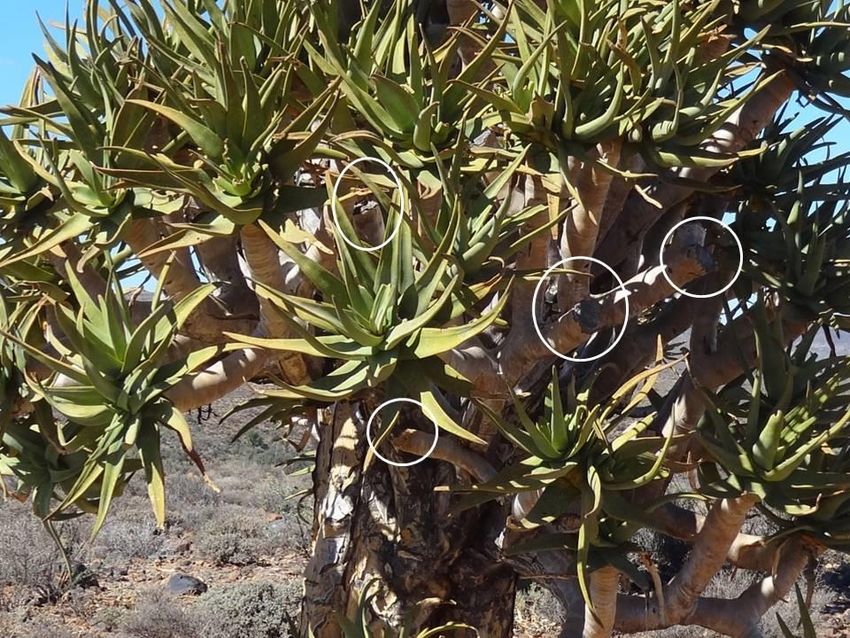
Aloe dichotoma populations (a slow-growing, range-restricted plant species),
exposed mudstone rock sheets that are home to rare succulents and reptiles,
koppies and steep slopes that cannot be restored once destroyed by blasting, trenching or
road building,
pans and wetlands where development may change drainage patterns and affect the wildlife
(especially birds, amphibians and fish) that use the pans after rain, and
red sanddunes which are habitat of the narrow range endemic and substrate-restricted Red
Lark.
Negative impacts associated with the SKA Phase 1 development are related to construction and
operation of the road network, trenching for installation of optic fibre and electrical cables, installation
of telescope installations, associated construction camps and borrow pits, overhead electrical
infrastructure, and people on site during the construction and operational phases. Unmitigated
construction phase impacts will include removal of vegetation, damage to sensitive habitats,
displacement of fauna and destruction of rare plants, increased risk of soil erosion through road
construction on inclines or poor management of runoff from telescopes, roads or other hardened
surfaces, alteration of drainage patterns and acceleration of the spread of invasive alien plant species.
Unmitigated operational phase impacts include ongoing bird mortality caused by strikes or
electrocution on overhead electrical or cable infrastructure, failure to restore areas damaged during
construction, failure to control invasive alien plant species, failure to maintain drainage works and
control accelerated erosion, roadkill, and reinforced or electrical fencing that might genetically isolate
or reduce populations of some reptiles (tortoises, snakes, monitor lizards) and mammals (Aardvark,
Pangolin).
Positive impacts associated with the SKA Phase 1 development include:
Exclusion of the area from prospecting and mining;
Release of the Core area from its current grazing regimes (livestock ranching),
Initiation of programmes to control invasive alien plant species, particularly Prosopis that has
invaded drainage lines and pans, and is posing a threat to water resources and biodiversity,
Stimulating research on ecology, biodiversity and ecological restoration in the Central Karoo,
and
Declaration of the Core area as a protected area has potential for ecosystem conservation, and
presents opportunities for long-term monitoring of predator and other wildlife populations,
vegetation dynamics, and ground and surface water responses to cessation of livestock
farming.
The specialists identified the following key mitigation measures and management actions:
During pre-construction:
Complete avoidance of No-Go areas;
Preconstruction verification of site sensitivity for roads, telescopes and trenches and
allocation of activities to approved less sensitive sites; and
Minimisation of the size of the damage footprint.
During construction:
Management of machinery and people on site to minimise damaging activities such as
spills, roadkill, hunting and littering,
Management of invasive alien plants during preparation for construction, as well as during
the operational phase on all sites disturbed by construction;
Protection and/or translocation or red Listed and protected plant species prior to and
during the construction phase as recommended in the plant rescue and protection plan;
and
Post construction compliance with the revegetation and habitat restoration plan.
During operation:
Development of detailed management plans for ongoing control of established
populations of invasive alien plants in the SKA Core and land parcels;
Monitoring and ongoing restoration and runoff management from of damaged and
disturbed sites;
Monitoring of animal populations likely to be affected by cessation of predator control
and water supplementation;
Monitoring of bird, mammal and reptile mortality associated with boundary fences, roads
and overhead infrastructure;
Development of a policy for response to locust outbreaks within the SKA Core; and
Monitoring and management of human activities on site including off-road driving, waste
disposal and removal or plants or animals.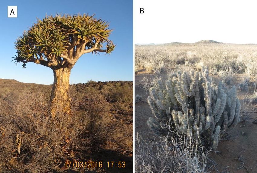
Table of contents

I.        INTRODUCTION                                                                 1

II.       STUDY METHODOLOGY                                                            15
1)       Baseline description of the study area                                        15
2)       Habitat sensitivity map for the study area                                    16
3)       Field survey                                                                  17
4)       Data sources                                                                  19

III.      SENSITIVITY ASSESSMENT                                                       20
1)       Key sensitive ecology and biodiversity features                               20
2)       Key heterogeneous areas                                                       22
3)       Conservation priority areas of the KCAAA1                                     22
4)       Detailed description of sensitivities                                         23

IV.       POTENTIAL IMPACTS OF SKA1_MID ON ECOLOGY AND BIODIVERSITY
          WITHIN THE SKA1_MID SEA STUDY AREA                        28
1)       Impacts related to the SKA core area land acquisition                         28
2)       Impacts related to the extraction of material with borrow pits and quarries   29
3)       Impacts related to the construction and upgrading of access roads             30
4)       Impacts related to the construction of SKA dish-antennas                      33
5)       Impacts related to trenching                                                  34
6)       Impacts related to the Overhead electricity / optic cable operation           34
7)       Impacts related to the clearance of vegetation                                38
8)       Impacts related to people working in natural environment                      41

V.        MITIGATION MEASURES AND ENVIRONMENTAL MANAGEMENT
          ACTIONS                                                                      43
1)       Plants rescue and translocation                                               43
2)       Revegetation and Habitat Restoration                                          43

VI.       SUMMARY IMPACT TABLES                                                        47
1)       Construction phase                                                            47
2)       Operation phase                                                               52

VII.      CONCLUSIONS AND RECOMMENDATIONS                                              64

VIII.     APPENDICES                                                                   65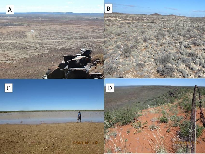
I. Introduction
The study area of the Strategic Environmental Assessment (SEA) for the first phase of the SKA project
(SKA1_MID) is located within the Karoo Central Astronomy Advantage Area 1 (KCAAA1). The study area
is characterised by an arid climate and receives in average less than 200 mm annual rainfall with a
mean annual rainfall at Fraserburg is 182 mm, Brandvlei 127 mm, and Carnavon 209 mm. The study
area lies mainly within the Karoo Basin where geology is dominated by mudstone and sandstone rocks
derived from marine sediments (Figure 2). These relatively soft sediments weather to form stony plains
and flat or rounded hills. Dolerite has intruded through the sedimentary strata as dykes and pipes that
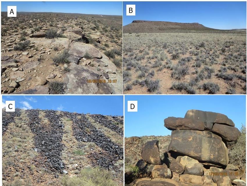
weather to form hills and ridges characterised by round brown or black boulders (Figure 1 C & D).
Where dolerite intrusions overlie softer sediments, the hard capping results in formation of flat-topped
ridges and mesas (Figure 1 B). The landscape thus comprises abrupt ridges and conical hills scattered
across extensive sandy and silty plains. Within the study area, the altitude ranges from 1500 m a.s.l. on
the escarpment in the South (Fraserburg) to 900 m a.s.l. on the pans between Brandvlei and Van
Wyksvlei. There is thus a gentle gradient of 0.6 km over a distance of 300 km. Drainage is mostly
endorrheic Rivers arising on the escarpment (e.g. Sakrivier) and off ridges and hills, flowing northwards
and discharging into the pans (Brandvlei, Verneukpan, VanWyksvlei) where the water evaporates.
Figure 1. Typical rock formations of the KCAAA1 area. (A) Sedimentary rock of the Beaufort Series 10 km north of
Fraserburg, (B) Ecca mudstone ridge capped by Dolerite 30 km south of Williston, (C) Dolerite scree forming stripes on a
ridge in the SKA SKA core area, (D) stacked Dolerite boulders near Van Wyksvlei
1|Page
Figure 2. Geology of KCAAA1 area showing the sedimentary rocks in greens and the igneous rocks in pinks and browns

                                                                                                                     2|Page
Although the soils of the plains are generally shallow to skeletal, wind and water-borne sediments
have accumulated in parts of the landscape (Figure 3). In the Van Wyksvlei area, many stony plains are
devoid of soil (habitat for Sclater’s Lark) whereas wind-blown sand has elsewhere accumulated to form
dunes that overlie the mudstone plains and dolerite outcrops in some places. These orange sand
dunes are habitat for the endemic Red Lark. Silt and clay has accumulated in shallow valleys to form
extensive level pans (vloëre) between Brandvlei and Van Wyksvlei. Deep silty friable alluvium flanks the
Sakrivier and its tributaries creating a suitable habitat for the Critically Endangered Riverine Rabbit.

Figure 3. Substrates in KCAAA1. (A) Sandy and silty plains in SKA Core area, (B) calcrete plains south of Williston, (C)
clay and silt accumulated in pans in the Brandvlei-Van Wyksvlei area, red sand dunes north of Van Wyksvlei

According to Mucina & Rutherford (2006), the KCAAA1 contains 23 vegetation types (Figure 4) among
which ten vegetation types form part of the Nama-Karoo Biome. Of these the four Upper Karoo types
(NKu 1-4) make up the majority of the area together with Bushmanland Arid Grassland (NKb3). The
pans classified as azonal vegetation known as Bushmanland Vloëre (AZi5) follow drainage features
through the Upper Karoo vegetation types. Relatively small portions of eight Succulent Karoo Biome
vegetation types are included along the western boundary of the KCAAA1 area (not located within the
SKA1_MID SEA study area). A small area of Renosterveld occurs in the southern edge of the KCAAA1
on the escarpment. It is significant that the majority of the listed (rare, vulnerable, endangered) flora of
the area was limited to half degree squares classified as Hantam Succulent Karoo or Roggeveld
Succulent Karoo that lie beyond the boundaries of the SKA1_MID SEA study area (Figure 4).

                                                                                                              3|Page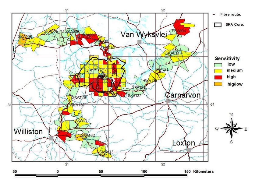
Figure 4. Vegetation map for the KCAAA1 area from Mucina & Rutherford (2006). The major types indicated in the abbreviated key to the right of the map are: AZ = azonal vegetation of
drainage lines and pans, DG = Desert Grassland, FR = Fynbos of the Renosterveld type, NKb = Nama Karoo bushmanland types, NKu = Nama Karoo high altitude types, SK = Succulent
Karoo

                                                                                                                                                                       4|Page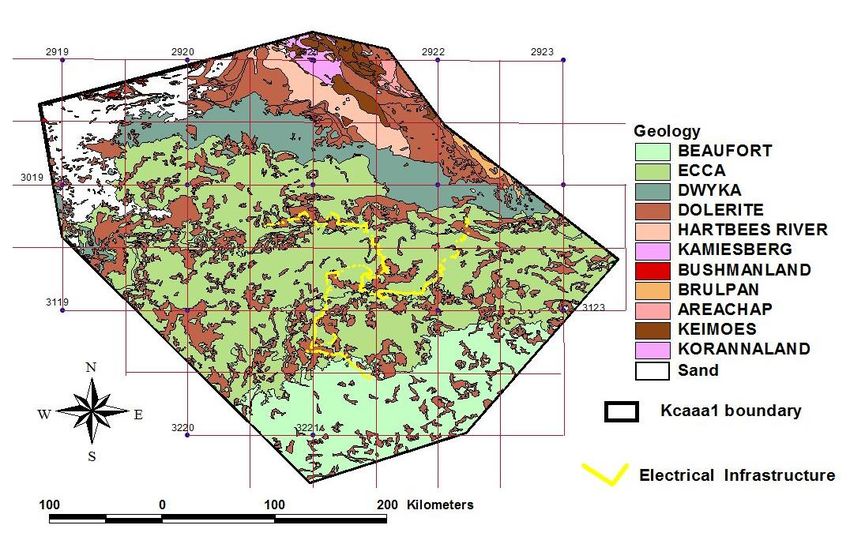
The Succulent Karoo vegetation types are made up of low-growing (
Descriptions of plant communities in the unpublished botanical and faunal report prepared for
MeerKat in 2008 are integrated and summarised below:
Dolerite hills, inselbergs and pediments of exposed dolerite sills and dykes have sparse
vegetation cover. Vegetation include a number of protected plant species (Aloe dichotoma,
Boscia albitrunca) as well as Rhigozum obovatum
Silt plains characterised by Salsola aphylla with Lycium cinereum, L. oxycarpum and an
understorey of succulents, forbs and a few grasses (Drosanthemum sp., Malephora crocea,
Ornithogalum sp., Setaria verticillata, Stipagrostis ciliata, S. obtusa. Mesembryanthemum
guerichianum). Invasive alien species present were Prosopis glandulosa var. torreyana
(mesquite), and Atriplex lindleyi subsp. inflata (spongefruit saltbush);
Gravel plains below the flat-tipped hills were dominated by Rhigozum trichotomum with
Lycium species, Salsola aphylla, and a grassy understorey of Stipagrostis obtusa with Aridaria
noctiflora, Asparagus retrofractus, Drosanthemum sp., Lebeckia, Leysera sp., Lycium cinereum,
Malephora crocea, Osteospermum scariosum, Pentzia incana, Pteronia sp., Ruschia spinescens,
Salsola tuberculata, Zygophyllum microphyllum and invasive alien Atriplex lindleyi;
Calcrete plains with lower, sparser vegetation similar in composition to gravel plains but with a
greater abundance of Salsola tuberculata;
Sand Washes or larger drainage lines are dominated by Stipagrostis namaquensis with Lebeckia
spinescens, Cenchrus ciliaris and scattered Searsia (Rhus) lancea trees;
Disturbed areas associated with farm dams and boreholes are characterised by large tree
species (mainly invasive alien Prosopis glandulosa) and herbaceous indigenous and alien
plants.
Gibbs Russel (1987) estimated that 2,147 species occurred in a central area of the Nama Karoo
2 10
(198,000 km ), of which 377 (16 %) are endemic . Within the KCAAA1 area, 35 (1.8%) of the 1952 plant
species on record are endemic to the vegetation types shown in Figure 4 and within the parts of those
vegetation types included within the KCAAA1 boundary. Of the 35 endemics 23 species are in the
Renosterveld and Succulent Karoo types on the western boundary of the study area.
Amongst the 1899 species of higher plants and 51 species of mosses and lichens known to occur in
the KCAAA1, the higher plants belong to 101 families (Table 1), the most speciose of which are
Asteraceae (326 species), Mesembryanthemaceeae (156), Poaceae (147), Fabaceae (99) and Iridaceae
(73). The mosses and lichens belong to 21 families, the most speciose being Parmeliaceae (11),
Ricciaceae (10) and Pottiaceae (7). Data indicate that species densities are greater in the western edge
of the study area (Succulent Karoo vegetation types) than in the Nama Karoo vegetation types that
cover the rest of the area. Within the Nama Karoo, species richness (mapped per 50 x 50 km block)
appears greater at higher altitudes and where there are closely-spaced contours (broken terrain), than
in the northern central region around the pans, where topography is flat (Figure 5). Additional factors
that may affect species numbers reported per unit area is the accessibility of an area and its proximity
to towns. Within the SKA1_MID SEA study area, there are records of only 1257 higher plant species in
93 families. These low numbers probably reflect under-collecting and are likely to increase during the
SANBI and SAEON studies.
6
McDonald, D. 2011. Botanical Assessment for a proposed wind energy facility at Copperton, Northern Cape. Prepared for
Aurecon SA (Pty) Ltd.
7
Lloyd, J. W. 1989. Phytosociology of the Vaalputs radioactive waste disposal site, Bushmanland, South Africa. South
African Journal of Botany, 55, 372-382.
8
vd Merwe, H., van Rooyen, M.W. & van Rooyen, N. 2008. Vegetation of the Hantam-Tanqua-Roggeveld subregion, South
Africa. Part 2: Succulent Karoo Biome related vegetation. Koedoe 50: 160-183
9
Rubin, F. and Palmer, A.R. 1996. The physical environment and major plant communities of the Karoo National Park, South
Africa. Koedoe 39:25-52
10
Gibbs Russel, G.E. 1987. Preliminary floristic analysis of the major biomes in southern Africa. Bothalia 17: 213-227.
6|PageFigure 5. Plant species densities per half degree square (ca. 50 x 50 km) plotted against relief and drainage features
7|PageIn the KCAAA1 area there are 135 records of 91 plant species of conservation concern (listed as
declining, vulnerable, threatened, endangered or critically endangered in the Threatened Species
11
Programme ). Most records are from species-rich half degree squares in Succulent Karoo vegetation
and in areas with broken topography (Figure 5). The plant families with the most species of
conservation concern (Table 1) are Mesembryanthemaceae (18), Iridaceae (13), Amaryllidaceae (9) and
Asphodelaceae (8). Within the SKA1_MID SEA study area there are only 89 records of 47 plant species
of conservation concern (Table 1). The plant families with the most species of conservation concern are
Iridaceae (12), Amaryllidaceae (6) and Apocyaceae (5), all of which are geophytes or small shade
succulents that are difficult to detect in field surveys during dry periods. Three plant species of
conservation concern occur within the SKA core area, namely Acacia erioloba (declining), Aloe
dichotoma (VU) and Hoodia gordonii (Data deficient, declining) (Figure 6).
Figure 6. Listed plant species that occur in the SKA Core area. (A) Aloe dichotoma, (B) Hoodia gordonii,
(C), Acacia erioloba
12
In addition to Red Listed threatened species, the Northern Cape Nature Conservation Act , makes
provision for Specially Protected and Protected species of fauna and flora. There are 44 (25)“Specially
Protected” and 589 (337) “Protected” plant species in the KCAAA1 area, (and SKA1_MID SEA study
area) respectively . In terms of Section 49 of the Act, no person may, without a permit (a) pick; (b)
import; (c) export; (d) transport; (e) possess; (f) cultivate; or (g) trade in, a specimen of a “specially
protected plant”. All these restrictions (with the exception of possession) also apply to “protected
plants”. The Specially Protected and Protected plant species present in the SKA1_MID SEA study area
include slow-growing trees (Boscia spp, Acacia erioloba), geophytes in the Amarayllidaceae,
Hyacinthaceae, Iridaceae, Oxalidaceae, most succulent plants in the Apocynaceae, Asphodelaceae,
Crassulaceae, Euphorbiaceae, Geraniaceae, Portulacaceae, and certain medicinal plant species
(Harpagophytum, Sutherlandia) (Figure 7).
11
Threatened Species Programme Red List of South African Plants Online provides up to date information on the national
conservation status of South Africa's indigenous plants on the SANBI website http://redlist.sanbi.org/
12
Northern Cape Nature Conservation Act 9/2009 (Provincial Gazette 1566 dated 19 December 2011)
8|PageFigure 7: Medicinal plants (A) Boophane distichya, (B) Lessertia (Sutherlandia) frutescens, (C) Arctopus echinatus, (D)
Harpagophyton spp, and slow-growing trees (E) Ozoroa dispar (photo Senckenberg Research Institute) and (F) Boscia
albitrunca protected under Northern Cape Nature Conservation Act
Table 1: Species richness and Red Listed species in plant families of the KCAAA1 and SKA1_MID SEA study area- the
species occurring within the SKA1_MID SEA study area are indicated in brackets (i.e.”()”)
Liste Liste Liste
spp/fa spp/fa spp/fa
Family d Family d Family d
m m m
spp spp spp
ACANTHACEAE 20 (7) 1 (0) LAMIACEAE 13 (13) RUBIACEAE 11 (8)
AIZOACEAE 38 (25) LOASACEAE 1 (1) RUTACEAE 5 (3)
AMARANTHAC
13 (8) LOBELIACEAE 4 (4) SALICACEAE 2 (0)
EAE
AMARYLLIDACE SALVADORACEA
29 (14) 9 (6) LOPHIOCARPACEAE 1 (1) 1 (0)
AE E
ANACARDIACE
7 (4) LORANTHACEAE 5 (5) SANTALACEAE 9 (7) 2 (2)
AE
APIACEAE 10 (6) 1 (0) MALVACEAE 49 (42) SAPINDACEAE 1 (0)
SCROPHULARIA 106
APOCYNACEAE 56 (40) 5 (5) MARSILEACEAE 3 (3) 6 (4)
CEAE (68)
SINOPTERIDACE
ARALIACEAE 1 (0) MELIACEAE 1 (1) 7 (6)
AE
ASPARAGACEA 20
18 (15) MELIANTHACEAE 1 (1) SOLANACEAE
E (16)
ASPHODELACE
42 (24) 8 (3) MENISPERMACEAE 3 (2) TAMARICACEAE 3 (3)
AE
MESEMBRYANTHEM 156 18 TECOPHILAEACE
ASPLENIACEAE 1 (1) 1 (1)
ACEAE (75) (3) AE
326 THYMELAEACEA
ASTERACEAE 5 (3) MOLLUGINACEAE 27 (19) 6 (6)
(234) E
BIGNONIACEAE 3 (3) MONTINIACEAE 1 (1) URTICACEAE 2 (1)
BORAGINACEA
19 (15) MORACEAE 2 (0) VAHLIACEAE 1 (1)
E
BRASSICACEAE 39 (29) MYRTACEAE 1 (1) VERBENACEAE 3 (3)
BUDDLEJACEAE 4 (2) NEURADACEAE 3 (3) VISCACEAE 1 (0)
9|PageListe Liste Liste
spp/fa spp/fa spp/fa
Family d Family d Family d
m m m
spp spp spp
ZYGOPHYLLACE 20
BURSERACEAE 2 (0) NYCTAGINACEAE 3 (2)
AE (20)
CACTACEAE 3 (3) OLEACEAE 1 (1)
CAMPANULACE
10 (5) 1 (0) ONAGRACEAE 2 (2)
AE
CAPPARACEAE 11 (5) OPHIOGLOSSACEAE 2 (2) 1 (1) BRYOPHYTES
mosse
CARYOPHYLLA s
15 99) ORCHIDACEAE 4 (2) Family
CEAE /liche
ns
CELASTRACEAE 6 (3) OROBANCHACEAE 2 (1) AYTONIACEAE 1
CHENOPODIAC
46 (37) OXALIDACEAE 30 (15) 3 (2) BACIDIACEAE 1
EAE
BARTRAMIACEA
COLCHICACEAE 13 (8) PAPAVERACEAE 2 (1) 1
E
CONVOLVULAC
3 (3) PASSIFLORACEAE 1 (0) BRYACEAE 1
EAE
CRASSULACEAE 53 (26) 5 (2) PEDALIACEAE 5 (4) BRYACEAE 1
CUCURBITACEA
12 (5) PEGANACEAE 1 (0) FABRONIACEAE 1
E
CYPERACEAE 21 (13) PHYLLANTHACEAE 3 (3) FISSIDENTACEAE 1
EBENACEAE 11 (4) PLANTAGINACEAE 4 (1) FUNARIACEAE 2
GIGASPERMACE
ELATINACEAE 1 (0) PLUMBAGINACEAE 3 (3) 1
AE
147
ERICACEAE 2 (0) POACEAE 1 (0) GRIMMIACEAE 2
(108)
ERIOSPERMACE
7 (2) POLYGALACEAE 13 (12) HYMENELIACEAE 1
AE
EUPHORBIACEA
33 (33) POLYGONACEAE 4 (4) LECANORACEAE 2
E
FABACEAE 99 (62) 6 (3) PORTULACACEAE 24 (1) 1 (0) LECIDEACEAE 1
FRANKENIACEA POTAMOGETONACE
1 (1) 1 (0) PARMELIACEAE 11
E AE
PERTUSARIACEA
FUMARIACEAE 3 (2) PROTEACEAE 5 (5) 2
E
PERTUSARIACEA
GENTIANACEAE 3 (2) PTERIDACEAE 6 (6) 1
E
GERANIACEAE 34 (16) RANUNCULACEAE 3 (1) PHYSCIACEAE 1
GISEKIACEAE 2 (1) RESEDACEAE 1 (1) POTTIACEAE 7
HYACINTHACE
43 (27) 2 (1) RESTIONACEAE 1 (1) PSORACEAE 2
AE
HYPOXIDACEAE 5 (3) RHAMNACEAE 3 (3) RICCIACEAE 10
13 TELOSCHISTACE
IRIDACEAE 73 (58) ROSACEAE 2 (1) 2
(12) AE
10 | P a g eListe Liste Liste
spp/fa spp/fa spp/fa
Family d Family d Family d
m m m
spp spp spp
JUNCACEAE 3 (3)
13
The KCAAA1 area overlaps the distributions of 90 mammals species according to 2016 IUCN records .
The list includes only two invasive alien mammal species, the House Mouse and the Black Rat. With the
exception of the Black Rhinoceros (that no longer freely occurs in the areas) all species are listed in the
Appendices. There are no endemic mammals in the region except perhaps the uncertain record of
Chrysochloris visagiei (Visagie's Golden Mole). Six small mammal species are near-endemic. These are
Grant's rock mouse (Aethomys granti), Shortridge's tree Rat (Thallomys shortridgei), Karoo Rock
Elephant-shrew (Elephantulus pilicaudus), Brush-tailed Hairy-footed gerbil (Gerbillurus vallinus),
Brukkaros Pygmy Rock Mouse (Petromyscus monticularis) and the Riverine Rabbit (Bunolagus
monticularis) (Hilton-Taylor 2000)
Two species are rated as Vulnerable. The Blackfooted Cat (Felis nigripes) is population is declining in
14
response to habitat degradation of predator control by poisoning , whereas the Ground Pangolin
(Smutsia temminckii) population is declining as a result of the value of its scales in traditional medicine,
15
and through electrocution on the lowest strands of electric fences . These two Vulnerable species
may well benefit from the SKA development.
Nine Near Threatened mammal species that may occur within the KCAAA1 area include Leopard,
Brown Hyaena, Honey Badger, Littledale’s Whistling Rate, Lesueur’s Hairy Bat, Straw-coloured Fruit Bat
and three species of Horseshoe Bat. The carnivore populations are declining in response to predator
control (Leopard, Brown Hyaena, Honey Badger). The Whistling Rat is threatened by land
transformation and the bats by wind farms and, in the case of the migratory Fruit Bat, by bush meat
16
hunting elsewhere in Africa .
The three remaining listed species are Data Deficient and all occur on the KCAAA1 periphery outside of
the SKA1_MID SEA study area. These are the once collected Chrysochloris visagiei (Visagie's Golden
Mole) on the Nuweveld escarpment , and the recently recognised and poorly documented
17
Elephantulus pilicaudus (Karoo Rock Elephant-shrew ) that occurs in rocky outcrops east of Calvinia,
18
and Thallomys shortridgei (Shortridge's Tree Rat ) recorded from the northern arid savanna margins of
the KCAAA1.
13
The IUCN Red List of Threatened Species. Version 2015-4. . Downloaded on 10 April 2016
14
Sliwa, A. 2008. Felis nigripes. The IUCN Red List of Threatened Species 2008: e.T8542A12917449.
http://dx.doi.org/10.2305/IUCN.UK.2008.RLTS.T8542A12917449.en. Downloaded on 11 April 2016.
15
Pietersen, D., Waterman, C., Hywood, L., Rankin, P. & Soewu, D. 2014. Smutsia temminckii. The IUCN Red List of
Threatened Species 2014: e.T12765A45222717. http://dx.doi.org/10.2305/IUCN.UK.2014-
2.RLTS.T12765A45222717.en. Downloaded on 11 April 2016.
16
Mickleburgh, S., Hutson, A.M., Bergmans, W., Fahr, J. & Racey, P.A. 2008. Eidolon helvum. The IUCN Red List of
Threatened Species 2008: e.T7084A12824968. http://dx.doi.org/10.2305/IUCN.UK.2008.RLTS.T7084A12824968.en.
Downloaded on 11 April 2016.
17
Smit-Robinson, H. & Rathbun, G. 2015. Elephantulus pilicaudus. The IUCN Red List of Threatened Species 2015:
e.T165924A21291059. http://dx.doi.org/10.2305/IUCN.UK.2015-2.RLTS.T165924A21291059.en. Downloaded on 11
April 2016.
18
Boitani, L. & Taylor, P.J. 2008. Thallomys shortridgei. The IUCN Red List of Threatened Species 2008: e.T21693A9309334.
http://dx.doi.org/10.2305/IUCN.UK.2008.RLTS.T21693A9309334.en. Downloaded on 11 April 2016.
11 | P a g eFigure 8: Known distribution of the Riverine Rabbit (Bunolagus monticularis) in the KCAAA1 (red polygon) and of the Karoo Padloper Tortoise (Homopus boulengeri) plotted against
KCAAA1, 2 and 3 outlines, and National Protected Areas expansion priorities
12 | P a g e19
According to maps in Minter at al. (2004) only 16 species of amphibians, all with Least Concern
status, have been recorded from KCAAA1 (see Appendices). Of these the Giant Bullfrog has special
20
protection status (Schedule 1) in the Northern Cape (Act9 of 2009) , and all other species are
protected under Schedule 2. The most common species are the Karoo Toad (Vandijkophrynus
gariepensis) and the Common Caco (Cacosternum boettgeri) recorded from 11 of the 13 degree
squares in the KCAAA1 area. Six of the amphibian species are unlikely to occur within the three spiral
arms of the SKA1_MID or within the SKA core area because they have been recorded from only one
degree square towards the margins of the KCAAA1.
The study area is fairly rich in tortoises and lizards, but snake diversity is low in comparison with higher
21
rainfall areas. The most recent reptile atlas (Bates et al. 2014) shows that 54 species may occur in the
KCAAA1 (see Appendices). The most widespread of these Common Sand Lizard, Common Ground
Agama, Southern Rock Agama, Spotted Desert Lizard, Namaqua Sandlizard, Tent Tortoise, Southern
Karusa Lizard and Western Three-striped Skink. Cordylid lizards (3 species) and the Namaqua
Chamaeleon (Figure 9) are Specially Protected under Northern Cape Nature Conservation Act (9/2009).
The only reptile species of conservation concern is the Karoo Padloper (Homopus boulengeri) tortoise
that is Near Threatened according to the assessment by Bates et al. (2014). This species would
probably benefit from reduced grazing by domestic livestock and a reduction in the populations of
Pied Crows that appear to be increasing in response to increased traffic and associated roadkill (Dean
2223
et al. 2005) . The Karoo Padloper, as indicated in Figure 8 should be present in the SKA Core and in
the southern part of the KCAAA1 including the Williston spiral arm and the southern part of the Van
Wyksvlei/Carnavon spiral arm.
Figure 9: Namaqua Chamaeleon, a low density species Specially Protected, in the Northern Cape
19
Minter, L.R., Burger, M., Harrison, J.A., Braack, H.H., Bishop, P.J. & Klopfer, D. (eds) 2004. Atlas and red data book of the
frogs of South Africa, Lesotho and Swaziland. SI/MAB series 9. Smithsonian Institution, Washington DC.
20
Northern Cape Nature Conservation Act ,2009 (ACT No. 9 of 2009)
21
Bates, M.F., Branch, W.R., Bauer, A.M., Burger, M., Marais, J., Alexander, G.J., & de Villiers, M.S. 2014. Atlas and Red List
of the Reptiles of South Africa, Lesotho and Swaziland. Suricata 1. South African National Biodiversity Institute
22
119.Dean, W.R.J., Milton, S.J. and Anderson, M.D. 2005. Use of road kills and roadside vegetation by Pied and Cape Crows
in semi-arid South Africa. Ostrich 77: 102-104
23
Dean, W.R.J. & Milton, S.J. 2003. The importance of roads and road verges for raptors and crows in
Succulent and Nama Karoo, South Africa. Ostrich 74:181-186.
13 | P a g eArthropods communities differ among closed and open shrubland, grassland, and rock outcrops at
24
Vaalputs (-30.1, 18.5 on the western edge of the Study area (Benade et al. 2016 ). Although the
diversity in all communities sampled at this site was similar, differences in species composition among
habitats indicates that arthropod diversity is likely to be greater in heterogeneous (complex)
landscapes than in homogeneous landscapes within the SKA.
Scorpions that occur in the KCAAA1 belong to the Buthidae (Genera Parabuthus and Uroplectes),
Ischinuridae (Genus Hadogenes), and Scorpionidae (Genus Opistophthalmus) (Figure 10 A-D). The
genus Opistophthalmus is endemic to southern Africa, and contains 59 species, many of which have
very small distribution ranges confined to the Northern Cape. (Lemmer 2003). Atlasing has not been
intensive enough to assign any species to particular areas of the SKA1_MID study area.
Spider diversity is high in the Nama Karoo. 464 species from 50 families have been recorded of which
74 species are Nama Karoo endemics and an additional 77 species near endemics. The most diverse
spider family in the Nama Karoo is the Gnaphosidae or burrowing spiders, but other endemic ground
dwelling spider families including Ammoxenidae and trapdoor spiders in the Cyrtauchenidae,
Ctenizidae (trapdoor spiders, Figure 10 D), Ioiopidae and Nemesiidae occur in Nama Karoo
25 26
(Dippenaar-Schoeman 2002 , Foord et al. 2011 ).
Figure 10: Arachnid species of the study area. Scorpions (A) Hadogenes phyllodes27 (Rock Scorpion), (B) Parabuthus
schlechteri, (C) Opistophthalmus carinatus, (D) Uroplectes carinatus, (E) Trapdoor spider (Stazimopus) retreat
The Brown Locust is a Karoo species and the KCAAA1 contains the locust outbreak ‘cradle, in that
swarming events originate on the sandy plains in the northern part of KCAAA1, and spread from there
24
Benade, P.C., Dreyer, L.L. & Roets, F. 2016. The importance of maintaining a mosaic of different plant communities for
arthropod biodiversity conservation at the Vaalputs radioactive waste disposal site, Bushmanland, South Africa.
African Entomology 24: 1-15.
25
Dippenaar-Schoeman AS 2002. Baboon and trapdoor spiders of southern Africa - an identification Manual. PPRI
Handbook13. ARC, Pretoria
26
Foord, S.H. Anna S. Dippenaar-Schoeman, A.S & Haddad, C.R. 2011. South African Spider Diversity: African Perspectives
on the Conservation of a Mega-Diverse Group. In Grillo, O. & Venora, G. (eds) Changing Diversity in Changing
Environment. ISBN 978-953-307-796-3. http://www.intechopen.com/books/changing-diversity-in-changing-
environment/south-african-spider-diversity-african-perspectives-on-the-conservation-of-a-mega-diverse-group
27
Photos reproduced from Lemmer, J. 2003. Scorpions of southern Africa. Struik
14 | P a g e28
to other parts of the Karoo and elsewhere in southern Africa . If the SKA core area is declared a
National Park or specially protected area, the SKA Organisation could motivate to obtain permission
from DAFF to exclude chemical control of locust swarms. Should no exception be granted then, in the
case of a locust outbreak, SKA may need to allow spraying teams to enter and kill locust swarms
without an EIA as prescribed by the 1998 policy and actively practised. Spraying of locust hoppers kills
most other arthropods and consumption of poisoned locusts leads to mortality of some avian and
mammalian predators of locusts. To avoid disruption of SKA activities it is strongly advised that
application is made to DAFF to exempt the SKA from locust spraying and that the area is maintained
as a control to understand locust and locust predator dynamics in the absence of chemical control.
Alternative less disruptive locust control measures that could be applied in the SKA area are myco-
insecticides (pathogenic fungi), barriers and baits.
II. Study methodology
1) Baseline description of the study area
The baseline description of the study area of the strategic environmental assessment (SEA) for the first
phase of the SKA project (SKA1_MID) includes geographic information system (GIS)-based maps and
text descriptions of terrestrial ecology features of interest including biodiversity hotspots, and habitats
critical for persistence of threatened, rare and locally endemic plant and animal species. The maps
combine coverages for vegetation types (Mucina & Rutherford 200629), Critical Biodiversity Areas for
the Namaqua District (critical biodiversity areas coverages), geology, rainfall and landcover,
distribution data for mammal species of Conservation Concern obtained from the International Union
30
for Conservation of Nature (IUCN) website bird distribution and species richness data based on the
Bird Atlas31 and supplemented from our own sources, and information on amphibian32 and reptile
distributions33.
Baseline descriptions of the vegetation were based on checklists available from SANBI’s biodiversity
information website, SANBI red data list, surveys recently conducted by SAEON and SANBI, data
collected during impact assessments carried out by myself for private clients or as academic research.
The plant species checklist compiled for the KCAAA1 (and included in the Appendices) was derived
34
from data downloaded from the SANBI SABIF and Plants of southern Africa (POSA) websites,
combined with the consultant’s own data obtained from vegetation surveys conducted in the Northern
Cape, Western and Eastern Cape portions of the KCAAA1 in between 1988 and 2015 for other clients,
and the records obtained during fieldwork carried out in March 2016 for the SKA SEA. In total 7119
records were combined to produce a list of 1899 species of higher plants and 51 species mosses and
lichens known to occur in the area. Additional information was extracted from publications dealing
28
Henschel , J.R. 2015. Locust times – monitoring populations and outbreak controls in relation to Karoo natural capital,
Transactions of the Royal Society of South Africa, 70:2, 135-143.
29
Mucina, L & Rutherford, M.C. (eds). 2006. The vegetation of South Africa, Lesotho and Swaziland. Strelitzia 19, South
African National Biodiversity Institute, Pretoria
30
The IUCN Red List of Threatened Species. Version 2015-4. . Downloaded on 10 April 2016
31
Harrison, J.A., Allan, D.G., Underhill, L.G., Herremans, M., Tree, A.J., Parker, V. & Brown, C.J. 1997. The Atlas of southern
African Birds, Vols 1 & 2. Birdlife South Africa, Johannesburg.
32
Minter, L.R., Burger, M., Harrison, J.A., Braack, H.H., Bishop, P.J. & Klopfer, D. (eds) 2004. Atlas and red data book of the
frogs of South Africa, Lesotho and Swaziland. SI/MAB series 9. Smithsonian Institution, Washington DC.
33
Bates, M.F., Branch, W.R., Bauer, A.M., Burger, M., Marais, J., Alexander, G.J., & de Villiers, M.S. 2014. Atlas and Red List
of the Reptiles of South Africa, Lesotho and Swaziland. Suricata 1. South African National Biodiversity Institute
34
SABIF is the South African node of the Global Biodiversity Information Facility (GBIF).
15 | P a g ewith the climate, geology, fauna and flora of the Karoo including Dean & Milton (1999)35 and other
more specific works cited in the relevant sections of the baseline description.
2) Habitat sensitivity map for the study area
The habitat sensitivity map for the SKA1_MID SEA study area was based on using available GIS
coverages including various terrestrial ecosystems and biodiversity data, surveys recently carried out
by SAEON staff in the SKA area36, and the expert’s mapping from Google Earth satellite imagery
(altitude 1 to 2 km). Sensitivity to physical disturbance (roads, radio telescope installations, trenches
and powerlines) was prioritized using a method modified from that used in South African conservation
plans (Skowno et al. 200937). Sensitivity prioritization scores consider components of functionality
(water provision, dispersal corridor function, climate change resilience) and pattern (uniqueness, rare
species, complexity, restoration potential). Nine criteria were taken into consideration when assessing
habitat sensitivity and conservation importance as follows:
1. Structural complexity. Heterogeneous topography (rough surfaces with rocks and boulders,
variation in slope and aspect) or multilayered vegetation (moss, grass, shrub, tree) offers a
greater range of shelter sites and microhabitats, leading to more biodiverse communities.
Complex habitats have greater conservation value. Coverages: Geology, Topocadastral maps,
Google Earth imagery;
2. Key Resource Areas. These are habitats with higher than average productivity and that serve as
refuges for plant and animal populations during severe droughts. They include drainage lines,
run-on and pan areas, all of which are of high conservation importance because water is a
scarce resource in the Karoo and because damage to such habitats has downstream
implications (reduced quality of ground water, siltation of dams, loss of key resources for
wildlife both on and off site). Mapping from Google Earth imagery;
3. Climate change refuges. Steep environmental gradients such as south-facing kloofs in arid
mountains, and steep slopes of escarpments and mountains offer potential refuges for plant
and animal species during global warming. Landscapes with such features have high
conservation value. Coverages: topo-cadastral, relief;
4. Disturbance sensitivity. Habitats with stable substrates (bedrock, quartz patches, lichen fields)
and other functional attributes that are difficult or impossible to reconstruct after disturbance
are substrates that are more sensitive than less stable ones (loose sand or gravel). Coverages:
relief, geology, mapping from Google Earth imagery;
5. Rare taxa. The number of threatened Red Data species or legally protected species present.
Habitats with many species have high conservation value. Coverages: POSA plant species
records per half degree, SANBI Red Data point distribution; bird, reptile and amphibian atlas
data;
6. Size of the habitat within the prospecting area. Habitats found in a small part of the area are
relatively more important than communities that cover most of the area because of their
under-representation in the landscape. Data source: Google Earth, Landcover, CBA
7. Fragmentation. A high degree of natural fragmentation makes a community more susceptible
to disruptions by development because plants and animals in the remaining (undeveloped)
fragments cannot easily recolonize the disturbed fragment. Habitats that are naturally
fragmented have greater conservation value scores because they have less resilience to
disturbance. Data source: Google Earth, Landcover, CBA
35
Dean, W.R.J. & Milton, S.J. 1999. The Karoo – ecological patterns and processes. Cambridge University Press
36
Todd, S & Henschel, J. 2016. Background document SAEON@SKA - ecological research and monitoring framework.
Unpublished document produced for a SAEON workshop held at Kirstenbosch on 16 January 2016.
37
Skowno, A., Holness, S. & Desmet, P. 2009. Biodiversity Assessment of the Central Karoo District Municipality. DEAP
Report EADP05/2008, 52 pages
16 | P a g e8. Corridor function. Linear features such as rivers and long ridges provide corridors for the
movement of plant seeds and animals between biomes and habitats. This may facilitate
recovery of populations after disturbances such as droughts, floods and overgrazing.
Functional corridors have greater conservation value. Coverages: Geology, Topocadastral
maps, Google Earth imagery
9. Health. Habitat health is the degree to which a habitat has escaped past degradation by land
management (e.g. grazing, ploughing, prospecting, invasion by alien organisms). Healthy
habitats have greater conservation value. Coverages: Land Cover, CBA
The key assumption for the sensitivity analysis was that plant and animal species richness is correlated
with habitat heterogeneity, based on the fact that vegetation associations and plant species are limited
38
to a subset of substrates and habitats within Nama Karoo vegetation types (Lloyd 1989 , Rubin &
39 40
Palmer 1996 , van der Merwe et al. 2008 ). Similarly, invertebrate species and some birds, reptile,
amphibians and mammals may be habitat-specific. We therefore argue that land parcels within the
SKA spiral arms that comprise four or more distinct habitats as defined by geology, topography and
substrate, are likely to be more species rich than land parcels comprising two or three habitats. Habitat
heterogeneity was the major surrogate used to generate sensitivity scores for quantifying likely
response of the environment and biota to physical disturbance. Sensitivity was scored on the basis the
number of habitat types (within each farm for the spiral arms and for a 25 square kilometer block for
the SKA core area) was quantified and the score increased by 1 if rare species, water features or steep
topographic gradient were present. Scored values were then classified as follows 1-2 =low sensitivity,
3-4 medium sensitivity, 5-6 high sensitivity.
The resolution of the sensitivity mapping was necessarily very coarse. For each of the 130 land parcels
making up the three spiral arms, ten broad habitat features were mapped on Google Earth images
from an altitude of 1-2 km. These were rivers and pans, alluvium, sand plains, sand dunes, dolerite
outcrops and capping, mudstone plains, mudstone slopes, calcrete plains and disturbed areas
(including ploughed lands, homesteads, water point piospheres, weirs, airstrips and cropfield dams
(saaidamme) which are fields behind man-made dykes that trap occasional flood waters so that short-
lived subsistence crops can be grown on unirrigated land). Sensitivity mapping of the SKA core area
was based on the number of habitat units mapped by Simon Todd that occurred within 25 square
kilometer grid blocks together with coverages of rivers, wetlands, topographical relief and red-listed
plant and animal species.
3) Field survey
A field survey was carried out from the 14 to the 19th March 2016. Although Dr Sue Milton initially
planned to sample 45 plots within 100 m from an existing vehicle track and within the areas to be
affected by access roads, radio receptors or other infrastructure (offices, workshops, construction
camps, laydown yards or refueling facilities) forming part of the SKA1_MID, this proved impossible for
the following reasons: (1) some land-owners denied permission to visit the sites or could not be
contacted, (2) many sites were remote, being far from public and farm roads, (3) in some cases
accessing a single site by vehicle and foot took six hours. To assess the potential effects of the SKA
infrastructure on the receiving environment, Dr Sue Milton observed the effects of new and old roads
and of receptor dishes and trenching infrastructure on drainage, soil stability and invasive alien plants
38
Lloyd, J. W. 1989. Phytosociology of the Vaalputs radioactive waste disposal site, Bushmanland, South Africa. South
African Journal of Botany, 55, 372-382.
39
Rubin, F. and Palmer, A.R. 1996. The physical environment and major plant communities of the Karoo National Park,
South Africa. Koedoe 39:25-52
40
vd Merwe, H., van Rooyen, M.W. & van Rooyen, N. 2008. Vegetation of the Hantam-Tanqua-Roggeveld subregion, South
Africa. Part 2: Succulent Karoo Biome related vegetation. Koedoe 50: 160-183
17 | P a g ewithin the KCAAA1 area and particularly in the SKA core area, described typical topographic and soil
features and collected information on the vegetation in various habitat types. Dr Sue Milton then
considered how the various features (e.g. rock sheets, pans, drainage lines, slopes), sensitive flora (e.g.
Aloe dichotoma populations) might be impacted during the construction, operational and
decommissioning phases of the project. Additional issues considered were interactions between
physical disturbance and invasive alien plants, arid conditions, flash floods, skeletal soils and other
characteristics of the Nama Karoo41.
During the field trip conducted in the SKA spiral arms from the 14 to the 19th March 2016, Dr Sue
Milton collected vegetation data at nine sites along the spiral arms where radio receptors were to be
installed. Dr Sue Milton also visited two sites in the SKA core area but did not collect structured data at
those sites. Vegetation data collected from the 9 sample plots in the spiral arms were from sites
identified by the preliminary mapping as being of high (2 plots), medium (3 plots) or low (4 plots)
sensitivity. In addition, Dr Sue Milton recorded the presence of any animal species or its signs (tracks,
eggs, dung, burrows, bones), and the nearby presence of habitat features that might sustain
populations of plants or animals not recorded on the site (termitaria, cliffs, rock-pools, caves, rocky
hills, river courses, springs). At each vegetation sample site (approximately 2500 m²) Dr Sue Milton
photographed the area, numbered the photographs to match plot numbers and electronically archived
them as JPGs. Dr Sue Milton recorded the following environmental data:
Co-ordinates and altitude;
Rock type (dolerite, mudstone, calcrete, tillite) and bedrock cover (%);
Soil texture (cl = clay, si = silt, lm = loam, sa = sand), colour (brown, buff, grey) and depth
(none, skeletal, shallow, deep);
Drainage features (pan, rill, river bed);
Total vegetation canopy spread cover (%);
Estimated cover of the tree, shrub, succulent and grass components;
List of all plant species encountered, including alien plant species and their abundance and
distribution; and
Existing disturbance or degradation features including roads, water points, ploughed land and
erosion features.
Spiral arm parcels marked as heterogeneous on the basis of desktop studies were confirmed to
heterogeneous and those mapped as low habitat diversity were confirmed in the field to be
homogenous plains. The areas mapped as having medium heterogeneity had low rocky features, the
sensitivity of which would need to be evaluated in the field along paths of electrical infrastructure and
on as yet unassessed receptor sites. Following the field trip, the preliminary habitat and sensitivity
maps were revised. All produced spatial data were documented for submission in Shapefile format on
a CD using Albers equal-area conic projection (Central Meridian: 24, Upper Parallel: -24, Lower Parallel:
-33, Datum WGS 1984, Prime meridian Greenwich). The sensitivity of only one mapped unit was
changed following the field trip, namely the dolerite hills within the SKA core area was in a square
mapped as medium sensitivity prior to the field trip. A visit to this site revealed a population of Aloe
dichotoma on the top of this hill. The sensitivity of the square was therefore changed from medium to
high. During the survey all parts of the survey area with the exception of a few farms to the north and
east of Van Wyksvlei were in a state of severe drought. No geophytes or annual plants were present,
shrubs were brown and leafless or semi-leafless, and grasses were absent or reduced to tussock bases.
This state of the vegetation meant that it is likely that many plant species were overlooked, many
animal populations were reduced or aestivating and that nomadic birds and animals had left the area.
The surveys thus underestimated the species richness of all areas.
41
Milton, S.J. & Dean, W.R.J. 2015. Guidelines for NAMA KAROO ECOSYSTEMS (draft chapter for Fynbos Forum Ecosystem
Guideline Series)
18 | P a g e4) Data sources
The following data sources were used during the Ecology and Biodiversity assessment:
Data title Source and date of publication Data Description
Topography, soil & water
Geology of South Africa Council for Geoscience shapefiles
Chief Directorate : National Geo-spatial
Rivers, Inland Water, Information coverages for all the degree
shapefiles
Relief, Roads, Rail squares in the KCAAA1 area (mostly 2007-
2009)
Rainfall and
National Department of Agriculture shapefiles
temperature
The Council for Scientific and Industrial
Research (CSIR) outlines of all landparcels in
Land parcels shapefiles
the SKA1_MID development including the
Spiral Arms
Conservation status
South African National Biodiversity Spatial
National Spatial Assessment 2004: Technical Report s forming
Biodiversity Assessment part of the National Spatial Biodiversity Vegetation type conservation status
(NSBA) 2004 Assessment (NSBA) of the National Biodiversity
Institute (2004)
Critical Biodiversity
SANBI BiodiversityGIS (BGIS) spatial data
areas for Central Karoo shapesfiles
website (2009)
& Namaqua District
Freshwater Ecosystem
SANBI BGIS spatial data website shapesfiles
Priority Areas (FEPA)
An index developed by SJM that includes the
presence of various types of geology,
waterbodies, soil types, and slopes within a
Landscape
land parcel. Mapping of diversity was carried shapefiles
heterogeneity
out using Google Earth imagery to create
polygons that were then classified and
converted to Shapefiles
Vegetation & flora
Mucina, L & Rutherford, M.C. (eds). 2006. The
vegetation of South Africa, Lesotho and
Vegmap Shape files obtained from CSIR
Swaziland. Strelitzia 19, South African National
Biodiversity Institute, Pretoria.
Plants of South Africa Database on the SANBI Plant species lists for quarter degree
POSA
website (2006) squares
SABIF South African Biodiversity Information Plant and animal species lists for
SANBI
Facility (2005 & 2006) quarter degree squares
SJ Milton vegetation surveys relevant to
SJ Milton vegetation
KCAAA1 but carried out for other clients Plant Species lists
data
(1988-2016)
Draft shapefiles for fine scale map of
Fine scale vegetation vegetation in the SKA1_MID project area
Shapefile
map (S. Todd) produced by Simon Todd (SAEON) and made
available to SJM (2016.03)
Alien vegetation
WfW map Obtained from CSIR (2007) shapefile
Prosopis
Fieldwork conducted for the CSIR SKA SEA Species lists, photographs,
Fieldwork for SKA
project in the SAK Phase 1 area (March 2016) observations
Fauna
Bat roosts clip CSIR shapefile
19 | P a g eData title Source and date of publication Data Description
Bird species lists and spatial
South African Birds Atlas Project, Avian
Bird Atlas distribution data (point data text
Demography Unit, University of Cape Town
file)
WRJ Dean avifaunal Own data transcribed from field observations Georeferenced species occurrence
data and museum records (1960-2016) records
Important Bird Areas Map showing important bird areas. Birdlife
Shape file
(IBA) South Africa and CSIR
SKEP expert maps for
Succulent Karoo Ecosystem Programme (SKEP)
birds, reptiles, Shape files
maps and information (Archived: 2003)
invertebrates, processes
NC Ramsar sites DEA State of the Environment website (2008) shapefile
Printed copy of Where birds are rare or fill the
air: the protection of the endemic and the
WRJ Dean PhD thesis Bird protection priority areas
nomadic avifaunas of the Karoo. Zoology
Dept., University of Cape Town (1995)
Maps and descriptions of South African
Reptile atlas Reptile lists for study area
Reptiles
The IUCN Red List of Threatened Species CSIR
IUCN mammals and IUCN website (various dates, downloaded Shape files and species descriptions
2016)
Development
Mining rights clip CSIR Shape file
Petroleum exploration http://www.petroleumagencysa.com/images/p
Location of gas application areas
areas dfs/Hubmap0216a.pdf
SKA Electricity and
optic fibre CSIR Kml file
infrastructure
National Protected Area Expansion Strategy
2008 (NPAES) SANBI, BGIS website
NPAES Shape files
http://bgis.sanbi.org/protectedareas/NPAES.as
p
III. Sensitivity assessment
1) Key sensitive ecology and biodiversity features
The following ecology and biodiversity features present within the study area are sensitive and their
integrity is essential for the conservation of endemic plant and animal species of the area:
The temporary shallow waterbodies existing in the centre and north of the SKA1_MID SEA
study area are important for ephemeral aquatic fauna (crustaceans, worms) and algae that are
the staple food of large water birds and waders including Flamingos, Pochard, Avocet,
Shellduck. Figure 11 illustrates an ephemeral pan within the Brandvlei spiral arm of the
SKA1_MID SEA study area;
The dolerite ridges occurring within the SKA1_MID SEA study area represent boulder-strewn
habitats and offer sheltered establishment sites for a wider diversity of plants than found on
the plains. The vulnerable Aloe dichotoma populations are largely restricted to these habitats.
The exposed sandstone bedrock sheets occur in Ecca and Beaufort sedimentary deposits,
mainly in the south of the study area, and particularly on the rims of ridges and hills. They
provide specialised habitat for dwarf succulents endemic in the Nama Karoo
(Chasmatophyllum, Deilanthe, Stomatium). Horizontal fracturing associated with such rock
20 | P a g esheets provides shelter of vulnerable species of reptile (Karoo Padloper Tortoise, Karoo
Sandlizard), as well as some endemic invertebrates (Rock Scorpions);
The Red sand dunes are the habitat of the Red Lark which is endemic to the northern part of
the Nama Karoo. The Red Lark was seen on the red sand dunes within the SKA1_MID SEA
study area;
The deep alluvial silty soils are the habitat of the Critically Endangered Riverine Rabbit. These
habitats are threatened by soil erosion and denudation caused by past ploughing, by
alteration of drainage patterns and by invasion by alien Prosopis hybrids. Figure 12 illustrates
the deep eroded alluvial soil with Ganna (Salsola) and Inkbos (Bassia) shrubs within the
SKA1_MID SEA study area, which constitute possible Riverine Rabbit habitat;
The Sclater’s Lark habitat typically comprises sparsely-vegetated stony plains. This open
ground nesting bird species is vulnerable to disturbance from off-road vehicles, livestock
grazing and climate change;
There are 91 plant species of conservation concern in the KCAAA1 area including Aloe
dichotoma, Hoodia gordonii and Acacia erioloba. The lists of all plant species of conservation
concern occurring in the KCAAA1 (and 47 species in the SKA1_MID SEA study area) are
included in the Appendices. The Williston area has more listed species than the Brandvlei, Van
Wyksvlei or SKA core area. There is an important Aloe dichotoma “forest” in the SKA core area;
and
Animals with listed conservation status (i.e. vulnerable, threatened, endangered) include 9 bird
species, of which 5 are endemics, 9 mammal species, and one reptile species. The list of all
animals occurring in the KCAAA1 with listed conservation status is included in the Appendices.
Figure 11: Pan within the Brandvlei spiral arm of the SKA1_MID SEA study area, Photo SJM
Figure 12: Deep eroded alluvial soil with Ganna (Salsola) and Inkbos (Bassia) shrubs
21 | P a g eBased on the above, the following habitat types and plant species populations were identified as no-
go areas for the final design phase of the SKA1_MID. These features are classified as no-go areas
because damage to these habitats and populations is difficult to mitigate and impossible to repair:
Red dunes – that are habitat for the narrow range endemic and substrate-restricted Red Lark
(no go for receptor dishes, roads);
Aloe dichotoma populations (no go for receptor dishes, roads, powerline servitudes);
Ephemeral pans and wetlands where development may change drainage patterns and affect
the wildlife (especially birds, amphibians and fish) that use the pans after rain (no-go for power
lines, trenches and roads);
Hills and steep slopes that cannot be restored once destroyed by blasting, trenching or road
building (no go for roads because damage cannot be repaired); and
Sandstone/mudstone rock sheets that are home to rare succulents and reptiles (no go for
receptor dishes, roads and cable trenches because the damage cannot be repaired).
2) Key heterogeneous areas
Based on the assumption that plant and animal species richness is correlated with habitat
heterogeneity, the most heterogeneous (and therefore sensitive) areas were identified as
The southern mountainous third of the SKA core area where steep dolerite boulder hills and
screes provide a range of aspects and protection from frost and sun. This area supports a large
population of Aloe dichotoma;
The eastern extreme of the Brandvlei Arm are in the East, and the adjacent northern edge of
the SKA core area comprising ephemeral pans, dolerite and Ecca outcrops and outwash fans;
The northern part of the Van Wyksvlei arm is heterogeneous, comprising dolerite outcrops,
broken topography, and red dunes, whereas the areas in the centre of the arm are relatively
level sand plains; and
The heterogeneous topography near Williston where the broken topography comprises
dolerite and mudstone hills, calcrete and sand plains and alluvium along the course of the
Sakrivier.
3) Conservation priority areas of the KCAAA1
The western area of the KCAAA1 is highly sensitive as it includes a high density of plant and animal
species richness, listed plant and animal species, protected area expansion priorities, bird protection
priorities, Critical Biodiversity Areas, FEPA wetlands and rivers. This area should be prioritised for
conservation purpose. The central and southern parts of the KCAAA1 include the habitat for endemic
Karoo avifauna, bat roosts, Ecological Support Areas along major endorheic river systems, and much of
the known distribution of the Riverine Rabbit. This area includes the SKA core area and should be the
next focus for conservation of ecology and biodiversity within the KCAAA1. The third area of interest
for conservation purpose within the KCAAA1 is the area south of Kenhardt which includes riparian
corridors, habitat of Red Lark and Sclaters Lark and a large population (forest) of the Vulnerable Aloe
dichotoma. These three parts of the KCAAA1 are illustrated in Figure 13 with a progressive order of
priority in terms of conservation activities.
22 | P a g eYou can also read