THOMASTOWN LOCAL AREA PLAN 2019 - Kilkenny County Council
←
→
Page content transcription
If your browser does not render page correctly, please read the page content below

Kilkenny County Council

  THOMASTOWN
LOCAL AREA PLAN
      2019
Adopted by Kilkenny County Council on the 25th March 2019
Came into effect on the 6th May 2019
Thomastown Local Area Plan 2019

Contents
1.0     Introduction ................................................................................................................................ 1
  1.1      LOCAL AREA PLAN STATUS AND PROCESS .............................................................................. 1
  1.2      REQUIREMENT TO PREPARE LOCAL AREA PLAN ..................................................................... 1
  1.3      FORM AND CONTENT OF THE LOCAL AREA PLAN .................................................................. 1
  1.4      PUBLIC CONSULTATION .......................................................................................................... 1
  1.5      ENVIRONMENTAL ASSESSMENTS ........................................................................................... 1
  1.6      PLANNING POLICY ................................................................................................................... 3
2.0     Thomastown in Context ............................................................................................................ 10
  2.1      LOCATIONAL CONTEXT ......................................................................................................... 10
  2.2      HISTORICAL DEVELOPMENT.................................................................................................. 10
3.0     The Vision for Thomastown ...................................................................................................... 12
  3.1      DEVELOPMENT PRINCIPLES .................................................................................................. 12
  3.2      STRATEGIC VISION................................................................................................................. 12
  3.3      STRATEGIC OBJECTIVES ......................................................................................................... 12
4.0     Core Strategy & Zoning ............................................................................................................. 14
  4.1      CURRENT POPULATION ......................................................................................................... 14
  4.2      POPULATION PROJECTIONS .................................................................................................. 14
  4.3      PROPOSED CORE STRATEGY ................................................................................................. 14
  4.4      ZONING ................................................................................................................................. 16
  4.5      CORE STRATEGY POLICY & OBJECTIVES ................................................................................ 17
5.0     Economic Development & Employment ................................................................................... 18
  5.1      ECONOMIC CONTEXT ............................................................................................................ 18
  5.2      ECONOMIC DEVELOPMENT .................................................................................................. 18
  5.3      TOWN CENTRE ...................................................................................................................... 19
  5.4      TOWN CENTRE REGENERATION STRATEGY .......................................................................... 20
  5.5      THE FOOD ECONOMY ........................................................................................................... 21
  5.6      RETAIL ................................................................................................................................... 21
  5.7      SHOPFRONTS & ADVERTISING .............................................................................................. 22
  5.8      ARTS, CULTURE & THE CREATIVE ECONOMY ........................................................................ 22
  5.9      TOURISM ............................................................................................................................... 23
6.0     Community & Housing .............................................................................................................. 25
  6.1      COMMUNITY FACILITIES ....................................................................................................... 25
  6.2      POSITIVE AGEING .................................................................................................................. 27
  6.3      FUTURE PROVISION OF HOUSING......................................................................................... 28
  6.4      HOUSING ON LANDS ZONED FOR AGRICULTURE ................................................................. 29
  6.5      VACANT SITE LEVY ................................................................................................................. 29

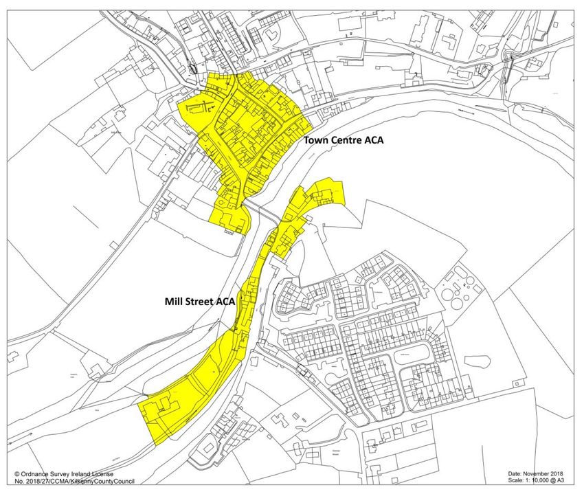
Thomastown Local Area Plan 2019
7.0       Green Infrastructure & Recreation ........................................................................................... 31
   7.1       GREEN INFRASTRUCTURE ..................................................................................................... 31
   7.2       OPEN SPACE .......................................................................................................................... 32
8.0       Built & Natural Heritage ............................................................................................................ 34
   8.1       ARCHITECTURAL HERITAGE................................................................................................... 34
   8.2       ARCHITECTURAL CONSERVATION AREAS (ACAs) .................................................................. 35
   8.3       ARCHAEOLOGICAL HERITAGE ............................................................................................... 37
   8.4       NATURAL HERITAGE & BIODIVERSITY ................................................................................... 39
9.0       Movement & Transport ............................................................................................................ 42
   9.1       WALKING & CYCLING (Active Travel) .................................................................................... 42
   9.2       PUBLIC TRANSPORT .............................................................................................................. 43
   9.3       ROADS & STREET NETWORK ................................................................................................. 44
   9.4       CAR & BICYCLE PARKING ....................................................................................................... 45
10.0      Infrastructure & Environment................................................................................................... 47
   10.1      WATER................................................................................................................................... 47
   10.2      WASTEWATER ....................................................................................................................... 47
   10.3      SURFACE WATER & GROUND WATER ................................................................................... 48
   10.4      FLOOD RISK MANAGEMENT ................................................................................................. 49
   10.5      ENERGY AND COMMUNICATIONS ........................................................................................ 50
11.0      Urban Design ............................................................................................................................. 52
   11.1      URBAN DESIGN...................................................................................................................... 52
   11.2      URBAN DESIGN PRINCIPLES .................................................................................................. 52
   11.3      MASTERPLAN LANDS............................................................................................................. 52
12.0      Implementation & Development Management Standards ...................................................... 56
   12.1 IMPLEMENTATION STRATEGY................................................................................................... 56
   12.1      DEVELOPMENT MANAGEMENT ............................................................................................ 56
   12.3 INFRASTRUCTURE DELIVERY SCHEDULE ................................................................................... 57
Appendix A: Land Use Zoning Objectives ............................................................................................. 58
Appendix B: Record of Protected Structures ........................................................................................ 62
Appendix C: Record of Monuments & Places ....................................................................................... 66
Appendix D Menu of appropriate Objectives/Policies for Water Services in development plans ....... 67

Thomastown Local Area Plan 2019

1.0      Introduction
1.1    LOCAL AREA PLAN STATUS AND PROCESS
The Thomastown Local Area Plan 2019‐2025 (LAP) has been prepared in accordance with the
requirements and provisions of the Planning and Development Act, 2000 (as amended). It sets out
an overall strategy for the proper planning and sustainable development of Thomastown in the
context of the Kilkenny County Development Plan 2014‐2020 (CDP), the National Planning
Framework, as published, and the Draft Regional Spatial and Economic Strategy. It is informed by
Ministerial Guidelines issued pursuant to Section 28 of the Planning and Development Act 2000 (as
amended). The legislative requirements regarding Strategic Environmental Assessment (SEA) and
Appropriate Assessment (AA) have been fulfilled throughout the plan preparation process. The LAP,
once adopted, will replace the Thomastown Local Area Plan 2009 (as extended).

1.2    REQUIREMENT TO PREPARE LOCAL AREA PLAN
Sections 18 ‐ 20 of the Planning and Development Act 2000 (as amended), provide that a local area
plan shall be made in respect of an area where the population is in excess of 1,500 people. It is
therefore mandatory to produce a Local Area Plan for the town of Thomastown, which at the last
census (2016) had a population of 2,445 persons.

1.3    FORM AND CONTENT OF THE LOCAL AREA PLAN
The Plan consists of a written statement with accompanying maps and associated environmental
reports. The written statement shall take precedence over the maps should any discrepancy arise
between them. In the full interpretation of all objectives for Thomastown, it is essential that both
the County Development Plan (CDP) and the Local Area Plan (LAP) are read in tandem. Where
conflicting objectives arise between the CDP and the LAP, the objectives of the CDP shall take
precedence. General development management standards are contained in the CDP, while policies
and objectives that are specific to Thomastown are included in the LAP.

1.4    PUBLIC CONSULTATION
The review of the Thomastown Local Area Plan 2009 commenced in June 2018 with a Pre‐draft
public consultation phase. Kilkenny County Council published a background Issues Paper and invited
submissions and observations from interested parties. Following the publication of both the Draft
plan and Material Alterations to same, submissions were also received from residents, service
providers, from local community and recreation groups and landowners during the statutory period
for submissions. These submissions to the pre‐draft stage, the Draft plan and the Material
Alterations to the Draft plan informed the final Local Area Plan.

1.5    ENVIRONMENTAL ASSESSMENTS
The preparation of this Local Area Plan has been informed by the preparation of a Strategic
Environmental Assessment (SEA) Screening Report in accordance with the Planning and
Development (Strategic Environmental Assessment) Regulations 2004, and a Stage One Appropriate
Assessment Screening Report, pursuant to Article 6 of the Habitats Directive 94/42/EEC. Strategic
Flood Risk Assessment and Infrastructural Assessments have also informed the plan.

                                                                                         1|Page
Thomastown Local Area Plan 2019
1.5.1   Appropriate Assessment
Articles 6(3) and 6(4) of the Habitats Directive and Section 177 of the Planning and Development Act
2000 (as amended), require that any plan or project with the potential to impact on the integrity of a
Natura 2000 site must first be screened to determine if appropriate assessment of the plan or
project is required. In the event that the screening indicates that potential significant impacts cannot
be ruled out then the plan or project will require an appropriate assessment. Appropriate
Assessment means an assessment, based on the best scientific knowledge available, of the potential
impacts of a plan or project, wherever located, on the conservation objectives of any Natura 2000
site and the inclusion, where necessary, of mitigation or avoidance measures to preclude negative
effects. The impacts assessed must include the indirect and cumulative impacts of the plan or
project. Therefore whether a plan or project is located within, or is at a geographically remote area
from a Natura 2000 site, if significant impacts cannot be ruled out then the plan or project must be
subject to an appropriate assessment.

These objectives will apply to all plans and projects whether public or private and across all sectors
of development.

Appropriate Assessment
AAO1.1: To ensure that any plan or project within the functional area of the Planning Authority is
subject to appropriate assessment in accordance with the Guidance Appropriate Assessment of Plans
and Projects in Ireland – Guidance for Planning Authorities, 2009 and is assessed in accordance with
Article 6 of the Habitats Directive in order to avoid adverse impacts on the integrity and conservation
objectives of the site.

1.5.2   Strategic Environmental Assessment
Local Area Plans are also required to comply with the provisions of the Strategic Environmental
Assessment (SEA) Directive (2001/42/EC) as transposed into the Planning and Development Act, the
objective of which is to provide for a high level of environmental protection and to contribute to the
integration of environmental considerations into the preparation and adoption of plans.

                                                                                            2|Page
Thomastown Local Area Plan 2019
Strategic Environmental Assessment (SEA) is the formal, systematic evaluation of the likely
significant environmental effects of implementing a plan or programme before the decision is made
to adopt the plan or programme. The purpose is to “provide for a high level of protection of the
environment and to contribute to the integration of environmental considerations into the
preparation and adoption of plans and programmes with a view to promoting sustainable
development”. A Strategic Environmental Assessment Screening report was carried out for this LAP
and Proposed Material Alterations and it was considered that a full Strategic Environmental
Assessment was not required.
1.5.3 Infrastructural Assessment
Appendix 3 of the National Planning Framework (NPF) [Project Ireland 2040] sets out a methodology
for a two‐tier approach for zoning of land which must be informed by an Infrastructural Assessment
(IA). The NPF states that this IA must identify “the potential for delivery of the required services
and/or capacity to support new development must be identified and specific details provided by the
Planning Authority at the time of publication of both the draft and final development or local area
plan”. See also Section 4.3.3.
1.6 PLANNING POLICY
This Plan has been prepared having regard to National, Regional and Local policy documents,
including but not restricted to the following;
• National Planning Framework
• Implementation Roadmap for the National Planning Framework (2018)
National Development Plan 2018 ‐ 2027
• National Climate Change Adaptation Framework: Building Resilience to Climate Change
(2012)
• National Energy Efficiency Action plan 2009‐2020 (2009)
• National Renewable Energy Action Plan (2010)
• Actions for Biodiversity – Ireland’s National Biodiversity Plan 2011‐2016 (2011)
• National Broadband Plan 2012
• Water Services Strategic Plan: A Plan for the Future of Water Services
• Regional Planning Guidelines for the South East Region (RPGs) 2010‐2022
• Kilkenny County Development Plan 2014‐2020
• Kilkenny Local Economic & Community Plan (LECP) 2016‐2021
• Local Area Plans; Guidelines for Planning Authorities DECLG/DoAHG (2013)
• Manual for Local Area Plans DECLG/DoAHG (2013)
• Spatial Planning and National Roads Guidelines for Planning Authorities
1.6.1 Project Ireland 2040 – The National Planning Framework (2018)
The National Planning Framework (NPF) sets the overarching context for planning policy in Ireland
and has identified the requirement for growth of approximately one million additional people in
Ireland by 2040. This means planning for a substantial increase in the number of people and jobs on
the island of Ireland.
For the southern region assembly area which includes County Kilkenny this means:
340,000 ‐ 380,000 additional people i.e. a population of almost 2 million.
Around 225,000 additional people in employment i.e. 880,000 (0.875m) in total.
3|Page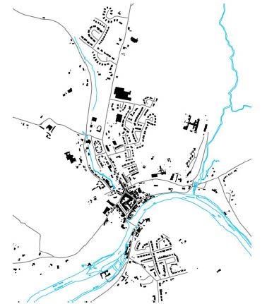
Thomastown Local Area Plan 2019
Under the objective of ‘Securing Compact and Sustainable Growth’, the NPF states that the physical
form of urban development in Ireland is one of our greatest national development challenges. It
states that more than anything else, getting the physical form and location of future development
right offers the best prospects for unlocking regional potential.

The strategy as set out in the NPF is ‘compact development’ that focuses on reusing previously
developed land. This requires focus on four key areas:

    1. The ‘liveability’ or quality of life of urban places;
    2. Making the continuous regeneration and development of existing built up areas as attractive
       and as viable as greenfield development;
    3. Tackling legacies such as concentrations of disadvantage in central urban areas;
    4. Linking regeneration and redevelopment initiatives to climate action.

The NPF includes the following national policy objectives which are relevant to the review of the
Thomastown LAP.

National Policy Objectives                                       LAP Response
National Policy Objective 3c: Deliver at least 30% of all new    Housing target will be delivered
homes that are targeted in settlements other than the five       within the existing built‐up footprint
Cities and their suburbs, within their existing built‐up
footprints.
National Policy Objective 4: Ensure the creation of              Mixed, connected and integrated
attractive, liveable, well designed, high quality urban places   communities.
that are home to diverse and integrated communities that
enjoy a high quality of life and well‐being.
National Policy Objective 6: Regenerate and rejuvenate           Improve resilience and design to
cities, towns and villages of all types and scale as             accommodate change
environmental assets, that can accommodate changing roles
and functions, increased residential population and
employment activity and enhanced levels of amenity and
design quality, in order to sustainably influence and support
their surrounding area.
National Policy Objective 7: Apply a tailored approach to       Focus on opportunities to reversing
urban development that will be linked to the Rural              the stagnation or decline of many
Regeneration and Development Fund.                              smaller urban centres, by identifying
                                                                strategic enabling projects that can
                                                                be funded through the Rural
                                                                Regeneration and Development
                                                                Fund.
National Policy Objective 17;                                   Appropriate conservation policies
Enhance, integrate and protect the special physical, social, included in the LAP for heritage
economic and cultural value of built heritage assets through assets
appropriate and sensitive use now and for future generations
National Policy Objective 18(b): Develop a programme for Identification of lands zoned for low
‘new homes in small towns and villages’ with local density to provide for serviced sites.
authorities, public infrastructure agencies such as Irish Water
and local communities to provide serviced sites with
appropriate infrastructure to attract people to build their
own homes and live in small towns and villages.

                                                                                           4|Page
Thomastown Local Area Plan 2019
National Policy Objective 54: Reduce our carbon footprint by Focus on opportunities to reduce the
integrating climate action into the planning system in demand for energy and use a better
support of national targets for climate policy mitigation and mix of low carbon energy sources.
adaptation objectives, as well as targets for greenhouse gas Measures to enhance sustainable
emissions reductions. travel will also reduce the need for
travel by car.
The NPF with the National Development Plan will also set the context for each of Ireland’s three
regional assemblies to develop their Regional Spatial and Economic Strategies taking account of and
co‐ordinating Local Authority County and City Development Plans in a manner that will ensure
national, regional and local plans align.
1.6.2 Regional Spatial and Economic Strategy for the Southern Region
The Southern Regional Assembly published the Draft Regional Spatial and Economic Strategy (RSES)
in December 2018. The South East Region Planning Guidelines 2010 – 2022 remain in effect until the
RSES is adopted. Whilst it is acknowledged that these remain in place, the Council will engender the
change required from the NPF and in particular the Implementation Roadmap (July 2018)
throughout the preparation of this LAP.
The principal purpose of the RSES is to support the implementation of the NPF and the economic
policies and objectives of the Government by providing a long‐term strategic planning and economic
framework for the development of Ireland’s regions.
The RSES is set to replace the South East Regional Planning Guidelines once adopted. The Issues
Paper for the Regional Spatial and Economic Strategy for the Southern Region promotes the region’s
significant potential for the development of an effective counter‐balance to the Greater Dublin Area,
driven by its regional cities, county towns and its broad rural base supported by an established and
resilient network of smaller towns and villages.
Key future planning and development and place‐making policy priorities for the Southern Region
include:
Emphasis on consolidating the development of places that grew rapidly in the past decade;
Preparing and implementing a regional rejuvenation priorities programme, to shape and
inform delivery of the Regeneration and Development Fund and identifying significant
ready‐to‐go city, rural town and village and rural rejuvenation priorities harnessing publicly
owned land and other assets that are not being used actively.
Harnessing the potential of the region in renewable energy terms across the technological
spectrum;
Developing a more integrated network of greenways, blueways and peatways to support the
diversification of rural and regional economies and promote more sustainable forms of
travel and activity based recreation.
Kilkenny’s District Towns of Thomastown, Castlecomer, Graiguenamanagh and Callan, along with the
smaller towns and villages, have growth potential in areas such as agriculture, food, energy and
tourism. These towns have the capacity for proportionate population growth utilising planned land
use and place‐making principles.
5|Page
Thomastown Local Area Plan 2019
1.6.3 Kilkenny County Development Plan 2014 ‐ 2020
The adopted development plan for County Kilkenny is the Kilkenny County Development Plan (CDP)
2014 ‐2020. The review of the Kilkenny CDP commenced in April 2018. The following six key issues to
be addressed by the CDP are:
Economic recovery; positioning of the county to avail of any economic upturn
Underpinning the settlement hierarchy within the county and compliance with the
requirements of the Regional Planning Guidelines through the core strategy.
Renewable energy strategy including wind energy policy
Continued protection of the natural and built heritage
Planning frameworks for smaller towns and villages
Identification of key infrastructure for the County to bolster its development
In line with the Core Strategy of the County Development Plan, Thomastown is classified as a District
Town in the County’s settlement hierarchy. It is an objective of the Core Strategy of the Kilkenny CDP
that District Towns “… will in so far as practical be self‐sufficient incorporating employment activities,
sufficient retail services and social and community facilities”.
In terms of economic development, the Kilkenny CDP has as its objectives for District towns:
“To ensure the sustainable development of the District towns in the County to achieve their
target populations and enhance their capacity to attract new investment in employment,
services and public transport for the benefit of their own populations and that of their rural
hinterlands.”
To promote a diverse and sustainable local economy through the designation of sufficient
lands for employment related uses, including facilities, to promote SME growth through the
local area plans for the District towns.”
6|PageThomastown Local Area Plan 2019
1.6.4 National Policy Requirements
In addition to the introduction of the National Planning Framework and RSES, a number of new
national policy requirements and legislative changes have been introduced since the preparation of
the previous Thomastown Local Area Plan in 2009.
1.6.5 Smarter Travel: A Sustainable Transport Future, 2009‐ 2020
Smarter Travel, A Sustainable Transport Future, is the transport policy for Ireland for the period
2009‐2020. This document sets out the transport policy for Ireland which, in addition to prudent
investment in new infrastructure, sets out necessary steps to ensure that people choose more
sustainable transport modes such as walking, cycling and public transport. This key national policy
has sustainability at its core and clearly indicates that future population and economic growth will
have to take place predominantly in sustainable, compact urban and rural areas which discourage
dispersed development and long commuting.
1.6.6 Interim Guidelines for Planning Authorities on Statutory Plans, Renewable Energy and
Climate Change – July 2017
These interim guidelines state that local authority development plans are a critical part of translating
overall national policy on energy, renewable energy and wind energy in a manner that supports the
achievement of Ireland’s international obligations relating to climate change and renewable energy,
and taking account of local circumstances. As provided for in section 10(2) (n) of the Planning and
Development Act (2000), as amended, Development Plans are required to include objectives to
mitigate against climate change and reduce reliance on fossil fuels.
1.6.7 National Climate Change Policy, 2013
The extent of the challenge to reduce Green House Gas (GHG) emissions in line with our
International and EU obligations is reflected in the National Policy Position on Climate Action and
Low Carbon Development (2014) and the Climate Action and Low Carbon Development Act 2015.
The National Policy Position establishes the fundamental national objective of achieving transition to
a competitive, low carbon, climate‐resilient and environmentally sustainable economy by 2050.
7|PageThomastown Local Area Plan 2019
It clarifies the level of GHG mitigation ambition envisaged; and establishes the process to pursue and
achieve the overall objective. Specifically, the National Policy Position envisages that policy
development will be guided by a long‐term vision based on:
• an aggregate reduction in carbon dioxide (CO2) emissions of at least 80% (compared to 1990
levels) by 2050 across the electricity generation, built environment and transport sectors
• in parallel, an approach to carbon neutrality in the agriculture and land‐use sector, including
forestry, which does not compromise capacity for sustainable food production.
1.6.8 The National Mitigation Plan, 2017
The measures proposed by the National Mitigation Plan lay the foundations for transitioning Ireland
to a low carbon, climate resilient and environmentally sustainable economy by 2050. The Plan
includes over 100 individual actions for various Ministers and public bodies to take forward as we
move towards implementation. Chapter 4 outlines proposals to ‘Decarbonise the Built Environment’,
with the overall objective of use less energy and for most of the energy to come from low or zero‐
carbon fuels. This can be achieved by ensuring that new buildings are low or “nearly zero emission”
standard and energy efficiency upgrades, known as retrofits, are carried out with respect to the
existing building stock. The mitigation plan states that ‘as well as expecting buildings to consume
much less energy, the mix of fuels providing that energy should be transitioning to a much lower
carbon content.’
1.6.9 National Adaptation Framework, Planning for a Climate Resilient Ireland, 2018
Ireland's first statutory National Adaptation Framework (NAF) was published in January 2018. The
NAF sets out the national strategy to reduce the vulnerability of the country to the negative effects
of climate change. The NAF was developed under the Climate Action and Low Carbon Development
Act 2015. In relation to the ‘Built Environment and Spatial Planning’ it states that;
“It is clear that climate change considerations need to be taken into account as a matter of
course in planning‐related decision making processes and that the deepening of adaptation
considerations in the planning and building standards processes is considered the most
appropriate way of increasing the resilience of the built environment”.
Integrating climate considerations into decision making should ensure that inappropriate forms of
development in vulnerable areas are avoided and compact development in less vulnerable areas is
promoted.
Other considerations include the spatial implications of water stress. Land use policies may also
facilitate the conversion or maintenance of land at risk of flooding to less vulnerable uses (e.g. parks,
gardens and open spaces for natural habitats, etc.).
Local Authorities are required to prepare Adaptation Strategies and the Guidelines1 for their
preparation recommend that, once approved, strategies should be used to assess the adaptation
fitness of spatial plans and ensure that climate change adaptation considerations are mainstreamed
into the process. The Adaptation Strategy for Kilkenny is currently in preparation.
1
The Local Authority Adaptation Strategy Development Guidelines (2016)
8|PageThomastown Local Area Plan 2019
1.6.10 Other Plans and Policies
1.6.10.1 Kilkenny Local Economic and Community Plan 2016 ‐ 2021
A Local Economic and Community Plan (LECP) for Kilkenny was published in February, 2015 and
provides a road map for the development of our county to 2021. One of the main objectives of the
LECP is to ensure the effective co‐ordination of publicly funded programmes. As a statutory plan, the
LECP will provide a blueprint for local and community development funding invested in County
Kilkenny over the plan period.
9|PageThomastown Local Area Plan 2019
2.0 Thomastown in Context
2.1 LOCATIONAL CONTEXT
Thomastown is one of County Kilkenny’s largest district towns, located at the crossing of the R448
(former N9) and the R700 from Kilkenny to New Ross and the R703 from Thomastown to
Graiguenamanagh. The town is located approximately 16km south west of Kilkenny City and 32km
north east of Waterford City. The Mount Juliet Estate with Hotel and Championship Golf Club lies ca.
6.5km to the east of the town.
Thomastown also benefits from being located on the main Waterford/Dublin train line with a
number of bus routes also passing through the town.
Figure 2.1: Locational Context of Thomastown
2.2 HISTORICAL DEVELOPMENT
Thomastown was named after Thomas Fitzanthony Walsh, Anglo‐Norman Seneschal of Leinster ‐ the
Irish name being Baile Mhic Andain (Town of the son of Anthony). Thomas Fitzanthony Walsh is
recognised for his role in commissioning the 13th century wall around the town fortified by 14
towers, primarily to protect the religious house and castle built therein. The ruins of the church and
an ancient High Cross still exist. The town was originally called Grennan but it was later renamed
Thomastown after its founder.
10 | P a g eThomastown Local Area Plan 2019
The medieval town of Thomastown developed from its location as an important crossing point on
the River Nore. During the first 100 years or so the settlement grew to about 1,000 persons, secured
by the town wall. An area of approximately 16 acres was enclosed within the walls and it developed
as an important market town for the rural hinterland. Livestock and farm produce were sold there
until the mid‐1950s in the main street (i.e. Market Street). Whereas the northern and eastern walls
have now been lost, much of the western range survives (although in poor condition).
Other surviving features of the town’s medieval defences are the Castle and the Tower House on
either side of the Bridge, the remains of a circular tower on the western side and, behind the tennis
court, a square tower which formed the North West corner of the defences.
Grennan Castle, to the South of the town on the banks of the River dates to the 13th century and
comprises a 3‐storey Norman structure, which remained in good repair until the beginning of the
19th century.
Figure 2.2: Urban Structure
11 | P a g eThomastown Local Area Plan 2019
3.0 The Vision for Thomastown
3.1 DEVELOPMENT PRINCIPLES
The preparation and formulation of this LAP is underpinned by the following development
principles;
3.2 STRATEGIC VISION
This LAP is underpinned by a Strategic Vision which is intended to guide the future growth of the
town in a sustainable manner, recognising its natural and built assets, and enhancing the town’s
character, heritage and amenities.
The Strategic Vision is based on detailed analysis of the profile, functions and activities of
Thomastown in line with its position in the County Settlement Hierarchy:
‘This Local Area Plan will promote the proportionate growth of Thomastown to
maintain its share of the County population, approaching a population of 2,800
by 2026, building on its established character and consolidating its role as a
District Town. To achieve this, the Plan will encourage population growth that is
based on the capacity of physical and social infrastructure. Thomastown will be
supported as a vibrant service centre, and the Plan will encourage job creation,
capitalising on local strengths including heritage and tourism. The Plan will
promote sustainable movement and identify opportunities to enhance
connectivity with particular regard to the train station. Development will be
encouraged in a sustainable manner that promotes both a healthy environment
and healthy living, and protects the unique heritage of the area’.
3.3 STRATEGIC OBJECTIVES
The strategic objectives set out below set parameters and mechanisms which will drive the Local
Area Plan towards achieving the vision for the town during the plan period and beyond.
The Strategic Vision, principles and objectives are expanded upon in the specific objectives and
actions contained throughout this plan.
12 | P a g eThomastown Local Area Plan 2019
SO1: To provide for the proportionate growth of Thomastown to maintain its 2.46% of the County’s
population allocation to 2026 in accordance with the National Planning Framework and the County
Development Plan Settlement Strategy.
SO2: To promote and support economic development that capitalises on the town’s location in close
proximity to Kilkenny City, with the heritage and tourism assets being identified as key economic
strengths for the town.
SO3: To facilitate the development of high quality, integrated residential neighbourhoods that cater
for an appropriate demographic mix and deliver, where possible, community, recreation and amenity
facilities in tandem with housing and to encourage through new development and road schemes,
improvements to enhance the approach roads to the town.
SO4: To support the creation of network of walkways and open spaces connecting the river and other
recreational and tourist attractions within the town.
SO5: To enhance and protect Thomastown’s built and natural heritage by promoting the
enhancement, management and understanding of these assets whilst encouraging sensitive and
sustainable development so as to ensure its survival for future generations.
SO6: To improve the quality of the existing transport network in the town to increase permeability
and connectivity in order to provide universal access to key land uses such as the train station,
community facilities, including schools and sports clubs, and new and existing development lands.
SO7: To phase future growth in line with the capacity of supporting physical infrastructure and to
ensure that it occurs in accordance with proper planning and sustainable development.
SO8: To ensure development proposals conform to best practice urban design principles to deliver
well planned and integrated development including renewal and regeneration that will enhance the
town and improve the quality of life of its residents.
SO9: To phase new development to ensure that it occurs in an orderly and efficient manner in
accordance with proper planning and sustainable development.
13 | P a g eThomastown Local Area Plan 2019
4.0 Core Strategy & Zoning
SO1: To provide for the proportionate growth of Thomastown to maintain its 2.46% share of the
County’s population allocation to 2026 in accordance with the National Planning Framework and
the County Development Plan Settlement Strategy.
4.1 CURRENT POPULATION
The population of Thomastown was 2,445 persons in the 2016 census, of which males numbered
1,182 and females numbered 1,263. This represents an increase of 7.6% from the 2011 census which
was 2,273.
Table 4.1: Census of Population 1996 ‐ 2016
1996 2002 2006 2011 2016
Thomastown 1,581 1,600 1,837 2,273 2,445
The 2016 Census recorded an increase of 7.6% on the 2011 census to a total population of 2,445
persons which was below the levels of growth experienced during the two previous intercensal
periods (24% between 2006 and 2011 and 14.8% between 2002 and 2006).
4.2 POPULATION PROJECTIONS
The population targets for County Kilkenny are set by the National Planning Framework (NPF) and
the Implementation Roadmap for the National Planning Framework (July 2018). The transitional
Regional and County Population Projections for County Kilkenny are set out in Table 4.2 below for
2026 and 2031.
Table 4.2: Transitional Population Projections for County & Thomastown
Population 1996 2002 2006 2011 2016 2026
Thomastown 1,581 1,600 1,837 2,273 2,445 2,710
Kilkenny County 75,336 80,399 87,558 95,419 99,232 110,000
4.3 PROPOSED CORE STRATEGY
4.3.1 Housing Requirement
The Planning Authority, during the preparation of development plans and local area plans are
required to ensure that sufficient land is zoned for residential use to cater for the projected
population for the town over the lifetime of the plan. The population of Thomastown in the 2016
census was 2,445 persons. The 2014 CDP states that District towns would retain their percentage
allocation to 20202. Thomastown retained and also marginally increased its proportion in the 2011‐
2016 intercensal period to 2.46%. Such growth equates to an additional population of 265 persons
over the Plan period. The housing requirement for this plan is therefore to provide for ca. 100
2
Ref Table 3.4 of the Kilkenny County Development Plan
14 | P a g eThomastown Local Area Plan 2019
additional housing units over the lifetime of the plan3 to accommodate the projected population
growth.
It is important to note that the LAP will also make provision for social housing within the town,
through Part V, Local Authority and Voluntary Housing developments. Following consultation with
the Housing Section of the Council, it is estimated that ca. 62 units are required for people who are
currently resident in the town and therefore do not represent population growth in the context of
the Core Strategy. Units contributing towards meeting the social housing for such persons already
living in Thomastown will therefore not be included as part of the proposed 100 units but will be
added to same. Therefore, this LAP will provide for a total housing unit requirement of 162 units
(See Table 4.3 below).
It is envisaged that a percentage of the social housing units will be provided by means of Part VIII
Council development at Newtown (ca. 20 units) and through the delivery of Part 5 housing across
the plan area (ca. 10 units4).
Table 4.3: Estimated Residential Capacity
Location Quantum of land for Estimated Residential Density
Housing (ha) Capacity
NR1 – Ladyswell Street 3.7 74 20/ha
NR2 – Grennan/Newtown 1 20* 20/ha
NR3 – Dublin Road 2 40 20/ha
LD 1 ‐ Cloughabrody 1.7 18** 10/ha
LD2 ‐ Cloughabrody 0.8 8** 10/ha
160 units
* Reflects housing to be provided for persons already resident in Thomastown
** To address NPO 18b (serviced sites)
The density of development and number of units permissible will be determined at detailed design
stage based on a full assessment of site characteristics and local sensitivities.
4.3.2 New Residential Zoning
In accordance with the Core Strategy it is anticipated that ca. 100 housing units will be required up
to 2026, with an estimated 62 additional units required to address the social housing requirements
over the period of the Plan. The remainder is to be provided for on existing residentially zoned lands
and under Part V proposals. To facilitate such growth, this LAP proposes to zone 6.7 ha of lands for
‘New Residential’ development based on a general minimum density of 20 units/ha. It should also be
noted that there will be opportunities to provide infill developments comprising small residential or
mixed use schemes on existing residentially or mixed use zoned lands across the LAP area.
The plan allows for housing within the existing footprint of the town and the Council will seek to
deliver housing in a compact form through measures such as the Vacant Site Levy and Derelict Sites
Act. The Council has taken a sequential approach to the zoning of land.
It should also be noted that National Planning Framework; National Policy Objective (NPO) 18b sets
out a requirement to ‘develop a programme for ‘new homes in small towns and villages’ with local
authorities, public infrastructure agencies such as Irish Water and local communities to provide
3
Applying an average occupancy of 2.7 persons per household
4
10% of all housing proposals subject to Part 5
15 | P a g eThomastown Local Area Plan 2019
serviced sites with appropriate infrastructure to attract people to build their own homes and live in
small towns and villages”. In this regard, ca. 2.5 ha of land will be identified in this LAP to facilitate
ca. 20 houses at 10 houses to the hectare. These houses are additional to the core strategy
projection.
4.3.3 Infrastructural Assessment
In accordance with the requirement of the National Planning Framework (NPF) an Infrastructure
Assessment (IA) has been completed for the plan area. This Infrastructural Assessment is based on
the potential for delivery of the required services and/or capacity to support new development and
is also aligned with the approved infrastructural investment programme of the relevant delivery
agency(ies) or be based on a written commitment by the relevant agency(ies) to provide the
required infrastructure within a specified timescale.
The NPF requires a two‐tier approach to the Infrastructure Assessment which is set out as follows:
Tier 1: Serviced Zoned Land; comprising lands that are able to connect to existing development
services, i.e. road and footpath access including public lighting, foul sewer drainage, surface water
drainage and water supply, for which there is service capacity available, and can therefore
accommodate new development.
Tier 2: Serviceable Zoned Land; comprises lands that are not currently sufficiently serviced to
support new development but have potential to become fully serviced within the life of the plan.
Further statutory guidance is awaited under Section 28 of the Planning and Development Act and
the IA methodology is therefore not fully developed. Notwithstanding this absence of statutory
guidance, following consultation with Irish Water in particular, land proposed for residential zoning
within this LAP was considered against the Tier 1 and Tier 2 Infrastructure Assessment criteria set
out in the NPF. The plan relied on a traffic light system (red, amber and green) to identify lands that
are most suitable according to the tiered approach and in that way aims to align the zoning with the
investment priorities of the agency. The assessment was completed as a desk based study and
currently excludes an estimate in relation to the full cost of delivery of the required infrastructure.
The Infrastructure Assessment however only addresses a single site suitability criterion, which has to
be considered in combination with further criteria to determine suitability when prioritising land for
zoning. The Infrastructure Assessment was therefore included in a higher order Housing Lands
Assessment Matrix, which includes further high level criteria such as “Compact Growth” and
“Physical Suitability”. This assessment matrix is again based on a traffic light system, which, when
considering the various elements of each criterion, is considered the most suitable methodology.
4.4 ZONING
The “Thomastown Land Use Zoning” map (Map 1) demonstrates the zoning of particular lands. For
accepted uses with each zoning category, Appendix A should be consulted. The list outlines
appropriate uses for which may be permissible or open for consideration in each zoning category
and is not intended to be exhaustive. Other uses may be acceptable provided that the Planning
Authority consider that they do not contravene the zoning objective.
16 | P a g eThomastown Local Area Plan 2019
4.5 CORE STRATEGY POLICY & OBJECTIVES
Core Strategy
CS1: It is the policy of the Council to support the sustainable long‐term growth of Thomastown and
continued consolidation of development within the town boundary.
Objectives
It is an objective of the Council
CSO1.1: To support and facilitate development on zoned lands at appropriate locations and deliver at
least 30% of all new homes within the existing built‐up footprints in Thomastown to satisfy the
housing needs of the town over the period of the plan.
CSO1.2: To provide for serviced sites with appropriate infrastructure in accordance with Objective 18
(b) of the National Planning Framework ca. 2.8ha of land has been identified in this LAP to facilitate
such a proposal.
CSO1.3: To implement the zoning objectives set out in Appendix A of this LAP.
CSO1.4: To manage the provision of one off housing on lands zoned as ‘Agriculture’. Limited one off
housing will be permitted in accordance with the policy set out under Section 6.4.
17 | P a g eThomastown Local Area Plan 2019
5.0 Economic Development & Employment
SO2: To promote and support economic development that capitalises on the town’s location in
close proximity to Kilkenny City, with the heritage and tourism assets being identified as key
economic strengths for the town.
5.1 ECONOMIC CONTEXT
The CDP recognises that the identity and economic development of County Kilkenny, including the
district town of Thomastown, are intrinsically linked to its heritage, and acknowledge that the
county’s character and culture are vital assets that help the county compete as a tourism destination
and a choice for location for investment.
In the context of Thomastown’s designation as a District Town in the County Development Plan, this
LAP supports enterprise and employment development in Thomastown and identifies a potential
town centre expansion site at Ladywell Street including a permitted Primary Care Unit and also the
vacant former Supervalu premises at Marshes Street. Enterprise and employment uses such as
professional services, public administration, research and development and other commercial
activities have the potential to revitalise the town centre. The town also benefits from the presence
of a Kilkenny County Council District Office and a Garda District Headquarters.
The creative sector has a strong tradition in Thomastown and with supports from this LAP and other
policy and funding opportunities, can reach its potential in the development of skills and enterprise
to bring real benefit to the local economy.
This LAP also makes provision for industrial development and other employment uses to the north of
the town, at a location which provides easy access to the national road network and existing
infrastructural services.
5.2 ECONOMIC DEVELOPMENT
Thomastown is located ca. 16km to the south east of Kilkenny City and c. 30km north of Waterford
City. With the emergence over the last ten years of relatively high quality transport infrastructure,
both road and rail, to employment bases beyond those two locations, the town is likely to continue
to have a strong commuting role. Thomastown’s main role is as a district service centre for the town
18 | P a g eThomastown Local Area Plan 2019
and its wider hinterland. Existing businesses in the town include Banks, Credit Union, Pharmacies,
Hardware Stores, Craft Shops, Restaurants and Coffee Shops. Whilst all of these components create
the foundations for a successful town centre, further and diversified local employment will also be
necessary to support a vibrant, sustainable and attractive town which maximises retention of its
working population.
The employment ratio of 0.682 for Thomastown as set out in Appendix 2 of the NPF (Population and
Employment in Urban Settlements in the Southern Regional Assembly area) suggests that the ratio
of jobs to workers in Thomastown is somewhat below the 1.06 average for the region. Accordingly
the LAP focuses on supporting the creation and continued maintenance of local employment as well
as facilitating sustainable transport initiative in order to improve ease of access to and from
Thomastown, supporting commercial/tourist activities and ease of access to neighbouring
employment centres. Also, in order to facilitate employment initiatives, a significant area of land has
been zoned for industrial development to the north of the town and there is also significant
development capacity the mixed use lands at Ladyswell Street. In addition to these there is
acknowledged capacity for employment generating uses, primarily service sector jobs that can
currently be accommodated within the town centre.
The LAP, in addition to encouraging a strengthened role for the town centre, identifies lands for
industrial development on the Dungarvan Road and in particular will support and encourage the
continued growth of the Creative Arts, Cultural and food economy in the town through the
established and growing School of Food, Grennan Craft Mill, Pottery Skills School and Grennan
Equestrian College.
ED 1: Enterprise and Economic Development Policy
It is the policy of the Council to support sustainable economic development in Thomastown,
optimising on the town’s location in proximity to the urban centres of Kilkenny and Waterford Cities
and its significant potential as a heritage and tourism destination.
Objectives
It is an objective of the Council:
EDO1.1: To ensure that there is a sufficient supply of zoned lands at suitable locations in the town
to accommodate a range of enterprise and employment development types.
EDO1.2: To support the provision of Incubation Space and Hot‐desking facilities within the town
with work stations/areas for start‐up businesses and remote workers, particularly those in the
creative/digital sphere and start‐up companies that can contribute to the tourism or arts economy.
EDO1.3: To support industrial and warehousing development on lands zoned for “Industry”.
5.3 TOWN CENTRE
Thomastown’s Town Centre defines the character and attractiveness of the town with the narrow
streets, attractive buildings and traditional shop fronts, many of which are listed on the Record of
Protected Structures. The town has evolved since the early 18th century and remains the focus for a
broad range of commercial and community activities. In recent years new retail developments of Lidl
and Supervalu (which also now accommodates the Post Office and a pharmacy) on the periphery of
the town centre have altered the dynamic of the town centre and drawn activity away from Main
Street.
19 | P a g eThomastown Local Area Plan 2019
5.4 TOWN CENTRE REGENERATION STRATEGY
The most recent evolution is the rise of the café culture on Market Street, which ignites the vitality
of the town centre for those who work, visit and indeed live in the town. Similar to many traditional
town centres, the role of the main street as the dominant location for convenience and comparison
retail has been challenged by more recent retail developments outside of the historic core. However,
the town centre continues to fulfil an important role as a public place, with a diversity of uses, and
with opportunities to further diversify in order to serve the needs of a growing population and to
realise the town’s heritage potential. This LAP seeks to support the primacy of the town centre as
the focus for future retail, commercial activity and community life and to attract activity back to the
Main Street. In order to reinforce the town centre as a viable and vibrant centre, a mix of retail and
commercial, civic, social and cultural uses, is encouraged in addition to residential development. It is
a key priority of this LAP to prevent further internal retail leakage to locations outside of the historic
core of the town. The consolidation of development in the town centre area and enhanced
connectivity within the town centre through enhanced car parking facilities and signage to same is
therefore encouraged.
5.4.1 THOMASTOWN REGENERATION PROJECT
National Policy Objective 16 of the National Planning Framework sets out to ‘target the reversal of
rural decline in the core of small towns and villages through sustainable targeted measures that
address vacant premises and deliver sustainable reuse and regeneration outcomes’. Kilkenny County
Council, in association with Kilkenny Leader Partnership, National Design and Craft Council of
Ireland, Thomastown Community Network and Thomastown Community Centre have collaborated
to develop the ‘Thomastown Regeneration Project’. This project seeks to redefine Thomastown
Town Centre with the provision of modern library services, flexible creative and arts spaces,
improved public realm and tourism facilities, town centre living space and enterprise opportunities.
The regeneration project is based around 5 projects that combine to create investment of scale that
will significantly contribute to the rural economy of the town.
The 5 projects include;
A digital enterprise hub for Thomastown to facilitate the occupation of the current Library
by the Men’s Shed to develop a social enterprise,
Environmental upgrades to existing streetscape with high quality paving materials and street
furniture to enhance the visual appearance of the street,
Renovation of the former Court House (Sessions House) into a Craft and Design Centre in
conjunction with the Design & Crafts Council of Ireland,
Upgrade to the Quayside Car Park to include bus parking and
Regeneration of Maudlin Street.
Overall, the project aims to re‐purpose two significant town centre buildings for creative, cultural
and enterprise uses which will deliver a range of benefits socially, economically, historically and
culturally for the town. This LAP supports the delivery of this overall project and any proposals that
facilitate same.
In addition to the foregoing, Kilkenny County Council actively pursued the relocation of the existing
library to a modernised Library facility in the building which adjoins the Community Centre. Funding
has been secured under the Town and Village Renewal Scheme (2018) to complete same. As part of
this project, the Men’s Shed, which is currently located at the Community Centre, will also relocate
to the existing library premises on Marshes Street. By moving locations, the Library and Men’s Shed
20 | P a g eYou can also read