HARRY GWALA DISTRICT MUNICIPALITY - ENVIRONMENTAL MANAGEMENT FRAMEWORK DESIRED STATE REPORT - Nemai Consulting
←
→
Page content transcription
If your browser does not render page correctly, please read the page content below
HARRY GWALA DISTRICT MUNICIPALITY
 ENVIRONMENTAL MANAGEMENT FRAMEWORK

         DESIRED STATE REPORT

                DRAFT

             November 2018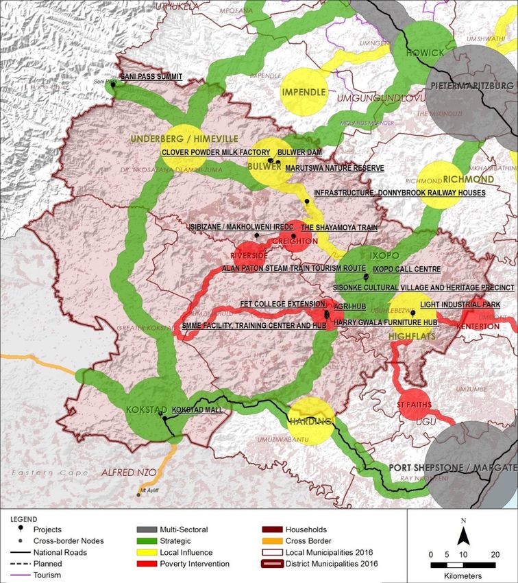
uMkhomazi River
TITLE AND APPROVAL PAGE
Project Name: Harry Gwala District Municipality Environmental Management Framework
Report Title: Desired State Report
Authority Reference: N/A
Report Status Draft
Client:
Prepared By: Nemai Consulting
+27 11 781 1730 147 Bram Fischer Drive,
+27 11 781 1731 FERNDALE, 2194
donavanh@nemai.co.za PO Box 1673, SUNNINGHILL,
www.nemai.co.za 2157
Report Reference: 10627–20181130 R-PRO-REP|20150514
Authorisation Name Date
Author: D. Henning 30/11/2018
Reviewed By: N. Naidoo 30/11/2018
This Document is Confidential Intellectual Property of Nemai Consulting C.C.
© copyright and all other rights reserved by Nemai Consulting C.C.
This document may only be used for its intended purpose
Harry Gwala District Municipality                            EMF: Desired State Report (Draft)

                            AMENDMENTS PAGE
                                                                              Amendment
     Date:                             Nature of Amendment
                                                                               Number:
30/11/2018           First Version for public review                                0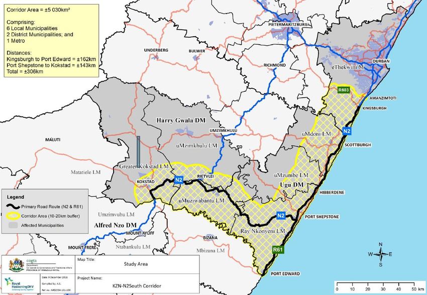
Harry Gwala District Municipality                           EMF: Desired State Report (Draft)

                          EXECUTIVE SUMMARY
The Harry Gwala District Municipality (HGDM), in partnership with the KwaZulu-Natal (KZN)
Department of Economic Development, Tourism and Environmental Affairs (EDTEA),
embarked on a process to develop an Environmental Management Framework (EMF) for the
District. An EMF is a study of the biophysical and socio-cultural systems of a geographically
defined area to reveal where specific activities may best be practiced and to offer
performance standards for maintaining appropriate use of such land.

The EMF development approach, which is outlined in the figure to follow, is consistent with
the requirements stipulated in the National Environmental Management Act (Act No. 107 of
1998) and the EMF Regulations (Government Notice No. R547 of 18 June 2010).

                             Outline of EMF Development Process

November 2018                                                                               i
Harry Gwala District Municipality EMF: Desired State Report (Draft) This report represents the Desired State assessment (Volume 2) of the HGDM EMF process and serves to build on the status quo evaluation by establishing an environmental vision for the District which is translated into a spatial representation via a mapping exercise. In order to address the triggers for sustainable development in HGDM some of the key objectives of the EMF include facilitating environmental decision-making and providing strategic guidance on environmental, economic and social issues in the District. The catalysts for initiating the EMF fall within the following categories: 1. Significant environmental factors; 2. Development pressures and trends; 3. Environmental threats; and 4. Resource management issues. The approach to defining a desired state in HGDM is based on interpreting and integrating the following: Management priorities; Sensitivity analysis; Development pressures and trends; Development opportunities and constraints; and Aspirations of Interested and Affected Parties. An Environmental Management Zone (EMZ) represents a specific demarcated area that requires active control to ensure that its potential is realised and sensitive features are adequately safeguarded. The following EMZs were delineated for HGDM: Formally Protected Areas; Conservation Buffers; Terrestrial Biodiversity; Aquatic Biodiversity; Agriculture; Heritage; Urban Areas; and Traditional Authorities. To facilitate the attainment of the desired state for the EMZs, Management Guidelines will be included in the Strategic Environmental Management Plan (SEMP) which will stipulate compatible activities that support the vision for these zones and specific management requirements and objectives that need to be adhered to when development is proposed in a zone. November 2018 ii
Harry Gwala District Municipality                          EMF: Desired State Report (Draft)

                           TABLE OF CONTENTS
1     INTRODUCTION                                                                              1

1.1    Background                                                                               1

1.2    EMF Study Area                                                                           2

1.3    EMF Objectives                                                                           5

1.4    EMF Development Principles                                                               5

1.5    EMF Development Approach                                                                 6

1.6    Establishing a Desired State                                                             7

1.7    Gaps, Assumptions and Limitations                                                  10

2     DEVELOPMENT PRESSURES & TRENDS                                                      12

2.1    Introduction                                                                       12

2.2    Provincial Planning                                                                12
  2.2.1 Provincial Growth and Development Strategy                                        12
  2.2.2 Provincial Spatial Economic Development Strategy                                  13
  2.2.3 KZN-N2 South Corridor                                                             17

2.3    Local Planning                                                                     18
  2.3.1 Harry Gwala District Growth and Development Plan                                  18
  2.3.2 Development Corridors                                                             19
  2.3.3 Nodal Development                                                                 20

3     DEVELOPMENT OPPORTUNITIES & CONSTRAINTS                                             23

3.1    Introduction                                                                       23

3.2    Agriculture                                                                        23

3.3    Tourism                                                                            24

4     MANAGEMENT PRIORITIES                                                               27

4.1    Visioning                                                                          27
  4.1.1 General                                                                           27
  4.1.2 Provincial Context                                                                27
  4.1.3 Local Context                                                                     29

4.2    Sustainability Criteria                                                            31

November 2018                                                                             iii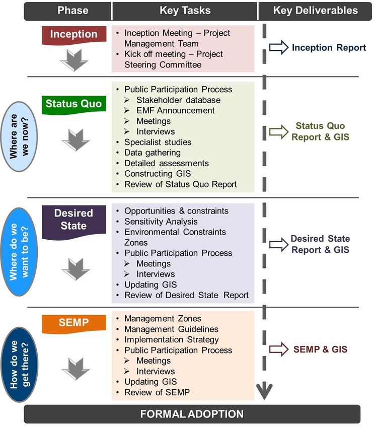
Harry Gwala District Municipality                        EMF: Desired State Report (Draft)

4.3    Environmental Management Priorities                                              32
  4.3.1 Feature-based Management Priorities                                             32
  4.3.2 Management Priorities Expressed by Interested and Affected Parties              38
  4.3.3 Future Pursuit of Management Priorities                                         43

5     SENSITIVITY ANALYSIS                                                              44

5.1    Introduction                                                                     44

5.2    Determining Sensitivity per Environmental Feature                                44

5.3    Agriculture                                                                      46
  5.3.1 Governance Framework                                                            46
  5.3.2 Local Context                                                                   46
  5.3.3 EMF Spatial Considerations                                                      47
  5.3.4 Sensitivity Ratings                                                             49

5.4    Terrestrial Biodiversity                                                         50
  5.4.1 Governance Framework                                                            50
  5.4.2 Local Context                                                                   51
  5.4.3 EMF Spatial Considerations                                                      52
  5.4.4 Sensitivity Ratings                                                             56

5.5    Aquatic Biodiversity                                                             57
  5.5.1 Governance Framework                                                            57
  5.5.2 Local Context                                                                   58
  5.5.3 EMF Spatial Considerations                                                      58
  5.5.4 Sensitivity Ratings                                                             60

5.6    Slope                                                                            61
  5.6.1 Governance Framework                                                            61
  5.6.2 Local Context & EMF Spatial Considerations                                      61

5.7    Heritage                                                                         63
  5.7.1 Governance Framework                                                            63
  5.7.2 Local Context                                                                   64
  5.7.3 EMF Spatial Considerations                                                      64
  5.7.4 Sensitivity Ratings                                                             65

5.8    Overall Environmental Sensitivity in HGDM                                        66

6     ENVIRONMENTAL MANAGEMENT ZONES                                                    67

6.1    Delineating Environmental Management Zones                                       67

6.2    Managing Conflicts between Development and Environmental Features                67

6.3    Mapping EMZs                                                                     68

November 2018                                                                           iv
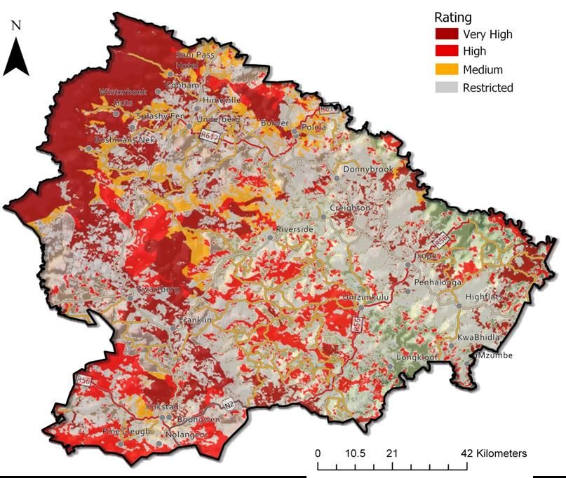
Harry Gwala District Municipality                                EMF: Desired State Report (Draft)

7    REFERENCES                                                                                 78

LIST OF TABLES

Table 1:     Catalyst Projects for HGDM linked to PSEDS                                          15
Table 2:     HGDM corridor hierarchy based on SDF (draft 1)                                      20
Table 3:     HGDM Nodal Hierarchy                                                                21
Table 4:     Opportunities and Constraints associated with Agriculture in HGDM                   23
Table 5:     Opportunities and Constraints associated with Tourism in HGDM                       25
Table 6:     HGDM’s Environmental Management Priorities                                          32
Table 7:     Focus Group Meetings – EMF Desired State Phase                                      38
Table 8:     Views expressed during the Focus Group Meetings                                     39
Table 9:     Environmental Sensitivity Scale                                                     45
Table 10:    Legal Framework for Agriculture                                                     46
Table 11:    A detailed table of the agricultural land catergory classes for KZN                 47
Table 12:    Sensitivity Ratings assigned to Category: Agriculture                               49
Table 13:    Legal Framework for Terrestrial Biodiversity                                        50
Table 14:    Land Use Management Objectives for Terrestrial & Aquatic Conservation Categories    54
Table 15:    Land Use Management Objectives for the WHS Buffer Zone Categories                   55
Table 16:    Sensitivity Ratings assigned to Category: Terrestrial Biodiversity                  56
Table 17:    Legal Framework for Aquatic Biodiversity                                            57
Table 18:    Sensitivity Ratings assigned to Category: Aquatic Biodiversity                      60
Table 19:    Sensitivity Ratings assigned to Category: Terrain                                   62
Table 20:    Legal Framework for Historical and Cultural Features                                63
Table 21:    Sensitivity Ratings assigned to Category: Heritage                                  65

LIST OF FIGURES

Figure 1:    EMF Components                                                                       1
Figure 2:    HGDM National and Provincial Geographical Context                                    3
Figure 3:    Locality Map                                                                         4
Figure 4:    Broad overview of EMF Development Process                                            6
Figure 5:    Factors influencing the ‘Desired State’                                              9
Figure 6:    KZN SDF 2016                                                                        13
Figure 7:    HGDM Nodes, Corridors and Projects                                                  17
Figure 8:    KZN-N2 South Corridor                                                               18
Figure 9:    HGDM SDF                                                                            22
Figure 10:   Photographs of selected Focus Group Meetings                                        38
Figure 11:   Agricultural Sensitivity Map                                                        49
Figure 12:   Terrestrial Biodiversity Sensitivity Map                                            57
Figure 13:   Aquatic Biodiversity Sensitivity Map                                                61
Figure 14:   Terrain Sensitivity Map                                                             63
Figure 15:   Heritage Sensitivity Map                                                            66

November 2018                                                                                   v
Harry Gwala District Municipality                                   EMF: Desired State Report (Draft)

                       LIST OF ABBREVIATIONS

BSP             Biodiversity Sector Plan
CARA            Conservation of Agricultural Resources Act (Act 43 of 1983)
CBA             Critical Biodiversity Area
CITES           Convention on the Illegal Trade in Endangered Species
CMA             Catchment Management Agency
COGTA           Co-operative Governance and Traditional Affairs
DAC             Drakensberg Alpine Centre
DAFF            Department of Agriculture, Forestry and Fisheries
DARD            Department of Agriculture and Rural Development
DEA             Department of Environmental Affairs
DGDP            District Growth and Development Plan
DM              District Municipality
DMR             Department of Mineral Resources
DRDLR           Department of Rural Development and Land Reform
DWS             Department of Water and Sanitation
ECZs            Environmental Constraint Zones
EDTEA           Economic Development, Tourism and Environmental Affairs
ESA             Ecological Support Area
EIA             Environmental Impact Assessment
EKZNW           Ezemvelo KZN Wildlife
EMF             Environmental Management Framework
EMZ             Environmental Management Zone
FEPA            Freshwater Ecosystem Priority Areas
FET             Further Education and Training
FSCA            Freshwater Systematic Conservation Assessment
GIS             Geographical Information System
GVA             Gross Value Added
HGDM            Harry Gwala District Municipality
IAPs            Interested and Affected Parties
ICOMOS          International Council on Monuments and Sites
IDP             Integrated Development Plan
IMP             Integrated Management Plan
ITB             Ingonyama Trust Board
IUCN            International Union for Conservation of Nature
KZN             KwaZulu-Natal
LED             Local Economic Development
LM              Local Municipality
LUMS            Land Use Management System

November 2018                                                                                      vi
Harry Gwala District Municipality EMF: Desired State Report (Draft) MEC Member of the Executive Council MPRDA Mineral and Petroleum Resources Development Act (Act 28 of 2002) NBF National Biodiversity Framework NBSAP National Biodiversity Strategy and Action Plan NDP National Development Plan NEMA National Environmental Management Act (Act 107 of 1998) NEM:AQA National Environmental Management: Air Quality Act (Act 39 of 2004) NEM:BA National Environmental Management: Biodiversity Act (Act 10 of 2004) NEM:PAA National Environmental Management: Protected Areas Act (Act 57 of 2003) NFEPA National Freshwater Ecosystem Priority Area NSBA National Spatial Biodiversity Assessment NSDP National Spatial Development Perspective NSSD1 National Strategy for Sustainable Development and Action Plan NWA National Water Act (Act 36 of 1998) PA Protected Area PGDP Provincial Growth and Development Plan PGDS Provincial Growth and Development Strategy PSC Project Steering Committee PSDF Provincial Spatial Development Framework PSEDS Provincial Spatial Economic Development Strategy RDM Resource Directed Measures RQOs Resource Quality Objectives SA South Africa SADC South African Development Community SAHRA South African Heritage Resources Agency SAMPI South African Multidimensional Poverty Index SANBI South African National Biodiversity Institute SDCs Source Directed Controls SDF Spatial Development Framework SEMP Strategic Environmental Management Plan SMME Small, Medium & Micro-sized Enterprises SPLUMA Spatial Planning and Land Use Management Act (Act 16 of 2013) WHS World Heritage Site WMA Water Management Area WWTW Wastewater Treatment Works November 2018 vii
Harry Gwala District Municipality                            EMF: Desired State Report (Draft)

1 INTRODUCTION

1.1   Background

The Harry Gwala District Municipality (HGDM), in partnership with the KwaZulu-Natal (KZN)
Department of Economic Development, Tourism and Environmental Affairs (EDTEA),
embarked on a process to develop an Environmental Management Framework (EMF) for the
district. Nemai Consulting was appointed to prepare the EMF for the HGDM.

According to the EMF Regulations (Government Notice No. R547 of 18 June 2010), an EMF
is a study of the biophysical and socio-cultural systems of a geographically defined area to
reveal where specific activities may best be practiced and to offer performance standards for
maintaining appropriate use of such land. An EMF includes a framework of spatially
represented information connected to significant environmental (i.e. ecological, social and
economic) parameters.

Prior to commencing with the HGDM EMF, the requisite administrative and institutional
matters were set in place, which included the concurrence between the relevant spheres of
government, namely the National Department of Environmental Affairs (DEA), KZN EDTEA
and HGDM.

As shown in Figure 1, the two major components of the HGDM EMF entail Public
Participation and Technical Development. Once the EMF is finalised, it will undergo
promulgation and gazetting in order to render it as a formal decision-making tool in the
environmental and planning arenas.

                                    Figure 1:   EMF Components

The HGDM EMF consists of the following deliverables, namely the Status Quo Report,
Desired State Report and Strategic Environmental Management Plan (SEMP) (see Figure
1). This report represents the Desired State assessment (Volume 2) of the HGDM EMF

 November 2018                                                                             1
Harry Gwala District Municipality EMF: Desired State Report (Draft)
process and serves to build on the status quo evaluation by establishing the environmental
desired state for the District, which is translated into a spatial representation via a mapping
exercise.
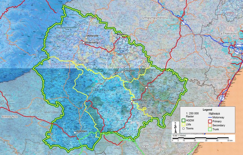
1.2 EMF Study Area
HGDM, formerly known as the Sisonke District Municipality (DM), is a Category C
Municipality situated in the south of KZN. The district covers an area of 10 547km². The
district borders with Umgungundlovu DM to the north-east, Alfred Nzo DM to the south and
south-west, Ugu DM to the south-east and Lesotho to the north-west. The district also
includes the southernmost part of the Maloti Drakensberg World Heritage Site (WHS). Refer
to Figures 2 and 3.
HGDM encompasses the following local municipalities:
Dr Nkosazana Dlamini Zuma Local Municipality (LM) (KZN436) –
This Municipality was established by the amalgamation of Ingwe LM and Kwasani LM.
The area of this LM is 3 602km2. It is the largest LM in the district, accounting for just over
a third of its geographical area. The Municipality fulfils the role of being the administrative
and commercial centre for the district. The rest of the municipal area consists of tribal
lands, which dominate the area. Towns in the Municipality include Creighton, Himeville
and Underberg.
uMzimkhulu LM (KZN435) –
The area of this LM is 2 435km2. It is the most populated of the municipalities.
uMzimkhulu Town (and adjoining Clydesdale peri-urban area) is regarded as the primary
node, both administrative and economic, in the municipal area. Rietvlei, Riversdale and
Ibisi are regarded as secondary nodes, fulfilling the role of rural service centres. Other
settlements such as Mountain Home, Glengarry, Ntsikeni and Ncambele (Gowan Lea)
can be regarded as minor service centres.
Greater Kokstad LM (KZN433) –
The area of this LM is 2 680km2. Kokstad serves as the service centre and commercial
hub for most of East Griqualand and nearby parts of the Eastern Cape, with which it
shares borders.
Ubuhlebezwe LM (KZN434) –
The area of this LM is 1 604km2. The main administrative centre of the Municipality is the
town of Ixopo, which is also the seat of the HGDM. The secondary and tertiary
development nodes include Highflats, Hlutankungu (previously Stuartsville), Jolivet,
KwaBhidla, Emgodi and Hlokozi.
November 2018 2Harry Gwala District Municipality EMF: Desired State Report (Draft)
Figure 2: HGDM National and Provincial Geographical Context
November 2018 3Harry Gwala District Municipality EMF: Desired State Report (Draft)
Dr Nkosazana Dlamini Zuma LM
Greater Kokstad LM
Ubuhlebezwe LM
uMzimkhulu LM
Figure 3: Locality Map
November 2018 4Harry Gwala District Municipality EMF: Desired State Report (Draft)
1.3 EMF Objectives
In order to address the triggers for sustainable development in the HGDM and the priority
environmental opportunities and constraints, the specific objectives of the EMF will include
the following:
1. To consolidate environmental information for the district;
2. To identify geographical areas in terms of Section 24 of the National Environmental
Management Act (NEMA) (Act No. 107 of 1998);
3. To consider the influence of the geographical areas to the listed activities under the
Environmental Impact Assessment Regulations (EIA) of 2014, as amended;
4. To develop a decision support system for development in the area to ensure that
environmental attributes, issues and priorities are taken into account;
5. To inform development planning in the district; and
6. To provide strategic guidance on environmental, economic and social issues in HGDM.
In its formal context, the EMF that is adopted by the Minister or MEC will be taken into
consideration when reviewing applications for environmental authorisation in or affecting the
areas to which the EMF applies. In addition, the EMF informs decision-making regarding
land use applications.
1.4 EMF Development Principles
In accordance with DEA (2010), the following principles have been applied in the
development of the HGDM EMF:
The EMF is customised to the context of Harry Gwala;
The EMF is undertaken with reference to environmental goals and priorities;
The EMF strives to encourage sustainable development;
The scope of the EMF is comprehensive enough to provide assistance to environmental
and planning decision-making in HGDM;
The EMF places specific focus on the issues and information that matter in decision-
making in HGDM;
Bio-physical, social, economic, and other aspects that are relevant in the District are
reflected in the EMF (based on the availability of information);
The EMF aims to be clear and easy to understand;
The process of developing the EMF included an appropriate level of public participation;
The process of developing the HGDM EMF was conducted impartially; and
The EMF takes into consideration the legal and policy requirements as well as guidelines
that are applicable to Harry Gwala.
November 2018 5Harry Gwala District Municipality EMF: Desired State Report (Draft)
1.5 EMF Development Approach
The EMF development approach is consistent with the requirements stipulated in the
following primary legislation that governs the process:
NEMA, in particular Sections 2, 23 and 24; and
The EMF Regulations (Government Notice No. R547 of 18 June 2010), which make
provision for the development, content and adoption of EMFs as a proactive
environmental management decision support tool.
In addition, the HGDM EMF will also conform to the Guideline on Environmental
Management Frameworks in terms of the EMF Regulations of 2010, Integrated
Environmental Management Guideline Series 6 (DEA, 2010).
An overview of the methodology to develop the EMF is broadly presented in Figure 4.
Figure 4: Broad overview of EMF Development Process
November 2018 6Harry Gwala District Municipality EMF: Desired State Report (Draft)
1.6 Establishing a Desired State
With the foundation of the EMF set through the Status Quo Phase,
the next step is to determine a realistic desired state for the
environment in HGDM.
Establishing the desired state includes setting a vision for
the District and providing the environmental management
context for the management zones and related
requirements for the various environmental features for the
SEMP. It also focuses on addressing the imperatives that lead
to the initiation of the EMF development process (refer to HGDM
EMF Volume 1: Status Quo Report), which include the following:
5. Significant environmental factors, for example –
According to the 2017-2022 HGDM IDP (HGDM, 2017), the district has high agro-
ecological potential due to an abundance of high quality soils, high altitude, and
abundant water. Commercial farms and to large extent commercial plantations form
the bedrock of the economy of the region. Climatic extremes make the area suitable
for a variety of products including crops and vegetables, livestock and sugar cane
around Ixopo/ Highflats area.
Extracts from the Biodiversity Sector Plan complied by Ezemvelo KZN Wildlife
(EKZNW) (EKZNW, 2014a) follow –
The district has two registered RAMSAR sites, namely the uKhahlamba
Drakensberg Park and Ntsikeni Vlei;
The district has several formally protected areas and other conservation areas;
The highly variable topography characteristic of the District creates biophysical
habitat and micro climatic conditions which support a range of biodiversity;
The District has three main catchments, namely the Mkomazi in the north, the
central Mzimkhulu and the Mzimvubu catchment in the south, as well as the
headwaters of the Mpambanyoni, Mtwalume and Mzumbe catchments located in
the north east;
The District has several large wetland systems including: the Pholela,
Ngwangwane and Ndawana systems in the north western section of the district in
the foothills of the Drakensberg; The Kromrivier and Mzintlanga systems in the
southern area of the district, which includes the Franklin Vlei; to the north the
Ntsikeni Nature Reserve and its extensive wetland system ; and to the north east
the Upper and little Bisi system; as well as several wetlands in remaining
municipalities;
The district contains terrestrial and aquatic Critical Biodiversity Areas (CBAs) and
Ecological Support Areas (ESAs);
The district contains five of the KZN Provincially derived terrestrial landscape
corridors, as well as local corridors;
November 2018 7Harry Gwala District Municipality EMF: Desired State Report (Draft)
Mzumbe River is one of the ten identified free flowing rivers in KZN. The top
section of the river falls within Harry Gwala, and is designated as an aquatic
landscape corridor in this District; and
Umzimkulu River, which originates in the Berg and flows through the centre of
Harry Gwala, is of the four National Flagship Rivers, and is designated as a
critical linkage in this district.
uKhahlamba Drakensberg Park WHS has been renamed since the inclusion of
Sehlabathebe National Park and now jointly the transfrontier WHS is referred to as
the Maloti Drakensberg WHS.
6. Development pressures and trends. The Harry Gwala District Growth and
Development Plan (DGDP) (HGDM, 2014) provide an indication of potential
development pressures and trends in the district, which include the following:
The District is sparsely populated (with some of the lowest population densities in the
Province), with a topography and human settlement pattern that can make it difficult
to service. However, the node and corridor system that is evident within the District
needs to be enhanced so that maximum value can be achieved through these. This
may mean, for example, encouraging appropriate development and density levels
within nodes, by prioritising the servicing of the nodes accordingly.
There are significant servicing backlogs within HGDM. If growth and development is
to occur within the District, then it is essential that the backlogs for all services (water,
sanitation, roads, housing, electricity and solid waste) are addressed.
Agro-processing is a significant driver for future economic growth in the district and
significant opportunities exist for expansion.
There is a strong emphasis on initiatives that especially support the agricultural and
tourism sectors in HGDM, which are regarded as existing local niches in the District.
7. Environmental Threats and Resource Management Issues, such as –
HGDM is primarily a rural district. Economic opportunities (viz. tourism and
agriculture) are directly linked to the environment. Water, climate, soil, biodiversity
and scenic beauty are especially relevant.
Land use in the district comprises primarily of agricultural, plantations, subsistence
farming, small areas of high density settlement and natural areas. The modification of
the natural environment occurs over the entire district but concentrated portions
occur in general in the north and north-eastern area of the district (EKZNW, 2014a).
Water as a key environmental resource needs to be more effectively harnessed, but
in a sustainable manner.
Agriculture benefits from good natural catchments, but tensions related to
contamination through fertiliser use, over extraction, and protection of wetlands need
to be balanced. Sanitation and water treatment challenges, as well as water
conservation strategies, are also issues that will affect development.
November 2018 8Harry Gwala District Municipality EMF: Desired State Report (Draft)
Mitigation and adaptation strategies in terms of climate change are necessary. This
affects both agriculture and tourism – the district’s key economic sectors.
Settlement patterns within the rural communities are characterised by widely
dispersed dwellings. This makes service provision very expensive.
With its mainly rural nature, most of HGDM’s inhabitants practice subsistence living
and are directly dependent on natural resources (food, craft production, subsistence
income, building material, fuel, medicinal purposes).
The HGDM Biodiversity Sector Plan (EKZNW, 2014a) notes the following land uses
and activities within the district which threaten CBAs and ESAs –
Unplanned and incompatible development (tourism and formal/informal
urban/rural);
Clearing of vegetation for informal settlement and associated subsistence
agriculture;
Expansion of forestry, sugarcane and other commercial cultivation;
Over utilization of natural resources/Eco services and medicinal species;
Poor land management activities;
Overgrazing and the unsustainable management of grazing land;
Destruction of wetland and riparian habitat.
Water pollution, resulting in algal blooms, fish kills loss of aquatic and riparian habitat
and increased costs for treatment of agricultural, industrial and potable water.
The approach to defining a desired state in HGDM is based on evaluating and integrating
the factors shown in Figure 5.
Figure 5: Factors influencing the ‘Desired State’
November 2018 9Harry Gwala District Municipality EMF: Desired State Report (Draft) The Management Priorities, which are strongly rooted in the outcomes of the Status Quo phase, express the desired state for HGDM. The remaining factors shown in Figure 5 contribute towards the spatial representation of the District’s desired state. These factors are expanded upon in the ensuing chapters. 1.7 Gaps, Assumptions and Limitations It is expected that the EMF and each of the Environmental Sensitivity Maps and Environmental Management Zones (EMZs) will undergo rigorous review and scrutiny by the relevant parties that will be involved with the application of the outcomes of the EMF, the implementation of its Management Guidelines or are potentially affected by the framework. Following the requisite amendments and incorporation of comments, this decision-making tool should be regarded as a concept EMF until the requirements of DEA and KZN EDTEA can be satisfied and the gazetting process has been completed. Environmental Sensitivity Maps and EMZs were demarcated using the best available information at the time when this report was compiled and the accompanying Geographical Information System (GIS) was developed. It is accepted that more accurate and supplementary information may become available subsequent to the finalisation of the EMF. A plan-do-check-act approach is thus advocated, where the framework will undergo a cycle of planning and implementation which needs to be followed by revisions and updating by its custodians. Ground-truthing is also crucial, especially for significant environmental attributes, which needs to feed into the evolving EMF. The following information gaps and limitations accompany the SEMP: The Environmental Sensitivity Maps and resultant EMZs were delineated and rated based on pre-determined (and available) criteria that were fed into a spatial model. Through further data refinement and the inclusion of new spatial information, the precision of the EMZs can be enhanced. Input from stakeholders could also lead to the re-adjustment of weightings, which could fine-tune the sensitivity rating system. Areas where conflict between development pressures and environmental sensitivity were identified were dealt with in the demarcation of the EMZs through a conservative and risk-averse approach. Nonetheless, opinions may vary as to the acceptable manner in which development pressures influenced the delineation of the EMZs. Despite efforts, limited information was sourced with regard to sector-related developments earmarked for the District, and the EMF may thus not holistically consider all the development pressures in HGDM. Further consultation is recommended with the Traditional Leaders to convey the implications of the framework for future development in the District in order to garner the necessary support in this regard. This should be facilitated through the KZN Department of Co-operative Governance and Traditional Affairs (COGTA). November 2018 10
Harry Gwala District Municipality EMF: Desired State Report (Draft) Through the Project Steering Committee and direct consultation, the project team endeavoured to obtain existing policies, strategies, plans and programmes, as well as information regarding earmarked developments that are relevant to HGDM. However, it is anticipated that not all of the spatial data and accompanying information was successfully sourced. These gaps may be identified during the review of the EMF. November 2018 11
Harry Gwala District Municipality EMF: Desired State Report (Draft) 2 DEVELOPMENT PRESSURES & TRENDS 2.1 Introduction Development is guided by various factors, including related policies and plans, population growth and distribution, income distribution, employment sectors, economic drivers, natural resource exploitation and growth sectors (amongst others). Development should strive to meet the societal needs while accommodating the receiving environment without compromising its goods and services. The EMF needs to take cognisance of future development pressures and trends in HGDM. Where possible, these developments should be accommodated as they contribute towards the much needed socio-economic enhancement of the District. Conversely, areas of potential conflict between earmarked developments and sensitive environmental features need to be identified to determine a sustainable way forward. In the sections to follow some of the key development pressures and trends in HGDM are examined further. 2.2 Provincial Planning 2.2.1 Provincial Growth and Development Strategy The Provincial Growth and Development Strategy (PGDS) (2016) established the development vision for KZN. The PGDS sets out the following seven strategic goals with specific strategic objectives being identified for each of these strategic goals (KZN Provincial Planning Commission, 2016): Inclusive economic growth; Human resource development; Human and community development; Infrastructure development; Environmental sustainability; Governance and policy; and Spatial equity. The Provincial Spatial Development Framework (PSDF) (shown in Figure 6) considered the following spatial elements: Environmental sensitivity and resilience; Priority social intervention areas; Priority areas of economic activity and potential; and November 2018 12
Harry Gwala District Municipality EMF: Desired State Report (Draft)
Levels of accessibility to public and private sector services.
Figure 6: KZN SDF 2016 (KZN Provincial Planning Commission, 2016)
In order to ensure the resulting PSDF guides and co-ordinates spatial planning within district
municipalities, it is envisaged that a series of sub-regional plans (e.g. Conservation and
Investment Corridors) will follow.
The Provincial Growth and Development Plan (PGDP) strives to translate the PGDS into an
implementation plan which will provide a sound platform for departmental, sectoral and
stakeholder annual performance planning and therefore to guide resource allocation.
2.2.2 Provincial Spatial Economic Development Strategy
The Provincial Spatial Economic Development Strategy (PSEDS) (2016) serves as the
framework to guide where the government’s economic initiatives should be implemented in
the Province.
November 2018 13Harry Gwala District Municipality EMF: Desired State Report (Draft)
Key spatial features in KZN include:
The Ingonyama Trust Board (ITB) owns just under 30% of the total land area in the
province. The ITB is a body corporate that owns the land in trust on behalf of the Zulu
Kingdom. All rural development plans on ITB land therefore require approval of the local
leadership;
Another key feature of the feature of the province is the national road network. The N2
runs along the coast linking all the main coastal cities which include harbour towns of
eThekwini and Richards Bay. The N3 links these coastal regions to the country’s
industrial heartland in Gauteng as well as the platinum belt in Rustenburg; and
The province is also characterised by many natural and man-made tourism features.
These include 600km of coast, the Midlands and Drakensburg mountains, historical
buildings and battlegrounds
The PSEDS recognises the following sectoral comparative advantages for HGDM (EDTEA,
2017):
The District is characterized by two high growth strategic nodes connected by high
growth strategic corridors. In the north, there is a potential tourism / commercial
agriculture corridor stretching from Kokstad to Underberg. At the center of the District is
a concentration of poverty nodes that are not on the main transport routes.
The district has natural advantages in -
Agriculture;
Forestry; and
Tourism;
The EDTEA is currently working on developing an Industrial Economic Hub in agro-
processing with the focus being on furniture manufacturing and dairy production;
Upgrading of the roads near Sani Pass and the Drakensberg will present eco-tourism
opportunities;
In terms of the poverty node at the center of the District, subsistence farmers should be
assisted where possible to transition to sustainable commercial farming; and
The proposed infrastructure builds should make use of the Extended Public Works
Programme.
Key spatial features that may affect economic development in HGDM include the following
(EDTEA, 2017):
This a largely rural District with a large residential population scattered throughout the
District;
The main transport routes within the District include a portion of the N2 that runs from
Port Shepstone to Mthatha in the Eastern Cape. In addition to this the R617 which runs
north from Kokstad to Underberg linking Msunduzi to Bulwer and also offers a lot of
tourism potential due to the relatively high volumes of traffic on the route. Sani Pass is
November 2018 14Harry Gwala District Municipality EMF: Desired State Report (Draft)
the only formal route into Lesotho from the province and provides tourists with the
opportunity to explore the Mountain Kingdom;
Some adventure tourism also takes place along the major river systems (canoeing on
the uMkhomazi and Umzimkhulu). The district has high eco-tourism and adventure
tourism potential;
There is notable commercial agriculture in the District with the notable exception being
uMzimkhulu. The Greater Kokstad area however has significant subsistence agriculture
potential and portions of the district form part of the Maloti Drakensberg Trans frontier
Project. This is a programme aimed at preserving unique and fragile ecosystems in
Lesotho and South Africa;
Formal conservation areas exist in Dr Nkosazana Dlamini Zuma LM that have special
ecological value and in terms of land use management must be protected in order to
maintain bio-diversity;
There is extensive commercial and subsistence farming in the District. The main
agriculture outputs are: livestock, maize, potatoes and deciduous fruit; and
A map of the South African Multidimensional Poverty Index (SAMPI) reveals that poverty
in the HGDM is largely concentrated in uMzimkhulu LM with four wards reflecting
significant relative deprivation. In Ubuhlebezwe LM, Ward 2 around the town of Ixopo
has the least deprivation whilst the areas around greater Kokstad and Franklin are
relatively better off.
Catalyst Projects linked to the PSEDS to drive growth and development to 2030 in HGDM
are listed in Table 1 and shown in Figure 7.
Table 1: Catalyst Projects for HGDM linked to PSEDS (EDTEA, 2017)
Node /
Project / Initiative Description Location Status
Corridor
1. Tourism Development
Sisonke Cultural Village Development of a cultural village uBuhlebezwe LM Planned -
and Heritage Precinct with world class accommodation
and conferencing facilities
Alan Paton Steam Train Expansion of the steam train Centred around Exploratory Ixopo
Tourism Route tourism route, including product Ixopo
development and marketing
Sani Pass Border Explore precinct development at Sani Pass Planned Corridor:
Development initiative Sani Pass for tourism purposes Howick -
Underberg -
Sani Pass
2. Exploiting agricultural potential
Clover Powder Milk The development of a Powder Milk Ingwe LM Exploratory Bulwer
Factory Factory by Clover (Bulwer)
Sisonke Hydroponic Production of high-value off uBuhlebezwe and Planned -
Farming Programme seasonal vegetables using uMzimkhulu LMs
hydroponic technology
Citrus Fruit Production Expand peach plantations to uMzimkhulu LM Planned -
80,000 trees
Essential Oils Project Development of a 10,000ha In all LMs Planned -
essential oils plantation
Sunflower Project Development of a 10,000ha In all LMs Planned -
November 2018 15Harry Gwala District Municipality EMF: Desired State Report (Draft)
Node /
Project / Initiative Description Location Status
Corridor
sunflower plantation
Maize Massification Development of 30,000ha of maize In all LMs Planned -
project plantations
Sisonke Farmers’ Market N/A N/A Planned -
Agri-hub Develop a network innovation Umzimkhulu/ Planned Umzimkhulu
system of agro-production, Ebutha farm
processing, logistics, marketing,
training and extension services.
3. Development of Agro-processing within the district
Animal Feeds Plant To establish an Animal Feeds District Wide Planned -
Manufacturing Factory using maize,
soya Bean and Essential Oils as
inputs
Essential Oils Development of a plant involved in uMzimkhulu Planned -
Manufacturing Plant the processing of essential oils and
its beneficiation into soap products
Saw Mills Revival Downstream beneficiation of wood District Wide Planned -
Programme and the manufacturing of wood
products
Maize Milling Plants Development of Maize Milling Makhoba Tribal Planned -
Plants and Silos Authority
Canning Plant N/A N/A Exploratory -
Bio-fuel Hub Development of bio-fuel extracting Ingwe LM Exploratory -
plant
Industrial/Agro- -
processing Economic
Hubs
4. Stimulating other manufacturing industries in the district
Purpose-built Industrial To develop and establish purpose- GSK; NMZ and Planned Ixopo
parks built industrial parks within the Ixopo
district
Clothing and Textiles Establishment of clothing and All LMs Planned -
Revival textile hubs in the district
5. Infrastructural Development
Rail Revival Revive the rail network in Sisonke District Wide Planned -
Regional airport Development of a regional airport Unspecified Envisioned -
for Sisonke
Bulwer Dam R2 billion development of dam in Bulwer Planned Bulwer
Bulwer
6. Priority District Rural Connecting Road
Integrated Municipal Upgrading uMzimkhulu Road -
Infrastructure Delivery, Infrastructure, uMzimkhulu LM
Strategic Infrastructure
New District Road/ (District road or similar) – Kokstad -
Transport route to Bulwer and uMzimkhulu to
Swartberg (and beyond)
Critical Road Upgrades P12 Himeville – Loteni and -
Nottingham Road to unlock tourism
from Gauteng, R56
Pietermaritzburg to Kokstad to
Eastern Cape upgrades to improve
accessibility and R612 Mzinto to
Bulwer to improve accessibility
7. Expansion of and Retail and Services sector
Kokstad Mall Development of a major mall at the Kokstad Envisioned Kokstad
N2 and R56 intersection
Ixopo Call Centre N/A Ixopo Planned Ixopo
8. Developments
Integrated Rural Isibizane/Makholweni IREDC 10 km along P8-3 Exploratory Corridor:
Economic Development (dense rural - high poverty - primary from Creighton Bulwer / Ixopo
Centres / secondary agricultural land - ITB turn onto D1345 - Kokstad /
November 2018 16Harry Gwala District Municipality EMF: Desired State Report (Draft)
Node /
Project / Initiative Description Location Status
Corridor
land) Underberg
Potential for agriculture
Figure 7: HGDM Nodes, Corridors and Projects (EDTEA, 2017)
2.2.3 KZN-N2 South Corridor
KZN COGTA has prepared a Strategic Corridor Plan for a defined area between Kingsburgh
(south of Durban) and Port Edward and between Port Shepstone and Kokstad, which is
referred to as the “KZN-N2 South Corridor” (see Figure 8). This corridor is informed by the
November 2018 17Harry Gwala District Municipality EMF: Desired State Report (Draft)
PGDS and associated SDF. The key objectives of the ‘KZN-N2 South Corridor’ Strategic
Corridor Development Plan are to:
Support value chain and logistics;
Encourage investment growth and development;
Coordinate infrastructure development; and
Guide land use and spatial planning.
Figure 8: KZN-N2 South Corridor (COGTA, 2017)
The consolidated Strategic Corridor Development Plan land use framework, corridors and
nodes with its associated “Protect”, “Change” and “New” Strategies should inform the
preparation of focus area plans. This will require a translation of the broader spatial concepts
to a smaller scale to facilitate and coordinate strategic interventions at a local level.
2.3 Local Planning
2.3.1 Harry Gwala District Growth and Development Plan
The Harry Gwala DGDP was prepared in 2014 as an extension of the KZN PGDP. The Plan
forms part of the Government package of plans consisting of the National Development Plan
(NDP), PGDP, DGDPs, Municipal IDPs and Ward Plans. The package of plans is focused on
November 2018 18Harry Gwala District Municipality EMF: Desired State Report (Draft) ensuring alignment between plans and thus improved growth and development throughout the country. The DGDP plan is a long term plan focusing on the year 2030. The municipal IDPs will align with the DGDP. The HGDM IDP (2012-2017 Term) states the vision of the District to be a leading water services provider in the KZN Province with its communities benefiting from a vibrant agriculture and tourism sector. However, in light of this noble vision, the District faces a few spatial challenges. Spatial challenges are issues that the country as a whole, not just Harry Gwala, faces. The NDP (2030) states that South Africa faces deficiencies with the local system of integrated development planning and the governance and administrative capability to undertake planning at all scales. The NDP goes further in elaborating that South Africa's intergovernmental system of spatial planning suffers from: Slow development; Poor coordination; Complex division of powers and functions between local, provincial and national government; and Ambiguities in the Constitution regarding responsibilities of spatial planning. On a more local level, the DGDP (2014) considers the District to be sparsely populated with some of the lowest population densities (increasing faintly along the access routes) in the Province, as well as a topography and human settlement pattern that can make it difficult to service. With that being said, Harry Gwala is a District with great potential, especially in the areas of agriculture and tourism, as illustrated in their IDP’s vision. 2.3.2 Development Corridors Corridors are established to provide a well-designed connectivity which attracts and improves accessibility in intense developments. The corridors suggested in the HGDM SDF are based on the recommendations in the PGDS, the various development informants identified in the earlier phase of the study and the goals and objectives of the HGDM SDF, with specific reference to the need to integrate district space and link the various nodes and opportunities into a meaningful whole; improve or extend access to areas with economic potential within areas of high poverty; maximise interest opportunities and potentials within the district in way which promotes growth and investment, and ensure the sustained growth of existing centres and corridors of economic development. Provincial Priority Corridors (SC2 and SC6) relevant to HGDM include: SC 2: Kokstad – Umzimkulu – Msunduzi (Secondary Corridor), and SC6: Port Shepstone – St Faiths – Ixopo (Secondary Corridor). November 2018 19
Harry Gwala District Municipality EMF: Desired State Report (Draft)
Notwithstanding the classification of these corridors as secondary in terms of the PGDS, it
must be emphasized that for the district these are the main focal corridors. The definition
and purpose of these corridors are described in the PSEDS as “a corridor serving areas of
high poverty levels with good economic development potential within one or two sectors.”
Although it could be argued that the primary function of these corridors is long distance
traffic movement, development should be encouraged at appropriate locations along the
corridors. More detailed planning at these locations will however be required as part of the
local SDF’s. The types of corridors in HGDM, based on the SDF, are listed in Table 2.
Table 2: HGDM corridor hierarchy based on SDF (draft 1)
Corridors Description and Location
Primary Corridors Kokstad- Matatiele-Lesotho (R56)
Kokstad-Underberg-Sani Pass-Lesotho (R617)
Underberg-Boston-Msunduzi (P7-4, P7-5, P7-2)
Underberg-Stepmore-Impendle-Nottingham Road (P27-2)
P68 has been identified as one of the primary corridors which links
Umzumbe and connects to Port Shepstone in the south and Highflats
in the north.
Secondary Corridors P604 from Swartberg to Matatiele
P252, 12 7-2 to Impendle
P602, P8-3 from Franklin to Creighton
P74-9 from uMzimkhulu to Ntsikeni
P601-2 from UMzimkhulu via Lourdes to Franklin
P750 From N2 to Franklin
Tertiary Corridors P113, P422, D634 P417, D609, D631
P929, P316, D2420 D636 ,D609, D959
P607, P320, D2412 D957, D625, P246
P125 ,P77 ,P8-2 D2411, D958, D612
D310 and P73 which continues through Umzumbe and runs through
Sipofu and Msisini to Turton
2.3.3 Nodal Development
According to the HGDM SDF for 2017/22, nodal planning seeks to enhance the provision of
adequate infrastructure, improves efficiency and provides a variety of land uses and public
transportation in the vicinity of communities. Nodal planning provides links between the
HGDM and other neighbouring areas through major transportation routes. Therefore, nodal
development should be encouraged because it improves efficiency by providing easy access
and thresholds for a variety of high quality services and uses.
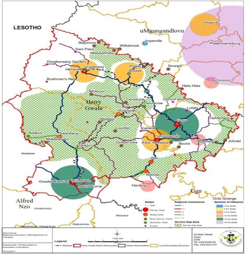
The HGDM SDF for 2017/22 (see Figure 9) provides a hierarchy of primary, secondary,
tertiary, rural service, and tourism/recreational nodes, which are summarised in Table 3.
When the hierarchy of nodes is proposed in the context of a District level, the classifications
November 2018 20Harry Gwala District Municipality EMF: Desired State Report (Draft)
of the same nodes at a national, provincial and even the local level may differ depending on
the scale at which they are being considered. The various nodes in this report can be
understood as areas where higher intensity of land use and social and business activities
occur.
Table 3: HGDM Nodal Hierarchy (HGDM, 2017)
Nodes Node Description Location and Rationale
Primary Nodes The sphere of influence for these primary nodes Urban centres of:
range from 10-15 km. These nodes serve the sub- Kokstad
regional economy of the district and are currently in
need of a detailed master-planning for infrastructural
Umzimkhulu
and services requirements for expansion. Services Ixopo
that are expected in these centres include agri Uderberg/Himeville
industrial development, large scale tourism projects, These areas have potential for significant
housing development, shopping centres, wide range economic development, growth and
of retail services, police services, primary, expansion. Their sphere of influence ranges
secondary and tertiary high level of education from 10-15km.
centres, hospitals, clinics, government departments,
satellite offices (especially for land affairs, social
welfare).
Secondary The typical services expected at these nodes Urban centres of:
Nodes include police stations, low level retail services and Franklin
housing development (less than 1000 lots), small
scale tourism, education facilities (primary and
Creighton
secondary), clinics, pension payout points, Donnybrook
community halls etc. Bulwer (treated as a primary node
due to potential posed by its
strategic location)
Highflats
These areas are said to comprise of sufficient
levels of economic development.
Tertiary Nodes These areas are said to have lower potential for Urban areas of:
providing economic services to local communities. Swartberg
Appropriate formalisation in terms of planning and
development control is required in these areas to
Riverside
enhance their development potential. Common Ibis
services that can be expected in these areas include Rietvlei
low level retail services, police stations, primary and These areas are described as having low
secondary education, clinics, pension payout points, levels for economic potential. The aim of
community halls, and taxi ranks. these tertiary nodes is primarily to serve local
communities.
Rural Service Rural service nodes represent the lowest order of In areas which comprise of minimal economic
Centres locality, where a range of service and economic potential such as:
activities could be concentrated in a sustainable Ntsikeni
way. These are the most accessible locations within
an acceptable distance of communities. The levels
Lourdes
of service found at these nodes are clinics, mobile GowanLea
services, post boxes shops, primary and secondary Centacow
school, pension payout point, taxi rank, and Kilmon
Traditional Authority Court. Ncwadi
Stepmore
Ntwasahlobo
Makhoba
Nokweja
Jolivet
Tourism and These nodes are situated in areas that are attractive These nodes are located on private land
Recreation and have the potential for resource orientated such as:
Nodes activities. The areas have easy access to the In Kokstad on the N2
wilderness/ natural areas through controlled points.
Ntsekeni Nature Reserve
Ophepheni
November 2018 21Harry Gwala District Municipality EMF: Desired State Report (Draft)
Nodes Node Description Location and Rationale
Indlovu Clan (Ubuhlebezwe to west
R46) Qunu falls
Figure 9: HGDM SDF (HGDM, 2017)
November 2018 22Harry Gwala District Municipality EMF: Desired State Report (Draft)
3 DEVELOPMENT OPPORTUNITIES & CONSTRAINTS
3.1 Introduction
The potential for development in HGDM is linked to the available opportunities present as
well as strengths of various environmental features and economic sectors. Conversely, the
constraints and weaknesses associated with the District need to be overcome to ensure that
it’s the full development potential can be harnessed.
According to the 2017-2022 HGDM IDP (HGDM, 2017), the key economic opportunities in
the largely rural District include agriculture and tourism. These are elaborated on in the
sections to follow. The manner in which the EMF provides support to the desired state
objectives for these features is also shown.
3.2 Agriculture
Agriculture is a critical sector within the District’s economy. It is the second largest in Gross
Value Added (GVA) terms and has the potential to continue to contribute to the growth and
development of HGDM. The most important commercial enterprises in HGDM include:
Dairy - supplies 10% of all milk consumed in South Africa, and 35% of Clover’s total milk
intake;
Cash crops such as maize and potatoes, and
Beef Farming.
There are also commercial forestry plantations that provide raw materials for wood-related
products.
Opportunities and constraints associated with Agriculture in HGDM, as well as the
implications for the EMF, are presented in Table 4.
Table 4: Opportunities and Constraints associated with Agriculture in HGDM
Opportunities Constraints EMF Support
Agro-processing is a significant Socio-economic factors which are The desired state that was
driver for future economic growth in posing risks to the local agricultural established by the EMF is
the District, with significant industry include crime and as follows: maintain
opportunities for expansion in: uncertainties associated with land existing agricultural
Land suitable for high value reform productivity and reserve
crops; Although the Agricultural sector areas with high agricultural
provides employment potential for future related
Land reform programmes
opportunities, especially in Ixopo; uses, thereby promoting
supported by significant public food security in HGDM.
lack of housing opportunities
sector investment and
provides constraints with regards In support of the desired
parastatal bank loans;
to productivity as employees travel state, high value
Access to export markets; far to access workplace. agricultural land and areas
Support institutions for funding Roads within the Municipality are in where agriculture is the
and technical advice e.g. poor condition. This also hinders primary land use will be
November 2018 23Harry Gwala District Municipality EMF: Desired State Report (Draft)
Opportunities Constraints EMF Support
Masisizane Fund; flexible transportation of people included in the Agriculture
New production techniques, and trade of goods. Environmental
e.g. hydroponics; There is lack of capital for Management Zone (EMZ),
emerging farmers. with accompanying
Processing, packaging and
distribution of local produce – No-go areas for agriculture, such Management Guidelines.
as protected areas and The EMF can be used to
canning, drying, freezing and
watercourses. identify suitable and
further product beneficiation;
and Water abstraction rights need to be compatible areas that
formalised in order to quantify the support agricultural
Forestry, milling and demand. activities (e.g. agri-parks).
production of related product It will also show areas
(Biofuel, charcoal etc.).
Climate change effects, such as
unpredictable weather patterns and where the receiving
The Agricultural industry is more extreme climate events. environment is deemed to
labour intensive and is located be sensitive and where
strategically along the R612 and
Threatened agricultural land
certain developments
(category B) is dominant in the
R56. (such as agriculture) are
District, particularly in the Greater
A fairly developed institutional Kokstad and Dr Nkosazana
not supported, and which
arrangement has been created for need to undergo more
Dlamini Zuma LM’s.
emerging farmers to provide rigorous environmental
support in terms of education
Soil degradation caused by assessments to show that
unsustainable agricultural practices the desired state will not
though public and private
(such as over utilization of soils). be compromised. Such
enterprises.
The district has some areas with
Lack of knowledge and skills. assessments may also
naturally fertile soil and soils of Soil contamination and shallow serve as ground-truthing
favourable structure soils. and find the environment
Climate conditions allow for a wide Steep slopes reduce agricultural to be more suitable to the
potential in several ways: difficulty development.
range of agricultural opportunities.
in land cultivation, reduced rainfall
The north eastern portion in the
per area unit, shallow soil profile,
Ubuhlebezwe LM has substantial
reduced water retaining capability
patches of higher grazing capacity.
and reduced accessibility and
Forestry features prominently in isolation from markets and
the District. services.
The district hosts both successful Potential risks posed by climate
commercial farmers as well as change are likely to place pressure
emerging farmers. on the agricultural potential of the
Alternative livelihood options such District.
as beekeeping, permaculture, fire Removal of riparian vegetation and
wood, charcoaling, etc. wetlands to make way for
Opportunities to invest in better subsistence farming.
agricultural education and land Capacity to identify requirements
care programmes. and obligations in terms of NEMA,
Establishment of agri-parks. National Water Act (Act No. 36 of
Business Plan compiled for HGDM. 1998) (NWA) and Conservation of
Agricultural Resources Act (Act No.
43 of 1983) (CARA).
3.3 Tourism
According to the DGDP (HGDM, 2014), the potential within the District for tourism is large
and can have significant economic benefits. There is a strong emphasis in the DGDP on
initiatives that support the tourism sectors in HGDM. According to the PSEDS the District
has a high growth strategic node connected by high growth strategic corridors, with a
potential tourism stretching from Kokstad to Underberg.
Some of the current tourism opportunities in HGDM include:
Maloti Drakensberg WHS;
November 2018 24You can also read