Development Corridors in Kenya - A Scoping Study - Development Corridors Partnership
←
→
Page content transcription
If your browser does not render page correctly, please read the page content below
Development Corridors
      in Kenya
                 A Scoping Study

  Source: Ministry of Transport and Infrastructure GoK 2014
The Development Corridors Partnership is a research and capacity building
collaboration among institutions from China, Kenya, Tanzania, and the UK. Its main
purpose is to deliver effective research and build capacity so development corridor decision-
making can be based on sound scientific evidence and effective use of available planning
tools and procedures.

Partners

Funders

How to cite this report:
DCP Kenya (2019). Development Corridors in Kenya - A Scoping Study. A Country Report
of the Development Corridors Partnership (DCP). Contributing authors: Daniel Olago, Lucy
Waruingi, Tobias Nyumba, Catherine Sang, Yvonne Githiora, Mary Mwangi, George Owira,
Francis Kago, Sherlyne Omangi, Jacob Olonde and Rosemary Barasa. Institute for Climate
Change and Adaptation (ICCA) the University of Nairobi and African Conservation Centre
(ACC), Nairobi, Kenya. e-Published by UNEP-WCMC, Cambridge, UK
Executive Summary
This report presents the results of the study ‘‘Development Corridors in Kenya: A Scoping Study”.
The objective was to review the current baseline situation in relation to mega-scale development
corridor projects in Kenya with regard to the people and society, environment, conservation and
development. The work forms the basis for the planning and implementation of the Development
Corridors Partnership (DCP) research programme that will offer innovative solutions towards
achieving these mentioned goals both in Kenya and Tanzania but also aims to showcase best
practice applicable to other countries and regions.
The scope of the report includes a conceptual framework for understanding development
corridors in Kenya and related initiatives as outlined in the National Spatial Plan 2015-2045, with
the Lamu Port and Lamu-Southern Sudan-Ethiopia Transport (LAPSSET) and Standard Gauge
Railway (SGR) corridors being the two main corridors under consideration. It then reviews a
broad array of stakeholders and their influence on Kenya’s development corridors. It analyses the
development corridor implementation in Kenya by looking into Corridor Project Negotiation and
Agreement Process, challenges to corridor implementation, litigation and resultant impacts. It
goes further to highlight potential social and ecological impacts of development corridors, and
climate change-related risks facing the development corridors.
The study applied several data collection and analysis tools. Literature review, stakeholder
analysis and a critical review of relevant policies and legislation were completed to identify actors
and policy, as well as legislative frameworks relevant to the development corridors in Kenya.
Efforts were also made to collect data from selected government agencies and actors through
telephone and email communications (Section 1.1 to 1.3).

Key Findings
   1. Development corridors in Kenya and related initiatives (Section 2.1 & 2.2)

This study established that Kenya has two main development corridor projects. The first one is
the Lamu Port-Southern Sudan-Ethiopia Transport (LAPSSET), a flagship project under Kenya’s
Vision 2030, whose aim is to create seamless connectivity between the East African countries of
Kenya, Ethiopia and South Sudan. The second is the Standard Gauge Railway (SGR), which is
also a Vision 2030 flagship project as well as the East Africa Railways Master Plan (2009) project
aimed at connecting Kenya, Tanzania and Uganda. Additionally, other development corridor
related initiatives identified include dams and water transfers, Lake Turkana Wind Power Farm,
oil and gas exploration and production, airports, resort cities and industrial park projects.
   2. Key Stakeholders and their influence in Kenya’s Development Corridors (Section 3.1
       to 3.7)

Over 100 stakeholders involved in the design, development and implementation of development
corridors in Kenya were identified and documented. These include government ministries,
parastatals and research institutions, industries, regional bodies, international/donor agencies,
Non-Governmental Organizations (NGOs), and umbrella bodies (such as Kenya Private Sector
Alliance (KEPSA) and Kenya Association of Manufacturers (KAM)). All these stakeholders have
continued to influence policies towards development corridors in Kenya at varying levels as
discussed in Section 3. The Office of the President (OP) features prominently as the key initiator
and decision maker in the development corridor processes in Kenya. However, the government
through its relevant ministries play a central role in providing strategic direction and support for
the implementation of the projects.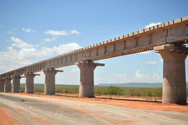
3. Development corridor implementation in Kenya (Section 4.1 to 4.3)

The conceptual framework for the development corridors in Kenya is outlined in the National
Spatial Plan 2015-2045. The study found that the process of initiation and implementation of
development corridors in Kenya is guided by the Public Private Partnership Act No 15 of 2013.
Moreover, the project execution process begins with the relevant government authority inviting
proposals from potential project investors and contractors to show their interest and eligibility,
and follows through eighteen stages. The conducive regulatory framework in the utility sectors
facilitates Public-Private Partnerships (PPPs), supportive policy and legal environment, with
several sectoral legal strategies and policy process.
   4. Challenges to corridor implementation (Section 4.4)

The study established that there are several challenges faced during development corridors
implementation in Kenya. These include: litigation and its resultant impacts, change to a
devolved system of government, national and regional politics, management challenges due to
human resource management issues, corruption and fraud during land acquisition and
compensation, delay in passing of legislation, financial constraints resulting to delayed
construction, insecurity due to presence of the Al-Shabaab, and climate change-related risks.
These challenges have resulted mainly in the delay in the implementation of the corridor projects,
lack of support by the local communities, loss of revenue and investor confidence, and conflict
between different stakeholders.
   5. Potential impacts of development corridors (Section 5.1, 5.2, 6.1, 6.2 & 6.3)

The study identified several potential impacts associated with the development corridors in
Kenya. These include land and water scarcity, biodiversity loss, social marginalisation, economic
displacement, resource-based conflicts, deforestation, threats to heritage sites, livelihood impacts
and dilution of cultural identity, increased exposure to drugs and diseases (including HIV/AIDS
expansion), and child labour and climate change related impacts. Although Kenya has put in
place a comprehensive climate change strategy and climate change institutional structures, it
was found that there is little evidence of the integration of climate risks into plans for Kenya’s
development corridor processes to foresee and mitigate climate change impacts. Apart from the
negative impacts, the results of the study also showed that there are several potential positive
impacts which include: opening of remote areas, economic growth and development of the area,
more efficient modes of transport, improved security, reduced accidents in the highways, rapid
growth of urban centres, and perhaps intensified agricultural activities.
   6. Kenya’s ESIA and SEA process (Section 7.1 &7.2)

The Environmental and Social Impact Assessment (ESIA) and Strategic Environmental
Assessment (SEA) are anchored on the National Environment Management and Coordination
Act of 1999 and revised in 2015 to both align it with the Constitution of Kenya 2010 and to
incorporate some aspects such as Strategic Environmental Assessments. These processes are
governed by the National Environment Management Authority (NEMA). As a party to
international conventions, treaties and agreements on the management of the environment,
Kenya through NEMA initiate legislative proposals to give effect to them. The objective of the
SEA in Kenya is to systematically integrate environmental considerations into policy, planning
and decision-making processes, such that environmental information derived from the
examination of proposed policies, plans, programmes or projects are used to support decision
making. This study established that the ESIA and SEA processes and results underestimated the
actual impacts of the SGR and LAPSSET projects on nature and people, while the mitigation
measures, their implementation, monitoring and evaluation were inadequate or non-existent.

                                                                                                     2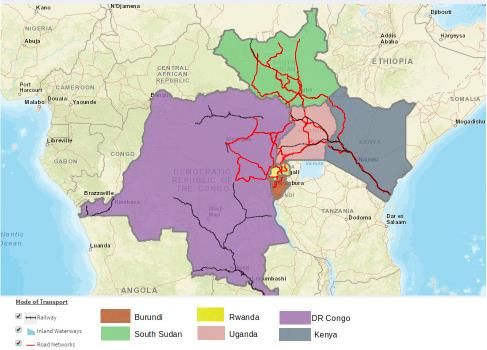
7. Priority research areas and capacity needs in Kenya (Section 8.1 & 8.2)

Based on the findings of the scoping study, several priority research areas are proposed with
themes that are centred on corridor impacts, mitigation and sustainable management. These are
biodiversity and conservation, water resources and supply-demand assessments, livelihoods,
climate change adaptation in corridors, and scenarios of land use in the corridors. The study
identified some capacity needs and are as follows: training for professionals in carrying out EIAs
and SEAs, training for regulators in ESIAs and SEAs, training of Post-Doctoral Research
Assistants and Research Assistants on quantitative and qualitative research methods,
stakeholder engagement skills, land use scenarios analysis, image processing and GIS,
modelling, climate change and adaptation skills, and scientific writing skills.

                                                                                                 3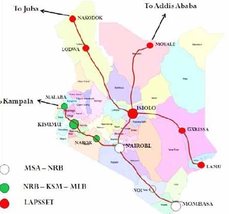
Contents
Executive Summary ..................................................................................................................... 1
    Key Findings............................................................................................................................. 1
Contents ...................................................................................................................................... 1
Figures ......................................................................................................................................... 3
List of Abbreviations ..................................................................................................................... 1
1      Introduction ........................................................................................................................... 2
2      Methodological approach to the scoping study ...................................................................... 3
    2.1      Literature review ............................................................................................................ 3
    2.2      Stakeholder analysis ...................................................................................................... 3
    2.3      Observations and interviews .......................................................................................... 3
3      Development corridors in Kenya and related initiatives ......................................................... 3
    3.1      LAPSSET corridor.......................................................................................................... 5
       3.1.1        How it came about, where and what it is ................................................................. 5
       3.1.2        LAPSSET past and current stretch ......................................................................... 6
       3.1.3        LAPSSET key decision makers .............................................................................. 6
    3.2      SGR corridor .................................................................................................................. 6
       3.2.1        How it came about, where and what it is ................................................................. 6
       3.2.2        SGR past and current stretch .................................................................................. 7
       3.2.3        SGR key decision makers ....................................................................................... 7
    3.3      Related initiatives ........................................................................................................... 8
       3.3.1        Dams and water transfers ....................................................................................... 8
       3.3.2        Lake Turkana Wind Power Farm............................................................................. 8
       3.3.3        Oil and gas exploration and production ................................................................... 8
4      Stakeholders and their influence in Kenya’s development corridors ...................................... 9
    4.1      Government Ministries and county governments ........................................................... 9
    4.2      Parastatals and research institutions ........................................................................... 11
    4.3      Industries ..................................................................................................................... 12
    4.4      Regional bodies ........................................................................................................... 13
    4.5      Donor agencies and international NGOs ...................................................................... 13
    4.6      National Non-Governmental Organisations (NGOs) ..................................................... 15
    4.7      Umbrella bodies ........................................................................................................... 16
5      Development corridor implementation in Kenya .................................................................. 16
    5.1      Regulatory anchors ...................................................................................................... 16
    5.2      Corridor project negotiation and agreement process .................................................... 17
    5.3      Procedures for the execution of projects ...................................................................... 18
    5.4      Challenges to corridor implementation ......................................................................... 20
5.4.1        Litigation and its resultant impacts ........................................................................ 20
       5.4.2        Devolution, national and regional politics .............................................................. 21
       5.4.3        Management challenges ....................................................................................... 21
       5.4.4        Corruption and fraud during land acquisition and compensation ........................... 21
       5.4.5        Delay in the passing of legislation ......................................................................... 21
       5.4.6        Financial constraints resulting in delayed construction .......................................... 22
       5.4.7        Insecurity due to the presence of the Al-Shabaab ................................................. 22
6      Potential impacts of development corridors ......................................................................... 22
    6.1       Biophysical impacts of development corridors.............................................................. 22
       6.1.1        Land and water ..................................................................................................... 22
       6.1.2        Biodiversity ........................................................................................................... 23
    6.2       Socio-economic impacts of development corridors ...................................................... 23
       6.2.1        Displacement of people, conflicts and land speculation ........................................ 23
       6.2.2        Social marginalisation and cultural value deterioration .......................................... 23
       6.2.3        Livelihoods and poverty reduction ......................................................................... 24
7      Climate Change-related risks facing the development corridors .......................................... 24
    7.1       Climate change key trends........................................................................................... 24
    7.2       Impacts on development corridors from climate change .............................................. 25
    7.3       Climate change adaptation and mitigation ................................................................... 25
8      Kenya’s ESIA and SEA process.......................................................................................... 26
    8.1       Regulatory framework .................................................................................................. 26
    8.2   The Environmental Impact Assessment (EIA) and Strategic Environmental Assessment
    (SEA) processes .................................................................................................................... 26
9      Priority research areas and capacity needs in Kenya .......................................................... 28
    9.1       Priority research areas ................................................................................................. 28
    9.2       Capacity needs ............................................................................................................ 29
10         Conclusions ..................................................................................................................... 30
11         Bibliography .................................................................................................................... 31
12         Appendices ..................................................................................................................... 35
    12.1      Appendix 1. Quality of the coverage of the sectors in the adaptation literature............. 35
    12.2      Appendix 2. List of Key Stakeholders in the Development Corridors in Kenya ............. 36
    12.3      Appendix 3. List of Development Corridor and related projects .................................... 38
    12.4 Appendix 4. Policy and Legislative Frameworks relevant to the Development Corridor
    Processes .............................................................................................................................. 42
    12.5 Appendix 5. The likely impacts of development corridors on biodiversity and areas of
    conservation importance ........................................................................................................ 47
       12.5.1       References ........................................................................................................... 49
    12.6      Appendix 6. Key challenges to corridor implementation in Kenya by Corridor projects. 50

                                                                                                                                             2
Figures
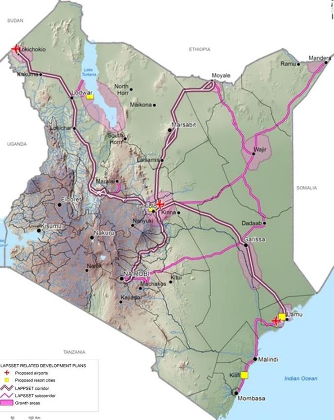
Figure 1: The northern corridor member states and envisaged transit and transport links. ............. 4
Figure 2: Position of the SGR (Phases I & II) (a) in relation to the LAPSSET and (b) location of the
LAPSSET Corridor including roads, proposed resort cities and proposed airports ........................... 5
Figure 3: Power vs influence diagram for government ministries in corridor development processes.
...................................................................................................................................................................... 10
Figure 4: Power vs influence diagram for parastatals and research institutions .............................. 11
Figure 5: Power vs influence diagram for industries ............................................................................. 12
Figure 6: Power vs influence diagram for donor agencies and international NGOs ........................ 14
Figure 7: Power vs influence diagram for NGOs ................................................................................... 15
Figure 8: Power vs influence diagram for umbrella bodies .................................................................. 16
Figure 9: Steps in Establishing Public-Private Partnerships ............................................................... 18
Figure 10: Steps to be followed in Development Corridors Projects Identification and Selection . 18
Figure 11: Steps followed in actualizing solicited proposals ............................................................... 19
Figure 12: Steps followed when acquiring land for development corridors ....................................... 20
Figure 13: Integrated EIA development process in Kenya. Note: PPP – Policies, Plans and
Programmes................................................................................................................................................ 27
Figure 14: SEA development process in Kenya .................................................................................... 28
3List of Abbreviations AfDB- African Development Bank ASALs- Arid and Semi-Arid Lands AU- African Union COMESA- Common Market for Eastern and Southern Africa CRBC- China Road and Bridge Corporation CRDC- China Railway Design Corporation CSOs- Civil Society Organizations DCP- Development Corridors Partnership EAC- East African Community EIA- Environmental Impact Assessments ERS- Economic Recovery Strategy for Wealth and Employment Creation ESIAs- Environmental and Social Impact Assessments EU- European Union FoNNAP- Friends of Nairobi National Park GDP- Gross Domestic Product GIS- Geographic Information System GoK- Government of Kenya HIV/AIDS- Human Immunodeficiency Virus/ Acquired Immunodeficiency Syndrome IGAD- Intergovernmental Authority on Development INGOs- International Non-Governmental Organizations JICA- Japan International Corporation Agency KALRO- Kenya Agricultural and Livestock Research Organization KAM- Kenya Association of Manufacturers KEPSA- Kenya Private Sector Alliance KRB- Kenya Roads Board KWCA- Kenya Wildlife Conservancies Associations LAPSSET- Lamu Port-Southern Sudan-Ethiopia Transport LCDA- LAPSSET Development Corridor Authority MoICNG- Ministry of Interior and Coordination of National Government MoNTP- National Treasury and Ministry of Planning NCTTA- Northern Corridor Transit and Transport Agreement NEMA- National Environment Management Authority NGO- Non-Governmental Organizations NLC- National Land Commission NNP- Nairobi National Park PIDA- Programme for Infrastructural Development in Africa PPP- Public Private Partnership Act UNDP- United Nations Development Programme RAs- Research Assistants SADC- Southern African Development Community SDGs- Sustainable Development Goals SEAs- Strategic Environmental Assessments SGR- Standard Gauge Railway STE- Save The Elephants USAID- United States Agency for International Development VDS- Vision 2030 Delivery Secretariat WB- World Bank
1 Introduction
The Kenya Vision 2030 is Kenya’s long-term development blueprint that “aims to transform
Kenya into a newly industrializing, middle-income country providing a high quality of life to all its
citizens by 2030 in a clean and secure environment” (GoK-NESC 2007). The Kenya Vision 2030
was launched on October 30, 2006 and is based on three ‘pillars’: the economic, the social and
the political. The adoption of the Vision follows the successful implementation of the Economic
Recovery Strategy for Wealth and Employment Creation (ERS) launched in 2002 (GoK 2003).
The Vision is being implemented in successive five-year medium-term plans, with the current
third plan covering the period 2018-2022. The economic, social and political pillars of the Kenya
Vision 2030 are anchored on macroeconomic stability, continuity in government reforms,
enhanced equity and wealth-creation opportunities for the poor, infrastructure, energy, science,
technology and innovation, land reform, human resources development, security, and public
sector reforms. Being a top priority government plan and with mandates cutting across multiple
ministries, it is nested in the Office of the President (GoK-NESC 2007).
The Vision has identified several flagship projects in every sector to be implemented over the
Vision period and to facilitate the desired growth rate. In the Vision 2030 Sessional Paper No. 12
of 2012, one of the goals/strategies is to build infrastructure development to support identified
flagship projects, to ensure contribution to the economic growth and social equity goals. It also
calls for the strengthening of the institutional framework for infrastructure development and
accelerating the speed of completion. This development must be assessed against the backdrop
of “Isolation, insecurity, weak economic integration, limited political leverage, and a challenging
natural environment that combine to produce high levels of risk and vulnerability”, as noted in the
Vision 2030 Development Strategy for Northern Kenya and Other Arid Lands (GoK 2012).
More recently, Kenya launched the Big Four Agenda and Action Plan to guide the development
agenda of the country in the period 2018-2022. The Agenda is closely aligned to the Vision 2030
and is focused on following topical issues: manufacturing, affordable housing, universal health
care and food security. Manufacturing has the potential to advance socio-economic development
through increased and diversified exports, reduced import bills and enhanced employment
creation (KIPPRA 2018). But it, along with housing and food security, are associated with
buildings and associated structures that occupy land spaces and host activities that impact on
the environment. Likewise, a clean environment and universal access to safe water can greatly
improve public health and minimise costs related to health care services. In this manner, well
designed Environmental Impact Assessments and Strategic Environmental Assessments for
development corridors and auxiliary infrastructure can play a critical role in meeting the goals of
the Big Four Agenda.
Corridor developments, which comprise the installation of linear or polygonal megastructures,
have direct and indirect impacts on the four “spheres” of planet earth: the biosphere,
hydrosphere, atmosphere and lithosphere. As well as impacting on people and their diverse
societal structures and interactions, including socio-ecological interdependencies, within their
known, predicted, and unknown spheres of influence. Given these actual and potential effects, it
is important to ensure that corridor developments are undertaken ensuring that a balance is
maintained between conservation and development, and that generational and inter-generational
benefits are at least sustained, or better still accrue with time. This Scoping Report reviews the
current baseline situation in relation to mega-scale corridor development in Kenya with regard to
society, environment, conservation, and development. This report forms the basis for the
planning and implementation of the Corridors Development Partnership (DCP) research
programme that will offer innovative solutions towards achieving these mentioned goals, both in
Kenya and globally.

                                                                                                    2
2 Methodological approach to the scoping study
2.1 Literature review
The DCP Kenya team conducted a detailed review of relevant open access published papers;
government documents, policy papers, reports and strategies; private sector reports, documents
and strategies; and media reports and commentaries related to development corridors. In
particular, the team reviewed documents relating to the planning process, implementation and
impacts of the installation of the Standard Gauge Railway (SGR) and the Lamu Port South
Sudan Ethiopia Transport (LAPSSET) corridor and their related initiatives in Kenya.
2.2 Stakeholder analysis
The stakeholder analysis was conducted systematically based on Mitchell’s taxonomy of
stakeholders (Mitchell et al. 1997). Stakeholders were identified and mapped based on their
interaction either with the SGR and LAPSSET directly, or with the communities living in the
corridor areas. Power-influence mapping was undertaken based on the perceived authority of the
stakeholder in the corridor area. For example, government parastatals and ministries with
representatives on the LAPSSET Corridor Development Authority Board would be considered to
have high power and influence.
2.3 Observations and interviews
The foundation laid by the literature review and the stakeholder analysis made it possible for the
research team to carry out visits to the field, where primary data was collected. Formal and
informal interviews with corridor institutions such as LAPSSET, Konza Technopolis Development
Authority (KOTDA), Kenya National Highways Authority (KeNHA), Geothermal Development
Company ( GDC) and SGR were conducted as were opportunistic interviews with individuals
interested in development corridors in Kenya. This included groups such as Kenya Wildlife
Conservancies Association (KWCA), Save the Elephants (STE), Amara Conservation, Friends of
Nairobi National Park (FoNNAP) and other stakeholders.
3 Development corridors in Kenya and related initiatives
In 1985, the countries of Burundi, Democratic Republic of Congo, Kenya, Rwanda, and Uganda
signed the Northern Corridor Transit and Transport Agreement (NCTTA) and its associated
protocols to implement the Northern Corridor. The Northern Corridor is a multimodal trade route
linking the landlocked countries of the Great Lakes Region with the Kenyan maritime seaport of
Mombasa1. South Sudan acceded to the Agreement in 2012. The Northern Corridor was
envisaged to facilitate regional economic development. Implementation of the Agreement was
vested in the Northern Corridor Transit and Transport Coordination Authority which is based in
Mombasa, Kenya. This is partly the context within which the national development corridors have
been framed (Figure 1).
1
http://www.ttcanc.org/page.php?id=11
3Figure 1: The northern corridor member states and envisaged transit and transport links.
Source: Northern Corridor Transit and Transport Coordination Authority website2
The conceptual framework for the development corridors in Kenya is outlined in the National
Spatial Plan 2015-2045, with the LAPSSET and SGR corridors being the two of focus (GoK
2015). Development corridors in Kenya are diverse, ranging from linear infrastructure such as
rails, roads and pipelines, to spatially spread nodes such as business hubs, ports and luxury
cities (Figure 2). Today, several projects have been proposed and are either ongoing or planned.
Four projects have featured prominently. These are 1) The LAPSSET Corridor; 2) SGR Corridor;
3) KOTDA, and 4) the Resort Cities. Other associated projects include the expansion of existing
highways in the country, installation of wind power projects in Northern Kenya and the
construction of dams to aid water transfer in the country. These projects are outlined briefly
below, and more details are presented in the Appendices.
2
http://www.ttcanc.org/
4a) b)
Figure 2: Position of the SGR (Phases I & II) (a) in relation to the LAPSSET and (b) location of the
LAPSSET Corridor including roads, proposed resort cities and proposed airports
Source: Kenya Railways 2013, Letai and Tiampati 2013
3.1 LAPSSET corridor
3.1.1 How it came about, where and what it is
The Lamu Port-Southern Sudan-Ethiopia Transport (LAPSSET) corridor was initiated under
Kenya’s Vision 2030. The project aims to create seamless connectivity between the Eastern
African Countries of Kenya, Ethiopia and South Sudan, connecting an estimated population of
160 million people across these three countries. Further, the corridor is part of the larger land
bridge intended to connect the East African coast from Lamu Port to the west coast of Africa at
Douala Port, Cameroon. Regional economic bodies such as COMESA-EAC-SADC Tripartite and
the Intergovernmental Authority on Drought and Development (IGAD) are involved in the
extension efforts (Lapsset Corridor Development Authority 2016).
LAPSSET comprises Lamu Port, a railway line, road network, oil pipeline, oil refinery, airports
(e.g. at Isiolo, Lamu), and resort cities (e.g. Isiolo). Some of these elements are in progress. For
instance, the Lamu Port construction was launched on 2nd March 2012 and is still ongoing,
whereas an airport in Isiolo is already complete although is not yet operational. The road that
links Isiolo with Moyale on the Ethiopian border was 85% complete by 2016 (Lapsset Corridor
Development Authority 2016).
During the African Union (AU) Summit held in Johannesburg, South Africa in June 2015,
LAPSSET was endorsed and added to the AU Presidential Infrastructure Championship Initiative
(PICI) project. Further, the project’s admission to the African Union PIDA project (Programme for
Infrastructure Development in Africa) elevated its financial support from continental institutions
5such as AU/NEPAD (New Partnership for Africa’s Development) (Lapsset Corridor Development
Authority 2016).
3.1.2 LAPSSET past and current stretch
The only extensive infrastructure prior to the implementation of the LAPSSET corridor project
was the road network, but it was poorly to moderately developed, comprising mainly of marram.
The envisioned corridor, when complete, will have a length of over 2,000km, from the coastal
town of Lamu and extending into the hinterland, to the Sudan border through the Isiolo, Lodwar
and Nakodok, and with a branch from Isiolo extending northwards to the Ethiopia border via
Moyale. It traverses the following counties: Lamu, Garissa, Isiolo, Meru, Laikipia, Samburu,
Baringo, Marsabit and Turkana (Figure 2). Further, LAPSSET will consist a 1,710km long railway
line, a 2,240km long oil pipeline, and a dual carriageway of 880km (REPCON Associates 2017).
3.1.3 LAPSSET key decision makers
There are multi-level, and multi-sectoral stakeholders involved with key decision making process
at various stages of the LAPSSET project. They included: The Office of the President (OP) which
initiated and is leading the process, as well as government ministries, parastatals, umbrella
bodies, regional and international agencies, and Non-Governmental Organisations (NGOs),
among others. In March 2013, through the Presidential Order Kenya Gazette Supplement No. 51,
Legal Notice No. 58, the LAPSSET Corridor Development Authority (LCDA) was established.
The agency is charged with steering the LAPSSET corridor project working in conjunction with
the Office of the President and key stakeholder ministries as key decision makers. The ministries
that sit on the LCDA board, and that can, therefore, be considered as the core ministries, are the
National Treasury, Transport, Infrastructure, Housing and Urban Development, Energy, Tourism
and Wildlife, and Lands and Physical Planning. The ministries have associated parastatals such
as Kenya Ports Authority (KPA), National Environment Management Authority (NEMA), and the
National Land Commission (NLC) that are also key decision makers since they are directly
involved in the project implementation and sit on the Board of the LCDA. NGOs and Civil Society
Organisations (CSOs) such as Save Lamu and Muslims for Human Rights (MUHURI) have
attempted to shape the implementation of LAPSSET. Organisations, from an African, East
African and international perspective, including the African Union (AU), Inter-Governmental
Authority on Development (IGAD), East African Community (EAC) and international donor
organisations and investors, have had variable levels of influence on the LAPSSET project
decision making, as reflected in Section 3 below.
3.2 SGR corridor
3.2.1 How it came about, where and what it is
The standard gauge railway (SGR) is another large flagship project conceived under the Kenya
Vision 2030 development agenda. It followed the recognition that the old railway system that was
fully established by the early 1900s, running westwards to Uganda from the coastal town of
Mombasa and through the central and western parts of Kenya, was aged and unable to sustain
the ideal load capacity of the region (AWEMAC 2012). Regionally, the SGR forms part of both
the East Africa Railways Master Plan (2009) and the Eastern African SGR regional network. This
master plan aims to rejuvenate existing railways serving Tanzania, Kenya and Uganda, and
make extensions to Rwanda, Burundi, South Sudan, Ethiopia and beyond (CPCS Transcom
International Limited 2009).
6On 1st October 2009, Kenyan and Ugandan governments signed a memorandum of
understanding for the construction of the SGR from Mombasa to Kampala. On 28th August 2013,
Rwanda came on board, and the three governments (Kenya, Uganda and Rwanda) signed a
Tripartite Agreement commitment to fast track the SGR development to their respective capital
cities. South Sudan later joined as an interested stakeholder in the project. The government of
Kenya has completed the first phase of the SGR project from Mombasa to Nairobi. The
construction of the second phase from Nairobi to Naivasha has begun (Ministry of Transport and
Infrastructure, 2014).
3.2.2 SGR past and current stretch
Prior to the conception of the SGR project, Kenyan railways had a total network length of
2,210km. The main network, covering 1,083km, runs from Mombasa through Nairobi and
Nakuru, to Malaba at the Uganda border point. Another 217km branch line run from Nakuru to
Kisumu, linking with the ferry service on Lake Victoria (Berger 2011). Another additional set of
branch lines, of 618km in total length, runs from Nairobi to the towns of Magadi, Taveta
(Tanzania border), Kitale and Butere (western Kenya), and to Nyahururu, Nanyuki and Solai
(central Kenya) (Berger 2011).
Kenya’s SGR, commonly referred to as the Mombasa-Nairobi-Kisumu-Malaba SGR, is to be
implemented in two phases. Phase 1 is the Mombasa-Nairobi railway covering a total length of
485km. The phase traverses eight counties of Mombasa, Kwale, Kilifi, Taita-Taveta, Makueni,
Kajiado, Machakos and Nairobi, passing through 31 towns, with 33 terminals. The Phase 1
subgrade length is 427km and comprises 98 medium and large bridges, 969 culverts, and 77
overpasses across roads (AWEMAC, 2012). The SGR Phase 1 route generally runs parallel to
the Mombasa-Nairobi Highway (A109), which is 482km long. Full operation of this phase was
intended in December 2017 (Habitat Planners 2016), but the passenger component was
launched earlier by Kenya’s President on 1st June 2017.
Phase 2 is divided into sub-components A and B. Phase 2A has already begun. It starts at
Nairobi South Station and will terminate at Enoosupukia in Narok County covering a total length
of 120km. This phase will pass through five counties, namely: Nairobi, Kajiado, Kiambu, Nakuru
and Narok, in that order. There will be six terminals and four tunnels built along the corridor. The
first tunnel will be built at a length of 4.5Km. Phase 2B is set to undergo a separate
Environmental Impact Assessment (EIA) study and report from Phase 2A. When completed, the
SGR will connect Mombasa city port with the interior part of the country (Habitat Planners, 2016).
3.2.3 SGR key decision makers
The SGR project has been led by the Office of the President under the Vision 2030 development
programme. Kenya Railways Corporation (KRC), as the implementing agency, is mandated to
work in liaison with such players for successful implementation. The following two ministries sit
on the board of the KRC and are therefore regarded as the primary decision-makers in its
implementation: The National Treasury, Transport, Infrastructure, Housing and Urban
Development ministries. The key parastatals include KeNHA, NEMA, and NLC. International
donors such as China Exim Bank, World Bank (WB), and the African Development Bank (AfDB)
have directly funded roads and energy infrastructure along the corridor. Umbrella bodies such as
KCC, Kenya Association of Manufacturers (KAM), conservation groups, CSOs, and other
stakeholders’ efforts may also contribute to some of these decision-making situations. These are
discussed further in Section 3 below.
73.3 Related initiatives
3.3.1 Dams and water transfers
The National Water Master Plan (NWMP) 2030 is aligned with Vision 2030 and aims to develop
the country’s available surface and groundwater resources to the fullest extent possible. In order
to meet water demands and mitigate drought impacts through multipurpose development, inter-
and intra-basin transfers, as well as through promotion of water saving, reuse of water, roof and
rock catchments for water harvesting, among others (MEWNR and JICA 2013). For example,
activities proposed along the yet to be constructed western sector of the SGR are: a multi-
purpose (domestic, irrigation, hydropower) dam in the Nandi hills to transfer 189 million cubic
metres per year (MCM/yr) of water to Lake Victoria South Catchment Area, including Kisumu City
(MEWNR and JICA, 2013); Itare and Londiani dams will be built in the Lake Victoria South
Catchment Area (Mau) which will transfer 41MCM of water per year to the Greater Nakuru area;
and augmentation of groundwater supplies to Nakuru town from three major well fields of
Kabatini, Baharini, and Olobanita (15,000 m3/day). In association with the LAPSSET corridor, it is
proposed for Wajir town to pipe water from the Merti aquifer in Habaswein area, 110km south of
Wajir, to relay a total of 2.2MCM/year of potable water to Wajir (Luedeling et al. 2015). This plan
illustrates the significant role of groundwater storage in water security assurance (Foster and
MacDonald 2014), particularly in the arid and semi-arid lands (ASALs). Further, in the Lamu area
where the port construction is taking place, it has been estimated that the water demand for the
port construction will be 1200m3/day, against a supply of 450m3/day from the ten boreholes at the
Hindi-Magogoni water supply. This water deficit will be worsened by the expected growth in the
population of Lamu area, from 16,146 people in 2009 (with a demand that is not being met of
181,550m3/day) to 450,000 people by 2030 (County government of Lamu 2013).
3.3.2 Lake Turkana Wind Power Farm
The Lake Turkana Wind Power project which was commissioned in 2018 is of significant
strategic benefit to Kenya and is one of the largest private investments in Kenya’s history. The
wind farm site is in Marsabit District in northern Kenya, approximately 50km north of South Horr
Township and 8km east of Lake Turkana. The farm consists of three interconnected components:
a wind farm at Lake Turkana, Lake Turkana to Suswa transmission line, and road adjustments,
upgrades and construction. It aims to provide 300MW of reliable, low-cost wind energy to the
national grid, equivalent to over 20% of the current installed electricity generating capacity. The
project includes rehabilitation of the existing road from Laisamis to the wind farm site,
approximately 200km, as well as plant and equipment lay-down areas, and access road network
in and around the site for construction, operations and maintenance purposes. The construction
of the transmission line is the responsibility of the Kenyan Government through the state-owned
Kenya Electricity Transmission Company (KETRACO). KETRACO will own the transmission line
and have a tolling arrangement with Kenya Power (Lake Turkana Wind Power Project 2011).
3.3.3 Oil and gas exploration and production
In 2012, Tullow Oil made the first discovery of crude oil in the South Lokichar Basin at the
Ngamia-1 well. Since then, Tullow drilled more wells in Turkana County and determined that they
are economically viable, with an estimated 600 million recoverable barrels of crude oil. Tullow oil
has already improved the road infrastructure to support the pilot transfer of 2000 barrels of oil per
day by road to the coast, which started at the end of 2017. Eventually, pipeline infrastructure
8extending to Lamu port, with a transfer capacity of 200,000 barrels of crude oil per day, will be
built to replace the road transportation3.
4 Stakeholders and their influence in Kenya’s development
corridors
The importance of including stakeholders in a project has been widely recognised. According to
Freeman (1984), a stakeholder is “any group or individual who can affect or is affected by the
achievement of an organisation’s objectives”. Stakeholders can range from individuals to formal
and informal groups and institutions, directly or indirectly involved with an organisation and its
activities. Stakeholder analysis is an essential part of stakeholder management.
Within the Kenyan development corridor context, a wide range of stakeholders have been
identified (Appendix 2.) with varying degrees of involvement in the development corridor
processes. Some inferences have been made specific to LAPSSET and SGR in Section 2 above.
This section examines the broader stakeholder pool and how they inter-relate. The power and
influence of stakeholders are also illustrated in this section. In this context, power is the level of
authority a stakeholder has in relation to the corridor development project, while influence is the
level of involvement of the stakeholder in the project, and/or the degree to which they can
influence those with power to change the course of the proposed development.
4.1 Government Ministries and county governments
The government of Kenya through the Office of the President and various ministries has
developed multi-sectorial initiatives towards the realisation of the development needs of the
country. Under the Presidency, the Vision 2030 which is the national development blueprint, and
the Constitution of Kenya, 2010 have been key milestones in the organization and coordination of
the government’s input towards the development agenda. More recently, the Big Four Agenda
that was launched by the President, comprising manufacturing, housing, universal health care
and food security, and underpinning job creation, health, food security and development, has
added on to the Vision 2030’s 3rd Medium Term Plan (MTP) targets and tangible achievements
expected by 2022.
To promote and spur sustainable socio-economic activities countrywide, and in resonance with
the United Nations Sustainable Development Goals (SDGs) and the African Union Agenda 2063,
Kenya has reviewed and streamlined its policies, strategies and plans. This is in order to inspire
coordination between national and county governments, and national growth in all sectors,
including: transport and development, environment and forestry, energy, agriculture, water and
sanitation, industrialization and development, and extractives. Some of the intended
transformative flagship projects include LAPSSET, the SGR, and the Northern Corridor and their
associated nodes. To ensure sustainable implementation and actualization of the desired
economic transformation, the National Treasury and Ministry of Planning (MoNTP) has sought
partnerships with local and international monetary funds and donors to mobilize projects’
finances, while the LAPSSET Development Corridor Authority (LDCA) and the Vision 2030
Delivery Secretariat (VDS), both domiciled in the Office of the President, were established to
3
www.tullowoil.com
9oversee the implementation, hence they have both high power and influence in corridor
development projects (Figure 3).
7
MoNTP MoT&ID
MoD&ASAL
6
Office of the
MoE
President
5 MoAI MoI&ED
MoTW MoEF
4
Power
MoSH
MoFAIT MoICT
3 MoL
MoEd MoLSP
2 MoH MoPM
1
0
0 1 2 3 4 5 6 7
Influence
Figure 3: Power vs influence diagram for government ministries in corridor development
processes.
MoSH= Ministry of Sports & Heritage, MoL= Ministry of Lands, MoH = Ministry of Health, MoFAIT = Ministry of Foreign Affairs &
International Trade, MoAI = Ministry of Agriculture & Irrigation, MoPM = Ministry of Petroleum & Mining, MoICT = Ministry of
Information, Communication & Technology, MoI&ED = Ministry of Industrialization, Enterprise and Development, MoEd = Ministry of
Education, MoTW = Minstry of Tourism and Wildlife, MoE = Ministry of Energy, MoD&ASAL = Ministry of Devolution and Arid and
Semi-Arid Lands, MoLSP = Ministry of Labour and Social Protection, MoEF = Ministry of Environment & Forestry, MoNTP = Ministry
of the National Treasury & Planning, MoT&ID = Ministry of Transport & Infrastructure Development.
Those ministries in whose dockets implementing agencies fall, and those that sit on the boards of
such agencies, tend to have both high power and influence. As a major mobilizer of funds across
the mega projects, the Ministry of the National Treasury and Planning (MoNTP) also has a lot of
power and influence on the projects’ implementation. This is however intertwined with the
mandates, roles and responsibilities of at least twelve other ministries and the shared sustainable
development agenda within and across sectors. For example, the Ministry of Information
Communication and Technology (MoICT) might be particularly needed for effective
telecommunication infrastructure installation along the corridors, just as the Ministry of Interior
and Coordination of National Government (MoICNG) would ensure security and safety which is
important for successful projects’ implementation, especially during site works.
The government works with global finance organisations such as the World Bank and African
Development Bank, international agencies such as the UN and powerful International Non-
Governmental Organisations (INGOs) such as Japan International Corporation Agency (JICA),
the United States Agency for International Development (USAID) and the European Union (EU).
However, there are concerns of the low level of partnership with the private sector and NGOs
with a national and subnational scope.
104.2 Parastatals and research institutions
Under the Ministry of Transport and Infrastructure Development, the Kenya Roads Board (KRB)
has the mandate to oversee the national road network and co-ordinate its development,
rehabilitation and maintenance. KENHA plays an important role in highways. When the Kenya
Roads Bill 2017 transitions into an Act, there will be established an overall Public Roads
Standards Board with representation from some of the smaller existing and proposed new
institutions and other stakeholder groups. Other parastatals such as the Kenya Rural Roads
Authority (KERRA) and Kenya Urban Roads Authority (KURA) are also involved, but due to their
more restricted jurisdictions, they have less power and influence over the overall corridor
development (Figure 4).
7
KPA
6 KEFRI LCDA
NLC
WRA KENHA
KERRA NEMA
5
KFS
KURA
KALRO KWS
4 KPLC NWCPC NDMA
Power
KRC
LBDA
T.A.R.D.A
3 WASREB
KVDA CETRAD
2
Universities-
UON/JKUAT
1
0
0 1 2 3 4 5 6 7
Influence
Figure 4: Power vs influence diagram for parastatals and research institutions
KRC = Kenya Railways Corporation, WASREB = Water Services Regulatory Board, KPLC = Kenya Power & Lighting Company, KFS
= Kenya forest Service, KVDA = Kenya Valley Development Authority, LBDA = Lake Basin Development Authority, KALRO = Kenya
Agricultural & Livestock Research Organisation, KERRA = Kenya Rural Roads Authority, NLC = National Lands Commission, UON =
University of Nairobi, JKUAT = Jomo Kenyatta University of Agriculture and Technology, CETRAD = Centre for Training and
Integrated Research, T.A.R.D.A = Tana & Athi River Development Authority, NWCPC = National Water Conservation and Pipeline
Corporation, KURA = Kenya Urban Roads Authority, WRA = Water Resources Authority, KEFRI = Kenya Forestry Research Institute,
NDMA = National Drought Management Authority, KWS = Kenya Wildlife Service, NEMA = National Environment Management
Authority, KENHA = Kenya National Highways Authority, LCDA = APSSET Corridor Development Authority, KPA = Kenya Ports
Authority.
The National Environmental Authority (NEMA) and Kenya Wildlife Service (KWS) which mainly
deal with environmental and biodiversity conservation, also play a huge role in the establishment
of large transport corridors. NEMA requires that Strategic Environmental Assessments (SEAs)
and Environmental and Social Impact Assessments (ESIAs) are carried out for all projects that
are implemented in the country. KWS manages over twenty national parks and reserves in the
country, which cover a considerable area of the national land mass and contribute significantly to
the national Gross Domestic Product (GDP) through tourism. The organization also has high
visibility due to the international profile of its parks and partnerships and holds a high-power vs
influence standing (Figure 4).
11Kenya Railways Corporation (KRC) is responsible for the supervision of the construction of the
SGR but seems to have both low power and influence in the current scheme of things, being
more of a recipient of the finished product to manage (Figure 4). The parastatals such as NEMA,
KURA, KERRA, KWS, among other parastatals generally partner with international organisations
such as the United Nations Development Programme (UNDP) and United Nations Environment
(UNEP), as well as national research institutes such as Kenya Agricultural and Livestock
Research Organisation (KALRO), Kenya Forestry Research Institute (KEFRI), and universities.
They do this to promote research and build capacity in development sectors such as agriculture,
water, biodiversity, energy, and transport and infrastructure. Due to this, the research institutions
have relatively high influence, but because they are far removed from the actual corridor
implementation and development process, they have low power (Figure 4).
4.3 Industries
Several industry stakeholders are working in the development corridors particularly in the
construction and extractives (cement and quarry, mining, and oil and gas) sectors. However, the
Chinese companies that have been awarded construction contracts are dominant. These are the
China Road and Bridge Corporation (CRBC), China Railway Design Corporation (CRDC), and
the CRRC Corporation, which manufactures locomotives. These companies all fall within the low
power-low influence quadrant as they are the recipients of contracts with more operational rather
than decision making roles in the projects (Figure 5). The Kenya based cement manufacturers,
including Bamburi Cement Company, have the same influence but higher power than the
Chinese construction companies. In part because they have established track records within the
country. Amongst the industry group, Tullow Oil Company scores highest on both power and
influence, particularly because fossil fuel is still a major energy source and a pipeline is to be
constructed to transport the resource from Turkana area to the Lamu Port (Figure 5).
4.5 TULLOW
4 BAMBURI
3.5 AOC EAPC
3 ARM AFRICA
Power
2.5 APEC Ltd DANGOTE
2
TGMC MMC
1.5
1 CRBC
0.5 CRRC CRDC
0
0 0.5 1 1.5 2 2.5 3 3.5 4 4.5
Influence
Figure 5: Power vs influence diagram for industries
APEC Ltd = APEC Consortium Ltd, ARM AFRICA = ARM Cement Ltd, AOC = Africa Oil Corporation, CRRC = CRRC
Corporation Ltd, TGMC= Turkana Gold Mining Company Ltd., BAMBURI = Bamburi Cement Company, CRDC = China
Railway Design Corporation, CRBC = China Road and Bridge Corporation, MMC = Mayfox Mining Company,
DANGOTE = Dangote Cement Plc, EAPC = East African Portland Cement, TULLOW = Tullow Oil Company
124.4 Regional bodies
East Africa has three regional bodies, the African Union (AU), East African Community (EAC4)
and the Intergovernmental Authority on Development (IGAD5) whose main mandates are to
deepen socio-economic, political and cultural ties, and promote regional cooperation and
integration. There are already tangible efforts to create an East Africa common market.
Conceptions of joint mega projects such as LAPSSET and the SGR from the port of Mombasa,
Kenya all the way to the Democratic Republic of Congo can be a major boost to the region’s
economy.
The EAC has developed and reviewed various multi-sectoral policies to guide a common
development agenda in key sectors such as energy, fisheries and trade. It has developed a
Vision 2050 development plan geared to spur economic transformation in the East African
countries. At the continental scale, AU’s Agenda 2063 emphasizes the role of infrastructure in the
growth and sustainable development of the continent, for example through its Programme for
Infrastructural Development in Africa (PIDA).
The partnership has been another key investment area for regional bodies. IGAD, AU, and EAC
have worked very closely with respective government ministries, the United Nations, European
Union, among other stakeholders in various areas of conflict resolution, drought, climate change,
water, agriculture and biodiversity. One key commission created by EAC is the Lake Victoria
Basin Commission, established in 2001 to coordinate various interventions in the Lake Victoria
Basin region and to turn it into an economic growth zone for regional livelihood improvement. All
these bodies fall in the high power-high influence bracket but are subservient to each country’s
development agenda and priorities.
4.5 Donor agencies and international NGOs
The donor agencies and international NGOs involved in corridor development projects in Kenya
have been doing so through funding and research. These agencies hold different levels of power
and influence over the development corridor processes (
4
East African Community (EAC) member states are; Burundi, Kenya, South Sudan, Tanzania, and Uganda,
5
Intergovernmental Authority on Development (IGAD) is composed of eight-member states, namely; Djibouti, Ethiopia, Somalia,
Uganda, Kenya, Eritrea, the Sudan, and South Sudan
13You can also read