Implementing Measures for Climate Change Adaptation and Disaster Risk Reduction Mitigation of School Facilities in Haiti - PROJECT PROPOSAL TO THE ...
←
→
Page content transcription
If your browser does not render page correctly, please read the page content below
Project Full document                        v.05: January 12, 2020

             PROJECT PROPOSAL TO THE ADAPTATION FUND

           Implementing Measures
       for Climate Change Adaptation
   and Disaster Risk Reduction Mitigation
              of School Facilities
                    in Haiti

                                                                 1
Project Full document                                                                                                           v.05: January 12, 2020

Table of Contents
          Table of Contents .................................................................................................................................. 2
          List of acronyms and abbreviations ...................................................................................................... 3
          List of Figures ........................................................................................................................................ 3
          List of Tables ......................................................................................................................................... 3

       PART I: PROJECT INFORMATION ........................................................................................................... 4
         Project Background and Context .......................................................................................................... 5
         Project Objectives ............................................................................................................................... 13
         Project Components and Financing .................................................................................................... 13
         Projected Calendar.............................................................................................................................. 15

       PART II: PROJECT JUSTIFICATION ......................................................................................................... 17
         A. Project Components ................................................................................................................... 17
         B. Economic, social and environmental benefits ............................................................................ 24
         C. Cost-effectiveness ....................................................................................................................... 26
         D. Consistency with national priority .............................................................................................. 28
         E. Consistency with national technical standard ............................................................................ 32
         F. Duplication in project design ...................................................................................................... 33
         G. Knowledge management ............................................................................................................ 36
         H. Consultation process................................................................................................................... 37
         I. Funding justification.................................................................................................................... 40
         J. Sustainability of the project ........................................................................................................ 41
         K. Environmental and social impacts and risks ............................................................................... 43

       PART III: IMPLEMENTATION ARRANGEMENTS ..................................................................................... 46

       PART IV: ENDORSEMENT BY GOVERNMENT AND CERTIFICATION BY THE IMPLEMENTING ENTITY ... 47

       Appendix 51

                                                                                                                                                                 2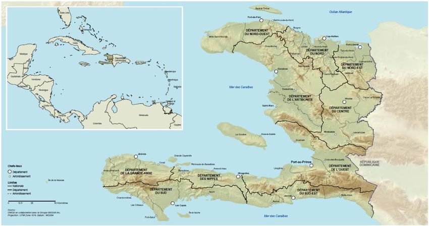
Project Full document                                                                                                                 v.05: January 12, 2020

List of acronyms and abbreviations
      Acronym               Description
      AF                    Adaptation Fund
      CC                    Climate Change
      CCA                   Climate Change Adaptation
      CSSF                  Comprehensive School Safety Framework
      DRR                   Disaster Risk Reduction
      MARNDR                Ministry of Agriculture, Natural Resources and Rural Development
      MAST                  Ministry of Social Affairs and Labor
      MEL                   Monitoring, Evaluation and Learning
      MTPTCE                Ministry of Public Works, Transport, Communication and Energy
      NAPA                  National Adaptation Action Plan
      NDC                   National Development Contribution
      PARDH                 Action Plan for the Recovery and Development of Haiti
      PNGRD                 National Risk and Disaster Management Plan
      PSDH                  Strategic Development Plan of Haiti (Plan Stratégique de Développement d’Haïti)
      UNDAF                 United Nations Development Assistance Framework
      UNDP                  United Nations Development Programme
      UNESCO                United Nations Educational, Scientific and Cultural Organisation
      UNOPS                 United Nations Office for Project Services
      SDG                   Sustainable Development Goals
      ToT                   Training of Trainers
      VISUS                 Visual Inspection for the definition of Safety Upgrading Strategies

List of Figures
    Figure I-1 Map of ten departments of Haiti ...................................................................................................................6
    Figure I-2 Temperature changes expected for the Decade 2041-2050 (Ministry of the Environment, 2009). ............7
    Figure I-4 Frequency of cyclones in Haiti's geographical department . .........................................................................9
    Figure I-5 Inform Risk Index 2018. ...............................................................................................................................11
    Figure I-6: Comprehensive School Safety Framework (CSSF) ......................................................................................12
    Figure I-7 Theory of change .........................................................................................................................................16
    Figure II-1: A rational approach to prioritize school intervention to maximize the cost-effectiveness ......................28
    Figure II-2 Water balance for the reference periods. ..................................................................................................39

List of Tables
    Table I-1 Project Information.........................................................................................................................................4
    Table I-2 Statistics of departments of Haiti ...................................................................................................................5
    Table I-3 Severity of disasters in the departments of Haiti (1 = maximum risk, 10 = minimum risk) ...........................8
    Table I-4 Major Hurricanes that hit Haiti. ......................................................................................................................8
    Table I-5 Project Components and Financing ..............................................................................................................15
    Table I-6 Projected calendar ........................................................................................................................................15
    Table II-1 Economic, social and environmental benefits .............................................................................................25
    Table II-2 Checklist of environmental and social principles .........................................................................................46
    Table III-1 Results Framework .............................................................................................. Erreur ! Signet non défini.

                                                                                                                                                                        3
Project Full document                                                    v.05: January 12, 2020

 PROJECT/PROGRAMME PROPOSAL TO THE ADAPTATION FUND

PART I: PROJECT INFORMATION

    Project Category:                        Regular Project Concept
    Country:                                 Haiti
    Title of Project:                       Implementing Measures for Climate Change
                                            Adaptation and Disaster Risk Reduction
                                            Mitigation of School Facilities in Haiti
    Type of Implementing Entity:             Multilateral Implementing Entity
    Implementing Entity:                    United Nations Educational, Scientific and
                                            Cultural Organisation (UNESCO)
    Executing Entity:                        United Nations Office for Project Services
                                            (UNOPS)
    Amount of Financing Requested:           US$ 9.890.000 (in U.S Dollars Equivalent)
                                   Table I-1 Project Information

                                                                                             4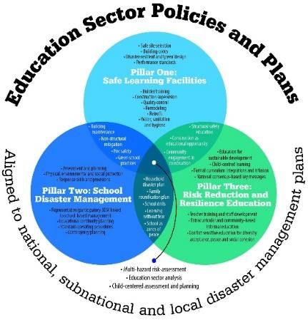
Project Full document                                                                  v.05: January 12, 2020

Project Background and Context
     Provide brief information on the problem the proposed project is aiming to solve. Outline the economic
     social, development and environmental context in which the project would operate.

a. Brief project area context
1.   Haiti, officially the Republic of Haiti with the capital Port au Prince, is a Caribbean country located
     on the west side of the island of Hispaniola, east of Cuba in the islands of the Caribbean Sea. It
     occupies three eighths of the island; the remaining area is the Dominican Republic.
2.   Haiti covers 27,750 square kilometers and has approximately 10.2 million inhabitants. The
     country is located along a peninsula within Hispaniola, in the shape of a horseshoe, and has 1,771
     km of coastline.
3.   The country's topography is mostly characterized by rugged mountains and, fertile river valleys.
     With approximately 70% of the island covered by mountains, most people live along the coast.
     The highest point of Haiti is Pic la Selle, reaching 2,680 meters.
4.   The Decree of 30 October 2003 covering the territory of the fixed division cutting of Haiti in ten
     (10) departments, forty-two (42) districts, one hundred forty (140) towns, five hundred seventy
     ( 570) communal sections1.
          IHSI Code2    Department        Chef-Lieu or             Area         Population      Density /
                                              Capital              (km)            (2002)         km²
               5          Artibonite         Gonaïves              4984           1168800        234.5
               6           Center             Hinche               3675           564200         153.5
               8         Grand'Anse           Jeremi               1871           733000         391.7
              10            Duds            Miragoâne              1268           266379         210.0
               3            North          Cap-Haitien             2106           872200         414.2
               4          Northeast        Fort Liberté            1805           283800         157.2
               9         North West       Port-de-Paix             2176           488500         224.5
               1            WEst         Port au Prince            4827           2943200        609.7
               7           South            Les Cayes              2794           745000         266.6
               2         South East           Jacmel               2023           518200          256,
                                     Table I-2 Statistics of departments of Haiti

     1   The Decree of 30 October 2003 on the division of the territory of Haiti
     2   http://www.ihsi.ht/pdf/Methodes_et_procedures/Manuel_instruct_agents_codifi(RGPH2003).

                                                                                                            5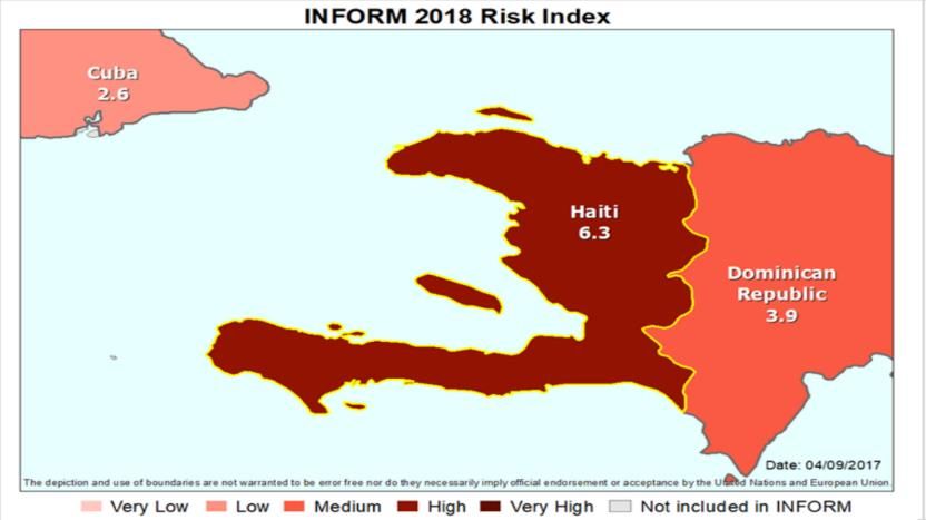
Project Full document                                                              v.05: January 12, 2020

                                    Figure I-1 Map of departments of Haiti
5.   The climate of Haiti is mainly tropical with distinct climatic zones that allow a wide variety of
     biodiversity. Vegetation is characterized by bushes, conifers and mangrove. The rainy season in
     most parts of Haiti is between May and November. Haiti is exposed to various natural hazards,
     namely hurricanes, floods, volcanic eruptions, earthquakes, tsunamis, landslides, droughts and
     fires. These risks have compromised the strategies of poverty reduction in the country, impeded
     progress, and endangered development of education systems. Their impact can be amplified by
     the expected effects of changes in the global climate and extreme weather events that will
     potentially become more frequent and severe.
6.   As a small island developing state, due to climate change, Haiti is exposed to the threat of sea
     level rise, and to increasingly intense hurricanes and frequent tropical storms. Haiti is also
     particularly vulnerable to droughts, coastal erosion and landslides. These disasters can jeopardize
     the country’s food security, infrastructure, and the safety of the population. Haiti’s vulnerability
     to climate change is due to a combination of factors, ranging from its geographical location,
     deforestation and land degradation, to high poverty rates and weak institutional capacity.

b. Hydrography and climate context
7.  Because of its latitude, between latitudes 18o and 20o north, the country has a tropical climate
    characterized by alternating between a wet season and a dry season. In the plains, average
    temperatures vary between 28 ° C in winter and 32 ° C in summer.
8. On mountain tops, the temperature can fluctuate between 18 ° C and 22 ° C. Rainfall varies not
    only with altitude but also with the orientation of mountain ranges in relation to the trade winds
    from the Northeast.
9. Haiti is located in full trajectory of Atlantic tropical systems that affect the Caribbean each year
    is from June through November. Hurricane Jeanne in September 2004 was one of the deadliest
    in decades for Haiti. In 2008, the country has faced four successive hurricanes. More recently
    hurricane Matthew occurred in October 2016 decimated the deep south of the country, causing
    considerable damage.
10. Haiti is also exposed to periods of intense drought. The rainy season is now shorter. Some areas
    may not receive a drop of rain for several successive months. The country is divided into 30 major
    watersheds and river units of different sizes3: the largest is the Artibonite River that extends into
    the country's central region over an area of 6,435 km2, and the smallest is the Turtle River has an
    area of 179 km2.
11. The study of Socioeconomic Impacts of Climate Change in Haiti and Coping Responses4,
    Conducted jointly between the Ministry of Environment, Economic Commission for Latin America
    and the Caribbean, and UNDP, indicates that climate trends in the country are planning a
    considerable risk profile. Indeed, the progress scenarios project a temperature rise ranging from

     3The IDB and watersheds
     4 Temperature changes expected for the 2041-2050 decade (Ministry of Environment Haiti, 2009)
     http://www.social-protection.org/gimi/RessourceDownload.action?ressource.ressourceId=17690

                                                                                                       6
Project Full document                                                               v.05: January 12, 2020

    0.8 ° C to 1.0 ° C. According to the scenarios conducted on the first Communication5, climate
    change projected to Haiti indicates a temperature increase ranging from 0.8 ° C to 1.0 ° C for the
    year 2030; for the 2060 year, this increase will vary from 1.5 ° C to 1.7 ° C. These results are
    consistent with those of the temperature obtained by the application of models ACCURATE, that
    predict changes up to 1.7 degrees Celsius for a few months.

                         Figure I-2 Temperature changes expected for the Decade 2041-2050
                                        (Ministry of the Environment, 2009).
12. In addition, rain may decrease from year to year, depending on the area of the country, leading
    to phenomena of droughts and reduced adaptability by forests. Conversely, it should be noted
    that extreme precipitation events would quickly drain the water upstream and provoke floods
    downstream. The climate of Haiti has undergone several changes in recent times. According to
    data collected by the Ministry of Agriculture, Natural Resources and Rural Development
    (MARNDR)6of Haiti, the average temperature has increased by more than 1 degree between 1973
    and 2003.
13. The conditions of extreme and variable weather alternate between drought in the dry season
    (usually between December and April) and strong storms and hurricanes during the rainy season
    (usually between August and November). Changes in variability and extreme weather
    conditions are in line with the Fourth Assessment Report of the Intergovernmental Panel on
    Climate Change (IPCC)7 .For example, the report indicates that in 90s, 30% of cyclones have been
    classified category 4 or 5 compared to 20% in the ‘70s.
                        Department          hurricanes         floods             droughts
                         Artibonite             10                2                  3
                           Center                9                9                  6
                        Grande Anse              2                7                  9
                            duds                 5                8                  8
                           North                 7                5                  7
                         Northeast               8               10                  2
                        North West               6                4                  1
                            West                 4                1                  4

    5 The Kyoto Protocol was ratified by Haiti on 6 July 2005 and entered into force on 4 October 2005. The
    country has made and submitted its first National Communication to the UNFCCC in August 2001 and the
    second in October 2013
    6 Unite statistique agricole et informatique MARNDR Haiti
    7 The Intergovernmental Panel on Climate Change (IPCC) is the United Nations body for Assessing the

    science related to climate change.

                                                                                                         7
Project Full document                                                                        v.05: January 12, 2020

                          South                    1                   3                   10
                        South East                 3                   6                   5
          Table I-3 Severity of disasters in the departments of Haiti (1 = maximum risk, 10 = minimum risk) 8
14. During the 20th century, Haiti was hit by 34 storms, cyclones or hurricanes. About 80% of them
    took place after 1954 and 44% of these were recorded in the 90s9. Just in 2016, the hurricane
    season evaluation report shows a balance of 546 dead, 128 missing, 439 injured and 2.1 million
    people affected.
      Date                                                           Speed                             Damages
                        Name              Areas affected                         Dead    Disaster
  (dd/mm/yyyy)                                                      (Km / h)                          (US $ 1000)
    08/12/1915           n/a     Peninsula’s southern portion          76        1600        n/a         n/a
         1935            n/a     South, Southeast, Grand Anse          n/a       2150        n/a         n/a
    12/10/1954          Hazel    South Grand Anse, Port-au-Prince     n/a          410   250000          n/a
    03/10/1963          Flora    South-East Zone                      240         5000     n/a         180 000
    24/08/1964          Cleo     Cayes Camp-Perrin Arniquet           150          100   80000          10000
                                 South, Port-au-Prince of Marigot
    29/09/1966          Inez                                        120-190        480   67000          20000
                                 Grand Goave
    13/11/1994         Gordon    All the territory                    n/a         1122     n/a           n/a
    22/09/1998         Georges   All the territory                    n/a          242   385000     80 000-180 000
                                         Table I-4 Major Hurricanes that hit Haiti.
15. Considering only the major hurricanes, of the 39 recorded between 1700 and 1997, 15 of them
    have been between 1900 and 1997. Therefore, it is possible to experience a cyclone in Haiti every
    six to seven years. The damage caused by these phenomena, as well as by those resulting from
    heavy rainfall, can affect the entire country. The devastating winds can affect any part of the
    country, although the central and northern regions are best preserved of the most violent winds.
    Considering only the major events such as hurricanes, tropical storms and depressions, that
    occurred in the last 50 years, the country’s most threatened area is the Southern peninsula (Table
    3 & Figure 1). All catastrophic hurricanes that struck Haiti hit the South.Additionally, it is subject
    to very localized nature of events such as tornadoes and gales. It is estimated that nearly 2 million
    Haitians per year are subject to the risk of cyclones and hurricanes.

    8   Source: Haiti Lifeline / FOE Haiti, "The Events of Climate Change in Haiti", 2006.
    9   Oxfam Maps and study of risks, vulnerability and response capacity in Haiti

                                                                                                                    8
Project Full document                                                                   v.05: January 12, 2020

                             Figure I-3 Frequency of cyclones in Haiti's departments.

c. Economic, social and environmental context
      Vulnerability socio-political history of the country
16.   Haiti, a former French and Spanish colony, obtained its independence since 1804. However, the
      country could not capitalize on the opportunities offered by socio-political independence. It
      quickly evolved into a cycle of violent dictatorial regimes and a series of military coup. In 1990
      the country recorded a precarious democratic transition followed by a series of post-election
      violence and an unprecedented institutional instability making the country ungovernable.
17.   This has resulted in a political stalemate punctuated by long social crises that lasted until 2015.
      Today, although the socio-political situation becomes calmer and more stable, it is recognized
      that challenges remain in governance of the country. Similarly, the establishment of a political,
      institutional and legal MfDR was not helped by this unstable context.
      Population vulnerability
18.   In 2015, the population was estimated at approximately 10,512,474 inhabitants (IHSI, 2015). The
      country has the highest population density in the region (or 379 people per km 2). The annual
      growth rate of population is 1.3%. The Haitian population is mainly characterized by its youth.
      Children and young people under 25 represent over 56% of the total population. There are 86
      men for every 100 women in urban areas and 98 men per 100 women in rural areas.
19.   Population projections indicate that in 2050, the Haitian population could exceed 16 million. In
      2030, the urban population would consolidate over 60% of Haitians and by 2050 over 70% (IHSI,
      2015). This urban trend could increase vulnerability to natural disasters centered on cities if
      mitigation measures are not planned in terms of urban development, organization of space, and
      promotion of building standards for human settlements etc.
      Societal Context
20.   Haiti is one of the poorest countries in the world. About a quarter of the population lives on less
      than $ 1.25 a day (Sustainable Development Framework, 2016). The same document indicates
      that the monetary poverty rate is estimated at 58.6% and is about 6.3 million in the same period.
21.   The national economy is strongly driven by the service sector. The latter, which covers 59% of
      GDP is mainly based on services such as catering, hotels, financial institutions, transportation etc.

                                                                                                            9
Project Full document                                                             v.05: January 12, 2020

22. The primary sector, which mainly employs vulnerable groups account for 23 to 25% of GDP. The
    sector employs over 70% of the population, particularly the poorest. It is mainly rural and
    agricultural. Indeed, more than half of Haiti's population (between 5 and 6 million) live in rural
    areas and nearly 85% of the population practice farming.
23. The secondary sector contributes 18% of GDP and is related to the processing of raw materials.
    In recent years, in favor of post-seismic reconstruction projects, the construction sector and
    Public Works (BTP) has largely contributed to the growth of the economy.
24. From the above, one can note that the Haitian economy is not pro-poor and it mostly benefits
    the wealthy classes. Moreover, it is comparatively extroverted and is not inclusive enough. Thus,
    it is not a robust resilience floor for the most vulnerable to disasters.

d. Disaster and CC risk
25. Haiti is subject to a range of natural hazards that may be of hydro meteorological or geodynamic
    origin. Haiti is considered the fifth country more exposed to the risk of disasters worldwide.
    Nearly 98% of the population is exposed to at least two natural hazards: earthquakes, hurricanes,
    landslides, floods and/or drought. Indeed, more than a hundred disasters hit the country in the
    years 1900-201610.
26. These disasters have so often ravaged several cities. Example include an earthquake of
    magnitude 7.0(Mw), nearly 40 cyclones, over fifty floods, seven periods of drought.
27. According to EM-DAT11 96% of Haiti's population lives in area exposed to two risks of disasters.
    The country has an index of vulnerability to cyclones of 12.9 on a scale of 13 and ranks first in
    terms of vulnerability to cyclones in the region of small island states.
28. The global index on climate change indicates that the country ranks 3rd among the most affected
    by the effects of extreme weather events worldwide. In the Caribbean countries, Haiti is the one
    that suffers the highest number of disasters per square kilometer12.
29. In 2018, the figures for the index of vulnerability to natural disasters and humanitarian crises
    published by the Group INFORM13show that the country's vulnerable situation has not changed
    much. In this index, Haiti is in 14th place globally out of 119, and in first place in the Region of
    Latin America and Caribbean (LAC).

    10 UN Office for Disaster Risk Reduction, Government of Haiti Document Country for Disaster Risk
    Reduction: Haiti, 2016
    11 Emergency Events Database (EM-DAT) https://www.cred.be/projects/EM-DAT
    12 Source link
    13 INFORM is an open source method for quantitative risk assessment crisis and disaster. The results

    obtained with this tool can support decision making prevention

                                                                                                     10
Project Full document v.05: January 12, 2020
Figure I-4 Inform Risk Index 2018.
30. According to the World Bank, 56% of the country's production of GDP are located in areas at risk
of disaster. To this end, it notes that the recurrent flooding would cause an economic impact of
2% of GDP (World Bank, 2014).
31. According to the analysis of historical data disasters made by the GFDRR14, it was estimated that
losses from extreme events, of the hydro meteorological kind amounted to 150 million USD per
year on average. Moreover, the average annual damage associated with tropical cyclones are
estimated over a period of 10 years at more than 442 million USD per year.
32. Chronic food insecurity related to drought affects all areas in livelihood of the country,
approximately 70% of the population. More than three million people were in moderate or
severe chronic food insecurity in 2016 and 9 out of 10 departments are periodically under stress
(CNSA15). As for chronic malnutrition, approximately 22% of children under 5 years of age are
affected. The moderate or severe food insecurity affected 3.2 million people (or 29% of the total
population), of which 2.8 million moderately malnourished and 4.5 million were severely
malnourished.
33. Flooding is a major problem in almost all the 30 largest rivers in Haiti due to heavy seasonal rains,
the occurrence of storm in coastal areas, eroded and deforested landscape, and river
sedimentation. Coastal cities with large concentrations of people such as Jacmel, Les Cayes, and
Gonaives are in the direct path of storms.
34. The coastal plains contain important aquifers that are more prone to salinization and as soils
become saltier, resulting from rising sea levels, they will no longer be cultivable, which may cause
significant economic regressions. Communities with low incomes located near rivers and coastal
plains live the bitter experience of significant loss of human life during the hurricane season due
to flooding and powerful gusty winds. The subsequent flooding downpours also affect public
health: they facilitate the spread of diseases such as cholera.
e. Impact on school safety
35. Disasters have a major impact on children, youth and education systems. Studies suggest that in
the world every year 175 million children are likely to be affected by natural hazards leading to
14Global Facility for Disaster Reduction and Recovery (GFDRR)
15National Coordination for Food Security (CNSA) institution of the Haitian state is to influence public
policies to sustainably improve food security conditions of the Haitian population.
11Project Full document v.05: January 12, 2020
disaster, and children in Haiti are no exception. In January 2010, approximately 38,000 students
and 1,300 teachers and education personnel died in Haiti. The Ministry of Education offices were
destroyed along with 4,000 schools – close to 80 % of educational establishments in the Port-au-
Prince area.
36. In 2016, hurricane Matthew struck Haiti and caused significant physical damage to Haiti's
education sector, as concluded by an assessment by the MENFP16. An average figure estimated
that 3,452 schools were affected and 521 schools were completely destroyed. The cost of
damage due to the hurricanes on schools in the southern departments reached an estimated $
62.9 million U.S. dollars. On average, one school out of four was damaged.
37. Many of these schools are still used as temporary shelter, or as evacuation shelters.17
38. In Haiti, technical and financial resources are scarce or unavailable to perform tasks on a
standalone basis. Despite this, the main strategies have been implemented to improve school
adaptation, mitigation and preparedness. A comprehensive education sector safety strategy
contains three overlapping areas of focus: Safe School Facilities, School Disaster Management
and Disaster Prevention Education. Enveloping these three pillars are education policies and
plans at the government level, ideally undertaking systematic analysis of threats to school and
system safety and developing policy and plans that address each of these three areas.
Figure I-5: Comprehensive School Safety Framework (CSSF)
39. Recognizing that school age children spend the majority of their waking hours at school, there is
always a high possibility that a natural hazard strike while they are at school. Therefore, school
facilities need to be protected from disasters as they save lives of children and they can also assist
as temporary shelter in post disaster scenario. Safer schools are necessary to prevent lives of
children during natural hazards events. The concept of school safety, however, is not limited to
preventing the collapse of school buildings in disasters, and safety of teachers and students, but
rather extends to meet the broader goal “disaster risk management”.
40. Moreover, resilient schools are an effective medium for disseminating disaster risk reduction
awareness in the communities, can act as center of learning, may be instrumental in the transfer
of technology to the communities and have significant role in building disaster resilient
16 Ministry of National Education and Vocational Training (MENFP) post Hurricane Matthew evaluation
report
1780% of spaces that are used as post disaster evacuation shelters are public schools. Sources National
Plan for the Management of Risks and Disasters. PNGRD Haiti
12Project Full document v.05: January 12, 2020
communities. The activities like retrofitting of a school and new construction with safety
measures can spread the message to the community of the importance of resilient buildings to
reduce disaster impacts.
Project Objectives
List the main objectives of the project
41. The aim of the project is to enhance the adaptive capacity and resilience of the Haitian education
sector to disaster risk of natural hazards related to climate change, through the establishment of
appropriate risk assessment tool, schools retrofitting and implementing adaptation actions in
Haiti.
42. The project promotes and adopt innovative, structural and non-structural resilient resolutions.
More specifically, this project is intended to strengthen the resilience to hurricane and flood of
the Haitian education sector by:
Improving the national comprehensive knowledge of exposure and physical vulnerability
of school facilities and decision-making process of intervention in Haiti;
Strengthening school safety by promoting rehabilitation, retrofitting, reconstruction or
relocation on selected schools and risk management protocols for schools;
Enhancing the capacity and awareness of the local population and civil protection
stakeholders in risk management at national and local levels;
Project Components and Financing
Fill in the table presenting the relationships among project components, activities, expected concrete
outputs, and the corresponding budgets. If necessary, please refer to the attached instructions for a detailed
description of each term.
Project Components Expected Concrete Outputs Expected Outcomes Amount (US$)
Component 1 Output 1.1 Outcome 1 20.000
Assessment of school Improve trainers competence to Improve the
facilities by VISUS provide inclusive, technical and national knowledge
methodology effective training to the exposure and
Output 1.2 physical 30.000
Enhance decision makers vulnerability of
understanding of the VISUS approach school facilities and
Output 1.3 capacity of the 50.000
VISUS surveyors know-how to decision process of
transfer to university students intervention in Haiti
Output 1.4 600.000
Assess the exposure and vulnerability
of school facilities
Output 1.5 50.000
Put on place GIS-based web platform
knowledge-sharing
Output 1.6 20.000
13Project Full document v.05: January 12, 2020
Develop Strategic intervention plan
for school facilities
Component 2 Output 2.1 Outcome 2 550.000
Schools adaptation and Design detailed intervention of the Strengthening the
safety Improvement selected schools school safety by
Output 2.2 promoting 5.500.000
Implement Adaptation, rehabilitation,
Rehabilitation, retrofitting, retrofitting,
reconstruction or relocation of school reconstruction or
facilities relocation on
Output 2.3 selected schools and 50.000
Improve trainers competence to risk management
provide inclusive, technical and school protocols
effective training
Output 2.4 200.000
Good DRR and CCA practices are
adopted by students and school staffs
Output 2.5 100.000
Adopt risk management school
protocols
Component 3 Output 3.1 Outcome 3 50.000
Enhancement of the Enhance knowledge and awareness of Enhancing the
climate resilience of social the disaster risk due to CC in Haiti capacity and
community through the Output 3.2 awareness of local 300.000
educational sector Community emergency plan population and civil
Output 3.3 protection 500.000
Put on place community capacity to stakeholders in risk
cope with disasters improved management at
Output 3.4 national and local 300.000
National action plan for resilient levels
schools facilities and their
surrounding communities.
Component 4 : Monitoring Output 4.1 20.000
and evaluation Assessment of VISUS methodology in
the schools
Output 4.2 30.000
Assessment and monitoring the safety
level of the schools
Output 4.3 30.000
Assessment and monitoring
enhancement level of climate
resilience of school communities
6. Project Execution cost (9.5%) 785.000
7. Total Project Cost 8.320.000
8. Project Cycle Management Fee charged by the Implementing Entity (8.5%) 705.000
Amount of Financing Requested 9.890.000
14Project Full document v.05: January 12, 2020
Table I-5 Project Components and Financing
43. The components of the project are developed following the process of change outlined by the
causal linkages between the outputs and the hypothesis behind each single step. Figure I-6
presents the Theory of Change of the proposed project.
44. The project is aligned with AF’s results framework at outcome level. In particular:
AF’s Outcome 1: the VISUS assessment and the interventions of component 2 will reduced
exposure to climate-related hazards and threats;
AF’s Outcome 2: the project component 2 will strengthen institutional capacity to reduce
risks associated with climate-induced socioeconomic and environmental losses related to
the education sector;
AF’s Outcome 3: the local scale of school’ interventions of component 2, the training
program and the assessment of component 1 will strengthen awareness and ownership
of adaptation and climate risk reduction processes at local level;
AF’s Outcome 4: all the project components aim to increase the adaptive capacity within
education infrastructure and services;
AF’s Outcome 7: the project component 3 aims to improved policies and regulations that
promote and enforce resilience measures at national level in the education sector.
Projected Calendar
Indicate the dates of the following milestones for the proposed project/programme
Milestones Expected Dates
Start of Project/Program Implementation October, 2020
Mid-term Review (if planned) November, 2021
Project/Program Closing October, 2023
Terminal Evaluation 2024
Table I-6 Projected calendar
15Education Sector Exteded School Comunity
Present The Haitian Education sector is exposed and vulnerable to multi-
situatin hazards climated related risk
so that University students, professionals and decision makers come to
(A) training on school facilities assessment of multi-risks
Project Full document
so that They will be able to assess with standardized methodology the Present
The Haitian communities are aware of the risks that are exposed
(B) vulnerability and exposure of the facilities situatin
so that, Decision makers will have the knowledge, competence and Comes to workshops and trainings to enhance their knowledge and
so that (i)
Outcome 1 information to develop a strategic intervention plan awareness on the effects of climate change
With limited budget, the adaptation and rehabilitation of the physical
so that The decision makers will promote the development of emergency
vulnerability of the most relevant facilities will have the highest so that (ii)
(C) plan involving the extended community of the rehabilitated schools
impact
so that Students and schools staff can come to trainings/courses and do
so that (iii) The extended population learn how to behave in case of emergency
(D) simulation of CCA and DRR practice inside the rehabilitated schools
so that The risk management schools protocals and CCA actions implemented The population will properly use the school facilities as temporary
so that (iv)
(E) can be efficacely adopted by the people in the shools shelters during extreme events
so that, so that,
The safeness and resilience of people inside the school increases The safeness of extended population increases
Outcome 2 Outcome 3
so that
Haitian education sector enhances the resilience to disaster risk of natural hazards related to climate change
( AIM )
The hypothesis behind the So that Chain are:
Figure I-6 Theory of change
Students, professionals and decision makers accept to use the VISUS
A
methodology as school assessment tool
B The trainings have transferred the methodology to the surveyors
The decision makers agree to develop the strategy based on the input Haitian people recognize that the climate change will increase the
Outcome 1
of the methodology I hazards of their communities
The rehabilitation interventions will be implemented accordingly to The extended communities is involved in the development process
C
the designs II of emergency plan
People in the schools recognized the importance of knowing how to The extended communities recognize the values of adopt
D
behave in case of emergency and how to adapt to CC III appropriate behave in case of emergency
The retrofitted and adapted schools has implemented a emergency The extended communities and the retrofitted schools agree on
E
protocols and courses on CC related topics IV common protocols in case of emergency
People in the rehabilitated schools apply the emergency protocols The extended population in the rehabilitated schools apply the
Outcome 2 Outcome 3
during the next events and implement CCA actions emergency protocols during the next events
AIM Haitian education sectors is supported by other national sectors (e.g. economy, civil protections, etc.) to promote the resilience in the communities
v.05: January 12, 2020
16Project Full document v.05: January 12, 2020
PART II: PROJECT JUSTIFICATION
A. Project Components
Describe the project components, particularly focusing on the concrete adaptation activities of the project,
and how these activities contribute to climate resilience.
45. The project is extremely important for enhancing the national resilience of Haiti by increasing the
capacity to absorb and react to the extreme events increased by climate change. In fact, these
event are constantly challenging the country and are becoming one of the major restraints for a
sustainable development. The project aims to enhance the adaptive capacity and resilience to
disaster risk of natural hazards focusing on the Haitian education sector. The project aims at the
achievement of the following three major objectives: 1) Improve the national knowledge of
exposure and physical vulnerability of school facilities and capacity of the decision-making
process of intervention in Haiti; 2) Strengthen the school safety by promoting rehabilitation,
retrofitting, reconstruction or relocation on selected schools and implementing school protocols
for risk management school; 3) Enhance the capacity and awareness of the local population and
civil protection stakeholders in risk management at national and local levels. These objectives
will be achieved through three interlinked components:
Component 1: Assessment of school facilities by VISUS methodology
Component 2: Improvement of schools safety
Component 3: Enhancement of climate resilience of social community through the
educational sector.
46. The components have been designed to translate the four rebuilding pillars (i.e. territorial
rebuilding, economic rebuilding, social rebuilding and institutional rebuilding) of the Strategic
Development Plan of Haiti into concrete action on the ground. The project components respond
to this plan by immediately increasing the resilience of some prioritized schools by adopting a
long-term development perspective.
Component 1: Assessment of school facilities by VISUS methodology
47. Component 1 specifically responds to the first of three objectives of the project: Improved the
national knowledge of exposure and physical vulnerability of school facilities and capacity of the
decision-making process of intervention in Haiti.
48. Haiti is very vulnerable to extreme events due to climate change and the education sector is not
far behind, as recent event unfortunately confirms. In order to increase the resilience of Haiti, in
particular the resilience of the education sector, this component aims to improve the
competence and the knowledge of local technical experts. These specific competences will allow
to assess the vulnerability of the school facilities across the country, this knowledge is the first
step to start a proper implementation of interventions of rehabilitation. The assessment will be
17Project Full document v.05: January 12, 2020
based on the VISUS18 methodology, a Visual Inspection for the definition of Safety Upgrading
Strategies, that allows to rank the priority interventions, and to define specific actions required
and how much they would cost. This classification will be the base for the development of
strategy of intervention that is implemented by Component 2.
49. Component 1 contains 6 outputs described below.
Output 1.1: Trainers competence to provide inclusive, technical and effective training is
improved
50. The Training of Trainers (ToT) is a strong predictor of sustainability of this project because it will
allow to up-skilling the workforce rapidly, at a low cost and exponentially by developing local
educators. The provides participants with horizontal and crossing information and skills to plan,
to develop, and to mainstream active participation, with gender and youth inclusion in their
trainings. Further the horizontal information, the ToTs will provide vertical competence on the
multi-risk of Haiti and the VISUS technical guidelines, characterization and standards for the
multi-hazard assessment of school facilities in Haiti.
51. Indicative activities:
Identify and map national, regional (department) and local organizations mandated to
work on DRR, including climate related risks;
Identify and select trainer of trainers that could be nationwide representative;
A ToT at the beginning of the project;
A second ToT planned after the first trainings implementation to share lesson learnt and
if necessary to review the methods.
Output 1.2: Decision makers understanding of the VISUS approach enhanced
52. VISUS is especially addressed to stakeholders from the Ministry of Education, National Disaster
Management Authorities and other relevant institutions to help them in understanding which
schools need priority interventions, which specific actions are required and how much they
would cost. The very comprehensive VISUS assessment provide a large amount of information
and a set of indicators used to support decision-makers in the definition of safety upgrading
strategies. They are presented in a collective report with the outcomes for the entire analysed
geographical area along with individual reports illustrating the situation of each of the inspected
schools. The assessment becomes concrete action put in place as soon as the decision makers
start to make strategical decisions based on the results from the VISUS approach. For this reason,
it is important that the value and power of the methodology is clearly transferred to those figures
are more related to the schools’ safety in Haiti.
53. Indicative activities:
Identify the national and regional Haitian offices mandated to work on the education
sectors, DRR and climate related risks;
Identify and select the relevant decision-makers that could benefit from the adoption of
the VISUS methodology;
18 UNESCO Guidelines for Assessing Learning Facilities in the Context of Disaster Risk Reduction and
Climate Change Adaptation: VOLUME 1: Introduction to learning facilities assessment and to the VISUS
methodology; VOLUME 2: VISUS Methodology; VOLUME 3: VISUS Implementation
18Project Full document v.05: January 12, 2020
A training on how to use the outputs of the VISUS assessments;
Final workshop on the results of the AF application project.
Output 1.3: VISUS surveyors’ know-how is transferred to university students
54. The survey phase is carried out by trained VISUS surveyors, who collect information for each
school using the pre-codified VISUS survey forms. For this reason, it is important to introduce the
VISUS methodology to lecturers, researchers, practitioners, and students for them to use the
survey tools and to take the lead in assessing the schools safety during the field survey.
55. Indicative activities:
Identify the national university student courses and technical organizations that will be
interested and appropriate to be involved in the surveys;
Capacity building of local engineers, architects, geologist, student etc., that will perform
assessment of schools
Training to the teams that will perform the assessment at the school level.
Production of technic guidelines for the assessment of school facilities
Output 1.4: Exposure and vulnerability of school facilities are assessed
56. The core of the first outcome is the implementation of the VISUS assessment in the selected
750/1000 schools in those areas of the country that are more exposed to extreme hazard as
underlined in the project background. The assessment surveys will be carried out by trained team
of four people, consisting of three students and one professor. The inspectors from related
ministries or national institutions, and/or final year civil engineering or architecture students of
local universities will collect information for each school using the pre-codified VISUS survey
forms.
57. Indicative activities:
Elaboration of a plan and a schedule for the implementation of the assessment by
geographical localities and number of teams;
Implementation of the assessment by survey teams;
Selection of schools that will need a further and deeper assessment investigation.
Implementation of a more detailed assessment to the previous selected schools that will
be performed by particular specialists.
Output 1.5: GIS-based web platform knowledge-sharing is put on place
58. The pre-codified VISUS survey will allow to collect all the assessments in the same format and
will allow for comparing them. To facilitate the consultation and the knowledge-sharing between
stakeholders all the evaluation will be uploaded in a geographical web-platform. The geographic
information system will show, in addition to its location, the individual report of each single
assessed school and the relative collective report that allow to easily compare it with other
schools.
59. Indicative activities:
Elaborate a Geo-spatial inventory of schools and a comprehensive school-mapping of
Haiti.
19Project Full document v.05: January 12, 2020
Output 1.6: Strategic intervention plan for school facilities is developed
60. The first and second outcomes are linked by the development of a strategic intervention plan
based on the outputs of the VISUS methodology. Public administrations are facing a complex
problem and they often need to answer the following questions: which school must be addressed
first? Why? What typologies of interventions are necessary? Wichi level of safety may be
reached? How much is the cost of retrofitting? How many interventions can be managed with
the available resources? These questions point out that the definition of a rational and effective
strategy for the mitigation of natural hazards risk implies the necessity to know the level of risk
and the criticalities together with the required countermeasures and their costs. All this
knowledge provided by the VISUS assessment permits to perform an evaluation of the
economical effort needed in terms of the necessary global financial amount and, consequently,
the definition of the feasible strategies for building a resilient school sector and enhance adaptive
community.
61. Indicative activities:
Identification and maps of the schools, areas, regions, and localities; that will need urgent
intervention.
Workshop with the relevant stakeholder to discuss the assessment results
Selection of schools that could be used as temporary community shelters (even if is not
recommended), and reinforcement of their physical capacities to meet these special
needs. The schools considered in this project will be strengthen at the level that they can
be used as shelter, but the project will encourage that this will be for a minimal time in
order to not compromise the right to education.
Definition of a strategy for intervention.
Component 2: Schools adaptation and safety improvement
62. The objective of Component 2 is to strengthen the school safety by promoting rehabilitation,
retrofitting, reconstruction of relocation on selected schools and implementing school protocols
for risk management. The budget allocated for this component allow to intervene only on some
off all the 750/1000 schools assessed in Component 1. More specifically, 10% of this budget will
be used to adapt and rehabilitate schools based on the VISUS assessment carried out in 2017
(precedent project). The remaining 90% will be used to rehabilitate between 15 to 30 schools
that have at least 300 students and that require light level of interventions, each with an
estimated budget between 100K$ and 200K$; 5 to 10 schools that have at least 450 students and
the require medium level of interventions, each with an estimated budget between 200K$ and
400K$; finally, 2 to 3 schools that have at least 800 students and the require heavy level of
interventions, each with an estimated budget between 400K$ and 600K$. The level of
interventions and budget estimates are provided by the VISUS methodology.
63. Component 2 contains 5 outputs as described below.
Output 2.1: Detailed intervention of the selected schools are designed
64. The strategy of intervention defined in the first component propose a list of interventions
according to the VISUS assessment and provides the estimated costs. The first output of
Component 2 is the detailed design of the upgrading level of safety of learning facilities
20Project Full document v.05: January 12, 2020
accordingly to the developed strategy. The detailed intervention will also consider the integration
of the school intervention with possible nature-based infrastructure, such as planting trees at a
safe distance from the school to reduce wind speed, ensuring there are permeable surfaces
outside of the school that can absorb water. In fact, only after this step will be possible to confirm
the exact number of intervention and establish each specific subcontract for the individual
intervention.
65. Indicative activities:
Detailed designs of all schools considered in the strategy
Detailed BOQ and budget estimates for each intervention
Execute the subcontracts for the selected interventions
Output 2.2: Adaptation, rehabilitation or retrofitting of school facilities are implemented
66. According to the detailed designs of the previous output, it will be possible to implement
interventions that are considered strategic in order to adapt and improve the schools’ safety. The
actions will first upgrade the safety of students within the schools and also people that will use
the facilities as shelter areas. Furthermore, some interventions will allow the school facilities to
better adapt to the adverse and extreme conditions exacerbated by climate change. Some of
these interventions will include the installation of water harvestings tanks (e.g. bathrooms for
girls and for emergency situations during which the schools will be used as shelter) and
renewable energy systems for consumption in the school (is is noted that schools do not have
electricity at nights).
67. Indicative activities:
Schedule the work without interrupting the education service provided to students
Implement the interventions to upgrade the safety of school facilities
Implement the necessary adaptation interventions
Output 2.3: Trainers competence to provide inclusive, technical and effective training is
improved
68. As for Outcome 1.1, the ToT provide participants with horizontal and crossing information and
skills to plan, develop and to mainstream active participation, with gender and youth inclusion,
in their trainings. The construction sector is extremely sensitive to these issues, for this reason
the project proposes specific ToT integrated with vertical construction competences.
69. Indicative activities:
Identify and map national, regional (department) and local organizations mandated to
work on constructions;
Identify and select trainer of trainers that could be nationwide representative;
A ToT at the beginning of the project;
Output 2.4: Good DRR and CCA practices are adopted by students and school staff
The people’s safety within the schools is not only obtained by decreasing the vulnerability of the
building (Output 2.1) but also by transferring appropriate behaviors to students and adults who
are in the facilities. People trained are able to recognize the risk and individually adopt measures
and behaviours to reduce their exposure and vulnerability. This output will be integrated with
21Project Full document v.05: January 12, 2020
the activities of UNESCO with the Civil Protection Department, the Ministry of Education and the
Ministry of the Environment in the development of a strategic document that defines the
priorities in the short, medium and long term and the development of a training module for DRR
for teachers, school principals, students and parents. This training module is divided into four
blocks with the following contents: Block 1: The basic concepts in risk management and disaster;
Block 2: understand and deal with the risks of disasters in Haiti; Block 3: Reducing risks and
disasters in the school and its environment; Block 4: Training and awareness to reduce disaster
risk in schools. Furthermore, specific sciences laboratories to transfer knowledge related to
climate change and appropriate behaviors on how to adapt to the new climate challenges will be
provided to students.
70. Indicative activities:
Training programs on how to behave in case of hazardous events tailored to students and
school staff;
Plan an internal simulation of emergency along with school representatives;
Establish laboratories related to the climate change sciences.
Output 2.5: School protocols for risk management are adopted
71. Simple actions at school level can make a great difference in safeguarding people, vital records,
manuals, notebooks and furniture and equipment. This output aims at increasing the schools’
capacities by developing and implementing emergency preparedness and management plans
and identify the School Emergency Response Teams (SERT).
72. Indicative activities:
Review of the existing information regarding local hazard and historical events
Internal workshop with school’ personnel, local authorities, and major stakeholders to
collect information
Establish an emergency plan for schools’ facilities
Install warning messages and instructions within the schools
Component 3: Enhancement of climate resilience of social community through the educational
sector
73. The third component aims to transform the education sector in a community resilience source
built around the schools. The object of this component is to enhance the capacity and awareness
of the local population and civil protection stakeholders in risk management at national and local
levels.
74. The project has the ambition to bridge gaps from assessment to practice, and from knowledge
to action. The project will make the information of assessment available to all stakeholders,
because information is an essential forerunner to risk reduction and mitigation. Through a wide
range of activities, the project also benefits from a broad range of stakeholders, bringing a once-
scarce resource to all sectors and beneficiaries. By making risk assessment inclusive, despite its
complexity, the project will collaboratively create a culture of awareness and resilience. The open
web datasets allow users to explore different types of risk information, facilitates data
contribution and supports open sharing of information through maps and layers. These will be
concretely implemented by routing meetings (planning, consultation, review, etc.) between
22Project Full document v.05: January 12, 2020
stakeholders and project partners, round-table discussions with locally involved organizations
(schools, civil protection, neighbourhood groups, etc.) and public conferences with interested
populations. All these experiences will enable transferring knowledge during all the project
stages and will facilitate the understanding and adoption of the results that the project will
disseminate at the end. Only if the results are understood and adopted by the beneficiaries, it is
possible to implement the behavioural change and then the project impacts.
75. Component 3 contains 4 outputs described below.
Output 3.1: Knowledge and awareness of the disaster risk due to CC in Haiti enhanced
76. The first output of the Component 3 aims to raise awareness on the increase of risk due to CC
and the importance of implement adaptation actions. The extreme events induced by CC are
slaking, and in some case blocking, sustainable development of the country. For this reason, it is
important that the knowledge of CC and the consciousness of the risk will promote a behavioural
change of the decision makers at national level.
77. Indicative activities:
One national conference regarding the effect of climate change to the extreme natural
hazards and the importance to adapt to them
One national workshop on the role of the education sector into DRR interventions and
the intervention strategy adopted
Output 3.2: Community emergency plan is put on place
78. The enhancement of climate resilience of social community, and the further raising of knowledge
and awareness at a national level (Output3.1), is achievable through the implementation of local
actions. In particular, this output aims to implement disaster risk management actions at
community level. These activities allow to increase the knowledge of risk at the community level
and to strengthen the operational procedures in case of emergency. The emergency plans will be
developed in those communities with the schools that the project will select for a medium and
heavy adaptations and rehabilitation actions.
79. Indicative activities:
Review of the existing information regarding the local hazard and historical events
Workshop and consultation at community level with the local authorities and major
stakeholders to collect information
Analysis of the impacts of CC scenarios to local events
Establish an emergency plan for the community
Output 3.3: Community capacity to cope with disasters improved
80. This output aims to transform the emergency knowledge and plan into concrete actions by
increasing the coping capacity of the community and to strengthen the connection between the
community and the school facilities during an emergency. The output will test the emergency
plan and proactively propose appropriate behaviors in case of emergency.
81. Indicative activities:
Install warning messages and instructions in the community
23You can also read