Planning and Rights of Way Panel - Southampton City Council
←
→
Page content transcription
If your browser does not render page correctly, please read the page content below
Public Document Pack

Planning and Rights of Way Panel

                        Tuesday, 4th October, 2016
                        at 6.00 pm
      PLEASE NOTE TIME OF MEETING

   Conference Room 3 and 4
         Civic Centre
          This meeting is open to the public

                        Members
                        Councillor Denness (Chair)
                        Councillor Coombs (Vice-Chair)
                        Councillor Barnes-Andrews
                        Councillor Claisse
                        Councillor L Harris
                        Councillor Hecks
                        Councillor Mintoff

                        Contacts
                        Democratic Support Officer
                        Ed Grimshaw
                        Tel: 023 8083 2390
                        Email: ed.grimshaw@southampton.gov.uk

                        Planning and Development Manager
                        Samuel Fox
                        Tel: 023 8083 2044
                        Email: samuel.fox@southampton.gov.uk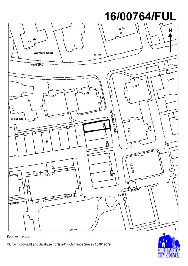
PUBLIC INFORMATION
Role of the Planning and Rights of Way Smoking policy – The Council operates a no-
Panel smoking policy in all civic buildings
The Panel deals with various planning and Mobile Telephones:- Please switch your mobile
rights of way functions. It determines telephones to silent whilst in the meeting
planning applications and is consulted on
proposals for the draft development plan. Use of Social Media:- The Council supports the
video or audio recording of meetings open to the
Public Representations public, for either live or subsequent broadcast.
Procedure / Public Representations However, if, in the Chair’s opinion, a person
At the discretion of the Chair, members of the filming or recording a meeting or taking
public may address the meeting on any photographs is interrupting proceedings or
report included on the agenda in which they causing a disturbance, under the Council’s
have a relevant interest. Any member of the Standing Orders the person can be ordered to
public wishing to address the meeting should stop their activity, or to leave the meeting.
advise the Democratic Support Officer (DSO) By entering the meeting room you are consenting
whose contact details are on the front sheet to being recorded and to the use of those images
of the agenda. and recordings for broadcasting and or/training
purposes. The meeting may be recorded by the
press or members of the public.
Any person or organisation filming, recording or
broadcasting any meeting of the Council is
responsible for any claims or other liability
resulting from them doing so.
Details of the Council’s Guidance on the
recording of meetings is available on the
Council’s website.
Southampton City Council’s Priorities Fire Procedure – In the event of a fire or other
Jobs for local people emergency a continuous alarm will sound and
Prevention and early intervention you will be advised by Council officers what
Protecting vulnerable people action to take.
Affordable housing
Services for all Access – Access is available for disabled
City pride people. Please contact the Democratic Support
A sustainable Council Officer who will help to make any necessary
arrangements.
Dates of Meetings: Municipal Year 2016/17
2016 2017
7 June 13 September 10 January
21 June 4 October 21 February
12 July 25 October 14 March
2 August 15 November 4 April
23 August 6 December 25 April
CONDUCT OF MEETING

Terms of Reference                            Business to be discussed

The terms of reference of the Planning        Only those items listed on the attached agenda
and Rights of Way Panel are contained in      may be considered at this meeting.
Part 3 (Schedule 2) of the Council’s
Constitution

Rules of Procedure                            Quorum

The meeting is governed by the Council        The minimum number of appointed Members
Procedure Rules as set out in Part 4 of       required to be in attendance to hold the
the Constitution.                             meeting is 3.

                               DISCLOSURE OF INTERESTS
Members are required to disclose, in accordance with the Members’ Code of Conduct, both
the existence and nature of any “Disclosable Pecuniary Interest” or “Other Interest” they
may have in relation to matters for consideration on this Agenda.
                         DISCLOSABLE PECUNIARY INTERESTS
A Member must regard himself or herself as having a Disclosable Pecuniary Interest in any
matter that they or their spouse, partner, a person they are living with as husband or wife,
or a person with whom they are living as if they were a civil partner in relation to:
(i) Any employment, office, trade, profession or vocation carried on for profit or gain.
(ii) Sponsorship:
Any payment or provision of any other financial benefit (other than from Southampton City
Council) made or provided within the relevant period in respect of any expense incurred by
you in carrying out duties as a member, or towards your election expenses. This includes
any payment or financial benefit from a trade union within the meaning of the Trade Union
and Labour Relations (Consolidation) Act 1992.
(iii) Any contract which is made between you / your spouse etc (or a body in which the you /
your spouse etc has a beneficial interest) and Southampton City Council under which
goods or services are to be provided or works are to be executed, and which has not been
fully discharged.
(iv) Any beneficial interest in land which is within the area of Southampton.
(v) Any license (held alone or jointly with others) to occupy land in the area of Southampton
for a month or longer.
(vi) Any tenancy where (to your knowledge) the landlord is Southampton City Council and
the tenant is a body in which you / your spouse etc has a beneficial interests.
(vii) Any beneficial interest in securities of a body where that body (to your knowledge) has
a place of business or land in the area of Southampton, and either:
      a) the total nominal value fo the securities exceeds £25,000 or one hundredth of the
         total issued share capital of that body, or
      b) if the share capital of that body is of more than one class, the total nominal value of
         the shares of any one class in which you / your spouse etc has a beneficial interest
         that exceeds one hundredth of the total issued share capital of that class.
Other Interests
A Member must regard himself or herself as having an, ‘Other Interest’ in any membership
of, or occupation of a position of general control or management in:
Any body to which they have been appointed or nominated by Southampton City Council
Any public authority or body exercising functions of a public nature
Any body directed to charitable purposes
Any body whose principal purpose includes the influence of public opinion or policy
Principles of Decision Making
All decisions of the Council will be made in accordance with the following principles:-
proportionality (i.e. the action must be proportionate to the desired outcome);
due consultation and the taking of professional advice from officers;
respect for human rights;
a presumption in favour of openness, accountability and transparency;
setting out what options have been considered;
setting out reasons for the decision; and
clarity of aims and desired outcomes.
In exercising discretion, the decision maker must:
understand the law that regulates the decision making power and gives effect to it. The
decision-maker must direct itself properly in law;
take into account all relevant matters (those matters which the law requires the authority
as a matter of legal obligation to take into account);
leave out of account irrelevant considerations;
act for a proper purpose, exercising its powers for the public good;
not reach a decision which no authority acting reasonably could reach, (also known as
the “rationality” or “taking leave of your senses” principle);
comply with the rule that local government finance is to be conducted on an annual
basis. Save to the extent authorised by Parliament, ‘live now, pay later’ and forward
funding are unlawful; and
act with procedural propriety in accordance with the rules of fairness.AGENDA
1 APOLOGIES AND CHANGES IN PANEL MEMBERSHIP (IF ANY)
To note any changes in membership of the Panel made in accordance with Council
Procedure Rule 4.3.
2 DISCLOSURE OF PERSONAL AND PECUNIARY INTERESTS
In accordance with the Localism Act 2011, and the Council’s Code of Conduct,
Members to disclose any personal or pecuniary interests in any matter included on the
agenda for this meeting.
3 STATEMENT FROM THE CHAIR
CONSIDERATION OF PLANNING APPLICATIONS
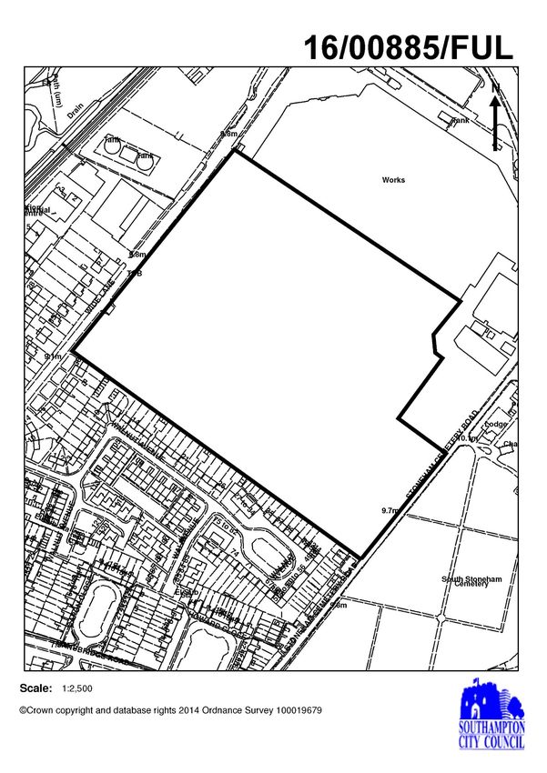
4 PLANNING APPLICATION - 16/00885/FUL- FORMER FORD MOTOR CO, WIDE
LANE
(Pages 5 - 46)
Report of the Service Lead – Infrastructure, Planning and Development recommending
delegated authority be granted in respect of an application for a proposed
development at the above address, attached.
5 PLANNING APPLICATION- 16/00764/FUL - 65 SUTTONES PLACE
(Pages 47 - 70)
Report of the Service Lead – Planning, Infrastructure and Development recommending
that conditional authority be granted in respect of an application for a proposed
development at the above address, attached.
Monday, 26 September 2016 SERVICE DIRECTOR, LEGAL AND GOVERNANCEThis page is intentionally left blank
Agenda Annex

                INDEX OF PLANNING APPLICATIONS FOR DECISION
  DATE: 4th October 2016 - 6pm Conference Rooms 3 and 4, 1st Floor, Civic Centre

Main Agenda     Officer     Recommendation          PSA      Application Number / Site
Item Number                                                           Address

      1           SH               DEL               15     16/00885/FUL
                                                            Former Ford Motor Co, Wide
                                                            Lane

      2           AC               CAP                5     16/00764/FUL
                                                            65 Suttones Place

PSA – Public Speaking Allowance (mins); CAP - Approve with Conditions: DEL - Delegate to
Officers: PER - Approve without Conditions: REF – Refusal: TCON – Temporary Consent:
NOBJ – No objection

SH – Stephen Harrison
AC – Anna Coombes

                                       Page 1
Southampton City Council - Planning and Rights of Way Panel
Report of Planning & Development Manager
Local Government (Access to Information) Act 1985
Index of Documents referred to in the preparation of reports on Planning
Applications:
Background Papers
1. Documents specifically related to the application
(a) Application forms, plans, supporting documents, reports and covering
letters
(b) Relevant planning history
(c) Response to consultation requests
(d) Representations made by interested parties
2. Statutory Plans
(a) Hampshire, Portsmouth, Southampton and New Forest National Park
Minerals and Waste Plan (Adopted 2013)
(b) Amended City of Southampton Local Plan Review (Adopted March
2015)
(c) Local Transport Plan 2006 – 2011 (June 2006)
(d) Amended City of Southampton Local Development Framework – Core
Strategy (inc. Partial Review) (adopted March 2015)
(e) Adopted City Centre Action Plan (2015)
(f) Community Infrastructure Levy Charging Schedule (2013)
(g) Bassett Neighbourhood Plan (Adopted 2016)
3. Statutory Plans in Preparation
4. Policies and Briefs published and adopted by Southampton City Council
(a) Old Town Development Strategy (2004)
(b) Public Art Strategy
(c) North South Spine Strategy (2004)
(d) Southampton City Centre Development Design Guide (2004)
(e) Streetscape Manual (2005)
(f) Residential Design Guide (2006)
(g) Developer Contributions SPD (September 2013)
(h) Greening the City - (Shoreburs; Lordsdale; Weston; Rollesbrook
Valley; Bassett Wood and Lordswood Greenways) - 1985-1995.
(i) Women in the Planned Environment (1994)
(j) Advertisement Control Brief and Strategy (1991)
(k) Biodiversity Action Plan (2009)
(l) Economic Development Strategy (1996)
(m) Test Lane (1984)
(n) Itchen Valley Strategy (1993)
Page 2(o) Portswood Residents’ Gardens Conservation Area Character Appraisal
(1999)
(p) Land between Aldermoor Road and Worston Road Development Brief
Character Appraisal(1997)
(q) The Bevois Corridor Urban Design Framework (1998)
(r) Southampton City Centre Urban Design Strategy (2000)
(s) St Mary’s Place Development Brief (2001)
(t) Ascupart Street Development Brief (2001)
(u) Woolston Riverside Development Brief (2004)
(v) West Quay Phase 3 Development Brief (2001)
(w) Northern Above Bar Development Brief (2002)
(x) Design Guidance for the Uplands Estate (Highfield) Conservation Area
(1993)
(y) Design Guidance for the Ethelburt Avenue (Bassett Green Estate)
Conservation Area (1993)
(z) Canute Road Conservation Area Character Appraisal (1996)
(aa) The Avenue Conservation Area Character Appraisal (1997)
(bb) St James Road Conservation Area Character Appraisal (1996)
(cc) Banister Park Character Appraisal (1991)*
(dd) Bassett Avenue Character Appraisal (1982)*
(ee) Howard Road Character Appraisal (1991) *
(ff) Lower Freemantle Character Appraisal (1981) *
(gg) Mid Freemantle Character Appraisal (1982)*
(hh) Westridge Road Character Appraisal (1989) *
(ii) Westwood Park Character Appraisal (1981) *
(jj) Cranbury Place Character Appraisal (1988) *
(kk) Carlton Crescent Character Appraisal (1988) *
(ll) Old Town Conservation Area Character Appraisal (1974) *
(mm) Oxford Street Conservation Area Character Appraisal (1982) *
(nn) Bassett Green Village Character Appraisal (1987)
(oo) Old Woolston and St Annes Road Character Appraisal (1988)
(pp) Northam Road Area Improvement Strategy (1987)*
(qq) Houses in Multiple Occupation (2012)
(rr) Vyse Lane/ 58 French Street (1990)*
(ss) Tauntons College Highfield Road Development Guidelines (1993)*
(tt) Old Woolston Development Control Brief (1974)*
(uu) City Centre Characterisation Appraisal (2009)
(vv) Parking standards (2011)
* NB – Policies in these documents superseded by the Residential Design
Guide (September 2006, page 10), albeit character appraisal sections still to
be had regard to.
5. Documents relating to Highways and Traffic
(a) Hampshire C.C. - Movement and Access in Residential Areas
(b) Hampshire C.C. - Safety Audit Handbook
(c) Southampton C.C. - Cycling Plan (June 2000)
(d) Southampton C.C. - Access for All (March 1995)
Page 3(e) Institute of Highways and Transportation - Transport in the Urban
Environment
(f) I.H.T. - Traffic Impact Assessment Guidelines
(g) Freight Transport Association - Design for deliveries
(h) DETR Traffic Advisory Leaflets (various)
6. Government Policy Planning Advice
(a) National Planning Policy Framework (27.3.2012)
(b) National Planning Policy Guidance Suite
7. Other Published Documents
(a) Planning for Daylight and Sunlight - DOE
(b) Coast and Countryside Conservation Policy - HCC
(c) The influence of trees on house foundations in clay soils - BREDK
(d) Survey and Analysis - Landscape and Development HCC
(e) Root Damage to Trees - siting of dwellings and special precautions –
Practice Note 3 NHDC
(f) Shopping Policies in South Hampshire - HCC
(g) Buildings at Risk Register SCC (1998)
(h) Southampton City Safety Audit (1998)
(i) Urban Capacity Study 2005 – 2011 (March 2006)
(j) Strategic Housing Land Availability Assessment (March 2013)
Page 4Agenda Item 4
Planning, Transport & Sustainability Division
Planning and Rights of Way Panel 4th October 2016
Planning Application Report of the Planning and Development Manager
Application address:
Former Ford Motor Co, Wide Lane, Southampton
Proposed development:
Development to provide new industrial and warehouse buildings for business use (class
B1c), industry (class B2) and storage/distribution (class B8) with landscaping, tree planting
and new boundary treatment, new car parking and service areas, new vehicular access
from Wide Lane and associated works - description amended following receipt of amended
plans showing the removal of a proposed footpath through the site to Stoneham Cemetery
Road and an increase to the acoustic fence between unit 1 and 4 along the southern
boundary from 2.1 to 4 metres.
Application 16/00885/FUL Application type FUL
number
Case officer Stephen Harrison Public speaking 15 minutes
time
Last date for 19.08.16 (PPA) Ward Swaythling
determination:
Reason for Panel Request by Ward Ward Councillors Cllr Mintoff
Referral: Member and five or Cllr Painton
more letters of Cllr Vassiliou
objection have been
received and the
scheme is of strategic
importance to the
economic growth of
the city.
Referred to Panel Cllr Painton Reason: Concerns raised
by: about pedestrian
links through to
Stoneham Cemetery
Road
Applicant: Mountpark Logistics Agent: Oxalis Planning
Attn. Mr Steve Harley
Recommendation Delegate to Planning and Development Manager to grant planning
Summary permission subject to criteria listed in report
Community No
Infrastructure
Levy Liable
Page 5 1Reason for granting Permission
The development is acceptable taking into account the policies and proposals of the
Development Plan as set out below. The Council has considered the proposal in the context
of the site allocation for industrial and warehousing development as set out in the
Development Plan, and the importance of the additional employment to be created by this
development. The development would have an impact on the surrounding area in terms of
character and appearance, traffic and noise but that this impact can be mitigated by Section
106 obligations, and planning conditions, and has been assessed in the context of the site’s
former historic use for significant manufacturing. The scheme has been amended during the
application process to remove the pedestrian link to Stoneham Cemetery Road. Other
material considerations have been considered, as set out in the report to the Planning and
Rights of Way Panel (04.10.16), and are not judged to have sufficient weight to justify a
refusal of the application. The scheme is therefore judged to be in accordance with the
development plan as required by Section 38(6) of the Planning and Compulsory Purchase
Act 2004 and planning permission should therefore be granted. In reaching this decision
the Local Planning Authority offered a pre-application planning service and has sought to
work with the applicant in a positive and proactive manner as required by paragraphs 186-
187 of the National Planning Policy Framework (2012).
Policies - SDP1, SDP4, SDP5, SDP7, SDP9, SDP10, SDP13, SDP14, SDP15, SDP16,
SDP17, SDP19, SDP22, NE4, NE5, TI2, HE6 and REI9(ii) of the City of Southampton Local
Plan Review (LPR - as amended 2015) and CS6, CS7, CS13, CS18, CS19, CS20, CS22,
CS23, CS24 and CS25 of the Local Development Framework (LDF) Core Strategy
Development Plan Document (as amended 2015) and guidance in the NPPF (2012).
Appendix attached
1 Development Plan Policies 2 Hampshire County Council Response
Recommendation in Full
1. Delegate to the Planning and Development Manager to grant conditional planning
permission subject to the completion of a S.106 Legal Agreement to secure:
i. Either a s.278 Agreement to undertake agreed works within the highway or a financial
contribution and other highway obligations, including Traffic Regulation Orders,
where necessary, towards site specific transport improvements in the vicinity of the
site in line with policies SDP4 and TI2 of the City of Southampton Local Plan Review
(as amended 2015), Policies CS18 and CS25 of the adopted LDF Core Strategy (as
amended 2015) and the adopted SPD relating to Planning Obligations (September
2013); to include replacement bus stops along Wide Lane with Real Time Information
(RTI), the introduction of a dedicated cycle lane along Wide Lane (space permitting)
and the ability to introduce a signalised junction into the site should future
assessments demonstrate that it would be necessary, and the new access
arrangement with signage, as shown on plan ref: 15/263/004 Rev A, to discourage
GHVs from turning left out of the site;
ii. An off-site contribution towards bridge improvement works to secure access from the
site to Junction 5 of the M27 as requested by Hampshire County Council and the
Hampshire Chamber of Commerce, in line with policies SDP4 and TI2 of the City of
Southampton Local Plan Review (as amended 2015), Policies CS18 and CS25 of the
adopted LDF Core Strategy (as amended 2015) and the adopted SPD relating to
Planning Obligations (September 2013);
Page 6 2iii. Submission of a highway condition survey to ensure any damage to the adjacent
highway network attributable to the build process is repaired by the developer;
iv. Submission of a Training & Employment Management Plan committing to adopting
local labour and employment initiatives, both during and post construction, in
accordance with Policies CS24 and CS25 of the Local Development Framework Core
Strategy Development Plan Document - Adopted Version (as amended 2015) and
the adopted SPD relating to Planning Obligations (September 2013);
v. The submission, approval and implementation of a Carbon Management Plan setting
out how carbon neutrality will be achieved and/or how remaining carbon emissions
from the development will be mitigated in accordance with Policy CS20 of the Core
Strategy and the Planning Obligations SPD (September 2013);
vi. Provision of public art in accordance with the Council's Public Art Strategy to reflect
the site’s importance, historically, to UK manufacturing;
vii. Submission and implementation of a Construction Traffic Management Plan;
viii. Submission and implementation of an Operational Phase Lorry Routing Agreement
to limit HGV traffic turning left out of the site; and
ix. Submission and implementation of a Staff Travel Plan.
2. In the event that the legal agreement is not completed within two months of the Panel
the Planning and Development Manager be authorised to refuse permission following
consultation with the Chair of the Planning and Rights of Way Panel on the ground of
failure to secure the provisions of the Section 106 Legal Agreement.
3. That the Planning and Development Manager be given delegated powers to add, vary
and/or delete relevant parts of the Section 106 agreement and/or conditions as
necessary. In the event that the scheme’s viability is tested prior to planning
permission being issued and, following an independent assessment of the figures, it
is no longer viable to provide the full package of measures set out above then a report
will be bought back to the Planning and Rights of Way Panel for further consideration
of the planning application.
1.0 The site and its context
1.1 The application site is some 7.6 hectares in area, and is situated on the eastern side
of Wide Lane. The application site forms part of the former Ford factory site, which
itself has a significant history of manufacturing having been central to the
manufacturing of aircraft components and parts during the Second World War.
Following the War the site evolved and grew into the manufacture of vehicle chassis
and eventually the Ford Transit van before its closure in 2013.
1.2 The application site is bounded to the east by Stoneham Cemetery Road, to the
north by the retained factory buildings (in separate land ownership), the M27 and
Southampton Airport beyond, to the west by Wide Lane and the Southampton to
London Waterloo railway line, and to the south by the back gardens of residential
neighbours fronting Walnut Avenue. The application site is currently a cleared site
with demolition of part of the former Ford factory having taking place to slab level.
There is mature tree planting to the site’s eastern, western and southern boundaries,
Page 7 3and the site is designated in the Local Plan Review (LPR) for light or general
industrial (Classes B1c and B2), research and development (Class B1b), storage or
distribution (Class B8) and ancillary office use (LPR Policy REI9(ii) refers). The
application site is close to the administrative boundary of the city with Eastleigh
Borough Council.
2.0 Proposal
2.1 The application involves developing this currently open site with four
business/storage and distribution buildings to provide a total of 35,371 sq.m
square metres of floorspace (Gross External). This is a speculative development
with no end user(s) currently reported. The largest of the four buildings (Unit 1)
would run along the southern site boundary for 160 metres and would provide
12,262 square metres of floorspace. Unit 2 in the northern part of the site, would
provide 8,962 sq.m. Unit 3 sits adjacent Unit 2 and would provide approximately
5,606 sq.m. Unit 4 completes the development, has a floorspace of 8,514sq.m,
and also sits alongside Unit 1 on the site’s southern boundary. It has a length of
110 metres. It is separated from Unit 1 by car parking and a 4m high acoustic
fence. Ancillary office space is also proposed to serve the development.
2.2 The development seeks flexibility in terms of land use to enable the buildings to
operate for either manufacturing and/or industry (Use Class B1c/B2 – 7am-7pm)
or storage and distribution (Use Class B8). The latter would potentially be on a
24 hour/day basis as was the former Ford factory. Such flexibility is not
uncommon for this type of speculative development and details of late night
activity can be secured with the attached planning conditions.
2.3 Vehicular access would be from a new ‘T’ junction onto Wide Lane, with scope in
the future for this junction to be signalised in the event that the development’s
traffic generation is higher than currently anticipated. 4 trees including a Field
Maple, 2 Willows and a Silver Birch will be felled to accommodate this access. A
total of 372 car parking spaces would be provided for the four units (assuming a
B8 operator) with scope for increasing the car parking to 567 should the levels of
B8 reduce to 50%, with the hardstanding reallocated from lorry parking and turning
space to staff car parking. Plans have been submitted to show alternative layouts
for all buildings.
2.4 The proposed external materials will be a mixture of horizontal cladding panels,
dark rainscreen cladding and extensive areas of glazing serving the office uses.
Officers are still in dialogue with the developers to ensure that the cladding along
the site’s southern boundary (to the rear of the existing residential neighbours) is
carefully chosen so that any glare from the sun is properly considered and
mitigated.
2.5 The height of the buildings will be 12 metres to the eaves and between 15.6 to
15.9 metres in height to the ridge. Between the two buildings on the southern
boundary, an acoustic fence would be built to a total height of approximately 4
metres. A 10 metre wide mature landscaped buffer is proposed upon a 1.2 metre
high bund filling the gap between the buildings and the common boundary
separating the development from the residential neighbours. A back to back
distance between buildings of between 23 and 30 metres is proposed. Existing
trees are to be retained except where the new access onto Wide Lane is
proposed.
Page 8 42.6 The application has been amended since it was initially submitted. The main
changes to the scheme involve the removal of a pedestrian link from Stoneham
Cemetery Road, and an increase in height to the acoustic fence between units 1
and 4. Objectors, and those neighbours most affected, have been re-notified of
these changes. If approved the applicants suggest that the development would
take 6-8 months to complete and it is hoped the buildings could be occupied by
late 2017.
3.0 Relevant Planning Policy
3.1 The Development Plan for Southampton currently comprises the “saved” policies
of the City of Southampton Local Plan Review (as amended 2015) and the City of
Southampton Core Strategy (as amended 2015). The most relevant policies to
these proposals are set out at Appendix 1. The application site is designated for
employment development under Policy REI9(ii) which reads as follows:
3.2 REI 9 Major Employment Sites
The major employment sites are defined on the Proposals Map and will be
safeguarded for employment use. Development proposals will be permitted as
follows:
(ii) Ford’s, Wide Lane for light or general industrial (Classes B1c and B2), research
and development (Class B1b), storage or distribution (Class B8) and ancillary
office use.
3.3 LDF Policy CS7 adds that:
In order to meet the South East Plan’s economic aims, as set out in Policy CS 6,
there is a strong need to safeguard employment sites. All existing employment sites
and allocations will be safeguarded for employment use…
3.4 Major developments are expected to meet high sustainable construction standards
in accordance with Core Strategy Policy CS20 and Local Plan “saved” Policy
SDP13. The applicant’s pre-assessment for this scheme predicts that the buildings
will achieve the Building Research Establishment’s Environmental Assessment
Method (BREEAM) ‘Excellent’ rating as required.
3.5 SCC Planning Policy – No objection
As a general principle, we support the proposal for redeveloping the site with B1c,
B2 and B8 uses as they would help towards maximise employment opportunities
on the site. It would therefore be compliant with criterion ii of Amended Local Plan
Review retained Policy REI 9 ‘Major Employment Sites’ and Core Strategy Policy
CS 6 ‘Economic Growth’ in contributing towards the delivery of industrial and
warehouse development.
3.6 It is noted from the submitted plans that ancillary office development (two storey
mezzanines) are proposed to be incorporated into 3 of the units. Core Strategy
Policy CS 8 ‘Office Location’ is therefore applicable whereby office development
greater than 750sq m gross will be directed towards the city, town or district centres
in line with Government Guidance. It is further noted in paragraph 4.6.13 of the
policy background / justification text within the Core Strategy that where office
development is part of an industrial or research / development operation of a similar
or larger scale belonging to the same company on the same site, the potential need
for co-locating the offices with this wider operation will be considered. Therefore, it
Page 9 5must be clear that the proposed ancillary offices would be ancillary and integral to
a wider operation of the units.
3.7 In order to maximise the benefits of the proposal, it will be necessary to take
account of Core Strategy Policy CS 24 ‘Access to Jobs’ whereby measures will be
sought from major employment generating development to promote access to jobs
it creates amongst those residents of the city who can have difficulty returning to
the labour market. This will be particularly relevant to the proposal in that it would
provide industrial development significantly greater than 1,700 square metres,
warehouse development significantly greater than 4,000 square metres and well
over 50 full time equivalent jobs (i.e. 900 – 1,000 full-time equivalent employees).
3.8 In terms of our existing planning policies within the Amended Local Plan Review
(2015) and Amended Core Strategy (2015), we do not have anything which
specifically requires one type of employment use (i.e. B1-8) over another. It would
be preferable if the proposal was to include a mix of B1c, B2 and B8 uses as this
would see a higher job density created. However, it is also noted that B8 uses can
provide skilled logistical jobs and provide potential linkages to Port related activities
and with this in mind, we can be flexible on the overall mix of uses proposed if this
can be demonstrated by the applicant/agent. Such provision would also help
towards delivering 97,000sq.m’s of industrial and warehouse development (of
which there is no distinction between the two) in the city between 2006 and 2026
as set out in the Adopted Core Strategy (2015). The recently published PUSH
Spatial Position Statement (June 2016) shows a planned increase of 74,000sq.m
of B-class employment floorspace over the 2011-2034 period whereby the proposal
would also help towards meeting this target which is based on latest evidence.
3.9 The National Planning Policy Framework (NPPF) came into force on 27th March
2012 and replaces the previous set of national planning policy guidance notes and
statements. The Council has reviewed the Core Strategy to ensure that it is in
compliance with the NPPF and are satisfied that the vast majority of policies accord
with the aims of the NPPF and therefore retain their full material weight for decision
making purposes, unless otherwise indicated.
4.0 Relevant Planning History
4.1 The site’s physical development has evolved since the Second World War and has
been used for manufacturing since before the current planning system. The
Council’s planning history records numerous additions to the site throughout this
period although none of this planning history is directly relevant to the current
application.
4.2 Part of the site to the north of this application site has been retained as a vehicle
repair centre and export distribution centre (LPA ref: 14/00028/FUL), but the
demolition of the other buildings has commenced, and is largely complete for this
part of the wider site. These works were approved through the demolition ‘prior
approval’ process (LPA ref: 14/01825/DPA, 15/00114/DPA and 15/01001/DPA).
4.3 The Panel will be aware that the Council has determined other planning
applications for similar developments across the City and, by way of comparison,
these can be summarised as follows:
Page 10 64.4 Lidl Distribution - 12/00106/FUL
Demolition of six residential properties and erection of a Regional Distribution
Centre (42,820 square metres gross floor space - Class B8), 186 associated car
parking spaces, HGV hardstanding, two sprinkler tanks and pump room and new
peripheral landscaping. Proposal includes the stopping up of Lower Redbridge
Lane and diversion of a public right of way.
Measures 311 metres in length and 124 metres in width.
The height of the building steps down from north to south in three elements:
The northern section has an eaves height of 16.66m and an overall parapet height
of 18.33m; the central section has an eaves height of 14.22m and a parapet height
of 15.89m; the lower and smallest section of the building at the southern end of the
site has an eaves height of 11m and a parapet height of 13.10m.
4.5 NXP/UPS – 12/00975/OUT
Outline application for re-development of the site to provide up to 20,360 square
metres of employment floorspace (Classes B1(a) / B1(c) / B2 / B8) with ancillary
offices, service areas, estate roads, landscaping and cycle/car parking.
The Parameters Plan (30348/FE/120) confirms that any subsequent reserved
matters proposal will be restricted by the following:
Building Height - between 7.5 and 15.5m
Building Width - between 10 and 150m
4.6 UPS - 13/00206/REM
Application for reserved matters approval (access, appearance, landscaping,
layout and scale) pursuant to outline planning permission dated 30 January 2013
(reference 12/00975/OUT) for redevelopment of the site. This application is for part
of the site to provide an industrial/warehouse unit (Classes B1c, B2 and B8 - total
floorspace of 8600 square metres) with access from Second Avenue and Allington
Road, servicing areas and car parking.
Seeking reserved matters approval for Phase 1 of the site’s redevelopment. It
comprises 8,600sq.m of B1c, B2 and B8 floorspace on 2.24 hectares of land. The
proposals show a large distribution depot for UPS (comprising 7,520sq.m of B8
floorspace with 722sq.m of ancillary office and a Vehicle Maintenance Unit with
358sq.m). A modern warehouse building is proposed measuring 114m wide and
12.4m tall.
4.7 Selco - 14/01273/REM
Application for reserved matters approval (Layout, Access, Appearance, Scale, and
Landscaping) pursuant to outline permission reference 12/00975/OUT for
redevelopment for industrial and warehousing use. Application for discharge of
conditions 3 (car parking), 6 (drainage), 16 (refuse and cycle storage) and 18 (tree
protection) of the outline permission
4.8 Test Lane - 14/01911/FUL
Redevelopment of the site to provide 19,132 square metres of employment
floorspace in three buildings (Units 1 and 3 to be storage and distribution use (Class
B8), Unit 2 to be Business use (Class B1c) and/or storage and distribution use
(Class B8)) with an area of open space, associated landscaping, servicing areas
and car parking with vehicular access from Test Lane (amended description
following alterations to the planning application).
Page 11 719,132 square metres of floorspace. The largest of the three buildings (Unit 1)
10,860 square metres of storage and distribution unit (Class B8). Unit 2 would
provide approximately 3,630 sq.m floorspace for either Business Use - light
industrial (Class B1 c) or Storage and Distribution Use (Class B8). Unit 3 would
provide approximately 4,640 sq.m floorspace (Class B8). The development would
potentially operate on a 24 hour basis. The height of the buildings will be 12 metres
to the eaves and 14.3 metres to the top of the roof. Between the two buildings on
the southern boundary, an acoustic fence would be built above an earth bund to a
total height of approximately 12 metres.
5.0 Consultation Responses and Notification Representations
5.1 In accordance with the Council’s Statement of Community Involvement, and best
practice, the applicants held their own pre-application public consultation event on
8th April 2016 at which 50 local residents attended.
5.2 Following the receipt of the planning application a publicity exercise in line with
department procedures was undertaken which included notifying adjoining and
nearby landowners (some 440 letters sent), placing a press advertisement
(03.06.16) and erecting a site notice (03.06.16). A re-notification was also
undertaken following a change to the acoustic fence and linkages into Stoneham
Cemetery Road. At the time of writing the report 7 representations have been
received from surrounding residents, including a Panel referral request from Ward
Cllr Painton due to the proposed pedestrian access into Stoneham Cemetery Road.
The following is a summary of the points raised:
5.3 The height of the proposed buildings and their proximity to the properties in
Walnut Grove will result in late night disturbance, loss of light, overlooking,
overshadowing and they are too close. Suggests noisy activity is restricted to
7:30am-6pm Monday to Saturday.
Response
The proposed development introduces taller development closer to existing
residents as described. A 24 hour operation is also sought. Whilst every resident’s
comments are important to the planning determination of this case it is worth noting
that only 1 resident living in Walnut Grove has objected to the application and their
concerns are addressed more fully in the ‘Planning Considerations’ section of this
report.
5.4 There is a lack of parking on site and measures should be put in place to ensure
workers will not park in local streets.
Response
The proposed development will be served by between 372 and 567 car parking
spaces depending upon the end mix of uses. These totals are based upon the
Council’s maximum standards (of 1 space per 90sq.m (B8), 1 space per 45sq.m
(B2 and B1c)) and, as such, the car parking offer accords with the development
plan standards. In the event that all four buildings are taken for storage and
distribution, which is a possibility given the excellent transport links to the motorway
network and Port of Southampton, the maximum number of spaces required would
be 393 spaces based on these standards. A significant amount of on-site parking
is proposed and it is not envisaged that any overspill will occur; the Council could,
however, introduce Controlled Parking Zones into the nearby streets following
consultation with affected residents. This has not been requested by the Council’s
Page 12 8Highways Team at the time of writing and does not currently form part of the
recommendation.
5.5 The railway bridge at the top of Wide Lane is very narrow and has a sharp bend
that cause problems for HGVs. A new railway crossing is needed for access to
the M27 to avoid congestion caused by this development.
Response
There is ongoing discussion with Hampshire County Council as to whether or not
the development should contribute towards improvements to the existing bridge
over the railway. A s.106 financial contribution can be secured if necessary. There
are no plans for a new bridge link and any expectation that this development should
provide this infrastructure would render the whole development unviable. In the
context of the previous use it would also be unreasonable to expect this
development to make such a significant contribution to improved infrastructure in
the locality.
5.6 The proposed pedestrian link from the site into Stoneham Cemetery Road will
compromise security, peace and will exacerbate parking issues as workers park
off-site and walk through.
Response
In design and highway terms improving linkages into the site from the east is seen
positively. However, following these local concerns, and an objection from
Hampshire Constabulary, the applicants have agreed to remove this link. Objectors
have been re-notified of the change.
5.7 Construction traffic will add to congestion
Response
No more so than any other major development site, and measures are in place to
restrict construction hours and secure a management plan (including construction
vehicle routing to ensure vehicles avoid residential areas).
5.8 The development will devalue my property
Response
This statement is not supported by any evidence. In any event, the effect of
development upon neighbouring property values is not a material consideration to
which weight should be afforded in deciding on this planning application.
Consultation Responses
5.9 SCC Highways – Further discussion needed
The submitted Transport Assessment (as updated) attempts to identify the likely
impacts that 35,371sq.m of employment uses could have on the local and strategic
highway network. The likely trip generation, particularly by HGVs, across a 24
hour/day operation have not, however, in our opinion been properly presented and
instead still focus upon peak hours thereby reducing the true impacts. Their
assessment of the Ford traffic as a comparison is flawed and doesn’t account for
the shift pattern operated by Fords, which was a 3 shift system for factory workers,
6-2, 2-10, and 10-6. Office workers were 7.30-4.30. Similarly, as far as HGV
movements are concerned, again, I think the figures are misleading; Fords would
not have run HGVs at peak times as they did a great deal of HGV movements at
night to avoid congestion on the network. Further work is still, therefore, required.
That said, the previous factory use provided some 100,000sq.m across a 24 hour
Page 13 95.10 operation and against this baseline position the likely net trip generation is unlikely
to be significant enough that it cannot be mitigated through off-site contributions
and works. Further discussion with the applicant will be needed before the s.106
contributions can be agreed and the permission released, although agreement has
been reached on the necessary improvements to public transport and cycle ways
along Wide Lane. The applicants have also agreed that the proposed access can
be future-proofed with payment made to the City Council so that traffic lights can
be installed following occupation of the development; should their trip generation
analysis prove to be an underestimate and vehicles are queuing within the
development struggling to turn right out of the site towards the motorway. On this
basis the development can proceed as the new access has been designed to
accommodate 35,371sq.m of new development. The car and cycle parking
provision shown is flexible to the final use and the overall numbers are compliant
with our adopted maximum standards. Planning conditions, alongside the s.106
legal agreement, are recommended and controls are needed to ensure that HGVs
associated with both the construction and operational phases use Wide Lane to
gain access to the M27 rather than using the more residential streets to the south
of the application site.
Note: These comments were made prior to the receipt of the data presented in the
5.11 table at paragraph 6.4.4 of this report. The trip generation discussions are ongoing
and an update will be provided at the Panel meeting. The comments from
Hampshire County Council (set out at Appendix 2 and summarised below) are also
relevant in these negotiations.
5.12 SCC Design – No objection
I’m generally happy with what has been submitted, but with regard to the landscape
proposals I’ve attached a marked up plan indicating where I would like to see some
additional tree planting.
5.13 The green acoustic fence should arrive pre-grown for instant/immediate effect and
I note from the submitted drawings this won’t be the case. I feel that this is a critical
feature of the landscape and should have instant impact, rather than having to wait
5-10 years for the full effect.
5.14 Note: Amended plans have been received to meet these suggested changes.
5.15 Given the critical importance of establishing the southern boundary in particular, we
do need to see how they propose to ensure the establishment and ongoing
management of the estate landscape. I am concerned about the establishment of
the southern boundary as it will be quite a hostile environment for new plants,
especially the large tree material and it will be important to understand how the
scheme in particular is to be irrigated. It will be vital that we have a clear
maintenance specification and ensure that we are notified upon completion to
ensure that we can check what has been specified actually gets planted and in the
correct quantities.
5.16 SCC Sustainability Team – No objection – Initial concerns addressed
The original BREEAM document showed a 5% improvement only, however if they
are committing to the passive approach (as outlined) showing a 40% improvement
on Target Emission Rates then no objection is raised subject to planning conditions.
5.17 SCC Environmental Health – No objection following amendments
Page 14 10i) Air Quality
I agree with the recommendations of the AQ report. An informative that
infrastructure should be built into the development for charging points for electric
cars to be installed at a later date is needed.
5.18 Note: the nearest Air Quality Management Area is 400m north of the site located
within Eastleigh Borough Council’s administrative boundary.
5.19 ii) Noise
5.20 Please would you find out from the applicant if the external noise levels from lorries
includes refrigerated lorries, or are these excluded? If they are included, or to be
included, I will want a condition for the refrigeration units to be plugged into the
mains electrical supply while on site to reduce the use of diesel motors for the
refrigeration unit, but to use electric motors. The noise calculations need to be
recalculated if the refrigerated lorries have not been included.
5.21 The BS 4142 uses the LL9090 from all three monitoring points and aggregates
them for the whole of the site. I believe the L90 should be calculated for each
receiving location, particularly for Walnut Avenue, and the BS 4142 recalculated.
The barrier at 2.5 metres between buildings 1 and 4 seems to me to be too low in
this location, with noise being funnelled down the gap between the two buildings
from the yard and parking area. It doesn’t seem to me to fit with our discussions to
move the buildings close to the edge of the site to act as a noise barrier, to allow
this gap to remain for noise to escape through.
5.22 The noise from plant needs to recognise the design level for plant in Para 2.88
which states, ‘Developments which in themselves are not normally considered to
be noise generating, increasingly incorporate air handling fan or ventilation plant
for heating and cooling. This type of plant can be a significant source of noise. To
ensure that these noise sources do not increase the existing background level, their
design noise emission specification should be designed at 10 decibels (A
weighting) (dB(A)) below pre-existing background levels. This specification has
regard to the prevention of a ‘creeping’ increase in background noise levels in the
city. BS 4142 is not the method for determining the level in this case
5.23 The suggested condition for internal noise seems to me to be unenforceable, the
building should be built with worst case in mind for the correct level of acoustic
insulation to be installed at the time of first construction.
5.24 Note: Following the change to the acoustic fence the Environmental Health Officer
has confirmed that there will be very little impact on the residents of Walnut Avenue
in noise terms.
5.25 SCC Environmental Health (Contaminated Land) – No objection
I am now satisfied that the site is suitable for its proposed use and will not require
any further investigation with respect to land contamination. There will be a
condition that requires the developer to be vigilant for evidence of unsuspected
contamination being revealed during ground works. If contamination is discovered
the Local Planning Authority must be notified and the contaminated land managed
appropriately. If no contamination is discovered by completion of the groundworks
the developer must notify the Local Planning Authority so that the condition can be
discharged in full. There will also be a condition that requires any soils imported
Page 15 11on to the site to be validated to show that they are suitable for use and not
contaminated. Conditions relating to imported soils and unsuspected
contamination are required although further investigation is now unnecessary.
5.26 SCC Ecology – No objection
The application site comprises a cleared site that was formerly a vehicle
manufacturing facility. The site is predominately hard-standing with small areas of
trees, shrubs and amenity grassland around the perimeter. As a consequence it
has low ecological value.
5.27 The proposed development is similar in nature to the previous use and I do not
believe that there will be any significant adverse ecological impacts. I am, however,
concerned about the possibility of extra lighting being introduced along the northern
section of Stoneham Cemetery Lane to facilitate the cycle and pedestrian access
(note: now removed). Stoneham Cemetery contains suitable foraging habitat for
bats however, no assessment has been made of bat foraging activity. As bats are
adversely affected by artificial illumination I would expect an assessment to be
made prior to the introduction of additional lighting.
5.28 I am supportive of the proposed living walls however, I would like to see the
inclusion of a wider range of plants including flowering species such as clematis,
summer jasmine and honeysuckle to provide habitat for pollinator species. I would
also prefer to see the native ivy, Hedera helix, which is on the Royal Horticultural
Society's Perfect for Pollinators list, used rather than Irish ivy which is not. I am
happy with the species selected for the proposed thicket, the indigenous hedgerow
and the wildflower grassland.
5.29 The ecological appraisal makes recommendations for a number of biodiversity
mitigation and enhancement measures which I would like to see implemented via
a planning condition.
5.30 SCC Archaeology – No objection
The application is supported, however I disagree with the assertions contained in
the Archaeological Desk Based Assessment (DBA) that 'any such [archaeological]
remains are only likely to survive in a truncated and/or highly fragmented state.'
This statement is based on the previous development history of the site supported
by a watching brief on engineering test pits carried out earlier this year. It should
be noted that these test pits were not positioned to establish the presence or
absence of archaeological remains, and would not comprise a sufficient sample to
be able to confidently predict either way.
5.31 It is clear that there has been extensive groundworks associated with the
construction and use of the factory (notably the WWII Air Raid shelters shown on
Arcadis fig 3 (Appendix 3 of the DBA), and further disturbance is shown in Arcadis
fig 4 - Drainage networks. It is also likely that there will have been some truncation
associated with the factory building, however it is clear from previous
archaeological work within the site (SOU 783) that there is sufficient potential for
significant archaeological remains to be present to warrant further archaeological
work.
The threat to archaeological deposits (and therefore the extent of archaeological
5.32 work that will be required) can be minimised primarily through the design of the
foundations. It is assumed that the proposed units will sit on deep pile foundations,
Page 16 12and it would be extremely helpful if a piling plan can be submitted to support the
application. This will enable the production of a mitigation strategy that may limit
the amount of archaeological work that will be required.
A formal archaeological evaluation should be commissioned, based on the
5.33 information contained within the piling plan and guided by the known below-ground
disturbance, to establish the nature, extent and significance of any surviving
archaeological deposits. This may need to be followed by a further stage of
archaeological intervention, which could range from a Watching Brief to targeted
archaeological excavation in areas of greatest threat. Note that, depending on their
state of preservation, the WWII air-raid shelters may be worthy of archaeological
recording as well. Conditions recommended.
Note: Following these comments the Written Scheme of Investigation has been
undertaken and once this report has been archived the archaeology of the site will
have been correctly dealt with
5.34 SCC Tree Team – No objection
5.35 SCC Flood Risk Officer – No Objection
The proposed surface water drainage strategy is through the use of geocellular
tanks (or similar) under car park areas and access roads to accommodate the 1 in
100 year rainfall event (+ 30% climate change allowance) which in accordance with
the technical standards provides a marked reduction in peak discharge to
greenfield runoff rates and no increase in volume of runoff due to the equivalent
existing and proposed impermeable surfaces on the site. The proposed drainage
strategy is based on the assumption that infiltration is not feasible but it is stated
that infiltration tests have yet to be undertaken to confirm this assumption. If
infiltration is found to be suitable the following information will need to be provided
in order to satisfy that an appropriate infiltration assessment has been undertaken
as part of the further site investigation work. Planning conditions are
recommended.
5.36 City of Southampton Society - Welcome in principle.
The road should be kept open during construction as it is an important access road
to the railway station and the M27. The very narrow and sharply turning bridge
near the railway station is very unsatisfactory for commercial vehicles. The access
on to the Mansbridge Road near the cemetery is less than satisfactory. The
Swaythling arch is heavily used and only alternatively one way. Access to and
egress from the site will need greatly improved roads in the vicinity, especially so
far as the M27 is concerned.
5.37 Hampshire Chamber of Commerce – Support
The Chamber was relieved to learn that employment use was to continue for this
industrial land in a prime strategic location near the motorway network with good
accessibility by bus, rail and cycle. They agreed that new units for a range of
industrial, distribution and business use align with the Solent LEP’s priorities for this
area and, at the same time, the planned improvements to the landscaping and
noise mitigation for the site will be good news for nearby residents.
5.38 The Chamber would like to see contributions from the development towards much
needed improvements for Wide Lane bridge over the railway to create better traffic
flows connecting to the M27 and M3. Such improvements should also look to
Page 17 13provide the missing link in the cycle network between Mansbridge and the Airport
and provide safety for pedestrians. The new tenants should also be encouraged to
operate travel plans for their staff that are monitored, in order to relieve any peak
hour traffic congestion which may arise with hours of work no longer mail y on a
shift basis
5.39 Southampton Airport – No objection
The scheme could conflict with aerodrome safeguarding criteria unless conditions
relating to the submission of a Bird Hazard Management Plan, an agreement before
the erection of cranes (operational and construction), the submission of a
Construction Management Plan, details of obstacle lights (operational and
construction) being agreed, and the submission of a lighting plan are not imposed
with these details secured.
5.40 Hampshire Constabulary – No objection following receipt of amended plans
The applicant has engaged with the Police regarding potential crime and disorder
issues and as a result has been provided with a detailed report giving a number of
recommendations concerning layout, physical security of buildings, lighting and
CCTV, which, if implemented, would increase security and safety measures of the
buildings and for staff and visitors. In general terms, therefore, the Police would
have no objection to this scheme, however, there are areas of concern which in our
considered opinion are not being addressed appropriately, and are of sufficient
concern to warrant an objection.
5.41 These concerns relate primarily to the proposed pedestrian/cycle route through the
development and linking into Stoneham Cemetery Road. It is recognised that
alternative transport routes can be useful within a travel plan but they should only
be provided in appropriate locations and not at the risk of creating a crime generator
or where the safety of its users is compromised. It is recognised within crime
prevention advice and in government guidance such as 'Safer Streets' that these
routes should be accommodated on streets and not be isolated or segregated from
other vehicular traffic, as being seen by other drivers, residents and other road
users affords a greater sense of security. The Stoneham Cemetery Road for all
but the first 180 metres is unadopted and on viewing it, it is clear it is highly
unsuitable for use by pedestrians and cyclists. It is a single tracked shared surface
(with vehicles visiting the cemetery) with numerous potholes and patched repairs,
it is completely unlit, poorly overlooked and the tree canopies in several places
create a very enclosed space. I disagree therefore with the claim made in the
Design & Access Statement Para 3.46 which states they have "clearly
demonstrated the site is highly sustainable in terms of its accessibility by walking
and cycling".
5.42 A further concern is that by creating this short cut to the development, Stoneham
Cemetery Road will become a car park for staff, thus increasing the risk of vehicle
crime and the safety of cyclists and pedestrians. This route is more likely to create
an unsafe route, particularly during darkness and all concerned should be mindful
of sanctioning a route which encourages users but which is a potential crime
generator and safety hazard. The concerns over this route are compounded by the
absence of highway lighting along the access road within the development, this
again increases the risk to pedestrians and cyclists both in terms of crime and
safety, particularly as the road will be used by a large number of HGVs where it is
known that driver visibility is often impaired.
Page 18 14You can also read