ECOLOGICAL IMPACT ASSESSMENT (ECIA) - PART XAB PLANNING APPLICATION PROPOSED TOWN PARK WORKS, MALLOW, CO, CORK. ON BEHALF OF CORK COUNTY COUNCIL ...
←
→
Page content transcription
If your browser does not render page correctly, please read the page content below
Ecological Impact Assessment (EcIA)

Part XAB Planning Application Proposed Town Park Works,
                                       Mallow, Co, Cork.

                                           On Behalf of
                                    Cork County Council

                                              May 2021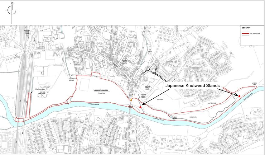
Project                                  Ecological Impact Assessment (EcIA) Part XAB Planning Application
                                         Proposed Town Park Works, Mallow, Co, Cork

Client                                   Cork County Council

Project Ref.                             2142

Report No.                               2142.02

Client Ref.                              -

Date                                     Revision                                                    Prepared By

18/05/21                                 First draft                                                 Sorcha Sheehy BSc PhD

25/05/21                                 Final                                                       Carl Dixon BSc MSc

                                         DixonBrosnan Lios Ri Na hAoine, 1 Redemption Road, Cork.
                                   Tel 086 851 1437| carl@dixonbrosnan.com | www.dixonbrosnan.com

This report and its contents are copyright of DixonBrosnan. It may not be reproduced without permission. The report is to be used only for its intended purpose. The
report is confidential to the client, and is personal and non-assignable. No liability is admitted to third parties.
©DixonBrosnan 2021.
Table of Contents
1. Introduction.................................................................................................................. 5
2. Methodology ................................................................................................................ 5
   2.1 Introduction ....................................................................................................................... 5
   2.2 Desktop Review ................................................................................................................. 5
       2.2.1 Relevant Legislation ............................................................................................................................. 6
   2.3 Survey Overview ................................................................................................................ 6
3. Receiving Environment ................................................................................................. 7
   3.1 Existing site ........................................................................................................................ 7
   3.2 Proposed Development ...................................................................................................... 8
       3.2.1 Entrances and circulation ..................................................................................................................... 8
       3.2.2 Play ....................................................................................................................................................... 8
       3.2.3 Active sports ......................................................................................................................................... 9
       3.2.4 Other amenities ................................................................................................................................... 9
       3.2.5 Landscape Improvement Works ........................................................................................................ 11
   3.3. Surface water drainage measures .................................................................................... 11
       3.3.1 Proposed Carpark - Surface & Drainage Design Details. .................................................................... 11
       3.3.2 Sustainable Drainage Design .............................................................................................................. 12
       3.3.3 Proposed Skate Park - Surface Drainage Design Details. ................................................................... 13
       3.3.4 Proposed Pump Track - Surface Drainage Design Details. ................................................................. 14
       3.3.5 Grass Pitches & Reinforced Grass Event & Temporary car park area ................................................ 14
       3.3.6 Proposed Swale drainage Basin - Surface Drainage Design Details. .................................................. 15
       3.3.7 Widening of Existing Pedestrian Bridge ............................................................................................. 16
       3.3.8 Angling Stands .................................................................................................................................... 18

4. Designated Conservation Areas .................................................................................. 20
   4.1 European (Natura 2000) Sites ........................................................................................... 21
   4.2 Nationally Protected Sites ................................................................................................ 22
   4.3 Salmonid Waters – River Blackwater ................................................................................. 24
   4.4 Important Bird Areas – Nagle Mountains .......................................................................... 24
5. Habitats ..................................................................................................................... 25
6. Flora ........................................................................................................................... 34
7. Fauna ......................................................................................................................... 34
   7.1 Otter ................................................................................................................................ 34
   7.2 Bats ................................................................................................................................. 35
       7.2.1 Bat Activity Survey (Bat Detector Survey) .......................................................................................... 38
   7.3 Other terrestrial mammals ............................................................................................... 39
       7.3.1 Badger (Meles meles) ......................................................................................................................... 39
   7.3.2 Pygmy Shrew (Sorex minutus) ........................................................................................ 39
       7.3.3 Red Squirrel (Sciurus vulgaris) ............................................................................................................ 39
       7.3.4 Pine Marten (Martes martes) ............................................................................................................ 39
       7.3.5 Hedgehog (Erinaceus europaeus)....................................................................................................... 39
       7.3.6 Irish Hare (Lepus timidus hibernicus) ................................................................................................. 40
       7.3.7 Fallow Deer (Dama dama) ................................................................................................................. 40

NIS Mallow Town Park Improvement Works                                             3                                                               DixonBrosnan 2021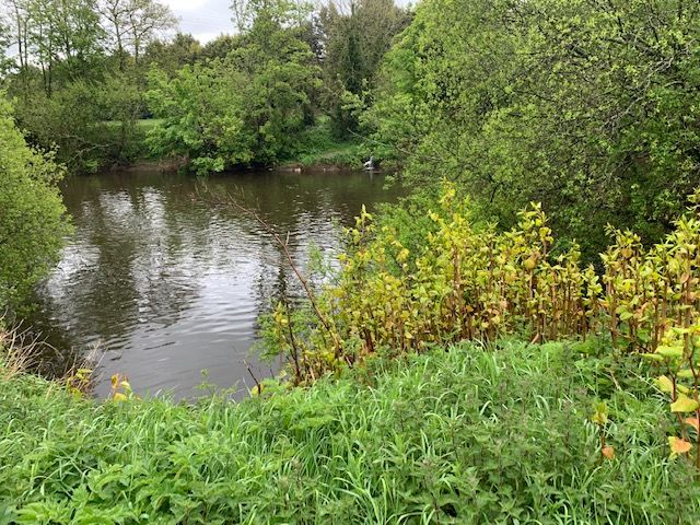
7.3.8 Sika Deer (Cervus nippon) .................................................................................................................. 40
   7.4 Reptiles and Amphibians .................................................................................................. 40
   7.5 Birds ................................................................................................................................ 41
   7.6. Invasive Species .............................................................................................................. 43
   7.7 Other species listed by NBDC as present within grid square W59 ....................................... 46
8. Water Quality ............................................................................................................. 48
      8.1 EPA Water Quality Data ........................................................................................................................ 48
   8.2 River Basin Management Plan for Ireland 2018 – 2021 (2nd Cycle)..................................... 50
9. Evaluation of Potential Impacts .................................................................................. 52
   9.1 Do Nothing’ Impact .......................................................................................................... 52
   9.2 Impact Appraisal .............................................................................................................. 53
10. Potential Impacts on Terrestrial Habitats .................................................................. 54
   10.1 Invasive Species.............................................................................................................. 55
11. Potential Impacts on Fauna....................................................................................... 56
   11.1 Protected Mammals ....................................................................................................... 56
   11.2 Birds .............................................................................................................................. 58
   11.3 Impact on aquatic species ............................................................................................... 59
   11.4 Impacts on other fauna................................................................................................... 59
12 Potential impact on water quality .............................................................................. 59
   12.1 Impacts on water quality during the construction phase .................................................. 59
   12.2 Impacts on water quality during the operation phase ...................................................... 60
13. Cumulative Impacts .................................................................................................. 62
14. Mitigation Measures................................................................................................. 63
   14.1 Construction phase mitigation measures ......................................................................... 63
   14.2 Protection of Water Quality ............................................................................................ 64
   14.3 Management of hydrocarbons and concrete ................................................................... 66
   14.4 Lighting .......................................................................................................................... 67
   14.5 Noise.............................................................................................................................. 68
   14.6 Habitats ......................................................................................................................... 68
   14.7 Otter .............................................................................................................................. 70
   14.8 Bats................................................................................................................................ 71
   14.9 Invasive species .............................................................................................................. 72
15. Conclusions ............................................................................................................... 72
References...................................................................................................................... 73
Appendices ..................................................................................................................... 75

NIS Mallow Town Park Improvement Works                                      4                                                         DixonBrosnan 2021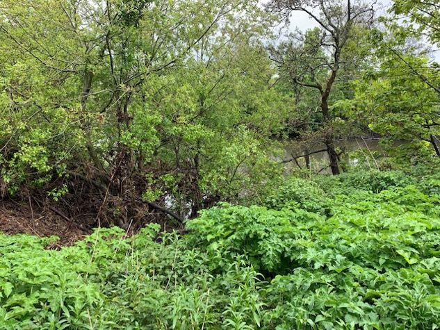
1. Introduction
DixonBrosnan Environmental Consultants were commissioned to assess the potential
ecological impacts of the proposed Town Park Works at Mallow, Co. Cork. This report
describes and evaluates the habitats with their representative flora and fauna and addresses
the potential impacts of the development on the ecology of the site and the surrounding area.

2. Methodology
2.1 Introduction

This appraisal is based on surveys of the proposed works area and a review of desktop data.
Although not part of an Environmental Impact Assessment Report (EIAR) this report follows
the structure and protocols detailed in Advice notes for preparing Environmental Impact
Statements (EPA Draft, 2015) and Draft Guidelines on the Information to be Contained in
Environmental Impact Assessment Reports’ (EPA, May 2017).

2.2 Desktop Review

A desktop study was carried out identify features of ecological value occurring within the
proposed development site and those occurring in close proximity to it. A desktop review also
allows the key ecological issues to be identified early in the appraisal process and facilitates
the planning of surveys. Sources of information utilised for this report include the following:

     •    National Parks & Wildlife Service (NPWS) - www.npws.ie

     •    Environmental Protection Agency (EPA) – www.epa.ie

     •    National Biodiversity Data Centre – www.biodiversityireland.ie

     •    County Cork Biodiversity Action Plan 2009-2014

     •    Otter Survey in relation to the Mallow Flood Relief Scheme (DixonBrosnan 2011a)

     •    Electrofishing survey for lamprey in two minor watercourses as part of the Munster
          Blackwater River (Mallow South and West) Drainage Scheme (DixonBrosnan, 2011b)

     •    Freshwater Pearl Mussel Survey Blackwater [Munster] River – Mallow (Ecofact, 2018)

     •    Bat Conservation Ireland – http://www.batconservationireland.org

     •    Birdwatch Ireland - http://www.birdwatchireland.ie/

     •    Invasive Species Ireland - http://www.invasivespeciesireland.com/

     •    Best Practice Guidance for Habitat Survey and Mapping (Heritage Council, 2011)

     •    Guidelines for Assessment of Ecological Impacts of National Road Schemes (National
          Roads Authority, 2009) and

NIS Mallow Town Park Improvement Works           5                                DixonBrosnan 2021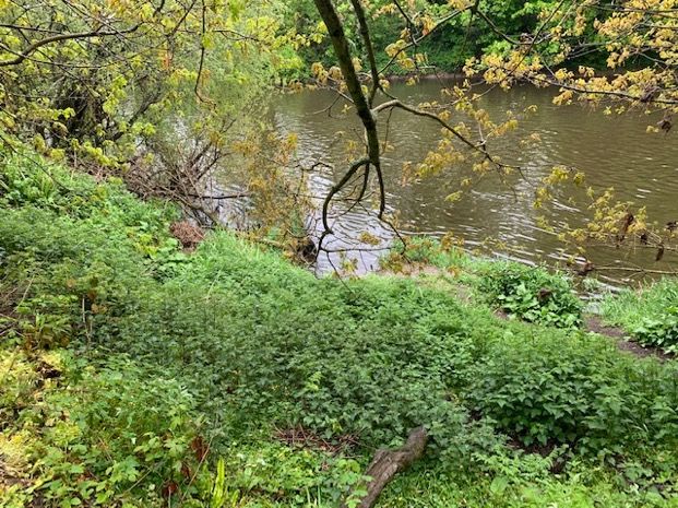
•    Environmental Impact Assessment of Projects Guidance on the preparation of the
          Environmental Impact Assessment Report (Directive 2011/92/EU as amended by
          2014/52/EU) European Union, 2017.

The appraisal of impacts follows the protocols outlined in guidelines for Assessment of
Ecological Impacts of National Road Schemes (National Roads Authority, 2009) and CIEEM
(2016) Guidelines for Ecological Impact Assessment in the UK and Ireland: Terrestrial,
Freshwater and Coastal, 2nd edition.

2.2.1 Relevant Legislation

Flora and fauna in Ireland are protected at a national level by the Wildlife Acts, 1976 to 2000
and the European Communities (Birds and Natural Habitats) Regulations 2011. They are also
protected at a European level by the EU Habitats Directive (92/43/EEC) and the EU Birds
Directive (79/409/EEC) amended in 2009 as the Directive 2009/147/EC.

Under this legislation, sites of nature conservation importance are then designated in order to
legally protect faunal and floral species and important/vulnerable habitats.

The categories of designation are as follows:

     •    Special Areas of Conservation (SAC) are designated under the European
          Communities (Birds and Natural Habitats) Regulations 2011 to comply with the EU
          Habitats Directive (92/43/EEC);
     •    Special Protection Areas (SPAs) and designated under the EU Birds Directive
          (79/409/EEC) amended in 2009 as the Directive 2009/147/EC; and
     •    Proposed Natural Heritage Areas (pNHA) are listed under the Wildlife (Amendment)
          Act, 2000. They have limited legal protection under Local Authority Development
          Plans.

2.3 Survey Overview

Site surveys were carried out on the 27th of September 2020, 10th of May 2021, 13th of May
2021 and 17th of May 2021:

     •    Habitats were mapped according to the classification scheme outlined in the Heritage
          Council publication ‘A Guide to Habitats in Ireland (Fossitt, 2000)’ and following the
          guidelines contained in ‘Best Practice Guidance for Habitat Survey and Mapping
          (Heritage Council, 2011)’;
     •    Bat surveys along River Blackwater on the 27th of September 2020 and the 13th of May
          2021;
     •    A general mammal survey with a particular focus on Otter;
     •    The proposed development area was surveyed for invasive species and
     •    All bird species recorded during the walkover survey and habitat survey were recorded.

This report was prepared by Carl Dixon MSc (Ecological Monitoring) and Dr. Sorcha Sheehy
PhD (Ecology/ornithology). Fieldwork was conducted by Carl Dixon MSc (Ecological
Monitoring), Mark Donnelly BSc (Forestry) and Cian Gill MSc (Ecological Monitoring).

Carl Dixon MSc (Ecology) is a senior ecologist who has over 20 years’ experience in ecological
and water quality assessments. He also has experience in mammal surveys, invasive species

NIS Mallow Town Park Improvement Works          6                                  DixonBrosnan 2021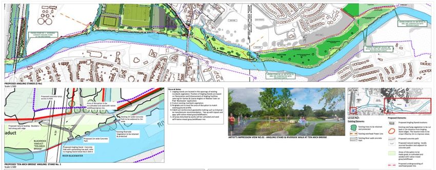
surveys and ecological supervision of large-scale projects. Projects in recent years include
the Waste to Energy Facility Ringaskiddy, Shannon LNG Project, supervision of the Fermoy
Flood Relief Scheme, Skibbereen Flood Relief Scheme, Upgrade of Mallow WWTP Scheme,
Douglas Flood Relief Scheme, Great Island Gas Pipeline etc.

Dr. Sorcha Sheehy PhD (ecology/ornithology) is an experienced ecological consultant with
over ten years’ experience. She has worked on Screening/NIS’s for a range of small and large-
scale projects with particular expertise in assessing impacts on birds. Recent projects include
bird risk assessments for Dublin and Cork Airports, Waste to Energy Facility Ringaskiddy and
Water Storage Schemes for Irish Water.

Mark Donnelly (Forestry) holds a BSc. Hons in Forestry from Bangor University, Wales, and
is a member of the Institute of Chartered Foresters. He worked as an arboricultural consultant
for the National Trust in Wales for 22 years and was a lecturer in Forest Ecology at Bangor
University. In Ireland, he has completed landscape assessments for a range of projects
including wind farms, quarries, local authorities, housing developments, roads and pipelines.

Cian Gill MSc (Ecology) is a qualified ecologist with ten years' experience working with wildlife
and ecology-based NGOs and public bodies in Ireland, the UK and the US. Past projects
include invasive species planning for the city of Rosemount, Minnesota, and the Under The
Sea project for Essex Wildlife Trust. Recent projects include ecological reports for Cork-based
housing and private developments.

3. Receiving Environment
3.1 Existing site

Mallow Town Park with accompanying Mallow Town Playground and Riverside Amenity Walk
are situated at the south of the Mallow Town Centre and Mallow Castle grounds. The proposed
development site extends along the Blackwater River, from the Railway Bridge (Blackrock
Viaduct) / N20 Motorway Bridge to Lovers Leap. The overall site is approximately 23.2 ha.The
Town Park itself is adjoined by Park Road (N72) from the north, Blackwater River from the
south, East Baltydaniel Stream (AKA Hospital Stream) to the west and Bridge Street to the
east (Figure 1).

NIS Mallow Town Park Improvement Works          7                                  DixonBrosnan 2021
Figure 1. Site location | Source Brady Shipman Martin

3.2 Proposed Development

The objective of proposed improvement works of Mallow Town Park are to enhance the park
and provide a wide range of public amenities which will be developed and integrated in a safe,
sensitive, sustainable, accessible and positive manner for all ages and abilities.

In summary, the proposed improvement works include:

3.2.1 Entrances and circulation

•    Enhancement/ refurbishment of existing 3 no. pedestrian and 2 no. vehicular entrances
     to the park from Park Road.
•    Construction of 2 no. pedestrian entrances from Park Road (N72) and 1no. new entrance
     to the existing footpath on the N20 to the west, providing better connectivity and
     accessibility to Mallow Town.
•    Widening of existing concrete riverside footpath from 2m to 3m along a length of
     c.1,540m.
•    Construction of new 3m wide concrete footpaths at a total length of c.1,230m as part of
     circulation and access network improvements. This includes the construction of a new
     path from the west end of Town Park up to the existing footpath on the N20 to the west.
•    Construction of a c.425m long 2m wide reinforced grass path along the northern edge of
     Town Park.
•    Widening of the existing pedestrian bridge (c.1.2m wide) within the Town Park over the
     Caherduggan/Spa Glen Stream to 3m in width.
3.2.2 Play

•    Refurbishment of an existing playground on the northside of the N72 to include new play
     equipment and a skate park.

NIS Mallow Town Park Improvement Works           8                               DixonBrosnan 2021
•    Construction of a ‘pump’ track (for non-powered bikes, skateboards, rollerblades,
     scooters).
3.2.3 Active sports

•    Relocation of the existing GAA pitch (145m x 90m) c.15m north, including the removal of
     the existing mounding, including demolition of former entrance gates to GAA pitch.
     Entrance plaque to be relocated and incorporated into new park entrance (opposite St
     James Avenue). Perimeter post and rail spectator fencing to pitch and ball catch
     posts/netting.
•    Retention and improvement of existing soccer and rugby pitches.
•    Provision of a grass training area (155m x 35m).
•    Provision of permanent orienteering course within the park.

3.2.4 Other amenities

•    Construction of reinforced grass multi-use events area at a surface area (c.147m x 73m).
•    Construction of angling stands to Inland Fisheries Ireland Standards along the banks of
     the Blackwater River with due consideration of the SAC designation, to include:
         o 1 no. concrete accessible stand under the Railway Viaduct/Road Bridge (N20)
            (measuring c. 5.2 x 2.5m), and
         o 4 no. fishing stands constructed of recycled plastic measuring c. 2.4 x 1.8m,
            located downstream of the Caherduggan/Spa Glen stream and Lover’s Leap with
            Castlepark to the east of the town park.
•    Construction of landscaped and permeable car park at a total surface area 2,590m2 for
     Town Park with capacity for 96 car parking spaces, including disabled and parent and
     toddler spaces.
•    Construction of a reinforced grass parking area (only for use only in association with
     authorised seasonal/summer events when the flood risk is very low). Total surface area

NIS Mallow Town Park Improvement Works         9                                 DixonBrosnan 2021
Figure 2. Proposed development arrangement | Source Brady Shipman Martin
•   4,720m2 with capacity for car parking 114 spaces, including 3no. set-down spaces, and
    include vehicular entrance to the car park.
3.2.5 Landscape Improvement Works

•   Supporting locational and wayfinding signage, seating and services, including wayfinding
    signage to nearby existing car parking.
•   Undergrounding of existing overhead power line in the Town Park to the west of Mallow
    Bridge.
•   Provision of surface water detention basin.
•   All associated site development, fencing, park furniture (seating, bike stands etc.),
    planting, landscape and biodiversity improvement works.
The proposed development will connect to existing public utilities.

3.3. Surface water drainage measures

3.3.1 Proposed Carpark - Surface & Drainage Design Details.

    •   The proposed new porous surface carpark is to be constructed on an open green field
        site to the northwest corner of the site. This area is currently used for car parking on
        occasions and is partly hardcore surfaces.

    •   The site is bounded to the north by a stone wall with existing entrances to the site.
        Proposed works will see these existing entrances upgraded to enhance the safety and
        astatic of these vehicular and pedestrian access.

    •   From current published floor risk assessments of the town park, it is an establish floor
        zone.

    •   The proposed development of the various surface facilities including the porous
        carpark will not change or intensify the current land use or create additional flood risk
        to the area.

    •   The proposed carpark area has been laid out and levels set where possible in line with
        the existing ground contours to mitigate against flood displacement as well as to
        minimise the amount of excavation and ground disturbance to the site so mitigating
        where possible the impact to potential below ground archaeology.

    •   The Carpark and road surfaces are to be constructed with a porous asphalt surface on
        a free draining stone base build up (Figure 3).
Figure 3 Porous asphalt car park surface | Source Horgan Lynch
• Hydrocarbons filtration and removal. The stone base to the carpark area is wrapped in
a special ‘Inbitex’ geotextile filter material. The filtration membrane in conjunction with
the stone build-up traps and breaks down any hydrocarbons build up within the sub-
base by microbial action. The surface water is cleaned and filtered through the Inbitex
Geotextile layers.
• Aco channel cut off drains are to be installed in front of the vehicle and pedestrian
entrance to the carpark and these drainage channels are connected to a new 150mm
dia storm drainage pipe which discharge to a proposed adjacent soakaway with-in the
site.
• As noted above the use of a porous carpark surface and associated filter stone build
up minimises the depth of excavation and extent of ground disturbance associated with
standard hard paved carparks, piped gullies and drainage pipe network.
• This porous carpark system also allows flexibility in the depth of excavation when
archology features are encountered as the stone build up can be altered as necessary
without effecting the drainage flow.
3.3.2 Sustainable Drainage Design
• The carpark and site wide drainage design is based on Sustainable Drainage Design
(SUDS) drainage design which both infiltrates and attenuates the surface water
drainage on the site and ensures the storm water runoff from the developed site is
restricted to at or below the current undeveloped green field runoff.
• This attenuation of the storm water runoff will ensure the development of the site does
not contribute to increased flooding risk downstream from the area as the flow is being
restricted to greenfield run-off rates. Hence there will be no increase in the overall
discharge from the site as a result of the proposed development.
• As set out above and detailed in the accompanying drawings the carpark and
surrounding surfaced covers approximately 4200m2.
NIS Mallow Town Park Improvement Works 12 DixonBrosnan 2021• The carpark which is a porous asphalt surface drains into a 400mm deep clean
drainage stone build up with 50% voids.
• Calculation for site attenuation:
Surface paved area with attenuation under 3200m2
Soil infiltration rate – f = 2.19x10⁻⁶m/s
Welted are of pit 50% full – as50 = 74.8m2
Required Storage Estimate for site = 351m3
Available storage capacity within carpark build up = 3200m2x0.4 = 1280m3 x 50%
= 640m3
Time for emptying attenuation to half volume due to soil infiltration – ts50 =
351x106 x {0.5/(74.8x106x2.19x10-6)} = 1071350 sec = 297.6 Hours (12.4
days)As can be seen from the above figures there is significant storage capacity
within the carpark build up to facilitate the attenuation of storm water.
• As can be seen from the above figures there is significant storage capacity within the
carpark to facilitate the attenuation of storm water.
• In addition to attenuation capacity, the proposed porous carpark surface and store
build up system also provides for infiltration. The infiltration rate of the ground is
sufficiently capable of handling the storm water values.
3.3.3 Proposed Skate Park - Surface Drainage Design Details.
• It is proposed to construct a new skate park in the area of the existing playground to
the north of the site.
• The proposed skate park features will include a number of specific skating shapes,
surface finishes and structures, including a Hags unplay buridos and Kompan triple
cube play structures.
• The skate park is proposed to be installed using existing ground levels with limited
excavations required.
• The new surfaces are a mix of concrete in the skate areas, tar and chip footpaths,
grass and meadow areas and jungle mulch in the play areas. The concrete surfaces
are laid to falls that will drain into free draining areas and localised soakaway within
the site, there is an Aco-drain channel at the southern entrance to the skate park that
will drain to adjacent soakaways within the site. Remaining surfaces are laid on a stone
bedding which will be free draining.
• The existing playground areas are substantially covered in impermeable tarmac
surfaces with marginal grass verges around the northwest perimeter of the site.
• The new proposed grass and play areas to the redeveloped playground will be
permeable free draining surface.
NIS Mallow Town Park Improvement Works 13 DixonBrosnan 2021• The total proposed new impermeable hard paved surfaces of the skate park and
footpath will be substantially less than the existing impermeable tarmac surface area
of the existing playground. Circa 40% reduction in hard surface area.
• The infiltration value of the ground over the areas of the surfaces are sufficient in
dealing with the storm water run-off values for the area.
• There will be no additional storm water runoff generated from the development of the
playground surfaces within the existing site. The provision of soakaways and the free
draining stone bedding has been made to facilitate additional infiltration of surface
water away from the immediate play areas to prevent ponding of same during heavy
rainfall.
3.3.4 Proposed Pump Track - Surface Drainage Design Details.
• It is proposed to construct a Pump Track in an existing green field area of the site. To
the south of the proposed skate park.
• The proposed pump track consists of a porous asphalt surface which is laid to fall to
create the desired mounds.
• The pump track is proposed to be installed using existing ground levels with limited
excavations required. Excavated material from one area of the track can be used as
fill in other areas in order to create the mounds. This limits the amount of imported fill
required.
• The proposed regrading of the ground at the pump track and the surrounding park
areas have been laid out and levels designed so that the overall surface volumes are
equivalent to the existing area so as not to create any overall flood displacement issue
within the park.
• The bitumen macadam surface will be laid such that the surface water will run-off and
drain locally into the surrounding grass margins.
• The mounds and levels will be shaped so water is not trapped around the pump track
area and will be free to naturally drain and flow towards the river.
3.3.5 Grass Pitches & Reinforced Grass Event & Temporary car park area
• There is an existing grass soccer, rugby and GAA pitch within the town park.
• The proposed development includes a new and refurbished grass soccer, rugby and
GAA playing pitches and a grass training area which are proposed to be provide under
this re development of the town park.
• The soccer and rugby pitched will be retain in their existing location.
• The GAA pitch will be reoriented and moved south, and the trees and embankment
mounds removed to provide space for the pump track and also to improve the general
layout and presentation of the park area.
NIS Mallow Town Park Improvement Works 14 DixonBrosnan 2021• The re-grading of the grass pitches and the removal of the grass embankment
spectator mounds will also assist in the better drainage and flood flow/release from the
park.
• All pitches and training area will be regraded and reseeded to provide free draining
high quality sport standard grass playing surfaces.
• The sub-base to the grass surfaces will be formed with a ameliorate soil and gravel
mix which will aid in the natural drainage of the surfaces into the free draining sandy
gravely sub soil which underlies the park area.
• It is proposed to form new temporary seasonal event and carpark areas to the
southwest of the Park by reseeding these areas with reinforced grass surfaces.
• The areas will be natural grass with reinforced polypropylene plastic mesh elements
blended with in the soil to from a composite mesh reinforced rootzone capable of taking
vehicle loading.
• These surfaces will be naturally free draining grass surfaces with equal or better
porosity then the existing grass surfaces of the park.
3.3.6 Proposed Swale drainage Basin - Surface Drainage Design Details.
• As stated, the town park is in a flood zone and is subject to seasonal flooding. Under
fluvial 1% (1 in 100 year storm) AEP the flood depth across the park is >2.0m.
• During periods of flooding the Town Park, which is part of the natural flood pain for the
river black water, floods as does the N72 Park road to the northern boundary of the
Park.
• When the river flooding subsides the flood waters generally flow back from the roadway
and the Park to the river. However, some water ponds and is trapped from flowing
directly to the river due to the higher-level of the ground along the footpath to the
southern side of the park.
• This trapped surface water eventually naturally drains through the sandy gravely soil
of the park.
• It is proposed to construct a swale drainage basin in an existing green field area to the
southwest of the site just east of the Bridge.
• The intention of the swale drainage basin is not to prevent flooding but to provide a
drainage channel to which surface water from the park and the northwest area of the
Park Road can be directed and temporarily retained in periods of high river flood before
discharged to the river as the flood level recede.
• The detention basin will have storage capacity is approximately 1450m3
• The swale, as detailed on the drainage drawings, shall be a formed drainage basin
channel to the low lying southwest area of the park. The base of the channel shall be
shaped and graded with a steady fall towards the river to the southwest.
NIS Mallow Town Park Improvement Works 15 DixonBrosnan 2021• When not in flood, the proposed swale detention basin will form a dry grass
“amphitheatre” with grass meadow planting.
• The channel shall be pipes thought the raised footpath embankment and discharge on
the river side of the embankment via a formed concrete outfall head wall and slip way
directly to the river.
• The piped outfall from the swale detention basin shall be fitted with a Tideflex duckbill
non return valve fitted to provide end of pipe backflow prevention and flooding
protection to the line.
3.3.7 Widening of Existing Pedestrian Bridge
• It is proposed to widen the existing pedestrian bridge on the far East corner of the site.
The existing bridge is 1665mm wide and the proposal is to add another 1770mm to
the bridge width making it 3000mm wide overall.
• The construction will involve the pouring of 2 no. reinforced concrete abutments. 1 to
each side of the river. Precast concrete bridge beams will be placed on these
abutments and a finished screed will be poured over to complete the bridge surface.
New 1.1m high powder coated railings will be provided.
• This method allows for the construction without disturbing the existing trunk watermain
contained within the existing bridge deck. The bridge abutments will be kept back from
the river to ensure no debris enters same.
• The proposed bridge will match the other bridges on Mallow River walkway and Town
park.
• Drawings of the proposed bridge widening works are included in Figures 4, 5 and 6.
Proposed bridge
widening
Figure 4. Location of Proposed Bridge Widening Drawing | Source Brady Shipman Martin
NIS Mallow Town Park Improvement Works 16 DixonBrosnan 2021Figure 5. Extract from Architects Proposed Bridge Widening Drawing | Source Brady Shipman Martin Figure 6. Proposed pedestrian bridge widening work | Extract from Horgan Lynch Drawing CQ15-024 NIS Mallow Town Park Improvement Works 17 DixonBrosnan 2021
3.3.8 Angling Stands

It is proposed to construct a series of angling stands on the Northern bank of the River
Blackwater. 4 No. typical angling stands and 1 No. Accessible angling stand.

     •    These are to be located in the openings of the existing riverbank vegetation. This is to
          minimise the disruption to the existing riverbank and vegetation. Refer Figure 7 for
          locations.

     •    Proposed grassed areas of disruption made good with geotextile protection matting
          (Enkamat), topsoiled and seeded with native grass / wildflower mix.

     •    The accessible angling stand will be formed with precast concrete slabs supported on
          screw piles and cantilevered reinforced ground beams. This will limit the excavation
          and works required along the river embankment. Refer to Figure 8.

     •    The typical angling stands will consist of 900mm wide steps leading down to the
          platform. This platform will be formed with black recycled plastic posts and non-slip
          decking boards all supported from screw piles. These are lightweight pieces and as
          such the disruption and excavation works adjacent the river will be minimal. Refer to
          Figure 9 below.

NIS Mallow Town Park Improvement Works           18                                 DixonBrosnan 2021
Angling stand no. 5
Angling stands no.3 and 4
Angling stand no.1
Angling stand no.2
Figure 7. Angling stand locations | Source Brady Shipman MartinFigure 8. Angling Stand Section | Source Horgan Lynch Figure 9. Typical angling stand section | Source Horgan Lynch 4. Designated Conservation Areas Special Areas of Conservation (SACs) and candidate SACs are protected under the Habitats Directive 92/43/EEC and the European Communities (Birds and Natural Habitats) Regulations 2011, as amended. Special Protection Areas (SPAs) are protected under the Birds Directive 2009/147/EC and European Communities (Birds and Natural Habitats) Regulations 2011, as amended. Collectively, these sites are referred to as Natura 2000 sites or European sites. Natural Heritage Areas and proposed Natural Heritage Areas (NHAs/pNHAs) are national designations under the Wildlife Act 1976, as amended. A NHA/pNHA is designated for its wildlife value and receives statutory protection. A list of pNHAs was published on a non- statutory basis in 1995, but these have not since been statutorily proposed or designated. Consultation with the NPWS is still required if any development is likely to impact on a pNHA. Part of the proposed development overlaps with the Blackwater River (Cork/Waterford) SAC. The proposed development area does not form part of any Natural Heritage Area (NHA), Special Protection Area (SPA), Nature Reserve, or National Park.
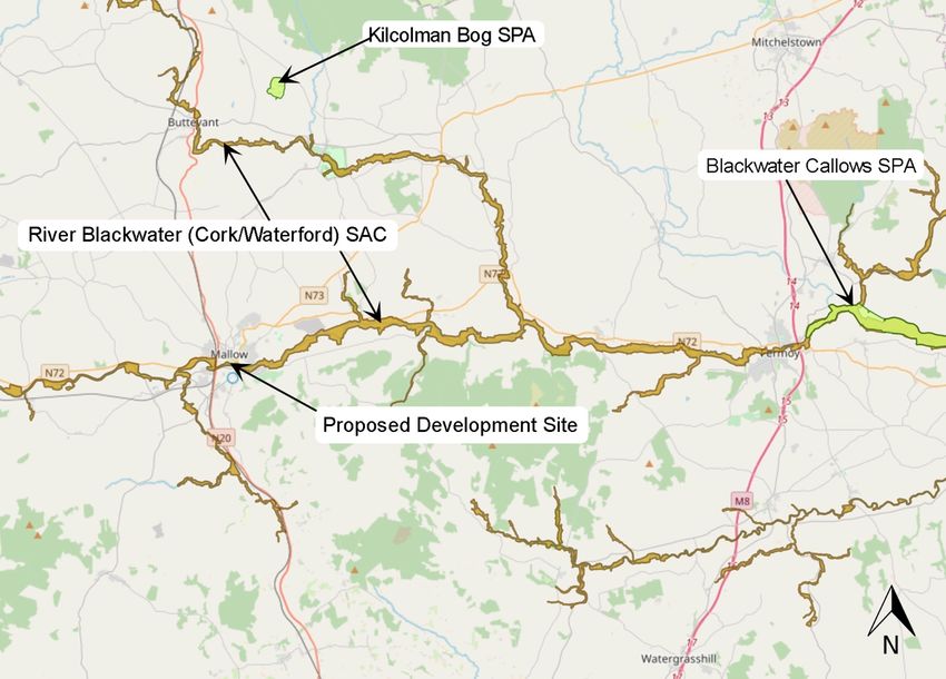
4.1 European (Natura 2000) Sites

Part of the proposed development site is located within the Blackwater River (Cork/Waterford)
SAC. European sites within the zone of influence of the proposed development site, along
with their distance from the proposed development site, are listed in Table 1 and are shown
in Figure 10.

Table 1. Designated sites and their location relative to the proposed development site.

 Site                                          Code            Approx. Distance at Closest Point.

 Special Area of Conservation (SAC)

 Blackwater River (Cork/Waterford)               002170          0m.

 Special Protection Area (SPA)

 Kilcolman Bog                                   004095          12.2km N.

 Blackwater Callows SPA                          004094          26.3km east.

Figure 10. Natura 2000 Sites within zone of influence proposed development site | Source: EPA
Envision mapping https://gis.epa.ie/EPAMaps/) | Not to scale

The proposed development site is potentially connected to three Natura 2000 sites listed in
Table 1 i.e. River Blackwater (Cork/Waterford) SAC, Kilcolman Bog SPA and Blackwater
Callows SPA, (Refer to Figure 10).

EcIA Mallow Town Park Improvement Works            21                                       DixonBrosnan 2021
No pathway exists by which the proposed development could impact on any other Natura
2000 site due to the distances involved and/or the lack of any significant hydrological,
hydrogeological or any other relevant connection pathways.

The River Blackwater (Cork/Waterford) SAC is a very large site drains a major part of County
Cork and five mountain ranges. The site supports a high diversity of Annex I habitats and
Annex II species of the E.U. Habitats Directive, including Atlantic salmon and Otter. The site
designated as the Blackwater River cSAC consists of the freshwater stretches of the River
Blackwater as far upstream as Ballydesmond and as far downstream as the tidal stretches
into Youghal Harbour as well as the many tributaries along the way, the larger of which include
the Licky, Bride, Flesk, Chimneyfield, Finisk, Araglin, Awbeg (Buttevant), Clyda, Glen, Allow,
Dalua, Brogeen, Rathcool, Finnow, Owentaraglin and Awnaskirtaun. The extent of the
Blackwater and its tributaries in this site flows through the counties of Kerry, Cork, Limerick,
Tipperary and Waterford. The designated site covers a total area of 15,048 ha.

Kilcolman Bog SPA is situated on the southern foothills of the Ballyhoura Mountains in Co.
Cork. The site comprises a quaking fen fed by calcareous groundwater, with areas of reed
swamp, freshwater marsh and wet grassland. There is a small permanent lake but in winter a
large, flooded area is usual.

The Blackwater Callows SPA is of importance for its populations of wintering waterfowl,
including an internationally important population of Whooper Swan and nationally important
populations of Wigeon, Teal and Black-tailed Godwit. The presence of Whooper Swan, as well
as Little Egret, is of particular note as these species are listed on Annex I of the E.U. Birds
Directive. Part of the Blackwater Callows SPA is a Wildfowl Sanctuary.

Potential impacts on designated Natura 2000 sites (SAC/cSAC/SPA) are specifically
addressed in a Report for Screening for Appropriate Assessment (AA) and Natura Impact
Statement (NIS) which has been submitted as part of this application. This report concluded
the following:

It has been objectively concluded following an examination, analysis and evaluation of the
relevant information, including in particular the nature of the predicted effects from the
proposed development and with the implementation of the mitigation measures proposed, that
the construction, operation and decommissioning of the proposed development will not
adversely affect (either directly or indirectly) the integrity of any European site, either alone or
in combination with other plans or projects. There is no reasonable scientific doubt in relation
to this conclusion. The competent authority will make the final determination in this regard.

4.2 Nationally Protected Sites

Consultation of the NPWS online database identified eleven Natural Heritage Areas (NHAs)
and proposed Natural Heritage Areas (pNHAs) within 15km of the proposed development.
These are listed in Table 2 and their distances from the site of the proposed development are
provided. The location of these pNHAs are illustrated in Figure 11. The majority of these
NHAs/pNHAs on the River Blackwater are located upstream of the proposed development
site. Three pNHAs are located downstream within 15km i.e. Blackwater Valley (Ballincurrig
Wood) pNHA, Blackwater Valley (Kilcummer) pNHA and Blackwater Valley Kilavullen pNHA.
These are designated for terrestrial habitats and no potential impact pathway has been

EcIA Mallow Town Park Improvement Works          22                                   DixonBrosnan 2021
identified. Therefore no direct source-pathway-receptor link of significance between the area
of the proposed development and any NHA or pNHA has been identified.

Table 2. NHAs & pNHAs within 15km of the Proposed Development

 NHAs & pNHAs                             Site Code           Distance from proposed
                                                              development at closest point

 Blackwater Valley Kilavullen pNHA        001080              9.9km E

 Awbeg Valley (Above Doneraile)           000075              10.5km NNE
 pNHA

 Blackwater Valley (Ballincurrig Wood)    001793              11.9km E
 pNHA

 Eagle Lough pNHA                         001049              12.0km N

 Kilcolman Bog pNHA                       000092              12.3km N

 Blackwater Valley (Kilcummer) pNHA       001794              13.2km E

 Awbeg Valley (Castletownroche)           001561              13.7km NE
 pNHA

 Awbeg Valley (Below Doneraile) pNHA      000074              14.1km NE

 Ballyhoura Mountains pNHA                002036              14.5km NNE

 Ballinvonear Pond pNHA                   000012              14.6km NNE

 Boggeragh Mountains NHA                  002247              15.1km SW

EcIA Mallow Town Park Improvement Works               23                         DixonBrosnan 2021
Figure 11. NHAs and pNHAs within 15 km radius of proposed development site | Source: EPA Envision mapping (https://gis.epa.ie/EPAMaps/) | Not to scale 4.3 Salmonid Waters – River Blackwater The River Blackwater main channel is a designated salmonid river in accordance with EU Directive 78/659 (SI No 293 of 1988) and as such receives protection under S.I. No. 293/1988: European Communities (Quality of Salmonid Waters) Regulations, 1988. The River Blackwater supports resident Brown Trout (Salmo trutta fario), a population of Sea Trout (both Salmo trutta) in addition to a significant and biologically valuable population of Atlantic salmon (Salmo salar). Atlantic Salmon is listed under Annex II and V of the EU Habitats Directive. 4.4 Important Bird Areas – Nagle Mountains Important Bird and Biodiversity Areas (IBAs) are sites selected as important for bird conservation because they regularly hold significant populations of one or more globally or regionally threatened, endemic or congregator bird species or highly representative bird assemblages. The European IBA programme aims to identify, monitor and protect key sites for birds all over the continent. It aims to ensure that the conservation value of IBAs in Europe (now numbering more than 5,000 sites or about 40% of all IBAs identified globally to date) is maintained, and where possible enhanced. The programme aims to guide the implementation of national conservation strategies, through the promotion and development of national protected-area programmes. Through their designation they aim to form a network of sites ensuring that migratory species find suitable breeding, stop-over and wintering places along their respective flyways. The function of the Important Bird Area (IBA) Programme is to identify, protect and manage a network of sites that are important for the long-term viability of naturally occurring bird EcIA Mallow Town Park Improvement Works 24 DixonBrosnan 2021
populations, across the geographical range of those bird species for which a site-based
approach is appropriate. The proposed development site lies approximately 2km northwest of
the Nagle Mountains IBA (Site Code: n/a).

While the IBA criteria from 2005 list 9 pairs as present within the Nagle Mountains, in 2015
just 5 pairs were estimated to be breeding in this area (Ruddock et al. 2016). Hen Harrier are
listed under Annex I of the E.U. Birds Directive. In Ireland, small birds and small mammals
appear to be the most frequently taken prey.

The site qualifies for designation under the following IBA Criteria (2000):

•     C6 - The site is one of the five most important in the European region in question for a
      species or subspecies considered threatened in the European Union.

Table 3. Provides a summary of the Nagle Mountains IBA trigger species.

    Species                               Current    Season     Year(s) of   Population       IBA Criteria
                                          IUCN Red              estimate     estimate         Triggered
                                          List
                                          Category
    Hen Harrier (Circus cyaneus)          LC         Breeding   2005         9     breeding   C6
                                                                             pairs

There is no suitable nesting habitat for Hen Harrier within the proposed development site.
While Hen Harrier could potentially overfly the site during the winter months, when they tend
to be more widely disturbed, the proposed development site does not provide valuable
foraging habitat for this species.

5. Habitats
Site surveys were carried out on the 27th of September 2020, 10th of May 2021, 13th of May
2021 and 17th of May 2021. Habitat mapping was carried out in line with the methodology
outlined in the Heritage Council Publication, Best Practice Guidance for Habitat Survey and
Mapping (Heritage Council, 2011). The terrestrial and aquatic habitats within the proposed
development site were classified using the classification scheme outlined in the Heritage
council publication A Guide to Habitats in Ireland (Fossitt, 2000) and cross referenced with
Annex I Habitats where required.

A current overview of habitats recorded within the site is shown in the habitat maps below
(Figures 12-15) and the habitats recorded on site are described in Table 4. Site photographs
are included in Appendix 2. The ecological value of habitats has been defined using the
classification scheme outlined in the Guidelines for Assessment of Ecological Impacts of
National Road Schemes (National Roads Authority, 2009) which is included in Appendix 1. It
should be noted that the value of a habitat is site specific and will be partially related to the
amount of that habitat in the surrounding landscape. Habitats that are considered to be good
examples of Annex I and Priority habitats are classed as being of International or National
Importance. Semi-natural habitats with high biodiversity in a county context and that are
vulnerable, are considered to be of County Importance. Habitats that are semi-natural, or
locally important for wildlife, are considered to be of Local Importance (higher value) and sites
containing small areas of semi-natural habitat or maintain connectivity between habitats are

EcIA Mallow Town Park Improvement Works              25                                   DixonBrosnan 2021
considered to be of Local Importance (lower value). No Annex I habitats were recorded within
the proposed development site.
Table 4. Habitat present and their relative value.
Habitat Comments Habitat Value
Immature These wide-open areas of park-like habitat, east of Noted that habitats within
Woodland (WS2) Mallow Bridge (Figure 14), have been recently European sites are considered
planted with primarily native species, most of which of International importance.
are immature (under 5m tall). Species include Sessile Based on the characteristics of
Oak Quercus petraea, Silver Birch Betula pendula, this habitat it is considered of
Goat Willow Salix caprea, Alder Alnus sp., as well as Local importance (higher
the non-native Norway Maple Acer platanoides. Most value)
of these trees are of the same age/height and have
been planted as part of a planting programme, known
as the Neighbourwood Plantation. The trees are
planted in same species and mixed species groups
There are occasional mature trees.
This habitat is located within the Blackwater River
(Cork/Waterford) SAC but is not a qualifying habitat
for this SAC and is considered of local importance
(higher value).
Treelines (WL2) Along both the northern and southern paths running Noted that habitats within
through the area east of the Old Mallow Bridge, European sites are considered
treelines of mature trees occur at regularly-spaced of International importance.
intervals, approximately 4-5m apart (Figure 14). Based on the characteristics of
These are composed almost entirely of Norway this habitat it is considered of
Maple, which are less ecologically valuable than Local importance (higher
native species but still provide habitat and foraging for value)
birds and invertebrates.
This habitat is located within the Blackwater River
(Cork/Waterford) SAC but is not a qualifying habitat
for this SAC and is considered of local importance
(higher value).
Recolonising Bare Small areas of this habitat occur by the Viaduct and
Ground (ED3)/ Dry the new wooden bridge, where it is occurs in Noted that habitats within
Meadow/ Grassy conjunction with dry meadow and grassy verge (GS2) European sites are considered
Verges (GS2) habitat (Figure 11). of International importance.
Based on the characteristics of
This habitat is located within the Blackwater River this habitat it is considered of
(Cork/Waterford) SAC but is not a qualifying habitat Local importance (higher
for this SAC and is considered of local importance value)
(higher value).
Buildings and This habitat includes the footpaths and occasional
artificial surfaces concrete areas within the park. Noted that habitats within
BL3 European sites are considered
This habitat is located within the Blackwater River of International importance.
(Cork/Waterford) SAC but is not a qualifying habitat Based on the characteristics of
for this SAC and is considered of local importance this habitat it is considered of
(lower value). Local importance (lower value)
Riparian Woodland Prior to agricultural and (more recent) recreational
WN5/Broadleaved improvements to the park, the alluvial soil would Noted that habitats within
Woodland WD1 probably have supported a mosaic of alluvial European sites are considered
woodland and wet oak-ash woodland. There is a small of International importance.
EcIA Mallow Town Park Improvement Works 26 DixonBrosnan 2021Habitat Comments Habitat Value
strip of broadleaved woodland remaining along the Based on the characteristics of
edge of the river and drainage ditches. These areas this habitat it is considered of
include islands in the river dominated by Reed Canary Local importance (national
Grass with willows (Salix cinerea and Salix fragilis). value)
There is also marsh vegetation (GM1) including
meadowsweet, Purple Loostrife Lythrum salicaria and
Wild Angelica Angelica archangelica (Figure 11-14).
Further back from the water’s edge, the woodland
contains Ash, Sycamore, Alder and Willow species,
and is best described as mixed broadleaved woodland
(WD1). Planted species include Black Poplar and
Lombardy Poplar. Because of its intimate association
with the riparian woodland, this woodland is classified
as being of National Importance.
East of Old Mallow Bridge, the woodland area
bordering the river consists primarily of Norway
Maple, Goat Willow and Silver Birch, with occasional
Sycamore, Wych Elm Ulmus glabra, Beech Fagus
sylvatica and Hawthorn Crataegus monogyna. The
understory includes Creeping Buttercup Ranunculus
repens, Cow-Parsley Anthriscus sylvestris, Lords and
Ladies Arum alpinum, and Dog-Rose Rosa canina.
Understorey species include Nettle, Hogweed
Heracleum sphondylium, Cleavers Galium aparine
and Alexanders Smyrnium olusatrum are common
(Figure 13 and 14).
It is noted that there is no Alluvial woodland 91E0
mapped in the vicinity of the proposed development
site (NPWS 2012). The closest area of this habitat is
located approximately 6km downstream.
Japanese Knotweed and Himalayan Balsam were
noted within this habitat. Their positions have been
marked on the Invasive Species Map (Figure 17).
This habitat is located within the Blackwater River
(Cork/Waterford) SAC but is not a qualifying habitat
for this SAC and is considered of local importance
(higher value).
Amenity Grassland The Town Park and areas east of the Old Mallow
GA2 Road bridge consist of Amenity Grassland (Figure Noted that habitats within
12). European sites are considered
Over 50% of it is within the Blackwater River of International importance.
(Cork/Waterford) SAC but is not a qualifying habitat Based on the characteristics of
for this SAC and is considered of local importance this habitat it is considered of
(higher value). Local importance (higher
value)
Scattered Trees & Within the town park there are individual trees and
Parkland WD5 groups of trees, classified as Scattered Trees and Noted that habitats within
Parkland (WD5). Trees include Ash and Birch. East European sites are considered
of the bridge, there are individual Sessile Oaks. of International importance.
Based on the characteristics of
This habitat is located within the Blackwater River this habitat it is considered of
(Cork/Waterford) SAC but is not a qualifying habitat Local importance (higher
for this SAC and is considered of local importance value)
(higher value).
EcIA Mallow Town Park Improvement Works 27 DixonBrosnan 2021Habitat Comments Habitat Value
Drainage Ditches A drainage ditch is located to the east of the Mallow
FW4 Bridge and drains into the River Blackwater. This is a Noted that habitats within
modified wet channel which overflows from the Spa European sites are considered
Glen stream when flow levels rise. It is of minimal of International importance.
fisheries value. Japanese Knotweed was recorded Based on the characteristics of
both upstream and downstream of the footbridge. this habitat it is considered of
(Figure 13). Local importance (higher
value)
This habitat is located within the Blackwater River
(Cork/Waterford) SAC but is not a qualifying habitat
for this SAC and is considered of local importance
(higher value).
Depositing The Spa Glen Stream is located near the eastern end
Lowland River FW2 of the proposed development site (Figure 14) and Noted that habitats within
flows into the River Blackwater within the Blackwater European sites are considered
River (Cork/Waterford) SAC. This is a modified of International importance.
waterbody with wetland vegetation and/or woodland Based on the characteristics of
on the banks. The crossing of this small watercourse this habitat it is considered of
is via an existing foot bridge. At the crossing point Local importance (higher
there is a mixture of Sycamore and Poplar with an value)
understorey of Nettle, Ivy, Elm, Hemlock Water
Dropwort, Willow, Marsh Marigold, Bramble and
Rosebay Willowherb. No trees with the structural
elements to be of value for bats were recorded. Levels
of siltation are relatively high with filamentous algae
noted. This small stream has the potential to support
fish species such as eel and possibly small numbers
of Brown Trout but it is not of significant value for these
species. Himalayan Balsam was noted in proximity to
the footbridge.
The East Baltydaniel discharges into the River
Blackwater to the east of the railway bridge (Figure
12). This is a small watercourse of minimal fisheries
value with Blackthorn. Hawthorn, Ivy, Remote Sedge,
Hemlock and Water Dropwort noted along its banks.
Sediment levels and levels of filamentous algae are
high.
This habitat has links to the Annex I habitat
Watercourses of plain to montane levels with the
Ranunculion fluitantis and Callitricho-Batrachion
vegetation (3260) which is also a qualifying interest
for the Blackwater River (Cork/Waterford) SAC. This
is not a significant example of this habitat type.
This habitat is located within the Blackwater River
(Cork/Waterford) SAC but is not a qualifying habitat
for this SAC and is considered of Local importance
(Higher value).
Eroding/upland The River Blackwater is a designated SAC and International importance.
rivers (FW1) it supports resident and/or regularly occurring
populations of species listed in Annex II of the
Habitats Directive and habitats listed on Annex 1
EcIA Mallow Town Park Improvement Works 28 DixonBrosnan 2021You can also read