2018 WATERSHED MANAGEMENT PLAN UPPER CHATTAHOOCHEE WATERSHED - Produced by; Georgia Mountains Regional Commission PO Box 1720 Gainesville, GA ...
←
→
Page content transcription
If your browser does not render page correctly, please read the page content below
2018 WATERSHED MANAGEMENT PLAN
 UPPER CHATTAHOOCHEE WATERSHED

                  Produced by;
     Georgia Mountains Regional Commission
                  PO Box 1720
              Gainesville, GA 30503

                   July, 2018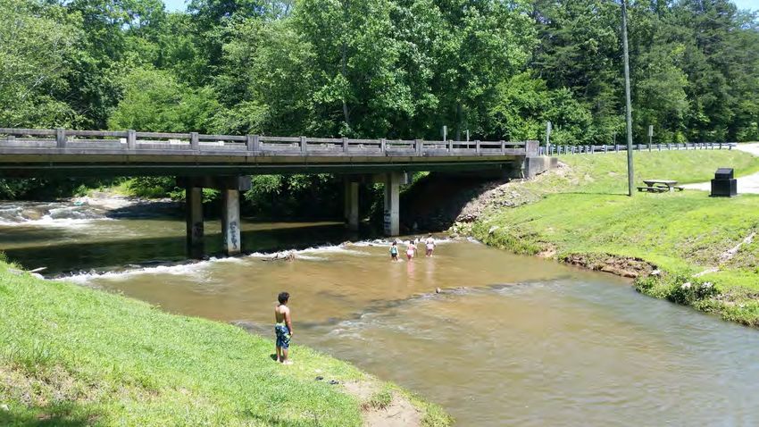
2018 WATERSHED MANAGEMENT PLAN
                  UPPER CHATTAHOOCHEE WATERSHED

                                   TABLE OF CONTENTS

INTRODUCTION
   PURPOSE                                             1
   WATERSHED PLANNING IN GEORGIA                       1
   PROJECT SCOPE                                       2
   THE GMRC                                            3

WATERSHED PROFILE                                      4
  WATERSHED LOCATION AND GENERAL DESCRIPTION            4
  NATURAL FEATURES AND CONDITIONS                       5
  ANTHROPOGENIC FEATURES                               21
  WATER QUALITY IMPAIRMENTS AND TMDLS                  24

WATERSHED ASSESSMENT                                   29
  VISUAL FIELD SURVEY                                  29
  TARGETED MONITORING RESULTS                          38
  ADVISORY COUNCIL AND PUBLIC INVOLVEMENT              42

MITIGATION PROGRAM                                     44
   WATER QUALITY GOALS                                 44
   IMPAIRMENT SOURCE ASSESSMENT                        45
   EXISTING AND RECOMMENDED MANAGEMENT MEASURES        50
   POTENTIAL FUNDING SOURCES                           56
   PROPOSED EDUCATION AND OUTREACH                     57
   IMPLEMENTATION SCHEDULE                             58
   PROGRAM MONITORING, CRITERIA AND MILESTONES         59

APPENDICES                                             60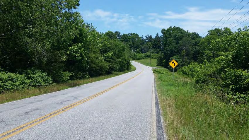
Upper Chattahoochee Watershed
                                                                       Watershed Management Plan - 2018

                                            INTRODUCTION

PURPOSE

This document is the Watershed Management Plan (WMP) for the identified segment of the Upper
Chattahoochee River. The objective of a WMP is to identify and prioritize significant sources of pollution
causing impairment in a watershed, determine effective management practices that will reduce
pollutant loads from those sources, and seek funds and other resources to install the pollution controls
and restore water quality in the impaired water body.

The Upper Chattahoochee River (HUC10 #0313000101), which features the river’s headwaters and
prominent streams leading up to the top of Lake Lanier, has a beneficial water use classification of
recreation and drinking and is currently listed as an impaired water body. The targeted segment has
been identified as contaminated/partially contaminated by the Georgia Department of Natural
Resources (DNR) and in need of remediation. The degree of impairment is classified as not supporting
uses and the TMDL for this segment of the Chattahoochee River is set at a target level that will allow the
water body to achieve water quality standards necessary for the beneficial use classification of fishing.

In this particular instance, the contamination stems from non-point sources and has been added to the
list of streams for Total Maximum Daily Load (TMDL) planning and water quality restoration. An original
TMDL assessment and Implementation Plan has already been developed and some progress made with
regards to remediation measures by local stakeholders in restoring stream banks and promoting septic
tank maintenance standards. This WMP will provide a summary of progress and of recent monitoring
efforts, then produce an updated Implementation Plan for ultimately achieving water quality. The
results of this WMP will be used to coordinate local and State assisted remediation measures for the
next 5-10 years.

WATERSHED PLANNING IN GEORGIA

Georgia is home to nearly 10 million people and one of the most naturally diverse states in the country,
featuring mountains and valleys to the north, thousands of acres of farmlands in the south and the
marshlands along the coast. The Georgia Department of Natural Resources (DNR) is the State agency
charged with management and protection these natural resources, and within the DNR structure the
Environmental Protection Division (EPD) is responsible for protecting Georgia's air, land, and water
resources through the authority of state and federal environmental statutes. These laws regulate public
and private facilities in the areas of air quality, water quality, hazardous waste, water supply, solid
waste, surface mining, underground storage tanks, and others. EPD also issues and enforces all state
permits in these areas and has full delegation for federal environmental permits except Section 404
(wetland) permits.

As part of their approach to improved water resource protection, EPD employs a watershed-based
approach to assessing and managing conditions that impact water quality. A watershed approach
provides a comprehensive and effective means for examining the factors that affect all surface waters,
including both point and nonpoint sources of pollution. To this end, the well-being of Georgia’s streams,
rivers, ponds and lakes are addressed through improvement plans and studies that consider the full
context of drainage basins. This helps to account for historical activities, ongoing land uses, and future

                                                                                                        1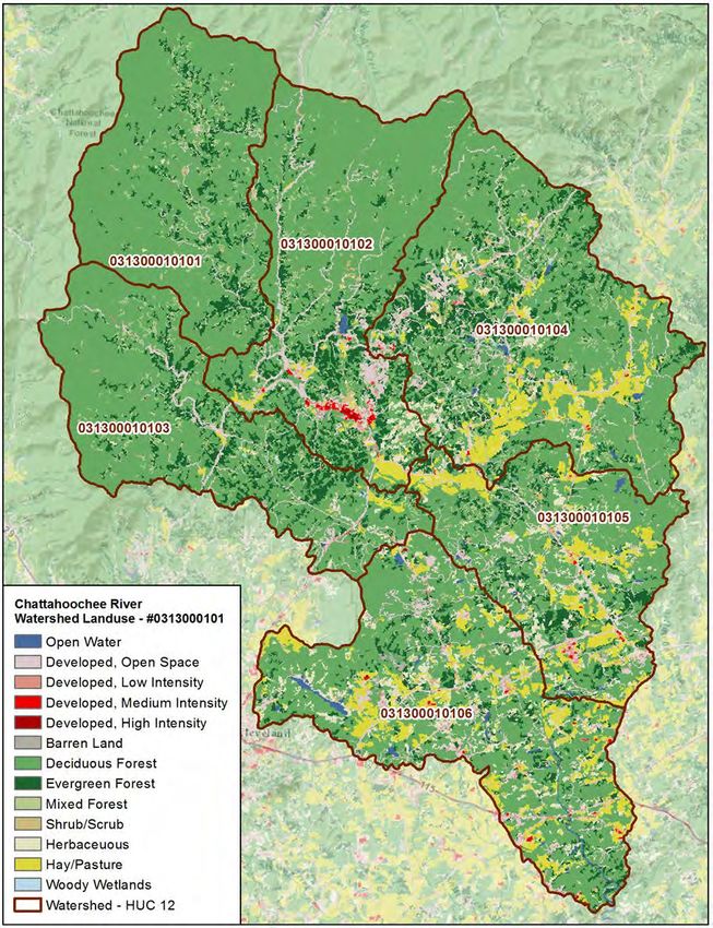
Upper Chattahoochee Watershed
                                                                      Watershed Management Plan - 2018

growth that do/may impact Georgia’s water quality, as well as providing a means for coordinating across
stakeholders how to monitor, improve and sustain healthy water.

As a watershed management plan (WMP), this document will follow EPD guidelines and standards in
addressing the water quality for the Chattahoochee River watersheds. It has been developed in
response to previous TMDL assessments that established a violation concern but did not fully establish a
source. By going through a watershed-based approach, this WMP provides an identification of likely
causes as well as recommended remediation measures for restoring and sustaining water quality within
the Chattahoochee River watershed.

As part of the watershed planning directed by EPD, documents such as this are to include the Nine Key
Elements (see below) as recommended by the U.S. Environmental Protection Agency (EPA). The nine
elements are recommended to ensure the propriety of the assessment, a minimum of stakeholder
involvement and to ensure a program of action for attaining watershed restoration objectives.

                            EPA’s Nine Key Elements for Watershed Plans

   1. An identification of the sources or groups of similar sources contributing to nonpoint source
      (NPS) pollution to be controlled to implement load allocations or achieve water quality
      standards.
   2. An estimate of the load reductions needed to de-list impaired stream segments;
   3. A description of the NPS management measures that will need to be implemented to achieve the
      load reductions established in the TMDL or to achieve water quality standards;
   4. An estimate of the sources of funding needed, and/or authorities that will be relied upon, to
      implement the plan;
    5. An information/education component that will be used to enhance public understanding of and
       participation in implementing the plan;
    6. A schedule for implementing the management measures that is reasonably expeditious;
    7. A description of interim, measurable milestones (e.g., amount of load reductions, improvement
       in biological or habitat parameters) for determining whether management measures or other
       control actions are being implemented;
    8. A set of criteria that can be used to determine whether substantial progress is being made
       towards attaining water quality standards and, if not, the criteria for determining whether the
       plan needs to be revised; and;
    9. A monitoring component to evaluate the effectiveness of the implementation efforts, measured
       against the criteria established under item (8) above.

PROJECT SCOPE

The Upper Chattahoochee Watershed is located predominantly in White County, Georgia, within the
upper Chattahoochee River Basin. Portions of the watershed feed into headwaters within Towns and
unions county immediately north of White County, in the Chattahoochee National Forest. An additional

                                                                                                      2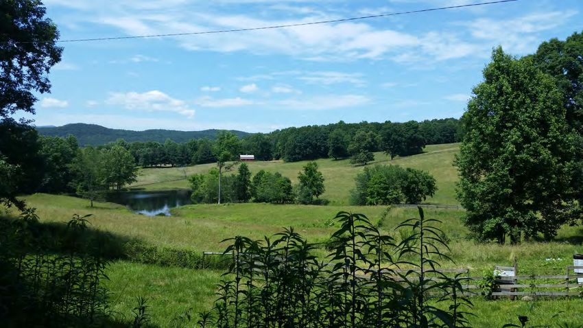
Upper Chattahoochee Watershed
                                                                        Watershed Management Plan - 2018

segment of the watershed lies to the east in Habersham County, encompassing the Soque Creek
watershed.

                                         The drainage area of the Upper Chattahoochee Watershed
                                         (HUC10 #0313000101) and is just under 100,000 acres and
                                         features 316 miles of perennial and intermittent streambeds
                                         plus almost 500 acres of lakebed. Significant tributaries include
                                         Smith Creek, which drains from Unicoi State Park downstream
                                         from Anna Ruby Falls, Dukes Creek just south of Helen, which
                                         receives water from the Smithgall Woods recreation area and
                                         traverses some agricultural land in the Nacoochee Valley, Blue
                                         Creek and Brasstown Creek, and the aforementioned the Soque
                                         River.

                                         According to the GAEPD’s 2014 Integrated 305(b)/303(d) List of
                                         Waters identifies one stream segment in the watershed as not
                                         meeting water quality standards for both biota impacted fish
                                         due to sediment (Bio F) and fecal coliform bacteria (FC), and a
                                         second segment as not meeting water quality standards for FC.

THE GMRC

This report was developed by the Georgia Mountains Regional Commission (GMRC). The GMRC is one
of 12 regional government offices within Georgia working to foster economic development and to
provide community planning and information services. The GMRC provides services and technical
assistance directly to its 13 counties and 38 municipalities as well as developing regional initiatives and
supporting the programs of various State Departments. Originally founded as the Georgia Mountains
Area and Planning Development Center in 1962, the GMRC has evolved in the common services
provided but continually works to assist its member governments in efforts that preserve local
character, encourage sustainable resource management and progressive economies, and contribute to
improving the overall well-being of the region and its communities.

Currently the GMRC employs 33 staff in the realms of planning, economic development, workforce
development, information technology, human resources and general administration. The Council for
the GMRC consists of two representatives from each county, one from the County Commission and one
mayoral representative from all the cities within that county, as well as 5 appointees from the State
legislature.

As the contractor for this project, the GMRC was responsible for carrying out the tasks and duties
necessary to complete this document, including but not limited to the following:

−   Outreach to local stakeholders;
−   Survey the watershed to identify possible causes/sources of pollution, as well as opportunities for
    remediation;
−   Produce the final WMP.

                                                                                                         3
Upper Chattahoochee Watershed
                                                                        Watershed Management Plan - 2018

                                          WATERSHED PROFILE

WATERSHED LOCATION AND GENERAL DESCRIPTION

The Upper Chattahoochee Watershed is located predominantly in White County, GA, located north of
Gainesville and including the City of Helen and portion of the City of Cleveland. This watershed features
the river’s headwaters which begin in the Chattahoochee National Forest and includes Unicoi State Park,
portions of Union and Towns Counties, and a segment of Habersham County to the east.

The headwaters come from the beginnings of the Appalachian Mountains, with the Chattahoochee River
proper originating in Union County, northwest of Helen. Collecting runoff from the steeper slopes the
myriad creeks and streams quickly come together such that within a couple miles it’s wide enough to
embody the river namesake near the Upper Chattahoochee River Campground. Here the terrain is
mostly wooded hillsides and mountain slopes, and for another 2 miles downstream the river will receive
the outflow from many other tributaries such as Wilks Creek and Low Gap Creek. Along this stretch runs
Chattahoochee Road and there are a few small houses to be found.

Eventually the Chattahoochee River merges with Spoilcane Creek alongside SR 17 just north of Helen, at
which point the river is typically 20+ feet wide and featuring varieties of low-grade whitewater, and less
than another mile downstream the river merges with Smith Creek from the east. At this point the river is
sometimes wider and noticeably stronger in current, but more importantly this is where the
Chattahoochee first becomes a large scale public attraction. Just north of the merger with Smith Creek
the river begins to host tourists riding tubes down into central Helen, with a variety of decks and public
overlooks lining the shore. The river is often shrouded in tree canopy but the shoreline vegetation itself
is typically broken by public access points and rocks designed to minimize erosion but maintain easy
views to the water. Local roads will traverse close to the river on either side for the most part. The river
will be like this through downtown Helen to the southern side of the city, where most tubers take out at
a local water park before the river passes by the City’s water treatment plant.

From here the river flows with less, but still some, interruption through the 2+ mile Nacoochee Valley
where the last vestiges of agricultural uses persist in this part of White County. The river turns east
flowing through the valley, picking up strength as more tributaries (namely Chickamauga Creek)
contribute to the flow. This area features the only notable concentration of pastureland or row crops
immediately adjacent to the river, though none of the operations in the valley are significant large scale
commercial farms. The total livestock counted on any given day might broach 100-150 large animals
across the valley, as most of the farms here are legacy properties, hobby farmers and residents keeping
a few animals for their own.

By the time the Chattahoochee exits the valley the river is anywhere from 40-60 feet wide and the
volume of whitewater has subsided for a spell. The river will wind through hillsides for the next several
miles, with variety of residential housing uses dotting the landscape as the watershed gets closer to
more suburban settings and the river is large enough to serve as an attraction to residents. Homes will
line either side of the river from here until State Highway 255

                                                                                                          4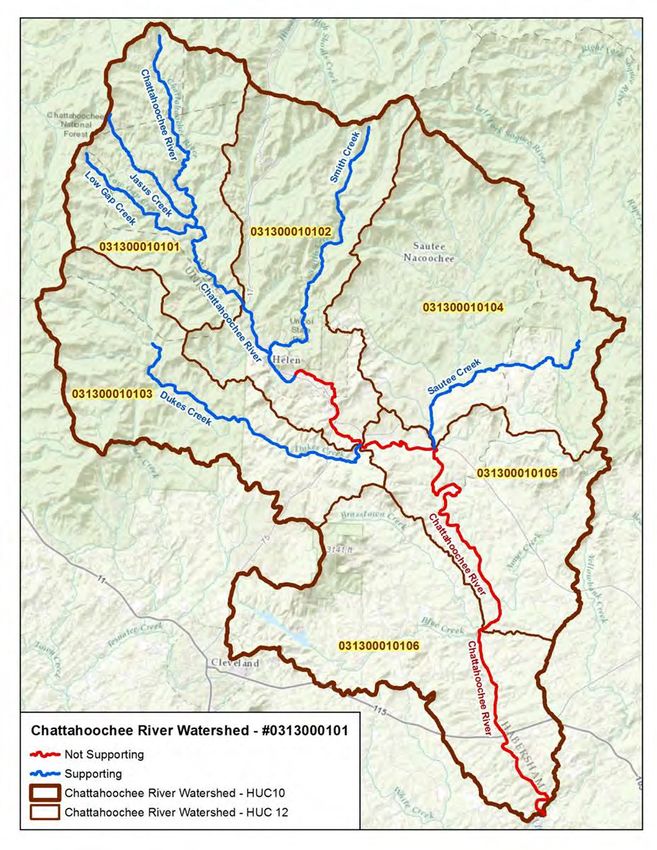
Upper Chattahoochee Watershed
                                                                       Watershed Management Plan - 2018

NATURAL FEATURES AND CONDITIONS

(Much of this material has been taken from, or referencing, existing or past editions of the White County
Comprehensive Plan)

Weather and Climate

The climate of White County is strongly influenced by mountainous terrain and the typically
northeastern-flowing drafts that drive moisture from the west. Summers are mild and winters are quite
cold. Generous precipitation occurs throughout the year with heavier amounts in winter and early
spring, and typically gives the local streams a dynamic temperature range for water bodies not fueled by
winter frost.

The complex terrain and contrasting elevations of White County creates highly variable weather
conditions. High elevation mountain areas are commonly 5 to 10 degree colder during the day than
valley bottoms. In the evening, cold air flows off of the high slopes into the valleys. In these bottom
lands, early morning temperatures can be 10 to 15 degrees colder than surrounding areas. Precipitation
varies as well. High elevations receive more rainfall and snow than lowlands, as air is forced to rise and
cool as it pushed over mountains. Elevation changes alone can increase annual precipitation by 10
inches or more, when compared to nearby lowlands. Microclimates at high elevations are common, and
lead to greater biodiversity than surrounding counties that have only low elevations.

The Southeast Regional Climate Center’s Clarkesville and Helen stations have weather and climate
records from 1961 to 2000. Maximum summer temperatures during this time averaged in the middle to
high 80’s. July is the warmest month, with the average highs of 86.5 degrees. Lows during the summer
are comfortable, and average between the high 50’s and low 60’s.

Average high temperatures during the winter months are in the low to middle 50’s. January is the
coldest month with an average high temperature of 50.9, and an average low temperature of 29.4.
Average low temperatures throughout the winter months range from the high 20’s to the high 30’s.
 Precipitation in White County follows a winter maximum regime with a second peak of precipitation
during summer months. In the Town of Cleveland, December through March are the wettest months,
during which time the city receives between 5.71 and 6.94 inches of precipitation per month. July and
August also see considerable rainfall. During these months, Cleveland receives a monthly average of
5.64 and 5.37 inches of rain. Snowfall can occur during winter months, especially at higher elevations.
Cleveland averages 2.6 inches a year while Helen’s average snowfall is 3.4 inches. The fall and early
summer are the driest periods. During this time, monthly precipitation averages between 4.24 and 5.19
inches of rain.

Physiography

White County lies within two physiographic provinces: the Blue Ridge District and the Piedmont District.
The north and northwest sections of the County are within the Blue Ridge Mountains District, which
consists of rugged mountains and ridges ranging in elevation from 3,000-4,700 feet. The southern
boundary of the Blue Ridge Province abuts the Piedmont Province at approximately the 1,700 ft.
elevation where a sharp contrast in regional slope occurs.

                                                                                                        5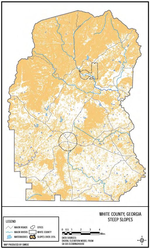
Upper Chattahoochee Watershed
                                                                         Watershed Management Plan - 2018

The portion of White County that falls within the Piedmont Province can be subdivided into three
different districts. A small middle-western portion of the County lies within the Dahlonega Upland
District, which is a rough and hilly section standing 1,500 to 1,700 feet above sea level. Streams in this
district flow south out of the Blue Ridge Mountains District and have cut deep, narrow valleys 500 to
600 feet below the surrounding surface. Running in a southwest to northeast direction in the southwest
and central portions of White County, at a width of approximately five miles, is the Hightower-Ridges
District. This district contains a series of low, linear, parallel ridges separated by narrow valleys. The
Hightower Ridges range in elevation from 1,000 feet in the southwest to1,500 feet in the northeast. The
remainder of White County (southern and eastern portions) lies within the Central Uplands District,
which encompasses a series of low, linear ridges 1,300 to 1,500 feet above sea level separated by broad,
open valleys. Streams flowing through this section occupy valleys 150 to 200 feet below the ridge crests.
(Source: Georgia Department of Natural Resources, Geologic and Water Resources Division. Physiographic Map of
Georgia. 1976.)

Land Cover

The mountain region of northeastern Georgia contains multiple climatic and soil conditions that
stimulate the growth of many trees and plants. The slopes, soils, and annual rainfall are principal
natural factors controlling the vegetation of the area, giving shape to the local ecosystem and conditions
impacting runoff.

The Upper Chattahoochee River watershed is a heavily wooded area that features rolling-to-steep hills
populated with varieties of pine, hickory, elm and other trees. Oak forests often predominate on the
eastern faces of the mountains, which do not typically receive as much moisture, while pines and oaks
may mix on some slopes. The northern facing slopes, which will be cool and moist, will be made up of
mostly broadleaf deciduous forests. At higher elevations, the understory is less varied. Shrubs of
mountain laurel and rhododendron form nearly impenetrable thickets that are densest where
conditions are wettest. The large amount of forested land in this region provides wildlife with shelter
from adverse weather and also gives protection from predators by providing screening or escape cover.

Within a forest community, how the plants grow in different layers is also an important type of
arrangement called vertical layering. This is important because some wildlife species may use the
ground layer vegetation (herbaceous) for food, but also need the tallest layer (tree canopy) for shelter.
The middle layer between the tree canopy and herbaceous layer is comprised of shrubs (shrub layer).
Every mature forest community has different vertical layering. Some may have a variety of layers
comprised of grasses, broadleaf weeds (forbs), shrubs, small trees, and large trees; whereas, others may
only have one distinct layer of tall trees. The latter would provide fewer habitats for wildlife compared
to the forest stand with a variety of layers. The boundary where 2 or more different plant communities
or successional stages (such as where a forest meets a pasture or cropland) meet is called edge.

There are also many areas that are open fields and pastureland as well. Small treeless openings that
provide breaks in tree canopy and provide leafy trees, shrubs, grasses, and flowering plants which
attract deer, rabbits, and mice. Berries and other fruits will draw birds and bears to the area, while
dozens of wildlife species are known to feed on nuts such as acorns, which would be prevalent on the
eastern faces of the mountains. The different species of herbivores will undoubtedly attract predators
such as coyotes, wolves, cougars and bears, which prey on other animals.

                                                                                                           6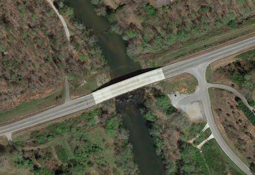
Upper Chattahoochee Watershed
                                                                          Watershed Management Plan - 2018

Wildlife is attracted to the many water resources in the area and will settle near streams and rivers for
drinking, bathing, and reproduction. Without a sufficient water source, wildlife must either leave the
area or die. Wild animals will not inhabit areas too far from water, even if food and cover are abundant.

                                    General Forest Types by Elevation.
         Forest Type                              Locale                               Elevation
 Oak Ridge                        Along crests of Blue Ridge                          3600-4000'
 Open Oak Pine                    Exposed north or south facing slopes                2100-3800'
 Mixed Deciduous                  Moist Valley Floors                                 1800-2000'
 Oak-Hickory-Pine                 Dry ridge slopes of Piedmont                        1800-2000'
Source: Institute of Community and Area Development, University of Georgia, The Atlas of Georgia. 1986.

Steep Slopes

Due to its location in the Blue Ridge and Piedmont Physiographic provinces, White County has a number
of mountains which pose limitations on development. A total of 34.87 percent (54,225 acres) of the
County area qualifies as steep slopes. The highest elevations in White County are located along the
northern county boundary with Lumpkin, Union, Towns, and Habersham Counties. This county line also
forms the Tennessee Valley Divide, which separates the Chattahoochee River Basin from the Tennessee
River Basin. The Tennessee Valley Divide contains some of the highest elevations in North Georgia, with
15 mountains in White County surpassing 3,000 feet.

The complex terrain of White County results in a significant area that is impacted by steep slopes. As
noted earlier, the greatest occurrence of steep slopes is found in the northern portion of White County.
The U.S. Forest Service’s Chattahoochee National Forest and a number of Wildlife Management Areas
already protect much of this area. Despite large areas of already protected land, steep slopes are
located throughout the area and need special consideration. Development on steep slopes can be
problematic because of issues relating to environmental quality and public health and safety. Steep
slope are generally composed of thin soils that are easily eroded. If development occurs on steep
slopes, eroded sediment enters streams and impacts surface water quality and aquatic habitat. Steep
slopes commonly contain distinctive natural settings because of high elevations, unique aspect to sun
angles, and other others that lend themselves to particular habitats of threatened or endangered
species. Environmental reasons aside, excessively steep slopes are also not suited for development.
Development has the potential to induce landslides, and the operational capability of septic drainfields
is reduced, and may create health and safety concerns for local residents. To some extent, a septic
system can overcome issues associated to steep slopes, but the system must be designed with slope
considerations in mind. The building permitting process is a useful measure in maintaining citizen’s
general welfare during development periods, and it should address septic placement on steep slopes.
Further, development on steep slopes creates accessibility problems for emergency vehicles and places
increased demands on infrastructure. For example, considerably larger pumps are mandatory to
overcome gravitational forces in order to supply water to sites located on steep slopes.

White County has worked to minimize development along mountain sides but some still occurs due to
the high demand (and subsequent political pressure) for housing with scenic views. Most of this
development has occurred around the Helen and Suatee areas, with dozens of legacy structures along
the slopes within the national forest.

                                                                                                          7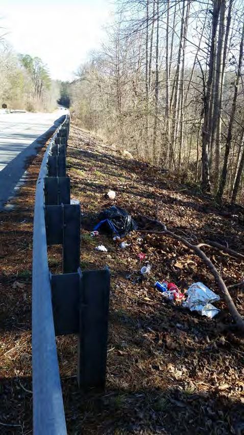
Upper Chattahoochee Watershed
                 Watershed Management Plan - 2018

Land Cover Map

                                               8
Upper Chattahoochee Watershed
Watershed Management Plan - 2018
9Upper Chattahoochee Watershed
Watershed Management Plan - 2018
Soil Types
An analysis of the types of soils in White County and their suitability for certain land uses is an important
component of the Comprehensive Plan. White County has a broad range of soils, which are listed by
symbol and name in Table 2-2, along with the limitations of each soil type on crop cultivation, dwelling
foundations, septic tank utilization, and commercial structures.
Of the 55 soil types in White County there are 17 soil types which have been identified (*) as suitable for
intensive crop cultivation. The soils most suitable for crop cultivation are found on lesser slopes (2-10%).
Most of the soils in White County have limitations for intensive crop cultivation because of steep slopes,
severe erosion hazards, flooding, low natural fertility, low organic matter content, shallow depth of
rooting zone, rock outcrops, and/or surface stones. Although only 17 soil types are found suitable for
intensive crop cultivation, other soil types can be and are cultivated for crops. Furthermore, many of the
soils not identified as suitable for intensive crop cultivation are suitable for other agricultural uses such
as pasture and woodlands. The vast majority of land areas in White County have soils which pose severe
limitations on dwelling foundations and septic tank utilization. The Masada soil association (MoB, MoB2,
MoC2, MoD2) is the most suitable soil for these uses. Approximately 28,190 acres, or 18% of the total
County land area, have only slight to moderate limitations on dwelling foundations and septic tank
utilization. Even less of the County land area has soils suited for commercial and light industrial uses
without extensive adjustments; approximately 26,365 acres, or 17% of the total County land area,
contain soils with only moderate limitations on commercial structures.
White County lies within the Upper Chattahoochee River Soil and Water Conservation District along with
Dawson, Forsyth, Hall, Habersham and Lumpkin Counties. Soil and water conservation districts were
formed in Georgia by 1957 with the purpose of providing local direction to federal conservation efforts.
In addition to basic duties such as coordinating programs and developing annual and long range plans,
the districts sponsor demonstration projects and conservation workshops. (Source: Georgia Soil and Water
Conservation Committee, Georgia Resource Conservation Program and Action Plan, 1982.)
Limitations of Soils in Development, 2006
Percentage of Total
White County Acres County Acreage
Total Hydric Soils 8,385 5.39 %
Total Prime Agricultural Soils1 28,655 18.43 %
Total Soils with 25% slope or more 54,225 34.87 %
Total Soils Suitable for Septic Tanks2 28,190 18.13 %
Total Soils Suitable for Commercial
26,365 16.95 %
Structures2
Notes: 1. Excludes the Cartecay Complex and Toccoa soil types, which is considered a hydric soil and,
therefore; not included as a prime agricultural soil.
2. With only slight or moderate limitations. Can be used with special management.
Source: U.S. Department of Agriculture, Soil Conservation Service. Soil Survey of Dawson,
Lumpkin and White Counties, Georgia. 1972.
10Upper Chattahoochee Watershed
Watershed Management Plan - 2018
Soil Types in White County as Identified in the USDA Soil Conservation Service Soil Survey
Foundation Suitability Septic % of
(% Suit- County
Symbol Soil Name Slope) Housing Commercial ability Acreage
AcG As he stony loam (60-90) Se Se Se
AEE Ashe/Edneyville stony loam (10-25) Se Se Se
AEF Ashe/Edneyville stony loam (25-60) Se Se Se
AmC2* Appling sandy loam (6-10) Sl M M
AWB** Augusta fine sandy loamy (2-6) Se Se Se
AwC Augusta fine sandy loam (6-10) Se Se Se
Bfs Buncombe loamy sand Se Se Se
BvF Burton loam (15-50) Se Se Se
Cac** Cartecay complex Se Se Se
CCF Chandler loam (25-60) Se Se Se
Con* Conagree/Starr soils Se Se Se
EPD Edneyville/Porters loams (10-15) M Se M
EPE Edneyville/Porters loams (15-25) Se Se Se
EPF Edneyville/Porters loams (25-60) Se Se Se
EPG Edneyville/Porters loams (60-80) Se Se Se
FaB* Fannin fine sandy loam (2-6) Sl M M
FaC* Fan n in fine sandy loam (6-10) Sl M M
FaE Fannin fine sandy loam (10-25) MtoSe Se Se
FbC2* Fannin sandy clay loam (6-10) Sl M M
FbE2 Fannin sandy clay loam (10-25) Se Se Se
FcF Fannin soils (25-60) Se Se Se
Gut Gullied land Not Rated
HIB* Hayesville sandy loam (2-6) Sl M M
HIC* Hayesville sandy loam (6-10) Sl M M
HIE Hayesville sandy loam (10-25) MtoSe Se Se
HJC3* Hayesville sandy clay loam (6-10) Sl M M
HJE3 Hayesville sandy clay loam (10-25) Se Se Se
HKC3 Hayesville/Rabun clay loam (6-10) Sl M M
HLC* Hayesville/Rabun loams (6-10) Sl M M
HLD Hayesville/Rabun loams (10-15) M Se Se
HLF Hayesville/Rabun loams (25-60) Se Se Se
HSC* Hiwassee loam (2-10) Sl M SItoM
HSD* Hiwassee loam (10-15) M M M
HSF Hiwassee loam (15-40) Se Se Se
MCE Musella cobbly loam (6-25) Se Se Se
MCG Musella cobbly loam (25-70) Se Se Se
MoB* Masada fine sandy loam (2-6) Sl M Sl
MoB2* Masada fine sandy loam (2-6) Sl M Sl
MoC2* Masada fine sandy loam (6-10) Sl M Sl
11Upper Chattahoochee Watershed
Watershed Management Plan - 2018
Foundation Suitability Septic % of
(% Suit- County
Symbol Soil Name Slope) Housing Commercial ability Acreage
MoD2* Masada fine sandy loam (10-15) M Se M
MuE2 Musella gravelly clay loam (10-25) MtoSe Se Se
RaE Rabun loam (15-25) M Se Se
RbD3 Rabun clay loam (10-15) M Se M
RbE3 Rabun clay loam (15-25) Se Se Se
Sta* Starr fine sandy loam Se Se Se
TbE Tallapoosa cobbly fine sandy loam (6-25) Se Se Se
TcE Tallapoosa fine sandy loam (10-25) MtoSe Se Se
TdG Tallapoosa soils (25-70) Se Se Se
TIC* Tusquitee loam (6-10) Sl M Sl
TID Tusquitee loam (10-25) MtoSe Se MtoSe
TIF Tusquitee loam (25-60) Se Se Se
TmE Tusquitee stony loam (10-25) Se Se Se
TmF Tusquitee stony loam (25-60) Se Se Se
Toe*
(**) Toccoa soils (0-2) Se Se Se
Wed** Wehadkee soils (0-2) Se Se Se
WgC* Wickham fine sandy loam (6-10) Sl M Sl
WgD Wickham fine sandy loam (10-25) MtoSe Se MtoSe
WgF Wickham fine sandy loam (25-50) Se Se Se
WnD3 Wickham sandy clay loam (10-15) M Se M
Notes: * Suitable for farming (cultivated crops).
** Hydric soils, according to Soil Conservation Service.
Se Severe limitations, extensive adjustments are needed before suitable for purpose.
M Moderate limitations, some adjustment needed for use.
Sl Slight limitations, little or no adjustments needed for use.
Soil Suitability for Dwelling Foundations, Septic Tank Absorption Fields and Commercial Structures
White County has limited opportunity for most structure types due to the steep terrain, but even more
restrictions apply in areas with unsuitable soil and substrata. As a result the county’s basins and bottom
lands tend to be in full use where possible. The Chattahoochee River watershed exhibits some
comparably mild topography and some agricultural activity as a result, but there are not many places
ideal for large scale, heavy construction due to soil and other factors. Most of the commercial and
industrial activity has thus been directed toward hill tops in and around Cleveland.
12Upper Chattahoochee Watershed
Watershed Management Plan - 2018
Septic Tanks and On-Site Sewage Structures
Of primary concern to the area is the environmental sensitivity to on-site septic systems, particularly
older models or those that have not been properly maintained. Less than 20% of White County is
categorized as suitable for handling septic waste filtration, yet even where the soils are conducive to this
use the general topography and/or proximity to surface water may curtail that option. Soil Erosion
White County has adopted ordinances which reflect the required provisions of the Georgia Erosion and
Sedimentation Act of 1974 dealing with construction and development site soil erosion and
sedimentation. In order for any local government to become or remain a certified local issuing authority
for an erosion and sedimentation control permit (also known as a grading permit), the local government
must first adopt an ordinance, which demonstrates compliance with the provisions in O.C.G.A. 12-7-1.
The County does not keep records that track total septic tank service repairs or replacements, and calls
about possible violations are sometimes only made when neighboring property owners discover the
leaky or faulty system. With many houses in the area older than 1990 it is presumed a significant
portion of septic systems in the county are not only not matching modern performance standards but in
need of maintenance in their own right, if not outright replacement. Compounding the matter might
also be the number of systems that are subject to higher-then-normal volumes during tourist seasons
when many properties host larger gatherings, as some tanks and drain lines are not equipped to handle
seasonal fluctuations. Such issues may place undue burdens on the local soils to receive and treat septic
wastewater.
Prime Agricultural and Forested Lands
"Prime farmland" in Georgia is land which is best suited for producing food, feed, forage, fiber, and
oilseed crops, and also available for these uses. It has the soil quality, growing season, and moisture
supply necessary to produce sustained good yields of crops economically if treated and managed,
including water management according to modern farm methods.
From the list of soils found in Lumpkin County, 17 soils types have been identified as prime agricultural
soils. There are scattered fragments of prime agricultural soils throughout the county but, due to the
prevailing topography of the area limited concentrations of such soils in lands conducive to farming.
There are no major commercial farming operations for livestock or row crops, and with the growing
popularity of the mountains for forest-based recreation and scenery, the area has not been reserved or
designated as prime agricultural territory.
13Upper Chattahoochee Watershed
Watershed Management Plan - 2018
14Upper Chattahoochee Watershed
Watershed Management Plan - 2018
Mineral Resources
White County has a variety of mineral resources. Two areas within the County contain granite and
related rock outcrops: One area in the mid-northwest section; and one area in the extreme northeast
portion of the County. An area of gold deposits, approximately four miles wide by fifteen miles long,
bisects the central portion of White County running southwest to northeast in the same general pattern
as the Hightower Ridge. This area is known as the "Dahlonega Belt". Paralleling the span of gold deposits
to the south is a broken concentration of granite and related rocks. There is also a concentration of mica
(colored or transparent mineral silicates that separate into thin leaves and used dry in roofing materials,
joint cement, well drilling compounds and paint) located east of SR 75 and north of SR 254.
Other mineral resources found in lesser quantities in White County are: corundum (a very hard mineral
that consists of aluminum oxide and which is used as an abrasive); feldspar (crystalline minerals
consisting of aluminum silicates which is ground and used in the manufacture of glass, pottery, enamels
and abrasives); iron and manganese; sulfide deposits (iron, copper, etc.); talc (a soft mineral that is a
basic magnesium silicate and which is used as a filler in rubber); asbestos (a mineral supposed to be
inextinguishable when set on fire, used for chemical filters and plastics); sillimanite (a mineral consisting
of aluminum silicate which has uses in the production of high temperature refractories); quartzite (a
compact granular rock composed of quartz and derived from sandstone); and soapstone (a soft stone
having a soapy feel and composed of talc, chlorite and magnetite). (Sources: Georgia Department of Mines,
Mining and Geology, The Common Rocks and Minerals of Georgia. Information Circular No. 5,1934, Revised 1964.
Georgia Department of Natural Resources, Georgia Geologic Survey, Mineral Resources Map. 1969.)
A deposit study of mineral deposits in White County was completed in 1964. This study concluded,
among other things, that the "volume and grade of gravels in the Nacoochee Valley, Sautee Creek, Bean
Creek and Dukes Creek warrant a dredging operation," and that "other economic materials which might
be worked are asbestos, mica and soapstone."
Although there are a variety of mineral resources located in White County, mining and quarrying
operations are limited to fill material, gold and sand-construction commodities.
Plant and Animal Habitats
Georgia's Protected Species Program began in 1973 with the enactment of two state laws: the
Endangered Wildlife Act and the Wildflower Preservation Act. These laws provide protection for certain
species of plants and animals. Under the Natural Heritage Inventory Program, the Georgia Department
of Natural Resources is continuously in the process of completing an inventory of rare plants, animals
and natural habitats in Georgia warranting state and federal protection.
According to a report by the Georgia Department of Natural Resources, the natural environment of
White County is conducive to three (3) species of protected wildlife and eight species of concern.
Threatened Species:
• Bluestripe Shiner (Cyprinella callitaenia)- This threatened fish is found only in the
Chattahoochee Watershed and prefers flowing areas in large creeks and medium sized rivers
over rocky substrates.
15Upper Chattahoochee Watershed
Watershed Management Plan - 2018
• Highscale Shiner (Notropis hypsilepis)- This threatened shiner prefers habitats of streams
flowing over sand or bedrock substrates.
• Northern Pine Snake (Pituophis melanoleucus melanoleucus)- This threatened snake grows to
between 48 and 68 inches and is identified by its black and dull white to yellowish or light grey
color. It is found in dry pine or pine-hardwood forests.
Species of Concern:
• Coal Skink (Eumeces anthracinus)- This lizard grows from 5 to 7 in. in length and can be found in
mesic forests near streams, springs or bogs.
• Blue Ridge Two-lined Salamander (Eurycea wilderae)- This small salamander is distinctive
because of its two stripes that run the length of its body, but break apart into spots that cover
its tail. The Blue Ridge Two-lined Salamander is found in high elevation springs and seeps that
are adjacent to hardwood forests.
• Four-toed Salamander (Hemidactylium scutatum)- This salamander, as the name implies, has
four toes instead of the common five toes on the hind feet. The four toed salamander is found
in swamps and boggy streams and ponds, located near hardwood forests.
• Greater Jumprock (Scartomyzon lachneri)- The Greater Jumprock is a sucker that can be found in
small to large streams in swift current over rocky substrate.
• Masked Shrew (Sorex cinereus)- This shrew has a dark gray coat, with lighter gray underbelly.
The Masked Shrew can be found in high elevation mesic forests, field edges, swamps, or
mountain bogs.
• Pygmy Shrew (Sorex hoyi)- The Pygmy Shrew’s habitat includes mountain bogs and grassy
openings in high elevation forests. It is an insectivore that grows up to two inches in length.
• Red Squirel (Tamiasciurus hudsonicus)-
• The Diana Fritillary (Speyeria Diana)- is a colorful butterfly whose habitat includes openings and
fields in wet, rich, forested valleys and mountainsides.
Fish are also an important part of wildlife in the mountains. The cold-water streams support rainbow,
brown and brook trout, of which only the brook trout species is native to the State of Georgia. The
Department of Natural Resources maintains listings of primary and secondary trout streams. Primary
trout streams have environmental conditions that are most favorable for trout, and the trout are able to
both survive and reproduce in these waters. In secondary trout streams, trout are able to survive
without assistance but are unable to reproduce naturally, and thus require stocking to maintain their
populations. Trout are commonly used as indicator species because of their sensitivity to environmental
changes such as sedimentation, insect populations, and water temperature. The State of Georgia
protects trout streams through the Erosion and Sedimentation Act, which provides a 50-foot stream
buffer on all trout streams with an average annual discharge of greater than 25 gallons per minute. A
25 foot buffer is applied to all streams with an annual discharge of less than 25 gallons per minute. In
White County, primary trout streams include: the Cathey Creek watershed upstream from the
Arrowhead Campground Lake, the Chattahoochee River watershed upstream from Georgia Hwy.255
Bridge, and the Town Creek watershed upstream from the mouth of Jenny Creek. Secondary trout
streams include: the Chattahoochee River watershed upstream from the Georgia Hwy.115 to the
16Upper Chattahoochee Watershed
Watershed Management Plan - 2018
Georgia Hwy.255 Bridge, the Little Chestatee River watershed upstream from the mouth of Turner
Creek, and the Turner Creek watershed (except those sections listed as primary trout streams).
The mountain region of North Georgia contains a multiplicity of climatic and soil conditions that
stimulate the growth of many trees and plants. The slopes, soils, and annual average rainfall are
principal natural factors controlling the vegetation of the area. These varied natural conditions have led
to habitat for numerous plant species with federal or state protection which include:
• Biltmore Sedge (Carex biltmoreana)- This perennial grass like herb is found at high elevations on
seepy cliff crevices in partial shade to full sun at high elevations. Notable features include its
stout, britte, scaly stolons and its narrowly tapered, bluish green drooping leaves.
• Manhart’s Sedge (Carex manhartii)- This perennial grass like herb can be fouind in loose clumps
with leafy shoots. Commonly found at elevations ranging from 2,000 to 4,000 ft, this plant
prefers the acidic soils of cove hardwoods.
• Pink Ladyslipper (Cypripedium acaule)- The Pink Ladyslipper is a perennial herb that is known for
its showy flower and pair of basal leaves, and is found acidic soils of pinelands, rhododendron
thickets, and mountain bogs.
• Large-flowered Yellow Ladyslipper (Cypripedium parviflorum var. pubescens)- This small
perennial has small white leafy stems and elliptic leaves with 1 to 2 yellow flowers. This Yellow
Ladyslipper prefers upland oak-hickory-pine forests and mixed hardwood forests.
• Florida Torreya (Torreya taxifolia)- This small evergreen tree can be found beneath magnolia
forests and mixed hardwood forests on middle to steep slopes with permanent seepage.
Species of Concern:
Sweet-fern (Comptonia peregrina) A Moss (Hypnum cupressiformen var. filiforme)
Butternut (Juglans cinerea) Broadleaf Bunchflower (Melanthium latifolium)
Minniebush (Menziesia pilosa) American Ginseng (Panax quinquefolius)
Naked-fruit Rush (Juncus gymnocarpus) Dwarf Ginseng (Panax trifolius)
Climbing Fern (Lygodium palmatum) Staghorn Sumac (Rhus typhina)
Wild Coffee (Triosteum aurantiacum) Woodland Bulrush (Scirpus expansus)
Habitats of Concern:
The Georgia DNR has also identified the Shrub Bald and Heath Bald as threatened natural communities.
These areas are located on the highest of peaks in Georgia including Tray Mountain, Brasstown Bald,
Standing Indian, and Blood Mountains. These balds are composed of a wide variety of plants including
Catawba rhododendron, mountain ash, and dwarf willow. A GAP analysis performed by the US
Geological Survey Biological Resources Division identified only 281 acres of Heath Bald in Georgia
(Source: Georgia Department of Natural Resources, Game and Fish Division. Georgia's Protected Species.)
Efforts are being made to protect the rare, endangered and protected species of plants in Georgia.
Public and private groups such as the University of Georgia and the Georgia Plant Conservation Alliance
are studying and attempting to preserve rare plants and attempting to return them to their original
landscapes. Even with these efforts though, rare species continue to be lost for many reasons, including
17Upper Chattahoochee Watershed
Watershed Management Plan - 2018
the drying of wetlands and heavy growth of rhododendrons, mountain laurel and other shrubby plants
that shut out light and inhibit reproduction (Source: Georgia Conservation Alliance).
Wetlands and Floodplains
Wetlands are those areas inundated or saturated by surface or groundwater at a frequency and
duration sufficient to support, and that under normal circumstances do support, a prevalence of
vegetation typically for life in saturated soil conditions. Wetlands generally include swamps, marshes,
bogs and similar areas. The ecological parameters for designating wetlands include hydric soils,
hydrophytic vegetation and hydrological conditions that involve a temporary or permanent source of
water to cause soil saturation. Fresh water wetlands and aquatic habitats are classified into the
following categories:
• Open water - Areas of open water, primarily reservoirs, ponds, lakes, rivers, and estuaries.
• Non-Forested Emergent Wetlands - freshwater marshes dominated by a variety of grasses,
sedges, rushes, and broad leaved aquatics associated with streams, ponded areas, and tidally-
influenced non-saline waters.
• Scrub/Shrub Wetlands - non-forested areas dominated by woody shrubs, seedlings, and saplings
averaging less than 20 feet in height, these wetlands may intergrade with forested wetlands,
non-forested emergent wetlands, and open water.
• Forested Wetlands - natural or planted forested areas having a dominant tree crown closure or
hardwoods, pines, gums, cypress, or any combination of these types. These areas are usually in
stream or river floodplains, isolated depressions, and drainways, and contain standing or flowing
water for a portion of the year.
• Altered Wetlands - areas with hydric soils that have been denuded of natural vegetation and put
to other uses, such as pastures, row crops, etc., but that retain certain wetland functions and
values.
Major Wetland Values.
Socio-Economic Values Environmental Quality Values
• Flood Control • Water Quality Maintenance
• Wave Damage Protection • Pollution Filter
• Erosion Control • Sediment Removal
• Groundwater Recharge & Water Supply • Oxygen Production
• Timber & Other Natural Resources • Nutrient Recycling
• Energy Source (peak) • Chemical & Nutrient Absorption
• Livestock Grazing • Aquatic Productivity
• Fishing & Shellfishing • Microclimate Regulator
• Hunting & Trapping • World Climate (ozone layer)
• Recreation • Fish & Shellfish Habitat
• Aesthetics • Waterfowl & Other Bird Habitat
• Education & Scientific Research • Other Wildlife Habitats
Source: American Planning Association, Planning Advisory Service. 1988. Protection of Non-Tidal Wetlands.
(Report Number 412/413).
18Upper Chattahoochee Watershed
Watershed Management Plan - 2018
Vegetation Common to Non-Tidal Wetlands.
Type of Wetland Vegetation
Emergent Wetlands: cattails, wild rice, sedges, rushes, bulrushes, spikerushes, burreeds, rice
Freshwater cutgrass, maidencane, reed, arrowheads, pickerelweed, smartweeds,
bluejoint, whitetop, reed cannary grass,manna grass, asters, goldenrod,
marsh fern
Pocosins Pond pine, sweet bay, inkberry, fetterbush, titi, red bay, was myrtle
Others Buttenbush, alders, willows, dogwoods, red maple sapplings, cottonwood
sapplings
Source: American Planning Association, Planning Advisory Service. 1988. Protection of Non-Tidal Wetlands.
(Report Number 412/413).
There exist three sources for determining the location of wetlands, one of which is the identification of
"hydric" soils. Hydric soils are a key indicator of potential wetlands. White County contains 5 hydric
soils, which are found throughout the county.
If the wetlands identified in the future land use plan are retained as open space and are protected in
accordance with the Environmental Planning Criteria, then no adverse effects are anticipated on the
public health, safety and welfare, or the property of others; no known unique or significant flora or
fauna, including threatened, rare or endangered species will be impacted; no adverse effects will occur
on the flow or quality of water or cause substantial additional soil erosion; no adverse impacts on
adjacent natural areas are likely to occur.
According to Federal Emergency Management Agency (FEMA) records, White County entered the
National Flood Insurance Program (NFIP) in 2000. Flood plains located in White County are illustrated
on the following map and on the Future Land Use Map as parks, recreation and conservation. Currently
the local Floodplain Protection Ordinance applies to all FEMA-mapped flood plains and structures
located in flood plains. In the near future, flood plains in White County will be remapped and updated
under a program called Map Modernization.
19Highway 75 N
56
y3
h wa
Hig
Highway 255 N
NM
ain S
t (He
len)
SM
ain
St
(He
len
)
Alt
H
75
ig
h w
ay
ay
hw
17
Hig
Hi
gh
wa
y1
29
y
N
Hw
len
D un
He
c an
Brid
ge
Rd
S
55
y2
h wa
Hig
N
M
ain
St
(C
le
ve
lan
W Kytle St
d)
E Ky
tle S
t
leveland)
Hig
hw
ay
115
S Main St (C
E
115 W
Highway
Highw
a y 12
9S
y 284
254
Highwa
ay
hw
Hig
Data Sources: Wetlands: US FWS- National Wetlands Inventory; Water Supply Watershed: GA DNR/EPD- Water Supply Watershed Maps;
Flood Hazard Areas: FEMA- 2002 FIRM; Groundwater Recharge Areas: GA DNR/EPD- Digital Environmental Atlas of Georgia; Mountain and Hillside Protection Areas: White County Mapping Dept.
Legend
Prepared by White County Mapping
Wetlands Streams State Hwy October 16, 2007
White County
8
Water Supply Watersheds Lakes County Roads Information depicted herein is for reference purposes
Environmentally Flood Hazard Areas City Limits City Roads only and is compiled from best available sources.
White County makes no warranty, expressed or implied,
Groundwater Recharge Areas County Boundary Private Roads concerning its accuracy or completeness and users
Sensitive Areas Mountain and Hillside Protection Areas US Hwy Forest Service
are advised that thier use of County data is at their own risk.
0 1 2 3 4 5 Miles
Public LandsUpper Chattahoochee Watershed
Watershed Management Plan - 2018
ANTHROPOGENIC FEATURES
Governmental Boundaries
The watershed is almost exclusively within White County. Minor portions of the headwater basin lie
within Union and Towns County to the north, with almost no development in these portions due to the
National Forest conditions and limited accessibility. Another sliver of the watershed, almost exclusively
within the Sautee Creek portion, is within western Habersham County. The rest of the watershed
encompasses almost the whole northern and eastern portions of White County, including all of the City
of Helen and parts of the City of Cleveland.
Land Use and Development
As discussed in the land cover and physiography sections, this watershed is predominantly undeveloped
and covered with varieties of forests and wooded areas. The vast extent of development within this
part of the region is sparsely populated, rural agrarian homesteads and some supporting uses. Farms
are prevalent but the terrain and slopes make commercial scale agriculture a difficult proposition.
Similarly, fields available for livestock are neither large nor available in volume.
A review of aerial imagery suggests there are possibly as many as 30+ poultry houses within the
watershed, though it is considered likely some of those structures are in disrepair and/or not in
operation. There is one property along GA 255 near the southern end of the watershed that appears to
have as many as 20 poultry structures, including some within 500’ of the river. Observations from
outside the property did not find evidence of concentrated dump sites for litter, nor has anyone
suggested the property has had pollution issues in the past.
There were several small farms in the area harboring (predominantly) cattle, horses, or goats. Only two
cattle farms, one near Helen and the other near 255 and Sautee Creek, had the volume of livestock to
suggest an active commercial operation. Both of these farms appeared to have fencing around local
streams and some drinkers were found on site, but there were portions of the farm fields that were not
visible from main roadways. Neither of these farms has been cited in the recent past for concerns over
violations according to local officials.
The most common structures within the Upper Chattahoochee watershed are homes and supporting
farm buildings, such as sheds and barns. In some of the more tourist oriented areas such as Helen and
Sautee these homes can be densely packed and close to the river or streams. As you move southward
the homes become more suburban and rural in density and form, with more and more properties taking
on larger, rustic settings for households looking for a country lifestyle. Topography does tend to keep
some houses near stream banks, and in portions of the Sautee valley some rural roads and driveways
will often follow along streams in an effort to minimize grading and clearing.
The population and location of the area does feature some urbanized and heavier commercial areas.
There are a dozen or more churches and a small variety of commercial structures of differing sizes. Most
are modest in scale and with limited impervious surfaces. Within the cities, however, are true urban
areas with densely packed structures and surface parking. Particularly around Helen this level of
development is growing as the City and the Sautee Nacoochee areas grow in popularity.
21Upper Chattahoochee Watershed
Watershed Management Plan - 2018
Upper Chattahoochee Watershed Land Cover Based on the
Acres Percent preliminary review of
Deciduous Forest 65,858 66.20 % land use and
development,
Evergreen Forest 11,145 11.20 %
suggested possible
Hay/Pasture 6,264 6.30 %
causes of increased
Developed, Open Space 6,195 6.23 % levels of fecal coliform
Mixed Forest 4,029 4.05 % into the water include:
Herbaceuous 3,591 3.61 % human waste from
Shrub/Scrub 783 0.79 % sewage leaks or septic
Developed, Low Intensity 574 0.58 % tank leaks, development
Open Water 498 0.50 % activities, logging
Barren Land 242 0.24 % activities, domestic
animals, urban wildlife,
Developed, Medium Intensity 187 0.19 %
livestock, or rural
Woody Wetlands 78 0.08 % wildlife.
Developed, High Intensity 36 0.04 %
*=Urban, recreational; e.g.
Total Acres 45,722 17,888
parks, lawns
Utilities and Infrastructure
Limited portions of the Upper Chestatee Watershed, mainly those in and around the cities or Helen and
Cleveland, have access to public sewer and public water. The two seasonal residential developments
that provide package systems of their own are adjacent to Helen. All of the remaining properties within
the Upper Chattahoochee watershed rely on wells and septic systems of some kind.
Environmental Interests and Other Organizations
The US Forest Service (UFSF) manages the Chattahoochee National Forest within Georgia, which
includes the Chestatee Wildlife Management Area and the Desoto Falls National Forest areas within
Lumpkin County. Combined these represent the bulk of the preserved woodland in the northeastern
part of the county, and are addressed within the USFS’ 2004 Land and Resource Management Plan for
the Chattahoochee and Oconee National Forests. This document guides the federal efforts to protect
the local ecology and environmental resources as well as providing visitor access to area camp sites,
hiking trails and scenic areas. This document is currently undergoing an update and is routinely shared
with local governments as well as being made available to citizens on the USFS web site.
As part of their involvement with the management of the Chattahoochee the Georgia EPD has
monitored stream data for the river and other tributaries via their own sampling stations. The sites have
changed over the years and the data for each does not always include bacterial monitoring, as it may be
used to gauge the relative flow, temperatures and clarity of the river, and to provide early indications of
needs for additional testing.
22Upper Chattahoochee Watershed
Watershed Management Plan - 2018
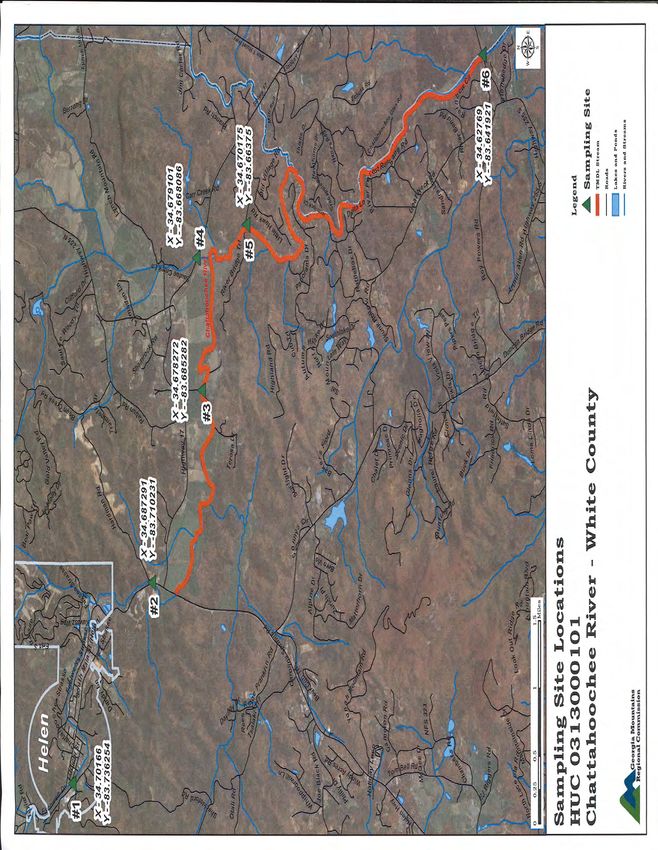
Upper Chattahoochee River Basin
Latitude
Name Station Id HUC Longitude
Chatahoochee River RV_12_4286 31300010101 34.733893
nr Chattahoochee River Rd nr Helen, GA -83.77755
Chattahoochee River RV_12_3982 31300010102 34.712778
Georgia Highway 356 -83.746111
Chattahoochee River RV_12_3984 31300010102 34.6872
at State Roads 17/75 near Nacooche, GA -83.710278
Smith Creek RV_12_3981 31300010102 34.735
Road Upstream From Lake, Unicoi Park -83.7225
Smith Creek RV_12_3983 31300010102 34.709722
Georgia Highways 17 and 75 -83.740556
Dukes Creek RV_12_4294 31300010103 34.69374
nr R B Russel Scenic Hwy (SR348) nr Helen -83.777643
Dukes Creek RV_12_3986 31300010103 34.671944
Georgia Highway 75 -83.713889
Sautee Creek RV_12_3987 31300010104 34.678889
at SR17/255 (Sky Lake Rd.) near Helen, GA -83.668333
Chattahoochee River RV_12_3985 31300010105 34.678217
at Bottom Road near Helen, GA -83.685579
Chattahoochee River RV_12_3988 31300010105 34.6275
Georgia Highway 225 -83.642222
Chattahoochee River RV_12_3989 31300010106 34.576944
at State Road 115 near Leaf, GA -83.635833
None of the records from these stations show fecal coliform monitoring more recent than 2010. Much
of the data suggests a possible link between rain flows and bacterial counts based on the occassional
spikes far beyond normal levels, with most of the data from the early 2000’s. Some of this information
has contributed to the the original TMDL and subsequent TMDL Implementation Plans.
Lying within the Chattahoochee River Basin, the watershed also part of the stream netowrk monitored
by the Chattahoochee Riverkeeper. As stated on their web site, the “Chattahoochee Riverkeeper’s
mission is to advocate and secure the protection and stewardship of the Chattahoochee River, its
tributaries and watershed, in order to restore and preserve their ecological health for the people and
wildlife that depend on the river system. Established in 1994, Chattahoochee Riverkeeper is an
environmental advocacy organization with more than 7,000 members dedicated solely to protecting and
restoring the Chattahoochee River Basin — drinking water source for nearly four million Georgians.
Chattahoochee Riverkeeper was the 11th licensed program in the international Waterkeeper Alliance,
now close to 200 organizations strong.”
As the foremost advocacy organization in the Chatthoochee basin, the Riverkeeper has supported
monitoring exercises, eduicational forums and water quality grants for various streams within the basin.
According to interviews with Riverkeeper staff they have not done any recent on-the-ground projects
within the upper Testnatee watershed within the past several years but would be available to assist in
the future.
23You can also read