MOUTOHORĀ (WHALE ISLAND) WILDLIFE MANAGEMENT RESERVE ECOLOGICAL RESTORATION PLAN 2014-2024 - DOC
←
→
Page content transcription
If your browser does not render page correctly, please read the page content below
Moutohorā (Whale Island)
Wildlife Management Reserve
ecological restoration plan
2014–2024
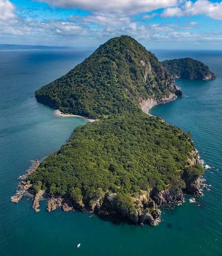
Cover: Moutohorā (Whale Island) Wildlife Management Reserve. Photo: David Finn.

© Copyright October 2016, New Zealand Department of Conservation

Published by Opotiki Office, Department of Conservation, PO Box 326, Opotiki 3162, New Zealand.
CONTENTS

1.    Introduction                                            1

2.    Moutohorā (Whale Island) Wildlife Management Reserve    3

      2.1    Geography                                        3
      2.2    Climate		                                        3
      2.3    Geology and landscape                            4
      2.4    Soils		                                          4
      2.5    Mammalian pest eradication                       4

3.    Flora		                                                6

      3.1    Forest structure and revegetation               6
      3.2    Threatened plant reintroductions                 8

4.    Invertebrates                                          10

5.    Reptiles                                               12

      5.1    Tuatara		                                       12
      5.2    Lizards		                                       14

6.    Avifauna                                               17

      6.1    Seabirds                                        17
      6.2    Kiwi		                                          20
      6.3    Tīeke		                                         21
      6.4    Kākāriki                                        23

7.    Marine mammals                                         24

      7.1    New Zealand fur seal                            24

8.    Control of pest plants                                 26

9.    Control of avian pests                                 28

      9.1    Southern black-backed gulls                     28
      9.2    Rock pigeons                                    29

10.   Contingencies                                          31

      10.1   Fire		                                          31
      10.2   Biosecurity                                     32

11.   Summary of tasks                                       33

12.   Acknowledgements                                       36

13.   References                                             36
Appendix 1

     Vascular flora of Moutohorā (Whale Island) Wildlife Management Reserve                              40

Appendix 2

     Vegetation and cover class map of Moutohorā (Whale Island) Wildlife Management Reserve              48

Appendix 3

     Map and table of vegetation monitoring plot sites in Moutohorā (Whale Island) Wildlife Management
     Reserve		                                                                                           49

Appendix 4

     Reptile species list for Moutohorā (Whale Island) Wildlife Management Reserve                       51

Appendix 5

     Avifauna species list for Moutohorā (Whale Island) Wildlife Management Reserve                      52

Appendix 6

     Tīeke (Philesturnus carunculatus) transect lines                                                    54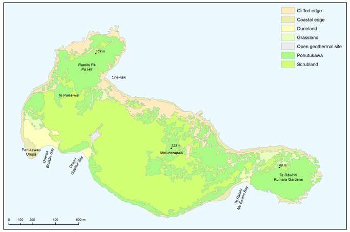
Moutohorā (Whale Island) Wildlife
		 Management Reserve ecological
		 restoration plan
		 2014–2024

		 Prepared by: Mithuna Sothieson, Anastacia Kirk, Don McLean and
		Pete Livingstone
           Opotiki Office, Department of Conservation, PO Box 326, Opotiki 3162. Email: opotiki@doc.govt.nz

                                                                   Vision
                  Mā te ngaruru ō te Tāpui Tokotoru ka noho momoho nga taonga tukuiho -
                  taonga koiora hei painga huarahi mō ngā whakatipuranga ō ināianei ō ake
                                                 tonu ake.
                       As Te Tāpui Tokotoru Conservation Management Plan flourishes,
                  opportunities abound for the enjoyment by present and future generations
                   of its unique ecological, historical, cultural, recreational and educational
                                                    dynamics.

      1. Introduction
           Moutohora (Whale Island) Wildlife Management Reserve1,2 (known to Ngāti Awa as Moutohorā,
           which will be used hereafter in this report) was gazetted as a Government purpose reserve in
           1991, pursuant to the Reserves Act 1977. The foreshore boundary was subsequently changed
           to include the mean low water spring level in 2009. Moutohorā was also gazetted as a Wildlife
           Refuge in 1984, pursuant to the Wildlife Act 1953; however, this classification was revoked on
           27 April 2012.
           Although the island is vested in the Crown, it is administered by Te Tapatoru ā Toi, a joint
           management committee established under subpart 5 of the Ngāti Awa Claims Settlement Act
           2005. This committee has six members, who are appointed by the Minister of Conservation and
           jointly manage Moutohorā alongside Ohope Scenic Reserve and Tauwhare Pa Scenic Reserve, as
           set out in Te Tāpui Tokotoru Conservation Management Plan (CMP) 2008–2018 (DOC 2008b).
           Historically, the Department of Conservation (DOC) had three approaches for the ecological
           management of New Zealand’s offshore islands: restore ecological communities, manage specific
           species or ‘do nothing’ (Smale & Owen 1990). Following consideration of these approaches,
           DOC and Ngāti Awa agreed that ecological restoration was the preferred option for Moutohorā,
           making this the first New Zealand offshore island to be primarily managed for the restoration of
           ecological communities (DOC 1999).

           1   The official name of the reserve was confirmed as ‘Moutohora (Whale Island) Wildlife Management Reserve on 17 December
               2009, replacing the former reserve name of Moutohora (Whale) Island Wildlife Management Reserve.
           2   The official spelling of the island was confirmed as ‘Moutohora Island’ by the New Zealand Geographic Board on 10 April 1992,
               replacing the formerly mapped name of ‘Motuhora Island’. The island is also known as Whale Island.

           Moutohorā (Whale Island) Wildlife Management Reserve ecological restoration plan                                                1
Presently, DOC’s Island Strategy (DOC 2010) provides nationally consistent guidelines for
managing islands administered by DOC and those under co-management agreements with iwi.
Within this strategy, the management of Moutohorā is further classified under the Ecosystem
Restoration category, the objective of which is to restore ecosystems to high levels of ecological
integrity by assisting their recovery from multiple disturbances. The outcomes, objectives and
policies specifically relating to the ecological restoration of Moutohorā are guided by Te Tāpui
Tokotoru CMP, however, which are as follows (DOC 2008b):
Outcomes:
1. Moutohorā’s natural, historical and cultural heritage is protected and enhanced
Objectives:
1. To protect and enhance the recovery of the island ecosystem, including fauna and habitats
2. To provide a haven for compatible threatened species that can be safely introduced to the
island
3. To maintain Moutohorā’s pest-free status
4. To increase scientific knowledge of the island’s ecosystem
Policies:
1. Should allow natural processes to largely proceed without undue intervention
2. Will assess any introduction of indigenous flora and fauna for compatibility with the
island’s existing and previous flora and fauna communities
3. Will actively manage natural processes where they threaten the integrity of cultural and
historical heritage
4. Will enhance and maintain biosecurity measures, and should maintain a presence on the
island for compliance during the peak summer season
5. Will develop an appropriate research strategy and methodology
This ecological restoration plan has been produced by biodiversity staff from DOC’s former
East Coast Bay of Plenty Conservancy with agreement from Te Tapatoru ā Toi to implement
the relevant policies of Te Tāpui Tokotoru CMP. DOC has also designed and is progressively
implementing an outcome-based programme to prioritise, plan, manage, monitor and report
on natural heritage activity. In the most current exercise to rank representative cost-effective
ecosystems (September 2013), Moutohorā ranked 19th out of over 700 ecosystems that were
assessed nationally. The ecosystem management prescription developed for Moutohorā through
this exercise complements this restoration plan.
This restoration plan begins with a description of the island, and then provides background
information, progress and proposed future activities for the key indigenous flora and fauna
on the island, as well as the control of plant and avian pest species. A list of contingencies for
the island in terms of fire and biosecurity are also included. The plan then ends with a table
summarising the key tasks that need to be implemented to further progress the policies outlined
above.
It should be noted that all restoration activity referred to within this document should be
conducted in accordance with the Moutohorā historic heritage guidelines (DOC & Te Tapatoru ā
Toi 2011). Furthermore, any ecological restoration activity should also take into consideration the
historic and cultural assessment that is prepared in accordance with milestone 3 for Moutohorā
Wildlife Management Reserve in Te Tāpui Tokotoru CMP (DOC 2008). External researchers
wishing to undertake study on Moutohorā should refer to the Moutohorā research strategy
(Christensen 2012), which outlines the permit application process.
2 Moutohorā (Whale Island) Wildlife Management Reserve ecological restoration plan2. Moutohorā (Whale Island) Wildlife
Management Reserve
2.1 Geography
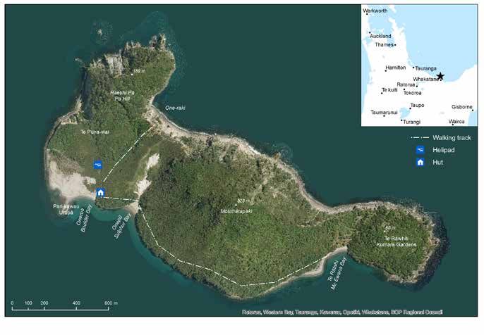
Moutohorā is a steep remnant volcano, located in the Bay of Plenty (Fig. 1). This 143-ha island
is situated 9.55 km northwest of Whakatāne and 7.20 km from the mainland at its closest point.
The nearest island to Moutohorā is Moutoki Island, which is part of Ngā Moutere o Rūrima (the
Rūrima Islands) and is located 7.15 km to the west (DOC 2008b).
Figure 1. Map of Moutohorā (Whale Island) Wildlife Management Reserve.
Moutohorā, Whakaari/White Island, Te Paepae o Aotea (Volkner Rocks) and Ngā Moutere o
Rūrima all fall within the White Island Ecological District—and this district, along with the
neighbouring Ecological Districts of Rotorua, Ōtanewainuku, Tauranga and Motiti, form the
Northern Volcanic Plateau Ecological region, grouped as such due to their closely related
characteristics (McEwen 1987).
2.2 Climate
The MetService has an automatic weather station at Whakatāne Airport, which recorded a mean
annual temperature of 14.8°C and 2792 hours of sunshine (the highest national sunshine hours) in
2013 (NIWA 2014). The climate on Moutohorā is likely to be 1–2°C warmer than this (DOC 1999).
Moutohorā (Whale Island) Wildlife Management Reserve ecological restoration plan 3The MetService also recorded 909 mm of rain at Whakatāne Airport in 2013 (NIWA 2014). A
rainfall gauge was installed on Moutohorā in 2012 at the lower helicopter pad, which is checked
by field staff during each visit. To date, this indicates that Moutohorā has an average of 14% less
rainfall than the neighbouring mainland.
The prevailing winds are northwesterly, with northeasterly storms occasionally sweeping the
island. Frosts are seldom recorded on Moutohorā (DOC 1999).
2.3 Geology and landscape
Moutohorā is located in the northern zone of the Taupō-White Island Marine Depression, an
area of frequent volcanic activity (Ramsay & Hayward 1971). The island is a remnant volcanic
cone that has been severely eroded over time, particularly on the northern sides, with contiguous
bluffs found on the west through to the lower-lying eastern plateau. The island has two peaks: the
higher central Motuharapaki (323 m) and western Raetihi Pā (Pā Hill, 189 m) (Fig. 1).
Large areas of sedimentary rock are present at Oneroa (formerly Boulder Bay or Camp Bay) and
north of the eastern terraces behind Te Rātahi (formerly McEwan’s Bay). Filled valleys containing
windblown sand also occur behind Te Rātahi and at Oneroa, where this has resulted in the
creation of a wetland area. No natural streams occur. Large boulder banks can be found at sea
level at the western ends of both Oneroa and Te Rātahi bays, impounding wind-created dunes.
The boulder banks comprise variable-sized rounded blocks and boulders of andesite material
that originated from debris fans off the escarpments.
There are only three sandy bays on Moutohorā (Oneroa, Onepū (formerly Sulphur Bay) and
Te Rātahi), all of which are located on the southern coast.
Geothermal activity occurs at five main sites, particularly in and above Onepū in an area known
as Waiariki (Sulphur Valley). Numerous hot springs and vents are present in the toe of the slump
field, with hot water springs visible at mean low tide (Moore 1990). Occasional vents are also
visible on the southern slopes of the central cone below Motuharapaki, and in the sand and water
at Te Rātahi during mean low tide.
2.4 Soils
The soils of Moutohorā are volcanic in origin, ranging from a thin layer of ash, through to pumice
or tephra over weathered andesite that takes the form of fractured, variably-sloped outcrops
or debris fans (Rijkse 1980). The soils vary greatly in depth, particularly along the lower slopes
around Oneroa and Te Rātahi, with patchy layers of underlying sandy soils found elsewhere on
the island.
Soil fertility is generally low, apart from the colluvial soils at Oneroa, which have relatively high
phosphorus levels. The soils do contain some organic matter from humus accumulation, however,
which is represented by variable duff layers over sand or ash, and further nutrient enrichment
occurs through guano deposits from nesting seabirds. The soils also have good physical
properties for plant growth, with the exception of those found on the northern seaward cliffs.
Neither water nor wind cause severe erosion on the island due to a good level of ground cover.
2.5 Mammalian pest eradication
Rabbits (Oryctolagus cuniculus), goats (Capra hircus), sheep (Ovis aries), cats (Felis catus) and
Norway rats (Rattus norvegicus) were all once present on Moutohorā and had severe impacts on
the island. In its most degraded state, the island was described as being bare soil and rock due
to habitat degradation, which was mainly the result of extensive browsing by goats and rabbits
(Smale & Owen 1990).
4 Moutohorā (Whale Island) Wildlife Management Reserve ecological restoration planRabbits were first observed on the island in 1968, having been illegally released by fishermen to use as bait for the crayfishing industry. At their peak in 1973, rabbits numbered 375 individuals per hectare (Pedersen & Roche 1973). Several poison operations (aerial drops of 1080 carrot baits, 1080 paste and hand-broadcast brodifacoum) took place from 1973 until 1987, when this species was finally eradicated from the island. Goats were released onto the island during the mid- to late-1800s as a source of food for shipwrecked sailors (Smale & Owen 1990) and were later killed for use as crayfish bait by local fishermen. Over 1000 goats were shot by hunters from the New Zealand Wildlife Service in 1964 and eradication was achieved in 1977 (Ogle 1990a). Sheep also once grazed the island, having been taken there for a small-scale farming operation in 1915. However, these were removed in 1943. Cats were once present in sufficiently large number for camping parties to shoot them during their stay, resulting in their eradication from the island. Norway rats were noted as being present on the island between 1910 and 1920, possibly having arrived on barges bringing stock to the island. By 1956, they were reportedly present in large numbers (Imber 1971). This led to a rāhui on the harvest of kuia (grey-faced petrel, Pterodroma macroptera gouldi) chicks, as the population showed signs of decline in the early 1960s, almost certainly due to rat predation of chicks and eggs. There is no record of ship rats (Rattus rattus) or kiore (Rattus exulans) having been present on Moutohorā, although the latter did inhabit the neighbouring Ngā Moutere o Rūrima. From 1969, Norway rats were trapped and poisoned with warfarin on a small scale, as part of an investigation into the effect of rats on breeding petrels. Over the following years, various other poison baits were hand laid on the island, including EPIBLOC® (a chemisterilant) in 1977; Racumen in 1978; brodifacoum (as part of a Ministry of Agriculture and Fisheries field trial), 1080 and Talon® (the latter a trial for ICI New Zealand) in 1980; and brodifacoum in 1982. From 1985 to 1987, 1080-infused carrots, Talon® 20P or bromodialone baits were either hand laid or spread aerially, leading to the eventual eradication of rats from the island in 1986. This poison operation continued until 1987, when the island was declared pest free. As at June 2014, no incursion of introduced mammalian pests has occurred on Moutohorā—and the eradication of these pest species has had many beneficial effects on the island ecosystem. For example, Imber et al. (2003) determined that 13 years following the eradication of mammalian pests, the kuia population had doubled in size. In addition, vegetation monitoring using photopoints has also documented significant changes in the density and diversity of vascular plants (Shaw et al. 2003), with the island being transformed from one that was dominated by grass swards to one that is now predominantly covered with regenerating pōhutukawa-māhoe- kānuka (Metrosideros excelsa–Melicytus ramiflorus–Kunzea spp.) forest. Moutohorā (Whale Island) Wildlife Management Reserve ecological restoration plan 5
3. Flora
    3.1   Forest structure and revegetation
		Background
          Moutohorā has been recognised as having a high restoration value due to its varied assemblage
          of ecosystems and habitats. When the island was purchased by the Crown in 1984, the vegetation
          was in a highly modified state, with most of the island covered in rank grass, and forest and
          shrub hardwood remnants in the gullies and on steeper sites (Regnier 1985). At this time, the
          native plant communities that were present on the island included areas of rarauhe (bracken,
          Pteridium esculentum), kānuka scrubland, scattered pōhutukawa, and coastal forest containing
          māhoe, ngaio (Myoporum laetum), kōtukutuku (tree fuchsia, Fuchsia excorticata), whau (Entelea
          arborescens), tutu (Coriaria arborea) and mānuka (Leptospermum scoparium). A number of
          other species were also present in low numbers, including patē (seven-finger, Schefflera digitata),
          tī kōuka (cabbage tree, Cordyline australis), harakeke (flax, Phormium tenax), houpara (coastal
          five-finger, Pseudopanax lessonii), kohekohe (Dysoxylum spectabile), karaka (Corynocarpus
          laevigatus), kawakawa (Piper excelsum subsp. excelsum), mangeao (Litsea calicaris) and karo
          (Pittosporum crassifolium) (McGlynn 1990).
          Based on the composition of remnant stands on the island and the vegetation of adjacent
          mainland areas, it is likely that pōhutukawa forest was once the dominant vegetation, with a
          component of mangeao (Parris 1971) and Podocarpaceae (Rijkse 1980). Coastal vegetation on
          the adjacent mainland also provides some indication of the species that were once present—for
          example, Kohi Point Reserve has a pōhutukawa-mangeao canopy with pūriri (Vitex lucens),
          mamaku (Cyathea medullaris), kohekohe, and an understorey of hangehange (Geniostoma
          ligustrifolium var. ligustrifolium), kawakawa and nīkau (Rhopalostylis sapida) (Beadel & Shaw
          1988). It has been suggested that pollen analysis would be a viable approach to better determine
          historical vegetation patterns on Moutohorā (Wilmshurst 1998), as this can help to ascertain past
          species, at least to family level.
          A planting programme was started in 1984 by the New Zealand Wildlife Service and completed in
          1989 by DOC, with assistance from the Whakatāne Branch of Forest & Bird and other volunteers
          (McGlynn 1990). This programme aimed to:
              •• Accelerate rates of natural succession by re-introducing previously lost species
              •• Enlarge the population size of existing species
              •• Create buffer zones of fire-resistant vegetation (e.g. harakeke) to minimise the risk of fire
              •• Expand the food resources and habitats for indigenous animals
          The planting programme aimed to select key areas for replanting and to establish viable seed
          sources for the rest of the island. Seed and cutting material was collected within a 25-km radius
          of the island, with a preference for sourcing plants from the island itself and, where possible,
          growing plants from seed (McGlynn 1990). Species such as harakeke, Coprosma spp. and ngaio
          were also used to create protective ‘fire tolerant’ plantings in certain vulnerable areas, which
          included landing sites traditionally used by the public and open sites with grassland (McGlynn
          1990). These fire tolerant plantings no longer dominate these areas, however.
          The planting programme resulted in over 11 000 plants representing 45 species being established
          on Moutohorā (Appendix 1). Most of these were broadleaved shrubs or small trees, but the
          plantings also included large broadleaved trees, climbers, harakeke and dune plants. At Oneroa,
          a considerable area of low kānuka was interplanted with canopy species including karaka,
          kohekohe and pūriri, and sub-canopy karo and houpara (McGlynn 1990).

6         Moutohorā (Whale Island) Wildlife Management Reserve ecological restoration plan
Since the elimination of browsing animals and rodents from the island (see section 2.5), and
the implementation of this planting programme (McGlynn 1990), the vegetation on Moutohorā
has changed dramatically, with a flora of greater diversity, vigorous growth, regeneration
and the recruitment of seedlings. The vegetation on the island is most accurately mapped by
Chakraborty (unpubl. data 2007) and adapted by B. Christensen (see Appendix 2).
Moutohorā is presently covered by a mosaic of pōhutukawa forest, māhoe forest, kānuka
scrubland, rarauhe and pasture grasses, comprising 190 indigenous and 110 exotic plant species
(Ogle 1990a; Appendix 1). There is natural regeneration of canopy species such as pōhutukawa,
māhoe and kānuka, and understorey vegetation shrubs such as karamu (Coprosma spp.),
koromiko (Hebe elliptica), hangehange and taupata (Coprosma repens) are also present. Fern
species in the understorey include rasp fern (Blechnum parrisiae), mākaka (common maiden hair,
Adiantum cunninghamii) and huruhuru whenua (shining spleenwort, Asplenium oblongifolium).
New grasslands are also now covering areas that were previously bare, and existing grasslands
are being replaced by kānuka, rarauhe and club sedges. For example, the most ecologically
important stands of a recently recognised new species of kānuka (de Lange 2014) are located
on the sand dunes at Oneroa, where they occupy an area of c. 3 ha (Smale & Owen 1990);
kōwhangatara (spinifex, Spinifex sericeus) is predominantly found on the ridges of the sand
dunes in Oneroa Bay, along with small remnant areas of pīngao (Ficinia spiralis); and areas of
ongaonga (stinging nettle, Urtica ferox) occur near Motuharapaki and extending down the sides.
The small wetland area that is impounded behind the sand dunes at Oneroa comprises a
variety of species, with the most abundant being Cyperus spp. Sea rush (Juncus kraussii var.
australiensis) also occurs in clumps, indicating the saline nature of this wetland. Scattered wīwī
rushes (knobby clubrush, Ficinia nodosa; sea rush) and kānuka contribute to a dense cover
interspersed with open areas of water and mud.
Progress to date
Unfortunately, no formal monitoring of the planting programme was undertaken. However,
general observations suggest that the programme has been very successful given the dense
shrub and tree layer that is now evident across the entire island, as confirmed by the network of
permanent photopoints that was established in 1990 to monitor regeneration of native vegetation
on the island. The most obvious changes to the vegetation on the island have been the reduction
in areas of grassland and the increase in kānuka and pōhutukawa (Shaw et al. 2003). In 1991, two
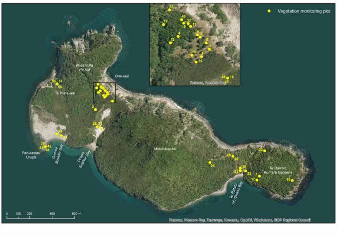
20 × 20 m plots were set up, one located in Oneroa and the other in Te Rātahi (Appendix 3), and
in 2003, the Oneroa plot was remeasured and standardised to fit the standard permanent plot
method (Hurst & Allen 2007). Additionally, 14 grassland plots were established in 1991, however
these have not been re-measured since their establishment.
Three pōhutukawa plots were also established on Moutohorā as part of a wider study of
pōhutukawa forest structure, composition and dynamics in the Bay of Plenty. This study noted
that Moutohorā was only one of two sites sampled in which successful pōhutukawa regeneration
was occurring (Bylsma 2012).
Discussion
Following completion of the revegetation planting programme in 1989, no further planting was
carried out, as all four objectives had been achieved. Further revegetation will not be necessary
in the future, as a range of plant species have successfully been established on the island, the
majority of which is now covered by native vegetation.
Recent revision of the taxonomy of kānuka has revealed the existence of an endemic species to
Moutohorā (K. salterae), which differs from K. robusta as it favours frequent disturbance and can
be found in geothermally active areas of the island (de Lange 2014). The origin of this species is
Moutohorā (Whale Island) Wildlife Management Reserve ecological restoration plan 7currently unknown. This species has been classified as At Risk—Naturally Uncommon under the
New Zealand Threat Classification System (de Lange et al. 2013), indicating that it may require
further consideration for future management.
Proposed future activities
•• Determine whether any management actions are needed for K. salterae.
3.2 Threatened plant reintroductions
Background
The value of Moutohorā as a haven for threatened species was first raised at the conclusion
of the planting programme in 1989 (McGlynn 1990). In 1997, a strategy for threatened
plant reintroduction to Moutohorā was prepared (Shaw 1997), which was followed by a
transfer proposal (Gosling 1999). In August 1999, a 3-year programme for threatened plant
reintroductions commenced that involved 13 species. However, at the beginning of this
programme, not all species of threatened plants were available and further trialling of sites was
required, resulting in the continuation of this programme for a further 6 years, which allowed
more data to be gathered by monitoring the plantings across a range of sites (P. Cashmore, DOC,
pers. comm.). The two key objectives for the programme, as described by Gosling (1999), were to:
1. Establish self-sustaining populations of some Bay of Plenty threatened plant species:
•• Mawhai (native cucumber, Sicyos mawhai)
•• Pīngao (Ficinia spiralis)
•• Scrub daphne (Pimelea tomentosa)
•• Parapara (Pisonia brunoniana)
•• Waiu-atua (shore spurge, Euphorbia glauca)
•• Autetaranga (sand daphne, Pimelea villosa ssp. villosa)
•• Hinarepe (sand tussock, Poa billardierei)
•• Matangoa (New Zealand cress, Rorippa divaricata)
•• Tawāpou (Planchonella costata)
•• Nau (Cook’s scurvy grass, Lepidium oleraceum)
•• Coastal māhoe (Melicytus novae-zelandiae)
•• Holloway’s crystalwort (Atriplex hollowayi)
•• New Zealand spinach (Tetragonia tetragonoides)
2. Restore those elements to the Moutohorā ecosystem that will give it a more diverse
ecological character that is closer to that which likely occurred prior to vegetation
clearance by humans and the liberation or escape of various introduced animals.
Progress to date
The threatened plant reintroduction programme was carried out annually until 2010. Individual
plants or groupings were demarcated with numbered stakes, allowing the presence/absence and
height of previous plantings to be recorded during annual planting sessions. At its conclusion in
2010, all numbered stakes were removed.
Discussion
The threatened plant species reintroductions had varying success. Only 11 of the 13 proposed
species were actually reintroduced to the island—the reintroduction of Holloway’s crystalwort
did not occur due to an inability to source plants from Northland, and coastal māhoe, which was
already established on the island, was not further supplemented due to a lack of nursery stock.
Of the 11 remaining species, only six (mawhai, pīngao, scrub daphne, parapara, tawāpou and
waiu-atua) successfully established self-sustaining populations. One species that struggled
8 Moutohorā (Whale Island) Wildlife Management Reserve ecological restoration planto establish a self-sustaining population was nau. This perennial herb requires high rates of
recruitment to enable the plant to persist, and monitoring showed that individuals survived
for 3 years and then perished—and although plants set seed, no recruitment was evident. The
reintroduction of matangoa was also not successful.
In the early stages of the planting programme, a few threatened plant species were planted on
archaeological sites. However, this was discontinued.
Proposed future activities
•• Reintroduce Holloway’s crystalwort, William’s broom (Carmichaelia williamsii) and thick-
leaved tree daisy (Olearia pachyphylla), as outlined in the former CMP (DOC 1999).
•• Publish the results of the 12 years of threatened plant reintroduction work.
•• Determine why nau failed to establish on the island, despite the presence of suitable
growing conditions.
Moutohorā (Whale Island) Wildlife Management Reserve ecological restoration plan 94. Invertebrates
Background
Invertebrate surveys on Moutohorā were undertaken as early as 1970, prior to the island
becoming free of mammalian pests. The most comprehensive survey of invertebrates was
undertaken by Patrick (1996), whose species list has since been supplemented by additional
surveys for spiders, land snails and most recently ants.
Collections of invertebrates taken from Moutohorā now reside at:
•• Auckland War Memorial Museum, Auckland (Quilter 1971)
•• Otago Museum, Dunedin (Patrick 1996; Fitzgerald 2006)
•• University of Otago, Dunedin (Patrick 1996)
•• University of Canterbury, Christchurch (Patrick 1996)
•• Museum of New Zealand Te Papa Tongarewa (Ogle 1990b; Fitzgerald 2006)
•• New Zealand Arthropod Collection, Landcare Research, Auckland (Kirk 2013)
•• Private collections—B. Barratt & B. Patrick (Patrick 1996)
Progress to date
The first documented records of insects on Moutohorā were made by Quilter (1971), following
the Auckland University Field Club trip in 1970. During this trip, a comprehensive collection of
insects was collected, from which 26 species from seven orders were identified.
In 1995, Patrick (1996) conducted a week-long survey of the island, during which 285 invertebrate
species were identified. The main objectives of this survey included identifying invertebrate
fauna prior to the proposed introduction of tuatara (Sphenodon punctatus) to Moutohorā;
identifying species of regional or national significance; and identifying key invertebrate habitats.
Various survey methods were used, including pitfall, malaise and light traps, hand-searching,
sweeping, netting, beating larvae from their host, and searching under rocks and wood during
the day. Of the 285 species found on Moutohorā, 264 were insect species. Four species noted by
Quilter (1971) were not recorded during this survey.
Patrick’s (1996) results also included 14 species of spiders; however, a more extensive collection
had previously been made by David Court during the Auckland University Field Club trip in
1970 and the Offshore Island Research Group (ORIG) trip in 1985/86. Although not all of his
findings were reported, Court recorded over 60 species of spiders in leaf litter samples from
Moutohorā (Fitzgerald 2006), the majority of which are also found on other northern offshore
islands. Significantly, a lone male katipō (Latrodectus katipo), an endangered endemic spider, was
found during this trip following extensive searching—the only known record of this species on
Moutohorā (Wright 1986; Fitzgerald 2006).
More recently, two additional spider surveys have been conducted by Fitzgerald (one in 1999
prior to the translocation of tīeke (North Island saddleback, Philesturnus rufusater) and a
follow-up survey in 2005 post-translocation of tīeke) to ascertain whether any change in the
spider fauna on Moutohorā could be attributed to the presence of tīeke on the island. A total
of 53 species were recorded during these surveys (Fitzgerald 2006), of which nine had not
been previously documented, bringing the total known species of spiders on Moutohorā to 96.
However, it was difficult to conclude whether spider abundance had been affected by the well-
established tīeke population on Moutohorā due to the considerable changes in vegetation over
this time period which may also have affected spider populations.
Land snails have also been collected on Moutohorā: two specimens initially in 1984 by Ogle
(1990b), followed by a survey during the ORIG trip in 1985/86. Collections taken from leaf litter
10 Moutohorā (Whale Island) Wildlife Management Reserve ecological restoration plansamples and off tree bark yielded a total of 15 species, of which 14 were indigenous. All but one of
these species are typical of those existing in dry or well-drained habitats elsewhere (Ogle 1990b).
Wasps have not posed a significant problem on Moutohorā, although an invasive yellow flower
wasp (Radumeris tasmaniensis) was discovered on the beach at Te Rātahi in 2011.
In 2013, during a routine biosecurity survey for invasive Argentine ants (Linepithema humile),
six ant species were identified, including one endemic species (southern ant, Monomorium
antarcticum) (Kirk 2013).
Discussion
The invertebrates of Moutohorā are considered to be diverse. They comprise insect species
that are commonly found throughout New Zealand, the majority of which are representative
of northern New Zealand. This supports geological evidence that Moutohorā has become
isolated from the mainland relatively recently. The discovery of a primitive and fairly immobile
moth fauna also indicates a recent mainland connection (Patrick 1996), as does the fact that
although three-quarters of the spider species identified on Moutohorā are considered endemic to
New Zealand, there is an absence of island endemic species (Fitzgerald 2006).
The general abundance of insect life on Moutohorā is credited to the rapid regeneration of
vegetation following the eradication of mammalian pests in 1986/87. As such, Patrick (1996)
concluded that there would be no sizeable impact or conservation implications for the insect
fauna on Moutohorā if tuatara were returned to the island.
It is possible that ongoing vegetation regeneration may result in further changes to the
invertebrate fauna on Moutohorā, as shown by Fitzgerald’s (2006) study on the effects of tīeke
on spiders. Whilst spiders that inhabit forests may broaden their range across the island, those
that inhabit grassland and open scrub are likely to become more localised or transient, cycling
irregularly through colonisation and extinction events (Wright 1986; Fitzgerald 2006).
Although the 2013 biosecurity survey found that Moutohorā was clear of Argentine ants, pest
invertebrates would pose a very real threat if they did colonise the island, and so vigilant
biosecurity measures should continue to remain a priority.
Proposed future activities
•• Review the lists of invertebrate species recorded on Moutohorā during past surveys and
compile into one updated list, ensuring that current taxonomic classifications are used.
•• Encourage further surveys by researchers and students to create a current record of
invertebrate species present on Moutohorā, as well as more extensive studies into currently
known species. This will help with the detection of any changes to species presence and
composition that may result from continued forest regeneration.
•• Ensure that DOC staff, visitors and concessionaires are made aware of the risks posed by
invertebrate pests to the island and adhere to the strict biosecurity measures in place to
avoid introduction of these pests when on Moutohorā (see section 11.2—Biosecurity).
Moutohorā (Whale Island) Wildlife Management Reserve ecological restoration plan 115. Reptiles
5.1 Tuatara
Background
Tuatara (Sphenodon punctatus) were reported to have occurred on Moutohorā until the early
1900s, when they succumbed to extinction as a result of habitat degradation and predation
by Norway rats (K. Merito, Te Tapatoru ā Toi, pers. comm.). A plan to reintroduce tuatara to
Moutohorā was developed in the mid-1990s, not only to return them to their former home range
and restore a significant missing component of the Moutohorā ecosystem, but also to act as a
safeguard for the neighbouring Ngā Moutere o Rūrima population, which is vulnerable to rodent
incursion, poaching and fire (Owen & Newman 1996). This reintroduction was in alignment with
Objective 12 of the Tuatara Recovery Plan, which included the establishment of translocation
survivorship techniques (Cree & Butler 1993), and the translocation had the full support of Ngāti
Awa.
In October 1996, 32 tuatara (12 males, 20 females) were transferred from Moutoki Island (a 0.9-ha
island c. 8 km northwest of Moutohorā, within Ngā Moutere o Rūrima) and released at four sites:
Oneroa, Hut Valley, Onepū and Te Rātahi (5 females, 3 males per site). Two of these sites were
situated in mid-successional kānuka-māhoe forest, while two were in early successional kānuka
forest—and within each habitat type, one site had a low density of kuia burrows while the other
had a high density. Twenty tuatara were placed into artificial burrows constructed from a plastic
bucket and novacoil, while the remaining 12 were released into petrel burrows or placed on open
ground. A pre-translocation survey of invertebrates by Patrick (1996) confirmed that there was
sufficient food supply for tuatara and that the reintroduction was not likely to have an adverse
impact on the invertebrate population.
Concern that the small number of tuatara transferred could lead to genetic inbreeding led to
a decision to release more females than males. The risk of inbreeding was further reduced by
translocating gravid females, whose mate had hopefully not been transferred to the island at the
same time (K.L. Owen 1998). It was considered that the translocation would be deemed a success
if 5 years following the translocation, 50% of tuatara had survived and at least five island-born
juveniles were found, indicating that recruitment was occurring. This objective was later revised
to 2–3 island-bred individuals by the newly formed Tuatara Recovery Group (TRG)3.
Progress to date
Post-translocation monitoring was undertaken by Graham Ussher, University of Auckland, as
part of a PhD study to assess population responses to recent habitat disturbance and the success
of establishing a new tuatara population under varied environmental conditions. This involved
six 2-week-long surveys of 20 tuatara that had transmitters attached by a harness, which were
carried out every 3 months between October 1996 and December 1997. Monitoring techniques
included day and night searches, during which observers walked 5–10 m apart along a transect
or grid network looking for sign of scats, tuatara burrows (commonly oval shaped and smaller
than petrel burrows), burrow disturbance and sloughed skin. All captured tuatara were weighed,
measured (snout-vent length, new and old tail) and temporarily marked with a xylene-free
pen. The most suitable period for monitoring was considered to be between mid-summer and
early autumn (December to March/early April), as kuia were not present at this time. This also
coincides with the tuatara breeding period, during which males display and approach females
in order to mate. The absence of petrel background activity and noise during this time meant
3 These TRG guidelines were formulated in the early days of tuatara translocation, at which time the measurement of a
successful translocation was yet to be determined conclusively (Ussher 2002a).
12 Moutohorā (Whale Island) Wildlife Management Reserve ecological restoration planthat tuatara could be heard more readily as they moved through the understorey, and any soil
disturbance at burrow entrances could be attributed to reptile movement rather than petrel
activity. Monitoring effort has been focussed on three of the four original release sites, as this
was considered to be of greater benefit than undertaking a superficial survey across the entire
island—however, this does mean that the Onepū population has not been monitored.
Nine months post-translocation, 88% of the tuatara population survived and only two of the
20 tuatara were still utilising artificial burrows. The majority of tuatara had remained close to
their original release site and had gained weight, indicating that there was suitable food and
habitat availability.
Further monitoring was carried out in November 2000 and November 2001 by University of
Auckland students, during which 28 of the original founder population of 32 was observed. No
juvenile tuatara were found during extensive day and night searches in the Te Rātahi and Hut
Valley sites.
In February 2002, Ussher re-monitored the population, and observed eight of the original
founders and three island-born juveniles. The collation of all recaptured tuatara weights
indicated that the tuatara were in good body condition, with some weight loss over the
summer period that was regained in the autumn. Dispersal was highly variable and included
an observation of one tuatara at Motuharapaki. However, a core population of 3–6 founders
remained at each of the four release sites. Although the initial TRG target (50% of founder
population recaptured after 5 years with evidence of 2–3 wild-born juveniles) was not achieved
on this occasion, combined observations from several monitoring trips would be more likely to
provide evidence for this, rather than a one-off monitoring trip—and Ussher (2002a) believed that
the Moutohorā population was likely to become self-sustaining in the long term.
Due to the scattered nature of the original four release sites, there was concern that the long-term
self-sustainability of the tuatara might be compromised by reproductive isolation and the slow
breeding rate of this species. Consequently, Ussher (2002a) suggested securing the population
of at least one of the release sites through a second translocation of young tuatara from Moutoki.
Te Rātahi was the best candidate for this translocation, as it had provided the most evidence
of a breeding population (two wild young tuatara had been found there) and contained a large
area of suitable habitat for tuatara dispersal. The Hut Valley and Oneroa areas would remain
important sites for continued research into the reestablishment of tuatara and could also be used
in the future as comparison sites with Te Rātahi, with a focus on population growth, dispersal and
behaviour (Ussher 2002a).
In October 2008, 30 tuatara (16 females, 14 males) were translocated from Moutoki to Te Rātahi.
Only juvenile tuatara ranging in body length from 140 mm to 170 mm were selected for this
second translocation to Moutohorā, partly because a larger number of juveniles had been
noted on Moutoki following the first translocation and partly to ensure that the adult breeding
population remained intact (Ussher 2002a). All animals were inserted with a Passive Integrated
Transponder (PIT) tag and placed into artificial burrows within a 10 × 10 m grid. One month
following the translocation, three people searched for 3 hours and located five of the newly
released tuatara, each of which had lost 5–10% of its body weight (S. King, DOC, unpubl. data
2009). Given the minimal search effort of this monitoring trip, it was not conclusively proven that
the second translocation had been successful (where 30% of released individuals can be found).
Monitoring of the population 5 years following the translocation has not yet occurred.
Discussion
The TRG determined that Moutohorā could support a population of c. 8500 animals (100
tuatara per hectare) (Gaze 2001). More recent guidance on holding capacity suggests that the
island could actually only support this density of tuatara over half its area (taking into account
unsuitable habitat such as cliffs or dense seabird populations; N. Nelson, Victoria University of
Wellington, pers. comm.). However, the current population estimate falls well within this.
Moutohorā (Whale Island) Wildlife Management Reserve ecological restoration plan 13To determine whether the 2008 translocation has successfully supplemented the earlier release,
it is recommended that post-translocation monitoring occurs as soon as resources allow. Ussher
(2002a) also recommended long-term monitoring of the founder population to determine
resource limitation and inter-specific competition. The opportunity to undertake this research
could be offered to a suitable tertiary institute such as Victoria University of Wellington,
which specialises in reptile ecology and conservation. Sufficient temporal monitoring periods
(potentially on a decadal basis) will be required to witness a self-sustaining population, to
account for the long lifespan and slow reproductive rate of tuatara.
The harvest of kuia was resumed in 2012 under permit to Ngāti Awa. Disturbance to known
tuatara territories should be limited, with harvesters being made aware of sensitive areas. In
addition, harvesting tools should not include fish hooks or barbed wire to limit damage to
tuatara, as tuatara have been found with missing eyes and limbs on Motunau, where harvesting
has occurred (J. Heaphy, DOC, pers. comm.). With training, the monitoring of tuatara could be
undertaken jointly with the kuia harvest.
Proposed future activities
•• Ensure that future monitoring encompasses the entire island, where access allows, as the
tuatara are likely to be widely dispersed since their initial release.
•• Carry out post-translocation monitoring of the 2008 population to determine the success of
that second translocation. Particular emphasis should be placed on checking that the island
founders are in good condition and finding any island-hatched young. If no young are
evident, research should be undertaken to determine which factors are limiting the success
of the new population.
•• PIT tag all recaptured founder and island-hatched tuatara to deter wildlife smugglers and
to trace the individuals back to the island in the event that they are illegally removed. This
would also allow the founder population to be identified and contribute to the knowledge
base of translocated populations.
•• Reduce habitat disturbance around known tuatara territories.
•• Undertake monitoring of the Moutoki population to ensure that the two translocations
have not significantly impacted on the remaining population. This is essential if any
further translocations to Moutohorā or elsewhere are planned in the future.
•• Adopt new monitoring techniques for determining population trends, as directed by the
Reptile Technical Specialist Group.
•• If further translocations from Moutoki do occur, reduce their impact on this population by
only transferring juveniles, only selecting every 2nd or 3rd animal found, only removing
individuals from discrete areas and leaving at least 10–15 years between each transfer.
•• Before considering any future translocations, conduct research into limiting factors for
the tuatara population on Moutohorā, such as the possibility of a genetic bottleneck or a
change in environmental conditions. Also, adhere to a long-term recovery goal that is in
alignment with the Tuatara Recovery Plan (Gaze 2001) to ensure that genetic diversity is
maintained by increasing population levels.
5.2 Lizards
Background
Three lizard species are found on Moutohorā: common gecko (Woodworthia maculata),
copper skink (Oligosoma aeneum) and a ‘taxonomically indeterminate’ species Oligosoma aff.
infrapunctatum “crenulate” or the crenulate skink (Hitchmough et al. 2013). This latter species
was formerly classified as the speckled skink (Oligosoma infrapunctatum) (Towns 1987). However,
preliminary genetic work that is currently being undertaken indicates that O. aff. infrapunctatum
14 Moutohorā (Whale Island) Wildlife Management Reserve ecological restoration plan“crenulate” is likely to be a distinct species (R. Hitchmough, DOC, pers. comm.). Therefore, any
former reference made to the speckled skink will hereby be changed to its current impending
title of crenulate skink.
Whilst both the common gecko and copper skink are classified as Not Threatened, the crenulate
skink species has been classified as At Risk—Relict (Hitchmough et al. 2013). Moutohorā is
believed to be the stronghold of the crenulate skink, which is also found on Mokoia Island
in Lake Rotorua/Te Rotorua nui ā Kahumatamomoe, at a scattering of central North Island
mainland sites and at a couple of Westland mainland sites (R. Hitchmough, DOC, pers. comm.).
Collections of lizards taken from Moutohorā now reside at:
•• Auckland War Memorial Museum, Auckland (Towns & Hayward 1973)
•• Victoria University of Wellington, Wellington (Owen 1992)
Progress to date
Lizard surveys have been carried out on Moutohorā since 1970, during visits by the Auckland
University Field Club. In 1971, a density estimate of 645 lizards per hectare was calculated for
Moutohorā using a 50 × 50 ft quadrat (Towns 1971). By 1992, a dramatic increase in lizard numbers
had been noted following an intensive search for them, which was largely attributed to the
removal of rats from the island (Owen 1992).
The earliest survey recorded a skink species (Leiolopisma sp.) as being the most abundant on
Moutohorā, with the common gecko not believed to be very ‘common’ (Towns 1971). However,
anecdotal evidence suggests that the distribution and density of common geckos has changed
dramatically since then, with the population considered to be widespread and in great abundance
on Moutohorā today. This was reflected in results from an Auckland University Field Club
trip over 2000/01, during which only five skinks were caught in grassland habitat and none
were caught in kānuka regenerating forest over a total of 125 trap nights, whereas a minimum
density of 600 common geckos per hectare was measured in forested areas (Ussher 2002b). This
difference can be attributed to a change in vegetation cover, which was considerably affected by
goats and rabbits in the 1970s. Since then there has been considerable regeneration, providing
greater cover and leading to less suitable habitat for skinks (Ussher 2002b). During the same trip,
gecko utilisation of pōhutukawa flowers was also measured, yielding a density of 115 geckos/m3
over 2.5 m3 and 25 geckos/m3 over 1.3 m3. These gecko densities are markedly greater than those
recorded or observed elsewhere (Ussher 2002b).
The habitat use of crenulate skinks was studied during the Offshore Island Research Group trip
in 1985/86. Snout-vent length measurements of individuals collected in pitfall traps suggested
that maturity is reached at 65–70 mm when they are approximately 2 years of age (Wright 1986).
In 1992, authority was granted to Dr C. Daugherty of Victoria University of Wellington to collect
two crenulate skink specimens from Moutohorā for taxonomic review purposes of New Zealand
lizards (Owen 1992). Current taxonomic work of this species is using genetic material gathered
from these specimens. In 2002, a further three crenulate skinks were obtained from Moutohorā
for the purpose of comparing evaporative water loss in endemic skinks. These three lizards were
released back to the island once the study was completed (Nielson 2002).
Searches specifically targeting shore skinks (Oligosoma smithi) have also been conducted on
Moutohorā, the presence of which is as yet unconfirmed on the island—although past records
indicate that they may have once been present (Towns 1987; Owen 1992). No shore skinks were
found following intensive searching for 620 minutes at six locations across the island (Owen
1992) or by setting eight pitfall traps for 24 hours along the driftwood line at Oneroa (Garrick
1992). More recently, a total of 10 person hours were spent searching the northern boulder
beaches of Moutohorā; however, this was again unsuccessful. The absence of shore skinks despite
the availability of suitable habitat is considered puzzling (Ussher 2002b), particularly as nearby
Moutoki Island holds a generous population of this species and shore skinks have recently been
confirmed present on Rurima Island (Baling 2014).
Moutohorā (Whale Island) Wildlife Management Reserve ecological restoration plan 15Discussion
In 1987, a management plan for reptiles on Moutohorā was written by Towns (1987). Within
this, it was stated that Moutohorā was considered to be a ‘significant location for rare species
of northern reptiles’ due to the absence of rats (Towns 1987: 3). Since the publication of this
document, tuatara have been successfully translocated to Moutohorā.
In 1992, it was recommended that a monitoring plan be established for lizards on Moutohorā
(Owen 1992). Continued changes to the vegetation are expected to result in changes in
population numbers, with the potential for new species that were previously present in low
numbers to be discovered. Furthermore, whilst common geckos are abundant throughout most
of the island, little is known about the current range and distribution of the two skink species on
Moutohorā.
As indicated by Towns (1987), the pest-free status of Moutohorā makes it a potentially significant
location and sanctuary for some of New Zealand’s lizards. The reintroduction of new lizard
species to Moutohorā would allow the lizard population to continue to contribute to ecosystem
restoration through an increase in seed dispersal and pollination of native flora. Furthermore, the
restoration of appropriate lizard species to the island will increase the security of rare species and
enable certain lizard populations to be returned to their former ecological range (L. Adams, DOC,
pers. comm.).
It has previously been considered that McGregor’s skink (Oligosoma macgregori), Whitaker’s
skink (Oligosoma whitakeri) and Duvaucel’s gecko (Hoplodactylus duvaucellii) would all be
suitable for transfer, as the island falls within their ecological range (Towns 1987; K. Owen, DOC,
pers. comm.). Moutohorā is also the southernmost range for the moko skink (Oligosoma moco)
(McEwen 1987); however, the introduction of this species may be difficult due to competition
pressures exhibited by the crenulate skink (R. Hitchmough, pers. comm.).
Based on recent advice from the Lizard Technical Advisory Group, a list of candidate species for
transfer has been established (Table 1). The skink species selected are indicative of those that
would suitably co-exist with the crenulate skink, which is viewed as a priority species on the
island. Other species may also become likely candidates in the future.
Ta b l e 1 . C a n d i d a t e l i z a rd s p e c i e s f o r t r a n s l o c a t i o n t o M o u t o h o r ā ( W h a l e
Island) Wildlife Management Reserve.
SPECIES SOURCE POPULATION
Skinks: Shore skink (Oligosoma smithi) Ngā Moutere o Rūrima
Striped skink (O. striatum) No source population at present
Whirinaki skink (O. “Whirinaki” ) No source population at present
Geckos: Duvaucel’s gecko (Hoplodactylus duvaucellii) Alderman Islands
Pacific gecko (Dactylocnemis pacificus) Sites within Bay of Plenty
Forest gecko (Mokopirirakau granulatus) Sites within Bay of Plenty
Auckland green gecko (Naultinus elegans elegans) Sites within Bay of Plenty
Proposed future activities
•• Install a pitfall trapping grid on Moutohorā to enable monitoring and the compilation of an
inventory of lizard species on the island. This methodology allows the capture of terrestrial
lizards, especially skinks, which are more difficult to monitor than the widely abundant
common gecko on the island. Monitoring should occur every 4–5 years to detect any
changes in the abundance and distribution of terrestrial lizards.
•• Complement the use of pitfall traps for inventory and monitoring with the use of
G-minnow traps, artificial cover objects, and active day and night searches, especially in
areas where pitfall trapping is less feasible. Lizard indicator dogs and species identification
from DNA sampling of droppings in the soil could also be applied.
16 Moutohorā (Whale Island) Wildlife Management Reserve ecological restoration plan•• If lizard surveys uncover the presence of a new species on Moutohorā, conduct further
monitoring to ascertain the abundance and distribution of this species.
•• Investigate the transfer of appropriate lizard species to Moutohorā as listed in Table 1.
Those species of greater priority should be considered first.
•• Update the list for potential candidate lizard species for transfer to Moutohorā on a regular
basis, following recommendations from the Lizard Technical Advisory Group.
6. Avifauna
The avifauna of Moutohorā comprises a mixture of shorebirds and seabirds on or around
the shores of the island (section 6.1), as well as an assortment of passerines, forest birds and
raptors. A comprehensive list of the bird species that were historically and are currently present,
including those known to be breeding on Moutohorā, can be found in Appendix 5.
Three bird species have been introduced to Moutohorā since it became pest-free, the statuses of
which are described in sections 6.2–6.4 below. Before any further introductions of avian species
are made to the island, it is important to consider:
•• Which species were historically present on Moutohorā
•• Which species were historically present in the White Island Ecological District
•• The suitability of the habitat available
•• The species’ suitability to co-exist with other species that are currently present
•• National or Recovery Plan priorities
Careful consideration should also be given to the order in which species are introduced to the island.
6.1 Seabirds
Background
A wide variety of seabirds are evident in the waters surrounding Moutohorā, including Campbell
black-browed mollymawk (Thalassarche impavida), Salvin’s mollymawk (Thalassarche salvini),
New Zealand white-capped mollymawk (Thalassarche cauta steadi) northern giant petrel
(pāngurunguru, Macronectes halli) and Cape petrel (Daption capense) which visit in winter
months. Prion species (Phachyptila spp.), flesh-footed shearwater (toanui, Puffinus carneipes)
and Buller’s shearwater (Puffinus bulleri) are common offshore in the summer, whilst fluttering
shearwater (pakahā, Puffinus gavia), northern diving petrel (Pelecanoides urinatrix urinatrix)
and Australasian gannet (tākapu, Morus serrator) are common throughout the year (Croxall &
Millener 1971; G. Taylor, DOC, pers. comm.). Sooty shearwater (tītī, Puffinus griseus), short-tailed
shearwater (Puffinus tenuirostris), Caspian tern (taranui, Hydroprogne caspia) and Arctic skua
(Stercorarius parasiticus) also visit this area in smaller numbers.
As a result of the early introduction of feral cats and Norway rats to Moutohorā, the only seabirds
that are breeding on the island today are kuia (grey-faced petrel, Pterodroma macroptera gouldi),
little blue penguin (kororā, Eudyptula minor) and white-fronted tern (tara, Sterna striata) (Smale
& Owen 1990). In addition, a population of 500 pairs of sooty shearwaters was referred to by
Owen & Newman (1996) and Imber (1969), whilst Butts & Potter (1993) documented a breeding
population; however, the location of the breeding colony is not specified and there is no recent
evidence to suggest that this species returns to Moutohorā to breed annually (C. Jones, Landcare
Research, pers. comm.).
Moutohorā (Whale Island) Wildlife Management Reserve ecological restoration plan 17You can also read


