Green Infrastructure and Network Coherence - Theo van der Sluis & Rob Jongman - CHAPTER B.II - Ecologic Institute
←
→
Page content transcription
If your browser does not render page correctly, please read the page content below
G R E E N   I N F R A S T R U C T U R E   A N D   N E T W O R K   C O H E R E N C E
24

       CHAPTER B.II.

Green Infrastructure
and Network Coherence

       Theo van der Sluis & Rob Jongman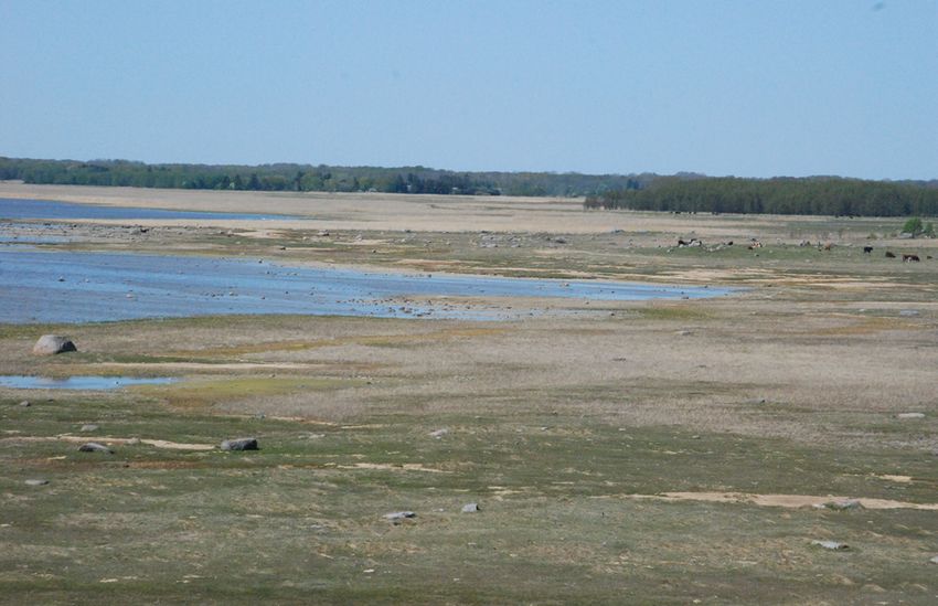
G R E E N   I N F R A S T R U C T U R E   A N D   N E T W O R K    C O H E R E N C E
  25

                                                                                                                        Citation
                                                                                                                        Chapter B.II: Van der Sluis, T. & Jongman, R. (2021):
II.1 Introduction                                                                                                       Green Infrastructure and network coherence. In: Van
                                                                                                                        der Sluis, T., Schmidt, A.M. (2021). E-BIND Handbook
                                                                                                                        (Part B): Scientific support for successful implementa-
                                                                                                                        tion of the Natura 2000 network.
This chapter on ‘network coherence’ discusses the ‘network of protected areas’ and its physical
connections in the landscape. No natural or protected area stands on its own: natural areas are                         The whole document can be downloaded under
always somehow connected with surrounding areas, through physical connections (corridors)                               ecologic.eu/book/scientific-support-for-successful-
and species which move between areas. This is often called an ‘ecological network’.                                     implementation-of-the-natura2000-network

An ecological network consists of habitat patches for a population of a particular species that
exchanges individuals by dispersal.

The concept of ‘network coherence’ stems from landscape ecology, and is known by various                              An ecological network consists of habitat patches
terms, like landscape connectivity, a concept much used in ecological networks, and more recent-                      for a population of a particular species that
ly the wider concept of Green Infrastructure. These aspects are briefly explained and an overview                     exchanges individuals by dispersal.
is provided of the approaches in many European countries, as well as how the concept is embed-
ded in national or regional policies and strategies. Some inspiring examples are presented on
how these strategies have been developed at a local or regional level, to improve connectivity for
specific habitats and species.

II.1.1 The concept of network coherence and landscape connectivity
Biological diversity is highly dependent on the quality, quantity, and spatial cohesion of natural
areas. If wildlife is spread over a large area in small numbers, and if the remaining areas are
too small, sooner or later wildlife species will disappear.

                                                                                                                      Figure II.1
                                           Land use changes                                                           The concept of landscape fragmentation: with increasing
                                                                                                                      land use intensity, natural habitats are lost resulting in a
                                                                                                                      fragmented landscape with very limited habitat.
                                                                                         Land use intensity:          (Van der Sluis et al., 2011)
                                                                                         loss of biodiversity

                                                   Towards
                                                   sustainability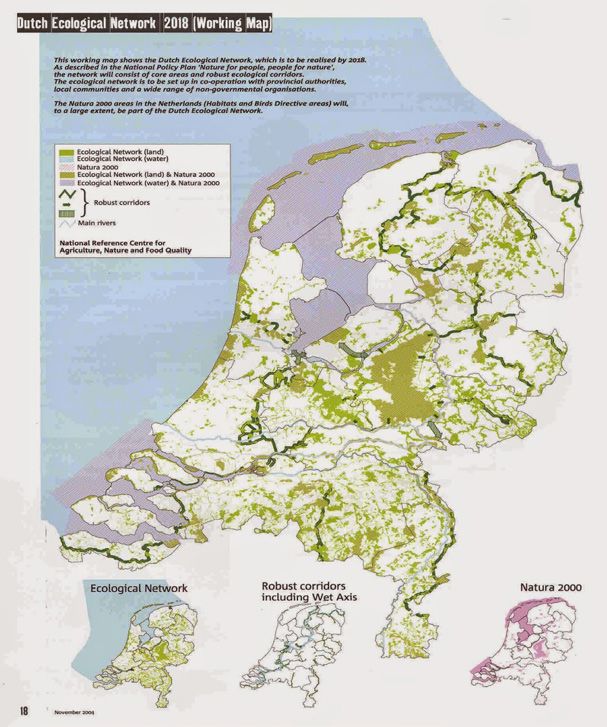
G R E E N   I N F R A S T R U C T U R E   A N D   N E T W O R K      C O H E R E N C E
  26

Due to intensive human use, Europe´s habitats are ‘fragmented’ and sometimes lost. Figure
I.1 illustrates the process of fragmentation of natural areas. Extensive natural areas (upper
scheme) have been changed over time by human activity such as deforestation. The suitable
land surface is decreased, or broken up into small habitat patches (lower scheme ”Figure I.1” on
page 25). Due to the fragmentation of their habitat, many species in Western Europe have
already disappeared or may disappear from several regions in the future. As natural areas are
fragmented, only small populations of species can survive in the small and isolated habitat
patches. Whether species survive or not, often depends on a fragile balance. For example a
number of bad years, an epidemic disease or a coincidence may result in the extinction of a
species*. However, good landscape connectivity will give species a better chance of survival in
the long term. Moreover, the impact of climate change, which may result in species and habitats
moving north in Europe, may be less severe if landscapes are well connected.

Landscape fragmentation severely affects the abundance of species. An answer to
this problem is improving network coherence, that is, strengthening of the ecological
network.

Network coherence is important in allowing for repopulating or restocking of small areas and
habitats, which is why areas need to be connected to the remaining core areas for wildlife in the
vicinity (Jongman et al., 2011; Snep & Ottburg, 2008). For birds, this means that the distance
from source areas to their habitat is less than the normal distance they might cover when flying.
For non-flying animals it might mean that a physical connection is required that functions as
a corridor, e.g. woodlands, streams, rivers, natural grasslands, and so forth (Van der Grift et al.,
2013; Van der Sluis et al., 2004).                                                                                       Options to improve landscape coherence
                                                                                                                         Basically, the options for improvement of landscape
The connectivity of the landscape for a species depends on the mobility of a species                                     coherence or landscape connectivity are:
and the type of the available habitat and its configuration in the landscape. Likewise,
for habitats it depends on the natural configuration of habitats, and inherent proper-                                   »   Through development or improvement of corridors
ties of the particular habitat. Corridors are very important for certain species. The connec-
                                                                                                                         »   Improvement may entail widening, adapting the
tivity is very much defined by species characteristics: range, habitat choice, dispersal distance,
                                                                                                                             vegetation to provide more cover for species, es-
carrying capacity. These species-specific characteristics cannot be changed. The landscape itself
                                                                                                                             tablishing water points or stepping stones etc.
can to some extent be adjusted. Also, each species requires a different type of corridor, and
corridor types can be linear, linear with nodes, stepping stones, or landscape mosaics.                                  »   Enlargement of core areas, conservation areas, by
                                                                                                                             enlargement and improvement of habitat
In addition to the ecological need for network coherence, there are also formal requirements in
the nature directives, in particular Article 10 of the Habitats Directive. This deals with the coher-                    »   Improvement of the ‘matrix’, the surrounding land-
ence of the Natura 2000 network and the management of nature outside the network. The legal                                  scape, e.g. through stimulation of low-intensity
aspects are discussed in paragraph II.1.2 Policy and legislation.                                                            farming, reduced use of agro-chemicals, or more
                                                                                                                             natural forest management for forest corridors,
The various concepts have been presented in guidelines such as the ‘European corridors: strate-
                                                                                                                             better conservation of the riverine vegetation and
gies for corridor development for target species’ (Van der Sluis et al., 2004) but also in various
                                                                                                                             avoiding expansion of human settlement.
brochures, papers and articles (Opermanis et al., 2011; Vos et al., 2001).5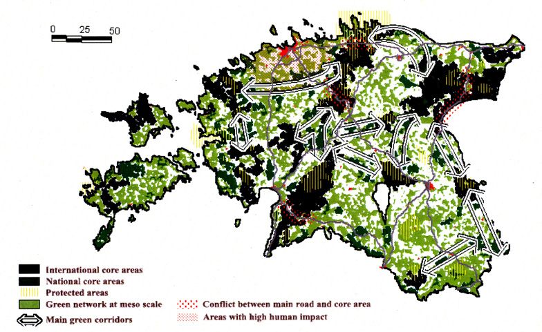
G R E E N I N F R A S T R U C T U R E A N D N E T W O R K C O H E R E N C E
27
Finally, one should be aware that a corridor for one species can be a barrier for another. A forest
corridor, or forest area which is a connection or habitat for a forest species, can be a barrier for
certain butterfly species or meadow birds that avoid forested areas. Therefore, one cannot speak
of ‘an’ ecological network, since it is species-specific. Development or improvement of landscape
or network coherence is always a matter of choices, certain species groups that measures are
aimed at or intended for.
What are ecological networks Figure II.2
An ecological network is a system of areas which are connected Schematic overview of an ecological network.
via ecological links or physical links. The ecological network usu- CORE AREA (after Bouwma, Jongman & Butovsky, 2002)
ally consists of ‘core areas’ (protected or not), corridors, buffer
LANDSCAPE CORRIDOR
zones and in some cases nature restoration areas. A pivotal role
in ensuring spatial cohesion of the network is therefore played
by corridors. Together with so-called ‘core areas’ corridors form BUFFERZONE
essential components of ecological networks. The network
coherence is an essential part of various strategies for ecological
CORE AREA
landscape planning.
LINEAR CORRIDOR
Ecological networks can be especially beneficial for large herbi- STEPPING STONE CORRIDOR
vores like the red deer and gazelle, or for top predators like the
wolf, leopard, lynx and otter. Corridors for large animals will also CORE AREA
benefit many small organisms as a result of improvements in
spatial cohesion and expansion of natural habitats.
RESTORATION AREA
What is Green Infrastructure
In the United States, the network concept was developed and re-
ferred to as ‘greenways’ (Ahern, 1995). Recently, the term coined
in EU policies for the same concept is ‘green infrastructures’.
By its nature, Green Infrastructure has a wider set of aims, or
ambitions than ecological networks. Green Infrastructure (GI) is a concept, not a set of rules, and
there are many interpretations of Green Infrastructure. GI is a spatial and functional structure
delivering nature benefits to people. The focus is on multifunctional use, whereby natural areas
can contribute to biodiversity conservation and other environmental functions.
Green Infrastructure is an approach ’... that brings together both the need for strategic planning
of green and open spaces and the science of ecosystem services. It promotes the multifunc-
tional nature of space and the benefits that appropriate management approaches can deliver.
It recognises the need to plan land use for specific purposes such as farming, nature protection
and development but also provides the tools and methods to identify needs and opportunities to
enhance the environment and its functions’ (John et al., 2019).
The three key GI principles are connectivity, multifunctionality and spatial planning. A recent
The three key GI principles are connectivity,
publication provides guidance on data, methods and tools to implement GI (Estreguil et al., 2019).
multifunctionality and spatial planning.
How to create a strategic design of a well-connected, multi-functional, and cross-border GI.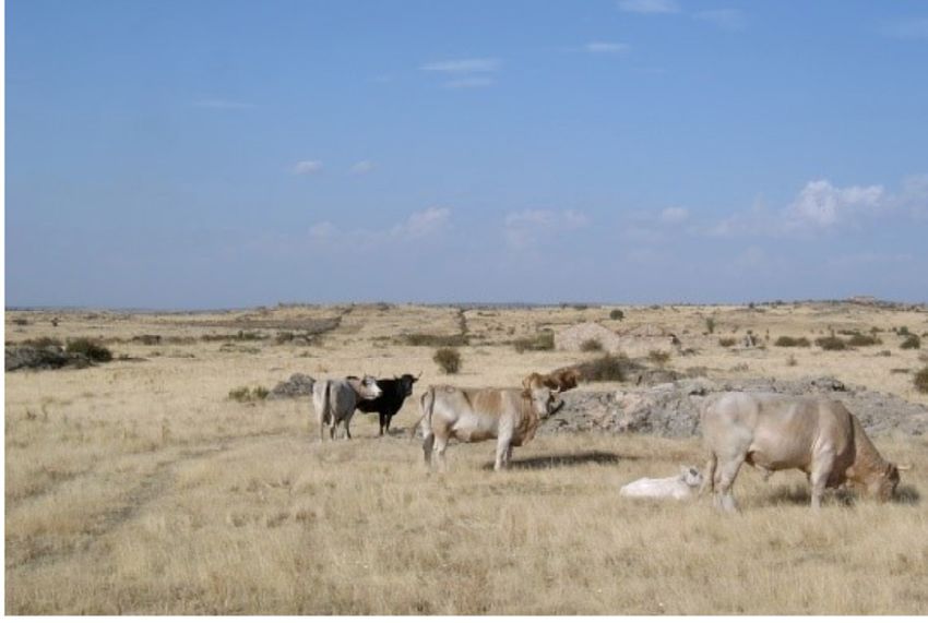
G R E E N   I N F R A S T R U C T U R E   A N D    N E T W O R K    C O H E R E N C E
  28

GI mapping has been demonstrated to enhance nature protection and biodiversity beyond protect-
ed areas, to deliver ecosystem services such as climate change mitigation and recreation, to prior-
itise measures for defragmentation and restoration in the agri-environment and regional develop-
ment context, and to find land allocation trade-offs and possible scenarios involving all sectors.

II.1.2 Policy and legislation
The development of ecological networks and corridors is recognized as a positive policy for pro-
moting nature conservation both at European and global levels (Jongman et al., 2011).

The Bern Convention aims at conserving wild flora and fauna and their natural habitats. As part
of its work under the Bern Convention the Council of Europe launched the so called Emerald                              The Birds and Habitats Directive art. 10
Network, an ecological network of Areas of Special Conservation Interest. To fulfil its obligations                     Article 10 of the Directive states: Member States shall
arising from the Bern Convention and to realise the Emerald Network the European Union set up                           endeavour, where they consider it necessary, in their
the Habitats Directive (Council Directive 92/43/EEC) and subsequently the Natura 2000 network.                          land-use planning and development policies and, in
                                                                                                                        particular, with a view to improving the ecological
Article 10 of the Habitats Directive is an important instrument to improve, where                                       coherence of the Natura 2000 network, to encourage
necessary, the ecological coherence within the context of the Directive and as a part                                   the management of features of the landscape which
of the national and regional ecological networks. Article 3.3 and 10 explicitly refer to con-                           are of major importance for wild fauna and flora.
nectivity in the wider landscape. A long-term target for the implementation of Article 10 should
be to identify the relationship between Favourable Conservation Status and connectivity. In this                        Such features are those which, by virtue of their linear
context species and habitats occurring outside Natura 2000 sites also need to be considered.                            and continuous structure (such as rivers with their
                                                                                                                        banks or the traditional systems for marking field
Green Infrastructure is of more recent date, and forms an important part of the European policy                         boundaries) or their function as stepping stones (such
agenda. It is specifically mentioned in target 2, Action 6 of the Biodiversity strategy, Our life in-                   as ponds or small woods), are essential for the migra-
surance, our natural capital: an EU Biodiversity Strategy to 2020 (European Commission, 2011).                          tion, dispersal and genetic exchange of wild species.
Target 2 of the Strategy mentions: ‘By 2020, ecosystems and their services are maintained and
enhanced by establishing green infrastructure and restoring at least 15% of degraded ecosys-                            In addition, Article 3 mentions under 3): Where they
tems’. Action 6 mentions: Set priorities to restore and promote the use of green infrastructure.                        consider it necessary, Member States shall endeavour
The Commission developed a Green Infrastructure Strategy to promote the deployment of green                             to improve the ecological coherence of Natura 2000 by
infrastructure in the EU in urban and rural areas, including through incentives to encourage up-                        maintaining, and where appropriate developing, fea-
front investments in green infrastructure projects and the maintenance of ecosystem services.                           tures of the landscape which are of major importance
                                                                                                                        for wild fauna and flora, as referred to in Article 10.
The EU biodiversity strategy 2030 highlights the importance of a coherent Trans-European Nature
network, and the need “ ...to set up ecological corridors to prevent genetic isolation, allow for spe-                  Furthermore, Article 4 of the Birds Directive states:
cies migration, and maintain and enhance healthy ecosystems” (European Commission, 2020). The                           Member States shall take similar measures for reg-
Strategy also mentions the ambition to unlock at least 20 billion a year for investing in Natura                        ularly occurring migratory species ..., bearing in mind
2000 and green infrastructure.                                                                                          their need for protection in the geographical sea and
                                                                                                                        land area where this Directive applies, as regards their
The following table gives an overview of the legal aspects of GI, and how it is protected in                            breeding, moulting and wintering areas and staging
national legislation in central Europe (John et al., 2019).                                                             posts along their migration routes.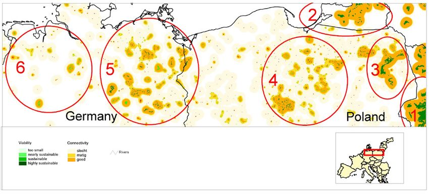
G R E E N    I N F R A S T R U C T U R E    A N D    N E T W O R K    C O H E R E N C E
 29

                                          Global or                                                                                         Table II.1
                                                                            AT                                                              Protection of Green Infrastructure (GI) or its Functionality
                                           regional                                                        DE                IT
Regulation Topic                        international
                                                            EU      AT    Lower          CZ     DE
                                                                                                         Saxony
                                                                                                                   IT
                                                                                                                         Piedmont
                                                                                                                                      PL
                                                                          Austria                                                           (F) by regulations, laws and policies at different levels.
                                         regulations                                                                                        (John et al., 2019)
Green Infrastructure
Green Infrastructure                                        GI     GI          GI       GI      GI                                   GI     EU        European Union
Protection of Nature,                                                                                                                       AT        Austria
Biodiversity and Landscape                                                                                                                  CZ        Czech Republic
Nature and Biodiversity Protection                                                                                                          DE        Germany
                                                                               GI       GI      GI        GI                         GI     IT        Italy
(in general)
  Biodiversity Protection                       GI          GI     GI                   GI      GI        GI      GI          GI            PL        Poland
  Species Protection                            GI          GI                 GI       GI      GI        GI      GI                 GI
  Invasive Species Management                               F                  F         F      F          F       F                  F
  Protection of areas/habitats                  GI          GI                 GI       GI      GI        GI      GI          GI     GI
Landscape Protection                                        GI                 GI       GI      GI        GI      GI          GI     GI
  Protection of Cultural and Natu-
                                                GI          GI                                            GI                  GI     GI
  ral Heritage
Environmental Protection
Prevention of harmfull Effects on
                                                            F                  F         F     F GI                F                  F
the Environment (in general)
  Environmental Liability                                   F       F          F         F      F                  F                  F
  Environmental Assessment
                                                F           F       F                    F      F          F       F           F
  (EIA/SEA)
Water Protection                                GI        GI F     GI                   GI     GI F      GI F     GI F         F     GI
Air and Climate Protection                                  F       F                    F      F          F                          F
Soil Protection                                             F                  F         F      F          F       F           F      F
Economy and Sustainable
Development
Agriculture                                                 GI                 GI       GI      GI        GI                         GI
Forestry                                                    GI     GI          GI       GI      GI        GI      GI          GI     GI
Hunting and Fishing                                       GI F             GI F         GI F   GI F      GI F      F          GI F   GI F
Tourism and Recreation                          GI          GI                 GI       GI      GI        GI      GI
Energy                                                      F       F                    F      F          F                          F
Sustainable Development                                     F       F                    F      F          F       F                  F
Spatial Planning
Regional and Local Planning                                 F                  F        GI F   GI F      GI F                 GI F   GI F
Urban Planning                                              GI                 F        GI      GI        GI      GI          GI     GI
Sectoral Planning                                           F     GI F         F         F      F          F                  GI F   GI F
Access to Information on the Envi-
                                                F           F       F          F         F      F          F       F           F      F
ronment and Public Participation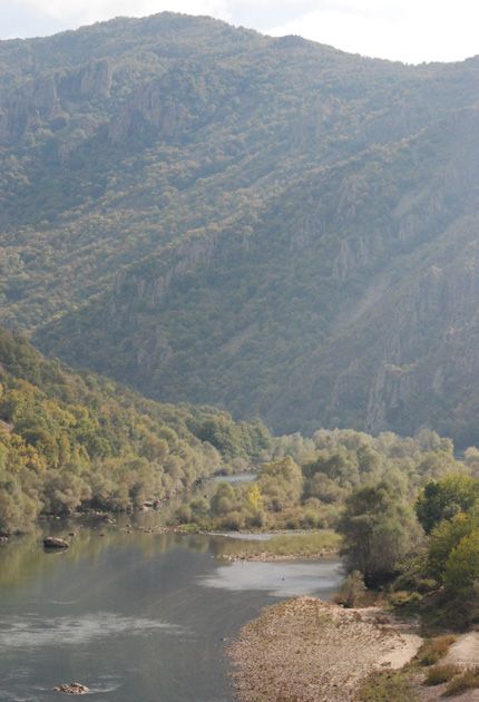
G R E E N   I N F R A S T R U C T U R E   A N D   N E T W O R K    C O H E R E N C E
  30

After the 1992 global summit in Rio de Janeiro, where the Convention for Biological Diversity
(CBD) was agreed upon, the Council of Europe initiated the Pan European Biological and Land-                           Federal states are not all organised in the same
scape Diversity Strategy (PEBLDS), making the planning of the Pan European Ecological Network                          way. In some countries (Austria, Belgium, Spain,
at European and national levels its first objective. Next to the European Birds directive, the Habi-                   UK) all power in the field of Nature Conservation is
tats Directive and PEBLDS, there are several global and European conventions that are important                        devolved to the lower 'regions', or 'Länder'. This can
for Connectivity conservation. These are the CBD, the Wetlands Convention, the Bonn Convention                         cause differences between regions within these coun-
on migratory species and the Bern Convention, on which the Habitats Directive is based.                                tries. It can also be a source of complex negotiations
                                                                                                                       as the national state is the point of reference for the
                                                                                                                       European Union, but in some cases without power to
II.2 Ecological networks and GI at national                                                                            carry out the requests from the European Union with-

     level                                                                                                             out internal coordination. In Germany the framework
                                                                                                                       legislation gives the Federation (Bund) the power to
                                                                                                                       make guidelines; for nature conservation, guidelines
II.2.1 Methods and approaches                                                                                          have been made in close cooperation with the mem-
                                                                                                                       ber states. This means that a national approach can
Political support for investing in conservation of biodiversity, including connectivity, has generally                 only be reached through negotiation and agreement
increased over time in Europe. Planning landscape connectivity and ecological networks is gener-                       between regions. In Italy tasks and responsibilities are
ally accepted in Europe, but in practice carried out in different ways due to political, geographical                  devided between the state, the regions and provinces.
and economic priorities. Germany, Austria, Italy and Spain are decentralized federal coun-                             In Austria the federation has no power in this field.
tries, while countries such as Denmark, the Netherlands, Portugal and the Czech Republic are
more centralized.                                                                                                      Unitary states maintain the formal responsibilities
                                                                                                                       for nature conservation at the national level, although
Political support for investing in conservation of biodiversity, including connectivity, has generally                 it is also possible that part of the main executive
increased over time in Europe. Building road- and railway crossing structures for species and                          and the implementation of tasks have been delegat-
habitats' connectivity depends on funding from the transport sector at European and nation-                            ed to the regions. In most countries where national
al levels, and joint planning by transport agencies and conservation planners. The European                            responsibility is dominant, the Ministry of Environ-
Commission promotes environmentally-friendly infrastructure building through its                                       ment is responsible. In a number of cases, however
co-funding programmes so that wildlife bridges are often included in road projects.                                    the Ministry of Agriculture is responsible, such as in
Funding for connectivity conservation is partly provided by the European Commission, partly by                         the Netherlands and Greece. In Greece the Ministry
national or regional governments and funds. Funding is project-driven and initiated by national                        of Agriculture is responsible for the management of
and regional governments or NGOs. Cooperation depends on willingness and priorities across                             National Parks and all forested areas in general, spe-
borders.                                                                                                               cies protection, the supervision of issues on fisheries,
                                                                                                                       hunting, forestry, agriculture, genetic resources, ex situ
                                                                                                                       plant conservation and domestic animals.
II.2.2 Regional approaches for Network coherence
This paragraph summarizes regional approaches. Detailed descriptions of how national policies
evolved over time can be found in the detailed country descriptions, which are accessed through
the links in the text.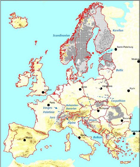
G R E E N     I N F R A S T R U C T U R E      A N D    N E T W O R K   C O H E R E N C E
  31

Former Soviet Union countries
National connectivity plans had already been written in Eastern Europe in former Czechoslovakia
and the former Soviet Union, including the Baltic states, with the general objective of landscape
ecological stability (Mander et al., 1988; Bucek et al., 1986; Bucek et al., 1996). For all three
Baltic countries, ecological networks have been developed at national, regional and local scale.
They have been published together under coordination of the IUCN office for Central Europe.

The approach is illustrated by the case of the conservation history for Estonia. The principles
of the ecological network were first applied in Estonia in the 1960s, when it was tried
to regulate the use and planning of natural resources. In the years 1979–81 the state
ordered “The outline for the protecting and sustainable use of Estonian natural resources”. The
Physical Geography Department of the University of Tartu developed the idea of the ecological
network of Estonia, the so-called system of ecologically compensatory areas. These areas were
handled as parts of a cultural landscape that mitigated the anthropogenic influence on the
landscape. The map of Estonian compensatory areas with the explanatory letter was ratified as
a basis for planning and developmental action until the year 2005.

Determining the green network was one of the chapters in national planning “Estonia – vision
2010”. It suggested that core areas should be determined on the basis of at least two aspects:
area and value. Natural regions comprising compact natural territories with an area of at least
100 km² were defined as core areas of international importance. ‘Compact’ regions with a ter-

                                                                                                                             Figure II.3
Estonia 2010 Green Network
                                                                                                                             Network of ecologically compensating areas of Estonia.
                                                                                                                             (Mander et al., 2003)

                 International core areas
                 National core areas
                 Protected areas
                 Green network at meso scale        Conflict between main road and core area
                 Main green corridors               Areas with high human impact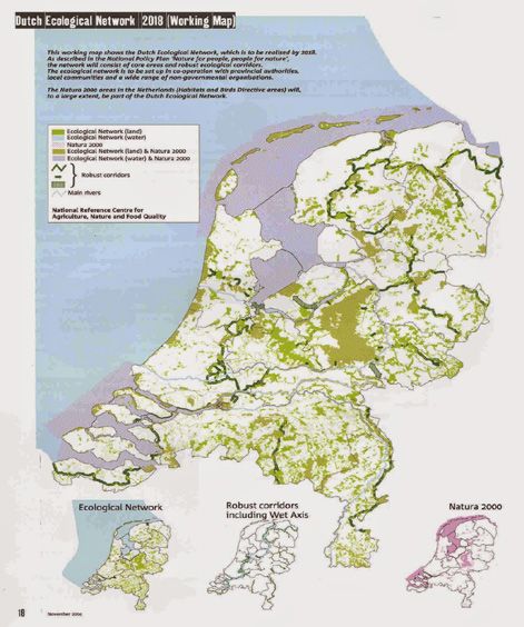
G R E E N   I N F R A S T R U C T U R E   A N D   N E T W O R K   C O H E R E N C E
  32

ritory of at least 15 km2 are defined as core areas of national importance. As areas of national
importance are situated in between the areas of international importance, it is possible to mark
the most important ‘green corridors’ of the network, which constitute convenient dispersal
routes for species between the core areas.

Networks of ecologically compensating areas should fulfil the following main ecological and
socio-economic functions in landscapes: biodiversity, material and energy flows, socio-economic
development (e.g. recreation) and cultural heritage.

Former Eastern Bloc countries of Central Europe
The concept of ecological networks and its application in the planning practice in former Czecho-
slovakia and later in Slovakia as well as in the Czech Republic was formulated as the territorial
system of ecological stability TSES. The main purpose of the establishment of the ecological
networks approach is the preservation of spatial ecological stability of the landscape. The con-
cept of TSES started in 1970 and was a pioneering ecological network at national, regional and
local levels. It was one of the first comprehensive concepts of this kind (Miklos et al., 2011). It
represents a hierarchical connectivity concept of ecological core areas (biocentres) of different
importance connected by biocorridors.

TSES projects in Slovakia were carried out top-down, from the General Plan of supra-region-
al TSES, through regional to local TSES. Following the General Plan, the National Ecological
Network (NECONET) was set up based on the concept of the European Ecological Network and
building on principles of the Dutch National Ecological Network. The regional TSES (RTSES) have
been developed in the years 1993–1995 for all 38 regions at a scale of 1:50,000. When Slova-
kia joined the EU, the European system of Natura 2000 was integrated in the TSES projects.

Also in the Czech Republic, landscape fragmentation is an issue of importance and maintenance
of corridors and landscape elements is an important aspect of the Czech nature conservation
policy. Not having been part of the nature policy in the 1980s, they have been integrated into
the TSES concept in the 1990s as Significant Elements of the Landscape (SLE) and legally
recognised (Act 114/1992). They are considered to be the “skeleton of ecological stability in the
landscape” and are partly legally protected.

Bulgaria has incorporated the ecological network concept in the Biological Diversity Act. This
Act regulates the protection of habitats, of species of plants and animals and their biotopes. It
introduces the requirements of the Habitats and the Birds Directives, focused on preservation
of habitat types and biotopes of plant and animal species. The Act on the Biological Diversity
envisages the establishment of National Ecological Network, consisting of three elements –
protected zones, protected areas and buffer zones. The rapidly growing road network in Bulgaria,
initiated by EU strategies to construct Pan-European Transport Corridors, results in increasing
conflicts with biodiversity objectives and the aim of a coherent Natura 2000 network. Therefore,
one of the big challenges at present is the mitigation of the fragmentation of the landscape by
roads and railways.
G R E E N   I N F R A S T R U C T U R E   A N D   N E T W O R K   C O H E R E N C E
  33

Unitary states
In Western European countries such as Denmark and the Netherlands, spatial planning for
connectivity conservation is regulated in spatial planning and nature conservation legislation
(Jongman et al., 2004; Van der Sluis et al., 2012).

The national ecological network in the Netherlands stems from 1990 (Ministry of Agriculture,
Nature Management and Fisheries, 1990). The Nature Policy Plan (Natuurbeleidsplan) presented
the National Ecological Network (Ecologische Hoofdstructuur, NEN). The aim of NEN is to develop
a coherent network of natural areas (core areas and nature development areas) that are con-
nected by ecological corridors. With this con-
                                                                                                                     Figure II.5
cept of NEN, the government launched a new
                                                                                                                     National Ecological Network of the Netherlands.
approach to nature conservation, replacing the
traditional protection of natural areas in their
original status with an active form of protec-
tion and nature development, setting clear
priorities in a wider (inter)national context.

2012, during the economic crisis, re-orienta-
tion and decentralisation of the national na-
ture policy took place. The original plan of the
NEN was abandoned and aims were reduced
to more or less the area that had been real-
ised at that moment. Coordination between
national and provincial authorities was needed
for realizing necessary connecting measures
for provincial roads for an optimal return on
investments. After the crisis, a renewed effort
was made to speed up the process of land-
scape defragmentation with the Netherlands
Nature Network with extra funds.

In the Netherlands, the owner and manager of
transportation infrastructure is responsible for
financing and implementing all ecopassages
(bridges and culverts). This is the main reason
why ecoducts and culverts were not imple-
mented in the 1990s.
G R E E N I N F R A S T R U C T U R E A N D N E T W O R K C O H E R E N C E
34
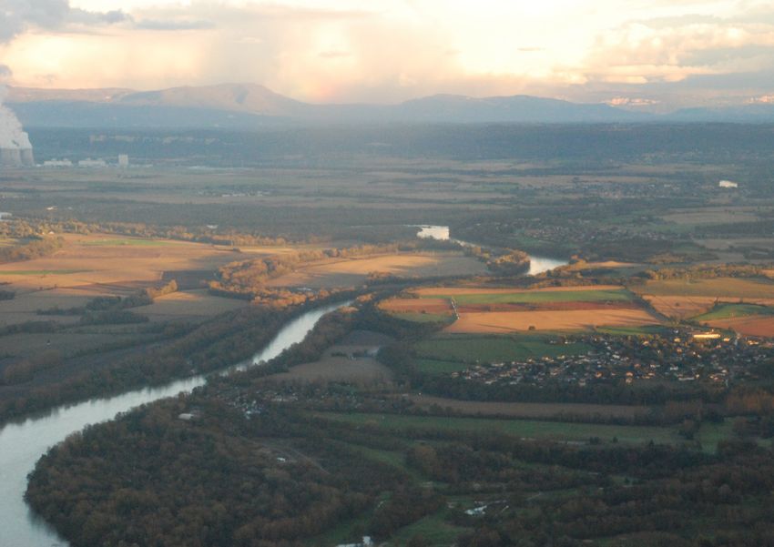
In 2007, the green and blue infrastructure (Trame vert et Figure II.5
blue, TVB) was launched in France. The TVB aims to maintain French ‘Trame vert-et-bleu’ or green-blue network.
and restore a green-blue network, to reduce habitat loss (source: Romain Sordello)
and fragmentation and to integrate biodiversity into urban
planning, in line with the EU Nature and Water Directives. SYNTHÈSE NATIONALE DES ENJEUX DE CONTINUITÉS ÉCOLOGIQUES RÉGIONALES
The green and blue infrastructure takes into account the
ecological functioning of ecosystems and species in land
use planning and focuses on ‘common’ biodiversity. The TVB
Source des données : Base nationale standardisée des données des Schémas régionaux de cohérence écologique. INPN, Octobre 2017.
consists of five subnetworks, e.g. the wooded subnetwork and
the wetland subnetwork. Based on national guidelines, re-
gional and local networks are being developed. Regional Eco-
logical Networks (REN) were designed with several methods
freely chosen by the regions (e.g. least-cost path). Barriers to
species movements (roads, dams, other infrastructure) have
been identified and plans for actions formulated to preserve
or restore the core areas and corridors.
Decentralized governments (federal states)
In contrast, in federal states like Spain, Germany, Italy,
Austria and Belgium, regional governments are given wide
latitude in spatial planning, with some guidance from federal
statutes.
In 2007, the Spanish Parliament adopted a new Nature
Réservoirs de biodiversité
Conservation Act (Ley 42/2007) which includes ecological Corridors écologiques
0 50 100 km
networks and ecological corridors. The Act defines ecological Cette carte restitue les continuités écologiques identifiées dans le cadre des travaux relatifs aux schémas régionaux de cohérence écolo-
gique (SRCE) en France métropolitaine (Corse exclue et à l'exception de la sous-trame des cours d'eau qui fera l'objet d'un travail spéci-
corridors as corridors connecting natural sites of special im- fique). Elle est indicative et ne tient pas compte de la validité des SRCE. Seuls les SRCE en vigueur ont une valeur réglementaire.
Éditée pour une impression au format A4, cette carte est le résultat d'un traitement des données régionales (issues de méthodes
portance for wild flora and fauna, allowing genetic exchange différentes) effectué pour permettre une restitution à l'échelle nationale.
Pour plus d’informations sur la méthode utilisée : BILLON L., GREGOIRE A., DUCHENE C., MUSTIERE S., LOMBARD A., SORDELLO R. (2017).
Réalisation d’une carte de synthèse nationale des continuités écologiques régionales. Rapport méthodologique. UMS Parimoine Naturel
between otherwise separated populations. Article 17 defines AFB-CNRS-MNHN, COGIT-IGN, Centre de ressources Trame verte et bleue. 33 pages.
ecological networks as networks of sites of high natural
value which allow the movement of flora and fauna species.
It also specifies that nature management plans have to con-
tribute to connectivity conservation and restoring corridors.
It mentions as important corridors: river courses, drove roads
(cañadas) and mountain ranges.
The different regions implement this Act in their own way, since there is regional autonomy. At
present there are three regions that have developed ecological network plans: Cataluña, Basque
Country and Madrid. In 1992 in Cataluña, the plan for spaces of natural interest (PEIN) was
created, which was the first coherent plan that delimits and establishes a conservation system
for the basic protection of representative natural spaces in accordance with their scientific,G R E E N I N F R A S T R U C T U R E A N D N E T W O R K C O H E R E N C E
35
Figure II.6
Very particular for Spain are the drove roads (cañadas)
for sheep, which form part of the ecological network. Here
the Cañada real de Segovia with grazing cattle. © Rob
Jongman
ecological, landscape and cultural importance. Studies were done on the improvement of the
ecological network, e.g. with the model LARCH (Franz et al., 2011). Later in the Basque country
(2005) and Madrid (2010) ecological networks were designed. However, the concept has not yet
been implemented. One of the important causes of delays seems to be the lack of resources.
Another problem is that regional planning is focusing on urban areas and town planning, and
that land use planning for rural areas is lacking.
NGOs are very important in pushing developments in Spain. For instance the Fundación Oso
Pardo which is developing with EU-Life+ funds connectivity for populations of the brown bear.
There are several associations involved in the use and protection of the Spanish cañadas as well
as groups dedicated to specific species, such as the Spanish Ornithological Society (Sociedad
Española de Ornitología).G R E E N I N F R A S T R U C T U R E A N D N E T W O R K C O H E R E N C E
36
Länderübergreifender Biotopverbund von Waldlebensraumkomplexen
The German federal nature conservation law, BNG, dates Stand: Juli 2010
Figure II.7
back to 1976 and its last revision is from 2009. One of the National important corridors and core areas for forest
major tasks in a federal state like Germany with devolved ecosystems.
responsibility for nature conservation is the integration of (Fuchs et al., 2016)
the state networks into a national ecological network. States
and federation work together on this under coordination
of the Federal Nature Conservation Agency (BfN). Through
landscape planning, nature conservation criteria can be tak-
en into account in planning and administrative procedures
and the ecological network be realised.
Defragmentation is an important issue in Germany. Work on
defragmentation is organised by the states in cooperation
with the Federal Nature Conservation Agency, consultants
and universities, such as the university of Kiel and the
university of Kassel. In the planning and realisation of linear
infrastructures (construction of new roads and expansion of
roads, railways, canals) the existing ecological interconnect-
edness is to be preserved in such a way that colonization
and repopulation of habitats by naturally-occurring species
can take place in sufficient numbers. Depending on the
affected habitats and species, special measures can then be
planned to preserve these network relationships.
In Italy, there are twenty-one regions with an increasing
autonomy. The state generally has a coordinating role. Each Bundesamt für Naturschutz
Quellen: Bundesamt für Naturschutz (BfN), 2011, Fuchs et al. 2010
region has to produce regional legislation and often provinc- CORINE Land Cover - Waldkulisse CORINE Land Cover 2006: Umweltbundesamt, DLR-DFD 2006
Flächen für den Biotopverbund (FBV) mit Waldachsen
es and municipalities issue local regulations. State, regions, länderübergreifender Bedeutung (Wälder)
ergänzende Achsen für Großsäuger
weitere Kernräume (Wälder) mit hohem
provinces, and municipalities all have responsibilities in Entwicklungspotential
managing parks and reserves at national, regional, provincial
and municipal levels. This means that regions draft regional
scale framework laws and regulations; local authorities such
as provinces and municipalities define rules for application. This situation regarding task sharing
allows much freedom for the different authorities to develop their own vision of nature conser-
vation and the development of ecological networks.
Territorial fragmentation and ecological connectivity have been studied and addressed within re-
gional authorities as well as within research institutes and universities. In 2003, ISPRA published
guidelines for the management of functional ecological connection areas, containing practical
information on the issues of conservation, planning and management of ecological corridors.
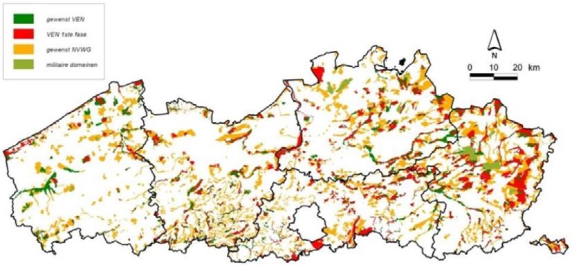
The LARCH model was used (Estreguil et al., 2019) to analyse the landscape and territory, andG R E E N I N F R A S T R U C T U R E A N D N E T W O R K C O H E R E N C E 37 with habitat modelling of target species an ecological network was proposed and partly imple- mented through regional initiatives and initiatives with project funding from LIFE and regional authorities. Several regional networks were developed, e.g. through the LIFE-Econet projects such as for parts of Emilia Romagna (Van der Sluis et al., 2001; Van Rooij et al., 2003), Abruzzo (Van der Grift & Van der Sluis, 2003; Van der Sluis et al., 2003) and Umbria (Van der Sluis & Pedroli, 2004). In Austria, there is no federal law establishing a framework for detailed nature conservation legislation by the Länder. Most of the connectivity restoration activities are carried out jointly by the states and NGOs such as the Alpen-Karpaten corridor and initiatives for stream restoration. In Belgium, the Flemish government is leading the process of developing a Flemish Ecological Network. The Flemish Decree on Nature Conservation (1997) defines the Flemish Ecological Network with core areas and nature development areas (VEN) as well as Integrated Multi- functional and Supporting Network with nature corridors (IVON). A target for the VEN is to protect 125.000ha (9.3% of Flanders). The nature integration areas (IVON) are supposed to cover 150.000ha. The Flemish Decree on Physical Planning aims to incorporate nature conser- vation targets (VEN, IVON) into physical planning objectives. The provinces have the respon- sibility to realize ecological corridors. Approximately 14 years after the date that was set in the Nature Decree and eight years after the target year in the IVON, 3% (around 5,084ha) has been demarcated. In the stage of realization of individual projects, informal cooperation with private stakeholders has to be established. This is partly done for the nature restructuring projects where landown- ers, farmers, hunters etc. are involved and persuaded into a ‘nature-friendly’ management. For the realization of the corridors, cooperation on a voluntary base is the rule. The negotiations between sectors and their legal bodies on the level of the administration in charge (nature con- servation, agriculture and forestry) are time consuming.
G R E E N   I N F R A S T R U C T U R E   A N D   N E T W O R K     C O H E R E N C E
  38

II.3 Implementation of GI at site/regional
     level
II.3.1 Methods and approaches
In some cases very simple fragmentation indices are used to design measures for defragmen-                              Network coherence is often addressed on the basis of:
tation, e.g. the use of Fragstats (Mcgarigal et al., 2002). These are generally not very suitable for
ecological network or GI purposes, since they are too generic and the output of indices mostly                          »   assessment of landscape fragmentation, through
says something about the map quality. Results cannot be generalized for planning.                                           indices
                                                                                                                        »   assessment of functionality of the landscape for
The functionality of the landscapes for species is an essential aspect for species' surviv-                                 particular species or ecosystems
al. Various model approaches analyse the dynamics of species populations living in ecological                           »   assessment of corridors
networks. Such dynamics are determined by (a) the number of individuals that on average live
in the network (carrying capacity), which is a function of habitat quality and network area, and
(b) the spread or dispersal of individuals across the network (connectivity), which is a function
of the network density and the permeability of the landscape matrix in which the network is
embedded (Opdam et al., 2002).

To perform a landscape analysis of sustainability of (meta)populations the model LARCH was
developed. The parameters were calibrated for species and ecosystems in the Netherlands
(Foppen et al., 1999; Verboom et al., 2001; Verboom & Pouwels, 2004). The LARCH model was
applied in many different countries and regions where case parameters were adjusted according
to the local conditions, for example in North-West Europe, Poland, the Meuse Basin, the river
Rhine, Abruzzo, Umbria and Emilia Romagna regions in Italy, Catalunya in Spain, Israel and
Ukraine (Franz et al., 2013; Franz et al., 2011; Geilen et al., 2001; Groot Bruinderink et al., 2003;
Pungetti & Van der Sluis, 2002; Van der Sluis et al., 2007; Van der Sluis & Van Eupen, 2013).

The assessment of corridors requires specific tools or models, which define how well-con-
nected the landscape is. Currently, there are no dedicated standalone tools that can be
used to assess the spatial distribution of GI. Applied GI projects are based on a compilation
of spatial and analytical tools that have been developed for quantifying and analysing habitat
aspects of interest to GI deployment. Instead, practitioners must be able to use standard GIs
and environmental systems analysis tools (Estreguil et al., 2019).

Specific methods or tools exist such as QuickScan (Van der Sluis et al., 2015; Verweij et al.,
2016), as well as free software packages, such as GuidosToolbox, Linkage Mapper, or Cone-
for (Estreguil et al., 2019; Saura & Torne, 2009). Free tools now available enable assessment
at multiple scales, i.e. from local to regional, but also at European and global scales, due to
increased computational capacities.
G R E E N I N F R A S T R U C T U R E A N D N E T W O R K C O H E R E N C E
39
II.3.2 Financial instruments
The LIFE program
Financing of measures for Green Infrastructure is possible through the Natural Capital Financing An important source of funding for
facility. This facility is in particular meant to halt the loss of biodiversity and adapt to climate improving Green Infrastructure and
change. To do so, the European Investment Bank (EIB) and the European Commission have network coherence is the LIFE-
partnered to create the Natural Capital Financing Facility (NCFF), a financial instrument that Nature program. In the past the program has been
supports projects delivering on biodiversity and climate adaptation through tailored loans and funding activities related to improving the connectivity
investments, backed by an EU guarantee. for large carnivores, removing barriers for raptors
migration, ensuring river connectivity, transnational
II.3.3 Example studies for improving network coherence planning etcetera. The program will continue in the
period 2021–27 with an increase of almost €2 billion
A number of examples based on LIFE or Interreg projects are presented on how measures were from the present LIFE program.
prepared for improvement of the coherence of habitats, as well as for specific species. The spe-
cies' habitats described are selected based on their need for spatial coherence; various criteria In particular the following LIFE programs might be
were used to define priority habitats that are in unfavourable conservation status and require relevant, but check the ec.europa.eu/easme/en/life for
landscape coherence (Van der Sluis & Bouwma, 2019). The descriptions below are largely based up-to-date information:
on the examples in this study (with permission of ETC-BD). The criteria also include the potential » Regular LIFE+ Nature & biodiversity: funds
for habitat restoration. The selected species are flagship species, which may stimulate conserva- projects and local activities from various partner
tion and benefit the ecosystem and a wider set of species. organisations and NGOs;
Habitats and network cohesion » Integrated projects: implements e.g. the Priority
Action Frameworks and River Basin Manage-
a. Boreal Baltic coastal meadows (1630*) ment plans. Projects are large scale; payment of
complementary actions with additional co-funding;
Ecology and distribution requires involvement of stakeholders;
The ‘Boreal Baltic coastal meadows’ are characterized by low-growing plant communities. They » Strategic Nature Projects (SNaPs): Main-
occur in the geolittoral zone and are sometimes interspersed with salt patches. Characteristical- streaming of nature and biodiversity into other
ly the vegetation occurs in distinct zones, with saline vegetation closest to the sea. The salinity policies and programmes through coherent
is low since tide hardly exists, but they can be affected by land upheaval. programmes of actions in the Member States, in-
cluding institutional support. Beneficiaries are the
The habitat is widespread along the Baltic coast of Estonia, Finland and Sweden, rare in Latvia
competent nature/biodiversity authorities, in part-
and absent from Lithuania. Estonia reported the largest habitat area. Of the approximately 190
nership with relevant stakeholders (there is also a
km2 of this habitat in the Boreal region, about 78% is included in Natura 2000 sites.
possibility of funding for transborder SNaPs).
Land use in this zone consisted historically mostly of grazing and mowing, which resulted in a
gradual expansion of the habitat, keeping the vegetation low and open and rich in vascular plants.
Important bird species which depend on this habitat type and adjoining lagoons (Habitat 1150)
are Birds Directive Annex I species Eurasian bittern (Botaurus stellaris), as well as several Annex
II species, including Black-tailed godwit (Limosa limosa), Common redshank (Tringa totanus),
Mute swan (Cygnus olor), Eurasian coot (Fulica atra), Northern lapwing (Vanellus vanellus) and
Common snipe (Gallinago gallinago). Also the Dunlin (Calidris alpinas schinzii), Ruff (Philomacus
pugnax) and other meadow wader species breed here, and a grassland passerine communityG R E E N I N F R A S T R U C T U R E A N D N E T W O R K C O H E R E N C E
40
is present. A large number of waders of different species, as well as migrating geese and other
waterfowl are present during passing migration (Rūsiņa et al, 2017). In moister areas, large A number of examples based on LIFE or Interreg
sedge tussocks are preserved, which are important for birds. This also indicates that the scale projects are presented below on how measures
of the area and variety of habitats defines the completeness of bird assemblages (Rūsiņa et al., were prepared for improvement of the coherence of
2017). habitats, as well as for specific species:
Coastal meadows are valuable habitats for a large diversity of invertebrate species, in particular » Boreal Baltic coastal meadows (1630*)
nectar-feeding species and grassland species associated with animal excrement. One of the few » Alpine rivers and their ligneous vegetation with
endemic insects found in Estonia, Aeschna osiliensis, is specifically associated with coastal mead- Myricaria germanica (3230)
ows and other coastal habitats. Seaweed mounds and salinas are home to an unconventional » Temporary Mediterranean ponds (3170*)
community of predatory beetles. Shallow water bodies that appear in coastal meadows provide » European sturgeon/Beluga (Huso Huso) (HD App. V)
habitat for the rare large white-faced darter (Leucorrhinia pectoralis). In coastal meadows there » Large copper (Lycaena dispar) (HD App. II, IV)
are various dragonflies and species of homoptera, auchenorrhyncha and heteroptera. Areas with » Eurasian lynx (Lynx lynx) (HD App. II, IV)
a long-standing grazing tradition feature sods generated by ant species of Lasius and Myrmica. » Stag beetle (Lucanus cervus) (HD App. II)
The flora of Baltic coastal meadows is very rich, e.g. in
Estonia a total of 390 plants species have been found,
which is 26% of all Estonian species. More than 20
protected plant species grow on coastal meadows, in-
cluding many orchids: Dactylorhiza ruthei, Frog orchid
(Coeloglossum viride), Fen orchid (Liparis loeselii), Bal-
tic orchid (Dactylorhiza baltica), Blood-red dactylorhi-
za (Dactylorhiza incarnata ssp. cruenta), Early marsh
orchid (Dactylorhiza incarnata), Musk orchid (Hermini-
um monorchis), Marsh helleborine (Epipactis palustris),
Early-purple orchid (Orchis mascula), Common spotted
orchid (Dactylorhiza fuchsii), Military orchid (Orchis
militaris), Fly orchid (Ophrys insectifera) and Fragrant
orchid (Gymnadenia conopsea) (Anonymous, 2011).
Figure II.8
Coastal meadows at Väinamere, Natura 2000 site
EE0040002 Estonia. © Theo van der SluisG R E E N I N F R A S T R U C T U R E A N D N E T W O R K C O H E R E N C E
41
Proposed measures for GI
Appropriate management is the main proposed measure for maintenance of grasslands. Other Conservation status
proposed measures include the establishment of protected areas and improvement of legisla- The conservation status of this habitat type is unfa-
tion. The ‘Natureship project (2009–2013)’, was financed by the EU Central Baltic Interreg IV A vourable-bad, based on the assessment in all Member
Programme 2007–2013 and national funding providers. The project had two focus areas: ”Water States except Estonia which reported unfavourable-in-
protection and coastal planning” and ”Biodiversity and cultural landscapes”. The project activi- adequate. The range is favourable in all countries,
ties targeted coastal areas in Finland, Sweden and Estonia. A total of eleven organisations have but other parameters are poor or bad for most of the
been involved in project implementation. Lead partner was the Centre for Economic Develop- region. In Sweden the bad situation is stable.
ment, Transport and the Environment in Southwest Finland, with other partners from Finland
Problem
such as Metsähallitus, the University of Turku, municipalities, from Estonia the Environmental
Inappropriate land use, particularly the abandonment
Board of Estonia and University of Tartu, and from Sweden the County of Gotland and Norrtälje
of agricultural management (grazing and mowing)
Nature Conservation Foundation.
represents the major pressure to this habitat type.
The goal of the project was to increase cooperation in habitat management and water protec- Abandonment of traditional management results
tion in the Central Baltic operating area. The most important objective of the Natureship project in encroachment, which causes a decline in bird
was promoting interdisciplinary coastal planning following the principles of sustainable develop- populations: grasslands smaller than 10 ha, will hold
ment. The aim of integrated coastal planning is to find solutions that will benefit all users of the no waders and the passerine community may be
area over the long term, taking natural values into account. It aims at finding the best cost-effi- incomplete. Pressures with less intensity are recre-
cient methods for water protection and biodiversity and rating ecosystem services. ation, sport and water pollution. Finland informed that
Article17_Consultation_Habitats_Map_WM dredging/ removal of limnic sediments and dumping
http://discomap.eea.europa.eu/map/Filtermap/?webmap=9de351f9399...
The project has promoted conservation cooperation between these areas and and depositing of dredged deposits are threats.
the exchange of experiences in habitat and species management. Ecosystem
service thinking plays a role in the planning and implementation of manage-
ment measures. The project aimed at finding win-win solutions that benefit
all: nature, water protection, local farmers and entrepreneurs, as well as
Figure II.9
inhabitants. Special emphasis was placed on Natura 2000 areas.
Distribution of Baltic Coastal meadows.
Assessment of ecosystem services (Halada, Aronsson, & Evans, 2016)
Ecosystem services related to the proposed measures, as described above,
are discussed in the chapter B.III and presented in Table III.3.
The Boreal Baltic coastal meadows are maintained through livestock herds
which as part of agro-ecosystems have different outputs: reared animals
and their resources, hay and possible other wildlife. ES include the supply
of nutrition and other renewable natural resources as well as
occurrence of natural ecosystem processes, maintenance of water
resources and circulation of nutrients. The meadow ecosystem protects
the coast against erosion, floods, and does some climate regulation, but the
meadows also maintain pollinator populations and livestock will facilitate
seed dispersal. Ecosystem services also include recreational use of
nature and the experiences obtained there, as well as residential ser-
vices, and inspirational services.G R E E N I N F R A S T R U C T U R E A N D N E T W O R K C O H E R E N C E
42
b. Alpine rivers and their ligneous vegetation with Myricaria germanica (3230)
Ecology and distribution
The habitat of Alpine rivers holds plant communities of low shrubby pioneers invading the her-
baceous formations on gravel deposits rich in fine silt, of mountain and northern boreal streams
with an alpine, summer-high flow regime. These deposits are usually dynamic, often being de-
stroyed and recreated in floods. German tamarisk Myricaria germanica and Willow species Salix
spp. are characteristic species of the ‘Salici-Myricarietum’.
The habitat type is typical for the Alpine biogeographical region, and most of the habitat is
found in the Alps and Carpathians; an isolated occurrence is reported from northern Finland.
The habitat usually occurs in small patches; the overall habitat area is quite small as well. In
Germany, Poland, and Slovenia the entire national habitat area is located in Natura 2000 sites;
in Austria and Finland a large part of the national habitat area is located in Natura 2000 sites.
Figure II.10, left
Alpine River, Most Arda, Natura 2000 site BG0002071
Bulgaria. © Theo van der Sluis
Figure II.11, right
Distribution of Alpine Rivers (note that the 2017 report
did not include Croatia at the time, so its habitats are not
included in the figure).
(Halada, Aronsson, & Evans, 2017)G R E E N I N F R A S T R U C T U R E A N D N E T W O R K C O H E R E N C E
43
Proposed measures for GI
A larger project looking at the river basin as a whole, is the DRAVA LIFE – Integrated River Conservation status
Management (LIFE14 NAT/HR/000115), a Croatian project with involvement of WWF-Austria. The overall conservation status of this habitat type in
The project foresees three transnational conservation actions, which involve stimulation of more the Alpine biogeographical region is unfavourable-bad
natural river dynamics, decrease of human impact, increase of inter-sectoral river management (and deteriorating). There has been no change in con-
and cross-border cooperation along the Drava river. servation status since 2001–2006.
Assessment of Ecosystem Services Problem
Ecosystem services related to the proposed measures, as described above, are discussed in The habitat has become rare due to river engineering.
chapter Ecosystem Services and presented in Table III.3. The Alpine river habitat is restored All countries reported a broad range of pressures,
through reversal of engineering works, removal of dams etc. This has limited potential for the most important being sand and gravel extraction,
provisioning services, much more for regulating services like erosion protection, flood protection canalisation, water deviation, modification of hydro-
and maintenance of nursery populations and habitats (in particular fish species). Some cultural graphic functioning, and modification of structures on
services are related to outdoor recreation, as well as inspiration. inland water courses (e.g. small hydropower projects
and weirs). Other important pressures are vegetation
succession, waste disposal, water pollution, invasive
c. Temporary Mediterranean ponds (3170*) non-native species, removal of sediments, flooding
Ecology and distribution modifications, lack of flooding, surface water abstrac-
Mediterranean temporary ponds are seasonal wetland habitats, subjected to extreme and tion, and construction of dykes and embankments.
unstable ecological conditions. Temporary Mediterranean shallow ponds are very shallow (a
few centimetres deep) and exist only in winter or late spring. Mediterranean Temporary Ponds
provide the microhabitats for crustaceans, macro-invertebrates, amphibians and reptiles. The
flora is mainly composed of Mediterranean therophytic and geophytic species of the alliances
Isoetion, Nanocyperion flavescentis, Preslion cervinae, Agrostion salmanticae, Heleochloion and
Lythrion tribracteati (Janssen et al., 2016).
Mediterranean temporary water bodies occur in very small stands. Temporary ponds appear in
depressions during the first rain events in the hydrological year. Rainwater accumulates due to
the less permeable soil layer underneath the pond, which retains the rainwater. The first flooding
ends up infiltrating and/or evaporating. These ponds are hydraulically connected to the ground-
water and from the moment the water reaches and surpasses the base elevation of the pond
the water retention period becomes longer. Therefore, the hydroperiod of most of these ponds is
higher than the one corresponding to simple accumulation of rainwater in soil depressions with
low permeability.
The salinity and hydroperiod are probably the most important community structuring factors, in
particular for the active and dormant crustacean communities. The aridification as a result
of climate change may lead to a loss of species that come late in the succession,
while salinisation may lead to the loss of already fragile freshwater species. Although
resting egg banks can temporarily buffer against unfavorable conditions, persisting bad condi-
tions may lead to their extinction.G R E E N I N F R A S T R U C T U R E A N D N E T W O R K C O H E R E N C E
44
Proposed measures for GI
The most important conservation measure reported in the Art. 17 reporting is the establishment Conservation status
of protected areas/sites and legal protection of habitats and species. Additional measures might Temporary Mediterranean ponds are assessed as
be to set out management rules for maintaining a favourable conservation status of temporary unfavourable-inadequate in three regions, as stable in
ponds; also the demonstration of ecological restoration techniques and measures could inspire the Mediterranean and Macaronesia and improving in
countries and managers to take action. Another measure is creating a seeds bank specifically the Atlantic together with unfavourable-bad (deteri-
for this habitat, which can be used in restoration actions and for the safekeeping of genetic orating) in the Continental region and unknown in the
reference for the flora of the habitat. Alpine region (Apennines).
We must consider these habitats as ‘communicating’ networks, whereby regular exchange takes Problem
place. The habitats are particularly vulnerable because they are small, dynamic and ephem- Most important pressures and threats mentioned in
eral. It is therefore important to maintain or improve the connectivity between these habitats. the article 17 reporting are changes in hydrology and
This requires the protection of existing ponds against destruction, restoration of destroyed or pollution. Over the last two decades, also changed
overgrown habitats and the creation of new habitats in particular where this would support the land use such as modern industrialised agriculture
network of ponds. and tourism have caused a steep decline in the
condition of this habitat type. Temporary ponds are
The Project LIFE+ ‘Conservation of Temporary Ponds on the Southwest Coast of Portugal’ subjected to strong anthropogenic pressures, such as
(LIFE12NAT/PT/997), LIFE CHARCOS, coordinated by the ‘Nature Protection League (LPN), pro- deep soil turning, accelerated drainage, change of the
motes the conservation of the Mediterranean Temporary Ponds. Among the practical activities surface topography or transformation of ponds into
that were carried out, the following might be relevant for replication elsewhere: permanent reservoirs for irrigation.
» Construction of temporary ponds, planting shrubs on the margins of ponds and creating Not featuring much in the Art 17 reporting (yet) but
shelters from stone and wood to promote habitat connectivity for amphibians, mammals, increasingly important in the near future will be cli-
reptiles and other biological groups in the pond complex. mate change. Increased temperatures combined with
more irregular precipitation will probably result in a
» Eradication of exotic plants, shrub control. shorter hydroperiod, loss of species and fragmenta-
» Rehabilitation of ponds with replacement of the natural relief with slight sinking and re- tion of habitat and dependent communities. Urgent
placement of the upper organic horizon to ensure the safeguard of the seeds and cysts of action is needed in order to assure their long-term
the species of the temporary ponds. protection.
» Re-introduction of species.
» Removal of drainage ditches.
The Life PRIMed (LIFE17 NAT/GR/000511) promotes restoration of temporary ponds in the Greek
Nestos Delta. Restoring the habitat includes the clearing of the vegetation that covers and falls
into the temporary ponds. The shrub removal is necessary for the survival of the species Emys
orbicularis, Testudo hermanni and Callimorpha quadripunctaria, present in these habitats. En-
largement of the habitat 3170* area is necessary due to the reduction of the total pond surface
area that has occurred during the last 20 years.You can also read