BIOPH YSI CAL CRI TERI A: PROTECTED AREAS AN D M ARI N E PROTECTED AREA N ETWORKS TO BEN EFI T PEOPLE AN D N ATURE - USAID SEA
←
→
Page content transcription
If your browser does not render page correctly, please read the page content below
BIOPHYSICAL CRITERIA:
DESIGNING MARINE
PROTECTED AREAS AND
MARINE PROTECTED AREA
NETWORKS TO BENEFIT
PEOPLE AND NATURE
IN INDONESIA
Harvesting trochus at sasi opening in Kapatchol Village, West Misool (Raja
Ampat). Image © Awaludinnoer, TNC
BIOPHYSICAL CRITERIA:
DESIGNING MARINE
PROTECTED AREAS AND
MARINE PROTECTED AREA
NETWORKS TO BENEFIT
PEOPLE AND NATURE IN
INDONESIA

Prepared by The Nature Conservancy (TNC) Indonesia Oceans Program
for the USAID Sustainable Ecosystems Advanced (SEA) Project
in collaboration with the Directorate for Marine Conservation and Biodiversity
of the Ministry of Marine Affairs and Fisheries, Republic of Indonesia
2020
BIOPHYSICAL CRITERIA: DESIGNING MARINE PROTECTED AREAS AND
MARINE PROTECTED AREA NETWORKS TO BENEFIT PEOPLE AND
NATURE IN INDONESIA
This publication was jointly produced by the USAID Sustainable Ecosystems Advanced (SEA) Project and the
Ministry of Marine Affairs and Fisheries, Republic of Indonesia.
USAID SEA Project Office
Sona Topas Tower, Floor 1 6, Jl. Jendral Sudirman Kav. 26, Jakarta 1 2920, Indonesia
  Chief of Party: Alan White, PhD (Alan.White@SEA-Indonesia.org)
   Deputy Chief of Party: Tiene Gunawan, PhD (Tiene. Gunawan@SEA-Indonesia.org)

Ministry of Marine Affairs and Fisheries Directorate for Marine Conservation and Biodiversity
Gedung Mina Bahari 3 Lt 1 0, Jl. Medan Merdeka Timur No. 1 6 - Jakarta Pusat, Indonesia
Citation : Green, A.L., Fajariyanto, Y., Tighe, S., White, A. T. 2020. Biophysical Criteria: Designing Marine
Protected Areas and Marine Protected Area Networks to Benefit People and Nature in Indonesia. Report prepared by
The Nature Conservancy (TNC) for the USAID Sustainable Ecosystems Advanced Project, 78 pp.
Figures 4, 6, 1 1 , 1 2, 1 5, 1 6 and 1 7 are from Gombos, M., Atkinson, S., Green, A., and K. Flower (eds.), 201 3.
Designing Resilient Locally Managed Areas in Tropical Marine Environments: A Guide for Community Based Managers.
USAID Coral Triangle Support Partnership, Jakarta, Indonesia.

Contributors:    TNC Indonesia Oceans Program Alison Green, Yusuf Fajariyanto, Hilda Lionata, Fachry Ramadyan.
USAID SEA Stacey Tighe, Alan White, Tiene Gunawan, Rudyanto, Noorafebrianie Minarputri. KKHL Andi Rusandi,
Firdaus Agung, Ihsan Ramli .

Editing and Layout: Melva Aritonang and Asuncion Sia
Printed in: Jakarta, Indonesia
Intellectual property rights: In accordance with ADS, Chapter 31 8, ownership of this publication is vested
in USAID SEA on behalf of USAID Indonesia. USAID SEA reserves all rights thereto until the Project concludes.
These rights include reproduction and dissemination of the materials contained herein to government
counterparts and/or working partners for wider distribution and promotional purposes.
Disclaimer: This publication is made possible by the generous support of the American People through the
United States Agency for International Development (USAID) Project No. AID-497-C-1 6-00008 with the close
collaboration of the Government of Indonesia. The contents of this report are the sole responsibility of the
Project and do not necessarily reflect the views of USAID or the United States Government.
Front cover photo: High biodiversity and healthy populations of fisheries species in Dampier Strait, Raja
Ampat Islands MPA. Image © Awaludinnoer, TNC
Back cover photo: Harvesting sea cucumbers at sasi opening in Folley, Raja Ampat. Image © Nugroho
Prabowo, TNC
CONTENTS
LIST OF FIGURES AND TABLES................................................................................................................................. 5
FOREWORD ................................................................................................................................................................ 6
PREFACE....................................................................................................................................................................... 7
ACKNOWLEDGMENTS............................................................................................................................................. 8
EXECUTIVE SUMMARY.............................................................................................................................................. 9
RINGKASAN EKSEKUTIF......................................................................................................................................... 1 1
INTRODUCTION ......................................................................................................................................................1 5
Tropical Marine Ecosystems in Indonesia................................................................................................................. 1 5
Ecosystem Goods and Services ................................................................................................................................. 1 8
Status and Threats ...................................................................................................................................................... 1 9
   Habitats.................................................................................................................................................................. 1 9
   Endangered, Threatened or Protected Species................................................................................................... 20
What are MPAs and MPA Networks? ....................................................................................................................... 21
What can MPAs and MPA Networks Achieve? ........................................................................................................ 21
MPAs and MPA Networks in Indonesia.................................................................................................................... 22
What are MPA Network Design Criteria? ............................................................................................................... 23
BIOPHYSICAL CRITERIA FOR DESIGNING MPAs AND MPA NETWORKS IN INDONESIA........................24
Represent Habitats ..................................................................................................................................................... 25
      Protect at least 20% of each major habitat in NTZs......................................................................................... 25
Replicate Habitats (Spread the Risk) .........................................................................................................................27
      Protect at least three examples of each major habitat type in NTZs, and......................................................... 27
      Spread them out to reduce the chances they will all be affected by the same disturbance................................. 27
Protect Critical, Special and Unique Areas ............................................................................................................... 27
      Protect critical areas in the life history of focal fisheries species in NTZs........................................................... 27
      Protect critical areas or habitats for charismatic, endangered, threatened or protected species.......................... 29
      Protect special and unique natural phenomena in NTZs.................................................................................... 33
      Protect areas that are important at the national, international or global scale for conservation
      or management of focal species........................................................................................................................ 34
Incorporate Connectivity: Abiotic Factors ............................................................................................................... 35
      Consider variations in oceanography, substrate and bathymetry that affect the spread
      of biological and non-biological material............................................................................................................ 35
Incorporate Connectivity: Biotic Factors ..................................................................................................................37
   Consider Movement of Adults and Juveniles....................................................................................................... 38
      Ensure NTZs are large enough to sustain adults and juveniles of focal fisheries species within
      their boundaries................................................................................................................................................. 38

                                                                                                                                                                                    3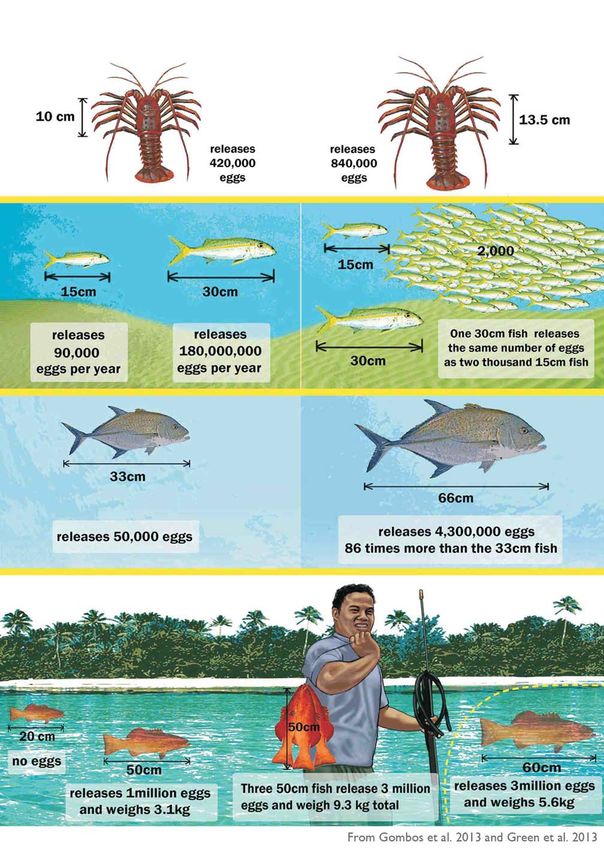
Ensure NTZs are large enough to contain all habitats used by focal species throughout their
              life history; or establish networks of NTZs close enough to allow for movements of focal
              species among protected habitats...................................................................................................................... 40
              Include whole ecological units in NTZs. If not, choose larger rather than smaller areas..................................... 42
              Use compact shapes for NTZs, except when protecting naturally elongated habitats......................................... 42
     C o n s i d e r Larval D i s p e rs al . . . . . . . . . . . . . . . . . . . . . . . . . . . . . . . . . . . . . . . . . . . . . . . . . . . . . . . . . . . . . . . . . . . . . . . . . . . . . . . . . . . . . . . . . . . . . . . . . . . . . . . . . . . . . . . . . . . . . . . . . . . . . . . . . . . . . 42

      Establish: NTZs large enough to be self-sustaining for focal species, or networks of NTZs
      close enough to be connected by larval dispersal................................................................................................ 45
      Protect spatially isolated areas in NTZs............................................................................................................. 46
      Protect larval sources in permanent or seasonal NTZs or by using fisheries closures during
      spawning times.................................................................................................................................................. 46
      Locate more NTZs upstream relative to fished areas if there is a strong, consistent,
      unidirectional current.......................................................................................................................................... 46
Allow Time for Recovery                                                  . . . . . . . . . . . . . . . . . . . . . . . . . . . . . . . . . . . . . . . . . . . . . . . . . . . . . . . . . . . . . . . . . . . . . . . . . . . . . . . . . . . . . . . . . . . . . . . . . . . . . . . . . . . . . . . . . . . . . . . . . . . . . . . . . . . . . . . . . . . 48

      Establish NTZs for the long term (more than 20 up to 40 years), preferably permanently................................ 48
      Use short-term (less than 5 years) or periodically harvested NTZs in addition to, rather
      than instead of, long-term or permanent NTZs.................................................................................................. 48
Protect Healthy Areas and Avoid Local Threats                                                                                                  ....................................................................................................... 50

      Protect areas where habitats and populations of focal species are in good condition with
      low levels of threat............................................................................................................................................. 50
      Avoid areas where habitats and populations of focal species are in poor condition due
      to local threats. If this is not possible, reduce threats, facilitate natural recovery, and consider
      the costs and benefits of rehabilitating habitats and species.............................................................................. 50
Adapt to Changes in Climate and Ocean Chemistry                                                                                                                  .............................................................................................. 52

      Protect sites that are likely to be more resilient to global environmental change (refugia)
      in NTZs.............................................................................................................................................................. 54
      Protect ecologically important sites that are sensitive to changes in climate and ocean
      chemistry............................................................................................................................................................ 54
      Increase protection of species that play important functional roles in ecosystem resilience................................ 55
      Consider how changes in climate and ocean chemistry will affect the life history of focal
      species............................................................................................................................................................... 55
      Address uncertainty by spreading the risk, and increasing protection of habitats, critical areas
      and species most vulnerable to changes in climate and ocean chemistry............................................................56
DISCUSSION                          .............................................................................................................................................................. 57

Integrating Biophysical, Socioeconomic and Cultural Design Criteria                                                                                                                                                  ................................................................... 58

Integrating MPAs within Broader Management Frameworks                                                                                                                                    .................................................................................. 58

Research Priorities                                 ..................................................................................................................................................... 59

SUMMARY                    . . . . . . . . . . . . . . . . . . . . . . . . . . . . . . . . . . . . . . . . . . . . . . . . . . . . . . . . . . . . . . . . . . . . . . . . . . . . . . . . . . . . . . . . . . . . . . . . . . . . . . . . . . . . . . . . . . . . . . . . . . . . . . . . . . . . . . . . . . . . . . . . . . . . . . . . . . . . . . . . . . . 60

APPENDIX 1 . Habitat Classification                                                                        . . . . . . . . . . . . . . . . . . . . . . . . . . . . . . . . . . . . . . . . . . . . . . . . . . . . . . . . . . . . . . . . . . . . . . . . . . . . . . . . . . . . . . . . . . . . . . . . . . . . . . . . . . . . . . . . . . . . . . . . . 67

APPENDIX 2. Abiotic Factors                                                            . . . . . . . . . . . . . . . . . . . . . . . . . . . . . . . . . . . . . . . . . . . . . . . . . . . . . . . . . . . . . . . . . . . . . . . . . . . . . . . . . . . . . . . . . . . . . . . . . . . . . . . . . . . . . . . . . . . . . . . . . . . . . . . . . . . 70

APPENDIX 3. Rehabilitating Habitats and Species                                                                                                         . . . . . . . . . . . . . . . . . . . . . . . . . . . . . . . . . . . . . . . . . . . . . . . . . . . . . . . . . . . . . . . . . . . . . . . . . . . . . . . . . . . . . . . . . . . . . . . . . . . 71

REFERENCES                          . . . . . . . . . . . . . . . . . . . . . . . . . . . . . . . . . . . . . . . . . . . . . . . . . . . . . . . . . . . . . . . . . . . . . . . . . . . . . . . . . . . . . . . . . . . . . . . . . . . . . . . . . . . . . . . . . . . . . . . . . . . . . . . . . . . . . . . . . . . . . . . . . . . . . . . . . . . . . . 73

4                BIOPHYSICAL CRITERIA: DESIGNING MPAs AND MPA NETWORKS TO BENEFIT PEOPLE AND NATURE
                 IN INDONESIA
LISTS OF FIGURES AND TABLES
Figures
Figure 1 . Indonesia has several shallow shelves and deep-sea basins, comprising 1 2 marine ecoregions.............. 1 6
Figure 2. Indonesia comprises some of the highest marine diversity on Earth........................................................ 1 6
Figure 3. More than 35% of coral reefs in Indonesia are at high or very high risk from local threats..................... 1 9
Figure 4. Different species use different habitats....................................................................................................... 26
Figure 5. Protecting at least three examples of each major habitat in widely separated MPAs helps
reduce the chances they will all be impacted by the same disturbance....................................................................28
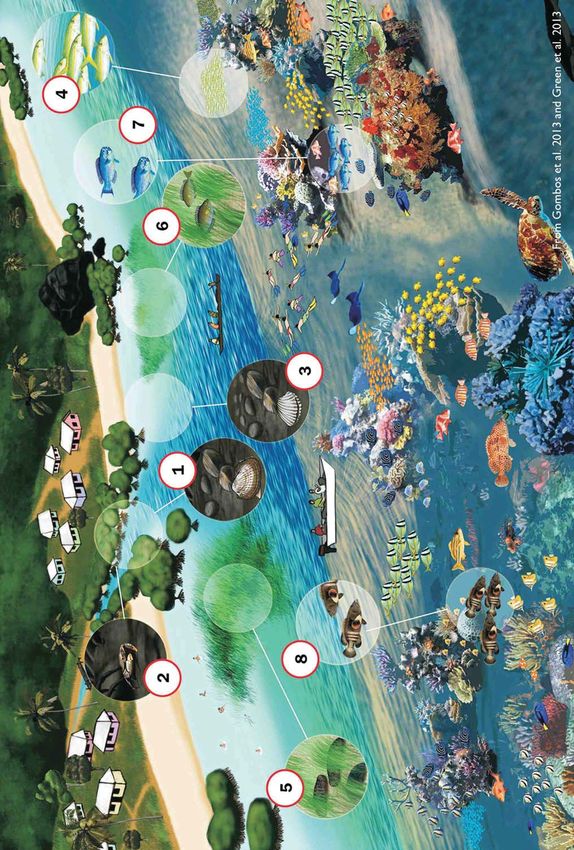
Figure 6. Some species use different habitats at different times throughout their lives (e.g., for home
ranges, spawning or nursery areas)............................................................................................................................30
Figure 7. Olive ridley sea turtles nesting in West Papua and green sea turtles nesting in East
Kalimantan travel to feeding areas in other Indonesian provinces or countries in Southeast Asia......................... 32
Figure 8. A larval dispersal model shows how coral trout (Plectropomus leopardus) populations are
shared among Indonesia and other countries in the Coral Triangle......................................................................... 35
Figure 9. Major ocean currents in Indonesia include the Indonesia Throughflow and the
Halmahera and Mindanao Eddies. Surface currents in eastern Indonesia reverse direction twice a year.............. 36
Figure 1 0. Most coral reef fishes (such as the coral trout P. leopardus) have two life history phases.
Adults and juveniles are benthic and live on coral reefs, while larvae are pelagic and live in the plankton............ 37
Figure 1 1 . Larger individuals are more important for long-term health of populations than smaller ones,
because they produce a lot more offspring............................................................................................................... 39
Figure 1 2. Different species have home ranges of different sizes............................................................................. 41
Figure 1 3. Where possible, whole ecological units (e.g., reefs) should be included in NTZs, and
the NTZs should be compact shapes (e.g., squares), except when protecting naturally elongated
habitats (e.g., fringing reefs)........................................................................................................................................ 43
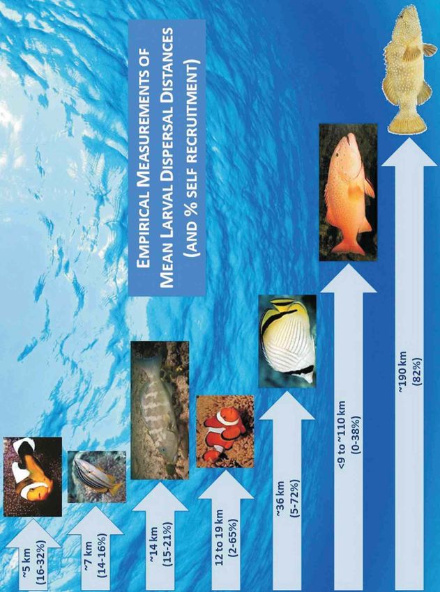
Figure 1 4. Different coral reef fish species have different larval dispersal distances................................................47
Figure 1 5. Some species are more vulnerable to fishing pressure and take longer to recover when
protected in NTZs...................................................................................................................................................... 49
Figure 1 6. Healthy marine ecosystems provide abundant resources for people. Unhealthy
ecosystems, damaged by local threats, are unable to provide as many resources for people................................ 51
Figure 1 7. Some areas may be more resilient to changes in climate and ocean chemistry (refugia) and
should be protected in NTZs ....................................................................................................................................53
Figure 1 8. Coral reef seascapes in Raja Ampat. Different colors show different types of coral reef
communities, which should each be protected in NTZs.......................................................................................... 68
Tables
Table 1 . Biophysical criteria for designing MPAs and MPA Networks in Indonesia................................................. 1 0
Table 1 . Kriteria biofisik untuk merankang KKP dan jaringan KKP di Indonesia.......................................................1 2
Table 2. Research priorities for applying biophysical criteria to design MPAs and MPA Networks in
Indonesia......................................................................................................................................................................59
Table 3. Summary of scientific rationale (and explanatory notes) for biophysical criteria for designing
MPAs and MPA Networks in Indonesia..................................................................................................................... 61
5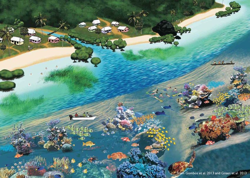
FOREWORD
Indonesia is located in the heart of the Coral Triangle, a region that contains high marine coastal biodiversity,
including the second-largest coral reef area in the world and diverse mangrove ecosystems. The Government of
Indonesia thus recognizes the need, and really wants to step up, to apply proven methods and approaches to
manage and conserve our country’s rich marine diversity for the benefit of the Indonesian people and economy,
and the sustainability of its marine heritage and environment. This work underpins our national conservation
commitments related to the Convention on Biological Diversity (CBD) and the Coral Triangle Initiative on Coral
Reefs, Fisheries and Food Security (CTI-CFF).
Since the Coral Triangle countries formed the CTI-CFF in 2009, addressing multiple issues and objectives to
effectively sustain marine and coastal resources has become of paramount importance for our government One
of the primary strategies being used almost everywhere to serve the needs of marine conservation and marine
resource and fisheries management is the design and implementation of MPA Networks. However, MPA
Networks will not be effective unless they can combine the multiple objectives important to stakeholders,
including fisheries, tourism and other economic and social benefits that result from effective MPAs and their
Networks. For this reason the Ministry of Marine Affairs and Fisheries is initiating the development of MPA
Networks in several priority main regions in Indonesia, namely, West Sumatra, Riau Islands, Nusa Tenggara (East
and West), and West Papua.
The USAID Sustainable Ecosystems Advanced Project (USAID SEA), together with the Directorate for Marine
Conservation and Biodiversity of the Directorate General for Marine Spatial Management in the Ministry of
Marine Affairs and Fisheries, has developed this document, Biophysical Criteria: Designing Marine Protected Areas
and Marine Protected Area Networks to Benefit People and Nature in Indonesia, to guide the identification, design and
evaluation MPA Networks in Indonesia. This document can help MPA managers in Indonesia to determine critical
MPA and MPA Network design inputs, and thus support the implementation of existing national regulations on
MPA Networks. It also provides an integrated set of biophysical criteria to help practitioners design MPA
Networks to achieve fisheries sustainability, biodiversity conservation, and ecosystem resilience in the face of
climate change in Indonesia.
This document is tailored to the Indonesian marine environment, providing a succinct, graphic and user-friendly
synthesis of the best available scientific information for practitioners who may not have access to, or the time to
review, the increasing amount of research literature on this topic. It will serve as an excellent reference for our
ongoing work in Indonesia on MPA Network design.
We fully endorse this technical guide and encourage all MPA planners and practitioners to make good use of it as
a reference in improving our Indonesian MPA Network design and implementation

Andi Rusandi
Director for Marine Conservation and Biodiversity
Directorate General for Marine Spatial Management
Ministry of Marine Affairs and Fisheries

6       BIOPHYSICAL CRITERIA: DESIGNING MPAs AND MPA NETWORKS TO BENEFIT PEOPLE AND NATURE
        IN INDONESIA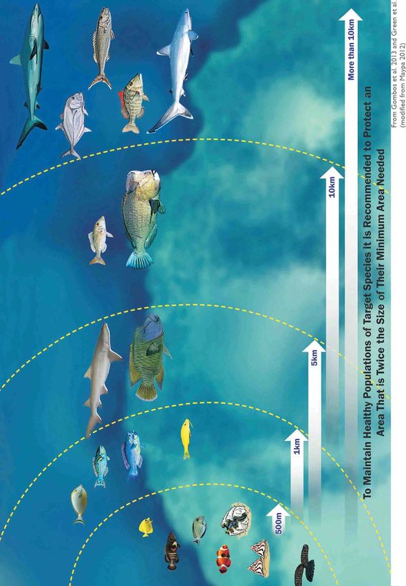
PREFACE
The aim of this document is to provide the scientific rationale for the biophysical criteria required to design
marine protected areas (MPAs) and MPA Networks to achieve their biophysical goals and contribute toward
achieving their socioeconomic and cultural goals in Indonesia. The document provides a synthesis of the best
available scientific information for MPA practitioners who may not have access to, or the time to review, the
extensive literature on this issue. It also provides examples and case studies of best practices for applying these
design criteria in Indonesia and elsewhere.
This document supports the biophysical design criteria incorporated in the document A Guide, Framework and
Example: Designing Marine Protected Areas and Marine Protected Area Networks to Benefit People and Nature in
Indonesia (Green et al. 2020), which provides supplementary information to support the Technical Guidelines
(Juknis) of Ministerial Regulation No. 1 3/201 4 on Establishing and Managing MPA Networks. It also complements the
supplementary information on socioeconomic and cultural design criteria in the said guidance document.
This document is a detailed guide intended for senior technical staff in the Ministry of Marine Affairs and Fisheries,
staff in the Ministry of Forestry and Environment (marine units), universities, non-governmental organizations and
others interested to learn how to plan for effective marine conservation through MPAs and MPA networks. It
provides a succinct, graphic and user-friendly synthesis of scientific information based on previous work produced
for the Coral Triangle Initiative on Coral Reefs, Fisheries and Food Security (CTI-CFF) through the USAID Coral
Triangle Support Partnership, particularly the report Designing Marine Protected Area Networks to Achieve Fisheries,
Biodiversity and Climate Change Objectives in Tropical Ecosystems: A Practitioner's Guide (Green et al. 201 3) and
associated scientific publications (e.g., Abesamis et al. 201 4, Green et al. 201 4a, 201 5: available at
http://nature.org/MPANetworkDesign).
CTI-CFF is a multilateral partnership of six countries working together to address urgent threats to one of the
world's most biologically diverse and ecologically rich regions: the Coral Triangle. Recognizing the need for
concerted action at the regional scale for marine conservation and resource management, the six Coral Triangle
countries endorsed in 2009 a 1 0-year (201 0-2020) Regional Plan of Action (RPOA) that defines the establishment
and effective management of MPAs as one of the primary goals. There is one target under this goal: A region-
wide Coral Triangle MPA System (CTMPAS) in place and fully functional. A first step toward achieving this target
is to scale up the initiatives of each of the national MPA network programs. This guide for Indonesia is fully in line
with the CTMPAS and will help the country move toward improved MPA Network design and contribute directly
to the system of MPAs for CTI-CFF.
The United States Agency for International Development Sustainable Ecosystems Advanced Project (USAID SEA)
is a five-year project (201 6-2021 ) that supports the Government of Indonesia to improve the governance of
fisheries and marine resources and to conserve biological diversity in Indonesia through fisheries management and
MPAs in target areas in Indonesia. We in USAID SEA are proud of our contribution to the improvement of MPAs
in Indonesia. We hope that this document will serve to build more and better MPA Networks in the country to
achieve fisheries management and biodiversity conservation, and to enhance the resilience of our coastal
resources amid climate change and local human pressures. We thank all those who contributed to this work and
look forward seeing the results in action.

Alan White
Chief of Party
USAID Sustainable Ecosystems Advanced Project

                                                                                                                    7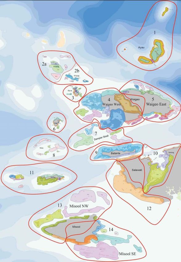
ACKNOWLEDGMENTS
This document was produced as part of the USAID Sustainable Ecosystems Advanced (SEA) Project that
supports the Government of Indonesia to improve the governance of fisheries and marine resources and
conserve biological diversity. The authors thank Andi Rusandi, Director for Marine Conservation and Biodiversity
of the Ministry of Marine Affairs and Fisheries (MMAF), and Firdaus Agung, MMAF Deputy Director for
Convention and Conservation, for leading this process, and USAID for supporting the project.
In 201 8 and 201 9, The Nature Conservancy and USAID SEA facilitated a series of 1 2 workshops at the national
and provincial level to develop the document A Guide, Framework and Example: Designing Marine Protected Areas
and Marine Protected Area Networks to Benefit People and Nature in Indonesia (Green et al. 2020), which includes
the biophysical design criteria described in this document. The authors thank the 234 participants from 69
institutions who contributed to these workshops, including experts and partners from government agencies
(national, provincial and district), universities, non-governmental organizations, and local communities (Green et
al. 2020).
We also thank others who have contributed to developing the information contained in this document,
particularly Dr. Maria Beger from the University of Leeds, for allowing us to use the results of her unpublished
model of larval dispersal in Figure 8. Finally, we acknowledge several key earlier publications that provided the
foundation for much of the material in this book which are referenced throughout the text as appropriate.

The Authors

8      BIOPHYSICAL CRITERIA: DESIGNING MPAs AND MPA NETWORKS TO BENEFIT PEOPLE AND NATURE
       IN INDONESIA
EXECUTIVE SUMMARY
Indonesia comprises some of the world’s most diverse tropical marine ecosystems, which are a global priority for
conservation. These rich marine resources provide important ecosystem goods and services, particularly for
coastal communities who rely on these resources for their food security and livelihoods. Unfortunately, these
critically important resources and the ecosystem services they provide are threatened by local anthropogenic
threats (e.g., destructive or overfishing, coastal development and runoff from poor land use practices) and global
changes in climate and ocean chemistry.
Marine Protected Areas (MPAs), particularly no-take zones (NTZs), can be powerful tools to address local
threats and enhance fisheries productivity, protect biodiversity and adapt to changes in climate and ocean
chemistry. They can also enhance food security and sustainable livelihoods for communities and other
stakeholders. MPA Networks can deliver additional benefits, such as by acting as mutually replenishing networks
to facilitate recovery after disturbance. However, MPAs and MPA Networks can only achieve these objectives if
they are well designed and effectively managed.
MPAs and MPA Networks play a major role in conservation and resource management in Indonesia, and the
national government is committed to establishing 20 million hectares (ha) of effectively managed MPAs by 2020
and 30 million ha by 2030. To date, there are 1 77 national and local government MPAs established (and no MPA
Networks), covering an area of 22.8 million ha. The Ministry of Marine Affairs and Fisheries (MMAF) is now
identifying and establishing new MPAs to achieve their target of 30 million ha in MPAs by 2030, and is interested in
reviewing the design of existing MPAs. Local communities have also established Locally Managed Marine Areas in
many locations, particularly in eastern Indonesia. Unfortunately, many of these MPAs are not yet managed
effectively. More scientific advice is required to ensure that MPAs and MPA Networks are well designed to
achieve their goals.
In 201 9, The Nature Conservancy and the USAID Sustainable Ecosystems Advanced Project (USAID SEA)
provided technical assistance to MMAF to develop the document A Guide, Framework and Example: Designing
Marine Protected Areas and Marine Protected Area Networks to Benefit People and Nature in Indonesia (Green et al.
2020). This document provides a logical framework (goals, objectives, design criteria and performance indicators)
for designing MPAs and MPA Networks, which takes biophysical, socioeconomic and cultural considerations into
account. This framework will provide supplementary information to support the MMAF’s Technical Guidelines
(Juknis) of Ministerial Regulation No. 1 3/201 4 on Establishing and Managing MPA Networks.
Indonesia has both biophysical goals and socioeconomic/cultural goals in establishing MPAs and MPA networks:
• Biophysical goals include protecting biodiversity, maintaining or enhancing coastal fisheries, rehabilitating
habitats and species, and adapting to changes in climate and ocean chemistry; and
• Socioeconomic and cultural goals include minimizing conflicting use of marine resources and fisheries,
supporting sustainable community livelihoods, and promoting active community participation and support
in MPA or MPA network management.
The aim of this document is to provide the scientific rationale for the biophysical criteria required to design MPAs
and MPA Networks to achieve these goals (Table 1 ). The document provides a synthesis of the best available
scientific information for MPA practitioners who may not have access to, or the time to review, the extensive
literature on this issue. It also provides examples and case studies of best practice for applying these design
criteria in Indonesia and elsewhere.
9These biophysical design criteria will contribute to a larger process that includes implementing MPA Networks in
ways that complement human uses and values, and align with local legal, political and institutional requirements.
To make sure this is the case, they should be used in conjunction with the socioeconomic and cultural design
criteria for Indonesia provided in the document A Guide, Framework and Example: Designing Marine Protected Areas
and Marine Protected Area Networks to Benefit People and Nature in Indonesia (Green et al. 2020).
Table 1 . Biophysical criteria for designing MPAs and MPA Networks in Indonesia
Please note that many of these criteria are designed to consider the ecology of focal species, including key fisheries species,
endangered, threatened and protected species, migratory marine biota, large charismatic marine fauna, and species important for
maintaining ecosystem function.
Biophysical Criteria for Designing MPAs and MPA Networks in Indonesia
Represent Habitats
Protect at least 20% of each major habitat in NTZs.
Replicate Habitats (Spread the Risk)
Protect at least three examples of each major habitat in NTZs; and
Spread them out to reduce the chances they will all be affected by the same disturbance.
Protect Critical, Special and Unique Areas
Protect critical areas in the life history of focal fisheries species in NTZs.
Protect critical areas or habitats for charismatic, endangered, threatened or protected species.
Protect special and unique natural phenomena in NTZs.
Protect areas that are important at the national, international or global scale for conservation or management of focal species.
Incorporate Connectivity:Abiotic Factors
Consider variations in oceanography that affect the spread of biological and non-biological material.
Incorporate Connectivity: Biotic Factors Movement of Adults and Juveniles
Ensure NTZs are large enough to sustain adults and juveniles of focal fisheries species within their boundaries.
Ensure NTZs are large enough to contain all habitats used by focal species throughout their life history; or establish networks of
NTZs close enough to allow for movements of focal species among protected habitats.
Include whole ecological units in NTZs. If not, choose larger rather than smaller areas.
Use compact shapes for NTZs, except when protecting naturally elongated habitats.
Incorporate Connectivity: Biotic Factors Larval Dispersal
Establish NTZs large enough to be self-sustaining for focal species; or networks of NTZs close enough to be connected by larval
dispersal.
Protect spatially isolated areas in NTZs.
Protect larval sources in permanent or seasonal NTZs or by using fisheries closures during spawning times.
Locate more NTZs upstream relative to fished areas if there is a strong, consistent, unidirectional current.
AllowTime for Recovery
Establish NTZs for the long term (more than 20 up to 40 years), preferably permanently.
Use short-term (less than 5 years) or periodically harvested NTZs in addition to, rather than instead of, long-term or permanent
NTZs.
Protect Healthy Areas and Avoid LocalThreats
Protect areas where habitats and populations of focal species are in good condition with low levels of local threats.
Avoid areas where habitats and populations of focal species are in poor condition due to local threats. If this is not possible:
reduce threats; facilitate natural recovery; and consider the costs and benefits of rehabilitating habitats and species.
Adapt to Changes in Climate and Ocean Chemistry
Protect sites that are likely to be more resilient to global environmental change (refugia) in NTZs.
Protect ecologically important sites that are sensitive to changes in climate and ocean chemistry.
Increase protection of species that play important functional roles in ecosystem resilience.
Consider how changes in climate and ocean chemistry will affect the life history of focal species.
Address uncertainty by: spreading the risk; and increasing protection of habitats, critical areas and species most vulnerable to
changes in climate and ocean chemistry.
10 BIOPHYSICAL CRITERIA: DESIGNING MPAs AND MPA NETWORKS TO BENEFIT PEOPLE AND NATURE
IN INDONESIARINGKASAN EKSEKUTIF
Indonesia mempunyai beberapa ekosistem laut tropis paling beragam di dunia, yang merupakan prioritas global
untuk konservasi. Sumber daya laut yang melimpah ini menyediakan produk dan jasa ekosistem yang penting,
terutama bagi masyarakat pesisir yang menggantungkan hidupnya pada sumber daya ini untuk ketahanan pangan
dan mata pencaharian mereka. Sayangnya, banyak dari sumber daya yang sangat penting ini dan jasa ekosistem
yang mereka berikan telah hilang, terdegradasi serius atau terancam oleh kombinasi ancaman antropogenik lokal
(yaitu aktivitas penangkapan ikan yang merusak atau berlebih, pariwisata masal, pengembangan pesisir dan limbah
dari daratan), ancaman perubahan iklim dan perubahan kimia laut global.
Kawasan Konservasi Perairan (KKP), terutama zona larang tangkap (ZLT), dapat menjadi cara yang ampuh untuk
menangani ancaman-ancaman lokal, meningkatkan produktivitas perikanan, melindungi keanekaragaman hayati,
dan meningkatkan ketahanan terhadap perubahan iklim dan kimia laut global. KKP juga dapat meningkatkan
ketahanan pangan dan mata pencaharian berkelanjutan bagi masyarakat dan pemangku kepentingan lainnya.
Dengan dibentuknya jejaring KKP1 dapat memberikan manfaat tambahan (misalnya dengan bertindak sebagai
jaringan yang saling mendukung pada saat pemulihan setelah gangguan). Namun, KKP dan jejaring KKP hanya dapat
mencapai tujuan tersebut jika dirancang dengan baik dan dikelola secara efektif.
KKP dan jaringan KKP2 memainkan peran penting dalam konservasi dan pengelolaan sumber daya laut di
Indonesia. Pemerintah Indonesia berkomitmen untuk menetapkan 20 juta hektar KKP yang dikelola secara efektif
pada 2020 dan 30 juta hektar pada 2030. Hingga saat ini, terdapat 1 77 KKP yang dikelola Pemerintah Pusat dan
Daerah di Indonesia (tanpa jejaring KKP) (Gambar 1 ), dengan total luas 22.786.1 83 hektar. Kementerian Kelautan
dan Perikanan saat ini sedang dalam proses mengidentifikasi dan menginisiasi KKP baru untuk mencapai target 30
juta hektar pada tahun 2030, dan tertarik untuk meninjau desain KKP yang telah ada. Masyarakat lokal juga telah
mendirikan Daerah Perlindungan Laut (DPL) yang dikelola secara lokal di banyak lokasi, khususnya di Indonesia
bagian timur.
Sayangnya, banyak KKP di Indonesia belum dikelola secara efektif. Saran ilmiah diperlukan untuk memastikan
bahwa KKP dan jaringan KKP dirancang dengan baik untuk mencapai tujuan dan sasaran mereka.
Baru-baru ini, The Nature Conservancy melalui Proyek USAID Sustainable Ecosystems Advanced (SEA)
memberikan bantuan teknis kepada Kementerian Kelautan dan Perikanan untuk menyusun dokumen Merancang
Kawasan Konservasi Perairan dan Jaringan Kawasan Konservasi Perairan: Panduan, Kerangka Kerja dan Contoh untuk
Indonesia. Dokumen ini memberikan kerangka kerja logis (tujuan, sasaran, kriteria desain, dan indikator kinerja)
untuk merancang KKP dan jaringan KKP, yang mempertimbangkan aspek biofisik, sosial ekonomi, dan budaya.
Kerangka kerja ini akan memberikan informasi tambahan untuk mendukung dokumen Petunjuk Teknis Peraturan
Menteri No. 1 3/201 4 tentang Pembentukan dan Pengelolaan Jejaring KKP.
Indonesia memiliki banyak tujuan untuk membentuk KKP dan jaringan KKP yakni:
• Tujuan biofisik, antara lain untuk melindungi keanekaragaman hayati, mempertahankan atau meningkatkan
perikanan pesisir, merehabilitasi habitat dan spesies, dan beradaptasi dengan perubahan iklim dan kimia laut;
dan
• Tujuan sosial ekonomi dan budaya, antara lain untuk meminimalkan konflik pemanfaatan sumber daya laut
dan perikanan, mendukung mata pencaharian masyarakat yang berkelanjutan, dan mendorong partisipasi
dan dukungan aktif masyarakat dalam pengelolaan KKP dan Jejaring KKP.
___________________________________
1 Jejaring KKP: kerja sama pengelolaan dua atau lebih KKP secara sinergis yang memiliki keterkaitan biofisik atau sosial ekonomi dan
budaya
2 Jaringan KKP: hubungan antara beberapa KKP secara biofisik atau sosial ekonomi dan kultur
11Tujuan dari dokumen ini adalah untuk memberikan dasar pemikiran ilmiah untuk kriteria rancangan biofisik yang
diperlukan untuk merancang KKP dan Jaringan KKP untuk mencapai tujuan-tujuan tersebut (Tabel 1 ). Dokumen
ini merupakan sintesis informasi ilmiah terbaik yang tersedia untuk praktisi KKP yang mungkin tidak memiliki akses,
atau waktu untuk meninjau, literatur yang banyak tentang topik ini. Dokumen ini juga memberikan contoh dan
studi kasus praktik terbaik untuk menerapkan kriteria rancangan ini di Indonesia dan di tempat lain.
Kriteria rancangan biofisik ini akan berkontribusi pada proses yang lebih kompleks, yang mencakup penerapan
jaringan KKP dengan memperhatikan pemanfaatan dan nilai-nilai manusia, sejalan dengan persyaratan hukum,
politik dan kelembagaan lokal. Untuk memastikan hal ini terjadi, kriteria rancangan biofisik harus digunakan
bersama-sama dengan kriteria rancangan sosial ekonomi dan budaya untuk Indonesia yang disediakan dalam
dokumen Merancang Kawasan Konservasi Perairan dan Jaringan Kawasan Konservasi Perairan: Panduan, Kerangka Kerja
dan Contoh untuk Indonesia.
Table 1 . Kriteria biofisik untuk merancang KKP dan Jaringan KKP di Indonesia.
Sebagai catatan bahwa sebagian dari kriteria ini dirancang untuk mempertimbangkan aspek ekologi spesies penting termasuk
spesies perikanan penting, langka, terancam, dan dilindungi, biota laut yang bermigrasi, biota laut kharismatik besar, dan biota yang
penting untuk menjaga fungsi ekosistem.
Kriteria biofisik untuk merancang KKP dan Jaringan KKP di Indonesia
Mewakili Habitat
Melindungi setidaknya 20% dari setiap habitat utama di dalam ZLT.
Mereplikasi Habitat (Menyebarkan Resiko)
Melindungi setidaknya tiga contoh dari masing-masing jenis habitat utama di dalam ZLT; dan
Menyebarkan habitat-habitat utama tersebut untuk mengurangi kemungkinan dipengaruhi oleh gangguan yang sama.
Melindungi Area Penting, Khusus, dan Unik
Melindungi area-area penting dalam sejarah hidup spesies penting di dalam ZLT.
Melindungi area-area atau habitat penting untuk spesies yang kharismatik, langka, terancam, atau dilindungi.
Melindungi fenomena alam khusus dan unik di dalam ZLT.
Melindungi area-area yang penting di skala nasional, internasional, dan global untuk konservasi atau pengelolaan spesies penting.
Memasukkan Aspek Konektivitas: Faktor-faktor Abiotik
Mempertimbangkan variasi osenografi yang mempengaruhi penyebaran materi biologis dan non-biologis di laut.
Memasukkan Aspek Konektivitas: Faktor-faktor Biotik Pergerakan Dewasa dan Anakan
Memastikan ZLT cukup besar untuk menopang spesies perikanan yang penting dalam batasan ruang hidupnya selama fase
kehidupan dewasa dan anakan.
Memastikan ZLT cukup besar untuk menampung semua habitat yang digunakan oleh spesies penting selama sejarah hidupnya;
atau menetapkan jejaring ZLT yang cukup dekat untuk memungkinkan pergerakan spesies penting di antara habitat-habitat
yang dilindungi.
Memasukkan keseluruhan unit-unit ekologi di dalam ZLT. Bila tidak, pilih area yang lebih besar dibandingkan dengan yang lebih
kecil.
Menggunakan bentuk-bentuk sederhana untuk ZLT, kecuali saat melindungi habitat memanjang yang alami.
Memasukkan Aspek Konektivitas: Faktor-faktor Biotik Penyebaran Larval
Menetapkan ZLT cukup besar agar dapat mandiri menampung spesies penting; atau jaringan ZLT terhubung cukup dekat oleh
penyebaran larva.
Melindungi daerah yang terisolasi secara spasial di dalam ZLT.
Melindungi sumber larva dalam ZLT yang permanen atau musiman atau dengan penutupan perikanan sementara selama periode
pemijahan.
Menempatkan ZLT lebih ke hulu arah arus relatif dari area penangkapan ikan jika ada arus yang kuat, konsisten, dan searah.
Memberikan Waktu untuk Pemulihan
Menetapkan ZLT untuk jangka panjang (20-40 tahun), sebaiknya permanen.
Menggunakan ZLT jangka pendek (< 5 tahun) atau yang bisa dipanen secara berkala sebagai tambahan untuk ZLT yang
berjangka panjang atau permanen.
12 BIOPHYSICAL CRITERIA: DESIGNING MPAs AND MPA NETWORKS TO BENEFIT PEOPLE AND NATURE
IN INDONESIAKriteria biofisik untuk merancang KKP dan Jaringan KKP di Indonesia
Melindungi Area yang Sehat dan Menghindari Ancaman Lokal
Melindungi daerah-daerah dimana habitat dan populasi dari spesies penting dalam kondisi baik dengan tingkat ancaman yang
rendah.
Menghindari daerah-daerah dimana habitat dan populasi dari spesies penting dalam kondisi buruk karena ancaman lokal. Bila
tidak dimungkinkan: mengurangi ancaman; memfasilitasi pemulihan secara alami; dan mempertimbangkan biaya dan manfaat
dari merehabilitasi habitat dan spesies.
Adaptasi terhadap Perubahan Iklim dan Kimia Laut
Melindungi lokasi yang cenderung lebih tangguh terhadap perubahan lingkungan global di dalam ZLT.
Melindungi lokasi penting untuk ekologi yang sensitif terhadap perubahan iklim dan kimia laut di dalam zona larang tangkap.
Meningkatkan perlindungan spesies yang memiliki fungsi peranan penting bagi ketahanan ekosistem.
Mempertimbangkan bagaimana perubahan iklim dan kimia laut akan mempengaruhi sejarah hidup spesies penting.
Menangani ketidakpastaian dengan: menyebarkan resiko; dan meningkatkan perlindungan habitat, daerah penting, dan spesies
yang paling rentan terhadap perubahan iklim dan kimia laut.
13INTRODUCTION
Tropical Marine Ecosystems in Indonesia
Indonesia is the largest archipelagic country in the world, spanning 5,1 20 km from east to
west and comprising nearly 1 8,1 00 islands, 1 08,820 km of coastline and 5.8 million square
kilometres (km 2) of water3 (Asian Development Bank [ADB] 201 4).
The archipelago lies between the Pacific and Indian Oceans and is divided into several shallow
shelves and deepsea basins (ADB 201 4), as shown in Figure 1 . These waters comprise a wide
variety of marine ecosystems of high value for conservation and management, including both
shallow-water habitats 4 less than 200 meters (m) deep, such as coral reefs, mangroves and
seagrass beds, and deepwater benthic and pelagic habitats at least 200m deep, including
seamounts and persistent pelagic features.
As shown in Figure 1 , Indonesia comprises 1 2 marine ecoregions, areas of relatively
homogeneous species composition clearly distinct from adjacent systems (Spalding et al.
2007). Species composition in each ecoregion is likely determined by the ecosystems present
and/or a distinct suite of oceanographic or topographic features. The dominant
biogeographic forcing agents defining the ecoregions vary from location to location but may
include upwelling, nutrient inputs, freshwater influx, temperature regimes, exposure,
sediments, currents, isolation, and bathymetric or coastal complexity.
____________________________
3 2.8 million km 2 of archipelagic waters, 0.3 million km 2 of territorial sea, and 2.7 million km 2 of exclusive
economic zone (ADB 201 4).
4 The 200 m depth contour is often used as a proxy for the edge of the continental shelf where there is a
dramatic ecotone between shallow and deepwater habitats (Spalding et al. 2007).
15From Spalding et al. 2007,
redrawn by Huffard et al. 201 2
Figure 1 . Indonesia has several shallow shelves and deep-sea basins, comprising 1 2 marine ecoregions.
Indonesia has one of the largest coral reef areas in the world, and the largest in Southeast Asia at 39,500 km 2,
which is 1 6% of the world’s reefs (Burke et al. 201 2). Indonesia’s coral reefs are also among the most biologically
diverse in the world (Figure 2), particularly in eastern Indonesia, which is the heart of the Coral Triangle and a
global priority for conservation (Allen & Erdmann 201 2, Veron et al. 201 5).
Global Diversity of Scleractinian (Hard) Corals (from Veron et al. 201 5)
Number of Species
Global Diversity of Mangroves (from Spalding et al. 201 0)
Number of Species
Figure 2. Indonesia comprises some of the highest marine diversity on Earth.
16 BIOPHYSICAL CRITERIA: DESIGNING MPAs AND MPA NETWORKS TO BENEFIT PEOPLE AND NATURE
IN INDONESIAIndonesia is also the center of global diversity for mangroves (Figure 2) and seagrasses, and hosts one-fifth of the
world’s mangrove forests and extensive seagrass ecosystems (Burke et al. 201 2, Spalding et al. 201 0). Indonesia’s
mangrove forests comprise 45 species occupying about 3.2 million hectares (ha), mostly in West Papua,
Kalimantan and Sumatra (Spalding et al. 201 0, ADB 201 4). Mangrove forests are productive ecosystems that
provide habitat for hundreds of species, support commercially important coastal finfish and shrimp fisheries,
export energy and organic matter to adjacent systems, and act as physical barriers against storm waves (Spalding
et al. 201 0, ADB 201 4).
Indonesia’s seagrass beds comprise 1 3 species spread over at least 30,000 km 2 in four main habitat types 5 (Short
et al 2007, ADB 201 4). Little is known about the distribution and current condition of seagrasses in Indonesia,
although the most expansive seagrass beds are found in the Arafura Sea, Papua, Sunda Shelf/Java Sea and Lesser
Sundas (Huffard et al. 201 2). Seagrass beds provide critical habitats for many commercially important species of
fish, shrimp and shellfish, and play important roles in fisheries production (Short et al. 2007). They also play
important roles in sediment accumulation and stabilization, filtering sediments from land-based runoff, serving as
daytime refugia for corals from ocean acidification, and providing critical habitat for endangered, threatened or
protected species (Short et al. 2007, Roberts et al. 201 7). Coastal wetlands (including mangroves and seagrasses)
also play a critical role in climate change mitigation through carbon sequestration and storage (Roberts et al.
201 7).
Mangroves and seagrass beds provide critical habitats for many species, and important food and livelihoods for coastal
communities. Images (left to right): South Sorong (© Alison Green, TNC) and East Sumba (Yusuf Fajariyanto, TNC).
Indonesia also has significant deepwater benthic and pelagic habitats. The pelagic environment is characterized by
physical processes that are highly dynamic in both space and time (e.g., ocean currents, thermal fronts, upwelling
and eddies), which largely control the abundance, distribution and composition of biological life (Game et al.
2009). Many pelagic species are also highly mobile, often covering thousands of kilometers (Green et al. 201 5).
Consequently, pelagic ecosystems are defined by the physical, chemical and biological features of the water
column (Game et al. 2009).
Indonesia has many deepwater bathymetric features, such as seamounts, canyons, ridges, trenches and sills
(Wilson et al. 201 1 ). In some locations, the seafloor drops to thousands-meter ocean depths close to shore, so
deep-sea features like seamounts and canyons occur within kilometers of the coast, e.g., in the Lesser Sunda
Ecoregion (Wilson et al. 201 1 ). These deepwater bathymetric features influence physical processes, generating
persistent pelagic habitats, such as areas with elevated productivity from consistent seasonal upwelling driven by
wind patterns and steep bathymetry close to shore (Game et al. 2009, Wilson et al. 201 1 ). These ‘deep-sea yet
nearshore’ habitats provide important feeding grounds and migratory pathways for commercially important
____________________________
5 Estuarine, shallow coastal, reef flats and deepwater, mostly found in waters less than 1 0m deep (Short et al 2007, Mangubhai et al.
201 2).
17pelagic fishes and large marine fauna such as cetaceans (whales and dolphins), turtles, sharks, manta rays and Mola
mola (Wilson et al. 201 1 , Huffard et al. 201 2).
Indonesia also provides other critically important feeding and breeding habitats for endangered, threatened or
protected species, including at least 22 cetacean species, dugong (Dugong dugon) and 6 species of sea turtle
(reviewed in Huffard et al. 201 2, ADB 201 4).
Ecosystem Goods and Services
More than 300 ethnic groups comprise Indonesia’s population of about 238 million (BPS 201 4), each with their
own culture and beliefs (ADB 201 4). Fifty-seven percent of the population lives on Java (7% of the land area),
while only 2% lives in the eastern Indonesian provinces of Maluku, North Maluku, Papua and West Papua, which
occupy 24% of the land area (Badan Pusat Statistik [BPS] 201 0, ADB 201 4). Their health, nutrition, food security,
economic growth, and welfare all depend upon the sustainable use of marine resources.
Indonesia’s rich marine resources generate important economic and social benefits from capture fisheries
(commercial and subsistence) and aquaculture, tourism, minerals, oil and gas, transport and shipping (Mangubhai
et al. 201 2, ADB 201 4). Coral reef, mangrove and seagrass ecosystems provide critical habitats for many
commercially valuable fisheries species, and are important sources of food and livelihoods for coastal
communities 6 (reviewed in Spalding et al. 201 0, ADB 201 4). The physical structure of coral reefs and mangroves
is vital for shoreline protection, as it dissipates wave energy, stabilizes shorelines, reduces erosion, and lessens
inundation and wave damage during storms, thus protecting human settlements, infrastructure and other habitats
like seagrasses (Burke et al. 201 2, Roberts et al. 201 7). Intact reefs and coastal wetlands can also help safeguard
people and infrastructure from the adverse effects of rising sea levels (Roberts et al. 201 7).
Coral reefs provide important ecosystem goods and services for people, including from tourism and fisheries. Images, left to
right: Raja Ampat Islands MPA (© Jeff Yonover) and Wakatobi National Park (Bridget Besaw).
Indonesia’s fisheries play an important role in national food security, since fishery products are generally
consumed by poor households (Food and Agriculture Organization [FAO] 2009). Indonesia has the highest total
fish and seafood consumption of any country in Southeast Asia, and the fifth highest in the world (FAO 201 0 in
Burke et al. 201 2). About 70% of the county’s protein sources come from fish, and in some poor coastal
communities, this figure approaches 90% (Huffard et al. 201 2).
Twenty-one percent of Indonesia’s agricultural economy and 3% of the country’s Gross Domestic Product (GDP)
are from the fishing industry (FAO 201 1 a). In 201 7, GDP from marine capture fisheries was valued at 1 4.8 billion
USD and the total national production was 23.3 million tons (BPS 201 4). More than one-third of the population
lives in coastal areas and depends on nearshore fisheries for their livelihood (ADB 201 4). About 95% of fishery
production is from artisanal fishers, with 28% of the marine fleet (620,830 vessels) using non-powered boats
(FAO 201 1 a). Women play a crucial role in fishing activities, although their involvement varies across ethnic
groups, cultures and religions, and with economic status (ADB 201 4).
____________________________
6 For fish farming and harvesting charcoal. firewood, construction materials, bed mattresses, handicrafts, animal feed, tannins and
medicines.
18 BIOPHYSICAL CRITERIA: DESIGNING MPAs AND MPA NETWORKS TO BENEFIT PEOPLE AND NATURE
IN INDONESIACoral reefs are particularly important sources of food and income for coastal communities in Indonesia (ADB
201 4). Nearly 60 million people live on the coast within 30 km of coral reefs, which is the largest reef-associated
human population of any country in the world, and more than one million fishers depend on coral reef fisheries
for their livelihoods (Burke et al. 201 2).
In 201 0, the annual net economic benefit in Indonesia from coral reef-related goods and services alone was
estimated to be approximately $2 billion USD, comprising $1 27 million from tourism, $1 .5 billion from fisheries
and $387 million from shoreline protection (reviewed in Burke et al. 201 2). Indonesia is among the top five
exporters of reef products globally, and marine tourism is growing rapidly and contributing more to the economy
at the local and national levels. Reefs are also valuable for research to develop potentially life-saving
pharmaceuticals, e.g., to treat cancer, HIV, and other diseases (Burke et al. 201 2).
However, Indonesia’s reefs face high levels of threats, and because people are highly dependent on reefs and have
a limited capacity to adapt to reef loss, the country is considered to have very high social and economic
vulnerability to coral reef degradation and loss (Burke et al. 201 2).
Status and Threats
H abitats
In Indonesia, many marine ecosystems and the services they provide have been lost or seriously degraded, or are
threatened by a combination of local anthropogenic threats including overharvesting, destructive fishing, coastal
development, mass tourism, watershed- and marine-based pollution, and mineral, oil and gas exploration and
mining (Burke et al. 201 2, ADB 201 4). Changes in climate and ocean chemistry also represent a serious and
increasing threat to these ecosystems, and the goods and services they provide (Burke et al. 201 2).
Heavy reliance on marine resources across Indonesia has led to marine resources being overexploited and
degraded, particularly those near major population centers (ADB 201 4). For example, nearly 95% of Indonesia’s
coral reefs are threatened by local human activities, with more than 35% at high or very high risk from overfishing,
destructive fishing, marine and watershed-based pollution and coastal development (Burke et al. 201 2) (Figure 3).
When the influence of thermal stress and coral bleaching is combined with local threats, the area of high- or very-
high-risk reefs increases to more than 45% (Burke et al. 201 2).
From Burke et al. 201 2
Figure 3. More than 35% of coral reefs in Indonesia are at high or very high risk from local threats.
19You can also read