Water sharing in the Upper Niger Basin - Altenburg & Wymenga
←
→
Page content transcription
If your browser does not render page correctly, please read the page content below
Water sharing in the Upper Niger Basin

                                 A&W-report 1739

               Commissioned by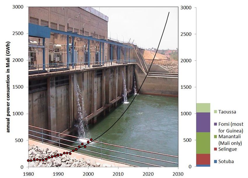
Water sharing in the Upper Niger Basin

A&W-report 1739

Eddy Wymenga
Leo Zwarts
Bakary Kone
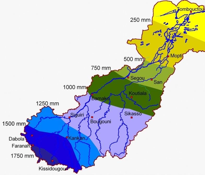
Photo Cover
Crossing the river ... and seeking new opportunities, Leo Zwarts

Eddy Wymenga, Leo Zwarts, Bakary Kone 2012
Water sharing in the Upper Niger Basin. A&W-rapport 1739.
Wetlands International, Bamako/Sévaré Mali & Altenburg & Wymenga ecological consultants, Feanwâlden
Netherlands.

Commissioned by
Wetlands International
P.O. box 471
6700 AL Wageningen
www.wetlands.org

Realised by
Altenburg & Wymenga ecological consultants
P.O. box 32
9269 ZR Feanwalden, The Netherlands
Telefoon 0511 47 47 64
Fax 0511 47 27 40
info@altwym.nl
www.altwym.nl

Project number                               Project leader                   Status
1839wwf                                      E. Wymenga                       Final report

Authorisation                                Autograph                        Date
Approved                                     W. Altenburg                     25 January 2012

©   Altenburg & Wymenga ecologisch onderzoek bv
    Overname van gegevens uit dit rapport is toegestaan met bronvermelding.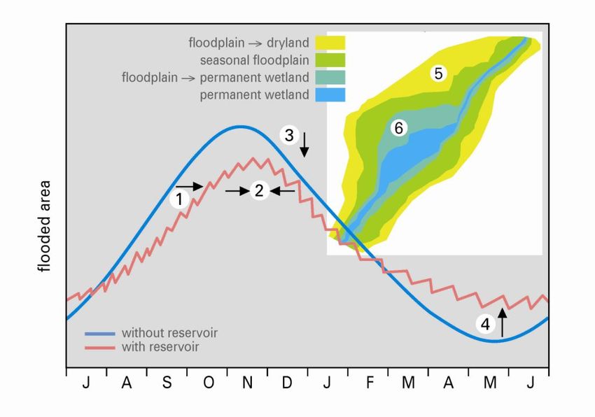
A&W-report 1739 Water sharing in the Upper Niger Basin

Contents

1   Introduction                                                                                        1
    1.1 Food security and water management in Mali                                                      1
    1.2 Green growth and water management                                                               1
    1.3 Scope and outline of this study                                                                 2
2   Constraints to water use                                                                            3
    2.1 Rainfall                                                                                        3
    2.2 River flow                                                                                      4
3   Water use                                                                                           5
    3.1 Seven interventions in the Upper Niger                                                          5
    3.2 Benefits of the interventions                                                                   9
4   Losing the Inner Niger Delta?                                                                      13
    4.1 Flooding                                                                                       13
    4.2 Floodplains                                                                                    14
    4.3 People                                                                                         16
    4.4 Rice cultivation                                                                               17
    4.5 Livestock                                                                                      18
    4.6 Fishery                                                                                        18
    4.7 The Inner Niger Delta, a flood-dependent economy                                               19
    4.8 The Inner Niger Delta, a flood-dependent ecosystem                                             20
5   Water resources management in Mali                                                                 23
    5.1 Administrative and institutional system                                                        23
    5.2 Past and ongoing initiatives                                                                   27
    5.3 State of IWRM in the Upper Niger Basin (Mali)                                                  29
    5.4 Lessons learned                                                                                33
6   Options for IWRM and green development                                                             34
    6.1 Stakeholder engagement                                                                         34
    6.2 Water for food and ecosystems                                                                  34
    6.3 Efficient water use                                                                            35
    6.4 Water sharing for the Inner Niger Delta                                                        36
    6.5 Sustainable use of natural resources                                                           37
    6.6 Nature-inclusive design of new cultivations                                                    37
    6.7 Actions                                                                                        38
7   Used references                                                                                    40

    Appendix 1   Organizations and institutions involved in water management                           43
    Appendix 2   Past and ongoing projects and studies on IWRM                                         46
A&W-report 1739 Water sharing in the Upper Niger Basin
A&W-report 1739 Water sharing in the Upper Niger Basin   1

1       Introduction

1.1     Food security and water management in Mali

Since the Great Drought in the 1970s and 1980s the promotion of food security has become
one of the top priorities in the Sahel. To deal with the unpredictable climatic conditions, and to
meet the demands of growing populations, countries as Senegal, Mali, Niger and Burkina Faso
are stimulating the rural sector to improve inland food production. Enhancement of the inland
food production is complicated, however, as soil fertility in the Sahel is low, water scarce and
the agricultural sector underdeveloped. Large scale irrigation of low lying parts of river basins is
an important option to raise food security: the production is independent from rainfall and
lowers the dependency on foreign imported cereals. In Mali large scale irrigation has been
realized in Office du Niger which today is the rice granary of West Africa (Bonneval et al. 2002,
Zwarts et al. 2005).

Mali is facing a huge challenge. Promotion of food security is of top priority for which a further
expansion of Office du Niger is one of the most promising options. This implies land
development and additional water extraction from the Niger. At the same time water is needed
for the booming energy demand. Water, however, is limitedly available and crucial to other
sectors of the environment, not in the least the flood-driven ecosystem and economy of the
downstream Inner Niger Delta. Almost 1,5 million fishermen and farmers make a living in the
delta. Their livelihoods - fishing, rice growing and livestock grazing – depend on the annual
floodings. Globally, the Inner Niger Delta is an ecological hotspot and the region is of crucial
importance for Eurasian migratory bird populations. Tapping the Niger´s flow is, therefore, not
without consequences. In a nutshell, this shows that integrated water resources management
is of utmost importance in the Upper Niger Basin, where food security, water management and
ecosystem services are closely linked.

1.2     Green growth and water management

The sustainable development of (rural) economies and poverty eradication is recently promoted
under the umbrella´s of green growth, green development or green economy. A Green
Economy is defined by UNEP (2011) as ´one that results in improved human wellbeing and
social equity, while significantly reducing environmental risks and ecological scarcities.´ In
particular in growing economies this approach can lead to increased investments in sectors
that enhance the earth’s natural capital or reduce ecological scarcities and environmental risks
(UNEP 2011). What new is to this development is the increased involvement of the private
sector. Is the concept of green development also a promising option for African river basins?

A green development in African river basins is strongly connected to integrated water
resources management (IWRM). In African river basins the limited water resources play a
pivotal role in economic growth, both where the rural and urban communities are involved. This
appears from the competition for water resources between the agricultural and energy sector,
but it becomes even more prominent when ecosystem services are involved. Especially in
Africa rural communities depend on ecosystem services for their livelihoods. These services,
including biodiversity, are increasingly recognised as important sustainability criteria for
development. The question arises whether green growth opens windows to developments or
initiatives that balance water use between sectors in such a way that sustainable room is left
for ecosystem services and natural capital.
2     A&W-report 1739 Water sharing in the Upper Niger Basin

To investigate this for African river basins, WWF initiated a project, commissioned by the
Directorate for International Cooperation (DGIS) of the Dutch ministry of Foreign Affairs, to
develop a framework for green development in relation to water management (WWF 2012).
The project is aiming to identify the best approaches, based on an ecosystem approach, to
integrate food security, land and water use, and other sectors. This quest can be seen from two
perspectives: 1) from the context of developing river basins in which IWRM is the 'green motor'
of the economic growth, and 2) from the viewpoint of new initiatives in a river basin which
support or stimulate a green development. Although the project may identify smart solutions for
integrated water management, the focus lies on the way to implementation. As far as
appropriate, the concept draws on lessons learned in three African river basins: Lake Naivasha
(Kenya), Lower Zambesi basin (Mozambique) and the Inner Niger Delta (Upper Niger Basin,
Mali). The current report summarises the case of the Upper Niger Basin in Mali.

1.3       Scope and outline of this study

The geographical scope of this study encompasses the Upper Niger Basin in Mali, focussing on
the downstream Inner Niger Delta up to Tombouctou (Fig. 2.1). This case study is focussing on
the core bottlenecks and options with regard to IWRM and green development in the basin and
steps which have been set – in terms of knowledge development, stakeholder engagement,
implementation (emerging practices) - towards a more integrated approach. This report does
not deal with related Sectors to water resources management as water sanity and purification.

Chapter 2 summarises the water resources in the Upper Niger Basin. It succinctly pictures the
upstream-downstream chain of related factors: rainfall – river discharge – flooding, whereas In
Chapter 3 the impact relation with the main infrastructure in the Upper Basin is worked out
(water use). In Chapter 4 the flood-dependent ecosystem and economy of the Inner Niger Delta
is presented. The future of the delta as a floodplain directly depends on the management of
water resources in the Upper Niger Basin. The flood-dependent relationships with the
ecosystem services and production of natural resources are highly relevant to green
development.

Chapter 5 shortly pictures the administrative and institutional system for water management in
the river basin. In addition, a synthesis is given of past and ongoing initiatives – projects,
studies, processes – focussing on integrated water resources management in the Upper Niger
Basin; the situation of IWRM is tested against a set of criteria which are important for change,
and derived from the main report about green development (WWF 2012). The main lessons
learned are summarised in Section 5.4. This report is concluded by putting forward promising
options for ´greening´ the future development in the Upper Niger Basin and, by making use of
the lessons learned, possible strategies and activities are formulated (Chapter 6). Special
attention is paid to the process of stakeholder engagement and ways for implementation of
technical solutions which are already on the table.
A&W-report 1739 Water sharing in the Upper Niger Basin   3

2       Constraints to water use

In Mali, a land-locked country, rainfall is the sole water resource, although it varies from almost
nothing in the north (Sahara desert) to superabundant in the south (Fig. 1). The annual
variation in rainfall is huge and unpredictable. The surplus of rainfall in the south is being
drained by the Niger river and its tributaries flowing into the Inner Niger Delta, one of the largest
floodplains in the world. Besides a part of the Upper Senegal Basin in the east of the country,
the Niger system and floodplains form the main water system in Mali. This Chapter describes
the rainfall and river flow in the Upper Basin of the Niger, showing the natural constraints,
including climate change, set to the water use described in the next Chapter.

                                                                       Fig. 2.1. The annual rainfall
                                                                       (mm/year) in the basin of the
                                                                       Upper Niger shown as eight
                                                                       different zones. The Inner Niger
                                                                       Delta is situated between Mopti
                                                                       and Tombouctou. From: Zwarts et
                                                                       al. (2005).

2.1     Rainfall

The inter-annual rainfall in West Africa is highly variable. During the 20th century, three periods
of drought can be discerned: the first two - 1900-1915 and 1940-1949 respectively - were
followed by periods of improved rainfall. Again 30 years later another drought occurred, but
instead of an expected recovery in rainfall, there was a further decline until 1984. This last
period is called the Great Drought in West Africa – La Grande Sécheresse (1972-1993). Since
then, rainfall has gradually improved somewhat. Over the last centuries there have been similar
climate epochs: from 800 to 1300 it was thought to have been relatively wet, to be followed by
a drier period from 1300-1450, a wetter period until 1800 and a gradual decline since then.

Climate is an important driver of change. The daily rainfall in Saint Louis (Senegal) has been
registered since 1848. Altogether in seven stations the measurements started in the 19th
century. Although the annual rainfall is highly variable, the downward trend in these stations is
evident, showing an average long-term decline of about 3% per year. The rainfall in Africa
largely depends on the sea surface temperature of the oceans, but the rapid changes in land
usage and loss of vegetation cover in the Sahel have enhanced the decline of the rainfall.

Since there are several competing mechanisms leading to more or to less rain in the Sahel, it is
extremely difficult to predict whether there will be more or less rainfall in the Sahel. One of the
4 A&W-report 1739 Water sharing in the Upper Niger Basin
problems with the available Global Circulation Models is that they are not able to capture the
Great Drought in the 1980s. Nevertheless, 16 of the 19 models being used in the recent IPCC
Report do reproduce a drier Sahel at the end of the 20th century. Aerosol emissions from
industrialization, causing global dimming, and thus cooling in the northern hemisphere, play a
role in causing the Sahel drought. At least 30% of the observed negative rainfall trend over the
1930–2000 period was estimated to be externally forced, most likely anthropogenic.
In conclusion, still much is uncertain, but an ongoing decline of the rainfall, the sole water
resource, in the Sahel seems to be likely. Since human influences are assumed to be
substantial in the global climate change, this gives reasons to worry about the future.
2.2 River flow
The rivers in West Africa demonstrate huge between-season variations in discharge, being 80
times larger in the short intense rainy season than in the late dry season. Without this large
seasonal variation in rainfall there would be no seasonal floodplains and thus no Inner Niger
Delta. The flooding of the Inner Niger Delta is determined by the inflow from the Niger and Bani
Rivers, which in turn relate to the rainfall experienced 600-900 km SW of the area (Fig. 2-1), in
the Guinean Highland where it starts to rain April to reach a peak in July and August.
The Niger and tributaries rise in the Guinean Highlands, except the most northerly branch, the
Tinkisso, which originates in the Fouta-Djalon. The main tributary to the Niger, the Bani, drains
southernmost Mali and the northeastern corner of Ivory Coast. After the Bani flows into the
Niger near Mopti, at the southern edge of the Inner Niger Delta, there is no further run-off from
eastern Mali and Niger. Consequently, evaporation gradually diminishes the river flow.
2
The total catchment area of the Bani (129,000 km ) is nearly as large as the rest of the Upper
2
Niger Basin (147,000 km ). Yet the discharge of the Bani is less than half of the Niger, because
the Bani sub-basin receives less rainfall than the other sub-basins of the Upper Niger. The
annual rainfall in the Bani catchment area usually varies between 1000 and 1200 mm. The
3 3
Bani’s flow in September fell back from 3000 m /s to only 250 m /s during the drought in the
early 1980s, but subsequently gradually increased again. The long-term effect of a series of dry
years on the flow of the Bani is evident. The Bani was a river with a fully natural flow until 2006
when the Talo dam became operational.
Since 1922, the average annual rainfall in the Upper Niger has varied between 1300 and 1600
mm. The trend resembles those shown for the Bani. But where the Bani lost 80% of its flow
during the Great Drought, the decrease in the Niger was slightly less than 50%. The
comparison between rainfall and discharge in the Upper Niger basin reveals a large variation in
river flow and a much smaller variation in rainfall. This larger variation in river discharge is an
important ecological asset of the Sahel. The explanation hinges on the cumulative effect of
rainfall on river discharges: dry years lower the discharge, but it takes a number of wet years to
attain subsequently a high discharge. In other words: river discharges not only relate to rainfall
in the preceding wet season, but to a large extent also to earlier wet seasons. After a series of
dry years, the discharge is insufficient to keep the groundwater table at a certain level; in turn a
low groundwater table increases infiltration of surface water.
In conclusion, a continuing decline of the river flow of the Niger and Bani is to be expected
given the anticipated climate change. The next Chapter shows that the flow will decrease even
more due to the planned interventions in the Upper Niger Basin.A&W-report 1739 Water sharing in the Upper Niger Basin 5
3 Water use
Many people in Mali, in particular the rural communities, depend for their living on the Niger
and Bani flows. The large annual variation in river flow leads to a simultaneous variation in the
production of food (natural resources). To make the economy of Mali less dependent on
climate and river flow, hydro-agricultural irrigation schemes have been developed. At the same
time, the need for electricity has increased, leading to the (planned) construction of
hydroelectric dams. This Chapter describes the impact of these dams and irrigation schemes
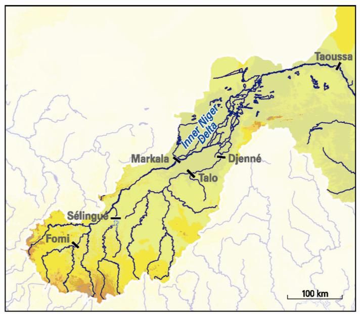
(Fig. 3-1) on the river flow and shortly indicates the (expected) economic functions.
Fig. 3.1. The Upper Niger with the
Niger River and its branches.
Sélingué, Markala and Talo are
existing dams. Fomi is still in study,
Djenné is being build, and for the
Taoussa dam preliminary building
works have started.
.
3.1 Seven interventions in the Upper Niger
Sélingué
Since 1982, the flow of the Upper Niger has not been fully natural due to the construction of the
2 3
Sélingué reservoir in the Sankarani. The Sélingué reservoir covers 450 km when full (2.1 km ).
The (natural) flow is reduced by, on average, 61% in August and by 36% in September due to
the filling of the reservoir. In contrast, when water is released from the dam in the dry season,
the outflow between February and April is about three times the amount of the natural flow. 1.8
3 3
km of the annual flow is withheld by Sélingué in August and September, of which 0.5 km is
3
lost due to evaporation. In the dry season 0.2 km per month is released, as a consequence of
which the (natural) river flow roughly doubles in these months. The water stored annually in the
reservoir amounts to 10-20% of the peak flow in wet years, but to 20-30% in dry years.
The difference between the inflow into and outflow from the Sélingué reservoir is a direct
measure of the impact of the Sélingué reservoir on the monthly river flow. In a year with a large
inflow the reservoir is already filled for a large part in August, but in a dry year relatively more
water is withheld in September. Furthermore, the annual variation in river flow has hardly any
impact on the seasonal pattern of storing and releasing the water.6 A&W-report 1739 Water sharing in the Upper Niger Basin
3
To irrigate the rice fields immediately downstream of the Sélingué dam (1400 ha) 1.1 m /s is
taken from the river; the total annual rice productions amounts to 17,000 tonnes. The
hydropower plant results in a production of electricity varying between, on average, 10 GWh in
January - February and 20 GWh in August - November. The annual total production varies
since 1983
Small irrigation schemes in the Upper Niger
Office Haute Vallée Niger (OHVN) manages, beside the irrigation scheme of Maninkoura (850
ha) 40 km downstream of Sélingué, 28 other irrigation areas with a total surface of 12.000 ha
and plans to make seven other rice polders (with a total surface 3700 ha) further downstream
along the Sankarani. The planned weir near Kourouba in the Sankarani would enable to irrigate
the rice fields of Maninkourou (5000 ha). The total annual water intake to irrigate the 17,776 ha
3
of rice polders along the Upper Niger may be roughly estimated at 18 m /s. This will increase to
3
20-25 m /s if the Kourouba dam is functional. The irrigated area of Baguinéda near the Sotuba
dam just downstream of Bamako has a surface of 2400 ha. The water consumption varies
3 3
between 3 m /s in the dry season and 9.5 m /s in the wet season. The rice production at
present amounted to 18,700 tonnes in the areas managed by “Office du Perimetre Irriguee de
Baguineda” (OPIB) and 10,800 tonnes in Baguinéda.
Office du Niger
The irrigation zone managed by Office du Niger is possible thanks to the Markala dam, a weir
across the river used to raise the water level 5.5 m above the lowest water level of the river.
This enables irrigation under gravitation. The irrigation zone of Office du Niger is located in the
Delta mort, an ancient branch of the Niger. The Markala dam has been operational since 1947,
but it took many years before the irrigation scheme was developed.
3
The water intake, as registered by Office du Niger, amounts to 2.69 km per year, equivalent to
3
86.5 m /s and does not differ for dry or wet years. Despite the gradual extension of the irrigated
zone, the total water extraction remained at the same level between 1988 and 2011. Over the
3
same period, the annual river discharge at Markala varied between 539 and 1229 m /s. As a
consequence, water use by Office du Niger is not more than 7% of a high river flow (1995), but
this may increase to 16% when the flow is low (1989). The monthly water use by Office du
3 3
Niger varies seasonally and is 60 m /s in January, gradually increasing to 130 m /s in October,
3 3
decreasing to 90 m /s in November and 50 m /s in December. The available water supply
3 3
varies between 100 m /s in March and 3200 m /s in September. Hence 60% of the flow is
tapped in March against only a few percent in September.
The irrigated zone in the Office du Niger has gradually been extended. The zone with irrigated
rice fields during the wet season has increased from 40,000 ha in the 1980s to 77,000 ha in
2007. Since in the same period the yield of rice has increased from 2 to 6 tonnes/ha, the total
rice production in the wet season has shown an even larger boost from about 10,000 tonnes in
the 1970s to more than 450,000 tonnes in 2008/09. Including Sukala (4200 ha with sugarcane),
the irrigated area has increased to 84,140 ha in 2009 and a further extension is planned. The
Plan d’Action du Schéma Directeur de Développement de la Zone Office du Niger (2009)
provides a detailed planning. The irrigated zone will be extended by 33,595 ha in 2010-2012
and 71,888 ha in 2013-2020 (planned), by which in 2020 the total irrigated zone will have
reached a surface area of 193,394 ha. In addition, a potential extension is mentioned of
105,483 ha in 2010-2020.
The expansion of the Office du Niger so far has been able without an increase of the total water
consumption in September – February, but the intended extension is only possible at a higherA&W-report 1739 Water sharing in the Upper Niger Basin 7
3
water intake. The water consumption in September and October amounts to 120-130 m /s and
3
has never been higher than 146 m /s during a month. This limit is determined by the
dimensions of the hydrological system. The water from the river just upstream of the weir is
3
directed through a large main canal with a maximum capacity of 200 m /s to Point A (the
capacity of this canal should be upgrade to 350 m³/s in the frame of the Millennium Challenge
Corporation funded by the USA), from which it is divided between three smaller canals:
3
Canal du Sahel ( max.100 m /s) discharging northwards into Fala de Molodo leading to
the irrigated areas north of Niono.
3
Canal Costes-Ongoïba (max. 13 m /s) supplying the sugar plantation of Siribala.
3
Canal du Macina (max. 45 m /s) leading into Fala de Boky-Wéré, running in an easterly
direction towards the polders of Macina.
The first priority of Office du Niger has been so far to enlarge the capacity of the Canal du
3 3
Sahel (from 100 to 190 m /s) and of the canal du Costes-Ongoïba (from 13 to 45 m ) and not to
3
increase the flow along the canal du Macina (45 m /s). This means that the total maximal water
3 3
extraction would increase from 130 m /s in September-October to 280 m /s. The intended
scheme has changed by a concession given in 2008 to Malibya, to develop 100,000 ha east of
Office du Niger. The Chinese CGC constructed the last 3 years a 40 km long canal to halfway
3
the Canal du Macina, with a capacity of 127 m /s. To feed this new canal, also the western part
of the Canal du Macina and the main canal have to be enlarged. All in all, the total water
3
consumption by Office du Niger would arrive at about 400 m /s, and even more if all other
concessions are taken into account (Mali Plan de Zonage des Amenagements et Projections;
October 2011).
Bigger channels may enable Office du Niger to take more water and thus to extend the
irrigation zone. However, this will only be possible in the period July-February, but not in
March-July. In the present situation the river discharge sets a limit to the water consumption in
March-July. During these months the water intake has increased the last 15 years by about
30%. A further increase is hardly possible, since the river discharge cannot be used completely
for irrigation to avoid serious ecological and economic problems downstream of the Markala
3
dam. The minimal required water flow passing the weir is set at 40 m /s. During recent years,
this lower limit is passed already between mid-March and mid-May. In other words, water is the
limiting factor.
In conclusion, Office du Niger has become the granary of Mali. It consumes at present 7% of
the river water in a year with a high flow, but 16% in a year with a low flow. The seasonal
variation is even larger, with 60% taken in March and a few per cent in October. Office du Niger
has the ambition to grow but faces two constraints: the capacity of the canal between the Niger
and the irrigation areas sets a limit to the water intake in July-November, whereas the low river
discharge during the dry period sets a limit to the present water use in March-May. The
implications for the water management and possible solutions are discussed below.
Fomi
The Fomi dam is planned to be constructed in the Niandan tributary in Guinea-Conakry. The
reservoir is meant for hydropower in combination with irrigation and flood control. There are still
several scenarios (Coyne & Bellier et al. 2009). If the Fomi reservoir will be kept at 390 m
above sea level, the lake will have about the same surface area as Lac Sélingué (varying
2
seasonally between 247 and 507 km ), but it will be much deeper (12 m, on average at high
water). That is why it will contain, if full, three times as much water as the Sélingué reservoir
3
(6.16 km ). Another difference between Sélingué and Fomi is that the annual inflow into the8 A&W-report 1739 Water sharing in the Upper Niger Basin
3
Fomi reservoir (7.07 km ) would be nearly twice as low as the average inflow of the Sankarani
3
(12 km ) into the Sélingué reservoir.
The Fomi reservoir will be managed in about the same way as Sélingué, as far as possible
given the limitation of the relatively low inflow compared to the large volume. To fill the reservoir
3
between July and October 0.29, 0.69, 0.80 and 1.94 km will be stored, respectively. The stored
water is released between December and June, as a consequence of which the future flow of
the Niandan River will become in March and April ten times larger, on average, as the natural
flow. The expected potential annual electricity production is estimated at 243 GWH, on average
being variable however, due to the variation in annual flow. In a dry year the production will be
not higher than 136 GWh.
In conclusion, the electricity produced at Fomi will be 20% larger as Sélingué, although
showing a larger annual variation due to the limited inflow. The Fomi reservoir will have a large
impact on the flow of the Niandan: from July to October. 37% of the inflow into the reservoir is
withheld, whereas as the outflow in March-April will become ten times larger as in the natural
situation.
Talo
The Talo dam, built in 2006 in the Bani River, is meant to facilitate irrigation under gravitation in
the plains between Tounga and San. The planning was to develop 20,320 ha, of which 16,030
irrigated rice fields; the rest is planned tol be converted into bourgou (water meadows) and fish
2
ponds. The reservoir would remain small (maximum surface 50 km , maximum volume 0.18
3 2
km ) but, as can be seen on Google Earth, its surface may be as large as 80 km , and even
larger because it actually reaches the main road between San and Bla. The present effect of
Talo on the river flow is obvious from the seasonal variation in the water level downstream
upstream at Douna and downstream at Beleni-Kegny. Since 2005, the peak flood level in
Beleni-Kegny has been reduced by about 50 cm.
The expectation is that due to the Talo dam, the flow of the Bani at Mopti between July and
3
October will be reduced by 0.39 km , being a likely underestimation.
Djenné
The Djenné dam, to be constructed south of the town of Djenné, is intended to counteract the
water losses in the lower Bani caused by the Talo dam. Moreover, low dikes will be made along
the Bani and along the Niger near Kouakarou. It is the intention to develop rice polders west of
the dam and to rehabilitate the rice polders near Djenné and Sofara, and between Fatoma and
Kouna. Part of the new perimeters will be rarely flooded, however, e.g. the zone along the Bani
River near the barrage itself.
2 3 2
Due to the dam a reservoir of 150 km and 0.357 km will come into existence, 245 km will be
flooded and assumed to be covered by a vegetation of bourgou. Two alternatives have been
2 2
worked out: either rice will be grown on 435 km with a controlled submersion, or 100 km will
2
have a full-water-control and 335 km controlled submersion. The investments are high with 1.0
and 1.8 million CFA/ha, respectively for both variants. In a year with an average flow, the water
level in Sofara will be reduced by 30-55 cm in September, but in a dry year by 64-90 cm. The
impact is less further downstream. In Mopti, where the Bani flows into the Niger, the water level
is yet reduced by 5-15 cm in a year with an average flow and by 17-27 cm in a dry year.
In conclusion, a part of the southern Delta will be artificially flooded, but this will be at the
expense of floodplains downstream of the dam.A&W-report 1739 Water sharing in the Upper Niger Basin 9
Taoussa dam
The Taoussa dam is projected at 130 km upstream of Gao and 280 km downstream of
Tombouctou. To maximize the production of electricity, the lake will be filled during the flooding
period (August-January) and emptied during the deflooding period in the rest of the year. The
minimum working level will be some 40 cm above the lowest gate level, by which the seasonal
variation in water level will be about 4 meter, being more than the natural variation in extreme
dry years but less than the variation in wet years.
2
As a consequence of the dam, a lake of 1572 km will come into existence, being, on average,
about 300 km long, 5 km wide and 3 m deep. The flooding system in the Inner Niger Delta will
not be affected, but the impact will be very large in the Niger River closer to the dam: the water
level will be raised about 30 cm in Koryoumé, 70-80 cm in Gourma and 110-120 cm in Bamba.
These figures refer to the high water level, but what will change in the flooding dynamics at a
lower water level? This all depends on the water management. If the gates would remain
closed in the dry period, the expectation is that the northern Delta will only be partly be
deflooded and that even the water level in Mopti will remain relatively high during the dry
period. Although, this is not more than a theoretical possibility, the Taoussa dam has a
potentially huge impact on the functioning of the Inner Niger Delta.
On a short and middle long term the objectives of the dam comprise the enlargement of the
level of self-subsistence in the region through the restoration of the local economy (agriculture,
fisheries, pastoralism) and the restoration of groundwater levels and environmental conditions
comparable to the pre-drought situation.
In conclusion: the Taoussa dam will have a large impact on the seasonal river dynamics 100-
200 km upstream. In the envisaged management the lake will be emptied during the deflooding
period, by which the seasonal variation of the water level will be simulated, although at a higher
level. The impact downstream are very large but beyond the scope of this study.
3.2 Benefits of the interventions
The construction of dams and weirs in the Niger river are meant to develop the agricultural and
hydropower potential of the river basin. This Section first summarises the benefits from the
(expected) electricity generation and then the expected higher food production through
irrigation. Wood and charcoal are still important as source of energy for many people in Mali,
but the demand for electricity is growing fast. Hydropower produces cheap energy (9 Euro
cents/kWh), being 2-3 times cheaper than power generation from fossil fuel. Moreover, it
contributes to the reduction of greenhouse gas emissions.
Electricity generation started since 1966 at Sotuba, a low weir just downstream of Bamako,
which produces 40 GWh. The Selingué reservoir generates 200 GWH since 1982 (although it
was less in the first two years of its existence). The large Manantali reservoir in the Upper
Senegal River (W Mali) was constructed between 1982 and 1988, but began to produce
electricity not before 2001. Its annual production amounts to 740 GWh (being not more than
42% of the theoretical maximal production), of which 55% or 410 GWh is delivered to Mali,
30% to Senegal and 15% to Mauritania.
The total generation of hydropower available for Mali has increased from 40 GWh per year in
1966 to 240 GWH in 1982 and 650 GWh per year presently. This would further increase to10 A&W-report 1739 Water sharing in the Upper Niger Basin
1020 GWh, including the planned Fomi dam (374 GWh), and 1250 GWh if the Taoussa dam
(still in study; 230 GWh) would be constructed.
The effective power consumption in Mali increases by 7% per year since 1980 (data of ENP).
Up to now, the energy demand could be covered more or less with the existing hydropower.
Some cities in the Sikasso region, in the southern part of Mali, have been interconnected to
electricity produced by dams in Ivory Coast. Nowadays this interconnection program is
underway and will cover more cities such as Koutiala, Bla, Segou, etc. Fomi would cover the
growth for some other years if all energy would be transported to Mali. In fact, the majority of
generated electricity by Fomi will be used in Guinée-Conakry. The electricity generated by
Taoussa would be equivalent to the growth in one year in the 2010s. There are plans for 19
Malian hydropower stations in the Upper Niger and in the Bani. Would they be realised, they
will in total produce 5100 GWh annually. This will be enough to cover the growing demand for
another couple of years, but not more than that (Fig. 3-2).
Fig. 3.2. Annual power consumption in Mali for the period 1980-2001 and expected consumption up to
2030. In the bar on the left the annual electricity production of the existing (Sotuba, Sélingué) and planned
(Fomi, Taoussa still in study) is shown.
Next to the production of electricity the agriculture sector, producing food for the urban and
rural population, may benefit in several ways from dams:
1. With irrigation under gravitation it is cheap for farmers to transfer water from the river to
water their land (no expensive fuel costs).A&W-report 1739 Water sharing in the Upper Niger Basin 11
2. Irrigation makes farmers independent of rainfall and flooding. In this way, a more or less
secured food production is achieved in a climate being highly variable.
3. The yield may be enhanced considerably. In traditional rice farming systems - rain fed or
flood-dependent - one family with on average 3,5 active members exploits about 5-6 ha,
yielding 1-2 tonnes/ha per year Rice farmers in the irrigation zone of Office du Niger rent
about 2 ha on which they produce 5-6 tonnes/ha per year.
4. The annual production may be further enhanced by double-cropping, having one
harvest after the wet season and the other in the dry season.
3
The Markala dam allows Office du Niger to take 2.7 km per year from the Niger. The water use
as fraction of the river discharge varies between some per cent in the wet season to over 60%
in the dry season. The water use in the dry months is about equivalent to the water released
from the Sélingué reservoir. Hence, the seasonal variation in the flow of the Niger is so large,
that the current large-scale irrigation in the dry season is only possible because of a second
dam (Selingué) further upstream.
The planned extension of Office du Niger is constrained by the available amount of water in the
dry season The Fomi dam is considered as an opportunity to solve the latter problem. Sahelian
rivers are characterised by a huge seasonal variation in their discharge. Dams regulate the
river flow by storing water at peak flood levels and subsequently release it in the dry season.
Seasonal floodplains disappear by removing the flood pulse (Fig. 3-3). The next Chapter
describes how far this is, or will be, the case.
Fig. 3.3. Dams in river basins in (semi)arid climates as in the Sahel have in general six main effects: 1)
the timing of the flood will be retarded, 2) the flood peak will be smaller, 3) the flood peak will be lowered,
4) the river discharge during the dry period will be increased, 5) floodplains will be reduced in favour of
drylands, 6) permanent wetlands infested by invasive plant, mainly Typha, will increase (from Zwarts et al.
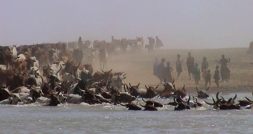
2009).12 A&W-report 1739 Water sharing in the Upper Niger Basin Rural communities in the Inner Niger Delta depend on flooding for their local economy, notably rice growing, fishing and cattle grazing. Bourgou is used a fodder for cattle – photo Leo Zwarts.
A&W-report 1739 Water sharing in the Upper Niger Basin   13

4       Losing the Inner Niger Delta?

The ecosystem and economy of the Inner Niger Delta depends on the annual flood. The higher
the flood, the larger the floodplains and the higher the production of natural resources on which
the rural communities rely. These relationships could be quantified since long series of data are
available of flood levels, fish production, rice production and cattle numbers. In this Section we
use these data to picture the flood-dependent ecosystem and economy of the delta, and show
this system is and may be interrupted by upstream interventions. The data series have been
analysed by Zwarts et al. 2007 and 2009; see also there for extensive references

4.1     Flooding

The Inner Niger Delta is one of the largest floodplains in Africa. The Delta not only stands out
because of its size, but also due to its hydrological dynamics. Starting in July, the water rises
about 4 m in 100 days. In years of high river discharge, peak level may be 6 m higher than a
few months previously. The large between-year differences in flooding make the system even
more dynamic. In a year with a high peak flood level in the Inner Delta, the flood lasts four
months longer than in a year with a low flood: the wave comes in a wet year one month earlier
and continues for an additional three months. When the water level starts to rise in July in the
southwestern part of the Delta, the plains in the northeast are still dry. By the time the northern
plains become flooded two months later, the water level is already declining in the south.

The topographical maps of the Institut Géographique National (IGN) reveal that the inundation
                                                    2                    2
zone of the Inner Niger Delta measures 36,470 km , including 5340 km of levees, dunes and
                                                                                           2
other islands within that area. They also show that water coverage declines from 31,130 km in
                         2
wet periods to 3840 km in the dry period. The entire floodplain area is included in the 41,195
   2
km designated as a Ramsar Wetland Site of International Importance in January 2004.
Topographical maps show the maximal flooded zone, but the area actually inundated varies
considerably between years. Zwarts & Grigoras (2005) used satellite images to construct a
digital flooding model, covering the range of water levels between -2 and +511 cm, as
measured on the gauge at Akka in the central lakes.

There is a very good fit between the water level, such as measured in Akka (situated in the
                                                                                  2
middle of the Inner Niger Delta) during rising water and the flood extent (km ). In 1984, the
water level at Akka did not exceed 336 cm and the flooded area was limited to a mere 7800
    2
km . In contrast, in 1957 and 1964, the water level at Akka reached the very high level of about
                                                2
600 cm, leading to a flooded area of 22,000 km . It should be noted that this is still substantially
                                                 2
smaller than the total floodplain of 31,000 km as shown on the IGN maps. This apparent
discrepancy is caused by the shallow northward slope of the floodplain that delays flooding in
the north with two-three months; by that time the southern floodplain has already been drained
of water. Because the remote sensing analysis is based on actual water coverage, the area
flooded at any one time is always less than the total area flooded in the course of a year.

The flood level and flood extent are determined by the inflow of the Bani (flow at Douna) and
Niger River (flow at Ke-Macina). The peak flow in September showed a huge variation since
                                                              3                     3
the measurements started at Douna in 1922: between 254 m /s in 1984 and 3470 m /s in 1929.
The variation is less extreme for the Niger at Koulikoro, known since 1906: the September flow
                                      3                                               3
was at a minimum in 1984 (1649 m /s) and reached its maximum in 1928 (7586 m /s). The
maximum water level in Akka, usually reached in November, can be predicted reliably from the
14 A&W-report 1739 Water sharing in the Upper Niger Basin
average river flow in July, August, September and October combined for both rivers. The
existing and planned reservoirs have a cumulative impact on the river flow and, consequently,
on the flooding of the Inner Niger Delta. Since the amount of water consumed hardly differ for
dry and wet years, the relative impact of these infrastructures on the river flow becomes more
pronounced in years with a poor discharge.
The average flow in August-October for Bani and Niger between 1982 and 2004 has varied
3 3
between 1482 and 4618 m /s, equivalent to a total seasonal flow of 16 and 49 km respectively.
3
Without Sélingué the average flow in August-October would have been 184 m /s higher and
3
without irrigation by Office du Niger 108 m /s. Due to the reduction of the flow because of
Sélingué and Office du Niger the flood extent has already declined by, on average, 5.5% and
2.9%. The Fomi dam will cause a further reduction by 5.8%, the Talo and Djenné dams by
2.5% and the extension of the Office du Niger by 4.9%.
Over the past century, rainfall in the Sahel and the flooding of Inner Niger Delta alternate
between extended periods of drought and abundance. The annual rainfall and the flooding
fluctuate in accordance, but apparently the floods are irreversibly smaller than in the past,
independent of the rainfall in the same year. This may be partly attributed to water loss due to
the construction of the Sélingué reservoir in 1982 and the water taken from the river for
irrigation. A further reduction of the Inner Niger Delta is to be expected given the ongoing
extraction of river water upstream of the Inner Niger Delta (and expected climate change).
4.2 Floodplains
The Inner Niger Delta is vegetated with plant and tree species that are adapted to steep
fluctuations in water level, seasonal flooding and long dry periods. Wild rice Oryza barthii, for
example, produces 2-metre-long stems and occupies the zone where the water column
reaches up to 2 metres. Another grass species, Echinochloa stagnina, locally known as
bourgou, has stems up to 3-6 metres and grows where the water depth is 4 m on average.
During flooding, wild rice, bourgou, and also Vossia cuspidata (known as didere in the Delta),
form huge floating meadows. Bourgou has a high nutritional value and is therefore also planted
by local people to be used as fodder for cattle during the dry period. People are cultivating an
increasing proportion of the floodplains to grow rice. Cultivated rice Oryza glaberrima requires
the same water depth zone as do wild rice and flood forests, and so extension of cultivated rice
fields occurs at the expense of natural habitats. For similar reasons, forests, except for tiny
fragments, have now been removed.
The highest floodplains are covered by a tall grass species, Black Vetivergrass Vetiveria
nigritana, and locally by Acacia seyal forests (Red Acacia or Shittim Tree). The lowest
floodplains often become green as soon as a dense vegetation of grasses and Guinea Rush
Cyperus articulatus emerges after the flood has passed. These green floodplains, however, are
short-lived and quickly transform into dry dusty steppe with hardly any vegetation, a combined
effect of the withering sun and intensive grazing by cattle, sheep and goats. Twenty percent of
the 20 million goats and sheep and 40% of the five million cows in Mali are concentrated in the
Inner Delta and its surroundings during the dry period. During the droughts there was a shift in
the distribution of bourgou, didere and rice following the changes in maximum flood level. For
instance, the low-lying Lake Walado has always been a lake where floating vegetation was
restricted to the border zone. The lake was colonised by bourgou in 1985 and 1986, after the
flood level had been low for a number of years. In the same period that bourgou settled in Lake
Walado, elsewhere much larger bourgou fields were replaced by didere.A&W-report 1739 Water sharing in the Upper Niger Basin 15
Given a water depth of 4-5 m, the surface area of optimal bourgou habitat can be calculated for
different flood levels. In 1984, when peak water level reached only 336 cm, none of the
floodplains in the Inner Niger Delta had a water column in excess of 4 m. Bourgou was
outcompeted by plant species as didere in suboptimal habitats with less than 4 m of water.
Relatively small changes in flood level of the Inner Niger Delta thus have a large impact on
plant species restricted to a narrow range of water depths. At a reduction of peak flooding from
420 to 400 cm, caused by the construction of both existing two dams, the surface area of the
2
floodplain was reduced by 12% (from 12 600 to 11 200 km ), but the extent of optimal bourgou
2
habitat decreased with 45% (from 970 to 540 km ). Steeper declines are to be expected when
more dams are built and flood level is further reduced. The emphasis on bourgou is particularly
relevant given its significance as fodder for cattle, as a nursery for fish and also as habitat
where waterbirds concentrate in high densities.
In contrast to bourgou, cultivated rice grows in shallower water 1.0-2.5 m deep. The area where
2
water depth varies between 1 and 2 m measures only 800 km during a low flood (360 cm at
2
Akka), but increases to 4300 km during a high flood (580 cm). Water depth is not the only
criterion for farmers to cultivate an area for rice growing. Rice cultivation is restricted to
substrates that are rather clayey, which explains why rice is almost absent from the sandy
northern half of the Inner Delta. The clay content of the soil being rather high in the southern
section of the Delta, it is here that most rice fields are concentrated. The area of the Inner Niger
2 2
Delta cultivated for rice has increased from 160 km in 1920 to about 1600 km in 1980-2000.
Not only flooding is pivotal to the ecological significance of the Inner Niger Delta, but so is
human exploitation. Over the decades, the Inner Delta has been converted into a semi-natural
habitat by the local inhabitants. For instance, the tenfold extension of the area of cultivated rice
between 1920 and 2000 caused a decline in the area of wild rice. In 1952, most rice fields were
found on sites flooded and deflooded when the water level was 310-410 cm on the gauge of
Akka (average 382 cm). Since the average flood level in the early 1950s amounted to 580 cm,
this implies that the rice fields were then covered by 170 to 270 cm of water at most (on
average 198 cm). In the mid-1980s, peak water level declined to 360 cm, and rice cultivation
was forced down to lower sites flooded when the water level at Akka was between 230 and 360
cm (on average 303 cm, a drop of 79 cm from the 1950s). Despite this move, flooding of the
new rice fields was poor or even non-existent, amounting to 0-130 cm of water. Consequently,
rice production in the Inner Niger Delta crashed from 100,000 ton during normal and good
floods to only 10,000-20,000 ton in the mid-1980s. As floods improved in the late 1990s and
early 2000s, the low-lying rice fields were abandoned in favour of fields flooded at a water level
of 250-360 cm in Akka (on average 321 cm). The accompanying average water depth during
flooding of 149 cm is much better for rice cultivation than the 57 cm in the mid-1980s, but has
not yet attained the level of 180 cm in the 1950s.
In the 1980s farmers adjusted their land use to the prevailing low flood levels by creating rice
fields in the lower floodplains. Didere and wild rice had to be removed, and most of the
remaining flood forests were cut. Of the forests still present in the 1980s, by 2005 seven had
disappeared and eight had transformed into dry forest. Only 18 forests survived, mostly in
degraded form. Two new forests came into existence. Altogether, forests now cover not more
2 2
than 20 km , a small fraction of the several hundreds of km before the 1980s and a tiny
fraction of that existing in pre-colonial times.
Flood forests that had changed into dry forest were exclusively situated on the highest sites,
beyond the reach of most floods. Lost flood forests were restricted to sites that became flooded
when the water level at Akka was above 140 and below 360 cm (median 320 cm). The few16 A&W-report 1739 Water sharing in the Upper Niger Basin remaining flood forests were confined to sites flooded when the water level at Akka was above 150 and below 250 cm (median 190 cm). This fits in nicely with our knowledge of newly-created rice fields of the 1980s; flood forests survived only when situated in the lowest part of the floodplain (120-220 cm on the gauge of Akka), i.e. out of reach of new rice cultivations at 240- 300 cm on the gauge of Akka. Similarly, new flood forests are found only in the very low floodplains (120 to 220 cm). These forests are in danger of conversion into rice fields only when flood levels decline again. In conclusion, the Inner Niger Delta may be considered relatively unspoiled, at least from a hydrological point of view, despite the reduced inflow due to irrigation and water withheld in reservoirs in the Upper Niger. Not only flooding is pivotal to the functioning of the Inner Niger Delta, but so is human exploitation. Over the decades, the Inner Delta has been converted into a semi-natural habitat by the local inhabitants (planting bourgou, converting forest and floating grass meadows into fields with floating rice, etc.). 4.3 People Many people make their living in the Inner Niger Delta. The four national censuses (1976, 1987, 1998 and 2009) show that the Ddelta was inhabited by 0,98 million people in 1976 and by 1,49 million people in 2009, an increase of 52%. In the same period the entire population in Mali grew from 6.39 million to 14.52 million people, an increase of 127%. Thus, in the course of these 33 years, the growth of the population in the Inner Niger Delta was less than in the country as a whole. In 1976, still 15.4% of the Malian population inhabited the ten cercles covering the Delta, but this had declined in the next national censuses to, respectively, 13.4%, 11.3% and 10.3% of the total population in Mali. The rate of population increase was remarkably low in the Delta between 1976 and 1987 (0.6%/year) and between 1987 and 1998 (0.8%/year), but extremely high in 2009 (3.3%/year). A similar difference is present in the national figures, but the contrast between the three periods is much less pronounced. In 1976, the Delta was inhabited by 1,1 million people, of which 230,000 live in cities like Djenné, Mopti and Tombouctou. The remaining 870,000 were thinly distributed over the area. As detailed in previous censuses (1976, 1987), the rural population has remained stable, which is again remarkable in the light of the overall annual population growth of 2.3% in 1976-1998 in Mali. Many people have left the Inner Niger Delta, especially in the northern half where the population has actually decreased by 0.6% per year between 1976 and 1998. Most moved to cities in the region and elsewhere in Mali, or went abroad. The depopulation was a direct result of the prevailing drought and low floods, which make survival difficult. It is obvious that higher flood levels since 1992 has changed the living conditions for the people in the Delta and that many people remained in the area or even returned to their villages. For instance, the population in the cercle Tombouctou, being stable between 1976 and 1998, increased by 7% per year between 1998 and 2009. The largest population increase between 1976 and 2009 occurred in Macina, which may partly be attributed to the ongoing extension of the irrigated rice schemes within this cercle. The rural population in the Delta in 1987 amounted to 0.83 million people of which 0.225 million fishermen. Eleven years later these numbers had increased to 0.88 and 0.28 million, respectively. Thus, about 30% of the rural population in the Delta depends for their living on fishing. In 1957, there were 78,000 rice farmers and, including women and children, 170,000 people depended on rice cultivation for a living. In 1987, the population of farmers had doubled
A&W-report 1739 Water sharing in the Upper Niger Basin   17

(Marie 2002). Thus about 40% of the rural population in the Inner Niger Delta are farmers.
According to RGA (2004-2005), cattle breeding is for 6.6% of the families in Mopti their main
and for 42% a secondary activity. In Timbuktu, these figures are 42 and 23% respectively.

In the past, the rural population in the Inner Niger Delta could be divided into fishermen (30%),
farmers (40%), cattle breeders (30%). However, in more recent years people have started to
abandon their specialisations, due to increasing competition for the available natural resources.

4.4     Rice cultivation

Mali produced in 2007-2008 3.69 million tonnes cereals on 3.28 million ha of arable land. Millet
is mostly produced in Ségou, sorgho and mais in Sikasso and rice in Ségou and Mopti. The
yield of millet is low in the northern regions of Mali and about twice as high as in the humid,
southern regions. This drought-related trend is lacking, however, in the other cereals. This has
all to do with way of cultivation, of which the most important is whether there is irrigation or not.
The surface area being cultivated by farmers growing rice in the DIN has increased from 180
    2                  2                  2                            2
km in 1920, 645 km in 1935, 790 km in 1952, less than 1648 km in 1952 (IGN maps), 1590
    2
km in 1987 and at least 1040 km2 in 2003.

                                      2
In the last decades, about 1600 km in the southern half of the Inner Delta (5.1% of the total
                                                                                           2
floodplains) are cultivated by farmers growing rice on the floodplains. Another 680 km are
managed as rice fields by Opération Riz Mopti and Opération Riz Ségou. Both areas lack
active irrigation but employ dikes and sluices to delay flooding, and to manage the water level
during deflooding (“submersion semi-contrôlée”). However, if the flood is not high enough, the
areas remain dry. This means that rice production, as elsewhere on the floodplains, depends
exclusively on local rain and the river floods; pumping occurs locally, albeit on a small scale.
The yield in these areas with submersion contrôlée is not higher than on the floodplains
(submersion libre) and the depression (bas fonds).

Farming is not easy in the Inner Delta, and rice farming especially so. Oryza glaberrima, known
as riz flottant is well-adapted to grow as the water rises during the flood. Ideally, the seed
should germinate before the flood arrives. Farmers have to sow before the first rains, in the
hope that the rain will precede the flood, allowing rice to sprout before the flood arrives and
before the water starts to rise with several cm a day. Because rice plants can grow up to 3-4
cm per day, they do not drown. The stems may attain lengths of 5 metres, but usually only 2
metres of growth suffice. After a 3-month flood period, the rice is harvested when the floods
recede. Much can go wrong in such an unpredictable cycle, and annual rice production
therefore varies between 50,000 and 170,000 tons.

The irrigated rice fields in the Inner Niger Delta have a more stable harvest of 40,000-60,000
tons per year. Floodplain rice yield is low (1.0-1.5 ton/ha) when compared with that of irrigated
rice fields (5,0-5,5 ton/ha), but the latter incur high costs related to investments and irrigation
schemes. Farmers on the floodplains have few if any overheads. The total rice production in
the region of Mopti and Tombouctou has increased from 50,000-100,000 tonnes in the 1980s
to more than 300,000 in most recent years. This increase is partly due to the better flooding
and more rainfall, but for a much larger part due to a shift to cultivation with a higher yield and a
further extension of the area being cultivated for rice. According to the annual Enquête Agricole
de Conjoncture, the cultivated rice area in Mopti and Tombouctou amounted to 50,000-80,000
ha in the1980s, about 100.000 ha in the 1990s and 150,000-200,000 in the early 2000s.
18 A&W-report 1739 Water sharing in the Upper Niger Basin
The Inner Niger Delta delivers a substantial part of the national rice production. The production
has increased since the 1980s, due to (1) the higher flood level and more rain since 1993, (2)
extension of the cultivated rice fields (area with submersion libre but mainly irrigated land).
4.5 Livestock
At low flood levels, most livestock concentrates on the low-lying parts of the floodplains where
2 2
cattle reach a density of 100 per km and goats and sheep of 30 per km or more. As zebu-
cows weigh 250 kg and goats and sheep about 20 kg, the total annual grazing pressure is
2
equivalent to 26 tonnes/km . Although the grazing is limited to less than half a year, it remains
2
high compared with an average annual grazing pressure of 2-4 tonnes/km on grassland in the
western Sahel (Penning de Vries & Djitèye 1982). A high stocking rate is feasible because
floodplains are highly productive. Young grasses cover the emerging floodplains and floating,
aquatic grass species like didere and bourgou gradually become available after flood
recession. During the following dry months the vegetation withers and decreases in quality. To
improve survival conditions for their stock prior to the next rainy season, pastoralists burn
remaining vegetation to stimulate regrowth. Moreover, bourgou – planted on a large scale by
the herders – is used as fodder in the dry period. Bourgou is also cut in the dry season to
stimulate sprouting. Heavy grazing on bourgou sprouts, however, leads to its eradication, as
happened during the Great Drought in the 1980s.
Annual counts of cows, sheep and goats performed since 1980 reveal a huge loss of cattle
between 1984 and 1986, after which there was a very low and still incomplete recovery.
According to the annual counts in Mopti and Timbuktu that there lived 2-3 million cows and 5-6
million sheep and goats in both regions in the early 1980. This declined to, respectively 1.2
million and 4.5 million in the late 1980s and increased again to 2 million and 7 million in the late
1990s and 3 million and 7.5 million in 2005. Not all these animals graze in the Inner Niger
Delta. A count in the Delta in 2004 arrived at 1.8 million cows and 3 million sheep + goats.
The livestock has recovered from the mortality in the Grande Sécheresse, but not raised above
this level. Since the survival of the cattle is so clearly related to the flooding, the carrying
capacity of the system has been reached apparently.
4.6 Fishery
Annually, fishermen in the Inner Niger Delta catch 60,000-120,000 tonnes of fish according to
the FAO statistics. As the annual trade is registered, catches sold on the market are known to
have varied between 10,000 and 50,000 tonnes between 1977 and 2005. The variation is
closely associated with the previous year’s flood level. Theoretically, because the number of
fishermen increased from 70,000 in 1967 to 225,000 in 1987 and to 268,000 in 2003, the trade
should have increased at the same rate. However, correcting for flood level, there was no
increase in trade at all. When 270.000 fishermen are unable to bring more fish to the market
than 70.000 fishermen, this strongly suggests that fish capture is constrained by an absolute
ceiling in biological production. The same conclusion arises from seasonal catch data. On
average, the daily catch per fisherman decreases from 35 kg/day in early February to 7 kg/day
at the end of June. This decline is consistent with depletion of the available fish stocks; at the
end of the fishing season, nearly all fish have been removed from the floodplains.You can also read