Pilliga Outwash Parks Statement of
Management Intent
←
→
Page content transcription
If your browser does not render page correctly, please read the page content below
Pilliga Outwash Parks Statement of Management Intent
Pilliga Outwash Parks Statement of Management Intent

© 2017 State of NSW and Office of Environment and Heritage
With the exception of photographs, the State of NSW and Office of Environment and Heritage are
pleased to allow this material to be reproduced in whole or in part for educational and non-commercial
use, provided the meaning is unchanged and its source, publisher and authorship are acknowledged.
Specific permission is required for the reproduction of photographs.
All content in this publication is owned by OEH and is protected by Crown Copyright, unless credited
otherwise. It is licensed under the Creative Commons Attribution 4.0 International (CC BY 4.0), subject
to the exemptions contained in the licence. The legal code for the licence is available at Creative
Commons. OEH asserts the right to be attributed as author of the original material in the following
manner: © State of New South Wales and Office of Environment and Heritage 2016.
Disclaimer: this is a statement of intent to guide the management of the parks prior to the development
of a plan of management. Any statements made in this publication are made in good faith and do not
render the Office of Environment and Heritage liable for any loss or damage. Provisions within the final
plan of management may vary from those identified in this document as a result of new information and
community consultation. The maps in this statement are intended to show the parks’ location and basic
features only, and are not suitable for use when navigating to or exploring within parks.
Photo on front cover: Outback landscape in Pilliga National Park. Photo credit: Rob Cleary.

The image in Figure 1 was created using ArcGIS® software by Esri. ArcGIS® and ArcMap™ which are
the intellectual property of Esri and are used herein under license. Copyright © Esri. All rights reserved.

Published by:
Office of Environment and Heritage
59 Goulburn Street, Sydney NSW 2000
PO Box A290, Sydney South NSW 1232
Phone: +61 2 9995 5000 (switchboard)
Phone: 131 555 (environment information and publications requests)
Phone: 1300 361 967 (national parks, general environmental enquiries, and publications requests)
Fax: +61 2 9995 5999
TTY users: phone 133 677, then ask for 131 555
Speak and listen users: phone 1300 555 727, then ask for 131 555
Email: info@environment.nsw.gov.au
Website: www.environment.nsw.gov.au

Report pollution and environmental incidents
Environment Line: 131 555 (NSW only) or info@environment.nsw.gov.au
See also www.environment.nsw.gov.au

ISBN 978-1-76039-973-3
OEH2017/0686

Pilliga Outwash Parks Statement of Management Intent, November 2017.

Printed on environmentally sustainable paper

                                                     ii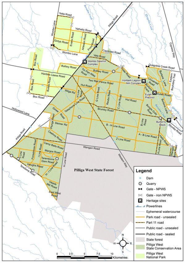
Pilliga Outwash Parks Statement of Management Intent

About this document
This statement of management intent outlines the main values, issues, management directions
and priorities of the National Parks and Wildlife Service (NPWS) for managing Pilliga National
Park, Pilliga State Conservation Area, Pilliga West National Park, Pilliga West State
Conservation Area and Merriwindi State Conservation Area. These parks are referred to
collectively in this statement as ‘the Pilliga Outwash parks’ or ‘the parks’.
This statement, together with relevant NPWS policies, will guide the management of the parks
until a plan of management has been prepared in accordance with the National Parks and
Wildlife Act 1974. The NPWS Managing Parks Prior to a Plan of Management Policy states
that parks and reserves without a plan of management are to be managed in a manner
consistent with the intent of the National Parks and Wildlife Act and the ‘precautionary
principle’ (see Principle 15).
A plan of management will be prepared to set out the ongoing management objectives for the
parks. The plan of management is a statutory document under the National Parks and Wildlife
Act which will be available for public comment. NPWS will also encourage the community to
contribute to the ongoing conservation of the parks by promoting and raising public awareness
of their special values. The legislative and policy framework for plans of management is
outlined in Appendix A.
Scientific names for common names mentioned in the text (as well as the status) are included
in Appendix B.
This statement of management intent was approved by the Director, Northern Inland on
10 November 2017.

Acknowledgments
NPWS acknowledges the Pilliga Outwash parks are in the traditional Country of the Gamilaroi
People (also known as the Gomeroi and Gamilaraay People).
This document was prepared by staff of NPWS, part of the Office of Environment and
Heritage.

Contacting NPWS
For more information or any inquiries about this statement of management intent or the Pilliga
Outwash parks, contact the NPWS Office at 50–58 Wellington Street, Baradine NSW 2396; by
mail to PO Box 105, Baradine NSW 2396; or by telephone (02) 6843 4000.

                                                 iii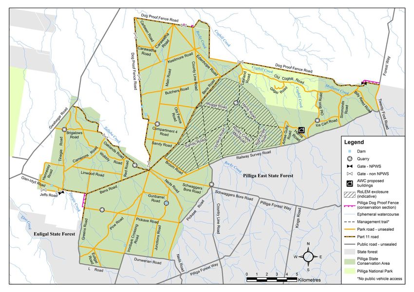
Pilliga Outwash Parks Statement of Management Intent

                                                     Contents
1       Landscape setting and context .................................................................................. 1

2       Protecting the natural environment ........................................................................... 7
        2.1     Geology and landform .......................................................................................... 7
        2.2     Native plants ........................................................................................................ 9
        2.3     Fire..................................................................................................................... 17
        2.4     Native animals.................................................................................................... 20
        2.5     Pest animals ...................................................................................................... 27
        2.6     Climate change .................................................................................................. 30

3       Looking after our culture and heritage .................................................................... 33
        3.1     Aboriginal culture and heritage ........................................................................... 33
        3.2     Shared cultural heritage ..................................................................................... 35

4       Public use of the park ............................................................................................... 39
        4.1     Recreation.......................................................................................................... 39
        4.2     Firewood collection ............................................................................................ 40
        4.3     Illegal activities ................................................................................................... 40
        4.4     Research............................................................................................................ 40

5       NPWS infrastructure and services ........................................................................... 42
        5.1     Park roads and management trails ..................................................................... 42
        5.2     Water supply infrastructure ................................................................................ 42
        5.3     Quarries ............................................................................................................. 42
        5.4     Etoo radio tower and bore .................................................................................. 43
        5.5     Fencing and other infrastructure for the Reintroduction of Locally Extinct Mammals
                project ................................................................................................................ 43

6       Non-NPWS activities and infrastructure .................................................................. 45
        6.1     Apiary sites ........................................................................................................ 45
        6.2     Transmission lines and telecommunications ...................................................... 45
        6.3     Mining ................................................................................................................ 45

Appendices ......................................................................................................................... 47
        Appendix A           Legislation and policy ........................................................................... 47
        Appendix B           Scientific names ................................................................................... 50
        Appendix C           Vegetation communities in the Pilliga Outwash parks ........................... 55
        Appendix D           Vegetation management guidelines by community type for fire ............ 58

References .......................................................................................................................... 59

                                                                     iv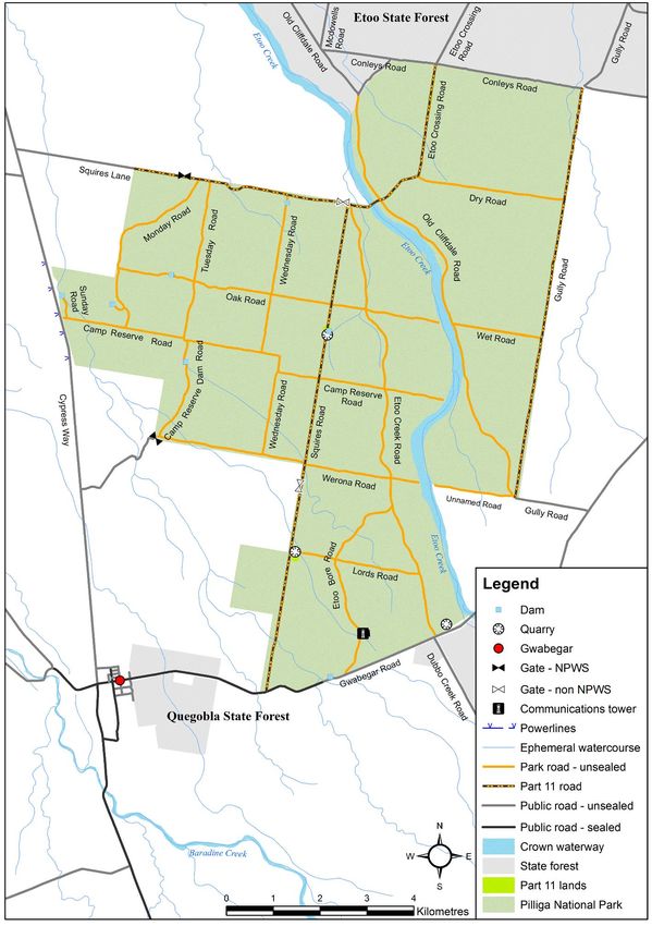
Pilliga Outwash Parks Statement of Management Intent

Tables
Table 1. The makeup of the Pilliga Outwash parks ................................................................. 1
Table 2. Vegetation communities occurring in the Pilliga Outwash parks.............................. 10
Table 3. Threatened ecological communities in the Pilliga Outwash parks ........................... 11
Table 4. Number and size of fires mapped on state forest and NPWS-managed lands in the
         Pilliga Outwash between 1950 and 2017 ................................................................ 18
Table 5. Pest animals recorded in the Pilliga Outwash ......................................................... 27
Table 6. New England North West climate change snapshot................................................ 31

Figures
Figure 1.     Overview of Pilliga Outwash parks ........................................................................ vi
Figure 2.     Pilliga north parks – Pilliga State Conservation Area and part Pilliga National Park
              (Gilgais).................................................................................................................. 3
Figure 3.     Part Pilliga National Park (Etoo) ............................................................................. 4
Figure 4.     Pilliga West State Conservation Area and Pilliga West National Park .................... 5
Figure 5.     Merriwindi State Conservation Area ....................................................................... 6

                                                                   v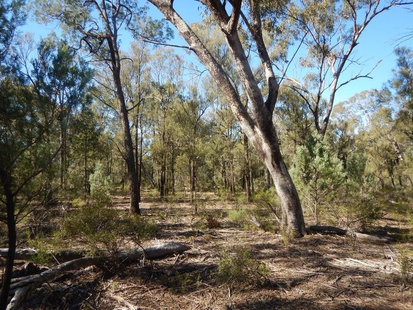
Pilliga Outwash Parks Statement of Management Intent

Figure 1. Overview of Pilliga Outwash parks

                                                                       vi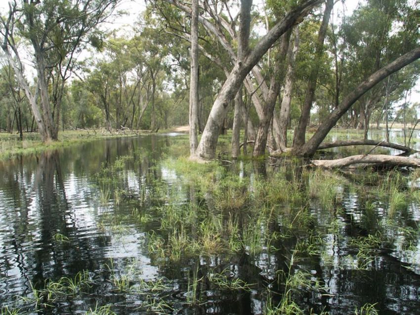
Pilliga Outwash Parks Statement of Management Intent

1          Landscape setting and context
    Objective: The Pilliga Outwash parks retain an important place in the network of
    vegetated, conserved land in the Brigalow Belt South Bioregion.

The Pilliga Outwash is a broad alluvial province on the western slopes of the Great Dividing
Range in northern inland New South Wales, 40 kilometres north of Baradine. It takes its name
from the series of intersecting alluvial fans formed by creeks draining towards the Namoi River
from the Pilliga Forest uplands in the south-east.
The Pilliga Outwash parks were gazetted in December 2005 as a result of the Brigalow Belt
South and Nandewar bioregional assessment process and consequent decision to create new
conservation reserves under the Brigalow and Nandewar Community Conservation Area Act
2005. Prior to 2005, the parks were state forests managed for the commercial production of
cypress pine and ironbark.
There are five parks within the Pilliga Outwash group. Together they form the north-west section
of the 500,000-hectare contiguous forest known as the Pilliga Forest (formerly known as the
Pilliga Scrub) which occurs between Pilliga, Narrabri and Coonabarabran (see Figure 1). This
expanse of forest is the largest surviving woodland remnant on the inland western slopes and is
a key area for biodiversity conservation in inland New South Wales. Part of the Pilliga Forest
continues to be managed for timber production within state forests. Land adjoining the Pilliga
Forest is mostly used for grazing and dryland cropping.
The parks in the Pilliga Outwash cover 91,171 hectares. The areas and former names of the
individual parks are shown in Table 1 and Figures 2 to 5. In this plan, ‘Pilliga West parks’ refers
to the parks west of Cypress Way; namely Pilliga West State Conservation Area, Pilliga West
National Park and Merriwindi State Conservation Area. ‘Pilliga North parks’ refers to Pilliga
National Park (Etoo and Gilgais sections) and Pilliga State Conservation Area.

Table 1.     The makeup of the Pilliga Outwash parks

 Park (gazetted name)                        Size (ha)       Previous name
 Pilliga National Park                         11,120        Gilgai Flora Reserve (Pilliga East State Forest)
 (Pilliga Community Conservation Area                        Etoo State Forest
 Zone 1 National Park)                                       Quegobla State Forest
 Pilliga State Conservation Area               33,386        Cubbo State Forest
 (Pilliga Community Conservation Area                        Euligal State Forest
 Zone 3 State Conservation Area)                             Pilliga East State Forest
 Pilliga West National Park                      8,040       Pilliga West State Forest
 (Pilliga West Community Conservation
 Area Zone 1 National Park)
 Pilliga West State Conservation Area          36,895        Pilliga West State Forest
 (Pilliga West Community Conservation
 Area Zone 3 State Conservation Area)
 Merriwindi State Conservation Area              1,730       Merriwindi State Forest
 (Merriwindi Community Conservation
 Area Zone 3 State Conservation Area)

The area subject to this statement of management intent also includes lands that are vested in
the Minister administering the National Parks and Wildlife Act 1974. These lands are referred to

                                                         1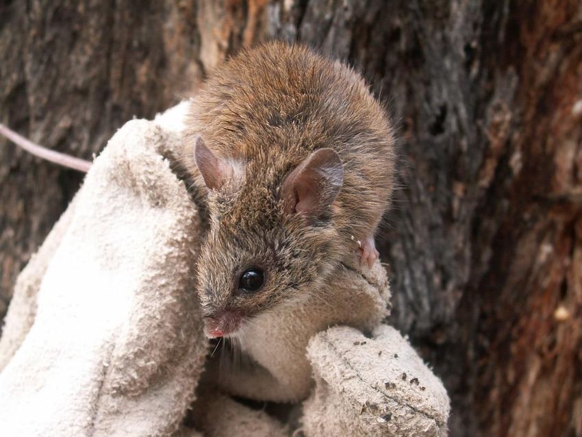
Pilliga Outwash Parks Statement of Management Intent

as Part 11 land and allow for continued access by private landowners through the park(s) to
their land.

Some patches of Crown land occur in the Pilliga Outwash parks which are currently being
managed as if they were included in the gazetted area of the parks. The most notable of these
is the bed of Etoo Creek in the Pilliga National Park Etoo section (Figure 3). The bed of this
creek contains high quality koala habitat and is in a strategic location for control of some pest
species.
The Pilliga Outwash is almost entirely within the Brigalow Belt South Bioregion (Thackway &
Cresswell 1995). Less than 1% on the south-west edge of Pilliga West State Conservation Area
is within the Darling Riverine Plains Bioregion. The soils in the Brigalow Belt South Bioregion
are relatively fertile and an estimated 80% of the bioregion has either been extensively cleared
of native vegetation or substantially modified. The level of conservation in the bioregion is 8.7%
and other than the Pilliga Forest, remnant vegetation is heavily fragmented, occurring on land
found to be unsuitable for agriculture. To the south-east of the Pilliga Outwash parks are the
Pilliga East parks: Timmallallie National Park, Pilliga East State Conservation Area and Pilliga
Nature Reserve. Warrumbungle National Park is located to the south. These parks are
addressed in separate statements of management intent and plans of management.
Climate in the Pilliga Outwash is temperate with a summer-dominant rainfall pattern and
moderately dry winters. Mean annual rainfall is between 600 and 750 millimetres (Murphy
2013). Mean monthly temperatures range from 2°C to 33°C but maximum temperatures can
reach the high 30s.
Several authorities operate within the area occupied by the Pilliga Outwash parks including:
      •    Baradine, Coonamble, Narrabri, Pilliga, Walgett and Wee Waa local Aboriginal land
           councils
      •    North West and Central West local land services
      •    Coonamble, Narrabri, Walgett and Warrumbungle shire councils.

Management directions
1a)       Management activities will focus on the conservation of biodiversity and heritage values.
1b)       NPWS will work cooperatively with neighbouring landholders, Forestry Corporation of
          NSW, shire councils, Local Land Services, local Aboriginal land councils and other
          stakeholders in managing the Pilliga Outwash parks.
1c)       NPWS will continue to manage the values of the Crown land parcels.

                                                      2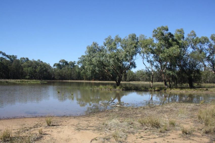
Pilliga Outwash Parks Statement of Management Intent

Figure 2. Pilliga North parks – Pilliga State Conservation Area and Pilliga National Park (Gilgais section)

                                                                       3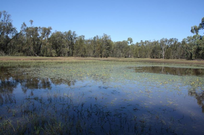
Pilliga Outwash Parks Statement of Management Intent

Figure 3. Pilliga North parks – Pilliga National Park (Etoo section)

                                                 4
Pilliga Outwash Parks Statement of Management Intent
Figure 4. Pilliga West parks – Pilliga West State Conservation Area and Pilliga West
National Park
5Pilliga Outwash Parks Statement of Management Intent
Figure 5. Pilliga West parks – Merriwindi State Conservation Area
6Pilliga Outwash Parks Statement of Management Intent
2 Protecting the natural environment
2.1 Geology and landform
Objective: Sensitive landscape features such as the gilgais and ephemeral
wetlands are managed to avoid erosion and promote long-term protection
The geology of the Pilliga Outwash comprises predominantly coarse-grained sediments of the
Great Artesian Basin and Surat Basin which were laid down during the Triassic and Jurassic
periods (225–136 million years ago). In the Miocene epoch (23–5 million years ago) the area
experienced igneous activity and subsequent movements of the earth’s crust, which after a
long period of weathering resulted in the Nandewar, Liverpool and Warrumbungle ranges.
However, the landscape of the Pilliga Outwash is the relatively flat base of a series of
intersecting alluvial fans, formed in the Cainozoic era (65 million years ago to the present) as
creeks drained northwards toward the Namoi River. The sedimentary deposits of the Pilliga
Outwash are the quartz sandstones and mudstones of the Purlawaugh Beds dating from the
lower and middle Jurassic period, and the quartz Pilliga Sandstones of the upper Jurassic
period (NPWS 2000). Sediments are coarser towards the apex of the main alluvial fan (at the
southernmost point of the Pilliga Forest) and finer clays occur towards the base in the Pilliga
Outwash (Murphy & Shea 2013).
Gilgais and sand monkeys
Gilgai is a term used throughout central and western New South Wales and Queensland for the
shallow, natural depressions which form in cracking clay soils under brigalow woodland, as the
result of distinctive morphological processes, and which occasionally fill with water after rain.
‘Gilgai’ has been incorrectly applied to the ephemeral wetlands in the Pilliga Outwash which have
formed from predominantly sandplain geology and are thought to have originated from former
billabongs or ponds left over from ancient drainage lines (Bell et al. 2012). This term is, however,
still used to refer to these relatively rare, localised wetlands in the Pilliga Outwash landscape.
Old Boo, the largest ephemeral wetland in Pilliga National Park, after recent rain. Photo credit: P Berney, OEH
7Pilliga Outwash Parks Statement of Management Intent
A unique assemblage of plants and animals is associated with these wetlands in Pilliga National
Park, recently recognised as the Pilliga Outwash Ephemeral Wetlands in the Brigalow Belt South
Bioregion Endangered Ecological Community (see Section 2.2.2).
Sand monkey is a local term which refers to sand-filled palaeochannels or abandoned stream beds
in the Pilliga Outwash landscape. Unlike palaeochannels which retain a concave shape and hold
water, sand monkeys are convex at the surface. The channels are filled with deep medium sand,
either yellow or red, depending on the drainage (DEC 2006).
Schematic cross section showing the landscape position and comparative age of sand monkeys in the Pilliga forest
area. (Ka = kilo annum meaning thousand years). Source: from DMR 2002, as modified after Hesse 2000.
The soils in the Pilliga Outwash are typically soft sandy soils dominated by deep solodic soils
with sandy to loamy top soils. These earthy and siliceous sands are hard setting, and the clays
(grey, brown and red) found at the northern end of the Outwash are saline and often highly
sodic (Namoi CMA 2009). Patches of quicksand occur in outwashes sometimes long after
surface water has disappeared.
There are a number of major catchments within the Pilliga Outwash which all drain to the
Namoi River. The main creek lines contained within these catchments include Baradine Creek,
Quegobla Creek, Etoo Creek, Talluba Creek and Coghill Creek. These creeks are ephemeral
in character and there is no permanent surface water in the Pilliga Outwash parks. Creek
crossings on park roads are vulnerable to erosion.
Management directions
2a) Gilgais and other sensitive landscape features are protected and managed to avoid
adverse impacts. This may require preventing access by vehicles and other measures.
2b) Creek crossings and other areas of potential or active erosion are monitored and
stabilised as required.
8Pilliga Outwash Parks Statement of Management Intent
2.2 Native plants
Objective: The structural and habitat diversity of vegetation communities is
maintained
Objective: Native plant communities are protected and where necessary
restored
Objective: Understanding of the ecology, distribution, threats and
management needs of native plant communities is added to and applied in
the parks
Objective: Negative impacts on threatened plant species are minimised
2.2.1 Native vegetation communities
The Pilliga Outwash parks are part of a larger Pilliga park system which conserves significant
examples of the largest intact native forest west of the Great Dividing Range. The majority of
native vegetation on more productive clay and loam soils in the surrounding area has been
cleared for agriculture, and the forest that remains is a large dry woodland remnant on the
poorest sandy soils (Murphy 2013).
The Pilliga Outwash parks are important for protecting a representative sample of the flora and
fauna of the Brigalow Belt South Bioregion. The Brigalow Belt South Bioregion covers a large
climatic range longitudinally (i.e. from north to south), and lies within an ecological gradient or
ecotone between the dry, inland bioregions (or Eyrean zone) and wetter coastal bioregions (or
Bassian zone). Consequently, the area is environmentally diverse and rich in biodiversity
(NPWS 2000). This is clearly evident in the Pilliga Outwash parks in which 599 plant species
from 82 families have been recorded.
The vegetation of the Pilliga today comprises a mosaic of cypress pine, box and ironbark open
forests and woodlands, and is believed to represent about half of the original extent of the
Pilliga forests (Norris et al. 1991 and Norris 1996, both cited in Porteners 2007).
Buloke – White Cypress Pine – Ironbark Woodland, Pilliga State Conservation Area. Photo credit: M Billington,
OEH
9Pilliga Outwash Parks Statement of Management Intent
The Pilliga Outwash forests comprise open eucalypt forest up to 25 metres tall on the more
fertile areas. The generally open eucalypt canopy is interspersed with an open subcanopy of
pines, casuarinas and wattles. Below this is an open sclerophyll shrub layer dominated by
legumes and a grassy semi-continuous ground cover.
The vegetation of the Pilliga Outwash parks has been described in two main vegetation
studies:
• the Pilliga North parks – Pilliga National Park and Pilliga State Conservation Area
(Hunter 2010) to the north
• the Pilliga West parks – Pilliga West State Conservation Area, Pilliga West National
Park and Merriwindi State Conservation Area (Porteners 2007).
These studies identified 12 vegetation communities occurring in the parks (see Table 2). The
key species, ecological setting, vegetation class and vegetation formation for these
communities are outlined in Appendix C.
Table 2. Vegetation communities occurring in the Pilliga Outwash parks
Community name Pilliga North Pilliga West
(from largest area to smallest area) parks parks
Buloke – White Cypress Pine – Narrow-leaved Ironbark Woodland ✓
Poplar Box – White Cypress Pine Woodland ✓ ✓
Pilliga Box – White Cypress Pine Open Forest to Woodland ✓ ✓
Narrow-leaved Ironbark – White Cypress Pine – Buloke Tall Open ✓
Forest
Dirty Gum (Baradine Gum) – White Cypress Pine Tall Woodland ✓ ✓
Derived Speargrass – Wallaby Grass – Wire Grass Mixed Forb ✓ ✓
Grassland
Blakelys Red Gum x Dirty Gum – White Cypress Pine Tall Riparian ✓ ✓
Woodland
Fringe Myrtle Shrubland ✓
Belah Woodland on Alluvial Plains ✓ ✓
Red Ironbark – White Bloodwood +/- Burrows Wattle Heathy ✓
Woodland
Broom Bush – Wattle Very Tall Shrubland ✓
Pilliga ‘tank gilgai’ Wetland Sedgeland Rushland ✓
In the Pilliga West parks (i.e. Pilliga West National Park, Pilliga West State Conservation Area
and Merriwindi State Conservation Area), the dominant canopy tree species are narrow-leafed
ironbark, poplar box (known locally as bimble box) and Pilliga box. Overall, the poplar box
woodlands are characterised by older growth structure than the ironbark woodlands which
were more intensively harvested for timber and show a higher degree of disturbance with
fewer old-growth areas and less hollow development (Porteners 2007). The three main
communities which together make up approximately 50% of the Pilliga West parks are:
• Poplar Box – White Cypress Pine Woodland
• Narrow-leaved Ironbark – White Cypress Pine – Buloke Tall Open Forest
• Pilliga Box – White Cypress Pine – Buloke Shrubby Woodland.
10Pilliga Outwash Parks Statement of Management Intent
In the Pilliga North parks (i.e. Pilliga National Park and Pilliga State Conservation Area), 11
vegetation communities are recorded (see Table 2). Buloke – White Cypress Pine Woodland
is by far the most dominant community, covering over a quarter of the total area.
Pilliga ‘tank gilgai’ Wetland Sedgeland Rushland is found only in the gilgai section of the north
Pilliga Outwash and is a listed threatened ecological community (see Table 3 and Box 2).
Riparian communities are uncommon in the Pilliga Outwash parks, being restricted to the few
sandy alluvial watercourses of ephemeral creeks. On sandier soils in watercourses and on the
sand monkeys, vegetation tends to show a high degree of disturbance and there is little or only
limited regeneration of primary tree species. This can be due to the combined effects of
grazing of the grassy ground cover by stock, goats and rabbits, and the susceptibility of these
soils to erosion. In addition, these communities usually have a high boundary length to area
ratio which make them prone to weed infestation and disturbance (Sivertsen & Metcalfe 1995,
cited in Hunter 2010).
Belah communities are also uncommon and occur in a series of small isolated patches and
some larger areas on slightly higher alluvial flats adjacent to major creek lines. Belah is
considered to be of conservation significance due to the high incidence of clearing and
disturbance by agricultural practices across its range (Hunter 2010).
The areas of Derived Speargrass Grassland in the Pilliga Outwash parks include cleared land
and areas which were heavily used by stock, in total, about 5200 hectares. These areas are
monitored for weed incursion and are expected to gradually regenerate naturally.
The Pilliga Forest was previously managed primarily for timber production. Some areas were
heavily selectively logged and occupational permits were available to nearby landowners for
grazing stock on the grassy ground layers. Past management practices have resulted in
extensive changes to forest and woodland structure and species composition.
2.2.2 Threatened communities and plants
Five threatened ecological communities (TECs) listed under the Biodiversity Conservation Act
2016 are known to occur in the parks (see Table 3), but their extent in the parks is not yet
known. Inland Grey Box Woodland and Brigalow are also listed nationally as threatened
ecological communities under the Environment Protection and Biodiversity Conservation Act
1999.
Table 3. Threatened ecological communities in the Pilliga Outwash parks
Common name, BC Act Description Threats
Carbeen Open Forest Open forest community which • Land clearing and
Community in the Darling may now only exist as woodlands fragmentation
Riverine Plains and or remnant trees. Characteristic • Weed invasion
Brigalow Belt South tree species are carbeen and
• Overgrazing
Bioregions EEC white cypress pine. Occurs on
riverine plains on siliceous, earthy • Drift of herbicides and
and clayey sands. pesticides
• Inappropriate fire regimes
Brigalow within the Low woodland or forest • Clearing, fragmentation and
Brigalow Belt South, community dominated by brigalow thinning for grazing and
Nandewar and Darling with pockets of belah and poplar cropping
Riverine Plains Bioregions box • Roadworks and road
EEC maintenance activities
(Brigalow [Acacia • Logging for fence posts
harpophylla dominant and
• Weed invasion
co-dominant] EEC under
the EPBC Act)
11Pilliga Outwash Parks Statement of Management Intent
Common name, BC Act Description Threats
• Predation of wildlife by foxes
and feral cats
Fuzzy Box Woodland on Tall woodland or open forest • Clearing of remaining
Alluvial Soils of the South dominated by fuzzy box often with remnants and isolated
Western Slopes, Darling inland grey box or kurrajong and paddock trees
Riverine Plains and buloke. Understorey species • Senescence and lack of
Brigalow Belt South include wilga, Deane’s wattle, hop regeneration
Bioregions EEC bush, cassia, water bush and
• Inappropriate fire regimes,
sifton bush.
primarily complete
suppression of fire
• Weed invasion
• Species diversity, composition
and structure will be impacted
by long-term climate change
Inland Grey Box Woodland Woodland community dominated • Small-scale clearing for
in the Riverina, NSW South by inland grey box in association cropping, pasture
Western Slopes, Cobar with poplar box, white cypress improvement
Peneplain, Nandewar and pine and buloke. Shrubs are • Grazing by stock and rabbits
Brigalow Belt South generally absent or sparse.
• Poor representation in
Bioregions EEC
isolated conservation
reserves
(Grey Box [Eucalyptus • Illegal firewood collection
macrocarpa] Grassy
• Inappropriate fire regimes
Woodlands and Derived
Native Grasslands of • Competition of native
South-Eastern Australia understorey with invasive
EEC under the EPBC Act) grasses and other weeds
Pilliga Outwash Ephemeral Wetlands associated with • Soil disturbance by feral pigs,
Wetlands in the Brigalow ephemeral creeks and waterways recreational vehicles, stray
Belt South Bioregion EEC but in an exceptionally restricted stock, feral goats and horses
geographic distribution. They are • Road and drain construction
formed on cracking clay, alluvial and consequent hydrological
soils. Species richness is change and/or sedimentation
extremely variable with the
wetland depth gradient. Generally
dominated by buloke, dirty gum,
Melaleuca densispicata and
mugga ironbark.
BC = Biodiversity Conservation Act; EPBC Act = Environment Protection and Biodiversity Conservation Act; EEC =
endangered ecological community. Source: OEH n.d., DoEE n.d.(a).
Pilliga Outwash Ephemeral Wetlands Endangered Ecological Community (NSW
SC 2015)
This community is extremely restricted, occurring as a chain of ponds each about 20 centimetres
deep and usually less than 1 hectare. It occupies a total area of only about 84 hectares in the gilgai
section of Pilliga National Park and approximately 0.5 hectares in Merriwindi State Conservation
Area. It was first identified as a distinct vegetation community in 2010 (Pilliga ‘tank gilgai’ Wetland
Sedgeland Rushland, Brigalow Belt South Bioregion by Benson et al. 2010).
In the Pilliga’s dry subtropical climate, the wetlands form only under particular climatic conditions
such as the large rainfall events in 2010 through to early 2011. The majority of these wetlands are
likely to fill once a decade at most, and the smallest of them dry up in a matter of weeks (Bell et al.
12Pilliga Outwash Parks Statement of Management Intent
2012). The larger wetlands fill more often and can retain water for months. Their ephemeral nature
make them an important component of habitat for visiting birds, including migratory species, in an
otherwise dry, sandy landscape (see Section 2.4).
Pilliga Outwash Ephemeral Wetlands community includes three threatened native herb species
listed under the Biodiversity Conservation Act: austral pipewort, winged peppercress and a
creeping matted herb called Myriophyllum implicatum. The community also includes six species
considered to be regionally significant since they are disjunct or thought to be at or near their
geographic limit.
Shallow ephemeral wetland, Pilliga National Park. Photo credit: P Berney, OEH
Recovery of threatened plant species
In addition to threatened ecological communities, the Pilliga Outwash parks are known to contain
19 threatened plant species (see list in Appendix B).
Strategies for the recovery of threatened species, populations and ecological communities have
been set out in a statewide Biodiversity Conservation Program (OEH 2017a) (formerly known as
the Threatened Species Priorities Action Statement). These actions are prioritised and
implemented through the Saving our Species program which aims to maximise the number of
threatened species that can be secured in the wild in New South Wales for 100 years (OEH
2013c).
Three of the threatened species occurring in the Pilliga Outwash parks are being managed under
targeted recovery strategies under the Saving our Species program.
Myriophyllum implicatum
This critically endangered plant species was previously thought to be extinct in New South Wales.
It was recently discovered in Pilliga National Park in a large, partly open, inundated gilgai
depression on cracking clay soil. Very little is known about the species’ distribution, especially on
private lands to the north. There is a high risk of extinction for this species due to the small
population size and restricted distribution.
The recovery strategy developed for Myriophyllum implicatum covers an area of 100 hectares and
includes a combination of protective measures, monitoring and establishment of a second
13Pilliga Outwash Parks Statement of Management Intent
population by translocation. Management activities proposed to protect the species in Pilliga
National Park are:
• pest control to reduce the density of feral pigs and maintain pig populations at low levels
• targeted surveys to identify additional populations
• increased staff surveillance and installation of barriers to prevent access by recreational users
if illegal activities continue.
Monitoring of the populations and threats will also be carried out to determine population trends
through time and assess the effectiveness of management actions.
Austral pipewort
This species grows in mud in ephemeral waterbodies and occurs in the northern section of Pilliga
National Park and the north-east section of Pilliga State Conservation Area. The recovery strategy
covers an area of 6794 hectares. Management actions include:
• targeted surveys to identify additional population(s)
• monitoring disturbance impacts to minimise impacts of recreational activities
• monitoring plant populations to track species abundance/condition over time.
Winged peppercress
This plant species is widespread in the semi-arid western plains regions of New South Wales but
also occurs in the Pilliga Outwash. It occurs on seasonally moist to waterlogged sites on heavy
fertile soils.
One of the key threats to this species in the Pilliga Outwash is disturbance by four-wheel drive
vehicles which churn up the ground surface and disturb their preferred habitat structure. The
recovery strategy occurs in the same location as the strategy for Austral pipewort and over an area
of 5209 hectares. Management actions in the strategy include:
• construction of barriers to reduce access by recreational users
• monitoring of disturbance impacts
• monitoring of the populations to track species abundance/condition over time.
Winged peppercress, Pilliga National Park. Photo credit: OEH
14Pilliga Outwash Parks Statement of Management Intent
Prasophyllum sp. Wybong
This terrestrial orchid is critically endangered under the Environment Protection and Biodiversity
Conservation Act but not listed at the state level. It is endemic to New South Wales, and known
from several sites in the Namoi catchment. It has been recorded in some parts of the Pilliga and is
predicted to occur in the Pilliga Outwash parks. The population at Wybong in the Upper Hunter
Valley is by far the largest.
No priority actions have been identified at present. In order to get a clearer understanding of the
extent of the distribution and size of the population, surveys should be undertaken in spring to
locate populations in suitable habitat, such as roadsides.
2.2.3 Restoring and maintaining native vegetation values in the parks
The vegetation of the Pilliga Outwash parks has been affected by past timber harvesting and
associated silvicultural practices, and previous grazing of cattle and sheep under occupational
permits. The effects of these disturbances on the native vegetation ecosystems include:
• concentrations of even-aged stands of trees
• changes in canopy species dominance
• creation of man-made clearings and snig tracks in the forest
• a loss of hollow-bearing trees.
Now that selective harvesting of some species and thinning to maximise growth of preferred
species has ceased, one of the notable characteristics of the Pilliga Forest is the increase in
stem density of dominant canopy species, including eucalypt, cypress and buloke (Whipp et al.
2012). As regeneration of native vegetation communities continues unaided in the
NPWS-managed parks, it is likely that some species will re-establish at a greater density than
others over time.
Grazing in the forest has also contributed to the introduction of pasture grasses and
environmental weeds. The Pilliga Outwash parks are also susceptible to weed incursions via
the many creek lines which dissect the alluvial plain. Scalded areas, roadsides and other
disturbed sites are favoured habitats for weeds. Weeds are also introduced and readily spread
through the parks during flood events. Pest animals are also a vector responsible for
spreading weeds.
The Biosecurity Act 2015 and regulations embed the principle of shared responsibility for
biosecurity risks (including weeds) between the government, community and industry. This
legislation applies to both public and privately owned land. A regional strategic weed
management plan prepared under the Biosecurity Act identifies those pest plants that are
being prioritised for management action, investment and compliance effort within the North
West Local Land Services region (North West LLS 2017). These priorities will be implemented
via relevant NPWS regional pest management strategies.
The invasive nature of environmental and state and regional priority weeds, their widespread
occurrence in the broader landscape and the fact they compete with native species, requires
their continued monitoring and management. NPWS prepares regional pest management
strategies which identify priority pest plant and animal species and control programs. These
include relevant actions listed in the Biodiversity Conservation Program, threat abatement
plans, and strategies such as the NSW Biodiversity Priorities for Widespread Weeds (NSW
DPI & OEH 2011) and the NSW Biosecurity Strategy 2013–2021 (DPI 2013).
The overriding objective of the pest management strategy (OEH 2013b) is to minimise adverse
impacts of introduced species on biodiversity and other park and community values while
complying with legislative responsibilities. Populations and the distribution of weeds are
monitored and appropriate treatment applied as required, such as herbicide application.
15Pilliga Outwash Parks Statement of Management Intent
Priority weed species identified in the regional pest management strategy for control in the
Pilliga Outwash parks include: tiger pear, prickly pear, tree pear (also known as velvety tree
pear), mother-of-millions, carrion flower, Noogoora burr, African boxthorn, and spiny burrgrass.
African boxthorn, tiger pear, prickly pear and other opuntioid species are identified as state
priority species under the Biosecurity Act. Mother-of-millions is identified as a regional priority
species under the North West Regional Strategic Weed Management Plan (North West LLS
2017). Control actions for priority weeds in the Pilliga Outwash parks are focused on areas
where the weed species threaten the values of a threatened ecological community.
Management directions
2c) Relevant actions in the Biodiversity Conservation Program for threatened plant species,
populations and communities will be implemented.
2d) Relevant recovery actions for threatened plant species recorded in the Pilliga Outwash
parks will be integrated into the Reintroduction of Locally Extinct Mammals project.
2e) Vegetation mapping of the Pilliga Outwash parks will be reviewed.
2f) Survey and mapping for threatened ecological communities will be undertaken and used
to inform park management.
2g) Weed management will be undertaken in accordance with legislative requirements and
the pest management strategies relevant to the parks.
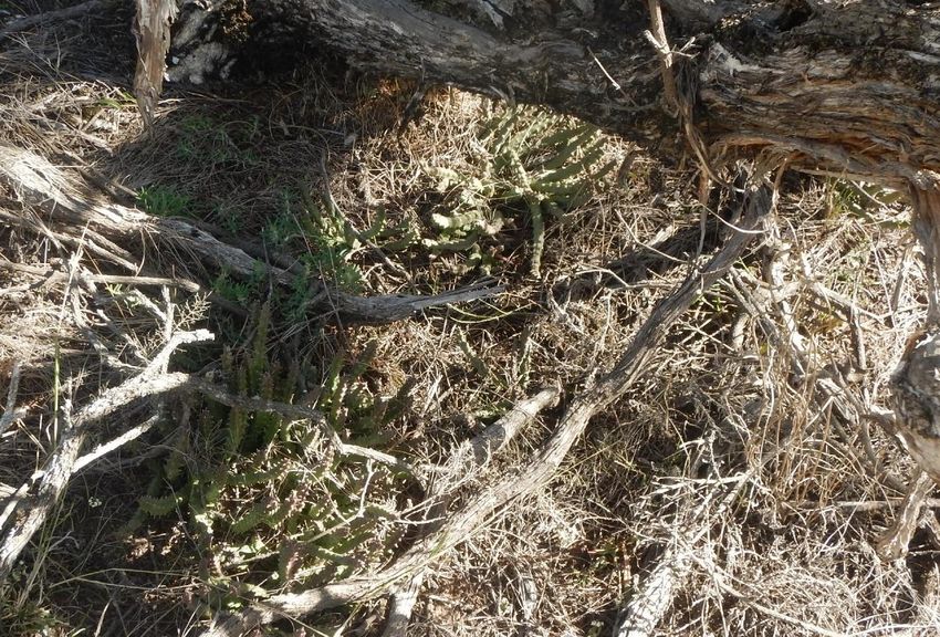
An unusual emerging weed
Carrion flower first appeared in the gilgai section of Pilliga National Park in 2013. This
succulent prostrate herb derives its name from the putrid stench of its striking purple and
cream star-shaped flowers which attracts flies that assist in pollination.
Carrion flower in Pilliga National Park. Photo credit: M Billington, OEH
Carrion flower is a declared weed in South Australia where it invades chenopod shrublands and is
associated with the decline and death of shrubs and ground layer herbs and grasses of arid
16Pilliga Outwash Parks Statement of Management Intent
regions (DEWNR 2015). In Pilliga National Park, carrion flower grows in the shelter of fallen timber.
A targeted eradication program is underway to ensure carrion flower does not proliferate and
adversely impact the values of the ephemeral wetlands endangered ecological community.
2.3 Fire
Objective: Fire in the parks is managed to conserve and maintain Pilliga
Outwash ecosystems while also protecting park management and other
infrastructure
Objective: The fire regimes applied in the parks maintain and promote the
conservation of biodiversity and other park values
Fire is an integral part of the Australian environment. It is a major factor in determining the
structure and species composition of vegetation, and has long-term effects on animal
populations. However, inappropriate fire regimes can lead to loss of particular plant and animal
species and communities, and high-frequency fires have been listed as a key threatening
process under the Biodiversity Conservation Act (NSW SC 2000c). The primary objectives of
NPWS’s fire management are to protect life, property and community assets from the adverse
impacts of fire, while managing fire regimes in parks to maintain and enhance biodiversity.
The Pilliga Outwash accounts for approximately one-third of the Pilliga Forest and is
dominated by white cypress pine and eucalypt woodlands. These woodlands have distinct fire
behavior, fire frequency and area burnt compared to the rest of the Pilliga Forest (Brookhouse
& Nicholson 1999). For example, the east and central areas of the Pilliga Forest are high fire
risk areas which experience frequent and large wildfires, but in most years the Pilliga Outwash
parks do not have sufficient fuel in the understorey to carry a fire, even in the shrubby grassy
communities. Fire risk in the Pilliga Forest follows a decreasing gradient from east to west as
the climate becomes more arid and the landscape becomes flatter.
Large-scale fire in the Pilliga Outwash is a rare event. Historically, large-scale wildfire has
occurred in this landscape following two consecutive years of above-average rainfall, during a
La Nin͂a cycle. These conditions promote extensive growth of ephemeral grasses, which
creates a continuous fuel load. Drying off of this grassy ground layer during the hot, dry
weather of a following El Nino cycle produces the optimal circumstances for wildfire, which is
usually ignited by a lightning strike.
2.3.1 Fire history in the parks
Aboriginal people are known to have used fire across the Australian continent to promote food
animals and other resources by deliberate burning of known habitats, sometimes at a small or
very small scale. Traditional fire management practices by Aboriginal people in the Pilliga
Outwash are unknown but it is likely that burning regimes were used to some extent to
encourage grazing areas, regenerate specific resources and keep corridors open for travel.
Accounts from the 19th century suggested that the Pilliga Forest underwent major structural
changes once the Gamilaroi People were displaced by Europeans. According to these
accounts, the forest was transformed from ‘clear and open’ forests (Oxley 1820, cited in Keith
2004) to ‘heavily and thickly timbered’ land some 50 years later (Battye 1887, cited in Keith
2004). These descriptions suggest there was an increase of woody vegetation and the forest
became shrubbier once regular burning was excluded. However, further critique of the early
explorer journals has found that conclusions about the nature of pre-European native
vegetation and the effect of Aboriginal-initiated fire management are selective and
inconclusive (Benson & Redpath 1997). It is also possible that other factors have contributed
to thickening of the vegetation. For example, there have been periods when above-average
17Pilliga Outwash Parks Statement of Management Intent
rainfall has coincided with effective suppression of rabbit activity resulting in a major
regeneration event, such as occurred from 1947 to 1950 (Keith 2004).
Over the last 100 years or so when the Pilliga Forest was managed as a series of unbroken
state forests, wildfire was actively suppressed in order to protect the commercial timber
resource. On the basis of available records, it appears that fire occurred reasonably frequently
but most fires were small. This fire regime has resulted in more uniform age classes in canopy
species such as cypress pine and ironbark and has likely constrained recruitment of species
that rely on fire for germination.
The fire history in the Pilliga Outwash is only partially known, with 60% of fires being ignited by
lightning strikes (Brookhouse & Nicholson 1999). In November 1951, a vast fire devastated
practically the whole of what was Pilliga East State Forest, now the area contained in Pilliga
National Park (Gilgais) and Pilliga State Conservation Area (Forestry Commission of NSW
1951). The burnt area was estimated to be 800,000 acres (323,749 hectares) of state forest
and 400,000 acres (161,874 hectares) private property. Since then, the largest fires in the
western part of the Outwash were in 1984 (1292 hectares) and 1977 (450 hectares). Today,
the majority of the Pilliga Outwash parks are long unburnt, and most of the West Pilliga has
not burned in the last 50 years (Porteners 2007).
Table 4. Number and size of fires mapped on state forest and NPWS-managed lands
in the Pilliga Outwash between 1950 and 2017
Area Burnt (ha) Number of firesPilliga Outwash Parks Statement of Management Intent
For the purpose of developing fire regimes, the 11 vegetation communities in the Pilliga
Outwash parks are grouped into 7 broad community types. The vegetation management
guidelines and expected fire behaviours for each of these community types are provided in
Appendix D.
The fire regimes adopted for the vegetation communities in the Pilliga Outwash parks reflect
the preferred fire intervals for plant communities and habitat requirements for animals where
these are known. Research into preferred fire intervals for individual species is a continuing
science. With increasing understanding about drier landscapes, NPWS is adopting longer,
more conservative fire intervals than those in moister, coastal areas. In the ephemeral
wetlands of the gilgai area (Pilliga National Park), fire should be completely excluded. The
shortest fire interval for vegetation in the Pilliga Outwash parks is presently 15 years (for
riparian/valley woodlands) and the current maximum fire interval is 30–50 years (for grassy
box woodlands). However, research suggests that longer intervals of up to 70 or 80 years may
be more appropriate for vegetation communities in the Pilliga Forest and it is likely that fire
intervals will be extended in the future.
2.3.3 Fire management strategies
Three fire management strategies which define NPWS’s approach to fire management have
been developed for the Pilliga Outwash parks:
• the Pilliga North strategy covers Pilliga National Park and Pilliga State Conservation
Area (OEH 2015b)
• the Pilliga West strategy covers Pilliga West National Park and Pilliga West State
Conservation Area (OEH 2015c)
• Merriwindi State Conservation Area has its own strategy (OEH 2015a).
These strategies outline the recent fire history of the Pilliga Outwash parks, key assets within
and adjoining the parks including built assets and sites of natural and cultural heritage value,
fire management zones and fire control advantages such as management trails and water
supply points. They also contain fire regime guidelines for conservation of the parks’
vegetation communities.
There are a number of vulnerable assets both on-park and adjoining the parks. Vulnerable
on-park assets include Aboriginal and historic heritage values such as scar trees, mill sites
and cottages; and infrastructure such as the Etoo radio tower and powerlines.
The following objectives identify the fire management intent for the fire management zones
identified in the Pilliga Outwash parks. The location of the zones will be reviewed and
amended in conjunction with development of the Reintroduction of Locally Extinct Mammals
project (see Box 6).
• Land management zones – almost the total area of the parks is presently managed as
a land management zone. The objective of this zone is to conserve biodiversity and
protect cultural and historic heritage. Fire in this zone is managed consistent with fire
thresholds.
• Strategic fire advantage zones – the objective is to provide strategic areas of fire
protection advantage which will reduce the speed and intensity of bushfires, and
reduce the potential for spot fires. These zones also help to contain bushfires to
existing management boundaries. The overall fuel hazard should be maintained in
these zones at high or below, however adherence to guidelines for biodiversity will take
precedence where practical.
• Asset protection zones – the objective of this zone is the protection of human life and
property, and highly valued public assets such as built infrastructure. In this zone,
these values take precedence over guidelines for the management of biodiversity.
Overall fuel hazard should be maintained at or below moderate.
19Pilliga Outwash Parks Statement of Management Intent
NPWS assists in developing fire management practices that contribute to conserving natural
and cultural heritage across the landscape, and implements cooperative and coordinated fire
management arrangements with other fire authorities, neighbours and the community (OEH
2013a).
NPWS maintains cooperative arrangements with surrounding landowners and the Rural Fire
Service and is a member of the Namoi, North-West and Castlereagh Zone bush fire
management committees.
Management directions
2h) Fire will be managed in accordance with the fire management strategies prepared for the
Pilliga Outwash parks. The overarching objectives of the fire management strategies are
to reduce the spread of wildfire across the landscape to prevent loss of life and property;
and to use fire as a management tool to enhance biodiversity values.
2i) Fire thresholds will continue to be reviewed to ensure they are appropriate for local,
fire-sensitive species and communities and incorporated into fire planning.
2.4 Native animals
Objective: Populations of all native animals are maintained
Objective: Populations of rare, threatened or regionally significant animal
species are protected and maintained
Objective: Regular survey and monitoring add to knowledge of the animals
and their habitats in the Pilliga Outwash parks
Objective: The Reintroduction of Locally Extinct Mammals project is
implemented in Pilliga State Conservation Area
2.4.1 Habitat for native animals
The Pilliga Outwash parks are part of the Pilliga Forest which is the largest area of continuous
native forest west of the Great Dividing Range and a significant wildlife refuge. Past
management practices have resulted in extensive changes to native vegetation structure and
species composition, but the Pilliga Forest continues to provide valuable habitat for
woodland-dependent and forest-dependent fauna.
In addition to the value of the contiguous Pilliga Forest at a landscape scale, the Pilliga
Outwash parks include important habitat features for native animals, such as:
• old-age canopy trees which contain cracks, spouts and hollows used by nesting birds,
bats and other arboreal mammals
• fallen timber, litter and coarse woody debris used by ground-dwelling mammals and
reptiles
• mixed-age forest that provides consecutive flowering and other resources for woodland
birds and arboreal mammals
• ephemeral wetlands which provide fleeting opportunities for aquatic communities in an
otherwise dry landscape.
To date, 260 native animal species have been recorded in the Pilliga Outwash parks, including
175 birds, 38 reptiles, 30 mammals and 17 amphibians. Of these, 31 are threatened species
listed under the Biodiversity Conservation Act or the Environment Protection and Biodiversity
Conservation Act (see Section 2.4.2). The invertebrate fauna of the Pilliga Outwash parks is
20Pilliga Outwash Parks Statement of Management Intent
even more diverse and includes several species found in no other parks in New South Wales,
including the sun moth (Murphy 2015) and the northern Australian mussel (Murphy & Shea
2013).
The Pilliga Outwash parks also support regionally significant species, including species at the
extremes of their range and migratory birds which opportunistically visit when ephemeral
wetlands form after occasional heavy rain events.
Nobbi, identified as a declining woodland reptile but widespread in the Pilliga Forest, at Merriwindi State
Conservation Area. Photo credit: M Murphy, OEH
Although the Pilliga Forest is between 290 and 420 kilometres inland from the east coast, its
wetlands have proven to be a valuable resource for shorebirds, such as happened following
the La Nina (wet) conditions of 2010 to 2011 (Murphy 2013). Over a period of almost 2 years,
seven species of shorebirds were recorded including four resident species, one migratory
species and two nomadic species. An additional two nomadic species are known from single
records. The Pilliga Forest has also been identified as an Important Bird Area, being
recognised as internationally important for bird conservation, particularly threatened woodland
birds (Dutson et al. 2009).
Aquatic systems in the Pilliga Outwash parks are within the Lowland Darling River Aquatic
Ecological Community which is listed under the Fisheries Management Act 1994 (FSC 2003).
There are many threatening processes affecting this community, including river regulation,
water extraction, clearing of riparian vegetation, stock access to riparian areas, removal of
instream timber debris, insecticide and fertiliser runoff from agriculture, and introduced
species. The high proportion of native woodland vegetation comprising stream catchments in
the Pilliga landscape is probably a major factor in the survival of a relatively intact example of
the fauna in this endangered community (Murphy & Shea 2013).
Over 100 years of logging has had extensive impacts on habitat and resources for native
animals in the Pilliga. Even in the parks now managed for conservation, the drier, less
productive and less predictable climate means that recovery is much slower than for the
forests of the east coast (NPWS 2000). Threats to native animals in the Pilliga Outwash parks
21You can also read