Assessing Ecosystem Service Benefits from Military Installations
←
→
Page content transcription
If your browser does not render page correctly, please read the page content below

Assessing Ecosystem Service Benefits from Military Installations

                                  Final Project Report
                          SERDP Project Number: RC18-1604

                                     Report prepared by:
    Oregon State University, Duke University and University of California at Santa Barbara
                                         July 26, 2019

Principal Investigator:
James Kagan, Institute for Natural Resources, Oregon State University

Project Participants and Contributors:
Mark Borsuk, Department of Civil and Environmental Engineering, Duke University
Ryan Calder, Department of Civil and Environmental Engineering, Duke University
Megan Creutzburg, Institute for Natural Resources, Oregon State University
Sara Mason, Nicholas Institute for Environmental Policy Solutions, Duke University
Lydia Olander, Nicholas Institute for Environmental Policy Solutions, Duke University
Andrew Plantinga, Bren School of Environmental Science & Management, University of
California Santa Barbara
Celine Robinson, Department of Civil and Environmental Engineering, Duke University

                                               i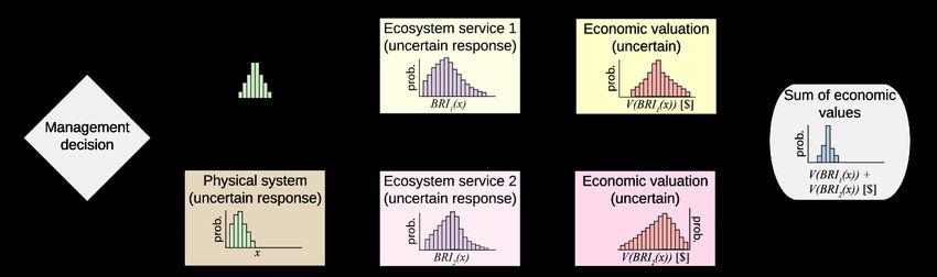
Form Approved
                       REPORT DOCUMENTATION PAGE                                                                                                                       OMB No. 0704-0188
Public reporting burden for this collection of information is estimated to average 1 hour per response, including the time for reviewing instructions, searching existing data sources, gathering and maintaining the data
needed, and completing and reviewing this collection of information. Send comments regarding this burden estimate or any other aspect of this collection of information, including suggestions for reducing this
burden to Department of Defense, Washington Headquarters Services, Directorate for Information Operations and Reports (0704-0188), 1215 Jefferson Davis Highway, Suite 1204, Arlington, VA 22202-4302.
Respondents should be aware that notwithstanding any other provision of law, no person shall be subject to any penalty for failing to comply with a collection of information if it does not display a currently valid
OMB control number. PLEASE DO NOT RETURN YOUR FORM TO THE ABOVE ADDRESS.
1. REPORT DATE (DD-MM-YYYY)                                          2. REPORT TYPE                                                                   3. DATES COVERED (From - To)
26-07-2019                                                           Final project report                                                              July 2018 – July 2019
4. TITLE AND SUBTITLE                                                                                                                                 5a. CONTRACT NUMBER

Assessing Ecosystem Services from Military Installations                                                                                              5b. GRANT NUMBER

                                                                                                                                                      5c. PROGRAM ELEMENT NUMBER

6. AUTHOR(S)                                                                                                                                          5d. PROJECT NUMBER
                                                                                                                                                      RC18-1604
James Kagan, Mark Borsuk, Ryan Calder, Megan Creutzburg, Sara Mason,                                                                                  5e. TASK NUMBER
Lydia Olander, Andrew Plantinga, Celine Robinson
                                                                                                                                                      5f. WORK UNIT NUMBER

7. PERFORMING ORGANIZATION NAME(S) AND ADDRESS(ES)                                                                                                    8. PERFORMING ORGANIZATION
                                                                                                                                                      REPORT NUMBER

Oregon State University                                                         1500 SW Jefferson Way Corvallis,
                                                                                OR 97331
Duke University                                                                 2138 Campus Drive
                                                                                Durham, NC 27708
UC Santa Barbara                                                                Santa Barbara, CA 93106
9. SPONSORING / MONITORING AGENCY NAME(S) AND ADDRESS(ES)                                                                                             10. SPONSOR/MONITOR’S ACRONYM(S)
Strategic Environmental Research and                                            4800 Mark Center Drive                                                SERDP
Development Program
                                                                                                                                                      11. SPONSOR/MONITOR’S REPORT
                                                                                                                                                          NUMBER(S)

12. DISTRIBUTION / AVAILABILITY STATEMENT
Approved for public release; distribution is unlimited

13. SUPPLEMENTARY NOTES

14. ABSTRACT
Military bases provide substantial ecosystem services to local communities and other members of the public. This project
conceptualizes and quantifies ecosystem services provided by U.S. military bases developing an integrated modeling
platform called MoTIVES (Model-based Tracking and Integrated Valuation of Ecosystem Services). MoTIVES manages
probabilistic simulations of biophysical and economic models for relevant ecosystem services provided by alternative base
management scenarios, and then assigns values where valuation is possible. The project demonstrated a proof of concept at
Eglin Air Force Base, showing that current management provides approximately $110 million in ecosystem services per
year, $40 million more than a scenario where no base was present, and $90 million more than a scenario where no base
management was occurring.
15. SUBJECT TERMS

16. SECURITY CLASSIFICATION OF:                                                                              17. LIMITATION                      18. NUMBER                19a. NAME OF RESPONSIBLE
                                                                                                             OF ABSTRACT                         OF PAGES                  PERSON
a. REPORT                           b. ABSTRACT                         c. THIS PAGE                                                                                       19b. TELEPHONE NUMBER
                                                                                                                                                                           (include area code)

                                                                                                                                                                              Standard Form 298 (Rev. 8-98)
                                                                                                                                                                                         Prescribed by ANSI Std. Z39.18

                                                                                                            ii
Contents
Abstract ...................................................................................................................................... v
Executive Summary .................................................................................................................... 1
1 Project Objectives ................................................................................................................ 1
2 Project Background.............................................................................................................. 1
3 Materials and Methods ......................................................................................................... 2
3.1 Overview of the Approach ............................................................................................ 2
3.2 Conceptual Models of Ecosystem Services ................................................................... 4
3.2.1 Generalized Habitat Conceptual Models ................................................................ 5
3.2.2 Base-Specific Conceptual Models .......................................................................... 7
3.3 Benefit Relevant Indicators (BRIs) and Economic Valuation ........................................ 9
3.4 Biophysical Models of Landscape Change .................................................................. 11
3.4.1 No-Base Scenario ................................................................................................ 11
3.4.2 Vegetation Condition Models .............................................................................. 12
3.5 Quantifying and Valuing Ecosystem Services ............................................................. 15
3.5.1 Wildfire Risk and Damage ................................................................................... 16
3.5.2 Respiratory Health ............................................................................................... 17
3.5.3 Timber Harvest .................................................................................................... 19
3.5.4 Renewable Energy Production ............................................................................. 20
3.5.5 Hunting and Fishing............................................................................................. 20
3.5.6 Recreation Opportunity ........................................................................................ 21
3.5.7 Carbon Storage .................................................................................................... 22
3.5.8 Listed, Endemic or Locally Important Species ..................................................... 23
3.5.9 Flood Damage and Risk ....................................................................................... 27
3.5.10 Water Available for Agriculture or Industry ......................................................... 29
3.5.11 Drinking Water Quality ....................................................................................... 30
3.5.12 Shoreline Erosion ................................................................................................ 32
3.5.13 Storm Surge Protection ........................................................................................ 33
3.6 Integrated Ecosystem Services Model ......................................................................... 34
4 Results and Discussion....................................................................................................... 36
4.1 Eglin Site Description ................................................................................................. 36
4.2 Scenarios Evaluated at Eglin ....................................................................................... 37
i4.3 Proof of Concept: Eglin Air Force Base Results .......................................................... 37
4.3.1 Vegetation Condition ........................................................................................... 37
4.3.2 Flood exposure and protection ............................................................................. 38
4.3.3 Monetized ecosystem services ............................................................................. 39
4.3.4 Habitat of critical species ..................................................................................... 41
4.3.5 Comparison of scenarios ...................................................................................... 42
5 Conclusions and Implications for Future Research and Implementation ............................. 43
5.1 Evaluation of the Approach......................................................................................... 43
5.2 Additional Research Needs to Improve This Approach ............................................... 44
5.3 Pilot Base Application ................................................................................................ 45
5.4 Feasibility Assessment of Future Expansion of this Work ........................................... 46
6 Literature Cited .................................................................................................................. 48
7 Appendices ........................................................................................................................ 52
7.1 Appendix 1. Generalized habitat conceptual models.................................................... 52
7.2 Appendix 2. Military base-specific conceptual models. ............................................... 60
7.3 Appendix 3. Methodology for Economic Valuation of Services at Eglin AFB ............. 64
List of Tables
Table 1. Potential benefit relevant indicators (BRIs) and economic values for ecosystem services provided
by military bases.
Table 2. Summary of potential approaches for benefit-relevant indicators and economic valuation for a
range of ecosystem services that may be provided at military bases.
Table 3. Species modeled as a function of vegetation condition in the STSM state classes, consisting of
vegetation age (early, mid, late), and structure (open and closed canopy).
Table 4. Modeled valuations of future flood risks by scenario.
Table 5. Monetized modeled ecosystem service values under three scenarios.
Table 6. Species habitat modeled ecosystem service values under three scenarios.
Table 7. Modeled net benefits of current management compared to counterfactual no-
management and no-base scenarios.
iiList of Figures
Figure 1. General structure of an ecosystem services conceptual model.
Figure 2. Schematic diagram of the major components of the MoTIVES integrated model for Eglin Air
Force Base.
Figure 3. Generalized habitat conceptual model for a fire-maintained forest type.
Figure 4. Military base-specific conceptual model for Eglin Air Force Base.
Figure 5. Conceptual diagram of the longleaf pine STSM used for Eglin Air Force Base.
Figure 6: The effects of cascading variability and uncertainty in integrated economic valuation of
ecosystem services associated with management decisions.
Figure 7: Map of Eglin Air Force Base and surrounding landmarks.
Figure 8. Projected longleaf pine forest condition classes at Eglin Air Force Base across the current
management, no management and no base scenarios in years 2031-2035.
Figure 9. Monetized ecosystem services.
Figure 10. Projected habitat area available for key species.
List of Acronyms
BRI: benefit-relevant indicator
CMECS: Coastal and Marine Ecosystem Classification System
CMAQ: Community Multiscale Air Quality
FEMA: Federal Emergency Management Agency
DEM: digital elevation model
DOD: Department of Defense
FNAI: Florida Natural Areas Inventory
LULC: land use and land cover
INRMP: Integrated Natural Resources Management Plan
InVEST: Integrated Valuation of Ecoystem Services and Tradeoffs
LiDAR: Light Detection and Ranging
MTBS: Monitoring Trends in Burn Severity
MoTIVES: Model-based Tracking and Integrated Valuation of Ecosystem Services
NOAA: National Oceanic and Atmospheric Administration
NWI: National Wetlands Inventory
iiiNVCS: National Vegetation Classification System
RCW: red-cockaded woodpecker
SERDP: Strategic Environmental Research and Development Program
STSM: state-and-transition simulation model
SWMM: Storm Water Management Model
USGS: United States Geological Survey
USFS: United States Forest Service
USFWS: United States Fish and Wildlife Service
Keywords
Bayesian modeling, Benefit-relevant indicators, Ecosystem services, Eglin Air Force Base,
Integrated modeling
Acknowledgements
Our team would like to acknowledge the major assistance we received from many people critical
to the successful completion of our project. In particular, Brett Williams, the Eglin Wildland
Support Module Lead provided access to data, information and valuable time and expertise
assuring that we understood as much as possible about the how Eglin is managed. Brett and
Bruce Hagedorn were both willing to help address all of our questions.
Equally important to the project success was the help provided by Dan Hipes and Jon Otting at
the Florida Natural Areas Inventory of Florida State University, who provided us with data,
helped with the analysis linking forest states to Eglin threatened and endangered species, and,
because of their expertise and experience with Eglin species, were able to help us solve many of
the complex questions that arise in a project involving multiple models.
At Fort Hood, we received data and guidance from Amber Dankert, Virginia Sanders, and David
Preston from the base, and Charlotte Reemts of The Nature Conservancy provided time and
information from her work at the base to help understand the relationship between habitats,
endangered birds and management at the base.
ivAbstract
Introduction and objectives: The United States military operates many military bases in
extremely diverse geographic contexts. Many of these bases feature large areas of land that
are undeveloped or sparsely developed in comparison to surroundings, providing a wide range of
important functions such as flood protection, habitat for plant and wildlife species, recreational
opportunities, and carbon sequestration. Therefore, military bases provide substantial ecosystem
services, primarily to residents and users of nearby land. This project develops methods to
conceptualize and quantify ecosystem services provided by U.S. military bases.
Technical approach: We developed conceptual ecosystem service models and related benefit-
relevant indicators to visualize and quantify the potential services provided by military bases. We
then developed an integrated modeling platform called MoTIVES (Model-based Tracking and
Integrated Valuation of Ecosystem Services) to quantify and evaluate ecosystem services
provided by alternative base management strategies. This platform manages probabilistic
simulations of biophysical and economic models for relevant ecosystem services. These
biophysical and economic models in turn leverage the latest scientific understanding of how
management influences environmental endpoints and, where possible, how these endpoints are
valued economically.
Results: This report presents conceptual ecosystem service models developed for a number of
habitat types and four military bases. We provide a proof of concept for MoTIVES by
quantifying ecosystem services at Eglin Air Force Base in Florida and outlining how this model
can be adapted to other sites. At Eglin, we simulated changes in carbon storage, species habitat,
flooding, timber harvest, and hunting/fishing across three scenarios: 1) continuation of current
management, 2) no natural resource management, and 3) no base.
Our simulations show that current natural resource management at Eglin provides important and
valuable services, particularly in providing flood protection and habitat for red-cockaded
woodpecker. The subset of services we modeled total over $110M in value each year. Net
benefits of the current management approach at Eglin is associated with net benefits that are
greater than alternative scenarios for land use: net benefits are $40M per year greater than a
hypothetical scenario in which the base does not exist and $90M per year greater than a scenario
in which base management activities are discontinued. In comparison with these alternative land-
use scenarios, current management practices provide more habitat area for 10 out of 12 other at-
risk species in the longleaf pine ecosystem (including all pond and beach species), which could
not be valued monetarily. Other services provided by Eglin, such as shoreline protection, were
not modeled for this pilot case study, but also provide value.
Benefits: MoTIVES provides relatable estimates of ecosystem service value for individual sites
that are readily understandable. We also demonstrate how use of an integrated modeling
framework improves confidence in overall valuations by tracking interrelated values and
uncertainties. Our approach is modular and easily transferable to very different contexts,
including military bases throughout the U.S. Finally, including uncertainties and complex
environmental phenomena enhances the realism and credibility of our valuations.
vExecutive Summary
Objectives
This project addresses the following three objectives from the SERDP Statement of Need:
1. Define and delineate the biological, physical and chemical services provided, including
natural and nature-based features that provide benefit.
2. Understand cumulative effects, feedbacks and compensatory behavior of complex
systems related to management of natural ecosystems and biological diversity.
3. Examine models that incorporate economic concepts and that may improve decision-
making to evaluate trade-offs.
To meet these objectives, we are developing an integrative ecosystem services model called
MoTIVES (Model-based Tracking and Integrated Valuation of Ecosystem Services) that
can be applied to any military base or DOD facility to estimate the impact of base management
on the provision of ecosystem services while accounting for interactions, offsets, and co-benefits
among services.
Approach
Ecosystem services are the benefits that nature provides to people. Often, the existence of
healthy natural systems and species is of sufficient importance to decision makers that no further
information is needed, but in many cases, it can be more impactful and informative to quantify
the specific benefits that nature is providing. To this end, we are developing the integrated
ecosystem services model MoTIVES so that it can be applied to any military base or DOD
facility at which natural resource management is being undertaken or considered. The model
encompasses a wide range of habitats and management activities and will produce an assessment
of a wide range of ecosystem services while accounting for interactions among habitats and
services. To date, we have developed methods for evaluating two scenarios relative to a
baseline of current management: (1) a no management scenario to assess how ecosystem
services would differ if the base did not conduct any natural resource management, and (2) a no
base scenario to assess how ecosystem service provision would differ if the base did not exist.
We developed and piloted our conceptual models at four bases: Eglin Air Force Base in Florida,
Fort Hood Army Base in Texas, Camp Lejeune Marine Base in North Carolina, and Joint Base
Lewis–McChord in Washington. We then applied this approach using more specific data and
relevant ecosystem services to Eglin Air Force Base, as an example of how it could be applied
elsewhere.
The development of our integrated ecosystem services modeling approach involved:
1. Creating a set of generalized ecosystem service conceptual models as the foundation for
a modeling framework that links management actions to ecosystem services while
identifying potential interactions,
2. Selecting and applying biophysical ecological models (terrestrial, aquatic, and flood
models) that characterize ecological state, condition, and function under the various
scenarios of interest,
13. Translating ecological state, condition, and function to benefit relevant indicators
(BRIs) of ecosystem service provision,
4. Estimating the economic value of the BRI levels whenever appropriate using approaches
including benefits transfer and direct estimation,
5. Joining the components above into the integrated ecosystem services model
(MoTIVES) to quantitatively and holistically account for cumulative effects, co-benefits,
feedbacks, and compensatory behavior.
Conceptual models
Ecosystem service conceptual models visually display how a base management action can
cause changes to biophysical aspects of an ecosystem and how these changes translate to benefit
relevant indicators and, when applicable, their economic values (Figure 1). Such conceptual
models form the basis of our subsequent quantitative modeling. Because there are common
habitat types that occur across DOD lands and there are often a defined set of management
actions being taken within these habitats, we determined that we could formulate a limited set of
generalized habitat conceptual models to be adapted and applied to any military base to then
create a base-specific model. These base-specific models are then used as the framework for
quantitative estimates of ecosystem services under specific base-relevant scenarios. Thus the
conceptual framework creates consistency in ecosystem service assessment across bases,
displaying how different elements of the system interact and providing a visual summary of the
relevant ecosystem services being quantified at each base.
Figure E1. General structure of an ecosystem services conceptual model. The actual conceptual models
include a detailed representation of each of the four stages shown here.
Generalized habitat conceptual models: Eight generalized habitat conceptual models
have been created to reflect common ecosystem service flows on military bases. These models
illustrate how management actions on bases result in changes to ecosystem services being
provided by specific terrestrial and aquatic habitat types that occur on bases all over the U.S.,
including: 1) fire-maintained forests, 2) forests not maintained by fire, 3) fire-maintained
grasslands, 4) grasslands not maintained by fire, 5) deserts, 6) rivers, streams, and riparian areas,
7) lakes, ponds, and wetlands, and 8) estuaries, saltmarsh, bays, and shorelines.
Base-specific conceptual models: Generalized habitat models are adapted and combined
to create base-specific conceptual models that reflect the ecosystem service changes resulting
from management at a particular base. Since the generalized models include potential ecosystem
service outcomes, some outcomes may not be applicable to a particular base of interest.
Therefore, to build a base-specific model, the user selects only the habitat models relevant for the
base and removes irrelevant components. Once each relevant habitat model has been adapted to
reflect the base-specific context, the resulting connected habitat models represent the integrative
conceptual modeling framework to be used to quantify the base total ecosystem service flows.
2Quantitative predictive model MoTIVES
Ecological models are used to represent the biophysical connections between management
actions and changes to ecosystem type, condition, function or extent. Following are the two
classes of ecological models being used:
Terrestrial Vegetation Condition Models: State-and-transition simulation models
(STSMs) describe the primary states of vegetation composition and structure, and how individual
states change over time under various disturbances (e.g., wildfire) or with management. We used
STSMs to project the effects of management actions such as prescribed burning and timber
harvest, disturbances such as wildfire and floods, and other processes on future vegetation
condition using the open source ST-Sim software. STSMs provide outputs describing the amount
of area occupied by each vegetation condition on a base under a set of management actions.
These area estimates can then be tied to certain ecosystem services that are dependent on
vegetation condition.
Aquatic Models: A series of models are available to model how management, wetlands,
riparian vegetation, streams and other water bodies, soils and other factors influence the type and
amount of aquatic ecosystem services provided by a base. These include flood risk and flood
amelioration, provision of water for drinking, livestock, irrigation or industrial use, and reduction
of sedimentation and nutrients, and habitat for valuable aquatic species. For this project we
included a flood risk model (HAZUS) to calculate the flood hazard, or the annual chance of
inundation at specific flood depths associated with inland flood risk as a function of local
elevation and land use characteristics. Flood events are valued economically within HAZUS
using data from the U.S. Census. In some cases, high resolution aquatic data sources specific to
military installations can be used to parameterize models or provide economic valuation for
services provided on the base.
Services were quantified using metrics referred to as benefit relevant indicators (BRIs). BRIs
are the hand-off between ecological function and social impact, connecting the supply of benefits
and the reception of those benefits by people. For example, water storage capacity of a wetland is
an ecological indicator, but the reduction in flooding risk to the downstream community resulting
from that wetland is a BRI. In some cases, these BRIs can be extended to a monetary value, but
in others monetary valuation is not possible or appropriate. When possible, we assign economic
valuation to these BRIs using literature or base-specific data.
For final evaluation, the various steps and components described above were joined into a single
integrated ecosystem services model called MoTIVES (Model-based Tracking and Integrated
Valuation of Ecosystem Services). This has the advantage over parallel assessment of individual
ecosystem services in that it allows for quantitative and holistic consideration of interactions,
including co-benefits and offsets. This is especially important when accounting for uncertainty or
potential site-to-site variability in assessment results. Changes in individual habitats and
ecosystem services may be positively or negatively related to one another at any particular base.
These relations may counterbalance one another, resulting in a smaller change than expected, or
may reinforce one another, resulting in a larger-than-expected change. Representing such
relations and interactions in an integrated model provides a more robust and realistic comparison
of ecosystem service differences between evaluated scenarios.
3Proof of Concept: Eglin Air Force Base
Eglin Air Force Base is the largest forested military base in the United States, supporting the
largest remaining mature longleaf pine (Pinus palustris) forest in the world, habitat for 24 listed
threatened or endangered species, and extensive freshwater and estuarine wetlands, ponds and
riparian meadows. The base has a number of coastal streams and bays that support at-risk fish,
along with desirable fishing locals. The base allows access for fishing and boating in all
appropriate areas. Much of the eastern portions of Santa Rosa Island, a Gulf of Mexico barrier
island, is part of Eglin, supporting turtle nesting, habitat for endangered shorebirds and a sand
adapted threatened lichen, along with providing protection from storm surges and coastal
flooding to the communities of Fort Walton Beach and Navarre. The base supports recreation,
hunting, and fishing, while providing the necessary infrastructure for its primary training
mission.
We used the MoTIVES model to evaluate three scenarios for Eglin Air Force Base:
• Current management scenario: The baseline scenario of current management assumes
that current natural resource management on the base would continue at current rates,
primarily consisting of widespread use of prescribed burning to create the open
conditions favorable to longleaf pine and associated wildlife species.
• No-management scenario: In this scenario, we assumed that the base continued all
military operations but did not (currently or historically) manage for natural resources,
with no prescribed fire or other management activity specific to natural resources.
• No-base scenario: To assess the total ecosystem services being provided by the base, we
created a counterfactual scenario in which the base does not exist, and based projections
on land use and land cover consistent with surrounding areas.
Annualized results from these scenarios were calculated for the future time period of 2020-2035.
Results for these analysis were reported for 1) vegetation condition, 2) flood exposure and
protection, 3) summarized for all monetized ecosystem services and 4) for habitat for at risk
species.
1: Vegetation condition. Currently, late open conditions cover roughly half of the forested area
at Eglin (roughly 77,000 ha). Under the current management scenario (consisting of continuing
large-scale prescribed burning), the area of late open forest is expected to increase to
roughly 115,000 hectares, covering the majority of the base (Figure E2). Conversely,
under the no management scenario (without any prescribed burning either currently or
historically), the base would likely contain very little (Figure E2. Projected longleaf pine forest condition classes at Eglin Air Force Base across the current
management, no management and no base scenarios in years 2031-2035. Without active management of
longleaf pine through prescribed fire under the current management scenario, condition degrades from
open (desirable) to closed (undesirable) canopy conditions.
2: Flood exposure and protection. Under current management, expected losses from flood
events over the period 2020–2035 average $610.4 million per year for the three counties
surrounding Eglin Air Force Base. Under no-management and no-base scenarios, these losses are
expected to be $579.8 million per year and $637.3 million per year respectively. However,
increased density of all trees under the no-management scenario means that this counterfactual
scenario would be associated with flood risks roughly $31 million per year lower than with
current management conditions.
Table E1. Modeled valuations of future flood risks (damages) by scenario over period 2020–2035. Values
displayed are means (95% CI)
Units Current management No management No base
610.4 579.8 637.3
M$/yr (b)
(251.7–1,689.2) (239.1–1,604.7) (262.8–1,763.6)
3: Monetized ecosystem services. Current management practices generate ecosystem service
benefits that are most often greater than the benefits associated with counterfactual no-base and
no-management scenarios. However there are trade-offs: flood risk may be lower with no base;
timber harvest would likely be greater with no base; and above-ground carbon storage is greatest
with a base that is not managed for natural resources.
Annualized results from these scenarios are presented for the future time period of 2020-2035.
They include very high flood hazard reduction values, with no management preventing ~ $31
5million in flood damage than current management, and ~$57 million more than a no base
scenario. Because these represent risk probabilities, they were treated separately. All other
services that could be valued in dollars were compared, with the results shown in Figure E2.
Table E2. Modeled ecosystem service values under three scenarios. Values displayed are means (95%
confidence interval in parentheses where modeled probabilistically)
Current
No management No base
management
Monetized services in millions of dollars/year(a)
39
Timber harvest 1.0 0
(24–48)
Recreational hunting 36 0 0
Recreational fishing 11 0 0
1.6 3.1 1.2
Carbon storage
(0.7–3.5) (1.4–6.7) (0.6–2.6)
Red-cockaded 56 30 11
woodpecker value (35–70) (18–36) (6.8–14)
Total monetized 109 33 51.2
services(b) (87–123) (20–40) (32–63)
(a)
Annualized net present value over period 2020–2035 assuming a 5% discount rate
(b)
Total adjusts for correlated uncertainties and may not equal arithmetic sum of individual services
4: Habitat of critical species. Eglin Air Force Base is home to a number of threatened,
endangered, and endemic species, many of which rely almost entirely on the base for their
survival. Thirteen of these species were modeled under the three scenarios as part of this study.
Current management practices produce the greatest area of suitable habitat for most of these
species, including sufficient amounts to preclude federal listing for a number of them. The
exceptions were the Gulf Coast redflower pitcherplant and smallflowered meadowbeauty. For
these two species, the no-management scenario provides slightly more area of suitable habitat.
The no-base scenario severely reduces available habitat for all species. Figure E3 shows the
comparison between the predicted species habitat areas.
6Figure E3. Habitat area available for key species under the three scenarios. Values plotted are based on
projected distribution of vegetation in the period 2031–2035. Error bars are the 95% confidence interval.
5. Comparison of scenarios. Current management practices are associated with higher
ecosystem service generation and lower value of flood risks than the no-base counterfactual.
Conversely, the no-management counterfactual is associated with lower ecosystem service
generation but also lower flood risks than current management. Taking account of these expected
costs and benefits across scenarios, we find that the current management practices scenario
produces significantly higher net benefits than either of the two counterfactuals (mean of $90.8
million and $40.5 million per year relative to no-management and no-base respectively)(Table
E3).
7Table E3. Modeled net benefits of current management compared to counterfactual no-management and
no-base scenarios. Values displayed are means (95% CI)
Current management service provision improvement over
Units No management No base
(a) 90.8 40.5
M$/yr
(66.5–127.1) (9.2–69.6)
(a)
Annualized net present value over period 2020–2035 assuming a 5% discount rate and accounting for correlated
uncertainties across individual services
Recommendations for Additional Research Needs
Aquatic ecosystem services. Because the most important services provided by Eglin Air Force
Base were linked to the management of terrestrial ecosystems, in our pilot study we were not
able to take advantage of some of the models and tools related to aquatic ecosystem services. At
other bases, where aquatic systems and services are important, other models should be
incorporated. The InVEST models have been tested and are simple to apply in many areas.
Water quality improvements. Similarly, research into water quality improvement related to both
the ecosystem processes of nutrient removal, and the value of removed N and P for anything but
waste water treatment would improve our model outputs.
Research into valuing species existence. Tradeoffs are most easily evaluated if different services
can be measured in similar units, which is why economic valuation is so useful. Yet many base
management activities on the pilot bases are focused on management of threatened, endangered
or endemic species, as they provide critical habitat for them. The conservation or expansion of
populations of at risk species represent important management outcomes.
More comprehensive assessment of economic values. We estimated economic values for many
BRIs, but future research is needed to provide a more comprehensive assessment. Economic
values for market goods are readily estimated because these goods have observable prices. For
example, we computed economic values for timber and flood damage using market data on
stumpage and real estate prices. Valuation of non-market goods is also possible using techniques
such as the contingent valuation method. Non-market benefits quantified for Eglin include
species preservation and carbon storage.
Conclusions
Since ecosystem services have become widely recognized as a useful tool for assessing the
success of natural resource management actions, quantifying and reporting on these services is
becoming part of good resource management practice. Our approach can help DOD natural
resource managers show how they are enhancing the production of services, and how the
existence of the base itself provides substantial ecosystem services benefits to people.
Our approach is unique in a number of ways. First, we use conceptual models as an intuitive
transferable foundation for building base specific models across habitat types and management
strategies. Second, we develop an assemblage of multiple models in an interactive probabilistic
platform that can address trade-offs and interactions. Third, we explicitly use benefit relevant
indicators (BRIs) as an alternative or additional measure to economic valuation.
8Due to its modular framework, we have been able to take advantage of previous ecological
assessment work available at many bases, but also have methods that apply where previous
ecological modeling has not occurred. We have identified national models and datasets available
for the contiguous 48 states. To use the approach in other regions, additional data and models
would need to be identified. The methodology can be readily transferred to any large base
anticipated to generate ecosystem services.
Ecosystem service outputs in the model are estimated in dollar values when possible, and also in
valued benefits (benefit relevant indicators). Often benefit relevant indicators are more
meaningful for stakeholders and are useful to communicate in addition to dollar values when
both are available. Because most bases provide a diverse array of ecosystem services, and
because some management decisions can reduce some services while increasing others, our
methods combine this complex assemblage into a single, Bayesian model (MoTIVES) to
integrate outputs and allow an evaluation of alternative management scenarios. This makes it
possible for natural resource managers to evaluate how management for a particular habitat
condition to support species or training will impact values for other services. Additionally, these
management scenarios allow a comparison of different management choices as well as providing
essential baseline comparisons needed to measure some ecosystem services such as flooding
prevention.
The MoTIVES structure also allows it to take advantage of a broad array of available ecosystem
assessment tools, broadening the ability to use the best data or model available for a particular
base. A distinguishing feature of MoTIVES is the fact that it explicitly considers uncertainty in
all aspects of the model and translates this uncertainty to model endpoints using Monte Carlo
simulation. By using simulation to explore the range of possible consequences of management
on ecosystem service values, we decrease the likelihood of later surprises or missed
opportunities. This approach makes conclusions robust to questions about confidence in
numerical answers. For example, despite wide confidence intervals, we are able to say with
>95% confidence that net benefits of current management practices at Eglin Air Force Base are
greater under current management than under plausible alternative scenarios considered.
The results from Eglin Air Force base show that current management provides very significant
ecosystem service values, estimated at approximately $110 million dollars a year, much more
than the same base not managed, or the same area if it had not become a base. It appears likely
that similar results would result from this analysis at Fort Hood and most of the other large
military installations.
91 Project Objectives
The objectives of this research are:
1. To develop a model that will provide a transferable and consistent foundation for
assessing ecosystem service benefits from military installations including an
understanding of cumulative effects, trade-offs, and uncertainty, and;
2. To provide a proof of concept for this model in an example military installation.
General conceptual models were developed for selected pilot inland and coastal bases that
addressed all ongoing management activities, including training requirements, land stewardship,
legal drivers, and coordination within and beyond installation boundaries. We explored how
these generalized models could be specified to the needs of any individual base and form the
foundation for qualitative assessments, quantitative models, and valuation. Starting with these
conceptual models, we evaluated and compared available methods to include cumulative effects
and interactions, while generating quantitative outputs of what is valued by people and, where
possible, what those economic values are. The project proposes a transferable framework and
design for an integrative modeling tool called MoTIVES (Model-based Tracking and Integrated
Valuation of Ecosystem Services) to incorporate ecosystem services and benefits into decision
making for large military installations in the U.S.
This project addresses the following three objectives from the SERDP Statement of Need:
1. Define and delineate the biological, physical and chemical services provided, including
natural and nature-based features that provide benefit.
2. Understand cumulative effects, feedbacks and compensatory behavior of complex
systems related to management of natural ecosystems and biological diversity.
3. Examine models that incorporate economic concepts and that may improve decision-
making to evaluate trade-offs.
2 Project Background
Ecosystem services are the benefits nature provides to people such as recreational opportunities
(e.g., fishing, boating, hiking, birdwatching), protection from natural disasters (e.g., flood
protection, reduced risk of wildfire), provision of goods (timber, fish/shellfish, and contributions
to crop production), as well as the sense of place, spiritual connection, and mental health benefits
of being in nature and knowing it is there and healthy (Kumar 2010, MEA 2005). While the
existence of healthy natural systems and species is often of sufficient importance to decision
makers and the public that no further information is needed, in other cases it can be impactful to
quantify the range of specific benefits that nature is providing. For example, it can be more
meaningful to talk about whether people are allowed to swim in the water or whether it is healthy
to eat shellfish from the water, than it is to talk about dissolved oxygen or pollutant levels.
Information on the reduced risk of flooding provided by an upstream wetland can be meaningful
to communities and their insurance companies (Watson et al. 2016). The knowledge that
reducing wildfire within hundreds of miles can reduce negative respiratory health outcomes can
be meaningful to vulnerable people (Liu et al. 2015). And knowing that recreational fish catch is
declining in an area even though it appears healthy can also expand the information we have
1available to manage these systems. In some cases, knowing these relationships can form the basis
of conservation and management partnerships when one entity (a federal agency) is providing
service to private landowners. For example, in Denver, the USFS is being paid via municipal
water fees to manage their upstream forests to reduce wildfire and extreme sedimentation events
that have huge costs for municipal water treatment.
In this project we are developing an integrated ecosystem services modeling framework that can
be applied to any military base or DOD facility where natural resource management is ongoing.
It can encompass a wide range of habitats and management actions that are typical of bases, and
it will produce an assessment for a wide range of ecosystem services. For this initial modeling
framework we have developed methods for evaluating two specific types of scenarios, in
comparison to current conditions:
• No management scenario: In this scenario, we assume that the base continues all
military operations but does not (currently or historically) manage for natural resources,
with no prescribed fire or other management activity specific to natural resources.
• No base scenario: To assess the total ecosystem services being provided by the base, we
created a counterfactual scenario in which the base does not exist and based projections
on land use and land cover consistent with surrounding areas.
In this limited scope and duration project, we have developed a set of generic models and
methods to be applied generally to any military base. We piloted our conceptual modeling
approach at four bases, Eglin Air Force Base in Florida, Fort Hood Army Base in Texas, Camp
Lejeune Marine Base in North Carolina, and Joint Base Lewis–McChord in Washington. We
then applied the quantitative predictive model (MoTIVES) using specific data and relevant
ecosystem services to Eglin Air Force Base, as an example of how it could be applied elsewhere.
3 Materials and Methods
3.1 Overview of the Approach
Our multi-step approach is as follows:
Step 1. Develop ecosystem services conceptual models for general habitat and management
and facility types and then adapt them to individual bases and management actions. The
project team first developed generalized habitat conceptual models for management of major
habitat types (e.g., fire maintained forests, deserts, etc.). These generalized models can be
combined to represent habitats for specific bases to form base-specific conceptual models of base
management activities (e.g., prescribed fire, endangered species protections, training activities).
These conceptual models incorporate ecosystem services and benefit-relevant indicators that
include training requirements, land stewardship, and when possible legal drivers such as
compliance with regulations or laws protecting natural resources. The modeling framework
provided a foundation for predictive modeling of different management and regulatory scenarios,
as well as modeling of cumulative effects and feedbacks.
Ecosystem service conceptual models visually display how a base management action can
cause changes to biophysical aspects of an ecosystem and how these changes translate to benefit
relevant indicators and, when applicable, their economic values (Figure 1). Such conceptual
models form the basis of our subsequent quantitative modeling. Because there are common
2habitat types that occur across DOD lands and there are often a defined set of management
actions being taken within these habitats, we determined that we could formulate a limited set of
generalized habitat conceptual models to be adapted and applied to any military base to then
create a base-specific model. These base-specific models are then used as the framework for
quantitative estimates of ecosystem services under specific base-relevant scenarios. Thus the
conceptual framework creates consistency in ecosystem service assessment across bases,
displaying how different elements of the system interact and providing a visual summary of the
relevant ecosystem services being quantified at each base.
Figure 1. General structure of an ecosystem services conceptual model. The actual conceptual models
include a detailed representation of each of the four stages shown here.
Step 2. Identify a suite of benefit-relevant indicators that can be used to monitor and report on
ecosystem services outcomes of interest to DOD and their stakeholders (Tables 1 and 2). A
minimal set of benefit-relevant indicators that can capture the outcomes valued by managers and
other stakeholders were identified during the development of the conceptual models. We focused
on indicators that capture outcomes relevant at individual bases but were also meaningful across
bases. We intended these generalized models and benefit-relevant indicators to be specified to
the needs of other bases and form the foundation for qualitative assessments, quantitative
models, and/or monetary valuation.
We assessed methods to translate benefit-relevant indicators into monetary values. A key
challenge is that many ecosystem services are not exchanged in traditional markets and as a
result, direct information on how much people value them is lacking. There is a large literature in
economics that provides alternative methods of valuing these non-market goods (Johnston and
Russell 2011) through evidence of non-market values in related markets, or valuing ecosystem
services using surveys. We evaluated the potential for applying these methods to benefits
produced on bases as well as opportunities for transferring benefits estimates from existing
studies.
Step 3. Identify relevant ecological, social and economic datasets and models that could be
used to transform this conceptual model into a predictive modeling tool. There is a diverse set
of computational tools available to analyze changes in the benefit-relevant indicators that occur
when stewardship or management activities are implemented. There is an equally diverse array
of tools to identify the location and quantity of ecosystem benefits being provided, including
vegetation models, hydrologic models and flood risk models. We explored the types of tools that
have been used to generate ecological outputs along with those linking people to benefits, and
identify those best suited for the management questions important to military installations.
Step 4. Develop the design for a modular and transferable predictive modeling tool based on
the general conceptual models that captures cumulative effects and feedback loops. The final
step was to develop a design for a modular Bayesian network modelling tool (MoTIVES) based
3on the generalized ecosystem services conceptual model frameworks and incorporating the
ecological, social, and economic data and models identified in previous steps. Consistent with
the conceptual modeling, Bayesian networks start with a graphical representation of the
human/natural system being considered. Key variables are represented by nodes, and relations
between nodes are represented by arrows. While Bayesian networks may be visually similar to
flow charts or process diagrams, they are distinct in representing probabilistic dependence
relations, rather than workflow or movement of materials and energy (Mavrommati et al. 2016).
Research goals: An important research aim of this project going forward will be to assess the
transferability of the modules in our pilot models, given the diversity of facilities and associated
natural resources. Another key research aim will be to develop and demonstrate methods for
incorporating cumulative effects and feedbacks into the Bayesian network models. Such dynamic
Bayesian networks have been developed in the academic literature but have only rarely been
implemented in management practice.
The project has demonstrated a method to create a transferable framework and the design for a
predictive modeling tool for incorporating ecosystem services and benefits into decision making
for most of the large military installations in the United States (Figure 2). Developing a
generalized model that can capture a broad range of overlapping actions in a specified location
such as land stewardship actions, regulatory driven management, and off-site coordination,
which are all relevant to DOD base management, remains a challenge. But this is a challenge we
think now has a strategy and methodology for a solution, that allows stewardship and land use to
be balanced.
In order to test the approach we develop here, we chose to pilot MoTIVES at Eglin Air Force
base. Using the steps outlined above we developed a conceptual model for Eglin AFB, including
only those services relevant at that site to act as a framework for applying only the relevant
quantification tools and combining their results within MoTIVES. MoTIVES was applied to
provide a scenario analysis that presents results comparing the ecosystem services outcomes of
current ecosystem management of Eglin to a no management and no base scenario.
3.2 Conceptual Models of Ecosystem Services
As outlined in Step 1 of our approach, we began by building ecosystem services conceptual
models. These conceptual models visually display how a management action causes changes to
biophysical aspects of an ecological system and how those changes cascade to affect ecosystem
services and, when appropriate, their economic values. Conceptual models form the basis of our
quantitative modeling framework. Because there are common habitats that occur across DOD
lands and there are a defined set of environmental management actions being taken within these
habitats, we determined that it was possible to develop a set of generalized habitat-based
ecosystem services conceptual models that could be adapted and applied to any military base,
creating base-specific models. These base-specific models are then used as a framework for
subsequent Bayesian network modeling that applies quantitative methods to produce estimates
for ecosystem services outcomes. This conceptual framework is important as it helps to create
consistency in modeling across bases, displays how different elements of the system are
interacting, and provides a visual summary of the relevant ecosystem services being quantified at
each base.
4Figure 2. Schematic diagram of the major components of the MoTIVES integrated model for Eglin Air
Force Base. Of the ecosystem service sub-models shown here, the Eglin case study in included carbon
storage, wildlife habitat, flooding, hunting and fishing, but not shoreline erosion or smoke exposure.
3.2.1 Generalized Habitat Conceptual Models
The generalized habitat conceptual models identify ecosystem and management changes, and
follow the outputs through a causal chain to link the flows from ecosystems to people. Different
habitat types (e.g., northern deciduous forests, estuaries, deserts, and fire maintained forests) can
provide a very different set of services, and many different services are generated by a single
base. For efficiency, the number of generalized habitat models was kept as small as possible.
Because some aspects of the habitats, including the biome type (forests, grasslands, deserts) and
whether ecosystems are fire maintained or not, drive both the types of base management that
occurs and the ecosystem services provided, a set of eight generalized habitats were identified.
These models illustrate how natural resource management on bases results in changes to
ecosystem services, and each model is distinguished by a certain habitat type (all models are
available in Appendix 1). These generalized models represent common terrestrial and aquatic
habitats that occur on bases all over the U.S., including:
• Fire maintained forests (Figure 3)
• Forests not maintained by fire (includes winter deciduous forests and some coniferous
and mixed hardwood-conifer forests)
5• Fire-maintained savannas, shrublands and prairies
• Savannas, shrublands and prairies not maintained by fire (alpine, tundra)
• Deserts
• Rivers, streams and riparian habitats
• Lakes, ponds, aquatic beds and wetland habitats
• Estuaries, saltmarsh, bays and shorelines, marine habitats
These generalized habitat conceptual models provided a template, making it easier to quickly
generate base specific models while assuring that all of the major ecosystem services and their
causal chains were identified.
Figure 3. Generalized habitat conceptual model for a fire maintained forest type. This generalized model
contains many potential ecosystem services that could be generated by this habitat type, and when
applied at an individual base would be tailored to the services provided on the site.
6However, when creating the base specific models, to be able to measure and value ecosystem
services provided by the habitats, it is necessary to translate the generalized habitats into the
specific vegetation types found at each base. To do this we identified a standard set of ecosystem
types to use as the basis of our models.
In the process of identifying terrestrial ecosystems types to use for individual base analysis, it
quickly became clear that the vegetation and habitat classifications individual bases used in their
INRMPs to name and map these terrestrial and aquatic vegetation vary widely across the
country. Installations often use the classification used by the state natural heritage program or the
state fish and wildlife agency, federal classifications from the U.S. Fish and Wildlife Service
(USFWS), NOAA Fisheries, the U.S. Geological Survey (USGS), and the U.S. Forest Service
(USFS), or a combination of sources. For this project, to assure the framework could be used at
all the bases, the team chose to crosswalk the habitats mapped at each base to a consistent
hierarchical level in the National Vegetation Classification System (NVCS).
The NVCS classification was developed by the USGS and is maintained by NatureServe, and
includes seven hierarchical levels, ranging from broad formations (e.g. forests, grasslands,
shrublands) down to local plant associations (e.g. longleaf pine/wiregrass (Pinus
palustris/Aristida stricta) or Douglas-fir – Pacific Madrone / salal (Pseudotsuga menziesii-
Arbutus menziesii/Gaultheria shallon) forest). The macrogroup level in the NVCS was selected
as the most appropriate level to link to BRIs because they are broad enough to represent similar
ecosystems across the country, but fine enough to characterize the ecological functions and flows
in a meaningful and measurable way. They also can be linked easily to the Ecological Systems
Classification also developed by the USGS and NatureServe, which is the basis for the
vegetation maps produced by the USGS, USFS, and the LANDFIRE project.
For marine and estuarine habitats, we used the Coastal and Marine Ecosystem Classification
System (CMECS), which is the only comprehensive coastal and marine habitat classification in
the U.S. The CMECS includes an aquatic setting and a biotic component, the latter used at the
class level. Our team used the aquatic component at the system level, (Marine, Estuarine, Marine
Nearshore and Marine Offshore) for the generic habitat models, and for use in the individual
base models, the 11 biotic classes developed in the CMCS classification. For freshwater wetland
habitats we could choose to use either the Cowarden classes (Forested, Shrub-Scrub, and
Emergent wetlands) used in the National Wetlands Inventory (NWI) of the USFWS, or the
NVCS macrogroup classification, depending on which wetlands classification was used by
individual bases in their wetland maps. Lastly, for other aquatics, we used just two categories: 1)
Rivers, streams and riparian habitat and 2) Lakes, Ponds and aquatic bed habitats.
3.2.2 Base-Specific Conceptual Models
Generalized habitat models can be adapted and combined to create unique base-specific models
that reflect the service changes resulting from management on that base, across all the habitat
types present. To build a particular base model, the user should select the habitat models relevant
for the base and then remove all irrelevant pathways and outcomes from each habitat model.
Generalized models have been built to include all potential ecosystem services outcomes,
therefore some outcomes may not be applicable to the base of interest. To create a base-specific
conceptual model, specific causal chains from the generalized conceptual models not relevant to
the base if they are not produced or not used would be removed. Once each habitat model has
been adapted to accurately reflect the base’s context, these models should be overlaid to create a
7You can also read