Management Plan Cardinia Western Port Green Wedge
←
→
Page content transcription
If your browser does not render page correctly, please read the page content below
Cardinia Western Port Green Wedge
  Management Plan

               Adopted July May 20167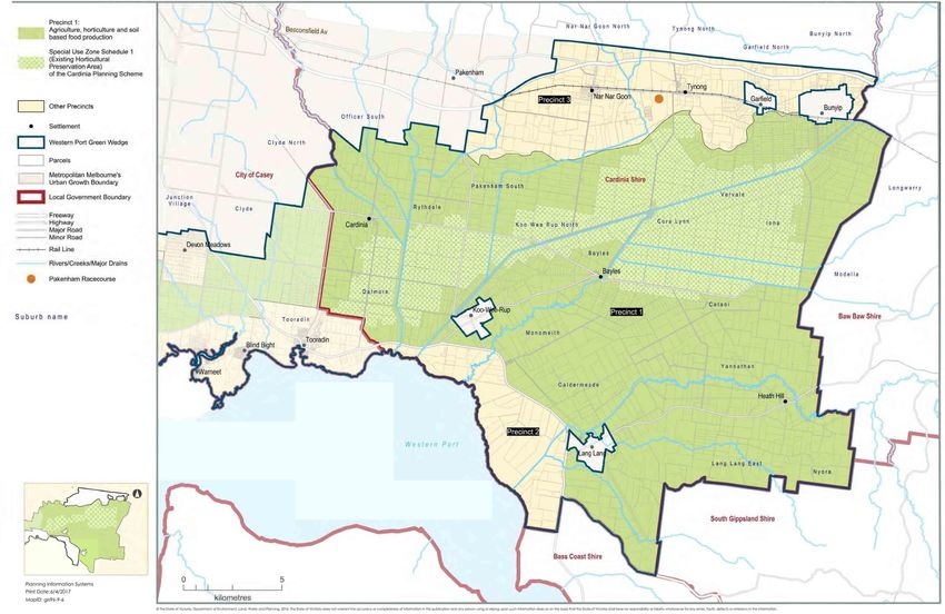
Prepared by:

Cardinia Shire Council
Strategic Planning Unit

Published July 2016May 2017

© Cardinia Shire Council 20162017
ABN: 32 210 906 807
20 Siding Avenue, Officer

PO Box 7, Pakenham Vic 3810
(DX 81006)

Phone: 1300 787 624
Email: mail@cardinia.vic.gov.au
Web: cardinia.vic.gov.au
Contents
1        Executive summary                                                                             4
2        Acknowledgement                                                                               5
3        Introduction                                                                                  6
3.1      Background                                                                                    6
3.2      Consultation                                                                                  6
3.3      What is a green wedge?                                                                        7
3.4      What is the Western Port Green Wedge?                                                         8
3.5      Location                                                                                      8
3.6      State policy                                                                                 11
3.7      Local policy                                                                                 14
3.8      Council Plan                                                                                 15
4        Purpose and vision                                                                          1716
4.1      Management plan purpose                                                                     1716
4.2      Vision                                                                                      1817
5        Land use history                                                                            1918
5.1      Indigenous cultural heritage                                                                1918
5.2      European settlement                                                                         2019
5.3      Pressures for change                                                                        2120
5.4      Attributes and values                                                                       2221
5.5      Community values and priorities                                                             2322
6        Guiding principles                                                                          2625
7        Theme-based strategic directions                                                            2726
7.1      Indigenous and post-contact heritage                                                        2726
7.2      Landscape                                                                                   2928
7.3      Environmental significance                                                                  3029
7.4      Visitation and recreational land uses                                                       3332
7.5      Soils and land capability                                                                   3736

Cardinia Shire Council                           Cardinia Western Port Green Wedge Management Plan          1
7.6    Water                                                                                               4241
7.7    Groundwater                                                                                         4544
7.8    Agriculture and horticulture                                                                        4645
7.9    Climate change                                                                                      5049
7.10   Urban development                                                                                   5251
7.11   Infrastructure and transport                                                                        5655
7.12   Extractive industry                                                                                 5756
8      Precinct-based strategic directions                                                                 6059
8.1    Precinct 1: Agriculture, horticulture and soil based food production                                6261
8.2    Precinct 2: Coastal                                                                                 6665
8.3    Precinct 3: Railway                                                                                 6867
9      Implementation                                                                                      7170
9.1    Purpose                                                                                             7170
9.2    Guiding principles                                                                                  7170
9.3    Actions in the implementation plan                                                                  7170
9.4    Monitoring and evaluation                                                                           7271
9.5    Implementation plan                                                                                 7372
10     The Cardinia Western Port Green Wedge Management Plan – Action Plan                                 8281
11     Abbreviations and glossary                                                                          8382
12     Appendices                                                                                          8887

2                                                      Cardinia Western Port Green Wedge Management Plan          Cardinia Shire Council
List of figures
Figure 1.       Map 1: Context Map                                                                               9
Figure 2.       Map 2: Study area                                                                               10
Figure 3.       Map 3: Habitat corridors and biodiversity                                                       32
Figure 4.       Map 4: Proposed future shared paths                                                             36
Figure 5.       Map 5: Agricultural biophysical land versatility regions                                        40
Figure 6.       Map 6: Coastal acid sulphate soils                                                              41
Figure 7.       Map 7: Settlements and zones                                                                    55
Figure 8.       Map 8: Infrastructure and extractive industries                                                 59
Figure 9.       Map 9: Cardinia Western Port Green Wedge precincts                                              61
Figure 10.      Map 10: Precinct 1                                                                              65
Figure 11.      Map 11: Precinct 2                                                                              67
Figure 12.      Map 12: Precinct 3                                                                              70

List of tables
Table 1.        Summary of key findings from public consultation held in 2011                                   24
Table 2.        Impact of rising temperatures and reduced rainfall                                              50
Table 3.        Cardinia Western Port Green Wedge Implementation Plan                                           73

Cardinia Shire Council                                      Cardinia Western Port Green Wedge Management Plan        3
1 Executive summary The management plan has an overarching
vision which is underpinned by the following:
The Cardinia Western Port Green Wedge guiding principles
Management Plan has been prepared by theme-based strategic directions
Cardinia Shire Council. It provides a precinct-based strategic directions.
strategic planning framework that enables
Council to take advantage of opportunities Key strategies included in the management
and proactively attend to challenges plan are:
occurring in the Cardinia Western Port Green promoting soil-based agriculture and
Wedge over the next 20 years. horticulture
protecting the Green Wedge’s valued
Western Port’s internationally recognised
environment and landscape, and
environment, its established agriculture
improving its biodiversity
industry, rich agricultural soils, ready access
to water, and its extensive transportation providing strategic directions for the
network (connecting farmers with nearby Green Wedge’s townships
local markets and to ports for interstate or planning for climate change.
overseas markets) creates the area’s
enormous (largely latent) economic Objectives, strategies and actions are
potential. The management plan identifies provided for each theme in order to
strategies that aim to realise this potential, implement the management plan over the
which will have flow-on effects on the local next five years.
economy and employment, and the vibrancy
of the settlements in the Green Wedge.
The management plan provides Council with
a tool that can assist in influencing
appropriate planning of the Cardinia Western
Port Green Wedge at state level through the
Metropolitan Planning Strategy Plan
Melbourne which identifies the Western Port
Green Wedge as being part of Melbourne’s
peri-urban area.
4 Cardinia Western Port Green Wedge Management Plan Cardinia Shire Council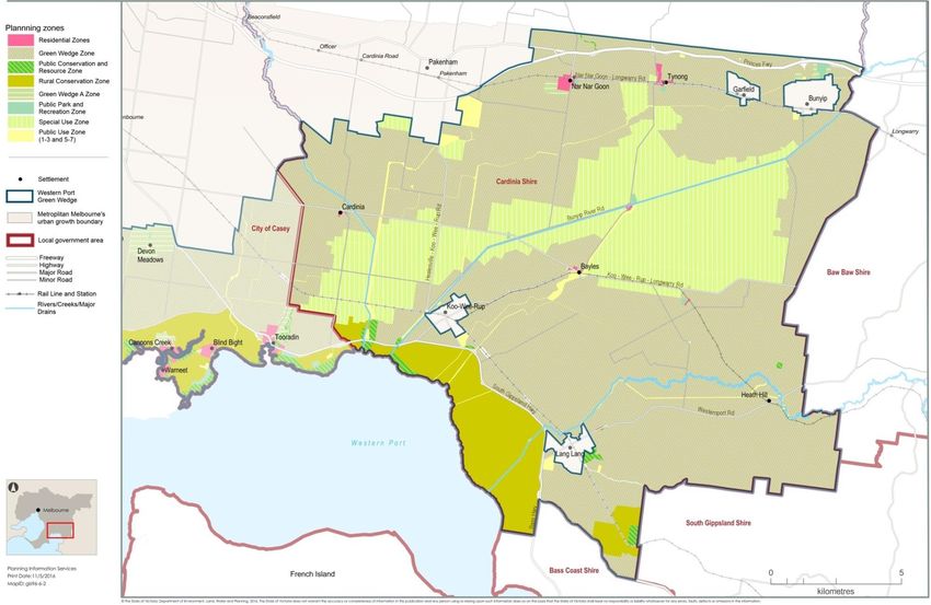
2        Acknowledgement
Cardinia Shire Council respectfully
acknowledges that the land that is the
subject of the Cardinia Western Port Green
Wedge Management Plan is the traditional
land of the Mayone Buluk clan of the Boon
Wurrung people and the Wurundjeri Baluk
clan of the Woi Wurrung people, both of
whom form part of the Kulun Nation.

After community consultation, Cardinia Shire
Council uses the term ‘Aboriginal’ rather
than ‘Aboriginal and Torres Strait Islander’ in
all its documentation. This is in line with the
National Aboriginal Community Controlled
Health Organisation’s (NACCHO) November
2012 resolution, whereby the term
Aboriginal would be used in all
correspondence and speeches (Resolution:
RES 2009–10). ‘Aboriginal’ is deemed to
represent the views and demographics
within the shire.

Cardinia Shire Council acknowledges the
work undertaken and the support provided
by the City of Casey during the first stage of
the development of this document;
specifically, during the issues and
opportunities paper and the draft Western
Port Green Wedge Management Plan
(December 2014).

Cardinia Shire Council also wish to
acknowledge Planisphere for assistance with
the community engagement process.

Cardinia Shire Council                            Cardinia Western Port Green Wedge Management Plan   5
3        Introduction                                   of both councils in relation to the
                                                            management plan. The City of Casey has
    3.1           Background                                proceeded to prepare its management plan
                                                            for that part of the Western Port Green
    The Western Port Green Wedge covers the                 Wedge which is within its municipal area.
    southern mainly rural areas of Cardinia Shire
    Council and the City of Casey.                          It is important to acknowledge that many
                                                            areas of common interest still remain,
    In 2010, the Victorian Government provided              including the purpose and vision, primary
    funding to Cardinia Shire Council and the               industry, biodiversity protection and
    City of Casey to support the preparation of a           enhancement and the natural environment
    joint mManagement pPlan for the Western                 including the Ramsar Wetlands. The
    Port Green Wedge. This funding was used in              management plan is drafted to ensure that
    part to prepare a discussion paper in relation          both Cardinia Shire Council and the City of
    to the Western Port Green Wedge which was               Casey work together in pursuit of these
    completed and publicly exhibited in late                interests.
    2011 and the draft Western Port Green
    Wedge Management Plan (December 2014)                   3.2         Consultation
    which was exhibited in 2015.                            Extensive consultation has been undertaken
                                                            as part of the development of this
    Preparation of the management plan                      management plan. The involvement of and
    advanced to an initial draft prior to the               consultation with the various stakeholders
    release of the Victorian Government’s                   from the community, agencies and
    metropolitan strategy Plan Melbourne. A                 government authorities has been an
    decision was made by both councils to not               important component in the development of
    advance the draft until there was greater               the document. Three consultation phases
    clarity around Plan Melbourne and its                   have informed the development of
    implementation. Once Plan Melbourne was                 management plan, which are outlined below.
    finalised, the draft Western Port Green
    Wedge Management Plan (December 2014)                   Phase 1 – Initial consultation
    was completed in and placed on public                   Phase 1 was undertaken in May 2011 and
    exhibition in late 2015.                                involved a number of engagement activities
                                                            designed to examine the key challenges and
    The partnership between Cardinia Shire                  opportunities for the Western Port Green
    Council and the City of Casey concluded                 Wedge and identify a vision for the area.
    following a decision made by Cardinia Shire
    Council on 15 February 2016 to finalise the             The methodology was devised to reach a
    management plan independently within its                broad cross section of government and
    own municipal area. This decision was made              agencies, industry representatives, local
    due to a divergence in the strategic direction          businesses, community organisations,

6       Cardinia Western Port Green Wedge Management Plan                              Cardinia Shire Council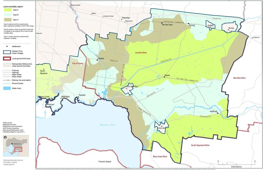
interest groups and community members. online engagement via a website which online engagement which included
The following activities formed part of the hosted associated documents and Facebook, Twitter and both council
engagement methodology: questionnaires. websites
government and agency workshop local papers
key stakeholder group workshops The purpose of the above engagement direct mail.
community survey activities was to obtain feedback for the
online survey draft Western Port Green Wedge Eighteen submissions were received by
interviews with key stakeholders. Management Plan as well as to gain an Cardinia Shire Council and 160 by the City of
More than 150 people participated in understanding of key issues, key Casey.
Phase 1. opportunities, priority areas and ideas for
action relating to the future land use of 3.3 What is a green wedge?
Phase 2 – Discussion paper the area. The term ‘green wedges’ refers to the non-
The Western Port Green Wedge urban land that surrounds the outward
Management Plan – Discussion Paper was Twelve submissions were received. development of Melbourne. This land is
prepared in conjunction with the City of separated from urban areas by the Urban
Casey and was developed from feedback Phase 3 – Draft Western Port Green Wedge Growth Boundary (UGB) which was put in
received during Phase 1. This discussion Management Plan place by the Victorian Government in 2002.
paper was placed on exhibition for public The draft Western Port Green Wedge
comment from 10 October to 5 December Across Melbourne, 12 green wedges are
Management Plan (December 2014) was located in 17 Local government areas. The
2011. To support this exhibition period, a prepared in conjunction with the City of
series of workshops were held, which green wedges accommodate agricultural and
Casey and was exhibited for public recreational uses, as well as a variety of
included the following. consultation and comment from 3 August to
facilitated workshop with government important functions that support
7 September 2015. metropolitan Melbourne. These include
and agency representatives
facilitated workshop with key major assets such as airports, sewage
To support this exhibition period, a series of treatment plants, extractive industry and
stakeholders (township committees, workshops were held, which included the
community groups, growers and industry landfill sites. They contain uses that support
following: urban activity which cannot be located
representatives) two community workshops (Koo Wee
– two evening public information among normal urban development1.
Rup and Garfield)
sessions hosted by: agency workshop (combined with the Townships also exist in green wedges,
Cardinia Shire Council at the City of Casey and facilitated by typically established to provide services in
Cardinia Public Hall Planisphere) support of the primary industries pursued in
City of Casey at the Pearcedale Victorian Government workshop the rural area.
Public Hall (combined with the City of Casey and
facilitated by Phoenix Facilitation)
interviews with key stakeholders
1DELWP, Preparing a Green Wedge Management Plan –
Practice Note 31, June 2015.
Cardinia Shire Council Cardinia Western Port Green Wedge Management Plan 73.4 What is the Western
much of Victoria’s asparagus, celery, leeks 3.5 Location
herbs and silver beet. The ongoing protection
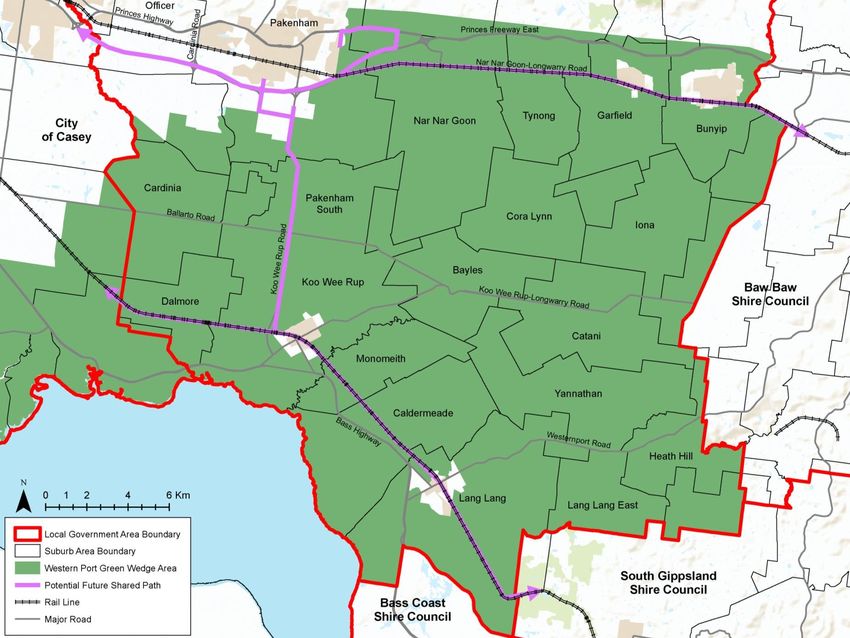
Port Green Wedge? The Western Port Green Wedge is located in
of this important agricultural asset is critical
the southeast of Melbourne and covers an
The Western Port Green Wedge is one of the to the future of the green wedge.
area of approximately 746 square
12 green wedges on the outskirts of kilometres, incorporating land within both
Melbourne located outside of the UGB and is Land within the green wedge area has many
Cardinia Shire Council and the City of Casey.
shared with both Cardinia Shire Council and important purposes including:
Approximately 615 square kilometres of this
the City of Casey. biodiversity, providing habitat for the green wedge land is located within Cardinia
endangered southern brown bandicoot Shire.
Although these areas are set aside as non- and the growling grass frog and the
urban land through the Cardinia Planning internationally significant Ramsar Cardinia Shire localities include (but are not
Scheme, green wedges are continually wetlands
limited to) Bunyip, Longwarry, Modella,
subject to intense pressures for urban providing land for agricultural use Catani, Heath Hill, Nyora and Lang Lang in
development and change. Often competing recognising and protecting land that has the east. It adjoins the Bass Coast Shire and
pressures occur from urban development, agricultural and environmental values the South Gippsland Shire as well as the
hobby farms, tourism, intensive agriculture providing important natural resources, Western Port coast.
and infrastructure because of the proximity including existing sand extraction
to a city which has a population of industry Map 1 outlines the Western Port Green
approximately four and a half million people. encouraging sustainable farming Wedge within the metropolitan context and
activities and providing opportunity for a in relation to the other 11 green wedges.
A proactive approach is required to ensure variety of productive uses
that these pressures are appropriately protecting, conserving, and enhancing Map 2 shows the Western Port Green Wedge
managed and that the liveability, economic the character of open rural and scenic study area including the main settlements
values and the scenic and natural qualities non-urban landscapes and the Urban Growth Boundary.
of the green wedge are not eroded over time. providing infrastructure such as sewage
Green wedge management plans identify treatment plants and airports
these values and work with the local supporting recreational activities such
community to set priorities and make as the Pakenham Racing Club’s Tynong
proposals to improve the future planning and Racecourse.
management of these areas.
The liveability and economic values of the
This document focuses on the Cardinia Shire green wedge are extremely important. While
section of the Western Port Green Wedge. A green wedge land may not be actively
large proportion of this area has some of the farmed, it is still important to consider the
best agricultural soil in Melbourne, providing potential use of the land.
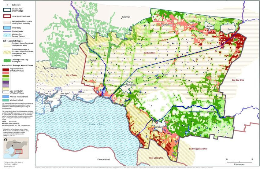
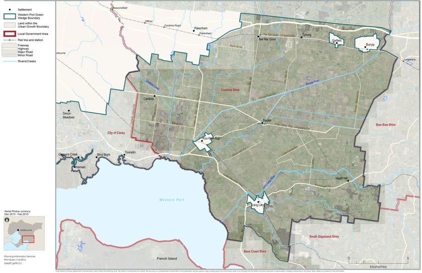
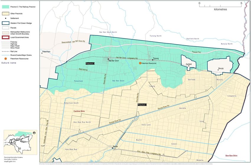
8 Cardinia Western Port Green Wedge Management Plan Cardinia Shire CouncilFigure 1. Map 1: Context Map Cardinia Shire Council Cardinia Western Port Green Wedge Management Plan 9
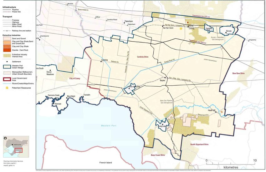
Figure 2.   Map 2: Study area

10                              Cardinia Western Port Green Wedge Management Plan   Cardinia Shire Council
Melbourne to create a more
3.6 State policy Protecting the green wedges and peri-urban consolidated, sustainable city.
State planning policies provide a Victorian areas will make the state’s food supply more
strategic context in which the management secure in the face of increasing climate Principle 4: Environmental resilience and
plan sits. pressures on sustainability
food production. It also and theidentifies the Direction 4.5 - Plan for Melbourne's
Plan Melbourne Metropolitan Planning need to lock in amaintain permanent UGB in green wedges and peri-urban areas
Strategy – 20142017-2050 order to protect the values of non-urban - Policy 4.5.1 - Strengthen protection
Plan Melbourne is the Metropolitan Planning land; including agriculture and agribusiness, and management of green wedge
Strategy for Melbourne and sets the vision biodiversity, recreation and open space, land.
for and guides Melbourne’s growth through tourism, heritage and landscape - Policy 4.5.2 - Protect and enhance
to the year 2050. It identifies the importance conservation. And reduce urban sprawl2. valued attributes of distinctive areas
of retaining green wedges which support and landscapes.
Melbourne through food production, critical The relevant principles, directions and
infrastructure (such as water supply initiatives policies of Plan Melbourne are as Principle 6: Social and economic
catchments and airports), sand and stone follows: participation
supply, biodiversity, recreation and tourism. Principle 1: A distinctive Melbourne Direction 6.3 Integrate urban
Green wedges and peri-urban areas Direction 1.4 – Support the productive development and water cycle
provide opportunities for the community to use of land and resources in management to support a resilient and
connect with nature, improving health Melbourne's non-urban areas. liveable city.
outcomes, as well as maintaining the - Policy 1.4.1 - Protect agricultural land - Policy 6.3.1- Reduce pressure on
ecosystem services that underpin and support agricultural production. water supplies by making the best
Victoria’s prosperity. - Policy 1.4.2 - Identify and protect use of all water sources.
extractive resources (such as stone - Policy 6.3.3 - Protect water, drainage
and sand) important for and sewerage assets.
Melbourne's future needs.
Direction 6.5 - Protect and restore
Principle 2: A globally connected and natural habitats
competitive City Policy 6.5.3 - Protect the coastlines and
Direction 2.1 - Manage the supply of waters of Port Phillip Bay and Western
new housing in the right locations to Port. Direction 5.2 – Protect and restore
meet population growth and create a natural habitats in urban and non-urban
sustainable city. areas
- Policy 2.1.1 - Maintain a permanent – Initiative 5.2.3
urban growth boundary around
Protect the coastlines and waters of
Port Phillip Bay and Western Port.
2DELWP Plan Melbourne Metropolitan Planning Strategy,
March 2017.
Cardinia Shire Council Cardinia Western Port Green Wedge Management Plan 11 Direction 5.3 – Enhance the food Protect significant resources of stone,
production capability of Melbourne and Ensure strategic planning and land sand and other mineral resources for
its non-urban areas. management of each green wedge area extraction purposes.
– Initiative 5.3.1 to promote and encourage its key
Protect high quality agricultural land features and related values. Clause 12.01 Biodiversity seeks to protect
in and around Melbourne for food Support development in the green biodiversity and Clause 12.01-2 Landscapes
production. wedge that provides for environmental, seeks to improve the landscape qualities,
Direction 6.1 – Deliver a permanent economic and social benefits. open space linkages and environmental
boundary around Melbourne. Consolidate new residential performance in green wedges and non-urban
– Initiative 6.1.1 development within existing settlements areas. 12.02 Coastal areas seeks to
and in locations where planned services enhance and encourage sustainable use of
Confirm the mechanism and lock in a coastal areas. Climate change impacts and
permanent boundary. are available and green wedge area
values can be protected. coastal inundation and erosion are
State Planning Policy Framework Plan and protect major state addressed in Clause 13 Environmental
(SPPF) infrastructure and resource assets that Risks.
The SPPF comprises of general principles for serve the wider Victorian community,
such as airports and ports with their Clause 14 Natural Resource Management is
land use and development in Victoria with
associated access corridors, water also of relevance and sub clause 14.01-1
specific policies.
supply dams and water catchments and Protection of agricultural land of which the
waste management and recycling objective is to protect productive farmland
The directions of Plan Melbourne are
facilities. which is of strategic significance in the local
reflected in policy contained in the SPPF of
Plan and protect major transport or regional context.
the Cardinia Planning Scheme.
facilities that serve the wider Victorian
community, such as airports and ports Sub clause 14.01-2 Sustainable agricultural
Clause 9 Plan Melbourne of the SPPF
with their associated access corridors. land use seeks to encourage sustainable
requires consideration of Plan Melbourne.
Protecting important productive agricultural land use.
This clause identifies that the key issues agricultural areas such as Werribee
South, the Maribyrnong River flats, the Sub clause 14.02-2 Water quality of which
relevant to the Western Port Green Wedge
Yarra Valley, Westernport and the the objective is to protect water quality.
include the proposed southeast airport, the
potential aero town, Port of Hastings, Mornington Peninsula.
Also of relevance is Clause 14.03 Resource
required road infrastructure and upgrades Support existing and potential
exploration and extraction of which the
and the growth of green wedge townships. agribusiness activities, forestry, food
objective is to encourage exploration and
production and tourism.
extraction of natural resources in
The overarching policy on green wedges is Protect areas of environmental, accordance with acceptable environmental
located at Clause 11.06 landscape and scenic value. such as
standards and to provide a planning
SettlementMetropolitan Melbourne, under biodiversity assets, national and state
approval process that is consistent with the
sub clause 11.064-7 Green wWedges. parks, Ramsar wetlands and coastal
relevant legislation.
Relevant strategies in relation to the areas.
protection of the green wedge are as follows:
12 Cardinia Western Port Green Wedge Management Plan Cardinia Shire CouncilOther planning scheme provisions natural environment with minimal To minimise the potential for conflict
Zones degradation of the natural environment or between residents and normal farming
Green Wedge Zone (GWZ) natural processes. practices that are related to the conduct
The purpose of this zone is to recognise and of agricultural activities.
protect non-urban land outside the Rural Conservation Zone (RCZ) To encourage sustainable farming
UGB in the Melbourne metropolitan area for This zone is designed to protect and activities based on whole farm and
its agricultural, environmental, historic, enhance the natural environment for its catchment planning principles on an
landscape or recreational values, or mineral historic, archaeological, scientific, individual and community basis.
and stone resources. The zone provides a landscape, faunal habitat and cultural
values. Agriculture is allowed, provided it is Overlays
minimum lot size of 40 hectares unless an
alternative is specified in a schedule to the consistent with the environmental and Environmental Significance Overlay (ESO)
zone. The creation of smaller lots is allowed landscapes values of the area. This zone This overlay applies to areas where the
under particular circumstances. could also be applied to rural areas development of land may be affected by
degraded by environmental factors such as environmental constraints. It also seeks to
salinity or erosion. A schedule requires ensure that development is compatible with
Green Wedge A Zone (GWAZ)
This zone provides opportunity for most specific conservation values to be stipulated. identified environmental values.
agricultural uses and limits non-rural uses to The zone provides a minimum lot size of 40
those that support agriculture or tourism hectares unless an alternative is specified in Land Subject to Inundation Overlay
provided that the amenity of residential living a schedule to the zone. The creation of (LSIO)
is protected. It seeks to protect and enhance smaller lots is allowed under particular This overlay applies to land in either rural or
the biodiversity, natural resources, scenic circumstances. urban areas that is subject to inundation, but
landscapes and heritage values and to is not part of the primary floodway.
promote sustainable land management. Special Use Zone – Schedule 1 (SUZ1)
It also provides opportunity for limited (Horticultural Preservation) Restructure Overlay (RO)
residential development subject to a permit. This zone provides for the use of land for This overlay applies a restructure plan to old
The zone provides a minimum lot size of 8 specific purposes, in this case horticultural and inappropriate subdivisions as a
hectares unless an alternative is specified in preservation. The purpose of this zone is as condition of development approval. It seeks
a schedule to the zone. The creation of follows: to preserve and enhance the amenity of an
smaller lots is allowed under particular area and reduce the environmental impacts
circumstances. To preserve land of high agricultural of dwellings and other development.
quality for horticulture and other farming
Particular provisions
Public Conservation and Resource Zone activities.
To discourage non-agricultural and non- Clause 57 Metropolitan Green Wedge
(PCRZ)
soil based uses establishing on soil of Land
This zone protects and conserves the natural
high agricultural value. This clause applies to land outside of the
environment and natural processes for their
To protect the area from the UGB (unless otherwise specified). The
historic, scientific, landscape, habitat or
encroachment of urban and rural purpose of this clause is to:
cultural values. It also allows for the
construction of facilities which assist in residential type development. Protect metropolitan green wedge land
public education and interpretation of the from uses and development that would
diminish its agricultural, environmental,
Cardinia Shire Council Cardinia Western Port Green Wedge Management Plan 13cultural heritage, conservation, 3.7 Local policy
landscape natural resource or Of relevance is sub Clause 21.02-2
Local planning policies provide a local and
recreation values. Landscape of which the objective is to
regional strategic context in which the
To protect productive agricultural land recognise and protect the diverse landscape
management plan sits.
from incompatible uses and and areas of significant landscape value. It
development. identifies the following relevant key issues:
Local Planning Policy Framework (LPPF)
To ensure that the scale of use is The Municipal Strategic Statement (MSS) Protecting significant landscapes,
compatible with the non-urban provides the vision for land use planning and including the protection of the specific
character of metropolitan green wedge development within Cardinia Shire and features of each landscape.
land. identifies the following in relation to the Recognising that the landscape is an
To encourage the location of urban green wedge. important element in the sustainable
activities in urban areas. development of tourism in the
To provide transitional arrangements for Clause 21.01 Cardinia Shire key issues and municipality.
permit applications made to the strategic vision identifies Western Port as a Recognising the pressures to develop
responsible authority before 19 May major landscape feature and that a key land in locations of high scenic value.
2004. influence within the shire is urban growth,
including urban pressures on the rural Clause 21.02-3 Biodiversity identifies the
The clause also provides for additional hinterland and management of green wedge diverse environment that is Cardinia Shire.
controls on uses of green wedge land above areas. The following relevant key issues are The objective is to achieve a net gain in the
and beyond those authorised under the identified: quantity and quality of native vegetation in
other zones that make up the green wedge. The protection of environmentally the municipality.
Practice notes significant areas including the northern Clause 21.03 Settlement and housing
hills and the Western Port coast. provides guidance in relation to rural
The Victorian Government have a series of
The protection and management of townships and identifies that setting clear
practice notes on the operation of the
biodiversity. limits for development of the townships and
Victorian Planning Provisions (VPP).
The protection of the Koo Wee Rup designing with regard to the surrounding
Preparing a Green Wedge Management Plan swamp area which contains important unique characteristics of the townships as
– Planning Practice Note 31 groundwater reserves and horticultural key issues.
This practice note is to help guide the soils in the Western Port basin.
preparation of green wedge management The management of urban growth, Clause 21.04 Economic Development is also
plans and outlines the general requirements including urban pressures on the rural of relevance. The objective of sub Clause
that should be met in the preparation of the hinterland. 21.04-2 Agriculture is to maintain agriculture
document. The protection and sustainable use of as a strong and sustainable economic
agricultural land. activity within the municipality. The following
The Cardinia Western Port Green Wedge key issues are also identified:
Management Plan has been prepared in Clause 21.02 Environment identifies that the Maintaining and protecting high value of
accordance with this practice note and majority of Cardinia Shire is located within agricultural land within the municipality.
responds appropriately to all of the policy the Western Port catchment, which is a Protecting productive agricultural land
outlined above. Ramsar wetland. from incompatible uses and
14 Cardinia Western Port Green Wedge Management Plan Cardinia Shire Councilinappropriate development and will respond to the opportunities and agriculture is facing pressure from the
subdivision, including non-soil based challenges facing Cardinia Shire. changing world economy, changing
farming on lands with high soil quality. climate and other environmental
Accessing sustainable water supplies Council’s vision is Cardinia Shire will be conditions, as well as the demands of
for agricultural activities. developed in a planned manner to enable development and the ageing of our
Recognising the impact of intensive present and future generations to enjoy and farming community.
farming on surrounding uses. experience the diverse and distinctive Council will take up every opportunity to
Developing Green Wedge Management characteristics of our Shire.3 enhance agricultural production
Plans to fulfil statutory, strategic, particularly in the southern rural region
environmental, economic and social The Council Plan has been amended for the (Bunyip Food Belt) by using recycled
requirements. period 2016–17. The following relevant key water from the Eastern Treatment Plant
challenges have been identified. at Carrum.
Further strategic work is identified at this
clause and requires the preparation of Green Managing the natural and built environment, Section 3 Our environment is relevant; the
Wedge Management plans for the three including climate change. objective is we will continue to continue to
green wedges in conjunction with the The quality of our natural and built plan and manage the natural and built
relevant councils and government environments affects our communities. environment for present and future
departments. They must be developed and managed generations.
in a way that contributes to the health
Clause 22.02 Sand extraction – Lang Lang and safety of present and future Action 3.5.4 of the Council Plan seeks to
to Grantville region identifies that this region generations. ensure the planning of rural (green wedge)
contains significant sand resources which Existing natural environmental values areas protects and enhances important
are expected to become a major source of such as biodiversity and waterways agricultural, environmental, natural
sand for the Melbourne supply area over the need to be protected and improved. resource, infrastructure and recreational
next 10 to 20 years. Climate change is affecting our values.
agricultural areas, community health,
The objective of this clause is to protect sand parks and recreational facilities. The objective at Section 4 Our economy is
resources in the Lang Lang – Grantville area we will create and support local employment
and to provide for the extraction of these Supporting and increasing agricultural and business opportunities for our
resources and rehabilitation of sites in a productivity community and the wider region.
manner which protects the significant With the majority of Cardinia Shire’s
environmental, social and economic values land being rural, the hills and southern Section 4.2 Maintain strong agricultural
of the area. rural regions are important to the activities.
economy at a local and national level.
3.8 Council Plan In order to achieve the above, the following
Council needs to protect and strengthen
The Council Plan (2013–17) sets out a these areas, and recognises that actions are listed:
medium- to long-term vision for how Council
3 Cardinia Shire Council, Council Plan 2013-17
Cardinia Shire Council Cardinia Western Port Green Wedge Management Plan 154.2.1 Support our farmers and growing
agricultural industry in adapting to
the changing economy and climate.
4.2.2 Identify innovative ways to value add
to the region’s primary production
and transportation.
4.2.3 Advocate for the development of
roadways to value add to the region’s
primary production and
transportation.
16 Cardinia Western Port Green Wedge Management Plan Cardinia Shire Council4 Purpose and vision Actions relate to more tangible or
measurable tasks; an action is a task that
4.1 Management plan can be allocated, placed within a timeframe,
and may even need specific funds allocated.
purpose
The management plan is a strategic The management plan achieves:
framework which will guide the planning of identifies the values and features of the
the southern (primarily rural) areas of Cardinia Western Port Green Wedge
Cardinia Shire Council over the next 20 across a range of thematic areas,
years. It is envisaged that a review will be including biodiversity, agriculture and
undertaken every five years. However, it is horticulture, water, climate change,
not intended that the review will make cultural heritage and more
significant changes to the vision, objectives provides objectives, strategies and
and actions (unless required). It may identify actions to protect and improve the
emerging issues, remove completed actions quality of these important assets
and identify any new actions in response to identifies areas of commonality through
new and emerging issues. the identification of precincts and sets
out the preferred future land uses in
The management plan brings together a these areas
range of objectives, strategies and actions to acknowledges and responds to the needs
help protect, improve and promote the and values of the local community
area’s important economic, social and
identifies priority actions and further
natural assets in the face of the challenges
work that is required to successfully
and pressures which arise from its location
manage the Cardinia Western Port
at the edge of metropolitan Melbourne and
Green Wedge into the future.
in the face of a changing environment.
An objective articulates what the structure
plan aims to achieve in relation to a
particular theme, such as the goal intended
to be attained or the desired outcome.
Strategies and actions are similar; they both
provide a solution to achieving the objective.
However, for the purpose of this structure
plan, strategies relate to the method or
processes used to achieve the objective,
such as how Council will assess and guide
proposals within the green wedge.
Cardinia Shire Council Cardinia Western Port Green Wedge Management Plan 174.2 Vision
A vision for the Western Port Green Wedge
was developed through background research
and extensive stakeholder consultation The vision is:
involving the primary industry, local The Cardinia Western Port Green Wedge will be a permanent
government, state and federal government green and rural area. It will remain an internationally significant
agencies, utility and service providers, biodiversity habitat, while also strengthening its agricultural and
environmental groups, resident associations horticultural role to become a truly innovative and productive
and property owners and occupiers. farming district. Agriculture, horticulture and soil based food
production for the long-term food security of Victoria is at the heart
This was undertaken in 2011 as part of the of this vision.
preparation of the project’s Western Port
Green Wedge Management Plan Discussion
Best practice integrated water management will lead to improved
Paper, October 2011 jointly with the City of
Casey. water quality and a reduced risk of flooding with improved
ecological conditions in Western Port Bay and local biodiversity will
Some minor amendments have been made be protected, as will habitats for threatened species.
to the vision to make it more Cardinia
specific. The green wedge will be home to small, clearly defined
settlements that have a strong identity, provide jobs and services
for the local community and support the agricultural and
horticultural pursuits of the green wedge.
The local economy will be driven by its agriculture, horticulture and
extractive industry. The Cardinia Western Port Green Wedge
provides the opportunity to accommodate a further third airport to
serve the long-term needs of Southeast Melbourne and Gippsland
as identified in Plan Melbourne.
The Cardinia Western Port Green Wedge will be the permanent
edge to Melbourne’s southeast.
18 Cardinia Western Port Green Wedge Management Plan Cardinia Shire Council5 Land use history Wurrung, the Djaja Wurrung and the Taung
Wurrung peoples who all shared a
The Western Port Green Wedge boundaries common language.5
abut the Western Port coast, the low lying
former Koo Wee Rup and Dalmore swamps, The Boon Wurrung, with their
(which together formed the largest swamp in hunter/gatherer lifestyle, followed traditional
Victoria), as well as pockets of more elevated routes along the coast, creeks and
land to the north. The inland Koo Wee Rup riversides. Some of these routes were
Swamp was dominated by permanently mapped by William Thomas who was
inundated reeds and rushes, and the coastal appointed Assistant Protector of the
Dalmore Swamp featured dense scrub and Aborigines in 1837 by Baron Glenelg, the
swamp paperbark. These swamps created a British Secretary of State for the Colonies. On
natural barrier between Melbourne and West arriving in Victoria, the Chief Protector,
Gippsland. George Augustus Robinson, allocated him
the Port Phillip, Western Port and Gippsland
5.1 Indigenous cultural districts which include the entirety of the
heritage study area. He travelled extensively with the
The Western Port area is a part of the Aboriginal peoples of these districts including
traditional country of the Mayone buluk and the sea coast from Western Port to Port
Yallock balug clans of the Bun Wurrung Phillip and drew a map in 1840, which
people and the Bulug willam clan of the Woi showed some of these journeys.
Wurrung.4 For tens of thousands of years,
the ancestors of these groups experienced One of these tracks passed around the east
extremes of environmental fluctuation from side of the Western Port study area from
volcanic eruption, the ice age (during which Gippsland, linking up with well-established
sea levels dropped and dry land extended to trails through the Berwick and Pakenham
Tasmania creating the Bassian Plain, a vast areas to Dandenong. Another track along
grassland and hunting territory) and then the west side of the bay passed near the
climatic warming (when this plain was Tooradin area before joining the track
inundated) leading to the creation of to Dandenong.
Western Port as it is now seen.
The Boon Wurrung and the Woi Wurrung
The Boon Wurrung and the Woi Wurrung peoples intermarried and traded, moving
people are part of the broader alliance of the freely (in accordance with mutually
Kulin Nation which also includes the Watha understood protocols) across each other’s
4Canning, S. & Thiele, F. Indigenous Cultural Heritage and Australian Cultural Heritage Management, report for to the 5Rhodes, D. & Bell, J Shire of Cardinia Urban Growth Corridor
History within the Metropolitan Melbourne Investigation Area, Victorian Environmental Assessment Council, 2010. Aboriginal Heritage Study, report to the Shire of Cardinia,
2004.
Cardinia Shire Council Cardinia Western Port Green Wedge Management Plan 19territories. According to some observers, the rhythms of the seasons. They created Permanent European settlement of the area
their contact was so frequent and so sites that contain important evidence of a occurred progressively from the 1830s.
amicable, that boundaries between distant past and to which they attribute Typical early uses included fishing, grazing
them may not necessarily have been spiritual meaning. and farming. However, intensive farming was
rigidly defined. hindered by dense vegetation, the threat of
Most of the Western Port Green Wedge has flooding and the extensive swamps.6
Their movements were seasonal. During not been surveyed in any detail to establish
summer months they travelled along major the Aboriginal archaeological values which In the 1870s the Lands Department decided
streams, fishing for eels, and hunting and remain there. The largest and most to drain the Koo Wee Rup Swamp so that it
snaring game such as kangaroos, wallabies, significant sites found to date have been on could be farmed and the Koo Wee Rup
possums, wombats and emus. They elevated land on the swamp periphery, south Drainage Committee was formed to oversee
gathered plant foods, ate swamp-dwelling of Pakenham. Further research is required to the process. The main channel connecting
plants like the roots of rushes, and collected clearly identify Aboriginal heritage values in the Cardinia Creek and a number of smaller
wild honey. In the cooler months, the Boon the study area. drains were excavated from 1876 using
Wurrung people moved inland seeking shovels and wheelbarrows, but these initial
shelter and gathered pith of tree ferns and 5.2 European settlement efforts proved unsuccessful and major floods
fished Cardinia Creek. European settlement of the area quickly led still occurred. The drainage system was
to the end of the traditional lifestyle of the extended from 1889 with the construction of
The land was well watered and was Aboriginal peoples as they lost access to the Bunyip Main Drain to channel the Bunyip
managed to provide plentiful food resources traditional lands and waterways, hunting River through to Western Port Coast.7
and shelter for its numerous inhabitants for grounds were reduced and traditional food
over 40 millennia. In common with the sources disappeared. Hunger, conflict with
practice of Aboriginal people throughout Europeans, as well as the introduction of
Australia, they skilfully used fire to clear new diseases (to which the Indigenous
forest areas into patchwork patterns to peoples had no immunity) led to rapid
foster new plant growth; particularly grasses population decline and loss of territory. It
to attract game and to promote the growth of also meant that the relationship between the
herbs, tubers, native fruits and nuts to natural environment in the Western Port
balance their diet and to forestall bush fire area and human activity changed from one
conflagration. of harmony to one of seemingly constant
struggle as Europeans sought to tame the
The Kulin people had a rich spiritual life land by removing vegetation, draining it and
which centred on connections with Bunjil, opening it up for agricultural production and Station Street Koo Wee Rup during the
the spirit who created the land, their passage through to East Gippsland. 1934 flood.8
custodianship and protection of it and with
6Canning, S and Thiele, F), Indigenous Cultural Heritage and Australian Cultural Heritage Management, report for to the 7 Graeme Butler and associates), Cardinia Shire (Emerald and
History within the Metropolitan Melbourne Investigation Area, Victorian Environmental Assessment Council 2010. Cranbourne Districts) Heritage Study, 1998.
8 Casey Cardinia Links to our past
20 Cardinia Western Port Green Wedge Management Plan Cardinia Shire CouncilThe first village settlement was then built but damage and the latter made more than was declared a groundwater conservation
flooding occurred again in 1893 leading to 1,000 people homeless. The 1936 Royal area in 1971, which controlled the rate and
further widening and deepening of the main Commission was set up to produce an volume of water that could be extracted and
drain. Drainage works were completed by improved scheme with new levees, the prohibited new bores in some areas.12
1897. The new drainage system and drought removal of sediment, and a further extension
then led to the soil shrinking and compacting of the system. 5.3 Pressures for change
with the land surface dropping as a The Western Port Green Wedge has a history
consequence. A major flood in 1900 caused By the time of World War II, potato growing in of struggle between retaining and protecting
damage to crops and livestock and a new the area had ceased due to market the natural environment from urban
round of widening and extension of the fluctuations, and the area then became the development and human activity. This is not
drainage system took place as a result. prime supplier of Melbourne’s milk and a situation unfamiliar to the Green Wedge
Nevertheless, the area was proving to be vegetables. Through the 1950s and 1960s areas across Victoria.
fertile land for horticulture and in the early this trend was accelerated by an influx of
1900s the area became the potato capital of growers who were forced out of Melbourne’s The Western Port Green Wedge has many
Victoria.9 traditional market gardens in Dingley and significant environmental values, while also
Oakleigh by urban expansion. Potatoes again being a very important agricultural area. The
Around this time, the hills to the north of the took over as the dominant land use, natural environment will continue to pose
Koo Wee Rup Swamp were extensively replacing dairying, which moved further out challenges as the predicted impacts from
cleared. This in turn led to erosion of the to Gippsland. New sources of water were climate change, such as more frequent
drains because of increased runoff, and needed to provide for this expansion and a inundation, increased storm events and
sedimentation in the lower parts of the permit system was introduced in the 1950s changes to crops. This will create pressure
system. In 1917, the Koo Wee Rup Flood to allow farmers to pump water directly from on both the environmental and agricultural
Protection District was proclaimed to oversee the main drain. Only minor flooding occurred values of the area.
an improved drainage system for the whole after this time and the construction of the
area (this resulted from severe flooding Tarago Reservoir in 1969 also enabled As Melbourne’s population continues to
again in 1911). The needs of World War I better downstream flood control.11 grow, the inevitable urban development
promoted vegetable growing in the area, and pressures on the Western Port Green Wedge
also led subsequently to land subdivision for Groundwater was also being extracted from will continue. It is likely pressure to expand
the creation of small-holdings for returned the aquifers from 1922 for stock and the UGB in order to accommodate new urban
soldiers which were known as soldier domestic requirements. This process went development, rural living, hobby farms and
settlements.10 unchecked until water levels in the aquifers other uses that may compromise the
had dropped by 15 metres and in the 1967– potential productivity of the land will
Major floods in 1923 and 1924 and the 68 drought they fell below pumping levels continue. Pressure is also likely on the Green
super flood of 1934 caused significant and no water could be extracted. The area Wedge area to accommodate state
9Graeme Butler and associates), Cardinia Shire (Emerald 11 Graeme Butler & Associates. (1998), Cardinia Shire
and Cranbourne Districts) Heritage Study, 1998.. (Emerald & Cranbourne Districts) Heritage Study.
10 Rhodes, D. & Bell, J, Shire of Cardinia Urban Growth 12 Rhodes, D. & Bell, J,Shire of Cardinia Urban Growth
Corridor Aboriginal Heritage Study, report to the Shire Corridor Aboriginal Heritage Study, report to the Shire
of Cardinia, 2004. of Cardinia, 2004.
Cardinia Shire Council Cardinia Western Port Green Wedge Management Plan 21infrastructure in order to support Within the Casey–Cardinia Green Wedge, Southern brown bandicoot
metropolitan Melbourne. agriculture employs approximately 2,000 Photo: John Petrucka
people and contributes an estimated
The current and future pressures on the $400 million to the local economy, making it A number of rural townships and settlements
Cardinia Western Port Green Wedge are the most valuable and productive green are located in the green wedge, including:
described in more detail in Section 7. wedge area in Melbourne13. Large rural townships
– Garfield
5.4 Attributes and values The green wedge also accommodates other – Bunyip
While pressures for change will continue (as rural uses such as grazing, horse and – Koo Wee Rup
outlined in Section 5.3), the Cardinia greyhound breeding and training, beef
Western Port Green Wedge is also home to production, hobby farms, rural living, nature – Land Lang
important assets that have value in their own conservation and the various settlements. – Nar Nar Goon
right and have a significant role to play in Small rural townships
making Melbourne a great city. These It has recreation assets such as the – Bayles
include sand extraction (significant sand Pakenham Racing Clubs’ new Tynong – Cardinia
resources exist, particularly around Lang Racecourse and equestrian facilities. The
Lang), sewage treatment plants and other green wedge also has some highly significant – Tynong
important infrastructure such as airports. biodiversity assets including internationally Rural localities
recognised wetlands, and habitats for – Iona
While green wedges play an important role in endangered species including the southern – Cora Lynn
providing infrastructure for metropolitan brown bandicoot and the growling grass frog.
– Catani
Melbourne, this needs to be balanced with a
healthy green wedge environment. This – Heath Hill
creates a healthy eco system that supports – Caldermeade
healthy communities, agricultural production, – Monomeith
recreation and tourism. – Modella
Today, the majority of the study area is used
for agricultural purposes. The region
produces livestock, vegetables, cut flowers
and orchard fruits, but particularly high in
vegetable production with almost 90 per
cent of Victoria’s asparagus is produced in
and around Koo Wee Rup; celery (50%) and
leeks (71%) account for significant
proportions of the state’s output.
13 Integrated Water Management Plan
22 Cardinia Western Port Green Wedge Management Plan Cardinia Shire Council– Yannathan14.
These engagement activities were designed
These townships play an important role to examine the key challenges and
within the green wedge, providing opportunities for the Western Port Green
opportunities for non-urban township living, Wedge, identify a vision for the areas and
as well as providing a focus for the local explore potential actions for the draft
provision of services, schools and Western Port Green Wedge Management
employment. Plan. Feedback collected during the
exhibition of the discussion paper informed
The Cardinia Western Port Green Wedge also the content of the draft and the final
has a number of existing tourist attractions document.
and potential exists to expand tourism
opportunities that complement the other A report summarising the feedback from
values of the green wedge, particularly community consultation in 2011 is available
including increased food-based tourism and separately. This report was prepared by
eco-tourism that has minimal impact on the Capire Consulting Group and is called the
green wedge environment. Western Port Green Wedge Management
Plan – Community Stakeholder Engagement
5.5 Community values and Summary of Findings (May 2011). Key
priorities findings of this report are available in Table1.
The Western Port Green Wedge is home to
more than 20,000 people, all of whom have
different experiences and relationships with
the green wedge. Over half of these people
live in the rural townships; the remainder
live on rural properties.
Many of these community members and
local stakeholders were involved in the
development of the Western Port Green
Wedge Management Plan Discussion Paper
(October 2011) and final management plan
through engagement activities that included
workshops, community surveys, online
surveys and interviews with key
stakeholders.
14Cardinia Planning Scheme, Clause 21.03-3 Rural
townships
Cardinia Shire Council Cardinia Western Port Green Wedge Management Plan 23Table 1. Summary of key findings from public consultation held in 2011
Theme Feedback
Agriculture A primary value and key asset needing protection
Need for clear zoning based on land capability, soil and commodity studies
Need for improved management of farms, including incentives for farmers to stay on the land and to improve farming practices
Need for better management of interface between residential and farming areas into the future
Key challenge of managing succession planning for ageing farmers; potentially need greater flexibility for farmers to subdivide or to
undertake complementary activities such as farm gate sales or food tourism
Biodiversity Biodiversity identified as a valuable asset, particularly the internationally recognised Ramsar wetlands and endangered species such as
the southern brown bandicoot and the growling grass frog
Potential strategies included building on the bio-links programs with incentives to revegetate or help improve them
Suggestions included developing bio-links from Cranbourne Botanic Gardens south to the coast as well as east to Bayles to help protect
native flora and fauna
Specific comments regarding the alignment of some bio-links and also concerns regarding how these had been identified and whether
they would be effective
An integrated approach to ensure that agriculture and water management helps to improve habitats for valued species was also supported
Urban Widespread opposition to further subdivision in the green wedge
development Seventy-two submissions explicitly opposed subdivision and advocated for the Urban Growth Boundary to be the permanent edge to
pressures Melbourne, and two petitions with 70 signatures opposed subdivision
Some submissions suggested that infill development could be encouraged in small settlements to make them more viable and others felt
that a buffer zone between agricultural and residential areas could minimise conflict and that rural living could act as this buffer
Future growth at the Port of Hasting was highlighted along with the impact this will have on freight movement and travel patterns across
the area
Water Flooding seen as a major concern for the green wedge and many linked this to runoff from new development and hard surfaces in the
catchment areas
Water-sensitive urban design (WSUD) was advocated to reduce the severity of flooding along with an integrated approach to water
management; the impacts of runoff on the Western Port seagrass and saltmarsh ecosystems were a concern for some respondents
The need to address rising sea levels was raised with suggestions to restrict inappropriate development and to promote revegetation along
the coast
Recreation and Key opportunity for leisure and tourism that complements the green wedge to improve the local economy (e.g. educational tourism,
tourism agricultural schools, tourism connected to local produce, and eco-tourism along the coast)
Support for a walking track along the Western Port coast although some concern about its impact on the Ramsar wetlands and its
practicability
Support for rail trails and equestrian trails if they can be put in place without threatening local habitats, and particular support was given to
a bicycle trail along the South Gippsland rail easement
24 Cardinia Western Port Green Wedge Management Plan Cardinia Shire CouncilYou can also read