Basingstoke and Deane Landscape Character Assessment - Basingstoke ...
←
→
Page content transcription
If your browser does not render page correctly, please read the page content below
Landscape Architecture
                                                                                                      Masterplanning
                                                                                                             Ecology

Basingstoke and Deane
Landscape Character Assessment

May 2021

hankinson duckett associates
t 01491 838175 e consult@hda-enviro.co.uk w www.hda-enviro.co.uk
The Stables, Howbery Park, Benson Lane, Wallingford, Oxfordshire, OX10 8BA
Hankinson Duckett Associates Limited Registered in England & Wales 3462810 Registered Office: The Stables, Howbery Park, Benson Lane, Wallingford, OX10 8BA
                                                                              Basingstoke and Deane Landscape Character Assessment 2021                       i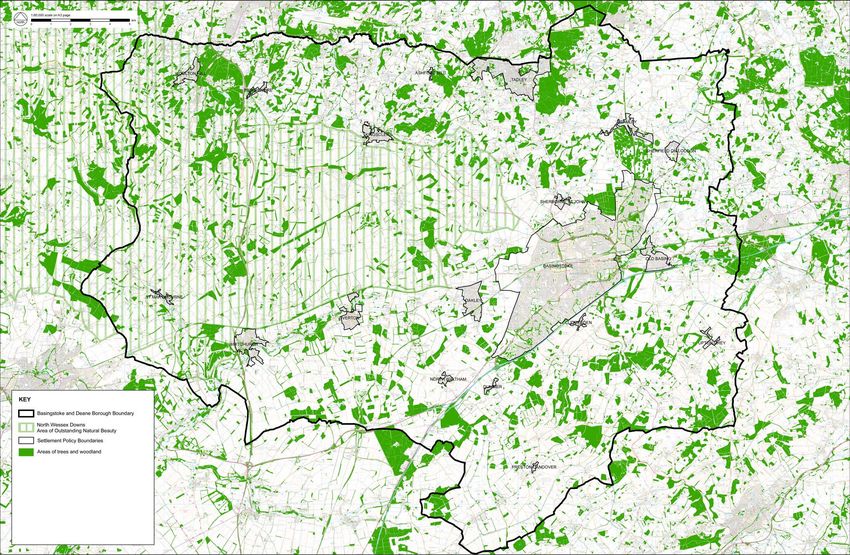
CONTENTS 1 INTRODUCTION
1 Introduction page 1 1.1 In 2019, Basingstoke and Deane Council commissioned Hankinson Duckett Associates (HDA)
to undertake a review of the Borough’s 2001 Landscape Character Assessment. The updated
2 Basingstoke and Deane Landscape Overview page 1 Landscape Character Assessment will be part of the evidence base for the Local Plan and will
help guide spatial planning and development management decisions within the Borough.
3 Landscape and Townscape Types page 19
1.2 The original 2001 study was prepared by Landscape Design Associates in association with
4 Landscape Character Areas Wessex Archaeology, and forms the basis for the revised Landscape Character Assessment,
1. Highclere and Burghclere page 34 updated as appropriate.
2. Ecchinswell page 40
3. Wolverton page 46 1.3 The 2001 study has been updated taking into account both changes to the landscape, and the
4. North Sherborne page 52 current best practice landscape character assessment guidance set out by Natural England's
5. North Silchester page 58 'An approach to landscape character assessment' published in 2014.
6. Loddon and Lyde Valley page 62
7. The Clere Scarp page 68 1.4 The landscape overview and Landscape Types from the 2001 assessment have been reviewed
8. Great Litchfield Down and Willesley Warren page 74 and are reproduced in Sections 2 and 3 of this 2021 update, with revisions.
9. Ashmansworth and Binley Down page 80
10. Litchfield Down page 86 1.5 Change in the overall landscape character of the Borough since 2001 has been subtle, but some
11. Wyke Down page 92 additions to the landscape including extensions to settlement, power generation, communications
12. Test and Bourne Valley page 96 and other infrastructure, have had a noticeable effect. This 2021 update maintains the Character
13. South Test Down page 102 Areas set out in the 2001 assessment, with amendments and additions to their descriptions, and
14. Oakley/Steventon Down page 106 a limited number of amendments to their boundaries. Key issues set out in the 2001 assessment
15. Hannington Down page 110 have been updated, and landscape guidance for both land management and built development
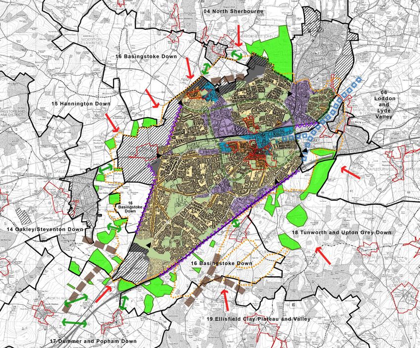
16. Basingstoke Down page 114 have been added for each Character Area. The updated Area Character Areas are mapped and
17. Dummer and Popham Down page 118 described in Section 4.
18. Tunworth and Upton Grey Down page 122
19. Ellisfield Clay Plateau and Valley page 126 1.6 Settlement analysis from the 2001 assessment has been updated as appropriate and is included
20. Candover Valley page 130 in Section 5 of this report.
5 Settlements page 134
1. Basingstoke page 136 2 BASINGSTOKE AND DEANE LANDSCAPE OVERVIEW
2. Tadley/Baughurst/Pamber Heath page 144
3. Chineham page 148 2.1 The Borough of Basingstoke and Deane is a predominantly rural, agricultural district which
4. Oakley page 152 covers a land area of some 245 square miles of north-east Hampshire, shown by Figure 1.
5. Whitchurch page 156 It embraces a diverse pattern of landscapes, including rolling chalk downland, pastoral river
6. Overton page 162 valleys, historic parkland, remnants of ancient forests and intimate mosaics of lowland farmland
7. Kingsclere page 168 and woodland, with a scattering of farms, villages and hamlets, and a few larger settlements,
8. Old Basing page 174 including Basingstoke.
9. Bramley and Bramley Green page 178
2.2 This patterning is the product of the interaction between the physical structure of the landscape
and the nature of the vegetation and land uses that cover it. To understand what makes places
distinctive, it is helpful to summarise the main formative influences - both physical and human -
that have shaped the Borough’s landscape over time.
Physical influences
2.3 The basic structure of any landscape is formed by its underlying rocks and relief. Geology, and
the processes of weathering, erosion and deposition, influence the form of the landscape, its
drainage and soils. In turn, the patterns of vegetation, land use and, to a degree, the location and
form of settlements, are affected.
ii Basingstoke and Deane Landscape Character Assessment 2021 Basingstoke and Deane Landscape Character Assessment 2021 1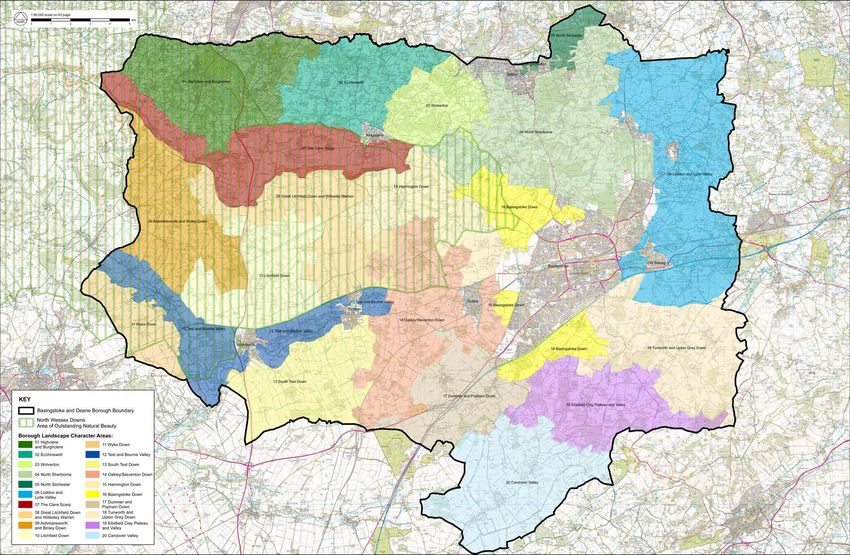
Figure 1 Basingstoke and Deane                                             Based on mapping data licensed from Ordnance Survey, Crown copyright.

2   Basingstoke and Deane Landscape Character Assessment 2021   Basingstoke and Deane Landscape Character Assessment 2021                              3
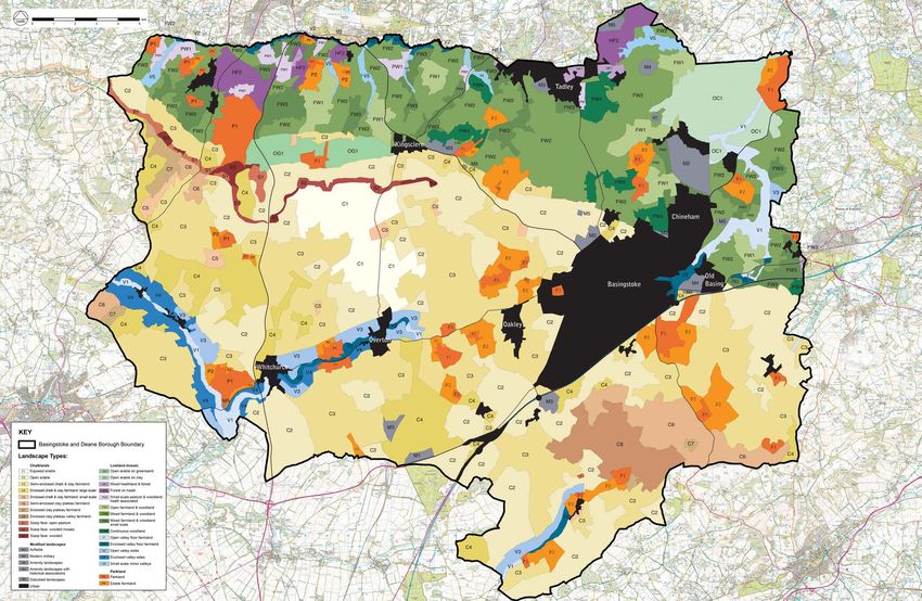
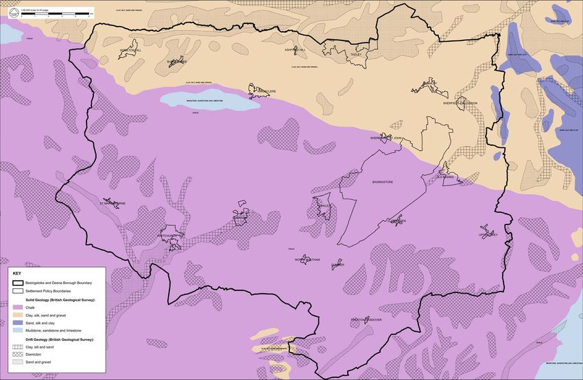
Figure 2 Geology                                                           Based on mapping data licensed from Ordnance Survey, Crown copyright.

4   Basingstoke and Deane Landscape Character Assessment 2021   Basingstoke and Deane Landscape Character Assessment 2021                              5
Geology and landform 2.12 Further north in the Borough, a line of springs arises at the junction of the chalk and the
2.4 The Borough of Basingstoke and Deane lies across the boundary of two distinct geological impervious clays of the lowlands. This produces a complex drainage network, which contrasts
formations, producing a comparatively varied geological structure that has a strong influence markedly with the chalk areas to the south. Many of these numerous springs form tributaries of
upon landform and landscape character (see Figure 2). the River Enborne which flows east-west along the northern boundary of the Borough. Others
form the source and tributaries of the Loddon and Lyde Rivers which flow northwards across the
2.5 The southern part of the Borough is dominated by the deep chalk bed of the North Downs, laid Tertiary deposits of the Thames Basin. The lowest point within the Borough lies at 49 metres,
down in the Cretaceous period when this part of England lay beneath a vast, shallow and warm adjacent to the River Loddon where it crosses the boundary into Wokingham District.
inlet of the sea. This belt of chalk stretches right across Hampshire and its neighbouring counties
of Wiltshire and Sussex, forming the distinctive downland landscapes of southern England. Soils and agricultural land capacity
2.13 A variety of soil types occur across the Borough and influence the capability of the land to support
2.6 The chalk layer has been tilted to form a ridge and eroded on its exposed northern face to create agriculture. Soils on the chalk tend to be well-drained and highly calcareous and are dominated
the distinctive, steep escarpment west of Kingsclere that is composed of the comparatively hard by brown earths on the higher ground of the downs. These soils are often intensively farmed,
rocks of the Middle Chalk. The escarpment is the most prominent topographical feature within but relief and soil depth are limiting factors. The shallow soils of the steeper slopes are less
the Borough and includes the highest point of land at Dean Hill near East Woodhay. Immediately suitable for cultivation and are often wooded, colonised by scrub or under permanent pasture.
below the scarp, erosion has also exposed a narrow belt of Reading Beds and Upper Greensand Agricultural quality on the chalk is predominantly Grade 3 with localised pockets of Grade 2 to
which run parallel to the scarp face. the east and west of Basingstoke.
2.7 From its northern escarpment, the bed of Upper Chalk dips southwards, forming the 2.14 Soils on the Upper Greensand (a variety of greyish white sandstone) to the north of the scarp
characteristically smoothly rolling downland, broad plateaux and shallow valleys that are are typically well- drained, light and loamy. This predominantly Grade 3 quality agricultural land
distinctive features of chalk scenery. Much of the Upper Chalk is overlain by superficial deposits supports an open arable landscape.
of clay with flints, laid down during the inter-glacial period, particularly on the plateau in the
vicinity of Ellisfield and Herriard. This clay cap masks the chalk geology and gives rise to different 2.15 The more complex geology of the London Basin gives rise to a similarly mixed pattern of soils and
soils and surface conditions, often less suited to intensive agriculture and typically clothed in agricultural land value. Areas which are underlain by London Clay typically comprise seasonally
broadleaved woodland. waterlogged fine, silty or loamy soils over clay. These are mostly of Grade 3 quality and support
a mixture of pasture and arable crops. However, poor drainage is a limiting factor and gives rise
2.8 The northern part of the Borough lies on the south- western edge of the London Basin, where to less productive, heavy soils that are mostly under wood- land or, occasionally, lowland heath
the chalk strata dip towards the north and are buried beneath the younger deposits of sands and vegetation. Other gleyed soils occur along the main river valleys where the fine, silty and loamy
clays laid down during the Tertiary period during progressive periods of marine flooding. soils are variously affected by groundwater and subject to flooding, reducing their agricultural
quality to Grade 4.
2.9 These consist of three main geological deposits: London Clay in the east, which is overlain by
Bagshot Beds and Bracklesham Beds (sands) in the west. These deposits are all comparatively 2.16 A deep peaty calcareous soil occurs in the flood plains of the River Test, south of Whitchurch,
soft and are easily eroded to form low-lying landscapes of subdued relief. However, their and in the Loddon and Lyde valleys south of Sherfield. This is a nationally uncommon type of
variability and sequence of outcrops has produced a complex pattern of soils, vegetation types soil and, in the case of the Loddon and Lyde valleys, is the only example occurring within the
and land use character across the area. Thames Basin.
2.10 Later Quaternary deposits of river and valley gravels occur along the main river valleys and 2.17 Well-drained and very acidic sandy soils occur above the High Level Terrace Drift Deposits
deposits of alluvium also follow the outlines of the complex river network. Locally, there are also found at Silchester, Burghclere and Newtown, whilst well-drained gravelly soils are associated
quite extensive High Level Terrace Drift Deposits (plateau gravels), such as those found in the with the area in the vicinity of Mortimer West End. Areas of forest and remnant heath- land are
vicinity of Silchester and Tadley and north of Highclere and Burghclere. characteristic of the thin acid soils.
Drainage
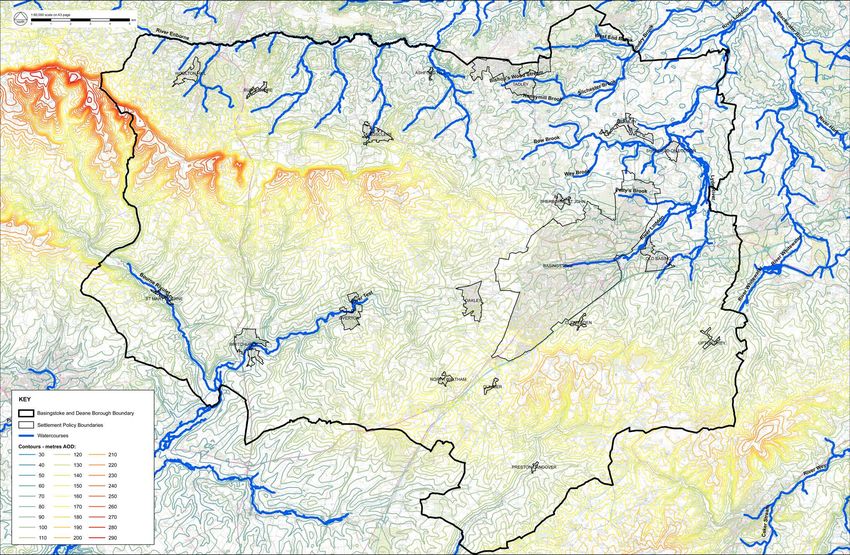
2.11 The chalk dip slope is dissected by dry valleys of river systems that were formed immediately
after the Ice Ages when the chalk would have been frozen at depth and thus impermeable and
able to support streams of meltwater from the ice sheets further north (see Figure 3). These have
long since disappeared and the porosity of the chalk means that rivers and streams are now
comparatively rare. The main exception is the River Test with its tributary, the Bourne Rivulet,
which is a nationally famous chalk river and arises near Ashe to the east of Overton. The river
flows southwards, dissecting the chalk dipslope, and eventually reaches the Solent. Its clear
alkaline water supports salmon and trout fishing and watercress beds.
6 Basingstoke and Deane Landscape Character Assessment 2021 Basingstoke and Deane Landscape Character Assessment 2021 7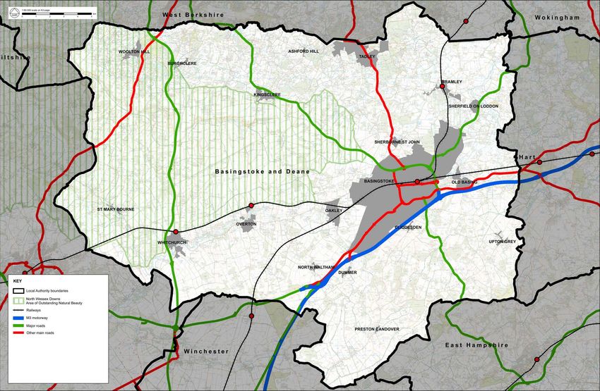
Figure 3 Landform and Drainage                                             Based on mapping data licensed from Ordnance Survey, Crown copyright.

8   Basingstoke and Deane Landscape Character Assessment 2021   Basingstoke and Deane Landscape Character Assessment 2021                              9
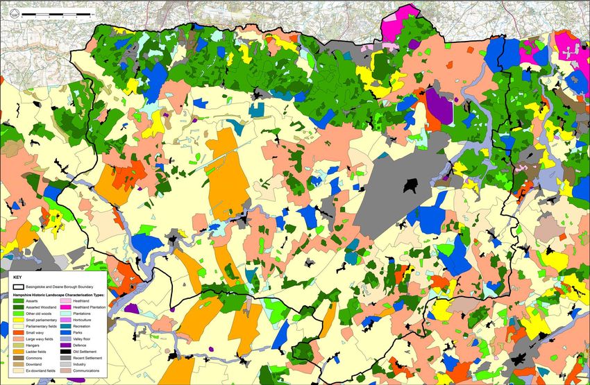
Figure 4 Trees and Woodland                                               Based on mapping data licensed from Ordnance Survey, Crown copyright.

10   Basingstoke and Deane Landscape Character Assessment 2021   Basingstoke and Deane Landscape Character Assessment 2021                             11
Ecology and vegetation                                                                               2.24   There are more visible monumental reminders of the Bronze Age (2400-700 BC) occupants of
     2.18    The distribution of vegetation across the Borough is strongly associated with the area’s geology,           the Borough – although, once again, the evidence for settlements is limit- ed to below ground
             soils and land use over time. As Figure 4 indicates, the Borough is well- wooded, predominantly             features and artefacts. The monuments are predominantly round barrows - burial mounds that
             by broadleafed woodland, with a relatively small number of coniferous plantations. Much of the              may be found singly, or as groups known as barrow cemeteries. Round barrows are Hampshire’s
             broadleafed woodland is ancient and constitutes an important semi-natural habitat. Similarly,               most commonly pre- served type of prehistoric monument. Examples include Seven Barrows
             the 160ha of scattered heathland remnants, plus the fragments of species rich chalk downland,               near Burghclere. During the Bronze Age, forest clearance continued, and this led to the opening
             remnant fen and water meadows, are all important sites of biodiversity. In many cases, this has             up of large tracts of land. Complex patterns of land use were established. There is evidence of
             been recognised through international, national, or local designations.                                     the use of fields from the chalk downlands. This includes remnant field systems visible on aerial
                                                                                                                         photographs and occasionally lynchets (earthworks formed by soil building up against field
     2.19    At the international level, the influence of the Thames Basin Heaths Special Protection Area,               boundaries). Most of the people appear to have lived in small, enclosed farmsteads amongst
             extends into the north-east corner of the Borough. Of national interest are the Borough’s Sites             the fields. The remnants of long deep linear ditches (which probably identified land divisions)
             of Special Scientific Interest (SSSIs), namely areas which are judged by Natural England to be              have been recorded, for example at Ladle Hill.
             of outstanding ecological importance. Many of the SSSIs are associated with the relic chalk
             grasslands and their wild plant communties; others with areas of chalk arable, important for         2.25   It was probably due to the acid nature of clay with flint soils that they were not preferred for
             ground nesting birds. Two other major categories of habitats that have been designated SSSIs                Bronze Age agriculture. Within the Borough, woodland would appear to have persisted on some
             are the Borough’s ancient wood- lands and its unimproved meadows. In terms of distribution,                 of the soils whose acidity was difficult   to remedy in prehistoric times. It is believed that it was
             the largest SSSIs are in the northern half of the Borough, notably Pamber Forest and Silchester             during the Bronze Age that the heathlands in the north of the Borough began to be formed. Due
             Common near Tadley, Highclere Park, and numerous sites along the escarpment. The valleys of                 to pressure for resources on the lighter soils of the downland slopes, new areas were utilised
             the two main rivers are another rich source of SSSIs.                                                       for arable agriculture. The over- exploitation of areas of poorer soil led to a relatively rapid
                                                                                                                         deterioration in soil fertility and, subsequently, in the types of vegetation they could support. The
     2.20    In addition, the Borough contains numerous Sites of Importance for Nature (SINCs) designations              resulting vegetation could, however, be utilised for grazing by animals, and therefore gained
             which protects semi-natural vegetation habitats of scarce and rare species. They are distributed            some value, often as part of common or wasteland. The creation of the later Royal Hunting
             throughout the Borough, the most famous example being the scarp chalk downland site of                      Forests preserved some areas of heathland.
             Watership Down which supports a rich chalk flora.
                                                                                                                  2.26   The processes, which had begun during earlier prehistoric periods, continued and intensified
             Human influences                                                                                            during the Iron Age (700 BC-AD 43). A tribal social structure that may have been emerging
             Prehistoric influences                                                                                      earlier appears to have become well established. Territories could be defended from hill forts
     2.21    The earliest inhabitants of the Borough, during the Palaeolithic period (500,000-10,000 BC),                such as Beacon Hill, Winklebury, and Ladle Hill, around which were field systems and other
             left no visible reminders of their presence. Flint implements recovered from the river valleys              managed landscapes, such as pasture fields. Prehistoric trackways such as The Harrow Way
             and from the chalk downlands around Basingstoke do show that humans were there, at least                    (which runs to the north of Whitchurch), can still be found in the landscape. Long-term occupation
             periodically, probably in low numbers. They lived in a harsh climate and probably survived by               of settlements is indicated in the archaeological record, and the Borough has produced a wealth
             following and preying on herds of game. As the ice retreated due to the climate change (the end             of such sites including Battle Down Farm. The principal local tribe was the Atribatae and their
             of the Ice Age), there was a gradual spread of forest cover over much of the area.                          oppidum (a large permanent settlement) became the focus of Roman administration in the area
                                                                                                                         with the founding of Silchester (Calleva Atrebatum) on the site.
     2.22    There are indications that the process whereby the landscape we recognise today was altered
             and created by human influence was underway during the Mesolithic period (8500-4000 BC).                    Roman influences
             The human population probably began to open up small clearings amongst the tree cover. Again,        2.27   The Roman conquest of AD 43 brought some changes reflecting the new centralised
             there are no visible monuments associated with this low density population who appear to have led           administration, although there was much continuity from the earlier period. An infrastructure of
             a nomadic lifestyle, exploiting natural resources through hunting and gathering. Concentrations             roads was laid down - the lines of many still exist to this day. These include roads from Silchester
             of stone implements show that certain particular locations and types of environment (particularly           to London (The Devil’s Causeway), to Old Sarum and to Winchester. The latter still marks the
             those rich in natural resources) were favoured for repeated visits or longer occupation.                    western extent of Basingstoke.

     2.23    During the Neolithic period (4000-2400 BC) forest clearance continued and was expanded,              2.28   The Roman town of Silchester has been preserved to a remarkable extent because the site was
             as the gradual adoption of a more settled way of life, supported by agriculture and domestic                abandoned following the withdrawal of the Roman army. Standing Roman walls are rarely visible
             animals, allowed larger and more sedentary population groups to emerge. The lighter soils                   as landscape features in Britain but may be seen at Silchester. There was a concentration of
             of the chalk downlands appear to have been preferred locations for occupation. Although the                 Roman villas around the former town, although today they are preserved only as below-ground
             domestic sites of this period are largely invisible in the landscape of today and are recorded in           features. The villas appear to have functioned as administrative centres for the large agricultural
             limited numbers through excavation, there is evidence of a more monumental nature, which                    estates into which much of the landscape was divided. Cultivation of heavier soils was enabled
             does remain visible, although much altered by time. In the Borough, the monuments are limited               by the introduction of new agricultural methods and implements, allowing areas other than the
             to a very small number of long barrows, i.e. burial mounds, often deliberately sited to be visible          light chalk soils of the downlands to be utilised.
             from a considerable distance. One example is a long barrow at Woodcott.

12   Basingstoke and Deane Landscape Character Assessment 2021                                                                                                          Basingstoke and Deane Landscape Character Assessment 2021   13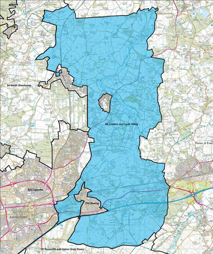
Anglo-Saxon influences                                                                                        Basingstoke. Hamlets, which probably started as single farms, were common, except on the
     2.29    It is likely that the location of many of today’s hamlets and villages was established during                 central chalk downs.
             the Anglo-Saxon (410- 1066) and early medieval periods (c.11th-12th centuries). The preferred
             types of structures built, and continuity of occupation, means that archaeological evidence for        2.34   Close to settlements, the downlands in the earlier medieval period were, as before, probably
             settlement can be difficult to find. There are relatively few visible remnants of the Anglo-Saxon             mainly exploited for arable agriculture. Much of this was based on a system, whereby each
             era to be seen in the land- scape today, although some settlements are named in documents                     ‘village was surrounded by two or three large open and unhedged fields, divided into a multitude
             (mainly Charters) from this time (for example, Whitchurch). Churches were a feature of the                    of strips, all individually owned but farmed in common’. Sheep and cows were also grazed on
             period and some existing later churches may have been built on the site of, or retain elements                downland pasture. Small irregular clearances (known as ‘assarts’) of wood- land, heathland
             from, an earlier (Saxon or medieval) church. Possible examples are Old Basing and Whitchurch.                 or common for private grazing or arable production were seen from the 13th-16th centuries.
             Similarly, the historic core of some settlements may date back to this period. There is also some             Small- scale enclosures (encroachments) – often worked by land- less labourers, became more
             limited documentary evidence from the period.                                                                 common on the poorer soils of forests and heaths, as royal interest in forests waned. There
                                                                                                                           was also some enclosure by agreement at this time. During the medieval period there were
     2.30    Many large estates are known to have become well-established from this time. For example, it                  fluctuations in the population size as epidemics of the plague and a decline in arable farming
             is likely that (Old) Basing was an important royal estate in mid-Saxon times. Forest clearance is             combined to produce abandoned or shrunken settlements. Shrunken villages may have been
             likely to have continued throughout the Anglo-Saxon period.                                                   reduced to earthworks or cropmarks and have consequently been ‘lost’. Others may be known
                                                                                                                           from remnant buildings, such as churches, left in an apparently empty land- scape, or through
     2.31    The Domesday survey of 1086 provides an insight into how parts of the English landscape                       place-name or cartographic evidence. There are many examples in the Borough, including
             were organised just before and after the Norman Conquest of AD 1066. Important landowners,                    Hatch on the eastern edge of Basingstoke, Old Burghclere and Newtown at the extreme north
             particularly the King and the Church, controlled large parts of the countryside either directly or            of the Borough. Emparking was one major cause of villages being lost or moved. Another factor
             indirectly. A number of the settlements within the Borough were mentioned in the Domesday                     may have been the reduction of the water table on the chalk which may have caused some
             Survey (for example Baughurst, Overton, Old Basing, and Whitchurch). Although pasture and                     former ‘rivers’ to become ‘winterbournes’ only (there are some shrunken or deserted settlements
             sheep are not generally mentioned in the Hampshire Domesday it is probable that they were of                  on higher chalk).
             economic importance to many settlements even at this time.
                                                                                                                    2.35   The increased pace of enclosure of the open fields was a principal change in the post-medieval
             The influence of the medieval period                                                                          period. In some places the open fields began to be enclosed either by agreement or piecemeal.
     2.32    During the medieval period (1066-1499) the Royal Forests of Pamber and of Eversley were                       One major influence was the continued growth of the importance of sheep farming – particularly
             established at the northern edge of the Borough. The term Royal Forest refers not to a wooded                 on the chalk downlands. The profitability of sheep for the production of wool peaked in the
             area but to an area subject to special Forest Law and used for hunting. Pamber Forest was                     sixteenth century. Overproduction lead to a general collapse in wool prices at the end of the
             located in a less fertile area, as were other Hampshire Forests. Research has shown that                      sixteenth century. However, the number of sheep in Hampshire remained high, as the sheep-
             clearance occurred within these Forests. Deer Parks were also established during this period                  wheat link became a more developed and specialised agricultural system.
             and banks and ditches (pales) which surrounded such parks have been preserved as visible
             earthworks in a number of places such as the Great Park at Weston Patrick. The Bishop of                      The influence of the post-medieval period
             Winchester was a powerful landowner in Hampshire and his numerous residences generally                 2.36   In the 17th and 18th centuries social and economic changes, combined with developments
             had a Deer Park attached to them. The 13th and 14th century landscapes within such parks                      in agricultural practices, began to lead to changes in the landscape. There was a growth in
             were the product of careful management techniques, including exploitation of timber coppicing                 arable agriculture on the former down- lands. The thin, low nutrient soils of these areas could
             and the maintenance of meadows for fodder. Despite the fact that many bishopric parks were                    be exhausted rapidly by arable agriculture, if steps were not taken to maintain them. It was
             disparked in the 16th and 17th centuries, a number of such parks have been pre- served within                 recognised that enclosing sheep in folds improved the soil fertility. This led to the enclosure
             later (often larger) parklands landscaped for great houses (for example at Highclere).                        of open downland, in order to control grazing more efficiently. An increased use of root crops
                                                                                                                           (mainly as fodder for sheep) resulted in more sheep and thus more manure, whilst growing
     2.33    Defensive sites, such as Motte and Bailey castles or ring works have also been preserved,                     clover and grass on ‘resting’ arable land also improved fertility. The construction of drainage
             and there is a concentration of these on the clay lands and wooded areas of the north-west of the             systems allowed controlled flooding of water- meadows in the valley bottoms. This important
             Borough - partly coincident with areas of former medieval forest. Examples include Beaurepaire                development provided early spring food for the large numbers of sheep in the 17th and 18th
             House and Sherfield Hall. Moated sites have also been preserved, with a concentration in the                  centuries.
             north-east of the Borough. The Bishop of Winchester founded at least two planned ‘new towns’ in
             the Borough in the medieval period (Newtown, and Overton), and Whitchurch was granted town             2.37   In the late 18th and early 19th centuries the process of enclosure was intensified and formalised
             status. Such sites required a flat site, access to water and good communications. They might be               by Acts of Parliament. Hedges became more commonplace as the land was divided into
             founded on the site of, or close to, an existing settlement or on a new site. In terms of transport,          geometrically shaped fields. As agricultural methods, crops and livestock continued to be
             there was an emphasis on east-west routes from London, via Basingstoke, to Salisbury. There                   improved, there was a pressure for wastes, forests and heathlands to be enclosed (not always
             were, however, minor north-south routes through Overton, Hurstbourne Priors and Whitchurch,                   legally), and old woodland continued to be cleared. The pattern of the landscape that emerged
             and the latter was turnpiked in 1762. There was a concentration of medieval settlements around                at this time can still be traced today, although in many areas the hedges which marked the

14   Basingstoke and Deane Landscape Character Assessment 2021                                                                                                          Basingstoke and Deane Landscape Character Assessment 2021   15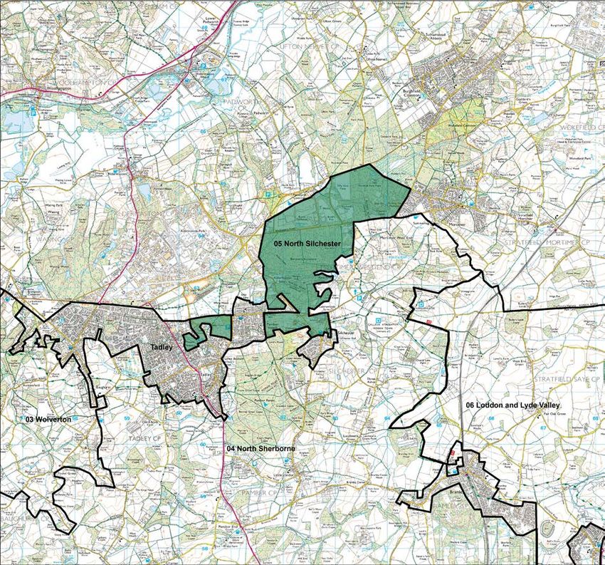
enclosures have since been removed to allow access and working space for large modern                         ▪ Substantial loss of heathland vegetation to agriculture.
             machinery.                                                                                                    ▪ A significant decline in the condition of remnant heath- land and chalk grassland resulting from
                                                                                                                             lack of management and invasion of scrub and woodland.
     2.38    In the Post-medieval period communications improved with the construction of such visible                     ▪ Loss of ponds and wetlands through drainage and ploughing of previously uncultivated land.
             landscape features as turnpike roads, canals (some of which were later infilled but the routes
             may often be traced), and railways. There are many important post-medieval houses and                  2.44   However, in recent years, agricultural subsidies have been gradually designed to encourage
             estates throughout the Borough. Some were based on earlier estates, and may incorporate                       more environmentally friendly farming. The cumulative effect of these scheme is likely to have
             earlier deer parks and/or hunting lodges within more recent designed landscaped gardens or                    a positive impact on the landscape of the Borough. Sensitive management is now being carried
             parkland. Some of these properties, such as Highclere, still sit within their estates and still form          out in many areas, evidenced in the replanting of hedgerows, encouragement of hedgerow
             land- scape entities. Others, for example Basing House, have become largely isolated.                         trees, and generally a more careful use of herbicides and fertilisers in field margins and near
                                                                                                                           watersides.
     2.39    In modern times the landscape has been influenced by a number of factors, including the military
             (for example the complex at Bramley), agricultural practices and wood- land removal. After                    Forestry and woodland
             the Second World War large areas of ancient woodland were removed for agricultural use or              2.45   Approximately 15% of the total area of the Borough is occupied by woodland and copses,
             were replaced with plantations. Extensive ploughing of the downlands and hedgerow removal                     considerably in excess of the national average. Much of this is ancient semi-natural woodland
             continued, encouraged by the post Second World War emphasis on food production. Farm                          of high landscape, nature conservation and historic landscape value. Although there have been
             holdings increased in size and many farmsteads converted to private residences. Large areas of                very significant reductions in the extent of woodland during the twentieth century, census figures
             heathland were also lost after the war, through lack of management and through woodland and                   from the 1990s indicate that woodland cover is now increasing within the Borough, helped by
             bracken encroachment.                                                                                         significant tree planting on estates. The critical issue is the condition of the existing resource,
                                                                                                                           and the re-emergence of traditional management practices such as coppicing needs to be
     2.40    Whilst the rural landscape continues to support and reflect the importance of farming, the                    encouraged. The more sensitive management practices that are being carried out in some
             tremendous growth in the population of the Borough has produced a simultaneous growth                         wooded and agricultural areas, highlight the key role that landowners and farmers continue to
             in housing, industry, shopping and leisure facilities. This growth in the Borough’s towns and                 play in caring for the landscape.
             villages, and the expansion of the road network, including the M3 motorway, further reflects the
             way that human influences have shaped today’s landscape.                                                      Nature conservation
                                                                                                                    2.46   The Borough is a rich area for wildlife, and yet has suffered great losses during the past 200
             Forces for Change                                                                                             years as habitats have been lost to development, or degraded by agricultural practices and
     2.41    The Borough of Basingstoke and Deane is a predominantly rural district with some outstanding                  afforestation. The Hampshire Biodiversity Partnership (embracing a range of organisations) was
             areas of landscape and a high proportion of very attractive, unspoilt country- side. The importance           formed in 1997 to help halt this trend, and to advance the conservation and enhancement of
             of its landscape at a national level is confirmed by the designation of approximately one third               biodiversity in the county. To this end, it has set out a ‘Biodiversity Action Plan for Hampshire’
             of the countryside of the Borough within the North Wessex Downs Area of Outstanding Natural                   which, in addition to describing the county’s biodiversity, identifies habitats and species of priority
             Beauty.                                                                                                       concern and proposes a framework for action. By establishing working groups to implement
                                                                                                                           detailed action plans, it is hoped that the biodiversity value of the Borough will be conserved
     2.42    The landscape has undergone considerable changes over time, as a result of a variety of different             and enhanced for future generations. The work already being carried out by some farmers and
             forces. Historically, changes in agricultural practice and socio-economic activity affecting the              landowners to raise biodiversity levels on intensively farmed land offers encouragement for the
             landscape have been comparatively gradual but, during much of the 20th century, the pace of                   future.
             change increased. Much of this change has had a negative impact on the landscape, but more
             positive trends are emerging. This section briefly examines the principal forces for change that              Urban expansion, traffic and development issues
             have affected the landscape, historic and ecological resources of the Borough and are likely to        2.47   In common with much of southern England, the Borough has experienced significant expansion
             influence its character in the future.                                                                        of urban areas, particularly Basingstoke. The pressure for further growth of towns and villages
                                                                                                                           continues apace. Apart from the loss of open countryside to development, the landscape may
             Agriculture                                                                                                   suffer from urbanising influences on adjacent rural areas, including the effects of new recreational
     2.43    Post-war agricultural change has had a significant impact on the character of the countryside,                activities, and additional traffic on rural roads and lanes. These impacts are already evident
             with widespread intensification of agriculture causing a dramatic reduction in the extent of                  in the landscape around the edges of Basingstoke, and many villages and lanes within the
             hedgerows, trees, species-rich grasslands and many other semi-natural wildlife habitats and                   Borough suffer from traffic levels which they were not designed to cope with. This can result in
             landscape features. These impacts have had a significant effect on the Borough's landscape                    congestion, and in damaged hedge banks or verges where over-large lorries have passed.
             with:
             ▪ Widespread loss of permanent grassland to arable cultivation on the chalklands.                      2.48   New road building and widening has had an impact on the Borough landscape over recent years.
             ▪ Significant losses of hedgerows across the Borough, especially in the east around Stratfield                The landscape immediately adjacent to major road corridors is affected by noise and visual
               Saye.                                                                                                       intrusion (often of associated development such as service areas and lighting), which detracts

16   Basingstoke and Deane Landscape Character Assessment 2021                                                                                                             Basingstoke and Deane Landscape Character Assessment 2021   17
from its rural character and sense of remoteness and tranquillity. Other developments, including 3 LANDSCAPE AND TOWNSCAPE TYPES
in particularly recent trends in energy generation, such as solar farms and wind turbines have
also had an effect. Historic Landscape Types
3.1 The starting point to understanding the character of the Borough’s landscape in an integrated
2.49 More subtle changes resulting from development include the suburbanisation of the countryside way is to understand the distribution of historic landscape types, with The Hampshire Historic
and rural settlements. These arise from the introduction of non-agricultural land uses, such Landscape Characterisation used as the principal framework, verified and amended where
as golf courses, and the gradual erosion of local distinctiveness in built form as traditional necessary through further assessment. The broad categories of those present in Basingstoke
features have been replaced with standard, uncharacteristic alternatives, ornamental planting and Deane are illustrated in Figure 5.
and fencing. Other urbanising influences include unsympathetic road improvements, and the
introduction of intrusive lighting and signage in rural areas. Local distinctiveness has also been Landscape Types
subtly undermined in places by the planting of inappropriate species. One further issue that has 3.2 Historic landscape types can be defined objectively on the basis of archive material, mapping
come to prominence is the need for development to take account of possible increased flood and photographic material. However, in themselves they do not explain landscape character as
risks associated with climate change. experienced on the ground today. This is done through the identification of generic landscape
types which in their appearance reflect both the natural and cultural processes that created
Access to the countryside them.
2.50 The Borough has an excellent network of public footpaths. However, there remains scope for
access to be improved in certain parts of Basingstoke and Deane, particularly enhancing links 3.3 The County-wide assessment produced by Hampshire County Council defines a range of
between built up areas, ensuring that new development does not cut off access to open areas, generic landscape types for the rural areas of Hampshire, divided into two broad groupings:
and to increase public awareness of the many opportunities that exist to walk in the countryside. the chalklands and lowland mosaic. The County-wide assessment identifies a total of ten rural
types within the Borough of Basingstoke and Deane. These were subsequently examined
Variations in landscape character and refined as part of the 1995 Borough-wide assessment, which resulted in the alteration of
2.51 The broad influences and processes of change described above help to explain the overall some boundaries and some sub-division of types, defining thirteen landscape types within the
pattern of landscape elements and character within the Borough. However, this picture needs Borough.
to be simplified if it is to be properly understood and used to inform planning and management
policy. The sorting of landscape resources into units of distinct and recognisable character is 3.4 These landscape types were re-examined as part of the 2001 Basingstoke and Deane Landscape
an important way of achieving this understanding and is now common practice in landscape Assessment and further refinements were made to reflect even more detailed variations in
assessment. local character, particularly the variations in scale of the landscape and in enclosure created
by the structure of hedgerows and woodlands. This resulted in the definition of 30 different
2.52 This study examines variations in character in a number of ways: landscape types across the Borough, although some represent quite subtle variations on a main
▪ By identifying generic historic landscape types or groups of types, which represent distinctive type. Despite this different and more detailed approach to defining local landscape character,
and coherent combinations of historic features, or areas of land- scape with common historic there remains a strong correlation between the landscape types identified within the three
origins. assessments. In defining landscape types, substantial effort was put into ensuring consistency
▪ By defining a number of generic landscape types, which represent distinctive combinations with the landscape types of adjoining local authorities, with consistency achieved in the ‘grain’
of landform and landcover elements that repeat across the Borough, without being related and nature of landscape types.
directly to specific places.
▪ By defining a number of generic townscape types, which represent areas of built form with 3.5 This 2021 update of the Basingstoke and Deane Landscape Character Assessment retains
distinctive townscape and often historic characteristics. the landscape types of the 2001 assessment as set out below, and illustrated on Figure 6. It
▪ By integrated character areas, representing larger tracts of rural or urban landscape, which is important to emphasise that the ‘grain’ of characterisation within a district-wide assessment
have a coherent and recognisable local identity or sense of place, derived from distinctive is too coarse to map every localised variation in character that will inevitably occur, especially
combinations of landscape, historic landscape or townscape types and their particular around the edges of settlements.
geographical location and context.
18 Basingstoke and Deane Landscape Character Assessment 2021 Basingstoke and Deane Landscape Character Assessment 2021 19Figure 5 Historic Types Based on mapping data licensed from Ordnance Survey, Crown copyright. 20 Basingstoke and Deane Landscape Character Assessment 2021 Basingstoke and Deane Landscape Character Assessment 2021 21
Figure 6 Landscape Types                                                   Based on mapping data licensed from Ordnance Survey, Crown copyright.

22   Basingstoke and Deane Landscape Character Assessment 2021   Basingstoke and Deane Landscape Character Assessment 2021                              23
Open arable landscapes                                                                               3.9    The 1995 Borough assessment distinguishes between the clay plateau landscapes on areas
     3.6     These are the extensive, large-scale and open arable landscapes that are characteristic of the              of different topography, notably between the flatter areas of continuous clay, and the series of
             most intensively farmed chalkland areas. They are widespread across the Borough, particularly               ridges and valleys where erosion has worn away much of the clay. These differences have also
             in those areas of gently rolling landform where the influence of the chalk geology is not masked            been defined in this assessment, together with a distinction in the degree of enclosure within the
             by deposits of clay with flints. Like the 1995 Borough-wide assessment, this assessment divides             flatter clay plateau areas:
             the main open arable landscape type into two sub-types, mainly reflecting differences in the                ▪ Semi-enclosed clay plateau farmland (C6) - predominantly large-scale arable fields with
             frequency of hedgerows and trees. These are:                                                                   some areas of pasture; high frequency of woodland (predominantly semi-natural broadleaved)
             ▪ Exposed arable (C1) - very large-scale, arable fields with virtually no structure of hedgerows,              and a strong structure of hedgerows with distinctive oak trees; some visual containment and
                trees or woodlands; simple landscape with few landscape features; visually exposed with a                   enclosure by vegetation or landform, but the scale of field pattern allows more distant views
                sense of elevation and extensive panoramic views; blocks or belts of plantation woodland                    and creates a semi-enclosed character; settlements infrequent and occasional hamlets are
                may be present but are generally infrequent; scattered settlement pattern dominated by large                widely dispersed and linked via a network of narrow and indirect lanes, lending a sense of
                farms.                                                                                                      remoteness to the area.
             ▪ Open arable (C2) - similar characteristics to C1 but distinguished from that type by a                    ▪ Enclosed clay plateau farmland (C7) - as C6 but with a stronger sense of enclosure created
                greater frequency of hedgerows defining field boundaries. However, these are often low and                  by vegetation cover. Enclosed clay plateau valley farmland (C8) - distinguished from C6 and C7
                fragmented with few hedgerow trees, and there is still a low incidence of woodland cover;                   by topography, with a complex system of steep-sided, enclosed valleys and ridges contrasting
                settlements scattered and infrequent but occurring more often than in the exposed arable type.              with flatter plateau landscapes; steep slopes, often wooded, and dense hedgerows and
                                                                                                                            blocks of woodland also occurring on upper slopes; visual enclosure provided by landform
             Chalk and clay landscapes                                                                                      and vegetation, creating an intimate land- scape; occasional hamlets and villages with narrow
     3.7     These landscapes are the most extensive in the Borough and are typical of chalkland areas                      lanes running along valley floor and then upwards onto clay plateau.
             where there are widespread deposits of clay with flints, particularly on hilltops, creating an
             undulating or rolling landform. These landscapes share some of the characteristics of the open              Scarp landscapes
             arable landscapes, but the main difference is the greater incidence of woodland, hedgerows           3.10   These are areas of dramatic landform at the edge of the chalk, where erosion has exposed
             and tree cover. This is closely related to the presence of clay on the ridges and hilltops and              the hard Middle Chalk to form a steep, north facing slope. This towers above the lower-lying
             its absence in the valleys. Three main subdivisions of this type have been identified in this               landscapes to the north and forms a dramatic edge to the long gentle gradient of the dipslope
             assessment on the basis of the degree of enclosure created by differences in landform and                   stretching away to the south. At certain places, such as Beacon Hill, the scarp encircles an area
             vegetation cover and the scale of the landscape. These are:                                                 of high ground, producing a domed hill, flanked by characteristic steep-sided coombes. The
             ▪ Semi-enclosed chalk and clay farmland (C3) - predominantly large-medium scale arable                      main distinctions in character brought out by this assessment relate to differences in land cover
                fields with some areas of pasture; frequent woodland blocks and an intact structure of                   along the steep scarp face, as follows:
                hedgerows; some visual containment and enclosure by vegetation or landform, but scale                    ▪ Scarp face: open pasture (S1) - steep, generally north-facing slope predominantly under
                of field pattern allows more distant views and creates a semi-enclosed character; denser                   permanent pasture, with areas of remnant chalk grassland; possibly some encroaching scrub
                settlement pattern than found on open arable landscapes with scattered hamlets and villages                but generally open in character with extensive views out across landscape to the north;
                linked with a moderately dense network of generally winding lanes;                                       ▪ Scarp face: wooded mosaic (S2) - areas of steep scarp face, which have developed a
             ▪ Enclosed chalk and clay farmland: large-scale (C4) - as C3 but with frequent woodland and                   mosaic of grassland, scrub and woodland;
                strong, often tree lined, structure of hedgerows, which creates a definite sense of enclosure            ▪ Scarp face: wooded (S3) - areas of steep scarp face, which are clothed in dense woodland.
                and contains more distant views;
             ▪ Enclosed chalk and clay farmland: small-scale (C5) - similar to C4 but with a noticeably                  Open arable on Greensand
                smaller-scale of landscape pattern resulting from smaller field sizes, more diverse topography    3.11   This landscape type occurs in a single location at the foot of the steep chalk scarp to the
                and a more intimate patchwork of hedgerows, woods and open fields.                                       west of Kingsclere, associated with an exposure of Upper Greensand. It shares many of the
                                                                                                                         characteristics of the surrounding chalk landscapes and almost imperceptibly merges with them,
             Clay plateau landscapes                                                                                     forming a smoothly undulating landform. This is characterised by large-scale, open arable fields,
     3.8     These are landscapes which typically occur on areas of higher ground underlain by extensive,                with sparse, closely trimmed hedges and occasionally interrupted by hedgerow trees and blocks
             sometimes almost continuous, deposits of clay with flints. The best example is Herriard Plateau in          of woodland. This is a fairly homogenous area of landscape character which is identified as a
             the south-eastern part of the Borough. Other examples are found in the Oakley/Hannington area               single type in this assessment:
             and in places towards the far western boundary of the Borough. A denser pattern of vegetation               ▪ Open arable on Greensand (OG1) – strongly undulating landform forming a transitional area
             distinguishes these areas from the adjacent chalk uplands, with a high overall cover of woodland              between the steep chalk scarp and low-lying clay landscape to the north; predominantly
             (typically semi-natural broadleaved) and a strong structure of dense, mixed species hedgerows,                under arable cultivation with large scale fields divided by sparse, trimmed hedgerows; isolated
             with oak as a predominant species.                                                                            hedgerow trees and occasional woodland blocks; generally open character with distant views;
                                                                                                                           settlements infrequent or scattered and consisting of large farms and associated buildings
                                                                                                                           (including stud farm); roads infrequent and normally follow a gently winding route.

24   Basingstoke and Deane Landscape Character Assessment 2021                                                                                                        Basingstoke and Deane Landscape Character Assessment 2021   25
Open arable on clay of neutral or calcareous soils, such as oak, ash, field maple, dogwood etc. Fields tend to be
3.12 This landscape type is only found in the Loddon and Lyde Valley character area and is unique irregular in shape and bounded by thick hedgerows, mature trees and blocks of woodland,
to the Borough. It is a flat, low-lying landscape associated with the River Loddon, although there creating a strong sense of enclosure and intimacy. The complex pattern of small-scale valleys,
is little discernible valley form. It overlies extensive deposits of London Clay with soils prone to which cross this area from the edge of the chalk to the River Enborne, add to this diversity
waterlogging. Drainage ditches are frequent features. The landscape is generally open, with low, and enclosure. Some areas have a larger-scale pattern of farmland and are less enclosed by
trimmed hedges containing isolated mature trees, and only a few isolated copses of oak and ash woodland. This assessment sub-divides this type on the following basis:
woodland are interspersed across the landscape. This is a fairly homogenous area of landscape ▪ Open farmland and woodland (FW1) - large-scale, often regularly shaped fields,
character which is identified as a single type in this assessment: predominantly under arable; hedgerow structure and woodland blocks are present, but much
▪ Open arable on clay (OC1) - flat, low-lying landscape; predominantly under arable cultivation less frequent or strong than in other examples of this type; generally open character, although
with medium to large-scale fields; isolated copses of woodland and low, trimmed hedges with longer distance views interrupted by vegetation;
isolated hedgerow trees; frequent drainage ditches; generally open character with medium ▪ Mixed farmland and woodland: large-scale (FW2) - medium to large-scale mosaic of
range views interrupted only by the layering effect of sparse vegetation in flat landscape; predominantly arable farmland and woodland; strong hedgerow structure creates moderate
outside the main villages settlement pattern very sparse, with larger farms or small clusters of sense of enclosure;
cottages located at the junction of narrow lanes. ▪ Mixed farmland and woodland: small-scale (FW3) - small-scale mosaic of mainly pasture
and woodland; strong tree cover and hedgerow structure; enclosed, intimate character;
Heathland and forest landscapes complex landscape created by diverse vegetation pattern and small-scale pattern of valleys;
3.13 These landscapes occur exclusively within the north of the Borough on the mosaic of Tertiary ▪ Continuous woodland (FW4) – large uninterrupted areas of predominantly broadleafed
clays, sands and gravels with thin acidic soils. They represent areas of unproductive land that woodland.
have escaped conversion to agricultural use, and comprise a mosaic of acid grassland, heath,
encroaching scrub and trees (birch, pine and oak) or continuous forest, mostly comprising River valley landscapes
coniferous plantations. They represent important remnants of formerly more extensive areas of 3.16 River valley landscapes have been identified where they have a distinctive, sharply defined
these habitats and are highly distinctive landscapes within a predominantly farmed area. This valley form or riparian character, notably the chalk rivers of the Test and Bourne Rivulet. The
assessment sub-divides this type into two, reflecting the difference between more open mosaics Hampshire County assessment and the 1995 Borough assessment tend only to identify the
of heathland, scrub and woodland, and the dense continuous stands of forest: distinctive landscape characteristics of the valley floor. These include flat, low-lying farmland,
▪ Mixed heathland and forest (HF1) - areas or heathland vegetation forming a mosaic with predominantly under pasture, with characteristic waterside tree species such as willow and alder
invading scrub, grassland and woodland; semi-natural character; generally visually enclosed running alongside the river and other water- courses. The valley floor includes areas of meadow
but with a mosaic of more open and enclosed areas; grass- land and other wetland habitats, and watercress beds are fed by braided river channels.
▪ Forest on heath (HF2) - large-scale areas of continuous woodland or forest cover; mainly
under commercial coniferous plantations, but with some fringes or stands of broadleaved 3.17 In the 2001 assessment, a number of additional types were identified to include the prominent,
woodland; potentially some open areas created within the forest through management. sloping valley sides of the main rivers (particularly on the chalk), and those examples of minor
tributary valleys that have a distinctive v-shaped form. Land within river valleys which does not
Pasture and woodland: heath associated landscapes display any special characteristics and merges imperceptibly with the surrounding landscape
3.14 This landscape type is also confined to the Tertiary sand, gravel and clay deposits along the (eg along the Loddon and Lyde rivers) has been included within the adjacent landscape type.
northern edge of the Borough on acid soils. It essentially comprises a small scale, intimate The main distinctions are:
mosaic of grazing land and woodland and is very similar to the mixed farmland and woodland ▪ Open valley floor farmland (V1) - flat, low-lying farmland on the valley floor, mainly under
types. However, it differs in the predominance of pasture over arable or mixed farmland and, grazed pasture or meadow grassland but with occasional arable; distinctive pastoral and
most importantly, in the clear presence of heathland species within verges, woodlands and riparian character and distinctive species of alder and willow along watercourses; hedgerows,
hedgerows (eg bracken, gorse, oak and birch) which are indicative of more acid soils and a trees and woods comparatively sparse, creating a more open character along the valley floor;
former heath- land character. This type has not been sub-divided in this assessment: ▪ Enclosed valley floor farmland (V2) - similar to V1 but with a greater frequency of trees,
▪ Small-scale pasture and woodland: heath associated (PW1) - mosaic of small-scale hedgerows and woodlands and a smaller-scale pattern of farmland, creating a stronger sense
irregular, fields, predominantly under pasture, and abundant blocks of woodland (coniferous, of enclosure;
mixed or deciduous); frequent hedgerows and hedgerow trees (oak); heathy vegetation ▪ Open valley sides (V3) - steeply-sloping land which forms an integral part of the valley
characteristics within woodlands, hedgerows, field margins and verges (e.g. oak, birch, gorse, landscape; fields of varying sizes under arable or pasture with a weak structure of hedgerows
bracken, pine); complex structure and intimate, enclosed character. and trees; predominantly open character along valley sides although landform blocks views
to wider areas;
Mixed farmland and woodland landscapes ▪ Enclosed valley sides (V4) - as V3 but with a stronger structure of hedgerows, tree and
3.15 These represent the most extensive landscape types across the northern part of the Borough woodland along the valley sides, creating a stronger sense of enclosure within the valley;
and form a distinctive and highly complex mosaic of mixed farmland and woodland of varying ▪ Small-scale minor valleys (V5) - small-scale, distinctive, v-shaped valley landform, without
scales and degrees of enclosure. There are no strongly discernible heathy characteristics to clear definition, between the floodplain and valley sides; tend to be associated with minor
the vegetation. Species common in hedgerows and woods tend towards those more typical tributaries of the main river systems, particularly the River Enborne; generally strong structure
of hedgerows, trees and woods, creating strongly enclosed, intimate landscapes.
26 Basingstoke and Deane Landscape Character Assessment 2021 Basingstoke and Deane Landscape Character Assessment 2021 27Parkland landscapes poor land management and neglect, such as rank grassland and poorly managed boundaries
3.18 These landscapes do not register as distinctive types either within the Hampshire County associated, for example, with horse grazing. Figure 6 illustrates the distribution of all the
assessment or the 1995 Borough assessment, even though they occur quite frequently within the landscape types across the Borough as a whole.
Borough, sometimes cover quite extensive areas, and can have very distinctive characteristics
that set them apart from surrounding rural landscapes. They are typically associated with large Townscape types
country houses and estates where a designed character has been imposed upon the underlying 3.22 Settlements are intimately linked to the landscape of which they are a part. However, within
landscape. They include: settlements there are distinct townscape types that reflect specific patterns of growth and
▪ Parkland (P1) - including grand, designed landscapes and smaller areas of parks and gardens development. Using a combination of historic mapping, historic research and fieldwork, the
associated with large country houses; typical characteristics of grazed pasture with mature principal generic townscape types described below were identified within the Borough.
parkland trees, avenues, copses and clumps of trees, exotic planting and lakes; typically lie
immediately adjacent to large country houses; well-man- aged landscape character; 3.23 The townscape types of the 2001 Basingstoke and Deane Landscape Assessment have been
▪ Estate farmland (P2) - the wider farmed landscape of large country estates which typically retained within this 2021 update, along with an additional type of '21st Century Housing Estates'
forms a setting for the parkland; with a mature, well-managed and well-wooded character to take account of housing development since the 2001 assessment. Each of these types is
(with frequent copses and game coverts); often surrounded by distinctive estate boundaries identified on the updated plans in Section 5.
(railings or ornamental fencing) and avenues of mature trees.
Historic Urban Core:
Modified landscapes ▪ Continuous built street frontages
3.19 These are landscapes that lie within a rural context but have developed semi-urban characteristics ▪ Generally on medieval burgage plots
because of their specific land uses, or proximity to urban influences. They include such disparate ▪ Often a central focal point or landmark
landscapes as golf courses, quarries, landfill sites and airfields. The common thread is that their ▪ Buildings using local materials
underlying landscape character has been overwhelmed or even destroyed by specific land uses ▪ Variety of built form – some modern redevelopment
or management regimes, to produce areas of distinctively different character from the areas ▪ Relatively high density
surrounding them. These landscape types are not defined within the County or 1995 Borough ▪ Usually minimum setback from street
landscape assessment, but are defined now follows:
▪ Airfields (M1) - typically flat, open landscapes with distinctive features of sheds, areas of hard Historic Areas with Rural Characteristics:
standing, security fencing etc. However, there is only one small example of this type in the ▪ Generally more open built form
Borough and it is relatively low-key and rural in character; ▪ Houses often in large plots, often with outbuildings
▪ Modern military (M2) - typically enclosed landscape altered for modern military purposes ▪ Buildings of local materials
and relatively inaccessible to the general public. There is one large military camp within the ▪ Variety of built form
Borough, at Bramley; ▪ Landscape features form a strong element
▪ Amenity landscapes (M3) - these include golf courses and recreational areas which have ▪ Low density
an intensively managed, suburban character unrelated to their landscape context. They have
large areas of managed grassland and distinctive features of bunkers, planting of non-native Post Medieval – 19th Century Expansion:
fast- growing species, club houses/parking etc. ▪ Mostly 19th century, especially after the arrival of the railways
▪ Amenity landscape-historic associated (M4) - these include areas of historic importance ▪ The link between buildings and local materials is usually weaker – brick is the usual material
which are specifically managed as tourist attractions or recreational areas; ▪ Fairly high density
▪ Disturbed landscapes (M5) - these are areas where the landscape has been physically
altered by mineral or landfill operations, and has lost its original character. Linear 20th Century Expansion:
▪ Ribbon development – access from existing roads
Urban areas and edge characteristics ▪ Often detached houses and bungalows in fairly large plots
3.20 The more extensive areas of continuous built form associated with the main settlements are ▪ Low density
identified in the County and Borough-wide assessments as ‘urban’ landscape types. These have
been further sub-divided, as part of the key settlement studies, into distinctive townscape types. 20th Century Housing Estates:
However, smaller settlements and areas of built form have not been defined separately and, ▪ Development not facing onto an already existing road
therefore, some landscape types may include areas of built form that do not register within the ▪ Access from culs-de-sac or loop roads
landscape type description. ▪ Low-medium density
3.21 Around the edges of settlements, in particular, some of the landscape types described above
exhibit ‘fringe’ characteristics, which alter their underlying character. They are often the result
of the intrusion of adjacent built development, roads or other features (such as power lines), or
28 Basingstoke and Deane Landscape Character Assessment 2021 Basingstoke and Deane Landscape Character Assessment 2021 29You can also read