Maynooth Environs Local Area Plan 2009-2015 April 2009 - Meath County Council
←
→
Page content transcription
If your browser does not render page correctly, please read the page content below
Maynooth Environs
Local Area Plan 2009-2015
April 2009
Maynooth Environs
             Local Area Plan 2009-2015

                                 April 2009

     Prepared by

      Planning, Urban Design, Graphic Design
Contents

1.0 Introduction                                                        1

1.0       Introduction                                                  2
1.1       Need for Plan                                                 2
1.2       Strategic Role of Maynooth                                    2
1.3       Consultation                                                  2
1.4       SEA/AA Screening                                              3

2.0 Context                                                             5

2.1     Site Location and Description                                   6
2.2     Strategic Planning Context                                      7
2.3     Statutory Planning Context                                      8
2.4     SMART Park at Moygaddy Woods, Carton Demesne Masterplan 2008   10
2.5     Kildare Development Plan 2005-2011					                        10
2.6     Maynooth Development Plan 2002					                            10
2.7     Carton Avenue Action Area Plan 2006 				                       12
2.8     Planned Development							                                     12

3.0 Analysis                                                           13

3.1     Key Demographic and Socio-Economic Trends                      14
3.2     Physical Development Trends                                    15
3.3     Landowners		                                                   15
3.4     Historical, Archaeological and Natural Heritage                15
3.5     Site Analysis		                                                18
3.6     Movement and Access		                                          19
3.7     Services and Utilities                                         20

4.0 Strategy                                                           21

4.1     Vision-Core Aims												                                   21
4.2     Development Opportunities pursued in the Plan                  21
4.3     Sustainable Development                                        23

5.0 Policies and Objectives to Implement Strategy		                    25

5.1     Land Use                                                       27
5.1.1   Employment Uses and Economic Development								               27
5.1.2   Residential Use											                                     27
5.1.3   Retail                             								                    28
5.1.4   Education Provision             									                      28
5.1.5   Amenity Open Space								                                     29
5.1.6   Community Facilities 								                                  29
5.2     Movement                                                          29
5.2.1   Movement Strategy						                                   				    29
5.2.2   Public Transport						                                    				    29
5.2.3   Pedestrian and Cycle Movement						                        				   30
5.2.4   Vehicular Traffic						                                   				    30
5.2.5   Car Parking						                                        				     31
5.2.4   Bicycle Parking						                                     				    31

5.3     Overall Design                                                    32
5.3.1   Urban Design						                                       				     32
5.3.2   Architectural Design/Strategy					                        				    32
5.3.3   Open Areas					                                				               33

5.4     Development of Amenities                                          33
5.4.1   Public Open Space						                                   				    33
5.4.2   Neighbourhood Open Space					                             				    33
5.4.3   Built Heritage and Archaeology and Natural Heritage			    				    34

5.5     Infrastructure                                                    35
5.5.1   Services 						                                          				     35
5.5.2   Surface Water Drainage						                              				    35
5.5.3   Ground Water						                                       				     35
5.5.4   Foul Drainage						                                      				     36
5.5.5   Water Supply						                                       				     36

6.0     Land Use Zoning Map                                               38
        Land Use Zoning Map 											                                   38

7.0     Phasing and Implementation                                        41
        Phasing Map 											                                           42

8.0     Appendices                                                        46

Appendix A - Zoning Description
Appendix B – Protected Structures/National Monuments
Appendix C – List of persons who made a submission
Appendix D – Table 15 Meath County Development Plan 2007-2013

Appendix E – Map 2 Natural Environmental Constraints
              Map 3 Built Heritage Constraints
              Map 4 Historic Map 1837
              Map 5 Historic Map 1909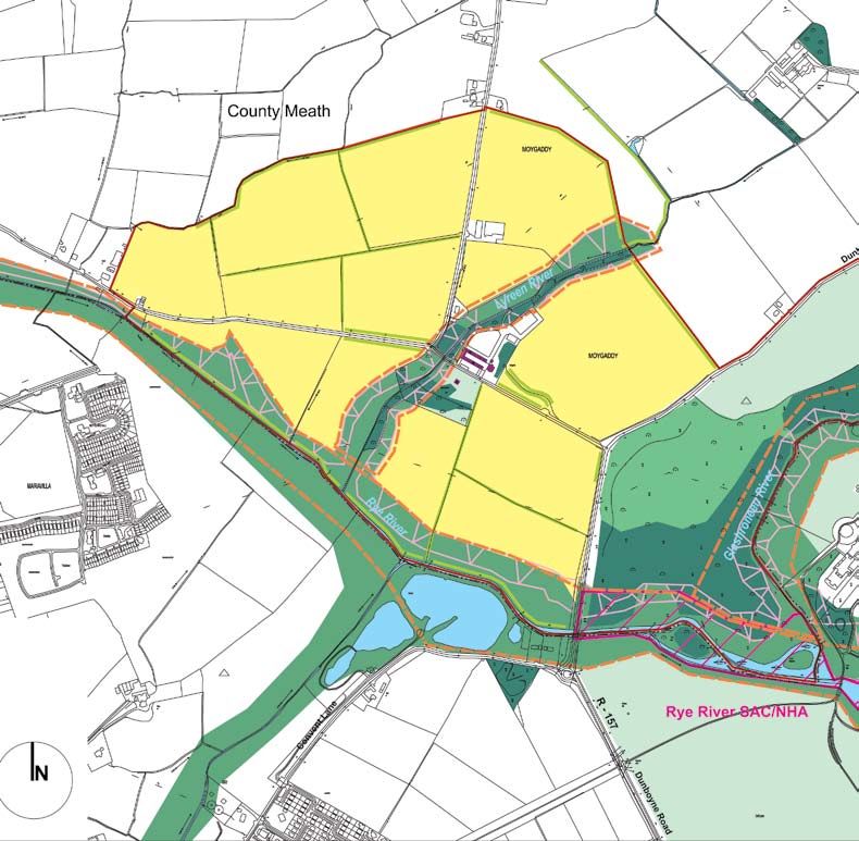
Maynooth Environs Local Area Plan 2009-2015
1.0 Introduction

1.1   Need for Plan                    2
1.2   Strategic Role of Maynooth       2
1.3   Consultation                     2
1.4   SEA/AA Screening									        3

                                   1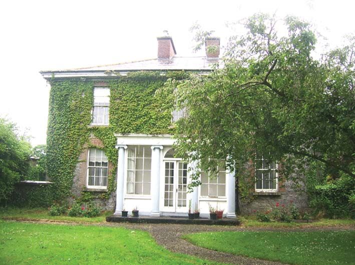
Maynooth Environs Local Area Plan 2009- 2015

1.0       Introduction                                                        The Local Area Plan is required to provide a framework for
                                                                              development of appropriate and complimentary uses that support
1.1     Need for Plan                                                         and complement the role of the University town of Maynooth. This
                                                                              includes Science, Technology and Research activity. This LAP
This Local Area Plan (LAP) relates to lands on the northern environs          will therefore have a vital role in defining future development of
of Maynooth town, within the administrative area of Meath County              Maynooth in the coming years.
Council. The study area comprises some 139 Ha of land located
approximately 1.5km to the north east of the town centre (see figure          This Local Area Plan process, is advanced under Section 20 of
1).                                                                           the Planning and Development Act, 2000, as the appropriate
                                                                              mechanism to establish a suitable planning framework for the area.
It is an objective of the Meath County Development Plan 2007-2013
to prepare a Local Area Plan for the area to the north of Maynooth,           This Plan consists of this written statement and the attached maps,
within 2 years of the adoption of the County Development Plan.                and shall be known as the Maynooth Environs Local Area Plan
The Meath County Development Plan 2007-2013 has identified                    2009-2015. Once adopted, the Plan shall remain in effect for a
five ‘dynamic clusters’ into which economic development will                  period of six years from the date of adoption or until it is the subject
be channelled. The Maynooth Environs LAP lands are situated                   of an amendment, a review or a revocation by the Council. It will
within the ‘M4 Dynamic Cluster’, as identified by Meath County                be subservient to the Meath County Development Plan, 2007-
Council. The subject lands are identified as a location for significant       2013, which is the primary planning document in the County. The
employment/development as part of this dynamic cluster.                       current Meath County Development Plan takes precedence over
                                                                              the Maynooth Environs Local Area Plan in the event of any conflict
1.2    Strategic Role of Maynooth                                             arising between the contents of the two documents.

Maynooth is a designated growth centre in the Regional Planning               Within this document, references to ‘the Plan’ or ‘this Plan’ shall
Guidelines and forms part of a ‘primary dynamic cluster’ with                 denote this Local Area Plan, save where the context requires
Kilcock, Celbridge and Leixlip. It is a major University Town with            otherwise.
a growing student and residential population with established
rail and motorway links to Dublin and the West. The area is well              ‘The Council’ or ‘the Planning Authority’ shall signify Meath County
placed to take advantage of its proximity to the National roads               Council.
network, Dublin Airport as well as national rail network. Maynooth
has been clearly identified in the RPGs as the anchor settlement              All mapping and diagrams throughout the document are orientated
within the overall ‘Primary Dynamic Cluster’. This is primarily due to        in the direction of true north, none are to scale but do contain a
Maynooth’s educational institutions as well as its long-established           scale bar for guidance purposes only. Where there is any apparent
and prominent settlement history.                                             conflict between the text and accompanying illustrations, the text
                                                                              shall be the interpretive determinant.
Meath County Council, are keen to facilitate the realisation of the
Primary Dynamic Cluster (PDC) of Maynooth, Leixlip, Celbridge
and Kilcock contained in the Regional Planning Guidelines for                 Following this introduction, Section 2 of the LAP seeks to establish
the Greater Dublin Area. This will be achieved through continued              the context for the LAP in terms of strategic and statutory planning
partnership with Kildare County Council in the preparation of                 guidance and policies for the defined subject area. Section 3
complimentary and integrated spatial planning frameworks and                  focuses on analysis of the LAP area, to consider what role it
the delivery of necessary physical infrastructure for the environs of         plays in addressing demographic needs, as well as the physical,
Maynooth.                                                                     environmental and economic opportunities and constraints that
                                                                              any future development must consider. Section 4 sets out the aim,
The development of the Maynooth Environs is envisaged by Meath                strategic objectives, and core policies of this LAP. The development
County Council as a natural extension to the town of Maynooth as              strategy is based on the principles of sustainable development is
a location for significant employment generation in the context of            supported in a series of objectives for the area, with associated
its location within the Metropolitan area of the Greater Dublin Area,         maps.
and also represents a reasonable expansion of Maynooth into its
environs. It is anticipated that the LAP would lead to the creation of
a dynamic cluster between the high tech / bio tech industries, and            1.3 Consultation
also with NUI Maynooth; developing a high degree of interaction
between these new technology types and NUI Maynooth.                          As part of the pre-draft phase of this LAP, representations were
                                                                              sought from the general public, and consultations were undertaken,
The primary goal of the plan is to create a unique employment hub             to establish general themes and concepts applicable to the subject
within a legible framework consisting of a series of signature and            area, as a fundamental element of the assembly of baseline
innovative architectural designs which will respect and compliment            information. A public meeting was held on the 6th of October 2008
the historical and ecological qualities of Carton Demesne and                 in Dunboyne. Attendees included Councillors, Landowners, and
Moygaddy Castle and House. This employment hub will have                      Consultants. Comments received emphasised the importance
strong linkages to the NUI Maynooth leading to the creation of an             of the lands as an economic centre of excellence for the County.
area of excellence, and as a premier location for the high tech /             Most attendees were supportive, of preparing a robust planning
bio tech industries. The proximity of Carton House which consists             document that would reconcile and control new economic
of a high quality integrated tourist complex where conferencing,              investment in the area.
banqueting, recreational activities are available, offers the potential
for further synergies.                                                        Two written submissions were received, which are set out in
                                                                              Appendix C. The first submission noted concern with regard to the
                                                                              potential traffic impact of new roads and development in the area;

                                                                          2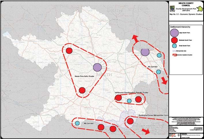
1.0 introduction
Timeframe Progress of statutory LAP process
District (ED) of Rodanstown within the administrative area of Meath
* Week 1 Draft Local Area Plan on display - submissions invited 6 weeks County Council, with a population of approximately 1,068 persons.
Week 6 Preparation of Manager’s Report on submissions received 6 weeks The population within the LAP area lands of 139 hectares is
Week 12 Manager’s Report given to Members for consideration 6 weeks
negligible and is associated with the operation of Moygaddy stud.
Week 18 Plan made unless Members decide to amend 3 weeks
Table 6 of the Meath County Development Plan 2007-2013 identifies
Week 21 Notice of alterations published & submissions invited 4 weeks
500 residential units for the Maynooth Environs LAP area, which
Week 25 Preparation of Manager’s Report on submissions (alterations only) 4 weeks could result in approximately 1,500 persons calculated using an
Week 29 Manager’s Report given to Members for consideration 6 weeks
average of 3.0 persons per household (based on 2006 Census
average for County Meath). Therefore the population capacity of
Week 35 Plan made as per Manager’s recommendation (or) Members make Plan contrary
to the Manager’s recommendations the land bank within the LAP area is estimated to be a maximum of
1,500 persons, within the life of the LAP (subject to availability of
* Week 1 will be the beginning of the statutory process (used in the preparation of an LAP), outlined in Section
infrastructure), and therefore an SEA is not mandatory.
19 of the Planning & Development Act 2000. This process will begin when notice has been given about the
Draft LAP being issued.
Where the population involved is less than 10,000 persons,
Article 14A of the Regulations outlines a ‘screening’ procedure
the need to protect the built heritage of the locality; and to preserve for determining if an environmental assessment of the LAP is
a distinctive transition between urban and rural areas. necessary. In accordance with this a ‘screening’ process has
The second submission expressed support for the adoption of been undertaken to assess the need for an SEA for the LAP, in
a Local Area Plan for the Maynooth Environs ensuring the co- accordance with Environmental Protection Agency (EPA) guidelines
ordinated and integrated approach to the development of the area. in “Development of Strategic Environmental Assessment (SEA)
The submission further noted that the LAP should promote and Methodologies for Plans and Programmes in Ireland (2001-DS-EEP-
provide for a mix of uses including residential, which would support 2/5) Synthesis Report“
the ‘live-work-play dynamic at Carton Demesne;’ and that the LAP
should support the provisions of the Masterplan (SMART Park), in This LAP, is consistent with the strategic Policies and Objectives
setting out the development objectives for Carton Demesne and the of the County Development Plan and associated Strategic
LAP area. Environmental Assessment. Therefore, this screening procedure
concluded that an SEA was not required for this plan. Meath
The Draft Local Area Plan for the Northern Environs of Maynooth County Council undertook statutory consultations with the EPA,
was placed on display from the 19th of January 2009 to the 2nd of Minister for Environment, Heritage and Local Government and
March 2009. The aim of the consultation process was to enable the Minister for Communications, Energy and Natural Resources. The
public and interested parties to give their observations on the Draft Department of Communications, Energy and Natural Resources
Local Area Plan. A total of 13 written submissions were received. A (DCENR) made a formal response. They confirmed an SEA was not
list of the names of people or organisations who made a submission required. However, it was noted that policies contained in the plan
are set out in Appendix C. must ensure the protection of water quality and fishery status of
receiving waters as set out in the Water Framework Directive, and
that development proposed on foot of the LAP would be considered
A wide range of issues were raised, which were given due premature in the absence of delivery of suitable Sanitary Services
consideration in the preparation of this LAP. The Manager’s report infrastructure.
on the submissions made is available on the Meath.ie website.
Appropriate Assessment Screening
Appropriate Assessment (AA) has become an important
consideration for planning authorities. Any draft land use plan
1.4 Strategic Environmental Assessment/Appropriate
(development plans, local area plans, regional planning guidelines,
Assessment Screening
schemes for strategic development zones) or amendment/variation
to it proposed under the Planning and Development Act 2000 (as
Strategic Environmental Assessment Screening
amended) must be screened for any potential impact on areas
Strategic Environmental Assessment (SEA) is a mandatory
designated as Natura 2000 sites (i.e. Special Areas of Conservation
consideration for planning authorities under the Planning and
(SACs) or Special Protection Areas (SPAs)).
Development (Strategic Environmental Assessment) Regulations
2004.
This screening should be based on any ecological information
available to the authority and an adequate description of the plan
Under this legislation, an SEA may be required where a Plan
and its likely environmental impacts. This should take into account
or Programme is subject to preparation and / or adoption by a
any policies that will set the terms for future development. In this
national, regional or local authority, or, prepared by an authority
context, ecological reports prepared in respect of development
for adoption through a legislative procedure by Parliament or
proposals for the area have been reviewed. The Carton SAC (SAC
Government.
site code 001398) comprises some 6.1 hectares of the overall LAP
area of 139 hectares. This area (of 6.1 hectares) is also a proposed
Assessment
Natural Heritage Area, (pNHA). An Appropriate Assessment
Under the Planning and Development (Strategic Environmental
Screening exercise was undertaken on the Draft LAP and the
Assessment) Regulations 2004 (S.I. 436/2004) on the assessment
amendments which deemed that a full Appropriate Assessment
of the effects of certain plans and programmes on the environment,
was not required, having regard to the policies set out within the
a SEA is mandatory for LAP areas with a population of 10,000
LAP, which will provide for the protection of high amenity areas,
persons or more.
especially the protection of the Carton SAC.
According to the 2006 Census, the population of Maynooth Town is
10,715 persons. The area of the LAP is located within the Electoral
3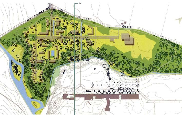
Maynooth Environs Local Area Plan 2009-2015

                                              4
2.0 Context
2.1 Site Location and Description 6
2.2 Strategic Planning Context 7
2.3 Statutory Development Context 8
2.4 SMART Park at Moygaddy Woods, Carton Estate Masterplan 10
2.5 Kildare Development Plan 2005- 2011 10
2.6 Maynooth Development Plan 2002 10
2.7 Carton Avenue Action Area Plan 12
2.8 Planned Development 12
5Maynooth Environs Local Area Plan 2009- 2015
2.1 Site Location and Description
The proposed study area relates to lands located within the administrative area of Meath County Council
located on the northern environs of Maynooth town.
The study area comprises approximately 139 ha of land and is bounded generally by: agricultural lands and
a small number of residences to the north, agricultural land within the Maynooth Development Plan 2002 to
the south, Carton House Demesne (a protected structure) to the east, and Pound Hill and agricultural land
to the west. The Maynooth Environs lands are located approximately 1.5km to the north east of the centre
of the town of Maynooth (see figure 1).
The study area is located within the Electoral District (ED) of Rodanstown within the administrative area of
Meath County Council. The administrative area of Kildare County Council is located immediately adjacent
to the LAP environs lands to the south east and south west boundary of Rodanstown ED.
The study area is bisected by the R157 road which links Maynooth to Dunboyne, located approximately
8 km to the north east. The area to the north west of the RI57 comprises approximately 98 hectares of
land located within a portion of the overall townland of Moygaddy. The land to the south east of the R157
comprises approximately 41 hectares and is located within the north western extent of Carton House
Demesne, a protected structure.
The topography of the LAP environs lands to the west of the R157 is undulating with lands sloping towards
the River Rye Water, which forms the southern boundary of the LAP area. A tributary of the River Rye Water
flows through the centre of this portion of the LAP lands in a north-east/south-west direction adjacent to
Moygaddy house and Moygaddy castle. More detailed analysis of the LAP lands is provided in section 3.
Figure 1 Context of LAP area
62.0 Context
2.2 Strategic Planning Context National Spatial Strategy, 2002 – 2020
The ‘National Spatial Strategy’ (NSS) is a twenty year planning
National Development Plan, 2007 – 2013 framework designed to achieve a better balance of social,
The National Development Plan, 2007 – 2013 (NDP) was published economic, physical development and population growth between
in January 2007 and notes that the Irish economy and society regions. The NSS sets out a national context for spatial planning
will undergo a transformation almost as radical as the changes which will inform regional planning guidelines and strategies, as well
experienced in the past decade of growth and development. This as county and city development plans and strategies.
would be driven largely by the continuing increase in the population
which is projected to reach over five million people by 2021. Under the NSS, Maynooth is categorised as a town with a
population of over 5,000 people. In the context of the NSS, towns
The NDP states that the development of a knowledge-based of this size will act as ‘local capitals’ and provide a range of services
economy is one of the key challenges and opportunities facing and opportunities for employment. It is stated in the NSS that there
Ireland and that the factors which have contributed to Ireland’s is a large number of towns of this size in the Greater Dublin Area
economic success to date will not be sufficient to sustain (GDA) which are primarily located on the main transport corridors
recent achievements. The NDP acknowledges that the Science, radiating from Dublin. One of the issues which the NSS identifies
Technology and Innovation (SSTI) Programme will constitute one for these towns is how they can energise their own catchments
of the principal pillars of the NDP, and will strive towards a vision and their relationships with areas in the neighbouring regions of the
of an Ireland in 2013 internationally renowned for the excellence Border, Midlands, and South East.
of its research and at the forefront in generating and using new
knowledge for economic and social progress, within an innovation According to the NSS the performance of the GDA will remain
driven culture. pivotal to the overall economic well being of Ireland into the future.
The NSS promotes balanced regional development and encourages
According to the NDP, the SSTI programme provides for the developing the full potential of each area to contribute to the
continued development of a world-class research system optimal performance of the State as a whole.
underpinned by the essential physical and human infrastructure,
almost doubling the number of PhD graduates over its lifespan.
The physical consolidation of Dublin supported by effective land
The NPD further states while the level of foreign direct investment
use policies for the urban area itself is identified as an essential
(FDI) in Ireland, relative to the size of the economy, is one of the
requirement for a competitive Dublin.
highest in the world, the growth of international competition for FDI
has led to a decline in Ireland’s share of green-field investments.
Figure 2 Map of Dublin & Mid East Regions, NSS, 2002
7Maynooth Environs Local Area Plan 2009- 2015
Regional Planning Guidelines for the Greater Dublin Area Dublin Transportation Office: A Platform for Change
(2004-2016) The Dublin Transportation Office (DTO) strategy provides the
The Regional Planning Guidelines for the Greater Dublin Area transport planning framework for the Greater Dublin Area to the year
2004 - 2016 (RPGs) seek to provide a robust sustainable planning 2016. The RPG for the Greater Dublin Area indicates that Moderate
framework for the GDA in the twelve-year period up to 2016 within Growth Towns should have regard to the recommendations of the
the context of the National Spatial Strategy vision for 2020. The DTO strategy and subsequent reviews.
Strategy for the future development of the Metropolitan Area will
consist of the consolidation of development, with an enhanced The emphasis on public transport services/ infrastructure in
multi-modal transport system. the towns of Celbridge, Kilcock, Leixlip and Maynooth must be
tailored to suit the existing and potential size of the settlements,
their projected growth, and their role within the GDA. The strategy
indicates that the policies to be adopted in towns such as
Celbridge, Kilcock, Leixlip and Maynooth, should be consistent with
achieving self-sufficiency. This includes adequate linkages both of
the various settlements to each other, and linkages from this area to
the Dublin Metropolitan area and other regional centres.
Transport 21
Transport 21 is the capital investment framework through which the
transport system in Ireland is currently being developed and runs
over the period 2006 to 2015. Transport 21 is fully informed by
the key policies set out in the NSS and also takes account of the
Regional Planning Guidelines. Key to the strategy is the concept
of balanced regional development. To achieve this, a framework
of Gateways, Hubs and other urban and rural areas have been
established, to open up new opportunities in the regions and give
people greater choice in where they live and work.
Transport 21 is also informed by a number of regional land use and
transportation strategies for major urban areas and their hinterlands
including the long term strategy ‘A Platform for Change’.
2.3 Statutory Development Context
Meath County Development Plan 2007-2013
The Meath County Development Plan (CDP) was adopted on the 2nd
of March 2007 and is the statutory plan for the Plan area. The Meath
CDP includes the following strategic objectives:-
Figure 3 GDA Settlement Strategy
SS OBJ 1
Maynooth is identified as a ‘moderate growth town’ under the To prepare Local Area Plans for the urban centres contained
RPGs. The settlement strategy adopted in the RPGs proposes in Table 7 within 2 years of the adoption of this County
separate development policy areas within the Greater Dublin Area; Development Plan in accordance with the provisions of
the Metropolitan Area and the Hinterland Area. The subject lands Sections 18 – 20 of the Planning & Development Acts 2000
are located within the Metropolitan area of the GDA. Maynooth - 2006. These Local Area Plans will replace the individual
which forms part of the Kildare North East Primary Dynamic Cluster Written Statements and Detailed Objectives for Towns and
is illustrated in Figure 2.3. Villages contained in the 2001 County Development Plan
The RPGs also identify two inter-urban relationships – ‘primary
dynamic clusters’ and ‘secondary dynamic clusters’. Maynooth SS OBJ 3
is designated as part of a ‘primary dynamic cluster’ along with the To explore the joint preparation of a Local Area Plan, in
towns of Leixlip, Celbridge and Kilcock. The designation of the conjunction with Kildare County Council, for Maynooth, to
clusters identifies the urban dynamism and relationships between include the area north of Maynooth which is located in Co.
the constituent towns. Meath. It shall be an objective to advance the preparation of
the Joint Local Area Plans within 2 years of the adoption of
Under the RPG strategy towns such as Maynooth, Leixlip, the Development Plan.’
Celbridge and Kilcock will be consolidated with an increase in
overall residential development densities, particularly where in close In this regard, Meath County Council, are keen to facilitate the
proximity to public transport corridors. The RPGs also identify a realisation of the Primary Dynamic Cluster (PDC) of Maynooth,
transportation strategy within the region. This strategy sets out the Leixlip, Celbridge and Kilcock contained in the Regional Planning
Strategic National Roads Projects and identifies an Outer Orbital Guidelines for the Greater Dublin Area. This will be achieved
Route linking Drogheda-Navan-Naas. This is indicated as traversing through continued partnership with Kildare County Council in
the Maynooth Primary Dynamic Cluster between Maynooth and the preparation of complimentary and integrated spatial planning
Kilcock. frameworks and the delivery of necessary physical infrastructure
for the environs of Maynooth including inter alia a section of the
Maynooth Outer Relief Road (within Meath Co. Co. administrative
82.0 Context
area), and services infrastructure for the envisaged development in The Local Area Plan process is identified as a ‘mechanism for delivery’
the wider area. to create a self-sufficient critical mass to ensure that adequate lands
are zoned for a multiplicity of uses, and that densities are appropriate
Economic Development to the location and services available or likely to be available, in
The economic strategy of the Meath County Development Plan particular at existing or proposed public transport nodes.
2007-2013, aims to make Meath one of the premier locations for
indigenous and foreign employment generating investment. In Table 15 of the CDP also identifies the preparation of a Masterplan
seeking to act as a positive force for inward investment, Meath for the development of the proposed high technology/ bio-
County Council propose to remove real and perceived identified technology campus linked with NUI Maynooth within Carton
internal County inhibitors to economic development of all economic Demesne. Please see Appendix D for full text of the action.
sectors. Meath County Council has identified five ‘dynamic
clusters’ into which economic development will be channelled. The Settlement Strategy
Maynooth Environs LAP lands are situated within the ‘M4 Dynamic Maynooth Environs is identified in table 4 of the Meath CDP as a
Cluster’ (cluster no. 5). ‘moderate growth town’ within the metropolitan area of the GDA.
The stated aim of the settlement strategy is to locate population
Section 3.1.7 of the Meath CDP notes the level of economic and growth and channel development in line with the principles of the
employment development has not kept pace with that of residential NSS and RPGs.
development with high levels of commuting to the Metropolitan
Area. The Meath CDP notes the development of the environs of Maynooth
must be on a balanced and sustainable basis whereby residential
In formulating its policies to promote employment and industry, development is matched by the delivery of key physical and social
the CDP aims to exploit Meath’s strategic location and competitive infrastructure and a strong economic base. Table 6 of the Meath
advantages for industrial and commercial activities whilst seeking CDP 2007-2013 identifies 500 residential units for Maynooth
to safeguard the environment from potential adverse environmental Environs due its designation as a Moderate Growth Town in the
impacts. Settlement Strategy within the Metropolitan area.
The CDP identifies in Table 15 (shown in Appendix 3) ‘actions’ and The Development Plan notes only strategic additional residential
‘mechanisms for delivery’ to achieve the following objective:- land use zoning shall be agreed over the Development Plan period
2007-2013. The location of these strategic additional residential
‘To plan and provide a Strategy which would enable south-west lands shall reflect the Settlement Strategy contained in this
Meath maximise the potential and opportunities associated with its Development Plan and the Regional Planning Guidelines for the
strategic location within the M4 Corridor.’ Greater Dublin Area. In this regard Maynooth Environs is identified
as ‘strategic’ in the context of its designation as a Metropolitan Area
Moderate Growth Town.
Figure 4 Five Dynamic Clusters within Meath
9Maynooth Environs Local Area Plan 2009- 2015
2.4 Smart Park at Moygaddy Woods, Carton Estate, 2.5 Kildare Development Plan 2005-2011
Masterplan (December 2008)
Economic Strategy
A non-statutory Masterplan for the SMART Park at Moygaddy In order to support Dublin’s national role in the global economy, four
Woods located in the Carton Demesne Lands was completed by centres of economic critical mass, called ‘primary dynamic clusters’
Murray O’ Laoire Architects in December 2008 on behalf of Alanis have been identified at the nodes where the four main radial routes
Ltd and Carton Estate. This masterplan has been prepared in out of Dublin City intersect the proposed Dublin Outer Orbital Route
accordance with Table 15 of the County Development Plan, and the (which will run outside the M50 from Drogheda to Wicklow). Two
objective to provide for hi-tech/bio-tech industries in that location, of these four centres are located in Kildare, the first of which is the
As such, this Masterplan plan is an important planning document Kilcock, Leixlip, Maynooth and Celbridge cluster in the north of the
for this part of the LAP lands, and provides a suitable framework county.
for development to proceed in this area. This LAP provides a
complimentary statutory policy framework to the Masterplan. Policy ED1 of the 2005 County Development Plan states the following
in relation to the dynamic clusters:
The vision of the Masterplan is to provide a high-quality campus
to the north-west of Carton Demesne with a strong emphasis on ‘To support and implement the strategic development of
business, innovation and technology based research, where NUI identified dynamic clusters and towns in accordance with the
Maynooth is an important development partner. The Masterplan Integrated Framework Plans for Land Use and Transportation
seeks ‘to create a village atmosphere which will include for a (IFPLUT) as required under the NSS and supported in the
mixture of employment, enterprise, education and some residential draft Regional Planning Guidelines’.
accommodation and supporting services to include a crèche, café,
shop and common room.’ Thus, the 2005 County Development Plan designates Maynooth as
forming part of a ‘primary dynamic cluster’ in line with the provisions
Section 2 of the Masterplan envisages that building plots of the RPGs. It is clear that suitable provisions should be included
should be organised along a main planted spine or boulevard, in the Maynooth LAP 2009 to enable the town fulfil its role, together
to mirror the linear alignment of Carton House. It is a long-term with the towns of Kilcock, Leixlip and Celbridge, to develop as a
strategy to create a homogenous intact woodland in Moygaddy; centre of economic critical mass.
achieved through a combination of measures including woodland
management, the establishment of new woodland and the retention 2.6 Maynooth Development Plan 2002
of existing trees. The Masterplan sets out an organisational
concept consisting of the following elements:- Development Vision
The development strategy of Kildare County Council in relation
• Main spine/boulevard; to Maynooth is ‘to consolidate Maynooth as a University town of
• Buildings fronting onto the main spine; international importance. In order for this to be achieved the Council
• The retention and restoration of the Moygaddy Avenue and Queen recognises that the town must offer living and working conditions,
Victoria Walk; educational, recreational and cultural opportunities of the highest
• The establishment of green fingers which subdivide the developable standard in an attractive urban environment. The Council aims
area and form pedestrian connections to Carton House; to achieve this in partnership with the people of Maynooth, the
• The restoration of the woodland along the Glashroneen river valley; university authorities and other agencies and organisations with an
• The re-establishment of perimeter planting to the Dunboyne road;
interest in the town’s development’.
• The establishment of a new Moygaddy woodland.
The Council aims to allow the opportunity for the town to develop as
The Masterplan sets out envisaged building lines and land uses
a centre of learning and high technology enterprise. Section 2.5.2
within the SMART Park lands. Essentially the intention is to provide
of the Maynooth Development Plan 2002 states that the ‘Council
office/research buildings to the north of the access road (off
will co-ordinate its roads programme with Meath County Council to
Moygaddy gate), and residential units (approx. 100) in the form of
provide an efficient road network for the town of Maynooth.’ Map 1
‘collegiate’ style housing and woodland housing units to the south
of the Maynooth Development Plan 2002 identifies a roads objective
of the access road. A service centre comprising of a crèche, café,
traversing the lands within the administrative area of Meath
shop, and commons room was identified centrally within the lands
County Council, which now form the study area as identified in the
at the junction of the main spine road and access road. The main
Maynooth Environs LAP.
boulevard (spine road) as comprising a road, pedestrian and cycle
lanes, along with tree planting.
The Council aims to allow the opportunity for the town to develop
as a centre of learning and high technology enterprise. The plan
The design process was informed by an analysis of both the envisages that this will be achieved through:
historical development of the Demesne landscape and an appraisal
of the landscape character. The Masterplan notes that the • Seeking to develop Maynooth as a compact town, where all
framework is built around the Moygaddy avenue and Queen Victoria residents are within easy walking distance of the town centre,
avenue, which are to be re-established as green linkages or planted • Facilitating the expansion and further development of the
avenues linking the ‘SMART Park Campus’ to Carton House. The universities,
illustrations below comprise the Indicative Masterplan; Scenarios A • Ensuring an adequate supply of serviced, zoned land is made
and B, as included in the document. available to accommodate future population and economic
expansion,
• Strictly controlling ribbon development and urban sprawl,
• Ensuring all new development in the town, by the Council or by the
private sector, is of the highest standard.
102.0 Context
Indicative Masterplan - Scenario A Smart Park at Moygaddy Woods, Carton Demesne
Indicative Masterplan - Scenario B Smart Park at Moygaddy Woods, Carton Demesne
112.0 Context
The Maynooth Development Plan is currently under review and
indications are that a Draft will be on display in mid 2009. Meath
County Council will continue to liaise with Kildare County Council in
this process.
2.7 Carton Avenue Action Area Plan (CAAAP) July 2006
The stated objective of the Carton Avenue AAP is ‘to provide a
managed parkland for Maynooth, whilst facilitating the development
of high quality residential schemes that compliment the urban
character and design of the Town.’ The CAAAP notes that the
development of the AAP lands will necessitate undertaking
improvement works of the local road network in order to cater for
increased levels of demand.
2.8 Planned Development
The LAP area is not static in planning and development terms.
There has been some recent activity in the form of planning
applications and decisions. Recent development trends in the
designated LAP area were analysed in order to establish general
development trends taking place in the subject area.
There are two notable planning applications within the overall study
area. The proposed development on the Moygaddy stud lands
comprises a ‘Global Studio’ to consist of a building of 4,667 sq
m with associated offices, conference/meeting rooms, canteen,
storage and classroom. This development will be located at the
junction of the R157 and the CR571, and therefore is situated at an
important location in the overall Plan area.
Meath County Council granted permission with conditions under
material contravention procedure with respect of this development
on the 6th of October 2008. A final grant of permission was issued
by Meath County Council on the 19th of February 2009.
The planning application on the Carton Demesne ‘Smart Park’
lands comprises inter alia a mixed use development consisting
of 2. blocks of office development (5,156 sq m), 1 innovation
centre (2,615 sq m), 1 sports science building (c. 3,309 sq m), 1
research centre (3,278 sq m), 100 residential units, 1 neighbourhood
centre of c. 1,280 sq m, 735 car parking spaces, realignment of a
portion of the R157 (with associated reconstruction of a portion of
Carton Demesne Wall (a protected structure), and the relocation
of Moygaddy Gate (a protected structure). Meath County Council
issued a Notification of a Decision to Grant Permission on the 9th of
March 2009. The decision (at time of writing) is currently subject of
a First Party appeal and Third Party Appeals to An Bord Pleanala.
123.0 Analysis
3.1 Key Demographic and Socio-Economic Trends 14
3.2 Physical Development Trends 15
3.3 Landowners 15
3.4 Historical, Archaeological and Natural Heritage 15
3.5 Site Analysis 18
3.6 Movement and Access 19
3.7 Services and Utilities 20
13Maynooth Environs Local Area Plan 2009- 2015
3.0 Analysis Age Profile
The percentage of the population in the working age cohorts (15-64)
increased for all of the areas studied between 1996 and 2006. For
3.1 Key Demographic and Socio-Economic Trends Meath, the percentage of the working population increased from
64.9% in 1996 to 68.6% in 2006, which is the same as the State.
The study area is located within the Electoral Division (ED) of The working age cohort of Maynooth ED is significantly higher at
Rodanstown and borders Kildare and the Maynooth ED to the 76.7%, reflecting the strong influence of the university in the town.
south. While the subject site is located within County Meath, it is The percentage of the population in the working age cohort for the
considered appropriate to also include Maynooth and Kildare data ED of Rodanstown was 70.6% in 2006, a slight decline from the
in the analysis. 2002 figure of 73.8%.
The most recent census of population taken by the Central Census data from 1996, 2002 and 2006 indicate that the percentage
Statistics Office CSO was taken in April 2006. Demographic trends of population within the dependent age cohort (0-14 and 65+) in
for the study area have been analysed at region, county, town and all areas studied is in decline. The decrease in the percentage of
local levels. the population within the dependent age cohort for Meath, Kildare,
Maynooth Electoral Division and Rodanstown Electoral Division is
Population in line with changes at State level. In all areas the decrease in the
Table 1 below illustrates the change in population over a twenty percentage within the dependent age cohort was most pronounced
year period using census data from the 1986 census to the most between the 1996 and 2002 census periods. This figure for the
recent census in 2006. The populations of Meath and Kildare have State decreased from 35.1% in 1996 to 32.3% in 2002, which
increased consistently over the 20 year period. County Meath was similar to changes at county level. The Electoral Divisions
recorded an increase of 56.5% between 1986 and 2006, while of Maynooth and Rodanstown, however, recorded a lower than
County Kildare experienced a 60.3% increase over the same period. average proportion of the population in the dependent age cohort.
The population of County Meath recorded in 2006 of 162,621
persons represented a 21.4% increase on the figure for 2002. The Table 2 Age Profile 1996-2006
population of County Kildare increased by 12.0% between 2002
Age Cohort 0-14 15-24 25-44 45-64 65+
and 2006.
State 1996 23.7% 17.5% 28.0% 19.4% 11.4%
State 2002 21.1% 16.4% 30.1% 21.2% 11.1%
Table 1 Population Change 1996-2006
State 2006 20.4% 14.9% 31.7% 21.9% 11.0%
Area No of Persons Meath 1996 26.1% 16.8% 28.2% 19.3% 9.7%
1986 1991 1996 2002 2006 Meath 2002 23.6% 15.4% 31.7% 20.5% 8.7%
State 3,540,643 3,525,719 3,626,087 3,917,203 4,239,848 Meath 2006 23.4% 13.5% 34.7% 20.4% 8.0%
Co. Meath 103,881 105,370 109,732 134,005 162,621 Kildare 1996 26.5% 18.1% 30.6% 17.6% 7.2%
Co. Kildare 116,247 122,656 134,992 163,944 186,335 Kildare 2002 23.7% 16.5% 33.4% 19.7% 6.7%
Maynooth Town 4,768 6,027 8,528 10,151 10,715 Kildare 2006 23.1% 15.0% 34.6% 20.5% 6.9%
Maynooth ED ‘96 20.7% 27.9% 34.3% 12.4% 4.7%
Rodanstown ED 1,135 1,187 1,116 1,112 1,068
Maynooth ED ‘02 20.4% 25.5% 34.8% 15.0% 4.3%
Maynooth ED 5,525 6,807 9,286 10,837 11,500
Maynooth ED ‘06 18.1% 25.5% 34.1% 17.2% 5.2%
Source: Census of Population 1986, 1991, 1996, 2002, 2006. Rodanstown ED ‘96 22.9% 20.6% 24.1% 23.4% 9.0%
Rodanstown ED ‘02 17.4% 19.4% 25.4% 29.0% 8.8%
Rodanstown ED ‘06 18.9% 13.9% 27.2% 29.5% 10.5%
Household size
Household size within the State has fallen steadily over the past
decade. According to the Strategic Planning Guidelines (SPG),
average household size in the Greater Dublin Area (GDA) is
expected to fall to an overall average of 2.5 by the year 2011. This
trend, which is subject to changing cultural and social conditions
(i.e. the formation of smaller average family sizes and increasing
rates of household formation), will have huge implications on future
housing unit design requirements.
The average number of persons per household in the State in
2006 was 2.8 persons, falling from 3.2 persons in 1996, while that
Figure 5 Percentage change in population 1986-2006 recorded for Kildare county was 3.5 in 1996 falling to 3.0 in 2006.
Future Trends Table 3 Household Size 1996-2006
The subject area is within the catchment area of Maynooth town. Area 1996 2002 2006
The towns of Maynooth, Leixlip, Kilcock and Celbridge, together State 3.2 2.9 2.8
forming a ‘Primary Dynamic Cluster’, have been designated as Meath 3.5 3.2 3.0
‘Moderate Growth Towns’ in the Regional Planning Guidelines Kildare 3.5 3.2 3.0
for the Greater Dublin Area (2004-2016). Under these guidelines,
Maynooth ED 3.3 3.2 3.1
each town has a projected population of between 5,000 and
Rodanstown ED 3.6 3.3 3.1
15,000 persons. It is anticipated the population within the ‘Primary
Dynamic Cluster’ will increase into the future. Source: Census of Population 1996, 2002, 2006.
143.0 Analysis
Employment The Rye Water Valley/Carton Special Area of Conservation (SAC site
The number of people at work in the State increased by 47.6% code 001398) is located between Leixlip and Maynooth extending
between 1996 and 2006. The corresponding increase at county along the River Rye Water, a tributary of the River Liffey. A portion
level proved more striking, where the figure for Meath increased of this SAC site is located in the south eastern portion of the overall
by 93.8%, and in Kildare it increased by 78.5% over the same LAP lands within Carton Demesne situated to the east of the RI57 at
ten-year period. Employment levels in the ED’s of Maynooth and Kildare Bridge extending approximately 600m to the eastern side of
Rodanstown increased quite significantly, by 45.5% and 27.9% Carton Bridge. This area is also a proposed Natural Heritage Area,
respectively. (pNHA). The SAC comprise some 6.1 hectares of the overall LAP
study area of 139 hectares. Map 2 in Appendix E shows the natural
environment constraints.
The Rye Water Valley/Carton SAC is of importance due to the
presence of several rare and threatened plant and animal species
and due to the occurrence of a mineral petrifying spring considered
to be rare in Europe and is a habitat listed on Annex I of the Habitats
Directive. This rare spring is located at Louisa Bridge approximately
4.5km to the south east of the LAP boundary near Leixlip. The
River Rye Water is a spawning ground for Trout and Salmon, and
the rare White-Clawed Crayfish, which is listed in Annex II of the EU
Habitats Directive.
Figure 6 Percentage change in employment levels 1996-2006
The Moygaddy woodland and rivers comprising River Rye Water,
River Glashroneen, and the tributary river adjacent to Moygaddy
house provide habitat for a relatively rich fauna including red deer
(introduced), badger, otter, bats, raven, and long-eared owl.
3.2 Physical Development Trends
The LAP area lands includes two distinct elements, comprising
Moygaddy stud on lands to the west of the R157, and the Carton
Demesne lands located to the east of the R157. The lands to the
west of the R157, of some 98 hectares, are currently in use as a
stud. The existing buildings on these lands reflect this use and
consist of a purpose built stud dating from the 1830’s. The LAP
area lands to the east of the R157 currently of approximately 41
hectares, consists of a mixture of pasture, scrub, and woodland
associated with Carton Demesne. It is apparent from Historical
mapping that this woodland has evolved over the past couple of
hundred years.
3.3 Landowners
The LAP area lands include of 2 main landholdings comprising 1 Figure 7 Portion of Carton SAC looking east at Kildare bridge
Moygaddy stud on lands to the west of the RI57, and the Carton
Demesne lands to the east of the R157.
3.4 Historical, Archaeological and Natural Heritage
The natural environment refers to soils, water (biodiversity), any
designated sites of national and international importance, protected
species (flora and fauna), geological heritage, forestry and water
resources. The built environment refers to all man-made features
in the environment including archaeological sites, buildings and
structures such as bridges.
Natural Heritage
The topography of the LAP environs lands to the west of the R157
is undulating with lands sloping towards the River Rye Water, which
forms the southern boundary of the LAP area. A tributary of the
River Rye Water flows through the centre of this portion of the LAP
lands in a north-east/south-west direction adjacent to Moygaddy Figure 8 Moygaddy Wood, within Carton Demesne Wall
house and Moygaddy castle.
15Maynooth Environs Local Area Plan 2009- 2015
Built Heritage
The eastern portion of the LAP area is located within the curtilage
of Carton Demesne. Carton Demesne is recognised as one of the
great enclosed estates in Ireland and was the seat of the Earls of
Kildare (later Dukes of Leinster) until the early 20th Century. The
portion of Carton Demesne located within the Maynooth Environs
LAP boundary consists of woodland associated with Carton
Demesne, known as Moygaddy Woods, within the walled estate,
which encloses an 18th Century landscaped parkland.
Historical OS mapping shows the evolution of this woodland area
as a planned extension of the Demesne to the west to include a
network of radial walkways, the most notable being the ‘Queen
Victoria Walk’, which traverses the woodland to Victoria Gate,
located on the Carton Demesne Wall to the north west.
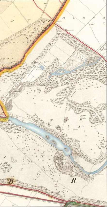
A portion of the Carton Demesne wall is located within the LAP
Environs lands (along the R157 Dunboyne to Maynooth road) and
is a Protected Structure, and is included in Meath County Council’s
Record of Protected Structures (under Reg. No. MH053-100).
Appendix E, Maps 4 and 5 shows historic mapping of the area from
1837 and 1909.
Moygaddy Castle, (RMP No. Me053-1756) is the only known
archaeological monument on the overall LAP lands.The remains
comprise a small castle or keep. Moygaddy House is a two storey
over basement Georgian house. The complex appears to have
been purpose built for breeding racehorses in the mid to late 19th
Century, where the extensive stables and paddock formed part of
the original development. It is not listed in the National Inventory
of Architectural Heritage and is not a protected structure. Together
with the bridge, which was built at the same time as Moygaddy
House, traverses the Lyreen stream, these structures form a locally
important element of the historical built Heritage fabric of the area.
Map 3 in Appendix E shows the built heritage constraints in the LAP
area. Figure 10 Moygaddy Castle
Landscape Conservation
The Meath CDP notes that County Meath has a rich natural
heritage, which includes scenic river valleys, rolling farmland, a
network of mature hedgerows, and diverse coastal habitats, all of
which are influenced by land use and management.
According to the Meath Landscape Character Assessment, set
out in the Meath Development Plan 2007-2013, the LAP lands
are located within Landscape Character Area LCA no. 11 -South
East Lowlands, Lowlands which are described are ‘predominantly
rolling lowland with large areas dominated by attractive landscapes
and associated parkland’. LCA No. 11 is considered to have a
very high landscape value; moderate landscape sensitivity; and
regional landscape importance. Although there are no protected
views identified within the Meath Development Plan, the Kildare
Development Plan 2005-2011 identifies protected views from
Figure 9 Section of Carton Demesne Wall the north west of Carton Demesne House towards the eastern
boundary of the LAP lands.
Mature Trees
Mature trees are located in a number of locations throughout the
subject area, primarily within Carton Demesne (Moygaddy Wood)
and also along the field boundaries of the agricultural lands, along
river valleys as well as road boundaries, within Moygaddy stud.
Occasional, free standing trees can be also found within fields.
163.0 Analysis
Figure 11 Moygaddy House
Figure 12 Moygaddy Stud Figure 13 Woodland within Carton Demesne
17Maynooth Environs Local Area Plan 2009- 2015
3.5 Site Analysis • The lands within Carton Estate are physically and visually
separate from Carton House;
Maps 2 and 3 show the principal opportunities and constraints • There is the potential to reuse the exiting buildings associated
of the LAP area lands as well as node points, likely desire routes, with Moygaddy stud into a services centre for the area;
pedestrian and cycle linkages, road reservations, and proposed • There is the potential to create a substantial amenity/recreational
location of neighbourhood centre. (passive and active) area adjacent to Moygaddy castle;
• There is a potential to accommodate an additional crossing over
The following bullet points summarise the foregoing analysis of the the Rye Water River Valley to increase the permeability of the area
LAP lands: and provide additional strong connections between the town core
of Maynooth and LAP area; and
Opportunities
• To increase the permeability of the area and provide additional
• The subject lands provide a substantial land bank for the
connections between the town core of Maynooth and LAP area.
development of a high quality Science and Technology
employment hub for the County of Meath within the M4 Dynamic
cluster; Constraints
• There is a need to upgrade the services in the area;
• The subject lands provide a land bank for the delivery of limited
residential and some commercial development to be delivered • There is a need to upgrade existing roads within the LAP area
in conjunction with the phased development of Science and to allow for a comprehensive development of the subject lands
Technology lands; which supports a localised road network;
• The lands are in close proximity to Maynooth town centre, and NUI • The importance of the Rye Water river valley cSAC and pNHA
Maynooth and there is good potential for direct pedestrian/cycle designations are important considerations in relation to the
path linkage to the town centre, along linear parks; development capacity of the lands;
• The lands under consideration for development are located within
close proximity to the network of national and regional roads;
• The LAP provides the opportunity to improve the existing
infrastructure of the area in order to facilitate future development;
• The Rye Water river and its tributary, the Lyreen river (as well as the
Glashroneen river) represent major amenities for the area. There is
an opportunity to augment the rivers’ corridors by creating a semi-
natural open space along its banks;
• The general environment of the study area provides an attractive
natural setting comprising rolling fields and mature hedgerows
(Moygaddy) and woodlands (within the Carton Demesne lands);
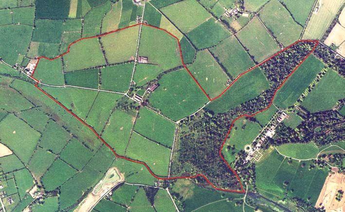
Figure 14 Arial View of Study Area
183.0 Analysis
3.6 Movement and Access There are two further third class roads which traverse the LAP area
lands comprising the CR571 which follows an east west direction
Existing bus services from the R157, and the CR1146, which follows a north south
Maynooth town is served by bus transport with a range of services direction from the CR571, adjoining Moygaddy stud (also known as
to centres including Dublin City Centre, Lucan, Leixlip and the Kilcloon road). There is an objective (INF OBJ 17) in the Meath
Dunboyne. Bus Eireann and Dublin Bus currently operate both local County Development Plan 2007-2013 ‘to liaise with Kildare County
and expressway services through Maynooth. Maynooth is served by Council in the identification, design, reservation and delivery of
four commuter services (nos. 66, 66x, 67a, 67x) that arrive every 10 the section of the Maynooth Outer Relief Road located within the
minutes at peak times, and a ‘nite link’ service (no. 67n). administrative area of Meath County Council
Existing rail Meath County Council are keen to ensure the delivery of this
The rail service at Maynooth railway station located approximately important piece of infrastructure for the town of Maynooth, which
2km from the LAP lands includes the mainline intercity service on will be facilitated by the development of the lands within the LAP
the Sligo - Connolly line. The capacity on the line is undergoing boundary. The upgrading of the R157 is also an important objective
substantial improvements. There are currently 32 daily commuter for Meath County Council.
services between Maynooth and Dublin City Centre, stopping at a
total of 11 stations. The area will also benefit from the Leinster Outer Orbital Route
proposed in the Regional Planning Guidelines for the Greater Dublin
Existing Road Network Area. However, a completion date for this project has yet to be
The LAP area is bisected by the R157 road in north east, south confirmed, or an alignment identified.
west direction, which links Maynooth to Dunboyne, located
approximately 8 km to the north east. The R157 acts as an Existing Pedestrian and Cycling Facilities
important regional distributor road in the Mid East Region, There are no separate pedestrian routes or cycle-ways serving the
connecting the M7, M4 and N3. LAP area. Pedestrians and cyclists currently share road space with
motor vehicles.
Figure 15 Junctions within LAP boundary
19Maynooth Environs Local Area Plan 2009- 2015
3.7 Services and Utilities service the LAP area lands. There is no surface water infrastructure
either on the R157 or the other two local roads, which traverse the
Water LAP area.
There are currently no public water mains located within the LAP
lands. Within the administrative area of Kildare County Council, in Other Utilities
Carton Demesne, there is a 200mm diameter water-main (in private The area has good access to the regional ESB network. There are a
ownership) which connects to a 450mm diameter water-main on the number of ESB lines which traverse the LAP area lands comprising
R148 to the south of the study area. a 220 kv overhead line and a 10 kv line located in the north western
portion of the LAP area lands, as well as a 10 kv overhead line
Sanitary Services located in the south east of the LAP area lands. The development
Currently there is currently no available foul wastewater treatment of the LAP area lands will require the provision of additional
capacity locally to service the LAP area lands. There is no gravity substations and appropriate network infrastructure. Other utility
main either on the R157 or the other two local roads, which traverse services such as telecommunications and gas will require action on
the LAP area. the part of the utility providers.
Surface Water Services In particular, the provision of a high capacity broadband network
Currently there is very limited surface water capacity locally to is a pre-requisite for the delivery of a high quality Science and
Technology based campus.
Figure 16 Maynooth Railway station and Royal Canal
20You can also read