Maunu and Hora Hora Structure Plan - Adopted February 2009 - Whangarei District Council
←
→
Page content transcription
If your browser does not render page correctly, please read the page content below
Maunu and Hora Hora

    Structure Plan

  Adopted February 2009
Maunu and Hora Hora Structure Plan
Table of contents
1 Introduction ................................................................................................................................................. 4
1.1 Purpose of a Structure Plan ................................................................................................................ 4
1.2 Legal Status of Structure Plan ............................................................................................................ 5
1.3 Study Area........................................................................................................................................... 5
Figure 1 Maunu Area - Location ............................................................................................................. 6
1.4 Public Participation .............................................................................................................................. 7
1.5 Tangata Whenua ................................................................................................................................. 7
1.6 Long Term Council Community Outcomes ......................................................................................... 7
1.6.1 A Sustainable, Environmentally-Responsible District which values its Natural Uniqueness ....... 7
1.6.2 A District which is safe and crime-free......................................................................................... 8
1.6.3 A Community which is healthy and educated .............................................................................. 8
1.6.4 A Vibrant and Growing Local Economy ....................................................................................... 8
1.6.5 District with Community Programmes and Facilities for All ......................................................... 8
1.6.6 A Community which values its Culture and Heritage ................................................................... 8
2 Development Strategy ................................................................................................................................ 9
2.1 Development Goals and Objectives .................................................................................................... 9
2.2 Strategic Options ............................................................................................................................... 10
2.3 Spatial Development Strategy........................................................................................................... 11
3 Current Profile .......................................................................................................................................... 12
3.1 Regional and District Context............................................................................................................ 12
3.2 Profile of Study Area ......................................................................................................................... 12
3.2.1 Historical Background ................................................................................................................ 12
3.2.2 Population .................................................................................................................................. 13
Figure 2 Maunu-Horahora Population .................................................................................................. 13
3.2.3 Natural Features ........................................................................................................................ 13
Figure 3 Land capability Classification ................................................................................................. 15
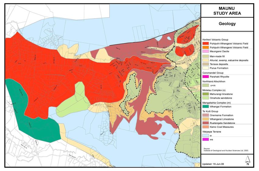
Figure 4 Maunu Area – Geology .......................................................................................................... 17
Figure 5 Kirikiri Catchment ................................................................................................................... 18
Figure 6 Raumanga Catchment ........................................................................................................... 19
Figure 7 Current District Plan Map ....................................................................................................... 23
Figure 8 Protected Area ....................................................................................................................... 24
Figure 9 Maunu Area – Resource Areas .............................................................................................. 26
3.2.4 Engineering Services and Infrastructure.................................................................................... 27
Figure 10 Water Services ....................................................................................................................... 28
Figure 11 Wastewater Services.............................................................................................................. 29
Figure 12 Stormwater Services .............................................................................................................. 30
Figure 13 Electricity and Gas Networks ................................................................................................. 31
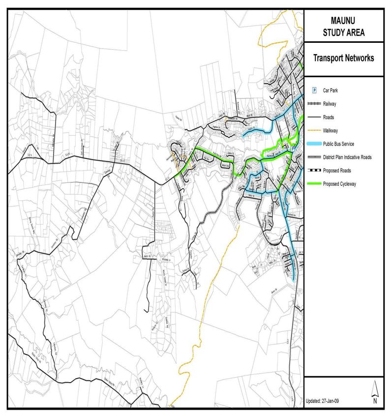
3.2.5 Transportation ............................................................................................................................ 32
Figure 14 Transport network .................................................................................................................. 33
3.2.6 Land Availablity .......................................................................................................................... 34
3.3 Summary of Development Issues ..................................................................................................... 34
4 Maunu Structure Plan Proposals.............................................................................................................. 35
4.1 Proposed Roading network in Maunu ............................................................................................... 35
4.2 Consideration of additional commercial land .................................................................................... 35
4.3 Land Use Proposals .......................................................................................................................... 36
4.3.1 Extension of Living 1 Zoning on Pompallier Estates Road ........................................................ 36
4.3.2 Extension of Living 3 / Future Living 1 Zoning on Austin Road ................................................. 37
4.3.3 Living 1 Zoning at O’Shea Road / Kotuku Street / Raumanga Valley Road.............................. 39
4.3.4 Extension around Te Hape Road Residential Settlement ......................................................... 40
4.3.5 Rural-residential Zoning between Te Hape Settlement and Hawken Road .............................. 41
4.36 Retaining the Countryside Zoning on Cemetery Road .................................................................. 42
4.4 Overall Development Assessment .................................................................................................... 42
Figure 16 Projected Population Growth in the Maunu Area ................................................................... 43
Figure 15 Potential Capacity of the Proposed Land Use in Maunu Area ............................................... 43
Figure 15 Maunu Area – Proposed Land Use ........................................................................................ 44
09/2868 2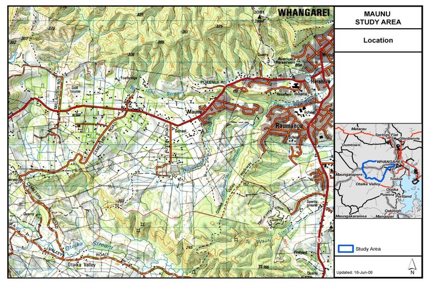
Maunu and Hora Hora Structure Plan

5      Implementation ......................................................................................................................................... 45
    5.1    Issues ................................................................................................................................................ 45
    5.2    Project Identification and Prioritisation .............................................................................................. 45
      Economic Development ........................................................................................................................... 45
      Infrastructure ............................................................................................................................................ 45
Appendix 1              Resource Notations ................................................................................................................ 50
Appendix 2              Important Geological Sites and Landforms within Study Area ............................................... 52
Appendix 3              Designations ........................................................................................................................... 53
Appendix 4              Urban Growth Strategy – Strategic Issues ............................................................................. 55

09/2868                                                                                                                                                            3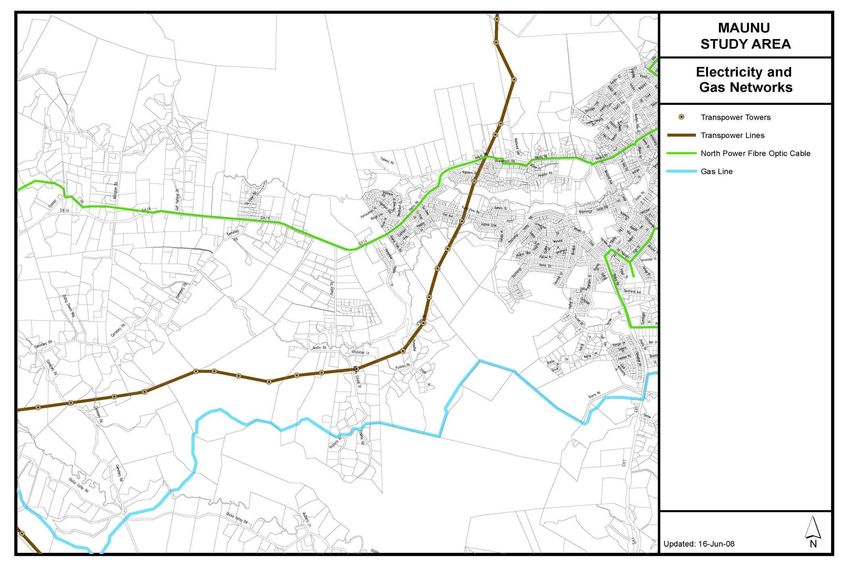
Maunu and Hora Hora Structure Plan
1 Introduction
The Urban Growth Strategy, which was commissioned in 2002, identified a number of urban development
issues around Whangarei City that needed addressing by Council and the Community. The resulting
recommendations were adopted in 2003 as an official Council working document.
The Urban Growth Strategy divided Whangarei City environments into eleven distinct areas for ease of
reference and administration. These areas became known as Structure Plan Study Areas, with each having
its own detailed study for planning purposes.
In each of these study areas, a number of public meetings were held with local residents and interest groups
to discuss specific planning proposals.
The land use proposals discussed in this report reflect the views of the community and Iwi, which were
expressed from consultation meetings held in the Maunu area.
Council commissioned a number of technical studies to determine the physical opportunities and constraints
to development. These include, but are not limited to, geotechnical reports, landscape reports, natural
hazards assessments, transportation, and heritage assessments. In addition, residents’ views and
aspirations were collated and analysed against these report by technical experts from relevant Council
departments for feasibility and funding perspective and the possible prioritising of potential development
activities.
It is important to note that these proposals are long term and their implementation depends on their eventual
incorporation into the statutory planning documents, such as the District Plan and the Long Term Council
Community Plan. It is also important to note that further feasibility studies maybe required at the time of
implementation of some of the proposals as circumstances changes with time.
Land identified for particular use in this Structure Plan is subject to legal processes of negotiated
agreements, acquisition or designation. Council will follow due process in making sure that all necessary
procedures are followed before any land use change takes place, as proposed in this Structure Plan.
Landowners or developers are free to apply for District Plan Changes using the recommendations identified
in this Structure Plan where Council does not have such plans in terms of its policy on public/private plan
changes initiatives.
1.1 Purpose of a Structure Plan
Structure Planning is an important tool in managing the orderly growth of the community to assure that
adequate public services are provided, important natural and cultural assets are protected and the area
remains competitive for jobs and investment. This Structure Plan is an example of ‘integrated management’
that brings together all of Council’s functions in a plan for the Maunu/Hora Hora area.
The general purpose of this Structure Plan is to provide for the sustainable management of the natural and
physical resources of the Maunu and Hora Hora area, in accordance with the aspirations of the local
community and to the benefit of the wider Whangarei District.
The goal of all Structure Plans is to make progress toward sustainable communities with high quality of life,
safety for all residents, efficient use of ratepayers’ dollars and assurance of the long term viability of
residential and business investment.
All Structure Plans are guided by three simple principles of land development to achieve these goals:
Transition provide for a more gradual transition of densities from urban to countryside and limit
impacts on the state highway system and economic viability of agriculture.
Contiguous allow long term consolidation of the urbanised areas by allowing densities to increase on
the fringes in the future as the market demands.
Infill promote infill development in areas that are now, or are planned to be, serviced.
This approach to designating land for new urban development will help protect the essential economic,
environmental, social and cultural values of the District and contribute to long term sustainable growth.
09/2868 4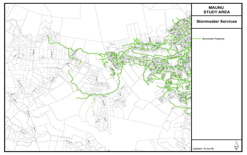
Maunu and Hora Hora Structure Plan
To achieve sustainable and integrated management, the Plan will:
provide an overall land use plan for growth which is compatible with the infrastructure and
environmental capacities of the area to sustain urban and urban fringe development
show how economic, social and cultural matters are being provided for and managed alongside
environmental considerations, and to
provide a co-ordinated approach to the provision of roading, sewage, water, parks and other services
within the study area.
By specifying those aspects identified above, the Plan will provide higher levels of predictability to
developers, the Council, the public and interested parties regarding the layout, character and costs of
development for areas earmarked for growth or redevelopment within the study area.
1.2 Legal Status of Structure Plan
It is important to keep in mind that the Structure Plan is a non-statutory policy document. This means that the
Plan is not required or enforced by legislation and the provisions in the Plan do not have statutory or legal
status until they are incorporated into Council’s statutory documents, such as the Long Term Council
Community Plan (LTCCP), District Plan and Asset Management Plans.
However, Structure Plans are a technique that has gained acceptance in the Environment Court as a way of
promoting the integrated management of environmental effects, and providing for the well-being, health and
safety of current and future residents. While not a legal document, Structure Plan provisions may be
considered as an ‘other matter’ when assessing a resource consent application.
The Structure Plan itself, and the provisions contained in the Plan, are indicative only and are intended to
guide future action. The Structure Plan will often seek to manage matters that are wider than those covered
in the Resource Management Act and therefore are outside the scope of the District Plan.
The Structure Plan is an ‘ideas’ document, while the District Plan is a statutory document – the ‘action’ plan.
For the ideas in the Structure Plan to become actions they have to be transferred from the Structure Plan to
the various statutory documents by following a prescribed statutory procedure. This procedure provides
opportunity for further public input and further changes to the Structure Plan’s provisions, if required. The
public will be notified of the consultation process for this future stage of the process.
1.3 Study Area
The study area is to the west of Whangarei City and encompasses the urban areas bordering State Highway
14, including the hospital and shopping centre, and the more rural areas adjoining these. It borders the
Pukenui/Western Hills Forest to the north, and the Otaika Mineral Extraction Area to the south. The area
begins in the east at the intersection of State Highway 14, State Highway 1 and Maunu Road, and to the
west it stretches almost to Maunu Mountain. (Figure 1)
In 2006, the study area had a population of approximately 4,749 people and contained a range of residential,
recreational, commercial, industrial and rural land uses.
09/2868 5
Maunu and Hora Hora Structure Plan

Figure 1      Maunu Area - Location

09/2868                               6
Maunu and Hora Hora Structure Plan

1.4 Public Participation
In addition to the wide-ranging consultation undertaken for the Urban Growth Strategy (refer Urban Growth
Strategy – Consultation Report), the Maunu and Hora Hora communities were also consulted for this
Structure Plan. The intention was to use their visions for the future of their communities as guidelines for this
structure plan.
A public workshop was held at Pompallier College in February 2004. The 50-plus attendees at the workshop
were asked to write and draw their ideas for the study area over the next 20 years and beyond.
Meetings were also held with the Maunu Ratepayers Association and Heritage Park, whose plans for the
Museum and Kiwi House were discussed.
Council’s asset managers were involved in determining limiting factors for growth, such as physical
constraints like flooding. They also identified projects that were planned for the area, for example the
construction of a link road to Raumanga.
Utility operators (phone, gas and electricity) in the District were consulted with to determine constraints to
growth and any expansion or upgrade projects they were planning in the study area.
A summary of consultation for the Structure Plan can be found in the report: Maunu, Hora Hora Structure
Plan – Consultation Report.
The issues and ideas raised were collated and analysed. In conjunction with earlier consultation, this
consultation forms the basis of the Structure Plan.
Further public and Iwi consultations were carried out in 21 April, 19 May and 22 October 2008, on the draft
Structure Plan proposals. Feedback from the public was received and taken into consideration in the drafting
of the final land use proposals. A select group of Councillors and Staff known as the Focus Group met on 15
February, 25 March and 8 September 2008 to discuss the proposal before releasing them for public input
and feedback.

1.5 Tangata Whenua
Tangata Whenua are the traditional guardians of the natural and physical environment. Despite the
development of the local governance system and its responsibilities, Maori people have continued to play
their part in management of resources in the traditional way and are active in protecting the natural integrity
of the District’s resources for future generations.
Council recognizes this special relationship of Maori people with their land and includes them as partners in
management of these resources. There are many places of spiritual and cultural importance to Tangata
Whenua in Whangarei District, including waterways, waahi tapu, pa sites and other taonga.
Tangata Whenua were specifically consulted with for their input on the future of Whangarei as part of the
Urban Growth Strategy carried out by Council. Three hui were held in May 2007 at three different venues:
Pehiaweri Marae, Tarenga Paraoa Marae and Ngararatunua Marae on the 12th, 19th and 26th of May 2007,
respectively. Further consultations were also carried out at Toe Toe in May 2008. Contributions from the
attendees were collated and a feedback meeting was held with Kaumatua for a debriefing on the issues
raised at the meetings. A record of the issues was send to Council’s Iwi Liaison Committee as part of the
agenda.
A summary of issues raised by Tangata Whenua is listed in the Iwi Consultation Report. Proposals on the
implementation of some of the issues are discussed in the Land Use Proposal section of this Structure Plan.

1.6 Long Term Council Community Outcomes
Ways in which the Structure Plans address LTCCP Community Outcomes:
1.6.1 A Sustainable, Environmentally-Responsible District which values its Natural
      Uniqueness
Structure Plans guide land use of the District by proposing new zoning in areas best suited to support
development. They strive to minimise loss of native biodiversity, productive soils, natural watercourses,
scenic coastlines, and the sensitive aesthetic qualities of the District. Agriculture and forestry are considered
as environmental as well as economic qualities as they are natural, resource-dependent industries. Structure
Plans also promote alternative transportation modes which improve air quality, reduce green house gas
emissions, and allow access to natural areas for more people.

09/2868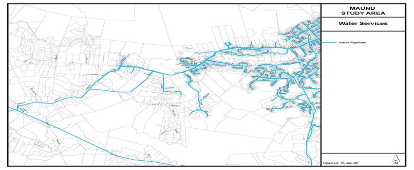
Maunu and Hora Hora Structure Plan

1.6.2 A District which is safe and crime-free.
Structure Plans indicate areas where new neighbourhoods will grow and those which will receive new
investment. This new activity and investment enhances security by encouraging pedestrian traffic in
commercial areas, increasing diversity, giving people new pride in their communities, and encouraging
families to use community facilities close to home
1.6.3 A Community which is healthy and educated
Structure Plans guide planning for new schools and community centres to areas where families are likely to
settle. They also provide for recreational reserves, cycleways and footpaths for an active outdoor lifestyle,
and reduced auto dependence. Preserving natural areas contributes to air quality improvement, provides
respite from urban life, and underlies the District’s high quality of life. Structure Plans also identify areas that
will be serviced so that waste and storm water will be handled in a safe and sanitary manner.
1.6.4 A Vibrant and Growing Local Economy
Structure Plans identify areas that are suitable for business investment based on highway, water, rail and
transit access; concentrations of compatible industries; identifying areas for new housing that is convenient
to jobs; and recognizing growth trends in the District’s major industries while minimising reverse sensitivity
among land uses. By recommending preservation of rural lands, the Plans also recognise the importance of
productive horticulture, agriculture and forestry to the District’s economy.
1.6.5 District with Community Programmes and Facilities for All
Structure Plans identify areas for new residential development where community facilities can be planned to
serve new populations most efficiently. The Structure Plans include population projections to determine
whether existing facilities are adequate for their areas.
1.6.6 A Community which values its Culture and Heritage
Structure Plans take into account the sensitive nature of taonga and waahi tapu and seek to minimize
impacts on it, while increasing knowledge and appreciation of the District’s rich cultural heritage. Focusing
new development around the urban area provides additional support for existing museums, the arts and
tourist amenities. Preservation of environmental qualities – intact landscape, biodiversity, high-class soils,
scenic values and coastlines – is a primary purpose of Structure Plans.

09/2868                                                                                                                8
Maunu and Hora Hora Structure Plan
2 Development Strategy
2.1 Development Goals and Objectives
The recommendations conveyed as part of the Urban Growth Strategy have formed the basis for the urban
structure plans. The Urban Growth Strategy identifies 16 Key Issues that require particular attention to
achieve the vision for Whangarei. These issues have been translated into specific objectives that will need to
be accomplished in order to reach this vision. The objectives are supported by a range of policies and
implementation methods that put these policies into action. Appendix 4, at the conclusion of this document,
portrays a table presenting the entire list of objectives and policies.
Strategic issues for each of the Structure Plan areas were identified in the Urban Growth Strategy. The
following list shows the strategic objectives that apply to the Maunu study area in particular, and presents the
relevant policies.
The characteristic amenity values and the identity of each locality are maintained and enhanced:
To ensure that changes to urban form are compatible with the character, amenity and identity of the
surrounding environment.
Accessible and convenient suburban centres are provided:
To ensure suburban centres are accessible and convenient without detracting from the central
business District.
Establish, maintain and enhance a safe and efficient road network:
To reduce conflicts between heavy vehicles and other users of the roading network
To continue to develop a safe and efficient roading network to meet the demands of urban
development
To minimise the effects of land use and subdivision on the safety and efficiency of the roading network
To ensure adequate provision of parking in the central business District and in suburban shopping
centres.
Public transport, pedestrian walkways and cycleways are provided, maintained and enhanced:
To ensure that safe and effective cycleways are provided within the city, linking to - and between -
suburbs
To promote, develop and improve pedestrian walkways within urban areas
To encourage the further development of public transport services.
The provision of infrastructural services to existing and newly-urbanised areas in an efficient and
effective manner:
To maximise development potential through the efficient provision of upgraded or new infrastructural
services
To avoid damaging environmental resources through ineffective, or lack of, infrastructural services
To provide infrastructure in a way, and as necessary, to ensure the safety and wellbeing of the
community.
The risk associated with natural hazards is not increased by urban development:
To identify areas subject to natural hazards where urban development is likely to occur
To mitigate, where possible, the effects of urban development on the risk of natural hazards
occurring The loss of productive soils and economic farming units is minimised.
The effects of urban-type subdivision on rural character are avoided, remedied or mitigated:
To recognise the value of productive soils and economic farming units to the District’s economy
To minimise the effects of urban-type subdivision on rural amenity
To create a new zone for rural residential use.
Avoid conflict between incompatible land use activities as a result of subdivision and urban
development:
09/2868 9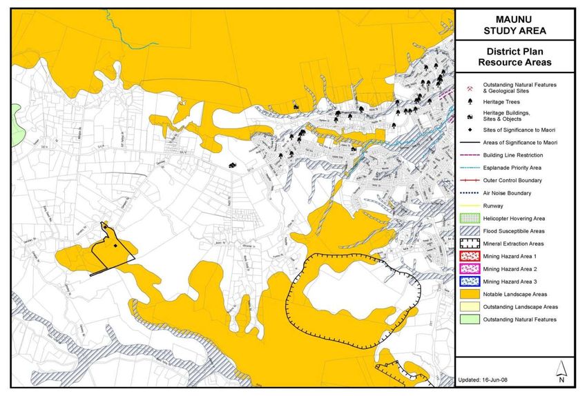
Maunu and Hora Hora Structure Plan
Ensure that subdivision development is located and designed to reduce the potential for conflicts with
the effects of existing activities
To facilitate the separation of incompatible land uses through the location of District Plan
Environments and Resource Areas, and specific requirements of subdivision and land use activities,
e.g. separation distances.
The protection of areas of significant indigenous vegetation and significant habitats of indigenous
fauna.
The protection of the life-supporting capacity of ecosystems through the avoidance, remediation or
mitigation of adverse effects:
To protect significant indigenous vegetation and significant habitats of indigenous fauna from the
effects of urbanisation
To ensure the protection of the life-supporting capacity of ecosystems through avoiding, remedying or
mitigating adverse effects.
Sufficient open space is provided to meet community, conservation and recreational needs:
To provide sufficient open space to meet community, conservation and recreational needs
To ensure linkages are created between areas of existing open space and any new areas created.
Form a partnership with Tangata Whenua that enables effective participation by Tangata Whenua in
planning processes:
To establish consultation protocols with Tangata Whenua which are agreed to by all parties
To improve the relationship between Council and Tangata Whenua.
The prevention of the degradation and loss of historic and cultural sites of significance from urban
development:
To prevent urban development occurring in locations, or in a manner, that will have adverse effects on
sites of significance to Tangata Whenua. To avoid, remedy or mitigate the adverse effects of urban
development on heritage areas significant to Maori and on Sites of Significance to Maori
To encourage the development of a procedure for the identification and recognition of sites of cultural
significance to Tangata Whenua
To protect historic places, sites (including archaeological sites), buildings and trees from the adverse
effects of urban development and subdivision
Access to recreational, artistic and cultural opportunities is enhanced as a result of urban growth:
To encourage the provision of education and employment opportunities
To encourage the provision of recreational, artistic and cultural opportunities.
2.2 Strategic Options
Council has a legal responsibility to manage future growth and development of the District, and it has several
tools at its disposal to do this. These are:
Develop plans and policies to guide development to maximise quality of life and minimise impact on
neighbours and the environment
Enact subdivision regulations that control the specifics of section sizes and layout, guide provision of
public infrastructure and ensure health and safety of the District’s residents and businesses; or
Do nothing and allow each individual free choice in determining what, where and when development
takes place.
Council has chosen to develop plans such as this one, in combination with subdivision regulations, in the
recognition that the private market serves the District by providing living and job opportunities to its citizens.
Such policy documents as this Structure Plan and other policy plans facilitate:
Co-ordination of development, over time, to sustain the District’s unique identity, its economy and
neighbourhoods
Efficient investment of the public’s resources for new infrastructure
09/2868 10Maunu and Hora Hora Structure Plan
A degree of predictability for residents and developers as they make location and investment
decisions; and
The participation of citizens in their government’s decision-making.
This Plan has been prepared to create a better living environment for the residents of Whangarei District.
What follows is a detailed explanation of the existing situation and proposed changes for this study area.
2.3 Spatial Development Strategy
The overall proposed Spatial Strategy is based on the following broad directions:
Providing a progression of living environments, beginning with medium-density urban areas and then
to rural-residential zoning on fringes of urban areas, and retaining rural zoning beyond the rural-
residential zone
Recognising that there need to be restrictions on urban and rural residential development in sensitive
ecological, geological and landscape areas
Recognising that there need to be restrictions on urban, rural residential and commercial development
in areas subject to natural and man-made constraints e.g. instability areas, flood prone areas,
contaminated sites and aquifers
Developing a commercial node to serve the community, (e.g. a supermarket, doctor’s rooms,
butcher’s, fruit and vegetable and bakery shops) and allowing for more linkages to the CBD via an
efficient roading network and an effective public transport system
Providing for a network of pedestrian and cycle links throughout the study area to attractions such as
Pukenui Forest and to surrounding suburbs and the city.
09/2868 11Maunu and Hora Hora Structure Plan
3 Current Profile
3.1 Regional and District Context
The Whangarei District covers the south-eastern part of the Northland region. Whangarei is a growing city of
over 48,000 people within a District of approximately 74,250 people. About half of the total Northland
population lives in the Whangarei District and Whangarei City is the largest urban centre in Northland.
Whangarei District is less dominated by urban growth than Auckland and other regions in New Zealand.
About 65 per cent of the District’s residents live in the urban centre of Whangarei. However, two out of three
new residences are being built outside the urban centre.
The economy of the Whangarei District has been steadily growing in recent years. The leading growth
industries are agriculture, forestry, wood processing, healthcare, tourism, fishing, property and business
services and education.
In October 2003, Whangarei District Council adopted the Whangarei Urban Growth Strategy. This document
recognised the need to manage growth sustainably in the District. The following vision for Whangarei was
adopted:
To be an accessible green city, where people can live, work and shop in safe and clean
surrounds, where art and culture are celebrated, and leisure opportunities abound.
The Urban Growth Strategy recognises the influence of national and regional strategies and policies. The
Regional Policy Statement for Northland, the Regional Coastal Plan for Northland, the Regional Water and
Soil Plan for Northland and the Regional Land Transport Strategy are identified as having significant
relevance.
The Maunu/Hora Hora area was one of eleven identified in the Urban Growth Strategy as requiring structure
planning to plan for and manage growth. At the time of this Plan’s writing, the Maunu/Hora Hora Structure
Plan is being prepared simultaneously with four other urban fringe Structure Plans - Kamo, Otaika, Tikipunga
and Onerahi - along with ten Structure Plans for coastal areas. While each plan is a stand-alone document
for its area, all of the plans must be considered in the context of general growth trends of the Whangarei
District as a whole. This means that recommendations for each Structure Plan area may have been made
with consideration of conditions or changes for the other Structure Plan areas. District sustainability and
integrated management can only be achieved by upholding a broader vision.
Six additional Urban Structure Plans will be prepared in the future.
3.2 Profile of Study Area
3.2.1 Historical Background
The original settlement of Whangarei began with the Nga Puhi tribe, who were descended from the voyagers
of the Mamari Canoe that arrived at the Hokianga Harbour to establish the Tangata Whenua of the north.
It is recorded that a Maori explorer, Tapere, with his lieutenant Maunu, first discovered and named the two
adjacent volcanic cones, Tapere and Maunu.
The Maunu plateau was occupied by Europeans much later than other areas around Whangarei, as there
was a chain of Maori hapu living from Raumanga to Poroti. The chief of all these hapu was Taurua Kukupa.
Identified Maori heritage sites and archaeological sites illustrate the heritage and cultural values of the wider
Maunu area.
In the 1870s the first European settlers arrived. These included the Clearys, the Secombes and Mathew
Armstrong. General farming and dairying were the main industries of the early Maunu European settlers from
the 1890s. The Maunu area is now characterised by stone walls that were made from volcanic rocks that
were collected and cleared from the land to allow for that farming, with the earliest walls dating back to 1850.
Many of these stone walls were built by the Dalmatians during World War I and the Depression, when work
ran out on the gum fields.
Maunu School was opened in 1884, while St John’s Anglican Church was dedicated in the early 1900s.
In 1894, Whangarei’s first hospital was built in Hora Hora. The current hospital stands on the same site.
In the 1980s, Whangarei District Council purchased land to relocate the Agricultural and Pastoral Society
Show and other animal-related events from Kensington Park. This land is now known as Barge
Showgrounds.
09/2868 12Maunu and Hora Hora Structure Plan
The Maunu area is bounded to the north by a number of reserves, including the Millington Road Reserve,
Pukenui Forest Park, Water Supply Reserve and the Coronation Reserve.
Today, Maunu and Hora Hora are suburbs of Whangarei, with medium-density residential living closer to
Whangarei City and rural-residential and rural living further out towards Maungatapere.
3.2.2 Population
In 2006, the population of the Maunu area was 4,749 (Figure 2), with approximately 1,955 dwellings, giving
an occupancy rate of 2.4 people per household. Since then there has been a steady increase in the
population of the area.
The jump in population shown in Figure 1, between the 1986 and 1991 censuses, resulted from a change in
the recording of population numbers. Because the City and County Councils amalgamated in 1989 to form
the Whangarei District Council, population statistics were then collected for the Maunu area which had
previously been part of a larger rural area and not included in the earlier figures.
Figure 2 Maunu-Hora Hora Population
Maunu-Horahora Population
5000
Number of People
4000
3000
2000
1000
0
1966 1971 1976 1981 1986 1991 1996 2001 2006
Census Year
Source: Statistics New Zealand 2006
3.2.3 Natural Features
a Topography and Landscape
The landscape of the study area has various important amenity values and contains areas of ecological
significance. For instance, in the more rural Maunu area the gently undulating countryside is characterised
by stonewalls and patches of bush.
The dominating landforms in the area are Maunu Mountain and the ridges that contain the Western Hills
Forest. Areas to the south of the study area are also quite steep.
The study area roughly comprises the catchments of the Kirikiri Stream (which flows into the Waiarohia
Stream), and the Te Hihi, Nihotetea and Waipounamu Streams (which flow into the Raumanga Stream).
Significant fingers of bush extend south from the Pukenui Forest and link with vegetation associated with the
Te Hihi Stream. Elsewhere, scattered pockets of bush exist, particularly in the southern and eastern portions
of the study area.
The Whangarei District Landscape Assessment (LA4, 1996) describes the majority of this area as a Heritage
Landscape. The northern edge of the study area includes a portion of the Pukenui Forest. The assessment
notes that the construction of telecommunications masts and mining in the foothills of Pukenui Forest is
having an appreciable impact on the natural appearance of the bush, both of these activities being highly
visible.
When considering the study area in more detail (Landscape Assessment, 2004), it is considered that there
are eight distinct character areas.
These are:
Pukenui Bush Upland
09/2868 13Maunu and Hora Hora Structure Plan
Pukenui Undulating Vegetated/Pastoral Mix
Puriri Park Urban Fringe
Westwood Lane Vegetated/Pastoral Urban Fringe
Te Hape Urban
Maunu Road Undulating Vegetated/Pastoral Mix
Pompallier Undulating Vegetated/Pastoral Mix, and
Cemetery Road Undulating Vegetated/Pastoral Mix.
The visual quality, capability for visual absorption and the opportunities and constraints for these eight
character areas is shown in the following table.
In summary
The topography of the area allows opportunities for residential and commercial/industrial use
Parts of the area that contain sensitive environments, such as high-value landscapes and natural
hazards, have been identified and need to be considered in planning for the area
The Puriri Park area has the highest capability to absorb development, visually. However, it is
currently considered to have low visual quality
The Westwood Lane and Cemetery Rd areas have moderate-to-high capability to absorb
development, visually.
b Land capability Classification
To enable an assessment of the land’s versatility for sustained production, and its total degree of physical
limitation, soils are grouped into land use capability classes (LUC). The classes range from I to VIII.
As a guide, limitation is nil or negligible in Class I, so the land there is highly productive. At the other end of
the range, the extreme limitation of Class VIII means production is very limited.
The study area has a mixture of areas of highly productive land (LUC 1-2), moderately productive land (LUC
3-4) and less productive land (LUC 6-7). (Figure 3).
The flat-to-gently undulating areas on either side of State Highway 14, and down Cemetery Rd, are the most
productive (LUC 1-2). The areas of land around Austin Rd and Te Hape Rd are LUC 1, highly fertile and of
limited extent in the Northland region. Soils include red and brown loams and are suitable for a range of land
uses including grazing, cropping and production forestry.
Areas of LUC 3 and 4 are less flat and occur adjacent to the areas mentioned, above, as well as around the
lower part of Austin Road. Soils in these areas include brown and red loams, yellow-brown earth, brown
granular loams and clays. Possible land uses also include grazing, cropping and production forestry.
The steeper areas (LUC 6 and 7) in the study area occur to the north toward the Pukenui Forest, to the west
around the Raumanga Stream, to the lower south and a small area to the east. Soils include yellow-brown
earths, recent soils, gley, and brown and red loams. Land use is limited to grazing and production forestry,
and limited production forestry for erosion control in LUC 7.
09/2868 14Maunu and Hora Hora Structure Plan Figure 3 Land capability Classification 09/2868 15
Maunu and Hora Hora Structure Plan
c Geology
The soils are, on the whole, a result of the weathering of the underlying (parent) rock. There are five
dominant groups of geological material in the Structure Plan area, these are:
Waipapa Group a strong, shattered greywacke and argillite which outcrops in the east of the
area
Te Kuiti Group consists of Whangarei Limestone, and Ruatangata Sandstone
Northland Allochthon a mixture of sheared and crushed, or calcareous and siliceous mudstones,
siltstones, sandstones, muddy limestones (marls) and limestones that
outcrop in the east of the area
Kerikeri Volcanic Group mostly basaltic lava with some scoria cones
Holocene sediments typically alluvium in low lying areas, valleys and palaeovalleys.
Much of the upper slopes and ridgelines of the Western Hills are underlaid with the greywackes and argillites
of the Waipapa Group origin. In general, the Waipapa Group weathers to a soil mass (or regolith) of very stiff
to hard gravel- and clayey silts. The residual soil derived from these materials (typically very stiff, silty clays
and clayey silts) tends to contain non-swelling clays (i.e. they are not subject to large changes in volume due
to changes in moisture content). This, together with a relatively high-strength underlying rock mass and
groundwater that is usually deeper than five metres, means that the introduction of effluent should induce
less slope instability problems than other lithologies.
In the Maunu area, the Waipapa Group has weathered to clay loams and stony clay loams. These are
generally imperfectly drained but are fairly stable and have a moderate potential to accept effluent.
Of the Te Kuiti Group, Ruatangata sandstone and Whangarei Limestone can be found in the study area. The
Ruatangata sandstone weathers to clays and clay loams which provide a poor and moderate effluent
disposal potential, respectively. The parent rock, itself, is of sufficient porosity and permeability to be a fairly
good aquifer. However, Ruatangata sandstone is the least stable of the Te Kuiti Group, and although there
are areas where the sandstone forms steep bluffs, there are others where the sandstone has weathered and
landslides have occurred.
Several patches of Whangarei Limestone also exist in the study area that weather to a heavy clay. Any joints
that form in the rock also tend to be infilled and coated with clay and silt soils. The infill can result from the
weathering of the limestone, itself, or from the collapse of other overlying sediments into the large fractures
in the limestone.
Groundwater lies at a relatively low level within the limestone due to the high rock mass fracture permeability
provided by the open-to-cavernous joints within the strata. Whangarei Limestone tends to act as a natural
under drainage layer, and therefore may have a strong controlling influence on the groundwater regime.
The soils derived from the Northern Allochthon include clays and clay silt. These soils have a tendency to be
poorly drained, and are also generally highly plastic and of low material shear strength. This is due to the
shear fabric of the parent material being preserved in the soil mass, creating defects.
These soils have a very poor effluent disposal potential, particularly the clays. This is due to a low ability of
the soil to take up the liquid that is introduced and the ground may be further destabilised by the introduction
of fluids.
The remaining areas of the study area are Holocene alluvial sediments which are the result of estuarine and
fluvial deposits during the Holocene age and generally cover low lying ground. The silty clays and clays
loams that have developed have a fairly poor effluent disposal potential.
The Maunu volcanic cone, which is just outside the study area’s western boundary, is noted as an important
geological landform.
09/2868Maunu and Hora Hora Structure Plan Figure 4 Maunu Area – Geology 09/2868 17
Maunu and Hora Hora Structure Plan

d         Hydrology
The Northland Regional Council has identified an aquifer within the study area that has a high actual or
potential demand for water extraction. The term ‘aquifer’, which comes from the Latin words aqua, meaning
water, and ferre, meaning to bear, describes a porous geological formation that yields water.
There are important considerations for development on and around this aquifer, particularly as there is
potential for the aquifer to be contaminated by effluent disposal and for water extraction o exceed the
recharge capacity of the aquifer. Council has defined two main catchments in the study area for catchment
management purposes: Kirikiri and Raumanga.
The Kirikiri Catchment (Figure 5) lies to the west of Whangarei City, with the Waiarohia Stream catchment
to the north and the Raumanga Stream to the south. The majority of the catchment is in scrub and native
bush. The rolling part of the catchment adjacent to the Kirikiri Stream is largely rural. The lower flat reaches
of the catchment are on the outskirts of the city and are urbanised.
Soils vary from yellow-brown earths, which are generally moderately well drained, to limestone and
mudstone which are less permeable. There are also soft clays, which tend to be unstable even on gentle
slopes.
Figure 5      Kirikiri Catchment

                                     Source: Kirikiri Catchment Drainage Plan, BECA, April 2001

The Raumanga Catchment (Figure 6) lies to the south of the Kirikiri Catchment. The major streams
discharging into the Raumanga Stream are the Te Hihi, Nihotetea, Waiponamu and Kirikiri Streams.
Raumanga Falls is a waterfall of scenic attraction, and there is also a waterfall on Te Hihi Stream.
The catchment is predominately rural, with some areas of native bush protected as scenic reserve in the
southern extremity of the catchment. This catchment provides a water supply to the north. The lower flat

09/2868
Maunu and Hora Hora Structure Plan
catchment areas, and areas in the Raumanga Stream valley, are urbanised. Soils in this catchment vary
from yellow-brown earths, which are generally moderately well drained, to silt and clay loams which are
generally well drained.
Figure 6 Raumanga Catchment
Source: Raumanga Catchment Drainage Plan, BECA STEVEN, May 1999
The District Plan classifies flood-susceptible areas in the study area. These follow streams and major water
courses. The Kirikiri and Raumanga Catchment Management Plans recommend measures to address
flooding within the catchments.
The Plans also recommend measures to address erosion within the catchments, including:
restricting cattle from stream banks and channels
planting stream banks with non-invasive plant varieties
continuing erosion control works such as gabion baskets; and
inspection and assessment of problem areas after significant storms and/or annually.
09/2868 19Maunu and Hora Hora Structure Plan
With regard to storm water quality, the Plans recommend:
introducing water quality management techniques and commencing willow eradication and in-channel
vegetation removal
planting riparian margins as willow/vegetation removal progresses downstream
requiring source controls and development controls on all new developments and subdivisions
liaising with Transit NZ regarding storm water controls on SH1 and SH14; and
implementing source controls on existing commercial sites as retrofits, where practicable.
e Vegetation
The study area is identified as a modified agricultural, residential and commercial landscape and has been
largely cleared of native bush.
There are a few larger areas of native forest around the volcanic cones, as well as smaller pockets scattered
around the area. The northern boundary of the study area borders the Pukenui/Western Hills Forest, which
contains a large area of native bush.
To the south of the study area, and beyond the southern boundary, is the Otaika Reserve which also
contains native forest.
f Ecology
Ecological areas have been identified as part of the Protected Natural Area Network. While the priority areas
for protection are those containing volcanic broadleaf forests, freshwater wetlands, riverine flood forests,
estuarine systems and areas of kiwi habitat, other habitats throughout the wider urban area are also
recognised in the Protected Natural Area Study.
The aim of the Protected Natural Area Programme (PNAP) is to identify, by a process of field survey and
evaluation, natural areas of significance throughout New Zealand, so as to retain the greatest possible
diversity of landform and vegetation patterns (and, thereby, habitats).
To achieve this, representative biological and landscape features that are common or extensive within an
Ecological District are considered for protection, as well as those features that are special or unique.
The study area has several significant areas of bush as well as remnant patches of bush. Pukenui Forest is
partly included on the northern side of the study area, and is a very large area of bush that contains a high
density of vegetation types. It is habitat for kiwi and other threatened and common bird species, as well as
the long tailed bat. The forest is also part of the catchment for the Whau Valley dam.
The south-eastern part of the study area includes Raumanga Valley, which contains riverine vegetation and
kowhai – karaka forest. It is habitat for threatened bird species, a regionally significant plant species (hard
beech), as well as the long finned eel.
On the southern boundary of the study area is the Otaika Valley Bush, a diverse and large area of forest that
provides habitat for a number of threatened bird species, including kiwi and fresh water fish species.
Bush remnants in the study area contain volcanic broadleaf forest and swamp/riverine forest that are habitats
for threatened bird species.
The Structure Plan study area is in the Whangarei Ecological District. The following PNAP areas are found
within study area:
07/022 Pukenui Forest
07/023 Otaika Valley Bush
07/048 Raumanga Valley
07/055 Millington Road Remnants
07/056 Cemetery Road Remnants
07/060 Te Hihi Stream
09/2868 20Maunu and Hora Hora Structure Plan
g Land Use and Zoning
The land use pattern of the study area is influenced by topography, geomorphology, climate, historical
elements and proximity to Whangarei City.
The zoning of the study area reflects current and future land use. The current District Plan zoning is depicted
in the map below.
Broadly, the land use/zoning pattern is characterised by:
Residential development around the hospital and ribbon development along State Highway 14
Rural-residential development occurring about three and half kilometres from the State Highway 1
turnoff, especially around Austins Road, Millington Road, Cemetery Road and Gulf Harbour Drive
Commercial development in the form of suburban shops at the corner of West End Avenue and
Maunu Road and at Tui Crescent.
There is no industrial-zoned land in the area, although some self-employed contractors and timber
processors do operate in the area.
h Residential
There are two residential zonings or Environments in the study area:
Living 1 Environment – general urban areas with a minimum lot size of 500m2, where connected to
reticulated sewerage.
Living 3 Environment – larger lot residential areas where development is restricted due to the physical
nature of the land, a lack of infrastructure or because of landscape or other values of the area.
Minimum lot sizes are 2000m2.
The residential area occurs from the intersection with State Highway 1 for about three and a half kilometres
along State Highway 14, and along the hillside suburbs that are accessed from the State Highway.
There is also land zoned for large residential lots’ development. Those areas zoned Living 3 Environment
occur to the north of State Highway 14, up towards Pukenui Forest, and in an area to the south of State
Highway 14 around Austin Road and behind Kiwi Avenue and Kotare Crescent.
It is difficult to define the extent of rural-residential as there are many sites of a size that may be considered
rural-residential (i.e. less than two hectares) which are currently zoned rural, in particular areas around
Pompallier Estate Dr, Austin Road, Golf Harbour Drive and Cemetery Road.
i Retail/Commercial
There is only one Business Environment applying to the study area:
Business 3 – the shopping centres outside the CBD, as well as commercial areas that are in close
proximity to Living Environments. Minimum lot size is 100m2.
There are two retail areas in Maunu, a reasonably-sized group of shops at the corner of West End Avenue
and Maunu Road and a smaller group of shops at the corner of Tui Crescent and Maunu Road.
There is also a land-locked area of commercially zoned land that was rezoned for a tourist venture that never
eventuated.
j Social, Community and Iwi Facilities
There are five schools in the study area: Hora Hora and Maunu Primary Schools, Blomfield Special School
and Resource Centre, Northland Health Camp School and Pompallier College. There is also Maunu Road
Pre-School and Baby Centre, and the Hora Hora Playcentre.
The Museum and Heritage Park and Barge Showgrounds are also in the study area. The showgrounds host
the Whangarei Riding Therapy Centre, the Maunu Pony Club, the A&P Show and other shows.
The Hora Hora Rugby Union Football Club and the Sherwood Park Golf Club are also present in this study
area, as well as several places of worship.
There are several marae that provide meeting places for the Tangata Whenua, including the Central
Whangarei Marae and Terenga Paraoa Marae.
09/2868 21Maunu and Hora Hora Structure Plan
There is only one medical centre in the area, but the Whangarei Hospital is also in the study area, as is the
cemetery. Several retirement villages and veterinarians are located here, but apart from the Accident and
Emergency Department at the hospital, there are no emergency services stationed in the Maunu area.
In summary, a range of activities exist in Maunu, although more facilities could be developed in and around
the area, such as another commercial centre to service the rapidly growing rural-residential area.
k Open Space and Recreation
There is a single recreation/conservation Environment in the study area.
Open Space Environment covers land owned by Council, the Department of Conservation or other
organisations for recreational and conservation purposes.
Open Space Environments are scattered throughout the study area and include active and passive
recreation areas and esplanade reserves:
Some of these are large areas of land including Pukenui Forest. Others are small neighbourhood
parks dotted among the residential areas
The Hora Hora Sportspark on Te Mai Road has rugby and touch rugby clubs
Sherwood Park Golf Course is off Millington Road
Barge Showgrounds, which has already been mentioned above, is a large recreation area managed
by the A&P Society. Many events are held here, including sporting (e.g. equestrian events) and
social/cultural (e.g. the Wine & Food Festival).
09/2868 22Maunu and Hora Hora Structure Plan Figure 7 Current District Plan Map 09/2868 23
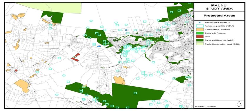
Maunu and Hora Hora Structure Plan

Figure 8      Protected Area

09/2868                              24
You can also read