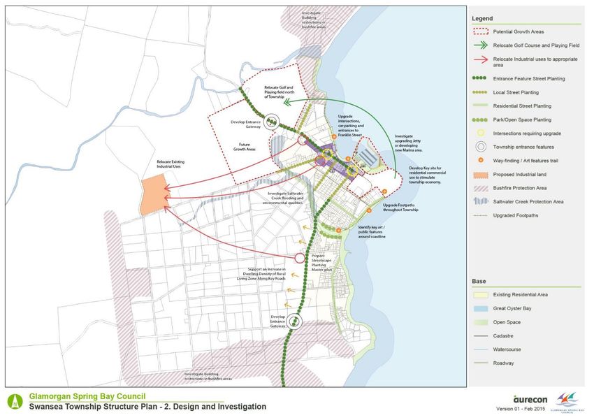
Swansea Township Structure Plan
←
→
Page content transcription
If your browser does not render page correctly, please read the page content below
Choose a building block.

                                          Swansea
                               Township Structure Plan

Master Plan
April 2016
Document control record
Document prepared by:
Aurecon Australasia Pty Ltd
ABN 54 005 139 873
Aurecon Centre
Level 8, 850 Collins Street
Docklands VIC 3008
PO Box 23061
Docklands VIC 8012
Australia

T       +61 3 9975 3000
F       +61 3 9975 3444
E       melbourne@aurecongroup.com
W       aurecongroup.com

A person using Aurecon documents or data accepts the risk of:
a)      Using the documents or data in electronic form without requesting and checking them for accuracy against the original hard
        copy version.
b)      Using the documents or data for any purpose not agreed to in writing by Aurecon.

Document control

Report title                      Swansea Township Structure Plan

Document ID                       Structure Plan                      Project number                  243307

File path                         C:\Users\alistair.noble\Desktop\Swansea Structure Plan.docx

Client                            Glamorgan Spring Bay                Client contact                  Shane Wells
                                  Council
Rev       Date                    Revision details/status             Prepared by       Author        Verifier            Approver
1         12 February 2015        Draft 1.0                           M Howard          M Howard      A Noble             J Griffith

2         19 March 2015           Draft 1.2                           A Noble           A Noble       M Howard            J Griffith

3         6 May 2015              Submitted to Client                 A Noble           A Noble       M Howard            J Griffith

4         3 February 2016         Final                               A Noble           A Noble       M Howard            J Griffith

5         8 April 2016            Final edited by GSBC

Current revision                  5

Approval

Author signature                                                      Approver signature

Name                              Alistair Noble                      Name                            Jules Griffith

Title                                                                 Title                           Associate – Planning
                                  Senior Planner
                                                                                                      Team Leader

                                                                                                  Swansea Structrue Plan 4 February 2016 Revision 5
Swansea Structure Plan

              Date 4 February 2016
              Reference 243307
              Revision 5

              Aurecon Australasia Pty Ltd
              ABN 54 005 139 873
              Aurecon Centre
              Level 8, 850 Collins Street
              Docklands VIC 3008
              PO Box 23061
              Docklands VIC 8012
              Australia
              T   +61 3 9975 3000
              F   +61 3 9975 3444
              E   melbourne@aurecongroup.com
              W   aurecongroup.com

                                 Swansea Structrue Plan 4 February 2016 Revision 5
Contents
1   Introduction                                                                                        2
    1.1   Project Aims                                                                                  2
    1.2   Structure Plan Process                                                                        4
    1.3   Vision                                                                                        5
    1.4   Project Team                                                                                  5
2   Existing Context                                                                                    6
    2.1   Introduction                                                                                  6
    2.2   Regional Transport Links                                                                      7
    2.3   Regional Attractions and Landscape Features                                                   8
    2.4   Regional Natural Features                                                                     9
    2.5   Regional Natural Hazards                                                                    11
    2.6   Aboriginal Heritage                                                                         14
3   Township Profiles                                                                                 15
    3.1   Swansea – Township Profile                                                                  15
    3.2   Community Population profile                                                                28
4   Community and Stakeholder Engagement                                                              31
    4.1   Summary of Community Engagement (December 2014)                                             31
5   Strategic Context                                                                                 33
    5.1   State                                                                                       33
    5.2   Regional                                                                                    33
    5.3   Local                                                                                       34
6   Opportunities and Constraints                                                                     39
    6.1   Swansea                                                                                     39
    6.2   Motorhome, Caravan and Camping Visitors                                                     49
7   Themes and Principles                                                                             50
    7.1   Swansea - Themes and Principles                                                             50
8   Structure Plan Options                                                                            55
    8.1   Identification of Options                                                                   55
    8.2   Assessment of Options                                                                       56
    8.3   Recommended Option                                                                          58
9   Structure Plan                                                                                    59
    9.1   Introduction                                                                                59
    9.2   Residential Land Uses                                                                       59
    9.3   Town Centre and Gateway Treatments                                                          61
    9.4   Industrial Land Uses                                                                        62
    9.5   Tourism Land Uses                                                                           62
    9.6   Community Land Uses                                                                         63

                                                            Swansea Structure Plan 4 February 2016 Revision 5 Page i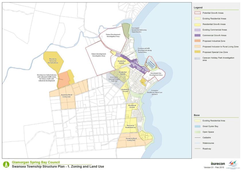
9.7   Movement Network                                                                       64
     9.8   Urban Design Principles                                                                64
     9.9   Infrastructure Initiatives                                                             65
     9.10 Future Character Statements                                                             65
10   Consultation                                                                                 66
     10.1 Public Exhibition                                                                       66
     10.2 Submissions                                                                             66

Appendix
Appendix A – Master Plans

Table 1 Swansea Soil Types                                                                        20
Table 2 Swansea Recreation and Community Facilities                                               24
Table 3 Swansea Heritage Sites                                                                    26
Table 4 Population Data                                                                           28
Table 5 Dwelling Type                                                                             30
Table 6 Population Growth                                                                         30
Table 7 Strength and Weaknesses                                                                   39
Table 8 Opportunities and Threats                                                                 44
Table 9 Existing Land Use                                                                         50
Table 10 Vacant Land                                                                              51
Table 11 Swansea Growth Rate                                                                      51
Table 12 Unoccupied / Seasonal Dwellings                                                          51
Table 13 Swansea Options                                                                          58

Figure 1 Regional Context                                                                          6
Figure 2 Regional Road Network                                                                     7
Figure 3 Local Roads and Transport Links                                                           8
Figure 4 Regional Attractions and Landscape Features                                               9
Figure 5 Landslip Hazards Swansea                                                                 11
Figure 6 Sea Level Rise Predictions                                                               13
Figure 7 Swansea Structure Plan Boundary                                                          15
Figure 8 Swansea Local Road Networks                                                              17
Figure 9 Swansea Reticulated Water System                                                         18
Figure 10 Swansea Sewerage System                                                                 19
Figure 11 Swansea Zoning (prior to August 2015)                                                   21
Figure 12 Lots without Dwellings                                                                  22
Figure 13 Recreation and Community Facilities                                                     25
Figure 14 Heritage Listed Sites                                                                   27
Figure 15 Population by Age                                                                       29
Figure 16 Number of Residents per Dwelling                                                        30
Figure 17 Original (pre 2015) Planning Zones                                                      37
Figure 18 Interim (August 2015) Planning Zones                                                    38

                                                       Swansea Structure Plan 4 February 2016 Revision 5 Page ii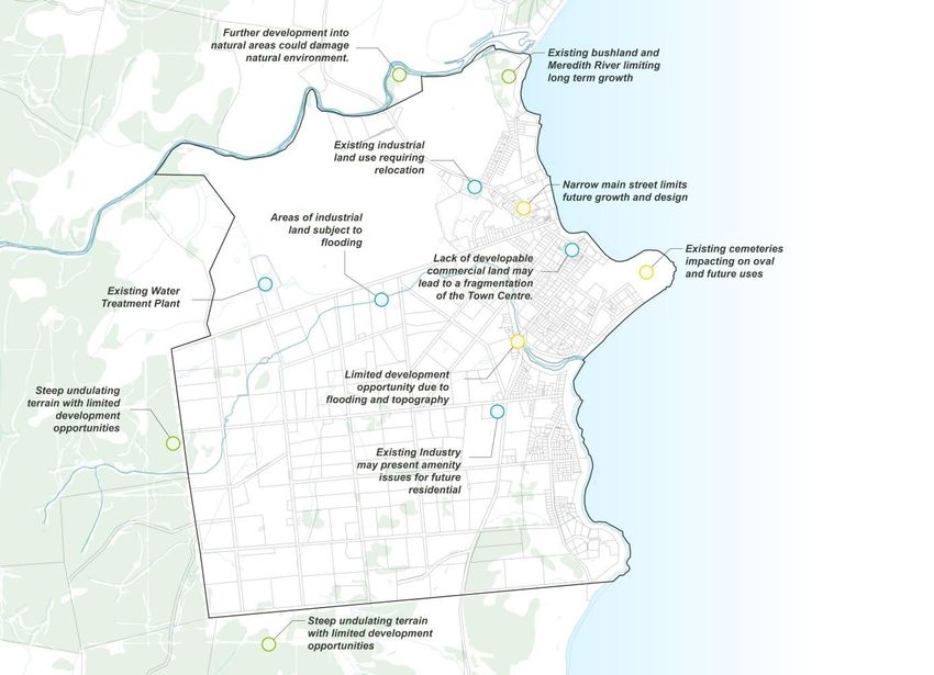
Executive Summary

In 2014, the Bicheno and Triabunna & Orford Structure Plans were prepared and approved by the
Glamorgan Spring Bay Council. These Structure Plans provide a vision and recommended actions for
land use, transport, built form and public spaces in the respective towns over the next 20 years.
The Council has now identified the need to prepare a structure plan for the Swansea Township. The
aim of this plan is to identify a future vision for land use and development in the central region of the
Council. The area will greatly benefit from the provision of a structure plan, providing future direction
for growth and development.
The community has a distinct character set within a highly desirable coastal settings. The combination
of natural and heritage assets, community facilities and attractions make Swansea an appealing
destination for tourists and an attractive place to work and reside.
Along with directing future growth, the Structure Plan will seek to ensure that township entrances,
activity precincts, key public open spaces and linkages are protected against inappropriate
development and maintain a high level of visual amenity, pedestrian amenity and safety. The structure
plan process examines the streetscape character and urban design features for key areas. It will
provide high level advice on areas for improvement, in line with best practice urban design and safe
design principles.
The preparation of the Structure Plan requires identifying local needs, values and expectations; in
order to establish the key issues that affect the township. This involves a two-way relationship in which
information is conveyed. The views and inputs of affected residents, businesses and visitors are
sought on issues, projects or developments that affect them directly - or in which they may have a
significant interest.

                                                                          Swansea Structure Plan 4 February 2016 Revision 5 Page 1
1            Introduction

1.1          Project Aims

The Glamorgan Spring Bay Council is creating a Structure Plan for Swansea that will provide a 20
year blueprint to guide the development of the township. The Structure Plan will provide a vision for
future land use and development within Swansea to 2035 and will provide a basis to align planning
scheme provisions and zoning, infrastructure provision and local services within a modern and
integrated framework.
This document outlines the structure planning process and identifies a preferred land use and
development strategy for the study area of Swansea. The plan discusses the regional context of the
area however does not specifically address the land use framework for the local government area as a
whole. A number of infrastructure elements that are identified in strategic planning documents have
been considered in the preparation of the Structure Plan.
The Structure Plan is a framework to guide future land use planning and provision of infrastructure and
community facilities. It contains detailed investigations of the projected development capacity of the
area and confirms land use suitability and infrastructure requirements for future development.
The Structure Plan will not rezone the land; rather it provides a direction for land use and transport
planning at a strategic level. The Structure Plan will be further developed and refined based on
feedback received during the exhibition process.
A Structure Plan provides a framework for the coordinated provision and arrangement of future land
uses, subdivision and development in new urban areas (greenfield sites) and in existing
developed/redevelopment areas (brownfield sites).

        A Structure Plan is a strategic document that guides the planning of new areas of
        settlement (and also for retrofitting existing areas) in terms of infrastructure and road
        and pathway connections improving access by walking, cycling and public transport,
        raising densities and introducing local shopping and a greater mix of uses.
        http://www.planning.tas.gov.au/the_planning_system/local_area_planning Accessed on 18-8-2014

                                                                                 Swansea Structure Plan 4 February 2016 Revision 5 Page 2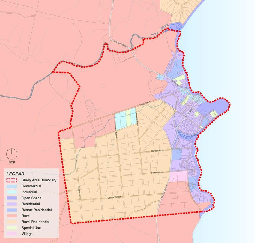
1.1.1 Role of the Structure Plan
The Structure Plan will provide a high level planning framework and guide how growth will occur in
specific areas within Swansea. The Plan sets directions for future land use to accommodate projected
population growth. It maps where housing, retail, commercial, industrial and community uses of land
will be located and what infrastructure (e.g. roads, water, sewerage, gas) and services (e.g. health,
education) are needed to complement growth.
The aim of the Structure Plan is to:
Create a framework for Swansea for future growth of residential, commercial and industrial land
uses for the next 20 years.
Carry out the recommendations of the Southern Tasmania Regional Land Use Strategy 2010-
2035 and other regional framework documents.
Investigate and provide recommendations to revitalise existing commercial zones within the
townships.
Identify large-scale development opportunities around Swansea..
Highlight gaps in community services and facilities and prepare recommendations to address
these.
Identify Urban Design principles to enhance the local centres and provide a high level of
amenity for residents and tourists.
Identify key tourist functions of the region and sustainable development to the tourism industry.
The Structure Plan also identifies the following objectives:
Protect the natural environment and ensure that threatened flora and fauna are not impacted
upon by development of land.
Ensure infrastructure has the capacity to sustain future proposed growth.
Provide for greater opportunities of employment through development of services and retail.
Identify key pedestrian and cycle links and improve access to alternative modes of transport.
Provide recommendations for future planning scheme amendments to direct growth.
Promote healthy and vibrant townships including access to community and recreation facilities
and high quality urban design.
Stage growth and development areas in a sustainable way to take full advantage of services
and keep defined township boundary.
The plan is a high-level, predominantly strategic, document that will provide guidance on future land
use, employment, density targets and the coordination and provision of major infrastructure within the
town. This may include the refinement of regional land use boundaries, coordination of regional and
district infrastructure provision, location and distribution of regional or district open space, land use
buffers, location of schools or community facilities, district water management requirements,
movement networks, environmental assets and activity centres.
In some locations within the study area land is considered for development that has not yet been
zoned for urban land use and development. In order to develop this land more appropriately, detailed
planning, consultation and investigation is required.
Swansea Structure Plan 4 February 2016 Revision 5 Page 3
1.1.2 Benefits of the Structure Plan
There are wide range of benefits in preparing a Structure Plan for Swansea. These benefits include:
Infrastructure coordination
Land supply monitoring
Efficient subdivision and development approvals
Review and development of planning policy
Guidance
Maintaining and enhancing a sense of place
1.2 Structure Plan Process
The Structure Planning process is detailed below demonstrating the stages this Structure Plan has
been through to become endorsed.
• Project Inception
• Background Investigations
• Stakeholder Workshops
• Identification of Draft Vision and Options
• Working Group Workshop
• Draft Structure Plan
• Public and Stakeholder Consultation
• Final Structure Plan
Swansea Structure Plan 4 February 2016 Revision 5 Page 4
1.3 Vision
The vision for the future of Swansea is:
“Swansea will maintain its coastal town feel that balances the towns existing character with future
growth ambitions. It will continue to provide affordable and diverse living options for residents and
holiday accommodation options for tourists. The town will strive to build on its natural, coastal,
community and cultural assets and continue to benefit from its central location on Tasmania’s East
Coast and the nearby Freycinet National Park.”
Vision East 2030
The report - Vision East 2030 – East Coast Land Use Framework 2009 prepared for the east coast
councils in 2009 outlines a vision for the area and each council as follows:
The East Coast vision is:
“To enhance the community and economic potential of the East Coast,
maintain its natural and cultural heritage assets and values as a living
environment, and establish a hierarchy of service centres with appropriate
transport linkages to the region and between the settlements”
The Glamorgan Spring Bay vision is:
“Increase diverse employment opportunities by encouraging appropriate
development of key towns, whilst protecting residential amenity, unique
environmental features and significant tourism assets”
The objectives and recommended actions in Section 8 provide support for and further these visions.
1.4 Project Team
The Glamorgan Spring Bay Council engaged Aurecon to provide specialist technical advice that would
inform the development of the Swansea Structure Plan.
Swansea Structure Plan 4 February 2016 Revision 5 Page 52 Existing Context
2.1 Introduction
The Swansea area encompasses the northern end of the Great Oyster Bay on the South East
Tasmanian coast. Located within the Glamorgan Spring Bay Council, Swansea is one of three
regional centres along with Bicheno and Triabunna/Orford in the municipality. The area provides
access into the world famous Freycinet National Park and Wineglass Bay via Coles Bay.
Figure 1 Regional Context
Swansea Structure Plan 4 February 2016 Revision 5 Page 62.2 Regional Transport Links
Figure 2 Regional Road Network
The main transport access to the area is via the Tasman Hwy connecting from Hobart, along the east
coast into Swansea and Bicheno, and continuing to Launceston. Swansea is located around 135km
from Hobart and 43km from Bicheno. It is predominantly a surfaced, single carriageway highway
running in a north-south direction along the east coast.
Other major roads in the area are limited with the Lake Leake Road being one of the few connections
through to the Midland Highway
The Swansea area is within reasonable travel distance from Hobart International Airport, which is also
located along the Tasman Highway; approximately two hours to the south.
Busses regularly run from Hobart to Swansea and Hobart to Bicheno providing a vital alternative to car
travel for tourists and residents of the area. Charter services also run between Bicheno and Coles Bay
and into the Freycinet National Park.
Swansea Structure Plan 4 February 2016 Revision 5 Page 7Figure 3 Local Roads and Transport Links
A number of small hamlets exist around the area in a typically rural or holiday setting. These include:
Dolphin Sands, a low density residential area set back from Nine Mile Beach which has recently
seen significant growth. The area has a very beach-bush setting with limited services.
Cranbrook, a rural hamlet to the north of Swansea servicing the housing needs of the nearby
farmland and walnut groves.
Rural access roads throughout the area are single lane rural sealed or gravel roads.
2.3 Regional Attractions and Landscape Features
The Great Oyster Bay area has an array of natural features within close proximity to Swansea and
provides a sanctuary for animals and people alike. The bay is home to an abundance of wildlife
including seasonal whales, little penguins, mutton-birds and shellfish. A number of Marine Farms exist
within the bay and along the estuary area comprising a mix of commercial and tourist ventures
growing oysters, abalone, scallops and mussels.
The Moulting Lagoon Game Reserve and Apsley Marshes are two of Tasmania’s ten listed Ramsar
Wetlands being of major ecological value. Development of these wetlands for recreational, research or
tourism ventures could be further considered however impacts of these must be appropriately
managed. The land use and development of the surrounding land must be carefully managed and
planned appropriately to ensure that no ecological damage transpires to the wetland.
Swansea Structure Plan 4 February 2016 Revision 5 Page 8To the east of Great Oyster Bay is one of Tasmania’s premier natural attractions, the Freycinet
National Park. Accessed from Coles Bay the National Park has a strong following of bushwalkers with
the peninsula walking track. Other nature based activities in the area include boat tours of Wineglass
Bay, kayaking, mountain bike riding and climbing.
Nine Mile Beach around the northern end of the Great Oyster Bay is another great natural attraction
for the area providing one of the longest beaches in eastern Tasmania. The beach provides a frontage
for the Dolphin Sands subdivision and can be accessed from either end and from areas along the
Dolphin Sands Road.
Along the Tasman Hwy to the south of Swansea a number of small conservation areas protect
pockets of the coast allowing public access and car parking.
Figure 4 Regional Attractions and Landscape Features
2.4 Regional Natural Features
2.4.1 Landscape
Swansea is distributed along the coastline where the urban area contains spectacular coastal outlooks
and views over Oyster Bay and over to Freycinet National Park. The coastal outlook and views to the
east are key assets for Swansea.
Swansea Structure Plan 4 February 2016 Revision 5 Page 9To the west are views to the vegetated ranges forming a natural boundary to Swansea, these are of
significant importance to the town. The study area of Swansea adjoins the Meredith River to the north
and with a number of minor creek, streams and waterways draining to the coast.
2.4.2 Flora and Fauna
The area surrounding Swansea holds a huge variety of important ecosystems that are both
environmental, economic and tourism assets. These include the Moulting Lagoon wetlands and
estuaries to the north, the Eastern Tiers ranges encompassing conservation areas, covenanted areas
and state forests to the west, the beachfront dune areas particularly along Nine Mile Beach and the
Freycinet National Park including the neighbouring conservation areas to the east.
Moulting Lagoon is an extremely important area for water birds as it provides nesting and foraging
habitat for a wide range of species, including a large numbers of birds. The area includes about 80%
of Tasmania’s black swan population and 14 bird species covered by the Japan Australia Migratory
Birds Agreement. The area is also home to the Wedge-Tailed Eagle and the Eastern Curlew both
listed as endangered. It is also home to the White-bellied sea-eagle, a vulnerable species’. The
reserves in the Moulting Lagoon area are also home to the Tasmanian devil along with the bushlands
throughout the Freycinet National Park and the Eastern Tiers forest.
Careful planning of the area must ensure that the existing natural habitat is conserved and not
negatively impacted upon by future development.
Areas around Swansea including Waterloo Point, areas around the Meredith River and coastal areas
south of town have high environmental value. A number of these areas include breeding grounds for
shorebirds, shearwater colonies and are frequented by penguins. Protection of these natural features
is vital when assessing any future development opportunities.
Swansea Structure Plan 4 February 2016 Revision 5 Page 102.5 Regional Natural Hazards
2.5.1 Flooding
The region is not identified as being highly prone to major flooding however areas along the Meredith
River, Saltwater Creek and Moulting Lagoon may be subject to localised inundation during high rainfall
events.
2.5.2 Bushfires
Bushfires are a common part of Australian living with long dry summers and highly volatile forests.
Each year a number of out of control fires impact on people’s lives and property around the country
and state and any development in forested areas needs to be appropriately planned and designed to
minimise this risk.
Throughout the northern section of Great Oyster Bay there have been a number of fires both out of
control and planned burns. Recent fires in 2009 claimed 5 homes and a number of sheds in Dolphin
Sands and large fires burned through the Eastern Tiers and around Granite Creek (east of Swanwick)
in 1994. Many other burns have occurred around the Freycinet Peninsula, Dolphin Sands and along
the Coles Bay Road in recent years.
Significant work has been undertaken by the Tasmania Fire Service in conjunction with Council to help
identify and mitigate bushfire risks. This includes weed removal, developing fire management plans
and undertaking risk assessments, particularly around Dolphin Sands but also throughout the other
township areas. The future planning of the area must consider the fire risk and vegetation cover along
with access and water availability.
2.5.3 Land Stability
The general topography of the landform within Swansea is relatively flat. Further to the west of
Swansea a number of the hillsides have been identified as low to moderate landslide risk however
these sites are typically within the forested hillsides with little future chance of development.
Figure 5 Landslip Hazards Swansea
Low (Yellow) and Medium (Orange)
Swansea Structure Plan 4 February 2016 Revision 5 Page 112.5.4 Climate Change
The Regional Councils Climate Adaptation Project prepared a report for the Glamorgan-Spring Bay
municipality in 2011 outlining the impacts of Climate Change on the area over the next century. The
report made predictions on two scenarios. The first worked on the existing increase in greenhouse
gases continuing without dramatic global intervention. The second scenario followed a gradual
reduction of the rate of carbon emissions and a lessening of the impacts of climate change.
Using these scenarios the report projected an average temperature rise of between 2.6 to 3.3°C over
the next century for the higher emissions scenario and between 1.3 to 2.0 °C for the lower emissions
scenario.
The projected change in average temperature is accompanied by a change in the frequency, intensity
and duration of hot and cold extremes of temperature. For the Swansea area, under the higher
scenario by the end of the century the projections indicate:
1. The number of summer days (>25 °C) more than doubles.
2. The temperature of very hot days will increase by more than the average temperature (up to 4
°C in some seasons).
3. Frost risk days will be very infrequent, but still occur occasionally.
4. Warm spells (days in a row where temperatures are in the top 5% of baseline levels) currently
between 4 to 6 days, will last 3 to 5 days longer.
5. An increase in sea temperature at the coast due to the ongoing strengthening of the East
Australia Current is likely to have large impacts to marine and coastal systems.
The long term effects of climate change on the rainfall of the area are predicted to have significant
impact. Based on the higher emissions predictions the municipality is projected to receive up to 20%
more rainfall in the autumn and summer by the end of the century. The projected increase in rainfall is
primarily driven by the increased sea temperatures offshore and this will lead to unpredictability and a
tendency for heavier rainfalls interspersed by longer dry periods. The projections also identify an
increase in evaporation of up to 19%.
Other predictions outlined include an increase in runoff during high rainfall events of up to 30% leading
to increased erosion or flooding.
Swansea Structure Plan 4 February 2016 Revision 5 Page 122.5.5 Sea Level Rise
The Regional Councils Climate Adaptation Project also outlined the predicted sea level changes and
the effects on the Swansea area. The upper range projections indicate a rise of up to 0.82m in sea
level rise by the end of the century. This is a rate of around 3.3 ±0.4 mm/year similar to the rise
experienced in the recent period.
Figure 6 Sea Level Rise Predictions
Swansea Coles Bay Region 0.4-0.8m
The current 100-year storm tide event in Spring Bay is 1.05 m above average sea level. High storm
heights in the southeast are generally brought by westerly cold frontal systems with a low-pressure
system to the south of Tasmania. Changes to storm surges by the end of the century are projected to
be much less than sea level rise. The report outlines that the current 100-year event in Hobart is
projected to be a 1.58 m in Spring Bay by 2090 under the high emissions scenario.
Swansea Structure Plan 4 February 2016 Revision 5 Page 132.6 Aboriginal Heritage
The area around Swansea including Moulting Lagoon was home to the Oyster Bay Tribe prior to
European settlement. The tribe is believed to have had a population of around 600-800 people.
Moulting Lagoon was an important food source for the tribe as was the surrounding bush lands and
foreshore. To date few archaeological surveys have been conducted in the area however eight sites
have been registered on the Tasmania Aboriginal Site Index including middens, quarry sites and
artefact scatters.
It is highly likely that many more sites exist in the area as it is known that the Freycinet
Peninsula/Friendly Beaches area was used extensively by bands of the Oyster Bay Tribe. The vast
shell deposits which lie in the dune swales behind Nine Mile Beach south of Moulting Lagoon have
been identified as being natural but less conspicuous deposits in the same beach/lagoon area have
been identified as Aboriginal sites. (Moulting Lagoon Game Reserve (Ramsar Site) Management Plan
2003.
A historic aboriginal walk has been developed around Waterloo Point (Loontitetermairrelehoiner)
providing an education and insight into the aboriginal culture of the area. Other potential aboriginal
features have been identified around Swansea and future development must respond to and respect
these places.
Swansea Structure Plan 4 February 2016 Revision 5 Page 143 Township Profile
3.1 Swansea – Township Profile
3.1.1 Location and Settlement Structure
Swansea is positioned on the western edge of Great Oyster Bay on Tasmania’s east coast. The town
is predominantly residential in nature and provides small scale facilities for local residents and for
those people living within proximity to the town. During the peak summer holiday season Swansea
becomes a hub for tourists and tourism activities associated with is location on Great Oyster Bay and
its proximity to Freycinet National Park and other popular tourist destinations.
Figure 7 Swansea Structure Plan Boundary
Swansea Structure Plan 4 February 2016 Revision 5 Page 15The Swansea urban area follows the coastline to the east of the town and is bounded by a rising
escarpment which forms the western inland edge of the town. The Tasman Highway is the central
access road through Swansea and links the township with other settlements on the East Coast of
Tasmania.
The settlement stretches along the coastline in a linear form, with waterfront access along the length
of the township providing a direct visual and physical connection with the coast. The linear settlement
structure has been influenced by the coastline and predominant road pattern. . The orientation of the
settlement along the coastline maximises coastal views and outlook towards the water.
Ribbon style residential development is situated along the coast and spreads approximately 4
kilometres from the southern end of Old Spring Bay Road in the south to the Meredith River in the
north.
The subdivision pattern, across most of Swansea’s residential areas, is generally low density
comprising large allotments. Larger rural living style allotments are general located west of the
Tasman Highway and are generally bordered by Catchart Street to the south, Young Street to the
west, Maria Street to the north and the Tasman Highway to the east.
Within Swansea there are a number of vacant areas of land within the boundaries of the township that
are surrounded by or adjacent to developed land, presenting infill opportunities.
The town centre is located from the intersection of Franklin Street and Victoria Street and extends
along Franklin Street for about 350 metres in a north westerly direction. There are limited non-
residential activities located in several streets adjacent Franklin Street including Arnol and Noyes
Streets.
The town centre contains a mix of commercial, residential and community land uses which are
distributed along the street frontages, resulting in a fragmented structure for the town centre. The
fractured commercial centre has resulted in an undefined central focus point for the town.
Whilst the intersection of the Franklin Street and Victoria Street is a natural focal point, it is currently
constrained due to the present traffic management arrangements and the role of Franklin and Victoria
Street as the ‘Tasman Highway’ as the road travels through Swansea.
Built form within the town centre predominantly consists of detached single storey buildings, with some
examples of double storey built form.
Pursuant to the hierarchy of urban settlements identified in the Southern Tasmania Regional Land Use
Strategy 2010-2035 Swansea is designated as a Township with a moderate growth strategy with a
1
Consolidated Growth Scenario.
1
For reference see Table 3:Growth Management Strategies for Settlements (page 85) of the Southern Tasmania Regional Land Use Strategy
2010-2035.
Swansea Structure Plan 4 February 2016 Revision 5 Page 163.1.2 Transport and Access
The Tasman Highway is the main road through Swansea and the principal road providing vehicle
access to Swansea from other settlements along the East Coast of Tasmania.
The predominant mode of transport for access to and within Swansea is via private vehicle. The town
is also serviced by limited tourist operated buses providing connections with Hobart, Launceston and
Coles Bay.
Foreshore walking tracks exists along the coastline of Swansea within proximity of the central
township. Additionally, there is the scenic track from Waterloo Point around the edge of the golf
course that provides panoramic views over Swansea, Great Oyster Bay and Freycinet National Park to
the east.
Figure 8 Swansea Local Road Networks
Swansea Structure Plan 4 February 2016 Revision 5 Page 173.1.3 Services and Utilities Infrastructure
Potable Water
In 2011 the Swansea Water Treatment Plant was upgraded with the inclusion of a 400ML reservoir to
further secure the water supply. Prior to this occasional boil alerts were placed on all tap water. The
upgrades to the treatment plant have now removed the need for boil alerts which were considered a
key limitation on further tourism and residential development in the area.
Figure 9 Swansea Reticulated Water System
Swansea Structure Plan 4 February 2016 Revision 5 Page 18Wastewater
The Swansea Wastewater Treatment Plant was recently upgraded by TasWater providing limited
capacity for the township for future growth.
Figure 10 Swansea Sewerage System
Electricity
The existing electricity infrastructure in the Swansea Township has sufficient capacity for limited
development. Large-scale development or electricity intensive industries may require further upgrades
to the current infrastructure.
Gas
Swansea currently has no reticulated gas system and is unlikely to receive gas in the near future.
Swansea Structure Plan 4 February 2016 Revision 5 Page 193.1.4 Soils
There has been no identified township wide soil surveys of the area however the general land form is
comprised of two main geographical types with two other types identified on smaller pockets as
identified below:
Table 1 Swansea Soil Types
Jurassic Dolerite (tholeiitic) with locally Majority of land around township within the rural
igneous rocks developed granophyre residential land and along Franklin Street
Quaternary Sand gravel and mud of alluvial, Lower areas of Swansea including Saltwater
sediments lacustrine and littoral origin Creek and across Waterloo Point
Tertiary Ferricrete, silcrete, laterite and Small pocket along Shaw Street and towards
sediments derived lag deposits the Meredith River and larger area north of
Meredith River along Swan River Road
Permian Lithic sandstone, siltstone and Very limited pockets to the south of Swansea
sediments mudstone with some coal and along the Stony River
basal quartz sandstone
Areas along Shaw Street and towards the Meredith River have been identified as having high and
medium levels of acid sulphate soils. The disturbance of acid sulphate soils may lead to an increase of
acid leaching into the environment and an increase in toxic metals surfacing.
Swansea Structure Plan 4 February 2016 Revision 5 Page 203.1.5 Land Uses
Figure 11 Swansea Zoning (prior to August 2015)
Swansea is predominantly a residential township with a range of commercial/community services and
limited industrial uses. The general form of the town follows along the main commercial Franklin Street
with the majority of the commercial uses clustered around this area. Residential land generally follows
the coastline spreading gradually towards the north and south in a linear pattern. Residential growth is
pushing more inland recently with higher prices and scarcer land availability. To the west of the
township a large area of rural residential zone expands the township boundaries with a low density of
dwelling throughout this zone.
Swansea Structure Plan 4 February 2016 Revision 5 Page 21Housing
The existing settlement of Swansea is spread out over 4 kilometres along the coast, with linear
development mainly centred on the Tasman Highway and rural living and very low density style
residential living extending 3 kilometres west of the town centre. Areas of undeveloped residential and
rural residential land are present within the urban area of Swansea, including a number of recently
created allotments that have not yet been built on.
The 2011 census shows that in Swansea around 40% of the private dwellings were unoccupied. As
noted the census was undertaken on the 9 August 2011 being the off-season for holiday homes and
tourists. This number is substantially above the average of 15% across Tasmania as a whole however
lower than nearby Bicheno which had 52% of private dwellings unoccupied. One explanation as to
why this figure is so high is that a large number of homes are used primarily as holiday homes or
tourist purposes.
Figure 12 Lots without Dwellings
Swansea Structure Plan 4 February 2016 Revision 5 Page 22Economic Activities
Town Centre
The town centre of Swansea is generally within the vicinity of Victoria Street and Franklin Street. The
town centre contains a mix of land uses such as shops (including two supermarkets), tourism facilities
and food and drink premises. The township also contains a post office, ambulance, state emergency
services, fire services, and police station. These uses service not only the immediate township of
Swansea but also the surrounding area.
Swansea also contains educational and community facilities, including a primary school and library
located along Franklin Street, sports facilities and beachfronts.
The primary zoning of the town centre is commercial and residential with pockets of resort residential
and special use zone. A strip of open space zone follows along the beach frontage and golf course.
Industrial
Swansea’s waterfront locality forms the basis for many of its commercial land uses, such as fishing
and tourism-related industries. The Great Oyster Bay area particularly around Swansea and Swanwick
areas is home to a number of marine farms and associated infrastructure. Sheds and packing facilities
are located at Swanwick, the estuary area and further south in Great Oyster Bay servicing the offshore
farms. A large abalone hatchery and grow-out facility is located just south of Swansea near Webber
Point. The impacts of these industries include noise, visual impact and could emit odours to
surrounding residential or public land uses.
The small pocket of industrial zoned land to the west of the Swansea Township currently has limited
development and is nearby the waste transfer station and water treatment plant. Much of the land is
subject to localised flooding and is unsuitable to many industrial activities. The potential growth of
industry will be primarily small scale, based on servicing of the township and surrounding agricultural
and marine ventures.
Tourism
Tourism activities are an important feature of Swansea and are centred around the attractive coastal
outlook, the locality of the township on the main touring route through the East Coast of Tasmania,
and its proximity to the Freycinet National Park. The natural setting of the area and surrounding
locations is a significant draw-card for tourists along with providing a popular lifestyle choice for
permanent residents.
Tourist accommodation is centrally located and includes caravan parks, a hotel, backpacker’s
accommodation, motel and bed and breakfasts. The beachfront area contains examples of resort-style
developments within proximity of central Swansea, noting that many of these facilities have aged and
deteriorated significantly over time, presenting key redevelopment opportunities for enhancing the
waterfront.
Swansea has two boat ramps for recreational fishing and boating activities, including tourist related
services.
Swansea Structure Plan 4 February 2016 Revision 5 Page 23Recreation and Community Facilities
Swansea is currently well serviced for community infrastructure to meet the majority of needs of its
local residents.
The investigation area has the following facilities:
Facility Name Category Address
Swansea Primary School Education 25 Franklin Street
Swansea Town Hall Community Franklin Street
LINC Tasmania – Swansea Library Education Swansea Primary School,
Franklin Street
Emergency Services –Fire, Ambulance and Emergency Services 4 Arnol Street (present)
State Emergency Services Maria Street (future)
Swansea Police Station Emergency Services 6 Noyes Street
Swansea, Visitor Information Centre Tourist Facilities Cnr Franklin and Noyes
Street
Australia Post Office Community 1 Victoria Street
May Shaw Health and Nursing Centre Health 37 Wellington Street
Community Health Centre - Swansea Health 9 Schouten Court
Jubilee Beach Recreation
Swansea Jetty Recreation
Waterloo Beach Recreation
Waterloo Point Recreation
Coswell Beach Recreation
Kennedia Beach Recreation
Maysons Bluff Recreation Old Spring Bay Road
Nine Mile Beach Recreation Dolphin Sands Road
Gordon Street Boat Ramp Recreation Gordon Street
Baudin Memorial Recreation Waterloo Pt Street
Swansea Golf Club Recreation Waterloo Pt Street
Swansea Holiday Park – Jubilee Beach Tourist Facilities Shaw Street
Swansea Holiday Park Schouten Beach Tourist Facilities Bridge Street
Bark Mill Museum and Tavern Tourist Facilities Tasman Hwy
Heritage Centre Tourist Facilities Franklin Street
Swansea Water Treatment Plant Key Infrastructure Maria Street
Swansea Sewerage Pump Station Key Infrastructure Maria Street
Council Depot Key Infrastructure Maria Street
Table 2 Swansea Recreation and Community Facilities
Swansea Structure Plan 4 February 2016 Revision 5 Page 24Figure 13 Recreation and Community Facilities
Swansea’s population enables it to provide a wider range of services and facilities compared to other
towns within the Council area. As such, a number of services extend beyond the township boundary
servicing the wider community and local farming areas. These include facilities for education, health,
aged care and limited active recreation pursuits and civic services.
Swansea Structure Plan 4 February 2016 Revision 5 Page 253.1.6 Cultural Features
Non-Aboriginal Heritage
The Freycinet Peninsula and Great Oyster Bay were recorded early in European History with Abel
Tasman first exploring the area in 1642. The first European settler in the area Lieutenant George
Meredith (thus the Meredith River) arrived around 1821 and by the late 1820’s much of the arable land
in the region had been taken up by others. Waterloo Point was used extensively during this period for
unloading ship supplies as were areas along the estuary and into Moulting Lagoon. The early
industries established in the area include whaling, bark milling (used in tanning of leather) and
agriculture.
Swansea contains a number of places that have been listed on the Tasmanian Heritage Register (as
of 30 July 2014):
Ref No. Description Location
1539 Gemmells Cottage 2 Bridge St
1540 The Old Manse 9 Dove Lane
1541 House (Kimber, Lawn) 20 Franklin St
1542 House (Cusick, Wright) 56 Franklin St
1543 Commercial Bank 7 Maria St
1544 Shaws Building, Now Morey's Store 40 Franklin St
1545 Morris General Store 13-15 Franklin St
1547 Oyster Bay Holiday Lodge 10b Franklin St
1548 Abbotsford, Former Rapsville, Former Glen Morey Lot 1 Gordon St
1550 Braeside 21 Julia St
1551 Miss Dilger's Cottage 7 Noyes St
1552 Laughton Cottage, Now Meredith House 15 Noyes St
1553 Council Chambers And Court House 4 Noyes St
1554 St Andrew's Uniting Church 21 Wellington St
1555 Rockingham Villa 5 Noyes St
1556 Old School House And War Memorial 22 Franklin St
1557 Harbottles Cottage, (Bluff Cottage or Caulfield Cottage) 45 Shaw St
1558 Belmont 14106 Tasman Hwy
1559 Cambria 13566 Tasman Hwy
1560 Coswell 13054 Tasman Hwy
1562 Kelvedon 12371 Tasman Hwy
1563 Piermont, Formerly Pierpoint 12990 Tasman Hwy
1564 Red Banks 13514 Tasman Hwy
1565 Riversdale House 14193 Tasman Hwy
1566 Riversdale Mill 14193 Tasman Hwy
1567 Spiky Bridge, Former La Farelles Bridge Tasman Hwy
1569 Wagners Cottage 1 3182 Tasman Hwy
1570 Rocky Hills Probation Station And Road Station 11923 Tasman Hwy, Rocky Hills
1571 The Springs Springs Rd
1572 Plas Newydd 29 Wellington St
1573 All Saints Church And Church Hall 10 Noyes St
1574 Schouten House 2 Waterloo Rd
Table 3 Swansea Heritage Sites
Swansea Structure Plan 4 February 2016 Revision 5 Page 26Figure 14 Heritage Listed Sites
The main heritage listed sites are located primarily around Franklin Street with a strong focus on
retaining the existing buildings. A number of the buildings around the town have been converted into
tourist accommodation or other commercial and community uses.
Swansea Structure Plan 4 February 2016 Revision 5 Page 273.2 Community Population profile
Swansea is a small township with a reported population of 771 people as per the 2011 ABS Census
Data. The surrounding area of Swansea (including Dolphin Sands) has a population of 278.
Swansea Swansea Surrounds
ABS Data
The ABS statistical data presents a number of interesting figures in relation to Swansea and
surrounding areas. The data begins to explain the unique development patterns and future constraints
and opportunities the township has.
Percent Require
Area Median Occupied Unoccupied Percent
Locality 2 Pop Visitors without Physical
(km ) Age Dwellings Dwellings Unoccupied
internet Assistance
Swansea 6.5 771 55 59 320 216 40.3% 41.3% 10.5%
Swansea
Surrounds 520 278 21 52 110 213 65.9% 32.1% 7.5%
Table 4 Population Data
Table 4 above outlines the Statistical area size and population along with a range of anomalies
differing from Tasmania and Australia as a whole. The following sections begin to explain these
figures.
Swansea Structure Plan 4 February 2016 Revision 5 Page 28Elderly Population
The population data of Swansea shows that it is a typically elderly suburb with 58% over 55 (Australia
25.5%) making it one of the most elderly localities in Tasmania.
This is relatively higher than surrounding area of Swansea including Dolphin Sands with a total
population of 278 residents and with 46% of these being over 55.
25.00%
20.00%
15.00% Australia
Swansea
10.00%
Surrounding Swansea
5.00% Coles Bay
0.00%
Figure 15 Population by Age
Visiting Population
A second area of interest to be gained from the census data was the number of people visiting the
area on census night. This number may not show a holistic story and should only be used as an
identifier given that the census was conducted on the 9 August 2011 in the middle of winter outside of
tourist season.
Dependant Population
Swansea had 81 people who have need for assistance out of 771 (10.5%). All of these cases are over
the age of 35 with the majority over 75 as is expected reinforcing the need for a disable friendly
environment including parking, shop entrances, footpaths and access along with sufficient emergency
services. This number drops off significantly in the other regions with only 21 people in the Swansea
surrounds.
Internet Access
41% of all households surveyed had no internet connection (19.5% Australia wide). This number
drops to 32% is the area surrounding Swansea. The slow uptake of internet in the areas may be from
a number of factors including the elderly population, high number of seasonal dwellings and limited
access. This is a significant finding, potentially impacting the future development of employment and
growth within the township.
Dwelling Structure
Figure 16 demonstrates that the vast majority of dwellings in Swansea are separate houses with
between one and two people. There is limited unit or apartment development however the current
settlement structure has promoted this growth recently.
Swansea Structure Plan 4 February 2016 Revision 5 Page 29145
150
109
100
50 26 27
4 5
0
1 2 3 4 5 6 or <
Figure 16 Number of Residents per Dwelling
Occupied private dwellings: Dwelling Persons
Separate house 253 508
One storey Semi-detached, row or terrace house, townhouse. 38 76
Flat, unit or apartment:
In a one or two storey block 12 14
Attached to a house 0 4
Other dwelling:
Caravan, cabin, houseboat 3 3
Improvised home, tent, sleepers out 3 3
House or flat attached to a shop, office, etc. 11 16
Total occupied private dwellings 320 624
Unoccupied private dwellings 216 ..
Total private dwellings 536 624
(Excludes persons temporarily absent on Census Night)
Table 5 Dwelling Type
Population Growth
Area 1991 1986 1981
Locality 2 2011 2006 2001
(km ) (Approx) (Approx) (Approx)
Swansea 1.95 597 557 519 418 411 428
Glamorgan
Spring Bay 2591 4190 4189 4036 N/A N/A N/A
Table 6 Population Growth (Note: this is the urban area of Swansea not the statistical area as above)
The population growth over time in Swansea has been a gradual increase of only 78 people in the ten
year period between 2001 and 2011.
The data provides an interesting story on the movement of people, with only 448 residents living at the
same address as 5 years ago or approximately 32% of residents recently moving into the area or
moving within the area. This is similar to the Swansea surrounding area having 147 (35%) new
residents moving into the area and a similar numbers moving out.
Swansea Structure Plan 4 February 2016 Revision 5 Page 304 Community and
Stakeholder
Engagement
An initial stage of community engagement which consisted of a drop-in session at the Swansea Town
Hall was held on 16 December 2014. This session was well attended and was held to provide the
community’s input into the preparation of the Structure Plan for Swansea.
The goals of this initial community engagement were to:
Generate awareness of the project among the community and stakeholders.
Provide opportunities for communities and stakeholders input into key stages of the project.
Explore critical issues and opportunities for the planned development of Swansea, as well as
exchanging ideas between Council and the community.
Create an environment of openness and co-operation as the basis for all communications and
discussion over the life of the project.
Develop mutually beneficial resolutions and outcomes for the Structure Plan.
4.1 Summary of Community Engagement (December 2014)
A summary of the sessions is provided below:
4.1.1 Swansea
th
A summary of the key issues raised during the December 16 session at Swansea Town Hall:
Need for increased population to secure viability of town services.
Low density / rural living subdivision desirable in south Swansea (eastern side of Hwy).
Visitor accommodation should be encouraged in rural living areas.
Diversify economy to keep young families.
Training facilities required for hospitality workers; include suitable accommodation for a range of
student training related to university and TAFE education.
Industrial land required for small scale, niche activities related to aquaculture, food processing,
furniture making, construction industrial, mechanical among others.
Population should increase by 300 – 400 people to secure viable community services.
Need for motor home and caravan site.
Support relocation of golf course, but suggest not in an area suitable for residential
development.
Support large-scale, high quality sporting and golf course precinct.
Need for viable community services.
Swansea Structure Plan 4 February 2016 Revision 5 Page 31 Limited support for marina along with some objections with question whether water depth is
adequate; reinstated long jetty could be an alternative.
Plans should show new / reserve road alignments.
Town should focus on becoming a retirement town supported by high quality, diverse
accommodation and community facilities such as a large scale botanical gardens funded by
developer contributions.
Attracting a conference facility would be a point of difference to other east coast towns; the
current golf course area could be appropriate.
Support for relocated golf course; Cambria and Coswell properties could be other viable
locations.
Support for and opposition against a large-scale marina development with consensus to include
a significant public access element to any proposal.
Commercial land should extend up Victoria Street given lack of available land along Franklin
Street.
Support for relocation of industrial land.
Support for marina but question whether water depth is adequate.
Jubilee Beach should be more prominent; vegetation removal could assist.
Golf course land is attractive and this shouldn’t be lost in any redevelopment; the walkway must
be retained.
Bike trails are required as roads are unsafe.
The site at 58 Shaw Street has previously been investigated for environmental living and this
should continue to be pursued.
Swansea Structure Plan 4 February 2016 Revision 5 Page 325 Strategic Context
5.1 State
5.1.1 Resource Management and Planning System
The Resource Management and Planning System of Tasmania (RMPS) was established in 1993 with
the aim of achieving sustainable outcomes from the use and development of the State's natural and
physical resources. The objectives of the RMPS are:
to promote the sustainable development of natural and physical resources and the maintenance
of ecological processes and genetic diversity
to provide for the fair, orderly and sustainable use and development of air, land and water
to encourage public involvement in resource management and planning
to facilitate economic development in accordance with the objectives set out in the above
paragraphs
to promote the sharing of responsibility for resource management and planning between the
different spheres of Government, the community and industry in the State.
The concept of sustainable development is fundamental to the Resource Management and Planning
System, and this is defined in the legislation as:
Managing the use, development and protection of natural and physical resources in a way, or at a
rate, which enables people and communities to provide for their social, economic and cultural well-
being and for their health and safety while:
sustaining the potential of natural and physical resources to meet the reasonably foreseeable
needs of future generations
safeguarding the life-supporting capacity of air, water, soil and ecosystems
avoiding, remedying or mitigating any adverse effects of activities on the environment.
The Swansea Structure Plan must facilitate the sustainable development of the town’s resources as
per the above objectives.
5.2 Regional
In preparing this Structure Plan consideration has been given to the following regional strategies.
Southern Tasmania Regional Land Use Strategy
Southern Integrated Transport Plan
Southern Tasmania Industrial Land Use Study
Swansea Structure Plan 4 February 2016 Revision 5 Page 33 Natural Resource Management Strategy for Southern Tasmania
5.3 Local
In preparing this Structure Plan regard has been had for the following local strategies and planning
policy documents:-
5.3.1 Glamorgan Spring Bay – Community Strategic Plan (July 2013)
In July 2013 Council released its Community Strategic Plan. The Vision set out in the Plan was:
In 2020 Glamorgan Spring Bay will
Be proud of our united inclusive community
Be responsible for our environment, health, education, heritage and the arts with a diverse
progressive and prosperous economy
Offer an attractive lifestyle, in a beautiful place.
The directions that Council aims to follow to achieve their vision are listed below:
Direction 1 Build our community infrastructure
Direction 2 Age well in our communities
Direction 3 Grow our economy and employment opportunities
Direction 4 Protect and promote our natural beauty, environment and heritage
Direction 5 Be visitor friendly
Direction 6 Foster health and well-being
All of the aforementioned directions are of relevance to the Structure Plan. By embedding the
underlying intent of these directions in the Swansea Structure Plan it will go a long way to ensuring
that the Structure Plan assists Council in achieving the vision set out in the Community Strategic Plan.
Swansea Structure Plan 4 February 2016 Revision 5 Page 345.3.2 Glamorgan Spring Bay Planning Scheme
The 1994 Glamorgan Spring Bay Planning Scheme has recently been revised as per Planning
Directive 1, which requires that all Councils prepare schemes in line with the State-wide Key Common
Elements Template. The template also provides for the use of Specific Area Plans that will facilitate
the inclusion of planning scheme controls for areas of special interest, such as urban design
approaches for the town centre and amenity controls for visually sensitive areas.
An updated zoning plan has been prepared for each of the townships implementing the new planning
scheme changes in parallel with this report. The new planning simplifies the zoning areas significantly
and fixes a number of anomalies identified in this report.
A summary of a number of key proposed zones for Glamorgan Spring Bay and their purpose is
identified below.
General Residential Zone - Zone Purpose
To provide for residential use or development that accommodates a range of dwelling types at suburban
densities, where full infrastructure services are available or can be provided.
To provide for compatible non-residential uses that primarily serve the local community.
To provide for the efficient utilisation of services.
Low Density Residential Zone - Zone Purpose
To provide for residential use or development on larger lots in residential areas where there are infrastructure
or environmental constraints that limit development.
To provide for non-residential uses that are compatible with residential amenity.
To avoid land use conflict with adjacent Rural Resource or Significant Agricultural zoned land by providing
for adequate buffer areas.
Rural Living Zone - Zone Purpose
To provide for residential use or development on large lots in a rural setting where services are limited.
To provide for compatible use and development that does not adversely impact on residential amenity.
To provide for agricultural uses that do not adversely impact on residential amenity.
To facilitate passive recreational uses that enhance pedestrian, cycling and horse trail linkages.
To avoid land use conflict with adjacent Rural Resource or Significant Agriculture zoned land by providing for
adequate buffer areas.
Open Space Zone - Zone Purpose
To provide land for open space purposes including for passive recreation and natural or landscape amenity.
To encourage open space networks that are linked through the provision of walking and cycle trails.
Light Industrial Zone - Zone Purpose
To provide for manufacturing, processing, repair, storage and distribution of goods and materials where
offsite impacts are
minimal or can be managed to minimize conflict or impact on the amenity of any other uses.
To promote efficient use of existing industrial land stock.
To minimise land use conflict in order to protect industrial viability and the safety and amenity of sensitive
land uses in adjacent zones
To provide industrial activity with good access to strategic transport networks
Swansea Structure Plan 4 February 2016 Revision 5 Page 35You can also read