Learmonth Airport Master Plan 2020 - Shire of Exmouth Endorsed by Council at the Ordinary Council Meeting held 24 June 2021 (Council Decision 02-0621)
←
→
Page content transcription
If your browser does not render page correctly, please read the page content below
Shire of Exmouth
          Learmonth Airport Master Plan
                                  2020
                                                    December 2020

Endorsed by Council at the Ordinary Council Meeting held 24 June 2021
                                            (Council Decision 02-0621)
Table of contents
  1.    Introduction ............................................................................................................................... 1
        1.1      Overview of the Airport .................................................................................................... 1
        1.2      Purpose and Objectives of the Master Plan ..................................................................... 2
        1.3      Methodology and Consultation ........................................................................................ 3
        1.4      Report Structure .............................................................................................................. 4
        1.5      Supplied Documents ....................................................................................................... 4
        1.6      Scope and Limitations ..................................................................................................... 5
  2.    Strategic Vision and Objectives ................................................................................................. 6
  3.    Background Information ............................................................................................................ 8
        3.1      Master Plan Context ........................................................................................................ 8
        3.2      Current Situation ........................................................................................................... 14
        3.3      SWOT Analysis ............................................................................................................. 21
  4.    Critical Planning Parameters ................................................................................................... 22
        4.1      Critical Airside Planning Parameters .............................................................................. 22
        4.2      Critical Landside Planning Parameters .......................................................................... 26
        4.3      Aircraft Noise................................................................................................................. 27
  5.    Airport Master Plan ................................................................................................................. 29
        5.1      Movement Area Facilities Plan ...................................................................................... 29
        5.2      Land Use Plan............................................................................................................... 30
        5.3      Airport Safeguarding Plan.............................................................................................. 36
        5.4      Implementation Plan ...................................................................................................... 37

Table index
  Table 1        Supplied Documents ....................................................................................................... 4
  Table 2        Climatic Data ................................................................................................................... 9
  Table 3        Total Landings by Financial Year ................................................................................... 17
  Table 4        RPT Passenger Number by Financial Year .................................................................... 18
  Table 5        Passengers per annum forecast growth (indicative only) ................................................ 22

Figure index
  Figure 1        Aerial Image of Learmonth Airport .................................................................................. 2
  Figure 2       Master Plan Methodology ................................................................................................ 3

  Figure 3       Learmonth Mean Rainfall................................................................................................. 9

                                                     GHD | Report for Shire of Exmouth - Learmonth Airport Master Plan, 12525231 | i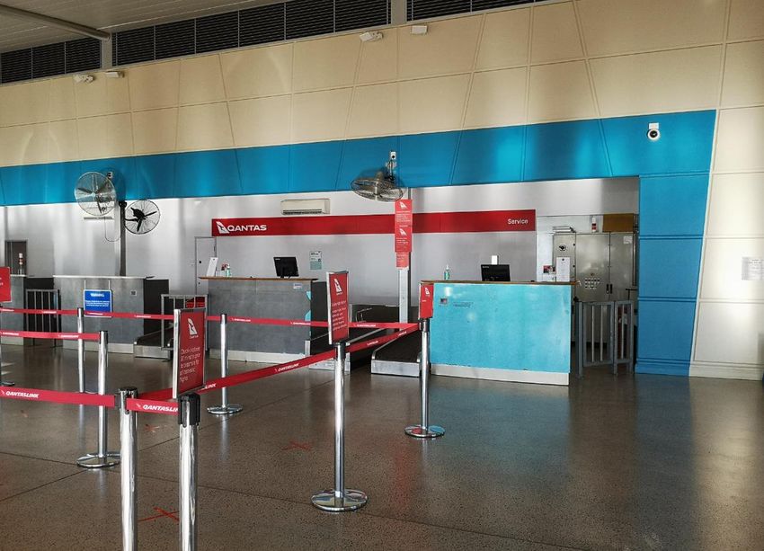
Figure 4    Wind Rose 9AM ............................................................................................................ 10
  Figure 5    Wind Rose 3 PM ........................................................................................................... 10
  Figure 6    Learmonth Airport Layout .............................................................................................. 18
  Figure 6    Passengers per annum forecast growth (indicative only) ................................................ 23
  Figure 7    Airservices Australia Satellite Ground Station ................................................................ 24
  Figure 8    Existing Qantas check-in counters ................................................................................. 31
  Figure 9    Current arrivals area with hire car operator desks .......................................................... 32
  Figure 10   Existing arrivals bus loop ............................................................................................... 33

Appendices
  Appendix A - Civil Site Lease Plan
  Appendix B – Learmonth Airport Development Plan
  Appendix C – Exmouth South Structure Plan

                                               GHD | Report for Shire of Exmouth - Learmonth Airport Master Plan, 12525231 | ii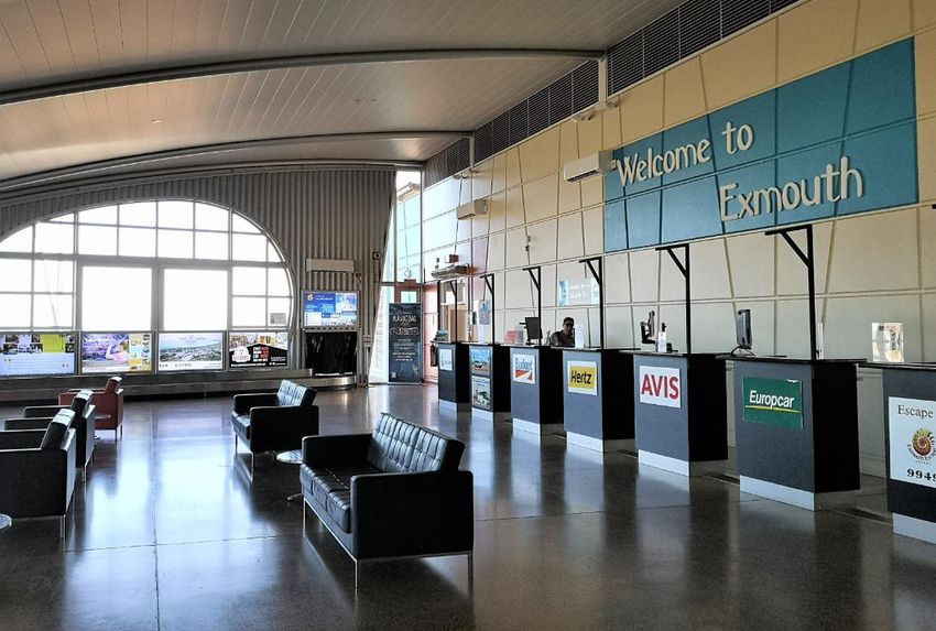
Abbreviations
     Abbreviation   Description                                    Abbreviation      Description

     ⁰C             Degrees Celsius                                B767              Boeing 767

     A300           Airbus A300                                    B777              Boeing 777

     A320           Airbus A320                                    BoM               Bureau of Meteorology

     A330           Airbus A330                                    C130              Lockheed C-130 Hercules

                    Australian Airports                            CAA               Civil Aviation Act
     AAA
                    Association
                                                                   CAF               Compressed Air Foam
                    Asymmetric Digital
     ADSL                                                          CARs              Civil Aviation Regulations
                    Subscriber Line

                    Aerodrome Frequency                                              Civil Aviation Safety
     AFRU                                                          CASA
                    Response Unit                                                    Authority

     AHD            Australian Height Datum                                          Civil Aviation Safety
                                                                   CASR
                                                                                     Regulations
                    Aeronautical Information
     AIP                                                           CBR               California Bearing Ration
                    Package

                    Australian Noise Exposure                      CHC               CHC Group LLC
     ANEF
                    Forecast
                                                                   COVID-19          Coronavirus Disease 2019
     AP3            AP-3C Orion
                                                                                     Common Traffic Advisory
                                                                   CTAF
     ARFF           Airport Rescue Firefighting                                      Frequency

                    Airport Rescue and Fire                                          Distance Measuring
     ARFFS                                                         DME
                    Fighting Services                                                Equipment

     AsA            Airservices Australia                                            Distance Measuring
                                                                   DME – I
                                                                                     Equipment International
     ATC            Air Traffic Control
                                                                   DoD               Department of Defence
                    Aviation Transport Security
     ATSA                                                          DoT               Department of Transport
                    Act

                    Aviation Transport Security                                      Eurocopter EC225 Super
     ATSR                                                          EC225
                    Regulations                                                      Puma

     AVGAS          Aviation Gasoline                                                En Route Supplement
                                                                   ERSA
                                                                                     Australia
     AW138          AgustaWestland AW138
                                                                   F100              Fokker 100
     AW139          AgustaWestland AW139
                                                                                     The Royal Flying Doctor
                                                                   FDS
     B737           Boeing 737                                                       Service

     B747           Boeing 747                                     FL                Flight Levels

                                   GHD | Report for Shire of Exmouth - Learmonth Airport Master Plan, 12525231 | iii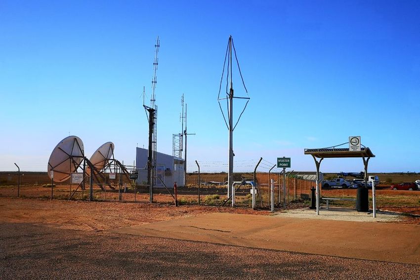
Abbreviation   Description                                     Abbreviation      Description

               Floating Production                             PA                Per Annum
FPSO
               Storage & Offloading
                                                                                 Procedures for Air
GA             General Aviation                                PANS-OPS          Navigational Services –
                                                                                 Aircraft Operations
GHD            GHD Pty Ltd
                                                                                 Precision Approach
ha             Hectares                                        PAPI
                                                                                 Indicator Lights

               High Intensity Runway                           Part 139          Part 139 (Aerodromes)
HIRL
               Light                                           MOS               Manual of Standards
               Her Majesty’s Australian                        PC9               Pilatus PC-9
HMAS
               Ship
                                                                                 Pavement Classification
               International Civil Aviation                    PCN
ICAO                                                                             Number
               Organization
                                                               PN                Prior Notice Required
km             Kilometre
                                                               psi               Pound per Square Inch
km/h           Kilometre per hour
                                                               RAAF              Royal Australian Air Force
L              Litre
                                                                                 Royal Flying Doctor
LGT            Light/Lighting                                  RFDS
                                                                                 Service
LPS            Special Control Area                            RPT               Regular Public Transport
m              Metre                                           RWY               Runway
               Metre Australian Height                                           Strategic Airport Assets
mAHD
               Datum                                           SAAFMF            and Financial Management
                                                                                 Framework
mm             Millimetre
                                                               SCA               Security Controlled Airport
MOS            Manual of Standards
                                                               SGS               Satellite Ground Station
MTOW           Maximum Take-Off Weight
                                                               Shire             Shire of Exmouth
               National Airports
NASF
               Safeguarding Framework                                            Strength Weakness
                                                               SWOT              Opportunity Threat
               National Broadband
NBN                                                                              Analysis
               Network
                                                               TSP               Transport Security Plan
NDB            Non Directional Beacon
                                                               USA               United States of America
O&G            Oil and Gas
                                                               VHF               Very High Frequency
               Obstacle Limitation
OLS
               Surfaces                                        VOR               VHF Omni Range
               Office of Transport                             WA                Western Australia
OTS
               Security

                                GHD | Report for Shire of Exmouth - Learmonth Airport Master Plan, 12525231 | ii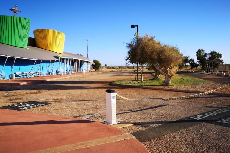
Abbreviation   Description                                   Abbreviation      Description

               Western Australia Planning                    WWII              World War 2
WAPC
               Commission

                             GHD | Report for Shire of Exmouth - Learmonth Airport Master Plan, 12525231 | iii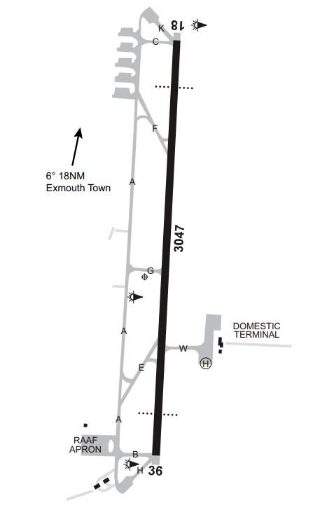
Learmonth Airport Master Plan

1.        Introduction
          1.1      Overview of the Airport
          An airfield was established at Learmonth in the 1940’s during WWII as part of military operation
          POTSHOT. In the 1950’s it was redeveloped as a RAAF base to provide fighter defence for the
          Australian and USA troops based on the North West Cape. Learmonth Airport is named in
          honour of Wing Commander Charles Cuthbertson Learmonth, a decorated WWII RAAF pilot
          awarded a Distinguished Flying Cross (and bar) whilst leading the 22 Squadron RAAF during its
          attack on a Japanese destroyer in the Battle of the Bismarck Sea in March 1943. He also flew in
          the air search for HMAS Sydney, fought in the New Guinea air war and trained many other
          WWII RAAF pilots.
          Wing Commander Learmonth died whilst commanding a 14 Squadron RAAF Beaufort Bomber
          during a training flight between Pearce and Rottnest Island on 6th January 1944. His account
          of the problems he encountered immediately prior to his fateful crash provided the answer as to
          why as many as 93 Beaufort Bombers had suffered similar crashes and fatalities prior, and it is
          for this that RAAF Learmonth base and Learmonth Airport is named in his honour.
          The Shire of Exmouth operates the civil airport located within the RAAF Learmonth base.
          Learmonth Airport is situated on Commonwealth land and owned by the RAAF under the
          Department of Defence. The Shire leases Learmonth Airport from the Department of Defence
          under a Deed of Operation. The Learmonth Airport lease area covers 23.9 hectares (ha) and is
          a Security Controlled Airport (SCA) with a Classification 3 under the Federal Aviation Transport
          Safety Security Act 2004.
          The airport is situated approximately 36km South of Exmouth and 120km North of Coral Bay
          and services Qantas passenger aircraft as well as helicopter operators supporting off-shore oil
          and gas operations.
          The terminal, which opened on 3 December 1999, has won a number of Royal Australian
          Institute of Architects awards for its innovative design which represents a coral reef.1

     1
         https://www.exmouth.wa.gov.au/aviation-services/learmonth-airport/about-learmonth-airport.aspx

                                        GHD | Report for Shire of Exmouth - Learmonth Airport Master Plan, 12525231 | 1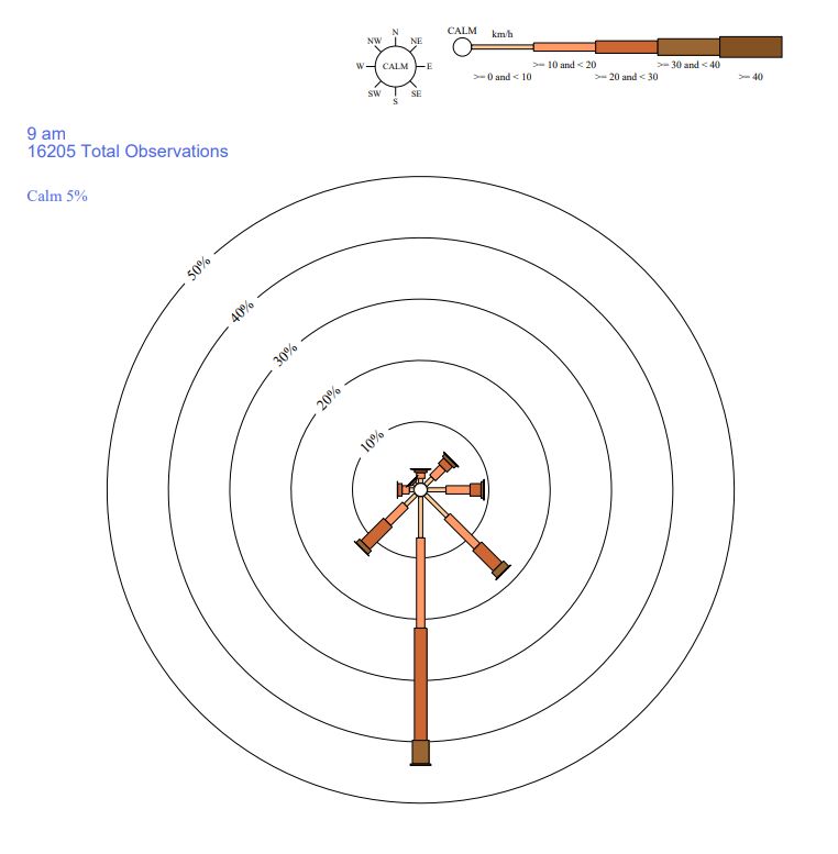
Learmonth Airport Master Plan
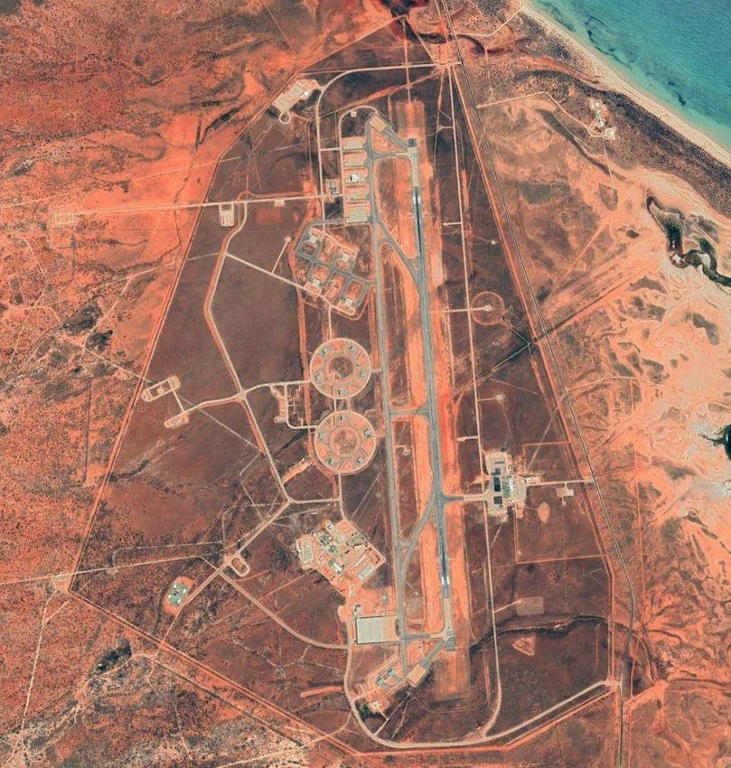
Figure 1 Aerial Image of Learmonth Airport2
1.2 Purpose and Objectives of the Master Plan
This Master Plan has been prepared for a planning period from 2020 to 2040.
Whilst these is currently no formal, legislated requirement for a local Government run airport to
produce a master plan, the Department of Transport advises that a master plan can form the
basis for Regional Airport Development Scheme funding applications.
This Master Plan, consequent to its focus on the Civil Airport Site, seeks to provide;
Airside planning statements for the expansion of taxiway and apron areas for envisaged
future needs; and,
Landside planning statements for expansion of terminal building, hangar sites and related
activity areas.
Specific criteria established by the Shire of Exmouth to be addressed by this Master Plan are;
An assessment of the contemporary passenger composition and the possible and
significant changes to the overall composition on the Regular Public Transport (RPT)
2
Google Earth 2020
GHD | Report for Shire of Exmouth - Learmonth Airport Master Plan, 12525231 | 2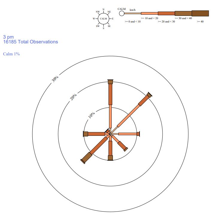
Learmonth Airport Master Plan
services on the Exmouth to Perth and Exmouth to Broome routes over the next 10 years
(Note: Exmouth to Broome services ceased in February 2013)
Development site availability for a substantial regional (RPT) operator, with regard to
hangar, maintenance and passenger lounge facilities, who may wish to establish and
provide feeder services to and from Learmonth Airport to outlying areas
Master Plan assessment and reviewing with stakeholder consultation
1.3 Methodology and Consultation
GHD undertook the following approach in completing the Master Plan for the Shire of Exmouth.
Desktop Update and Revise &
Project Review & Objectives Reformat Finalise
Initiation Data Assesment Master Master
Collection Plan Plan
Figure 2 Master Plan Methodology
A breakdown of tasks undertook in each stage are as follows:
Project Initiation
Start-up meeting with Shire of Exmouth
Confirm project delivery program and site visit
Confirm key stakeholders with Shire of Exmouth
Desktop Review & Data Collection
Reviewing existing data and statistics in the 2010 Master Plan (most recently updated in
2014) and updating to suit current status. Forecast passenger growth shall be based on the
current Master Plan rates in Figure 4.7, with amendments in line with any specific
passenger figure growth from stakeholders.
Conduct a desktop review of planning policy of the region
Conduct site visit and gather on-site information
Communicate with key stakeholders via email survey to identify their facilities, usage, and
forecast objectives
Collate stakeholder feedback and present to the Shire for discussion and agreement. RAAF
related requirements shall be communicated to GHD by the Shire
Objectives Assessment
Assessment of airside planning objectives, and updating to suit Shire plans and
expectations
Assessment of landside development planning objectives, and updating to suit Shire plans
and expectations
GHD | Report for Shire of Exmouth - Learmonth Airport Master Plan, 12525231 | 3Learmonth Airport Master Plan
Update and Reformat Master Plan
Update of airport development plans as required
Reformat the Master Plan to more closely align with the Australian Airports Association
(AAA) guidelines for regional airport master plans, and to form part of the Department of
Transport Strategic Airport Assets and Financial Management Framework (DoT SAAFMF)
Revise & Finalise Master Plan
Submit a draft Master Plan to Shire of Exmouth for review
Shire review of draft Master Plan
Revise Master Plan to incorporate Shire comments
1.4 Report Structure
This Master Plan follows a similar format to that recommended in the AAA’s Regional Airport
Master Planning Guideline, Airport Practice Note 4, with main section headings as follows:
Section 1 – Introduction
Section 2 – Strategic Vision and Objectives
Section 3 – Background Information
o Master Plan Context
o Current Situation
o SWOT Analysis
Section 4 - Critical Airport Planning Parameters
Section 5 – Airport Master Plan
o Movement Area Facilities Plan
o Land Use Plan
o Airport Safeguarding Plan
o Implementation Plan
1.5 Supplied Documents
Table 1 lists reference documents provided by the Shire of Exmouth.
Table 1 Supplied Documents
Document Author
Learmonth Masterplan Forte Airport Management
Learmonth Airport Scheduled Flight Movements Shire of Exmouth
Learmonth_Civil Lease Area-Master Plan (sheet 1 of 4) Shire of Exmouth
Learmonth Stakeholders Shire of Exmouth
Graphical RPT for Monthly Reports (DRAFT UPDATE) Shire of Exmouth
Aviation Services Strategic Plan Shire of Exmouth
GHD | Report for Shire of Exmouth - Learmonth Airport Master Plan, 12525231 | 4Learmonth Airport Master Plan
1.6 Scope and Limitations
This report: has been prepared by GHD for Shire of Exmouth and may only be used and relied
on by Shire of Exmouth for the purpose agreed between GHD and the Shire of Exmouth as set
out in section 1.2 of this report.
GHD otherwise disclaims responsibility to any person other than Shire of Exmouth arising in
connection with this report. GHD also excludes implied warranties and conditions, to the extent
legally permissible.
The services undertaken by GHD in connection with preparing this report were limited to those
specifically detailed in the report and are subject to the scope limitations set out in the report.
The opinions, conclusions and any recommendations in this report are based on conditions
encountered and information reviewed at the date of preparation of the report. GHD has no
responsibility or obligation to update this report to account for events or changes occurring
subsequent to the date that the report was prepared.
The opinions, conclusions and any recommendations in this report are based on assumptions
made by GHD described in this report. GHD disclaims liability arising from any of the
assumptions being incorrect.
GHD has prepared this report on the basis of information provided by Shire of Exmouth and
others who provided information to GHD (including Government authorities), which GHD has
not independently verified or checked beyond the agreed scope of work. GHD does not accept
liability in connection with such unverified information, including errors and omissions in the
report which were caused by errors or omissions in that information.
GHD | Report for Shire of Exmouth - Learmonth Airport Master Plan, 12525231 | 52. Strategic Vision and Objectives
2.1.1 Strategic Vision
The Shire of Exmouth will create a transport network that gets people to where they want to go
and experience the wonders of the Ningaloo area utilising national networks and a strong but
developing local aviation industry.
2.1.2 Objectives
The strategic objectives that have been identified for Learmonth Airport by Shire of Exmouth are
categorised into Airside and Landside objectives as summarised below.
Airside Objectives
The Shire of Exmouth have expressed the following planning objectives for this Master Plan and
stated the Learmonth Airport Master Plan is to provide directional guidance to development to
ensure expansion occurs without compromise of primary aviation and non-aviation objectives as
follows;
Provision of additional apron area for future aviation growth.
Provision of hangar sites for future aviation operations.
Provision of sealed surfaces for surface access between aprons, hangars and terminals.
Provision of additional flood lighting for new hangars and aprons.
Provision of an extension to the existing lease area to the south to accommodate future
building area and apron expansions
Provision for permanent Airport Rescue and Fire Fighting Services (ARFFS).
Provision for future Air Traffic Control (ATC).
Provision for airside operating elements to include the taxiway system and civil apron
areas.
Provision for increased fuel storage and truck parking facilities.
Provision for car park expansion.
Provision of solar generation power supply.
These are further detailed in Section 4.1 with relevance to current operational requirements.
Landside Objectives
The Shire of Exmouth have expressed the following planning objectives for landside
development planning for the Learmonth Airport.
Car park expansion with the possibility of a secure parking compound.
Refuelling depot relocation, including new storage and dispersing facilities for Jet A1 and
Avgas.
Provision for a freight office and possible cold storage facility.
An airport maintenance shed.
Terminal building expansion of existing airport terminal, including additional office spacing.
Improvements to disability access to terminal.Learmonth Airport Master Plan
Land areas assigned for any future development and provision for commercial expansion to
attract aviation businesses to the airport.
These are further detailed in Section 4.2 with relevance to current operational requirements.
In addition, the Department of Defence have indicated during lease negotiations that the Shire
of Exmouth should work towards self-sustainability of utilities. As such, the following is also
considered.
Consideration of independent power and water supply.
2.1.3 Development Approval and Restrictions
It is noted that any development airside or landside at Learmonth Airport requires review and
approval by the Department of Defence and Airservices Australia prior to commencement of the
development. Processes are in place to ensure relevant approvals are sought and
consideration of such matters as safety, security, services, navigational aid protection,
stormwater management, landscaping, communications, lighting and environmental controls are
considered.
It is also acknowledged that Learmonth Airport and the surrounding areas are affected by
building and structure height limits under the Defence [Areas Control] Regulations 1989. These
regulations are applied by the Department of Defence when determining applications for
buildings and structures in the area.
Lighting of buildings and structures within the vicinity of Learmonth Airport is informed by
Section 9.21 of the Manual of Standards Part 139 with the intention of minimising the potential
hazard to aircraft operations from the lighting. The requirements of ground lighting emission
intensity limits will be advised to any party proposing to install a lighting system within the
vicinity of Learmonth Airport and forms part of the Development Approval process.
GHD | Report for Shire of Exmouth - Learmonth Airport Master Plan, 12525231 | 7Learmonth Airport Master Plan
3. Background Information
3.1 Master Plan Context
3.1.1 Historical Background
Learmonth Airport, located at Exmouth Gulf, Western Australia, was first established in 1943 as
an operational air base during World War II. The war time buildings which were of a temporary
nature have long since ceased to exist. Since World War II the Airport has been jointly used by
civil and RAAF aircraft.
It is named after Wing Commander Charles Cuthbertson Learmonth, a WW II pilot, who died a
hero near Rottnest Island in January 1944 after remaining in his bomber radioing events until it
hit the water. This act of courage helped explain the cause of several earlier accidents.
The original Civil Terminal was a simple waiting shelter with toilets constructed for the comfort of
transfer of employees of the Harold E Holt Naval Base.
In 1969 the Commonwealth approved an upgrade of Learmonth Airport which at the time
comprised a runway of length 2,134 metres. The development provided for a runway extension
out to current overall runway of 3,047 metres. In 1974 additional upgrade of facilities occurred to
support operational and exercise deployments for the RAAF as a ‘Bare Base’.
In 1971 Learmonth Airport was gazetted as a first point of entry airport by the Commonwealth
enabling international flights on a restricted basis.
In 1982 a civil terminal with associated apron area was constructed. This building is presently in
use as a heliport enabling offshore helicopter passenger transfers.
After the 1992 transfer of the Navy Communications Station Harold E Holt from the United
States Navy to the Royal Australian Navy the American Government sold the majority of their
residential property that had been constructed in Exmouth and donated $10 million dollars from
the proceeds of these sales to the Exmouth Development Trust Fund, a part of which were
committed to the upgrading the Learmonth Airport Terminal.
In March 1993 the Commonwealth leased the civil facilities area of the Learmonth Airport to the
Shire of Exmouth for a term of 30 years.
In 1999 a new airport terminal with common user (domestic and international) capability was
constructed at a cost of $6.4M together with a northern extension of the aircraft apron area with
roadway interface for airside vehicle access.
In 2012 an expansion of the apron was undertaken to provide dedicated helicopter and GA
aprons.
3.1.2 Regional Climate
The region has a hot, semiarid climate with summer temperatures often exceeding 40oC. Rain is
most likely to fall between January and July with monsoonal showers from January to April. The
period from August to December is generally dry.
RAAF Base Learmonth is situated in a highly cyclone-prone area. In March 1999, tropical
cyclone Vance moved down the Exmouth Gulf causing winds recorded to 267 km/h, the highest
ever wind gust measured on the Australian mainland.
Climate data has been obtained from the Bureau of Meteorology website for weather station
number 005007, Learmonth Airport. Statistical information has been recorded at RAAF Base
Learmonth since 1945.
GHD | Report for Shire of Exmouth - Learmonth Airport Master Plan, 12525231 | 8Learmonth Airport Master Plan
Table 2 Climatic Data
Item Annual
Mean max. 31.9
temperature degrees
centigrade
Mean min. 17.7
temperature degrees
centigrade
Mean 259 mm
rainfall
The annual mean rainfall is presented in Figure 3. The data was obtained from the Bureau of
Meteorology website for the Learmonth Airport Station (station 005007). The mean rainfall data
ranged from 1945 to 2020.
Figure 3 Learmonth Mean Rainfall
The prevailing winds at the Learmonth Base are predominantly from the south. A copy of the
wind roses from the Bureau of Meteorology website are provided in Figure 4 and Figure 5. The
wind roses are based on data from 1975 to 2020.
GHD | Report for Shire of Exmouth - Learmonth Airport Master Plan, 12525231 | 9Learmonth Airport Master Plan
Figure 4 Wind Rose 9AM
Figure 5 Wind Rose 3 PM
GHD | Report for Shire of Exmouth - Learmonth Airport Master Plan, 12525231 | 10Learmonth Airport Master Plan
3.1.3 Regional Context
The name Exmouth is taken from the Exmouth Gulf which was named by Captain Phillip P. King
when surveying the northern coastline on the 18th February 1818.
Named after Edward Pellew, First Viscount Exmouth (1758 -1833) who distinguished himself in
the British Royal Navy from 1776, (Battle of Lake Champlain), until 1816 (bombardment of
Algiers).
Many of the streets in Exmouth are named in honour of Australian and British servicemen who
took part in World War II. Streets are also named after early residents and navy or military
operations or craft. This gesture recognises the importance of naval/military history to the
region.
Exmouth is located 1,270 kilometres north of Perth and it can be accessed within 12.5 hours by
motor vehicle and approximately 16 hours by bus. Aircraft travel between Perth and Exmouth
takes approximately 1 ¾ hours on a jet service.
Exmouth is a service centre for the Exmouth/Coral Bay region. It is surrounded by rural stations
and has a number of other diverse industries drawn into the airport’s catchment such as
tourism, fishing, oil and gas industry and government agency business.
Learmonth Airport is approximately 35 km south of Exmouth and it supports General Aviation
(GA) (inclusive of helicopter operations) and Regular Public Transport (RPT) civil aircraft
operations. It is the main regional base for aircraft charter operators with the Ningaloo Marine
Park and Whale Shark as the major international tourism attractions.
Significant Airports within proximity to Learmonth are Carnarvon 360 kilometres to the south,
Karratha 600 kilometres and Broome 1,100 kilometres to the north.
3.1.4 Regional Economy
Exmouth and Learmonth Airport are strategically located at the northern end of the Northwest
Cape.
The Northwest Cape covers a huge area with the Ningaloo Reef on its western side stretching
260 km from slightly north of Exmouth to Amherst Point, south of Coral Bay. The Exmouth Gulf
forms its eastern boundary.
The town of Exmouth was originally established in 1964 as a support town for the
communications base located at the North West Cape. While the base is still operating the town
has established itself as the gateway to the Ningaloo Reef making it a top tourism destination to
the extent that tourism is now the major industry contributor to the local economy.
The economy of Exmouth is also supported by oil & gas exploration/production, fishing,
aquaculture and pastoral activity.
The Shire of Exmouth is situated within the Gascoyne Region, which is one of nine geographic
regions within Western Australia.
The Gascoyne Region comprises the local government municipalities of Exmouth, Carnarvon,
Shark Bay and Upper Gascoyne.
The Gascoyne in the north-west of Western Australia is a Region rich in resource and
investment potential. It stretches along 600 km of Indian Ocean Coast, and inland 300 km
through dramatic desert country beyond Mount Augustus.
It enjoys a moderate and tropical climate with 320 days of sunshine per year, and a wealth of
attractions for the visitor including the Ningaloo Reef, Cape Range National Park and the
outstanding natural values of the Shark Bay World Heritage Property.
GHD | Report for Shire of Exmouth - Learmonth Airport Master Plan, 12525231 | 11Learmonth Airport Master Plan
The catchment area for Learmonth Airport is not just the Shire of Exmouth but also the upper
section of the Gascoyne region including Coral Bay and east to include several pastoral stations
and mining companies. The Shire of Exmouth has a population of around 2,800 but this
increases to around 6,000 during the tourism season of April to October. Each year Exmouth
welcomes over 100,000 visitors with an average length of stay of over seven nights. The
Gascoyne Region has strong tourism appeal, sound record of environmental management,
relatively good water resources and a broad economic base.
The Gascoyne Regional Development Plan provided a vision for the future growth of the region
for the next ten years from 2010 to 2020.
Among its key priorities is growth of the population across the Gascoyne Region together with
continued expansion of the tourism industry and improved air services both within and to the
Region.
Significant public and private expenditure within the Gascoyne Region is envisaged over the
period of this Master Plan focussing on community development, tourism, maritime, land
development, health and water supplies.
All of these projects and a growing population will lead to greater utilisation of the air services.
3.1.5 Regulatory Context
CASA's primary function is to conduct the safety regulation of civil air operations in Australia
and the operation of Australian aircraft overseas. It is also required to provide comprehensive
safety education and training programmes, cooperate with the Australian Transport Safety
Bureau, and administer certain features of Part IV of the Civil Aviation (Carriers' Liability) Act
(CAA) 1959.
The Civil Aviation Regulations (CARs) 1988 and the Civil Aviation Safety Regulations (CASR)
1998, made under authority of the Civil Aviation Act (CAA) 1988, provide for general regulatory
controls for the safety of air navigation. The CAA, CARs and CASR empower CASA to issue
Civil Aviation Orders on detailed matters of regulation and to issue Manuals of Standards (MOS
) which support the CASR by providing detailed technical material. Other relevant regulations
include:
Air Navigation Act 1920;
Commonwealth Authorities and Companies Act 1997;
Auditor-General Act 1997;
Ombudsman Act 1976;
Freedom of Information Act 1982;
Privacy Act 1988;
Administrative Appeals Tribunal Act 1975; and
Administrative Decisions (Judicial Review) Act 1977.
The relevant regulations in Australia are the Civil Aviation Regulations 1988 (CARs), which are
gradually being replaced by the Civil Aviation Safety Regulations 1998 (CASRs). CASR Part
139 prescribes the requirements for aerodromes used in air transport operations, in accordance
with ICAO Annex 14 - Aerodromes. The Part 139 (Aerodromes) Manual of Standards (Part 139
MOS) is made pursuant to CASR Part 139. The Part 139 MOS sets out the detailed standards
and operating procedures for aerodromes used in air transport operations in Australia.
It is also acknowledged that Learmonth Airport and the surrounding areas are affected by
building and structure height limits under the Defence Areas Control Regulations 1989. These
GHD | Report for Shire of Exmouth - Learmonth Airport Master Plan, 12525231 | 12Learmonth Airport Master Plan
regulations are applied by the Department of Defence when determining applications for
buildings and structures in the area.
3.1.6 Policy Context
Under Part 3 of the Planning and Development Act 2005, State Planning Policies provide the
highest level of planning policy control and guidance in Western Australia.
Different levels of local and federal have established policies to assist in the planning and
safeguarding of the aviation industry. These policies are discussed in the following.
The Federation Aviation Policy provides Aviation aims and principles for the Australian industry.
Relevant principals extracted from this policy being utilised in this Master Plan are:
Recognise the importance of Australian airports to the economy
Ensure that aviation security measures are risk based
Reduction of noise at the source
Noise abatement operational procedures
The Federal Aviation Policy White Paper 2009 is a long term policy and planning document that
outlines the following objectives in planning an airport:
Give aviation industry the certainty and incentive to plan and invest for the long term
Maintain and improve Australia’s excellent aviation safety record
Give proper consideration to the interests of travellers and users of airports
Better manage the effect of aviation activities on communities and the environment.
The State Government Policy and Regulation noted that the WA Government will continue to
lightly regulate the Exmouth-Perth route (allowing multiple operators on the route) and monitor
performance by requiring airlines operating RPT air services to:
Report statistics and records to DoT
Engage with stakeholders and communities to an adequate level
The Shire of Exmouth will implement the Local Planning Strategy through the new LPS 4
The Exmouth Learmonth (North West Cape) Structure Plan 1998 provides a planning
framework for the whole of the North West Cape. A main objective of the plan is to locate on
Commonwealth land adjoining the townsite activities that complement the Exmouth Townsite
and do not conflict with defence activities (non-defence activities are not acceptable on the
naval communications station). The Plan did promote the relocation of the wastewater treatment
plant from within the townsite boundary onto Commonwealth land.
3.1.7 Previous and Current Master Plans
A Master Plan (Forte Airport Management 2014) has been adopted for the Learmonth RAAF
Base which covers the Shire’s civil lease area. The Master Plan identifies the proposed
development within the 23.8 ha lease area, including a future lease expansion of 5.15 ha to the
south of the existing lease boundary. The Master Plan documents proposed development
including future apron development, hangars, long term car park, public car cark and airport
storage north of existing buildings. Proposed development including an expansion to the
helicopter apron reserve, hangar reserve, new road and airport storage is proposed south of the
existing buildings.
GHD | Report for Shire of Exmouth - Learmonth Airport Master Plan, 12525231 | 13Learmonth Airport Master Plan
3.1.8 Key Stakeholders
The following list of key stakeholders, provided by the Shire, were approached by GHD to
inform this Master Plan.
Shire of Exmouth
Emergency services
Airlines
Charter services
Helicopter operators
GA operators
Hire car companies
Freight companies
Local business owners
3.2 Current Situation
3.2.1 Ownership and Management
The Aviation Services department of the Shire of Exmouth oversees the management and
operation of the airport.
The Shire of Exmouth has a lease with the Department of Defence for the civil lease area3 until
7 March 2033. The lease, and associated Operating Deed, provides Council officers with
delegated authority to approve a number of aircraft movement approval functions on behalf of
Defence. Other more long-term operations require formal Defence approval which is provided
on behalf of the operator to Defence. The Operating Deed also outlines the number of
movements that can occur in the three operational status levels: Dormant, Military-in Use and
Activated. The Department of Defence provides consent to all sub-leases and development
within the civil lease area prior to execution/commencement.
There are three (3) areas of RAAF Learmonth being:
The Military Area used as a RAAF base by Department of Defence (DoD);
The Licenced Area which includes Runway 18/36 and Taxiway Whiskey and has common
usage by the DoD, the Shire of Exmouth and others; and
The Civil Airport Site, which is the lease area under management control of the Shire of
Exmouth for the purposes of operating a civil aviation terminal and other aviation-related
functions.
An Operating Deed forms an attachment to the Learmonth Airport Deed of Variation relating to
the operations of civil aircraft and the use, access and management of the Licensed Area at
Learmonth Airport. It maybe varied from time to time through a consultative process and the
current Operating Deed must always be referenced.
Subject to the Lease and the Operating Deed the Shire of Exmouth has an obligation to:
Comply with relevant legislation as if it were the operator of a certified Airport under the
Civil Aviation Safety Regulations 1998; and
3
Appendix A – Civil Site Lease Plan
GHD | Report for Shire of Exmouth - Learmonth Airport Master Plan, 12525231 | 14Learmonth Airport Master Plan
Comply with any conditions specified by the Civil Aviation Safety Authority pursuant to
section 20 of the Civil Aviation Act 1988; and
Impose similar obligations upon any sub-lease to comply with relevant legislation and
conditions applied under the above.
In addition, under clause 14.3 of the Operating Deed the Shire of Exmouth are required to
submit a Master Plan for the proposed development of the Civil Airport Site for approval by DoD
whom must approve or reject the Master Plan in writing.
Under the terms of the lease the Master Plan may be amended at any time and it must have
regard to:
The actual and anticipated growth in, and pattern of, traffic demand for the Civil Airport Site;
The quality standards reasonably expected of such an airport in Australia; and
Good business practice as defined in sub-clause 1.1 of the Learmonth Airport Deed of
Variation.
The Shire of Exmouth must ensure all development (clauses 14.8 to 14.19 of the Operating
Deed apply) on the Civil Airport Site:
Is carried out in accordance with the Master Plan as approved by DoD from time to time;
Complies with all relevant legislation and all requirements of any relevant Government
Authority; and
Is carried out in a proper and workmanlike manner.
3.2.2 Site Description
Learmonth Airport is located off Minilya-Exmouth Road on a 23.8 ha leased portion of the
defence base RAAF Learmonth. Within the Civil Airport Site lease, the Shire of Exmouth has
two terminals (RPT and Heliport), three sheds, aprons (RPT, Helicopter and GA) and taxiway.
A number of sub-leases are also in place, being the fuel storage facility (World Fuel Services),
shed (Exmouth Aviation Services), navigational aid infrastructure (Airservices Australia), freight
offices (Exmouth Freight Services and Colta Pty Ltd) as well as a number of subleases within
the terminal building.
Learmonth Airport is approximately 35 kilometres south of the Exmouth township and services
the Shire of Exmouth and the Upper Gascoyne region generally.
RAAF Base Learmonth is situated within a coastal plain and is generally flat. Elevations range
between 0 and 20 m AHD. The land rises further west towards the coastal ranges to a height of
220 mAHD. The coastline east of RAAF Base Learmonth is comprised of sand dunes, which
rise up to 9 mAHD. Between RAAF Base Learmonth and the dunes is a low lying area occupied
by Wapet Creek and a wider salt pan area. This area displays signs of evaporation and
formation of salt crusts. Salt-resistant plants including succulents and mangroves grow in this
area. Wapet Creek discharges through a gap in the dunes to Exmouth Gulf
3.2.3 Security Requirements
The Office of Transport Security (OTS), a section of the Commonwealth’s Department of
Infrastructure and Regional Development, is responsible for ensuring that regulatory compliance
to the Aviation Transport Security Act (ATSA) 2004 and Aviation Transport Security Regulations
(ATSR) 2005 and any supporting documentation is implemented at airports across Australia.
The ATSA and ATSR empower the Minister, Secretary and Transport Security Inspectors to
approve and enforce the requirements of the ATSA and ATSR at airports as well as with airlines
and other aviation industry partners.
GHD | Report for Shire of Exmouth - Learmonth Airport Master Plan, 12525231 | 15Learmonth Airport Master Plan
OTS has seven levels of classification for RPT airports depending on the level of screening to
be undertaken. Learmonth Airport is a Classification 3 airport which therefore requires security
screening, security zones and a transport security program and security context risk statement
for the airport. OTS Transport Security Inspectors annually audit the airports’ security
processes and procedures and regularly undertake systems audits of the screening point.
3.2.4 Surrounding Land
Surrounding the airport are pastoral lands, with the Exmouth town site to the North, a Solar
Observatory, Bureau of Meteorology and the Exmouth Gulf to the East. While the West of the
Airport is pastoral land, the southern land of the airport has various landfills and base supply
borefield.
The land surrounding Learmonth Airport is depicted in the Exmouth South Structure Plan
(October 2013), with a copy of Plan 9 – Structure Plan found in Appendix C.
According to the Local Planning Strategy for Shire of Exmouth, the indicative noise buffer for
Learmonth Airport is classified as a Special Control Area within LPS 4. Any development
proposed within the buffer zone is to be referred to the Department of Defence prior to
determination.
3.2.5 Existing Activities
Learmonth Airport receives daily return Regular Public Transport (RPT) air services from Perth
through Qantas. Qantas are the only public airline to service Learmonth Airport, since Virgin
Australia Regional Airlines ceased operations in October 2014. Qantas fly twice daily Perth to
Learmonth return services and a daily service on the weekends. Qantas most commonly
operate the Fokker F100.
Learmonth Airport has several GA charter operators that provide private flying, charter flying
and aerial work for clients at the airport. None of which have fixed base hangar facilities.
The regular GA operators include:
Norwest Airwork
Karratha Flying Services
Tropic Air
Skippers Aviation
Maroomba Air Services
Bristow Helicopters, who provide offshore passenger transport services to a consortium of
companies operating offshore from Exmouth, utilising 18 seat ‘Super Pumas’, 10 seat
‘Sikorski’, 12 seat AW139 and 18 seat EC225 helicopters.
CHC Helicopters, who provide occasional offshore passenger transport for Woodside
Energy Limited and Shell Exploration, utilising 16 and 12 seater AW138 and AW139
helicopters.
Network Aviation
The Royal Flying Doctor Service (RFDS)
Flying training squadrons from RAAF Base Pearce regularly operate from the RAAF Base
Learmonth. They fly the PC9 and Hawke training aircraft often staying on extended exercises
conducting circuits and cross-country navigation exercises. C130 Hercules and AP3 Orion
aircraft also use Learmonth Airport for training and staging operations on occasions throughout
the year.
GHD | Report for Shire of Exmouth - Learmonth Airport Master Plan, 12525231 | 16Learmonth Airport Master Plan
Learmonth Airport is currently classified as an alternate international airport with approval to be
a first point of entry. With the Quarantine Act 1908 being replaced by the Biosecurity Act 2015
from 16 June 2016, designation of first point of entry has now been removed from RAAF
Learmonth & Learmonth Airport and amended to temporary first point of entry to allow for ad-
hoc international services (such as those defence aircraft coming from Cocos (Keeling) Islands)
and alternate diversions. A number of international airline operators have received formal
Defence approval to use of Learmonth Airport as an alternate in the event of weather
requirements at Perth or onboard emergencies. As of March 2014, these airlines are Qantas,
Emirates, Cobham Regional, Cobham Special Mission, Malaysian, Air Asia, Air Austral, Air
Mauritius, Air New Zealand, Network, Qatar, Scoot, Singapore and Turkish Airlines.
The Oil and Gas industry (O&G) also utilise Learmonth Airport by moving their fly-in, fly-out
workers from the airline services to helicopters to fly them out to their Floating Production
Storage & Offloading (FPSO) facilities. There are currently three FPSO’s located in waters off-
shore the western side of Exmouth. Oil & Gas exploration is cyclic with decision regarding
exploration drilling programs being influenced by a number of factors such as the global price of
oil per barrel, current well (production) life and the world market. Production is the more stable
operation, with known numbers of workers over the lifespan of the well. Woodside Energy
Limited, BHP Billiton and Santos operate their FPSOs flying their staff out of Learmonth Airport
to access these FPSOs. In 2012-13 at the height of the resources boom, around 26% of RPT
passengers then travelled on helicopters off-shore, however in 2015-16, the average was down
to 17% due to the extremely low oil price.
Aircraft Landings
Civilian aircraft movement records are kept by the Shire of Exmouth for all civil aviation activity
at Learmonth Airport.
The table below lists recorded civil aircraft landings over the ten years, 2007/08 to 2016/17. It
includes RPT, charter, general aviation, and rotary movements.
Table 3 Total Landings by Financial Year
Financial Year Total Landings Qantas GA Rotary RFDS Other
2007/08 3,134 0 260 1,587 59 1,228
2008/09 3,126 0 241 1,920 67 898
2009/10 4,227 0 296 2,868 103 960
2010/11 3,773 41 168 2,647 70 847
2011/12 3,599 390 144 2,401 103 561
2012/13 3,748 629 197 2,142 106 674
2013/14 3,487 627 304 1,872 121 563
2014/15 2,598 623 225 1,402 118 230
2015/16 2,181 626 171 1,200 108 76
2016/17 2,023 638 143 1,066 118 58
2017/18 * * * * * *
2018/19 * * * * * *
Note * data not available to GHD at time of writing.
Regular Public Transport (RPT) Passengers
RPT passenger numbers have remained relatively steady across 2014/15 to 2018/19. This is in
line with the steady Oil and Gas industries, and local tourism. RPT passenger numbers in 2020
are expected to be severely impacted by the COVID-19 global pandemic. It can be reasonably
expected that passenger numbers will increase back to averages as per 2014/15 to 2018/19
post-COVID-19 restrictions in Australia and the world, allowing tourism to recommence.
GHD | Report for Shire of Exmouth - Learmonth Airport Master Plan, 12525231 | 17Learmonth Airport Master Plan
Table 4 RPT Passenger Number by Financial Year
Financial Year RPT Passenger Numbers
2007/08 44,674
2008/09 43,210
2009/10 71,622
2010/11 78,821
2011/12 87,600
2012/13 92,851
2013/14 91,741
2014/15 85,705
2015/16 85,990
2016/17 80,017
2017/18 87,084
2018/19 85,922
3.2.6 Existing Facilities
Airport Particulars
The published Learmonth Airport details of movement area, navigation aids, air traffic services,
ground services, public facilities available and special procedures are expressed in the
Aeronautical Information Package En Route Supplement Australia (AIP ERSA). The abridged
details are stated below:
Figure 6 Learmonth Airport Layout4
4
https://www.airservicesaustralia.com/aip/current/ersa/FAC_YPLM_27FEB2020.pdf
GHD | Report for Shire of Exmouth - Learmonth Airport Master Plan, 12525231 | 18Learmonth Airport Master Plan
Runway designation................................... 18/36
Runway bearing......................................... 183° Magnetic
Runway dimensions................................... 3,047 m x 45 m sealed (259 m at the northern
end, and 228 m at the southern end are
concrete, the remainder is flexible / asphalt)
Runway pavement strength....................... PCN 43/F/A/1750 (254 psi) / T
Taxiway & apron pavement strength......... PCN 43/F/A/1750 (254 psi) / T
Runway slope............................................ 0.06% down to N
Lighting...................................................... HIRL RWY 18/36
PAPI
LGT for Civil Ops Manually Activated on PN to
Reporting Agent
Navigational aids........................................ NDB S22°14.5’ E114°05.7’
VOR/DME S22° 14.1’ E114° 05.7’
TAC S22° 13.5’ E114° 05.5’
Control Zones............................................ CTAF – AFRU 118.3 (R)
Ground Services........................................ REPLEN World Fuel Services: Jet A1 H24
Civil Apron.................................................. Bays 1, 2 and 3 for RPT only. GA parking on 24
Prior Notice. H1, H2 & H3 for helicopters only
Apron and Taxiway Areas
The original civil apron was evaluated for pavement strength in 1995. The report identified the
pavement comprised 330 mm of crushed rock overlying a high strength gravel subgrade
exhibiting CBR soaked of 30%. Asphalt surfacing was 50 mm. This asphalt surface was
subsequently overlaid by a further 50 mm of asphalt in 1999.
A third RPT parking bay and a GA parking area was added to the north of the existing apron in
1999 comprising 400 mm of crushed rock pavement and 50 mm asphalt.
The development plan at the time was for GA parking to be provided at the southern end of the
apron but negotiations for the relocation or removal of a disused AVGAS tank failed. The GA
apron parking for fixed wing aircraft consequently was provided to the north of the RPT apron.
Taxiway Whiskey is the only civil link to the civil apron area. Both the apron and taxiway have
an assigned PCN 32/F/A/1750/U due to their similar construction, however a pavement
condition assessment in August 2003 recommended that the PCN be amended to PCN
43/F/A/1750/T. The Shire of Exmouth is responsible for the assessment and issue, as
appropriate, of occasional pavement concessions for civil aircraft operator access to apron
parking areas.
Expansion of the helicopter bays to provide 3 operational bays and the GA parking area was
completed in 2012.
Aviation Fuel
Hydrant refuelling points were removed during the apron upgrade and Mobil Oil positioned
tanker refuelling, which provided greater flexibility for refuelling the range of aircraft type
GHD | Report for Shire of Exmouth - Learmonth Airport Master Plan, 12525231 | 19Learmonth Airport Master Plan
operating. Jet A1 storage capacity is 190,000 litres in above ground, bunded tanks, managed
now by World Fuel Services.
Up until late 2009 AVGAS was stored and dispensed by tanker. However, low volume sales
resulted in the withdrawal of AVGAS product from Learmonth.
Terminal Building
The Civil Airport Site terminal building facilities are capable of handling simultaneous operations
of domestic and international aircraft. Termed ‘common user’ the terminal has partitions to
enable the separation of passengers for security and customs purposes.
The ‘breezeway’ (café) area was designed to accommodate up to 100 persons. The central
departures and northern arrivals zones were designed for the B767 as the design aircraft, each
with an area footprint of up to 150 persons. Entry to the central departure lounge is via
passenger security screening for the jet service.
Officially opened on 3 December 1999 by the Deputy State Premier the Honourable Hendy
Cowan, the terminal provides the travelling public with modern, comfortable facilities and the
Exmouth community with a strong tourism entry statement. Learmonth Airport is a gateway to
the Region facilitating transfer of persons arriving and departing by air.
The Shire of Exmouth embarked upon the terminal development project in recognition of the
huge tourism potential of the Region and the need to facilitate both domestic and international
visitor transfers.
Learmonth Airport is a Commonwealth declared Restricted International Airport, which enables
international charter flights to occur, subject to prior notification to enable facilitation by
Customs, Immigration and Quarantine agencies.
The Shire of Exmouth owns the check-in counters, baggage make up and arrival conveyors,
passenger security screening equipment and checked bag security screening equipment
associated with the airline transport operations within the terminal.
In 2010, the old terminal was used in part by the ground handling company for freight and
storage. In recent times Bristow Helicopters Pty Ltd have sub-leased and modified the building
to suit heliport passenger processing for offshore transfers. From January 2012, heliport
operations were transferred to the Shire of Exmouth.
Car Park
The car park has an approximate 120 bay capacity. All areas are public paid parking and no
secure parking areas exist. However, a number of these bays have been designated for
disabled, rental cars and airport management.
Set down and pick areas exist in front of the terminal, although limited in area.
Utilities
Electricity at the RAAF Base is reticulated from the Exmouth town supply. A metered electrical
distribution service exists from the RAAF Base to the Civil Airport Site. This supply is supported
by emergency power in the event of mains power failure via generators located on the RAAF
Base.
Water Supply to the Civil Airport Site is via the RAAF Base water bores. The supply has
booster pumps when required for high pressure delivery from hydrant outlets.
GHD | Report for Shire of Exmouth - Learmonth Airport Master Plan, 12525231 | 20Learmonth Airport Master Plan
Sewerage Services at the Civil Airport Site are by way of septic tanks located in the grass area
between the terminal and the apron. A new septic system was installed at the time of terminal
construction in 1999.
3.3 SWOT Analysis
Strengths and Advantages Weaknesses and Constraints
- There is adequate area landside to - Learmonth is serviced by a single RPT
expand parking, storage and other operator reducing the opportunity for
facilities. competition and negotiation.
- There are no restrictions or noise - Apron size currently does not support
abatement issues at the airport. multiple Code 4C aircraft operations.
- Proximity to Ningaloo Reef and - Adequate internet service to the
associated tourism airport is limited
- Communication between RAAF , - No hangars available for aviation
Shire of Exmouth, and Heliport operators to utilise
Operators
Opportunities and Prospects Threats and Risks
- Potential for intrastate WA flights to - COVID-19 impacts to tourism
operate to promote tourism.5
- Flooding of access road can close the
- Potential to support more Oil and Gas airport
operations if helicopter facilities are
expanded.
- Reconfiguration of passenger security
screening area in terminal expansion.
- Potential for freight facilities and
freight storage to be developed in the
future.
- Opportunity to construct additions to
RPT apron and a new taxiway in
conjunction with RAAF airside
upgrade works
5
Air Route Connectivity in Mid and North West of Western Australia Survey Data Analysis (2015)
GHD | Report for Shire of Exmouth - Learmonth Airport Master Plan, 12525231 | 21Learmonth Airport Master Plan
4. Critical Planning Parameters
4.1 Critical Airside Planning Parameters
4.1.1 Forecast of Future Operations
The COVID-19 global pandemic has had a significant impact on the aviation industry, including
all associated industries, such as tourism, mining, oil and gas. For example, the Woodside
Scarborough gas field investment decision has been delayed until 2021, and the Western
Australian borders are currently closed to non-essential travellers. This will cause a significant
reduction in aircraft movements and passenger movements through Learmonth Airport
throughout 2020. As such, growth of RPT passenger numbers at Learmonth Airport have been
forecast with the assumption that passenger numbers will return to pre-2019/20 quantity by end
of 2020/2021, and have been forecast with 5% and 10% per annum growth as per the 2014
Master Plan. As growth since the previous Master Plan has been ‘flat’ a lower growth rate of 2%
has been included for comparison.
Table 5 Passengers per annum forecast growth (indicative only)
Financial Year RPT 2% per annum 5% per annum 10% per
Passenger growth growth annum growth
Numbers
2018/19 85,922
2019/20 40,000*
2020/21 60,000*
2021/22 85,000* 85,000 85,000 85,000
2022/23 86,700 89,250 93,500
2023/24 88,434 93,713 102,850
2024/25 90,203 98,398 113,135
2025/26 92,007 103,318 124,449
2026/27 93,847 108,484 136,893
2027/28 95,724 113,908 150,583
2028/29 97,638 119,604 165,641
2029/30 99,591 125,584 182,205
2030/31 101,583 131,863 200,426
2031/32 103,615 138,456 220,468
2032/33 105,687 145,379 242,515
2033/34 107,801 152,648 266,766
2034/35 109,957 160,280 293,443
2035/36 112,156 168,294 322,787
2036/37 114,399 176,709 355,066
2037/38 116,687 185,544 390,573
2038/39 119,021 194,822 429,630
2039/40 121,401 204,563 472,593
Note * 2019/20 to 2021/22 RPT Passenger Numbers estimated based on assumed recovery
from COVID-19 pandemic.
No formal forecasting has been undertaken for this Master Plan and the above figures are for
comparison purposes only and are not to be used for business forecasting or any other
purpose.
GHD | Report for Shire of Exmouth - Learmonth Airport Master Plan, 12525231 | 22You can also read