DATE CONTACT BRIDGET WOUTS - 16 March, 2020 - Dubbo Airport
←
→
Page content transcription
If your browser does not render page correctly, please read the page content below
DATE
                                                                    CONTACT
                                                                                    16 March, 2020

                                             bridget.w@lar.net.au
                                                                    BRIDGET WOUTS

Dubbo City Regional Airport | Master Plan 2019 – 2040
For Dubbo Regional Council
TABLE OF CONTENTS
1.0 INTRODUCTION 1
2.0 PURPOSE 2
2.1 MASTER PLANNING APPROACH 3
3.0 DUBBO CITY REGIONAL AIRPORT 5
3.1 LOCATION 5
3.2 EXISTING AIRSIDE FACILITIES 5
3.3 EXISTING LAYOUT AND USERS 9
3.4 HISTORY OF THE AIRPORT 13
4.0 PLANNING CONTEXT 15
4.1 REGIONAL CONTEXT 15
4.2 LOCAL CONTEXT 17
4.3 LAND USE 20
4.4 AVATION REGULATORY CONTEXT 22
5.0 STAKEHOLDER CONSULTATION 24
5.1 ON-SITE MEETING 24
5.2 TELEPHONE DISCUSSIONS 24
5.3 EMERGING THEMES 24
6.0 AVIATION ACTIVITY FORECASTS 27
6.1 PASSENGER GROWTH AND PROJECTION 27
6.2 RPT AIRCRAFT TYPE GROWTH PROJECTION 28
6.3 GENERAL AVIATION GROWTH AND PROJECTION 30
7.0 STRATEGIC DIRECTION 33
7.1 VISION STATEMENT 33
7.2 PHILOSOPHY 33
7.3 GOALS AND OBJECTIVES 33
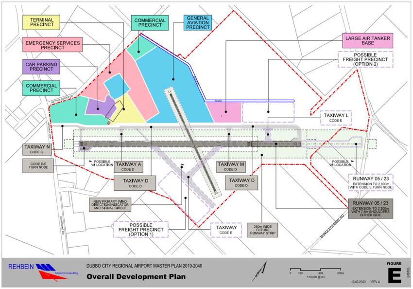
8.0 DEVELOPMENT CONCEPT 34
8.1 OVERALL DEVELOPMENT PLAN 34
8.2 AIRSIDE INFRASTRUCTURE 37
Ref: B19103AR001Rev4 - i - Dubbo City Regional Airport
Master Plan 2019 – 2040
8.3       AIRCRAFT PARKING AREAS                                                         41
8.4       CAR PARKING                                                                    43
8.5       ARO BASE                                                                       43
8.6       HELICOPTER PARKING STANDS                                                      43
8.7       WIND DIRECTION INDICATORS AND GROUND SIGNALS                                   43
8.8       FUEL STATIONS                                                                  44
8.9       INDICATIVE DEVELOPMENT STAGING, TRIGGERS AND TIMING                            44
8.10      LONG TERM MASTER PLANNING AND EFFECTIVE ASSET MANAGEMENT                       46
9.0       AIRPORT SAFEGUARDING                                                           48
9.1       THE NEED FOR SAFEGUARDING                                                      48
9.2       NATIONAL AIRPORTS SAFEGUARDING FRAMEWORK                                       48

APPENDIX A
MASTER PLAN FIGURES

Revision        Date         Description            Author   Verifier           Approver
      0       May 2019         DRAFT                BMW       BJH                  BJH
      1      28 June 2019      DRAFT                BMW       BJH                  BJH
      2      22 July 2019      DRAFT                BMW       BJH                  BJH
      3      29 July 2019      DRAFT                BMW       BJH                  BJH
      4     16 March 2020      FINAL                BMW       BJH                  BJH

 Ref: B19103AR001Rev4                      - ii -                 Dubbo City Regional Airport
                                                                    Master Plan 2019 – 2040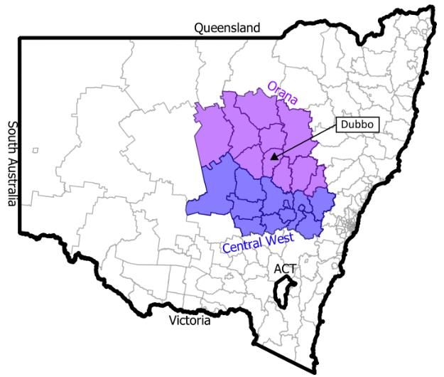
1.0         INTRODUCTION

The Dubbo City Regional Airport is one of the leading regional airports in Australia. The Airport is
located five (5) kilometres north-west of the Dubbo Central Business District on the Mitchell
Highway, and is situated on an overall land holding of 358 hectares.
The Airport provides a lifeline for Central and Western New South Wales in the provision of access
to Sydney, Brisbane, Melbourne and Newcastle by air. The Airport is also home to the Royal Flying
Doctor Service, NSW Rural Fire Services Fire Control Centre and Training Academy and a growing
General Aviation community. In addition, further development has recently been announced by the
NSW State government in the form of a NSW Police Service training facility.
The Airport is operated and maintained by Dubbo Regional Council in conjunction with the Regular
Public Transport (RPT) airlines and the Civil Aviation Safety Authority.
The Airport hosts direct return services from Dubbo to Sydney serviced by Qantas Link and
Regional Express. Regional Express also provide services to Broken Hill. Fly Corporate provides
daily services to Melbourne (Essendon) and Brisbane and Fly Pelican provides services between
Dubbo and Newcastle.
The Dubbo City Regional Airport is strategically vital to the region, serving not only Western NSW
but a large area of the Central West and north-west of the State. The facility is the largest airport in
the Orana and Central West Regions and provides services for a catchment in excess of 200,000
persons.
The Airport in 2017 had a total of 216,489 passengers utilising 7,500 RPT services (inbound and
outbound flights1).
The Airport also has significant general aviation activity with a total of 7,941 movements2 during
2017. The general aviation movements comprise all aircraft that may be operating charter, flight
training, air freight and other private aviation, emergency services, military and recreational aircraft.
The Airport is also used for the purposes of refuelling transiting aircraft.
The considerable land holding and investment particularly by emergency services in the Airport, the
continued population and business growth in the Orana and Central West Regions, the growth of
mining operations and the potential for general growth of industry in Dubbo and the Orana Region
has resulted in Dubbo Regional Council undertaking this review of the 2015-2036 Master Plan.

1   Bureau of Infrastructure, Regional Development and Cities April 2019
2   Avdata April 2019

    Ref: B19103AR001Rev4                                     - 1 -                Dubbo City Regional Airport
                                                                                    Master Plan 2019 – 2040
2.0 PURPOSE
This Master Plan 2019 – 2040 is a strategic document which will guide future development
decisions to achieve the sustainable growth and development of RPT and GA operations and
facilities at the Airport and to ensure the Airport can capitalise on any future business and
commercial development opportunities as the largest airport in the Central West, Orana and
Western NSW.
Dubbo Regional Council, as the owner and operator of the Dubbo City Regional Airport, has
pursued a program of planned growth and development over time with the first Master Plan
prepared for the facility in 1997. Following completion of the first Master Plan in 1997, consultants,
Airplan, undertook preparation of a Facilities Area Master Plan Review in 2002 as a review of the
1997 Master Plan and to ensure future projected passenger growth for the next 20 years was
adequately provided for in respect of airport facilities.
Consultants Airbiz undertook preparation of a further Facilities Area Master Plan Review in 2008.
The purpose of this Review was to provide a snapshot of Airport growth and whether this was
keeping track with the development regimes provided in the 2002 Facilities Area Master Plan
Review. In addition, the purpose of the 2008 Review was to examine further opportunities for
commercial development on the Airport lands given the size of the landholding and the design of
the Airport facilities.
The 2008 Master Plan Review provided a snapshot in time of Airport operations and the general
state of regional airline operations. The Review placed a strong emphasis on airlines commencing
jet operations within a reasonable time period. However, this has not yet proved to be the case with
the Dubbo RPT airlines and other airlines that currently provide regional services predominately
operating turboprop aircraft.
This Master Plan 2019 – 2040 prepared by REHBEIN Airport Consulting on behalf of Council has
undertaken a review of landside and airside development and their relationships with each other
while taking into account trends and drivers associated with regional airport planning.
This Master Plan provides for the necessary strategic intent and guidance for the Airport to allow
regular operations up to and including Code 4D aircraft which could allow for Large Air Tanker
used for firefighting by the NSW Rural Fire Service (RFS).
The Master Plan also recognises Council’s commitment to enhancing transportation links between
key industrial areas and arterial roads – particularly the potential for larger scale freight
opportunities. The Master Plan recognises the Boeing 777 (B777) as a possible future aircraft for
freight operations and has considered the suitability of key facilities and a possible freight precinct
to accommodate B777 operations and similar aircraft in the future.
Ref: B19103AR001Rev4 - 2 - Dubbo City Regional Airport
Master Plan 2019 – 2040The Master Plan identifies key elements critical to positioning the progression and development of
the Airport as a strategic service for the greater Western Region, supporting strategic planning for
the facility to ensure Airport development keeps pace with the demands of the community.
2.1 MASTER PLANNING APPROACH
The approach adopted in the preparation of this Master Plan has included discussions with key
stakeholders of the Airport.
Figure 1 shows the general approach that has been adopted in the review of this Master Plan.
Figure 1: Master Planning Approach
• Project Inception and key Stakeholder discussion
• Preliminary draft Dubbo City Regional Airport Master Plan 2019 - 2040 for
Council and Dubbo City Regional Airport Working Party Review
• Draft Master Plan 2019 - 2040 for public and stakeholder consultation
• Review consultation submissions
• Final Dubbo City Regional Airport Master Plan 2019 - 2040
The specific objectives of the Dubbo City Regional Airport Master Plan 2019 – 2040 include the
following:
Undertake rational and strategic development of the Dubbo City Regional Airport
which is critical to support the economy of the Central West and Orana Regions of
NSW;
Ensure the strategic significance of the Airport continues to be recognised by all
levels of government;
Ensure a sustainable and long term financial plan is in place to provide adequate
funding for the maintenance and expansion of airside and landside infrastructure;
Ensure that expansion of Airport infrastructure keeps pace with community needs
and aviation trends;
Ref: B19103AR001Rev4 - 3 - Dubbo City Regional Airport
Master Plan 2019 – 2040 Enhancement of the existing runway and taxiway systems to remove weight
limitations that currently exist and which are currently overcome by way of
concessions for certain aircraft types.
Ensure the Passenger Terminal is continually developed to accommodate the
expected increase in passenger numbers and RPT movements;
Recognition and development of commercial opportunities within the terminal
precinct inherent and implied by growth projections;
Increase take-off distance available on the main runway when required within
existing airport boundaries to increase the range and payload of departing aircraft;
To identify issues of energy supply and the influence of availability of energy in the
development of the Airport;
Develop land surplus to the needs of aviation in a manner designed to generate
funding to service the massive cost of maintaining the facilities and at the same time
relieve the community of that cost in part or in total; and
Examine any future development opportunities for freight use and activity in
conjunction and consultation with key industry types and groups; and
Ensure the RPT Apron and associated infrastructure is continually developed in
accordance with the future growth characteristic of the Airport.
Ensure the maintenance of current assets and provide the flexibility to maintain
assets with enhanced levels of service in response to market demands.
The Master Plan will be subject to a biennial review to ensure that development
timing remains consistent with the future planning of the Airport.
Ref: B19103AR001Rev4 - 4 - Dubbo City Regional Airport
Master Plan 2019 – 20403.0 DUBBO CITY REGIONAL AIRPORT
Dubbo City Regional Airport is situated in the Dubbo Regional Local Government Area and
occupies 358 hectares of land designated as SP2 Infrastructure: Air Transport and Emergency
Services Facilities. The airport is owned and operated by the Dubbo Regional Council and a brief
history of the Airport is provided in Section 3.4.
3.1 LOCATION
Dubbo City Regional Airport is located five (5) kilometres north-west of the Dubbo Central Business
District, on the Mitchell Highway. The Airport is accessed directly off Mitchell Highway via Arthur
Butler Drive which runs along the western airport boundary. The Airport location is illustrated on
Figure A at Appendix A.
The Airport Ring Road and the wider traffic movement system on airport are considered to provide
adequate vehicular access to the airport based on the current traffic generation and overall activity.
3.2 EXISTING AIRSIDE FACILITIES
The existing airside facilities are shown on Figure B at Appendix A.
3.2.1 RUNWAYS
Dubbo City Regional Airport has two sealed runways. The main runway is oriented roughly north-
east – south-west and is designated Runway 05/23, and the secondary runway is orientated
roughly east – west and designated Runway 11/29.
Runway 05/23
Runway 05/23 is the main sealed runway at the Airport. Runway 05/23 has an overall length of
1,706 metres and an overall width of 45 metres. The Runway is situated within a designated 150
metre wide runway strip. Runway End Safety Areas must be provided at the end of a runway strip,
to protect the aircraft in the event of undershooting or overrunning the runway.
The runway is equipped with low intensity runway lighting and a single-sided Precision Approach
Path Indicator (PAPI) system at each end. The runway is classified by the Civil Aviation Safety
Authority (CASA) as a Code 3 non-precision instrument runway.
The heaviest RPT aircraft currently using the runway is the Bombardier Q400 operated by Qantas
Link which has a maximum take-off weight of 29 tonnes and is classified as a Code C aircraft. The
Airport also hosts periodic visits from RAAF aircraft including C130 Hercules and Challenger CL
604 jets.
The length of Runway 05/23 adequately services the current range of aircraft movements.
Ref: B19103AR001Rev4 - 5 - Dubbo City Regional Airport
Master Plan 2019 – 2040The Aircraft Classification Number/Pavement Classification Number (ACN/PCN) system of
classification of pavement load carrying capacity is a procedure whereby the loading characteristics
of an aircraft are compared with the supporting capacity of a pavement.
The pavement of Runway 05/23 is rated in the Airservices Australia publication En-Route
Supplement Australia (ERSA) FAC YSDU (23 May 2019) as having an overall Pavement
Concession Number of 19 / F / C / 1100 (160 psi) / T. The runway pavement is flexible on a
subgrade strength category of low (C). The pavement is suitable for a maximum aircraft tyre
pressure of 1,100 kPa (160 psi).
The Aircraft Classification Number of typical RPT aircraft operating into the Airport is provided in
Table 1 below.
Table 1: Common RPT Aircraft Classification Number (ACN)
Aircraft Maximum Take-Off Weight (tonnes) ACN
Bombardier Dash 8 Q200 16.5 8
Bombardier dash 8 Q300 18.6 9
Bombardier Dash 8 Q400 29.2 19
SAAB 340B 13.1 7
Embraer 135 20.1 12
Runway 11/29
Runway 11/29 (also referred to as the cross runway) is the secondary sealed runway at the Airport.
Runway 11/29 has an overall length of 1,067 metres and an overall width of 18 metres. The
Runway is situated inside a protected 90 metre wide runway strip. Runway 11/29 is classified as a
Code 2B non-precision instrument runway.
The cross runway is predominately utilised for the purposes of General Aviation flight training and
is used by the NSW Rural Fire Service during water bombing activities by Air Tractor and other
associated aircraft. The overall weight limitation is eight (8) tonnes which limits its use by RPT and
other larger aircraft.
3.2.2 TAXIWAYS
Taxiway Alpha
Taxiway Alpha (A) is a 23 metre wide taxiway that provides access from the RPT apron to Runway
05/23. Taxiway Alpha is suitable for use up to and including Code 3C aircraft. The taxiway also
meets the minimum width for Code D aeroplanes, however is not provided with the shoulders
which are required for Code D use.
Taxiway Alpha is suitable for night time operations due to the inclusion of taxiway edge lighting.
Ref: B19103AR001Rev4 - 6 - Dubbo City Regional Airport
Master Plan 2019 – 2040Taxiway Bravo
Taxiway Bravo (B) is a 15 metre wide, spray-sealed taxiway providing access between Runway
05/23 and the RPT apron. Taxiway Bravo is only suitable for use by up to Code 3C turboprop
aircraft with a wheel base less than 18 metres. Taxiway Bravo also has taxiway edge lighting and is
suitable for night time operations.
Taxiways Charlie, Delta and Echo
Taxiways Charlie is 10.5 metres wide and mostly suitable for Code B aircraft access. However,
Code B access to the GA Apron via Taxiway Charlie is constrained when aircraft are parked in
front of the Airmed, Airbush and/or Beal Aircraft Maintenance hangars.
Taxiways Delta and Echo are 10.5 metres wide and suitable for use by Code B aircraft with
Maximum Take-off Weight (MTOW) up to 8,000 kg.
Taxiway Delta (D) runs parallel to Runway 05/23 from Taxiway Bravo (B) to the Runway 23
threshold.
Taxiway Echo (E) provides Code B access to the GA apron from Taxiway D.
Taxiways Hotel, Juliet and Kilo
Taxiways Hotel, Juliet and Kilo are not yet designated in AIP-ERSA, but have recently been
constructed.
Taxiway Hotel (H) is 7.5 metres wide and provides access for Code A aircraft to the smaller private
lease lots from Taxiway Delta.
Taxiway Juliet (J) is 10.5 metres wide and provides access for Code B aircraft to the commercial
lease lots along the southern side of Runway 11/29 from Taxiway Delta.
Taxiway Kilo (K) is 10.5 metres wide and provides access for Code B aircraft to Runway 11/29
from the New GA Area commercial lease lots connecting to Taxiway Juliet.
3.2.3 APRONS
RPT Apron
The RPT Apron is situated adjacent to the passenger terminal and currently includes three Code C
aircraft parking bays for RPT traffic in front of the terminal building. The RPT apron accommodates
one Dash8Q400 and two SAAB340B simultaneously.
Two stand-off bays for smaller aircraft are provided at the southern end of the RPT Apron.
GA Apron
There is a limited number of tie down points for light aircraft to park on the grass area north-east of
the RPT apron. Light aircraft parking is also provided on the western end of the GA apron. Code B
access to the fuel bowser and to the Beal Aircraft Maintenance and Airbush hangars is available
Ref: B19103AR001Rev4 - 7 - Dubbo City Regional Airport
Master Plan 2019 – 2040via Taxiway E. However, access for Code B aeroplanes in to the GA Area via Taxiway C is
restricted due to aircraft parking in front of the Airmed, Airbush and Beale hangars.
RFDS Apron
The Royal Flying Doctor Service (RFDS) has a dedicated apron within the RFDS lease area
situated adjacent to Taxiway Echo. Recently, the RFDS has constructed four (4) aircraft shelters
for the purposes of passenger transfer and refuelling (CASA approval pending).
3.2.4 LANDING AND NAVIGATION AIDS
VOR/DME
A VHF Omni-Directional Radio Range (VOR) and Distance Measuring Equipment (DME) south-
east of the runways have recently been decommissioned by Airservices Australia.
NDB
Off airport is a Non-Directional Beacon (NDB) approximately one (1) kilometre west of Runway 05
threshold adjacent to the Mitchell Highway.
Visual Aids
A number of visual aids are provided at the Airport as listed below:
Pilot activated low-intensity lighting on Runway 05/23;
Precision Approach Path Indicator (PAPI) system on the left-hand side of Runway
05 and Runway 23;
Two Illuminated Wind Director Indicators (IWDI), one located between Taxiways A
and B, the other to the left of Runway 23 threshold;
One non-illuminated wind indicator located to the left of the Runway 11 threshold;
Edge lighting on Taxiways Alpha and Bravo;
Pavement markings on both runways, taxiways and aprons; and
An Automatic Weather Station (AWS) and Automated Weather Information Service
(AWIS).
3.2.5 FUEL SUPPLIERS
Air BP is situated in a dedicated compound adjacent to the RFDS facility. Direct access is available
to the airside apron. Landside access is available from Judy Jakins Drive (off Cooreena Road).
Air BP has one above-ground 55,000 litre tank supplying Avtur. There is further land available in
this area to facilitate the construction of an additional tank.
VIVA comprises a split operation with the provision of a main storage facility fronting the western
end of the GA apron and an additional storage tank and self-serve bowser located in the airside
secure area at the eastern end of the GA apron. VIVA also has a dedicated office area off Judy
Jakins Drive.
Ref: B19103AR001Rev4 - 8 - Dubbo City Regional Airport
Master Plan 2019 – 20403.3 EXISTING LAYOUT AND USERS
Dubbo City Regional Airport consists of a passenger terminal area, general aviation (GA) area,
emergency services area and privately leased lots refer Figure C at Appendix A.
Access to the passenger terminal area is via Arthur Butler Drive and the Airport Ring Road. Access
to the GA area is via Cooreena Road as illustrated on Figure B at Appendix A.
3.3.1 TERMINAL AREA
The terminal area includes the passenger terminal building, car parking area, undercover security
car parking, and a hire car area as illustrated on Figure C at Appendix A.
Passenger Terminal
The passenger terminal building incorporates a number of facilities, including the following:
Check-in area providing check-in facilities for Fly Corporate, Qantas Link, Regional
Express and Fly Pelican;
Passenger screening security point;
Secured airside departure lounge area incorporating a cafe and associated
passenger facilities;
Arrivals hall including one baggage carousel; and
Car rentals desk area which provides facilities for five (5) car rental companies
Additionally one (1) space is being used by tourism operator Warrior War Birds.
The check-in area and security screening point operate efficiently for the range of services and
passengers currently utilising the airport. The check-in area includes six (6) check-in desks, all of
which are currently used by the airlines. There is space for the installation of one (1) additional
desk.
Expansion of the departure lounge area was undertaken by Council in 2013 in conjunction with the
implementation of passenger screening. Passenger screening facilities were introduced at the
Airport in March 2013 as a result of Qantas Link commencing operation of the Dash 8 (Q400
series) aircraft. All passengers are screened, whether travelling on Qantas Link Q400 services,
other Qantas Link services and /or other airlines.
The existing baggage claim unit is shared by all airlines that currently operate to Dubbo. A single
unit is currently adequate for the operational requirements of the airlines and their associated
schedules.
General Car Parking
The Airport provides a large vehicle parking area to the west of the passenger terminal. This
parking area provides approximately 325 vehicle parking spaces. There is no parking charge for
this pubic parking space.
Ref: B19103AR001Rev4 - 9 - Dubbo City Regional Airport
Master Plan 2019 – 2040Vehicle access to the parking area is directly available from Arthur Butler Drive via the Airport Ring
Road. Pedestrian access to the parking area is a short walk from both the departures and arrivals
areas through a pedestrian crossing across Arthur Butler Drive/Airport Ring Road.
Secure Vehicle Parking
A secure and undercover vehicle parking area is located to the north of the passenger terminal.
This area has traditionally been well patronised and is utilised by both business and leisure
travellers. Payment systems are situated in the arrivals area of the passenger terminal and the
egress point from the parking area.
Vehicular access to the secure vehicle parking area is directly available from Arthur Butler
Drive/Airport Ring Road. Pedestrian access is through a short connection to the arrivals hall area.
The technology associated with the parking payment system has been raised by stakeholders as
being temperamental. Council has indicated that it will seek a further review of the current facilities
and new technologies for vehicle parking.
Hire Cars
The airport has a number of hire car companies currently providing services from the airport.
Thrifty, Budget, Avis and Hertz currently lease terminal space in the form of a dedicated desk area
in the arrivals area and a set number of vehicle parking spaces.
Council, in June 2019, opened a new hire car parking area to the north-east of the passenger
terminal. The parking area can accommodate 118 vehicles. This has resulted in hire cars being
removed from the main parking areas, subsequently freeing up public spaces.
Airservices Australia
Airservices Australia currently leases an area of land south of the passenger terminal which
contains the decommissioned air traffic control tower and an associated compound. Council
advises the air traffic control tower is proposed to be removed in the future due to the nature of the
uncontrolled airspace around Dubbo and the presence of asbestos in the building. A date for
removal of the structure has not yet been confirmed however, it is anticipated that it will be
removed beyond 2020. The remaining Airservices building and associated equipment is planned to
be decommissioned however, if and when the facility will be removed is unknown.
3.3.2 EMERGENCY SERVICES AREA
Royal Flying Doctor Service (RFDS)
The Royal Flying Doctor Service (RFDS) operates six (6) Beechcraft Super King Air aircraft as air
ambulances from its facility within the GA area. The RFDS infrastructure includes treatment rooms,
associated offices, aircraft hangar and engineering facilities suitable for the storage of two (2) King
Air KA350 aircraft and an associated visitor centre. The RFDS facility also includes an apron area
suitable for the parking of two (2) King Air KA350 aircraft. It is understood that Western Area Health
also sublets part of the RFDS facility for Administration offices
Ref: B19103AR001Rev4 - 10 - Dubbo City Regional Airport
Master Plan 2019 – 2040The RFDS is expanding and building new infrastructure on site. The additions include the RFDS
Visitor Experience Centre which will also attract school visits, tour groups and will be an important
Airport asset. This facility allows four aircraft under cover, bays for passenger transfer and fuelling
aircraft, administration centre, pilots’ rest area, aeromedical nurse and a ‘nurse-on-call’ facility.
Some 40-50 staff members are employed on site. It is also understood that the RFDS is interested
in additional land for possible future extension opportunities or for the location of complementary
activities.
NSW Rural Fire Service
The NSW Rural Fire Service (RFS) District Headquarters are located on the north side of the GA
area west of the RFDS facility. The facility was constructed in this area in 2008 and currently
consists of an office building and associated sheds which are used for the storage of vehicles and
other equipment for the servicing of water bombing aircraft.
The facility was constructed in this location due to the synergies that exist between the RFS and
the water bombing services provided during fire events across the Central West.
The RFS have recently expanded to include a purpose built training facility adjacent the southwest
side of the GA apron. Council in 2017 partnered with the RFS to develop a ‘State of the Art’
Training Academy at the Airport. The facility has been recently completed and opened by the NSW
State Government. The facility will provide facilities for students to stay at the facility to learn and
build advanced fire-fighting skills and techniques.
Police Training Facility
A NSW police training facility is proposed to be located west of the GA Apron and is to be built for
up to 40 police officers at a time for training and simulation activities.
SES/VRA Headquarters
The State Emergency Services (SES) and NSW Volunteer Rescue Association (VRA) facility
provide emergency services facilities for the two organisations in the Dubbo region.
3.3.3 GENERAL AVIATION AREA
The General Aviation (GA) area consists of old and new sections.
The old GA area includes a total of 15 hangars utilised for a range of GA activities. This older GA
area is now surrounded by landside operations including NSW RFS, SES/VRA, Police training and
RFS training facilities, and the operations of the RFDS
Airmed Aeromedical
Airmed Aeromedical provides patient transport services by air and ground with multiple locations
around NSW and their head office based at Bankstown Airport in Sydney. The Dubbo location
stations two (2) fixed wing aero-medical aircraft, two (2) patient transport vehicles, two (2) full time
pilots, two (2) part-time pilots, a full time senior nurse and three (3) part time nurses for non-urgent
Ref: B19103AR001Rev4 - 11 - Dubbo City Regional Airport
Master Plan 2019 – 2040patient transfer between Dubbo and Sydney. The business also employs three (3) administration
staff and three (3) maintenance staff.
A Piper Chieftain aircraft is periodically parked the northern end of the GA apron. Loading of the
aircraft is typically undertaken at the southern end of the RPT apron, adjacent to the main security
gate for ambulance vehicle access. However, it is understood that the company that owns Airmed
Aeromedical has recently purchased AirLink and it is unsure as to their final operating activities for
the AirLink hangar and Airmed Aeromedical.
Beal Aircraft Maintenance
Beal Aircraft Maintenance is an aircraft maintenance organisation servicing remote NSW.
Typically, they maintain a wide variety of GA aircraft ranging from light fixed wing to air tractor
agricultural spraying/water bombing aircraft with up to 10 aircraft at any one time on airport for
servicing. Beal currently employs 10 people, and an additional four to five people from AirLink also
use the facility.
Beal Aircraft Maintenance currently occupies three (3) hangars on the south side of the GA apron
and is in need of aircraft parking spaces for customers. It is understood that Beal Aircraft
maintenance also sublets part of its facilities to AirLink engineers.
AirLink Pty Ltd
AirLink Pty Ltd, located next to the secure undercover car park, primarily provide charter services
with a fleet, which generally consisted of the following:
One (1) Beechcraft 1900D Aircraft;
One (1) x Cessna 310R; and
Two (2) x Piper PA-31 Piper Navajo Chieftain.
AirLink also has two (2) part-time pilots). AirLink operates in partnership with Airmed which is
dedicated to patient transfer.
Other Activities
Private operators with aircraft based at the airport total approximately 15 fixed wing aircraft. The
Airport is also home to Thomas Aviation who provides flight training and charter services.
In addition to operations based at Dubbo, a number of GA and military operations visit the airport
periodically. The airport hosts intermittent visits from Defence aircraft, fire bombing and other
aircraft such as the Beechcraft King Air, Pilatus PC9, and Challenger, Fokker 70 and Gulfstream
650 jets.
New GA Area
Additional lots have recently been made available to the north and east of the traditional GA area.
Four (4) lots for Code A aeroplanes to the east of the RFDS facility are provided. One (1) of these
now houses the aero club facilities and it is understood the other three (3) are leased.
Ref: B19103AR001Rev4 - 12 - Dubbo City Regional Airport
Master Plan 2019 – 2040Seven (7) lots for Code B aeroplanes are provided north of the RFDS with access to Runway 11/29
via Taxiway Kilo and access to Taxiway Delta via Taxiway Juliet parallel to Runway 11/29. The
RFS also has water tanks located at the north-west end of this area.
There is no landside access for the purposes of refuelling aircraft on these private lots. Fuel
operators have stated that their trucks do not currently have vehicle registration to drive on public
roads.
3.3.4 ITINERANT USERS
There are a number of itinerant users including fixed wing aircraft and helicopters. Helicopters
include military aircraft as well as air ambulance. Currently itinerant aircraft park in the aircraft tie-
down parking area.
3.3.5 ITINERANT AIRCRAFT PARKING
A grass tie down area is provided east of the RPT apron and additional central parking is available
on the GA apron area. These areas are operating at capacity.
3.4 HISTORY OF THE AIRPORT
As early as 1929, Australian Airways visited Dubbo looking to include the town on their schedule.
Land suggested for a landing strip was outside the municipality. At this time, aircraft had already
been landing in George Smith’s dairy paddock.
The first flights into Dubbo were in the early 1930s that consisted of aviation exhibition flights by
people such as Charles Kingsford Smith. At this time, the landing strip was in Wheelers Lane in the
vicinity of the now Orana Mall with the take-off north towards Myall Street.
Mr Tom Perry, who had been instrumental in establishing a landing strip at Narromine, purchased
land close to the present Dubbo Airport and commenced ‘working bees’ to clear the land of trees,
stumps and rocks. The official opening took place on 29 April 1935 when a Western Air Service
Plane (WASP) flew in from Trangie. The ribbon to commemorate the opening was cut by Mrs
Duffy, the Lady Mayoress at the time. The plane departed with a full complement of passengers.
WASP flew from Nyngan-Narromine-Dubbo to Sydney twice per week.
With Australia’s involvement in World War II came the RAAF Stores Depot. However, the one
thing Dubbo did not have was a suitable aerodrome for freight and stores in and out of the Depot.
The dirt airstrip was suitable only for small aircraft. The Commonwealth Construction Corps were
brought in to build an all-weather Military Airport on land resumed from the Fitzgerald’s property
‘Blizzard Field’.
The Local Member of the Legislative Council (MLC) of the day appealed to the district farmers to
take their tractors, trucks and anything suitable to help speed up completion of the work. Farmers
responded, as did local people, who would work all day and then spend time working on the airfield
construction. Stone for the foundation of the strip was carted from a property on the south
Ref: B19103AR001Rev4 - 13 - Dubbo City Regional Airport
Master Plan 2019 – 2040Burrabadine Road and gravel was carted from a property at Brocklehurst. The work was completed
in 1942.
Captain C A Butler of Butler’s Air Transport landed on the RAAF strip on a trial trip prior to
inaugurating a regular service to Sydney-Dubbo-Bourke-Charleville and other routes. The service
commenced in May 1946 following installation of radio equipment from No. 6 RAAF Stores Depot.
In June 1946, the Department of Civil Aviation took over the Dubbo Airport from the Military
Services and improved the bitumen runways and ancillary buildings. An air radio station was also
installed at this time.
On 1 July 1970, the former Dubbo City Council accepted the transfer of ownership of the Dubbo
Airport from the Department of Civil Aviation under the Airport Local Ownership Plan (ALOP).
Under this arrangement, Council owned, operated and maintained the aerodrome land as a
licensed aerodrome open for public use. A further change was made following the decision of
Council in September 1988 to accept the ownership and maintenance of the runway lighting. Whilst
Council owns the land, any alteration to the use of the land and buildings without the approval of
the Department of Transport at the time was not permitted.
In 1991, the Federal Government advised of its intention to divest itself fully of airport ownership,
and on 30 June 1992, a Deed between the Commonwealth and the former Dubbo City Council was
enacted, giving full ownership of the Airport to Council. For the City of Dubbo, this meant the
following:
Council to accept full responsibility for the Airport, including full funding
responsibility;
The Commonwealth to stop collecting landing charges and the Council to develop
its own overall charging regime to cover operational costs of the aerodrome
consistent with the standard of service demanded by the local community;
The Commonwealth to ‘write-off’ any past investment in the aerodrome;
The Government to consider funding works necessary to meet aviation industry
needs by providing a once-only non-attributable grant. In this regard, the
Government provided a grant of $200,000 for specified capital works; and
Responsibilities for all visual aids, which are site-specific, to be transferred to the
Council.
Ref: B19103AR001Rev4 - 14 - Dubbo City Regional Airport
Master Plan 2019 – 20404.0 PLANNING CONTEXT
4.1 REGIONAL CONTEXT
The Dubbo Regional Local Government Area (LGA) is located in the Orana Region of NSW and is
the gateway to western NSW. Dubbo is one of NSW’s growth centres, a hub with an increasing
population as people migrate away from Sydney seeking a tree-change. The City is a provider of
health, education, cultural services, business and retail services to surrounding areas.
Figure 2: Local Government Areas within the Central West and Orana Region
Dubbo has developed over time as a major service centre and is situated at the meeting point of
the Newell, Mitchell and Golden highways. The City is a five-hour drive from Sydney, four hours
from Newcastle and Canberra and a 10-hour drive from both Melbourne and Brisbane, being the
mid-way point between the two cities.
Dubbo is also a key hub for multiple transport modes – air carriers operating in excess of 166
flights per week in March 2019 to Brisbane, Sydney Melbourne and Newcastle as well as daily rail
connections to Sydney.
Ref: B19103AR001Rev4 - 15 - Dubbo City Regional Airport
Master Plan 2019 – 2040Approximately 80% of the Australian population can be reached within a 10-hour transport trip of
Dubbo – be it by road, by rail or by air. Dubbo’s strategic geographic position within NSW and its
regional catchment area (Orana), as well as the wider catchment area of western and north-
western NSW.
4.1.1 POPULATION
The Dubbo Regional LGA has a population of more than 52,000 people with 77% of those
(approximately 42,000 people) living in Dubbo City. The remaining population is located in
Wellington (8,000 people) and across its regional villages.
As a regional hub, Dubbo services a broader population of 120,000 people within the Orana region
and approximately 200,000 people across Central and Western NSW.
Dubbo’s economic prominence is reflected in its ongoing population growth and stable economy.
Table 2 below indicates that between 2006 and 2016 Dubbo City experienced an overall
population increase of 8.88 per cent compared to 3.34 per cent for the Orana region and 12.45 per
cent for NSW. The annual growth rate during this period sees Dubbo City with an average annual
rate of 1.78 per cent versus 2.49 per cent for NSW.
Table 2: Comparative Population Statistics for Dubbo City
Former Dubbo
Year Dubbo LGA Regional LGA Orana Region NSW
2006 37,845 45,967 114,626 6,549,174
Population 2011 38,808 47,302 115,652 6,917,656
2016 41,532 50,075 118,590 7,480,230
2006 - 2011 963 1,335 1,026 368,482
Pop. Increase 2011 - 2016 2,724 2,773 2,938 562,574
2006 - 2016 3,687 4,108 3,964 931,056
2006 - 2011 2.48 2.82 0.89 5.33
Pop. Increase (%) 2011 - 2016 6.56 5.54 2.48 7.52
2006 - 2016 8.88 8.20 3.34 12.45
2006 - 2011 0.50 0.56 0.18 1.07
Annual Growth
Rate (%) 2011 - 2016 1.31 1.11 0.50 1.50
2006 - 2016 1.78 1.64 0.67 2.49
Source: Dubbo Regional Council
In line with available projections, Dubbo City’s annual population growth rate is projected to
continue to trend strongly over the coming years as it attracts people from smaller towns within the
Orana region (for education and for employment in construction, manufacturing and in health
services), but also from Sydney as families move for lifestyle purposes and prosperity based on the
strength of the Dubbo economy. Dubbo City’s population is expected to exceed 46,000 by 2036
while Dubbo Regional LGA’s population is projected to exceed 60,000 people by 2036.
Ref: B19103AR001Rev4 - 16 - Dubbo City Regional Airport
Master Plan 2019 – 20404.1.2 INDUSTRY
The Orana region specialises in mining and agriculture – production of raw materials which are
transported for manufacturing and processing, either in Dubbo or to markets out of the region.
Dubbo is a service centre and specialises in construction, manufacturing and services such as the
provision of health care and aged cared for the Orana region and wider NSW, which accounts for
16.5% of employment in Dubbo – both the largest share of jobs and the greatest contributor in
value add to the Dubbo economy.
However Dubbo’s construction and manufacturing sectors are strong performers as they have
ready access to raw materials, livestock and other agricultural commodities as well as skilled
labour from across the Orana region.
Table 3 below illustrates Dubbo is a strong contributor to the Orana Region’s economy and both
Dubbo and Orana boast low unemployment rates against the NSW state average.
Table 3: Comparison GRP and Employment/Unemployment Statistics
Dubbo Regional LGA Orana Region NSW
Gross Regional/State Product $3.43 Billion $8.08 Billion $576.72 Billion
Output $6.6 Billion $16 Billion $1.2 Trillion
Total Employment (People/Jobs) 22,957 49,871 3,358,119
Unemployment Rate 2.5% 2.2% 4.7%
Source: REMPLAN - Economic Modelling and Planning System
Total number of jobs in the Dubbo region is approximately 23,000 (2017), with approximately 1,600
of these jobs in the tourism sector. The Dubbo region currently has an unemployment rate of 2.7%,
which is almost half that of the NSW unemployment rate of 5.3% (March 2018).
4.1.3 TOURISM
Dubbo is home to the Taronga Western Plains Zoo (TWPZ), which attracted 260,000 visitors in
2017-18. Other regional attractions include: the Wellington Caves, a 40-minute trip from Dubbo,
which will soon boast a new $4.2M visitor experience centre; the historic Dundullimal Homestead,
believed to be the oldest sophisticated slab house in Australia; the Dubbo Observatory offering
both day and night stargazing; the Old Dubbo Gaol; and the Royal Flying Doctor Service visitor
centre.
4.2 LOCAL CONTEXT
4.2.1 DUBBO COMMUNITY STRATEGIC PLAN
The Dubbo Community Strategic Plan (CSP) is the highest level of strategy that will guide and
influence the actions and initiatives of Dubbo Reginal Council, the community, all tiers of
Ref: B19103AR001Rev4 - 17 - Dubbo City Regional Airport
Master Plan 2019 – 2040government and community stakeholders through to 2040. The Plan includes five principal themes
and a number of strategies and outcomes.
The community, in development of the CSP, expressed a need for the Dubbo City Regional Airport
as a freight hub for our region to Asia and beyond and to … continue to provide services to its
current destinations as contained within Theme 2: Infrastructure and Theme 3: Economy
respectively. The requirement of the community is contained in Principal Theme 2.4 that the
community and business have convenient air access to a variety of destinations.
4.2.2 DUBBO URBAN AREAS DEVELOPMENT STRATEGY 1996
The Dubbo Urban Areas Development Strategy was first adopted by Council in 1996 and is made
up of the following strategies:
Residential Areas Strategy;
Employment Lands Strategy
Recreational Areas Strategy; and
Future Directions and Structure Plan (Part 1 and 2).
The Strategy forms the basis for the land use zonings and planning controls provided in the Dubbo
Local Environmental Plan 2011.
Residential Areas Development Strategy
At the core of the Residential Areas Development Strategy is the significant emphasis of further
residential development being undertaken in West Dubbo which will ensure the Dubbo Central
Business District is situated at the centre of the Dubbo urban area. The Strategy also provides for
further in-fill development to be undertaken in the south-east of the City.
The Strategy was reviewed by Council in 2007 as part of the review of the Dubbo Urban Areas
Development Strategy with the preparation of the Dubbo Urban Areas Development Strategy
Discussion Paper. The Strategy was again reviewed in 2009 in the process of preparation of the
Dubbo Local Environmental Plan (LEP) 2011.
The airport is located within a reasonable proximity to the north-west Residential Urban Release
Area as contained in the Dubbo LEP 2011. This area of the City will form one of the major
residential development fronts over the next 30 years. This area of the City is recognised as having
the potential to accommodate approximately 2,600 residential allotments or up to 10,000 persons,
over time.
Ref: B19103AR001Rev4 - 18 - Dubbo City Regional Airport
Master Plan 2019 – 2040Employment Lands Strategy
The Employment Lands Strategy is the newest component of the Urban Areas Development
Strategy that was adopted by Council in March 2019. The Strategy aims to ensure that the City of
Dubbo has an appropriate level of commercial, industrial, institutional and tourist zoned land in the
future which is situated in locations that can best meet the long-term requirements of Dubbo and
the Region.
The Dubbo City Regional Airport is included in the Hierarchy as a Specialised Activity Centre. The
Strategy identifies two Specialised Precincts of which the Airport Precinct is one that provides its
own unique benefit to Dubbo and the surrounding region. The Airport is located within Industrial
Candidate Area 2 – Airport Precinct which was identified as a long term industrial expansion area
given its location and access to the airport and highway. Its identified role is to allow development
and industries related to the airport including air freight and transport, road transport as well as
compatible light industrial and agricultural services.
4.2.3 DUBBO LOCAL ENVIRONMENTAL PLAN 2011 (LEP)
The Dubbo Local Environmental Plan 2011 (LEP) provides the overall land use zoning regime for
the Dubbo Local Government Area, guiding the permissibility of development and specific
provisions in relation to heritage conservation and environmental management of lands.
The LEP provides a zoning of SP2 Infrastructure over the airport lands. The SP2 Infrastructure
zone provides the following objectives for development:
To provide for infrastructure and related uses; and
To prevent development that is not compatible with or that may detract from the
provision of infrastructure.
The SP2 zone provides the following in relation to the permissibility of development:
The purpose shown on the Land Zoning Map, including any development that is ordinarily
incidental or ancillary to development for that purpose.
Any development included in the Master Plan which does not have a clear and identifiable
relationship with airport operations may require a rezoning or planning proposal process to be
undertaken. This process can be further considered prior to the provision of infrastructure and
associated development as included in the Master Plan.
4.2.4 DUBBO DEVELOPMENT CONTROL PLAN 2013
The Dubbo Development Control Plan 2013 (DCP) was prepared by the former Dubbo City Council
in 2013 to further assist and explain the requirements of the Dubbo Local Environmental Plan 2011
and to include specific provisions for development proposals. The DCP commenced operation on 6
May 2013.
Ref: B19103AR001Rev4 - 19 - Dubbo City Regional Airport
Master Plan 2019 – 2040The DCP Section 3.6 Dubbo City Regional Airport Controls includes the airport operations
overview, the Obstacle Limitation Surface (OLS) for the airport and the Australian Noise Exposure
Forecast (ANEF) mapping. Both the OLS and ANEF requirements were included in the DCP to
ensure proponents of development proposals surrounding the Airport were required to take into
account the impacts of the airport on any development activities.
4.3 LAND USE
The airport is located approximately five (5) kilometres north-west of the Dubbo Central Business
District and is situated on the Mitchell Highway. The general land use activities in the vicinity of the
airport are shown in Figure D at Appendix A.
Industrial land use activities predominately adjoin the airport to the south and to the west. This
includes light industrial and warehouse activities to the south and transport and logistics activities
including warehousing to the west. The airport also immediately adjoins approximately 96 hectares
of land zoned IN3 Heavy Industrial under the provisions of the Dubbo Local Environmental Plan to
the west. At the present time, these lands have not yet been developed and currently contain single
dwelling houses. Council recently purchased two (2) lots at the western end of the Runway 11/29
and assumed within the airport boundary. The land zoned for industrial development south of the
airport is contained in the Dubbo Industrial Areas Development Strategy as an Industrial Candidate
Area as being suitable for transport, warehousing and associated logistics.
The airport adjoins land zoned RU2 Rural Landscape to the north and north-east. These lands
predominately each contain a dwelling house and are utilised for limited rural production purposes.
It should be noted that these lands have minimal opportunities for further development of
residential housing based on the large minimum allotment size for subdivision and the permissible
development types afforded to the land under the provisions of the Dubbo Local Environmental
Plan 2011.
Land zoned low density residential development to the east consists of 360 hectares and forms the
north-west Residential Urban Release Area.
4.3.1 BIODIVERSITY
The Airport land holding is not known to have any threatened flora or fauna or Endangered
Ecological Communities (EEC). However, two areas of remnant vegetation are immediately to the
north-east and south-east of the subject site.
The LEP includes biodiversity mapping for the overall Dubbo Local Government Area (LGA). Land
with biodiversity values is mapped as either having medium or high biodiversity.
Figure 3 shows the extent of biodiversity mapping in the vicinity of the airport lands. Both
vegetation areas have the potential to provide habitat for kangaroos and bird life which can impact
airport operations. It is considered that the area of vegetation to the south-east is unlikely to be
impacted by current and future operations. However, the area of vegetation to the north- east may
Ref: B19103AR001Rev4 - 20 - Dubbo City Regional Airport
Master Plan 2019 – 2040be impacted. Any future development on the airport lands, where native vegetation is proposed to
be removed, will require environmental assessment to be undertaken. In addition, further
augmentation of Airport facilities may require assessment under the NSW state government
Biodiversity Offset Methodology.
Figure 3: Airport Surrounds Biodiversity Mapping
4.3.2 GROUNDWATER
The airport land holding has a relatively high groundwater table when considered in the context of
other lands in Dubbo. This high water table has impacted infrastructure works at the airport over
time.
The Dubbo LEP 2011 includes groundwater vulnerability mapping for the overall Dubbo LGA. Land
is either mapped as having high or medium groundwater vulnerability. The airport land is entirely
within the high groundwater vulnerability mapping which means it will require detailed geotechnical
assessment and the appropriate design of infrastructure including the construction of aprons,
taxiways, extension of (the main) Runway 05/23 and any building works.
Ref: B19103AR001Rev4 - 21 - Dubbo City Regional Airport
Master Plan 2019 – 20404.3.3 STORMWATER
Stormwater drainage for the developed component of the airport lands is carried by an open
stormwater drain that traverses the site from south to north as shown below in Figure 4.
Additional development activities proposed in the Master Plan have required stormwater
infrastructure works to accommodate the uses. Council at the time of writing adjusted the alignment
of the open stormwater channel to the west closer to Cooreena Road and underground
connections are provided to accommodate road and development infrastructure.
Council has also purchased neighbouring properties on the western boundary and north of the GA
area for the purposes of providing additional stormwater infrastructure. Future infrastructure will
need to ensure that any detention or other catchment ponds are only temporary to serve the
immediate purpose of managing stormwater flows. Ponds should not hold water long term in order
to avoid attracting wildlife hazards as discussed in Section 9.2.3
Figure 4: Open Stormwater Channel
4.4 AVATION REGULATORY CONTEXT
Consideration of the aviation regulatory context is integral to ensure a safe and secure environment
for aviation operation. Dubbo City Regional Airport is a certified aerodrome by the Civil Aviation
Safety Authority (CASA).
The Civil Aviation Safety Regulations Part 139 (CASR Part 139) requires an operator of an
aerodrome used for Regular Passenger Transport operations to have an Aerodrome Certificate.
Accordingly, Dubbo City Regional Airport became a Certified Aerodrome on 5 April 2006
(Certification number 1-6EDH).
Ref: B19103AR001Rev4 - 22 - Dubbo City Regional Airport
Master Plan 2019 – 2040CASR Part 139 empowers the Authority to specify standards and procedures relating to airports
used in air transport operations. The standards and procedures are set out in the CASA Manual of
Standards Part 139 – Aerodromes.
The Aviation Transport Security Act 2004 was enacted on 10 March 2005 which legislated that all
RPT airports, including Dubbo City Regional Airport, be classified as security controlled airports. As
a consequence of the introduction of the Qantas Link Bombardier Dash 8 Q400 aircraft, the Dubbo
City Regional Airport is now classified as a Category 3 airport, for security purposes, meaning that
passenger and baggage screening is in operation.
This legislation requires Council to maintain a Transport Security Program (TSP) which sets out the
manner in which Council will protect the Airport from unlawful security intrusions.
Ref: B19103AR001Rev4 - 23 - Dubbo City Regional Airport
Master Plan 2019 – 20405.0 STAKEHOLDER CONSULTATION
The Dubbo City Regional Airport Master Plan 2019 – 2040 has been prepared in consultation with
Council and stakeholders. Consultation with stakeholders was held in two separate formats. One
on-site session was held at the airport terminal building as well as telephone discussions with
individuals.
5.1 ON-SITE MEETING
Stakeholders were invited to an early morning session at Dubbo Airport on 21 March 2019 to
discuss what worked well at the airport and areas that may need attention. Attendees included Beal
Aircraft Maintenance, NTL, VIVA, council staff including the Airport Manager and Aerodrome
Reporting Officers.
Throughout the day REHBEIN Airport Consulting met separately with the Director of Economic
Development and Business, the Airport Manager, the Director Infrastructure and Operations,
Council Engineering staff and the Manager Strategic Planning Services, and the Manager Capital
Projects.
REHBEIN Airport Consulting conducted a site inspection and met with the RFDS at their premises.
5.2 TELEPHONE DISCUSSIONS
Telephone contact was made to various airlines, car hire companies and general Airport users as
provided by Council. All phone calls were made on 15 April 2019. Where phone contact was not
provided a brief email advised the stakeholder of the review taking place and welcomed their
feedback.
5.3 EMERGING THEMES
Generally, comments focussed around the positive growth of the Airport specifically in RPT
services and fire activity. The diversity in businesses and growth in emergency services at the
Airport is putting pressure on the Airport and its facilities. Stakeholders expressed the importance
of evaluating the layout to ensure areas are interconnected and can operate in a safe manner.
The key themes emerging from the consultation are listed below.
5.3.1 THEME 1: TERMINAL AREA
RPT Apron
Stakeholders expressed that the RPT apron was often congested particularly when an
unserviceable aircraft (which happens occasionally) parks on the apron. When this happens the
RPT apron is fully utilised and aircraft need to be moved out during peak periods.
Ref: B19103AR001Rev4 - 24 - Dubbo City Regional Airport
Master Plan 2019 – 2040Passenger Terminal Building
Extension to the terminal building was raised with stakeholders suggesting it will need to expand.
Comment was made on the terminal screening location that it is difficult to access the café and on-
airport employees are not using the facility.
Visitor attraction to the airport was considered important and could take the form of a viewing
platform, café or museum that provides a general meeting place which does not require visitors to
pass through passenger screening. Stakeholders feel such improvements would support and
attract business at the airport. Council undertakes a bi-annual survey of customers and continually
reviews and considers feedback provided.
Car Parking
Car parking was indicated as operating at capacity. Council has reported that the car rental
companies have grown by 60 to 70 percent in past year alone.
On site car parking was said to need to double in spaces either by extending laterally or providing
multi storey facilities. Interest was expressed for a car wash and possibly a petrol service station to
support the car rental services.
Aerodrome Reporting Officer (ARO) Base
Stakeholders expressed the need to provide the AROs a dedicated base for plant, equipment and
personnel. Currently the AROs use the existing Airservices building.
Taxiway D
The potential need for upgrading the parallel taxiway to Runway 05/23 (Taxiway Delta) to allow
Code C aircraft was noted by some operators, and it was identified that extended runway
occupancy time (especially when landing on Runway 05, or departing Runway 23) can sometimes
cause issues when there is a high amount of circuit traffic. As an interim and more cost-effective
solution, for landings on Runway 05, provision of a turning facility to allow 180 degree turns to be
executed along the runway would be beneficial to reduce runway occupancy time for larger aircraft.
Taxiway Delta was also raised in discussions as to how the extension would interact with terminal
and RPT apron expansion. The current master plan preserves the extension to connect to both
ends of Runway 05/23.
5.3.2 THEME 2: GENERAL AVIATION AREA
General Aviation Apron
Council raised concerns about aircraft parking on the south side of the GA apron and possibly
infringing the taxiway clearances. Stakeholders noted a number of competing activities are
occurring in the GA area such as local freight, medical transfers, and charter operations and
refuelling.
It was suggested that the GA area incorporate a dedicated drop/pick up area to prevent
unauthorised road vehicle access onto the apron.
Ref: B19103AR001Rev4 - 25 - Dubbo City Regional Airport
Master Plan 2019 – 2040You can also read