Coles Bay Reserves Glamorgan Spring Bay Council - NATIVE FLORA AND FAUNA MANAGEMENT PLAN
←
→
Page content transcription
If your browser does not render page correctly, please read the page content below
Glamorgan Spring Bay Council
   Coles Bay Reserves

NATIVE FLORA AND FAUNA
  MANAGEMENT PLAN
       2014 - 2019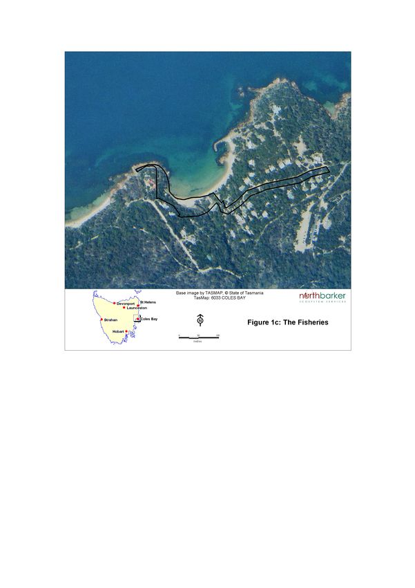
GSBC - Coles Bay Reserves
                                          Native Flora and Fauna Management Plan 2014 – 2019

                                   SUMMARY
North Barker Ecosystem Services has developed this five year Native Flora and Fauna
Management Plan on behalf of, and in consultation with, Glamorgan Spring Bay
Council for the Coles Bay Reserves under their management. The intent of the Plan is
to provide Council with a strategic approach to the sustainable management of the
vegetation and other natural values within the Reserves.
The Reserves are:
   •   Coastal Reserve around Coles bay foreshore
   •   Unnamed Reserve (off Coles Bay Road)
   •   Rita & Doris Reserve
   •   Harold Street Reserve
   •   The Fisheries
All the Reserves include substantial areas of native vegetation but also variously
incorporate public facilities and infrastructure.
The TASVEG native vegetation communities present across all Reserves include:
   •   Eucalyptus ovata forest (DOV)
   •   Eucalyptus ovata heathy forest (DOW)
   •   Eucalyptus globulus dry forest (DGL)
   •   Eucalyptus viminalis- Eucalyptus globulus coastal forest (DVC)
   •   Eucalyptus amygdalina coastal forest (DAC)
   •   Callitris rhomboidea forest (NCR)
   •   Allocasuarina verticillata forest (NAV)
   •   Acacia longifolia coastal scrub (SAC)
   •   Wet heathland (SHW)
   •   Heathland on granite (SHG)
   •   Coastal grass and herbfield (GHC).
Five of these (DOV, DOW, DGL, DVC and NCR) are listed as threatened communities
under the Nature Conservation Act 2002.
Other TASVEG non-native vegetation mapping units present are:
   •   Lichen lithosere (ORO) – the rocky foreshore
   •   Sand, mud (OSM) – sandy beaches
   •   Water, sea (OAQ) – small bays along the foreshore.
   •   Marram grassland (FMG)
   •   Urban areas (FUR).
Seven threatened plant species variously listed under the Tasmanian Threatened
Species Protection Act 1995 (TSPA) and Commonwealth Environment Protection and
Biodiversity Conservation Act 1999 (EPBCA) are present in the Reserves:
   •   Brachyloma depressum (TSPA: Rare)
   •   Caustis pentandra (TSPA: Rare)
   •   Conospermum hookeri (TSPA & EPBCA: Vulnerable)
   •   Spyridium vexilliferum var. vexilliferum (TSPA: Rare)
   •   Thryptomene micrantha (TSPA: Vulnerable)
   •   Xanthorrhoea arenaria (TSPA & EPBCA: Vulnerable)
   •   Zieria littoralis (TSPA: Rare).
Generally the vegetation is in good to excellent condition and provides a diversity of
habitat for native fauna. Threatened fauna species which may utilise nesting and/or

                                          i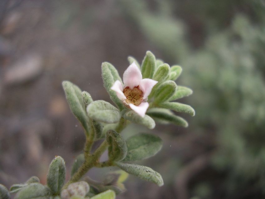
GSBC - Coles Bay Reserves
                                         Native Flora and Fauna Management Plan 2014 – 2019

foraging habitat in the vicinity include the new-holland mouse, Tasmanian devil,
spotted-tailed quoll, white-bellied sea-eagle and swift parrot.
Notable weeds are mapped and described. These include 3 species of ‘declared weeds’
under the Weed Management Act 1999 and 30 other species considered as
environmental weeds.
Management issues identified include:
    • Native vegetation, flora, fauna and significant trees
    • Weeds
    • Illegal clearing of vegetation
    • Reserve boundaries
    • Coastal erosion
    • Plantings and revegetation
    • Fire
Recommendations and actions plans are provided to deal with these issues and guide
management of the Reserves for all of their natural values whilst not compromising
their associated cultural and social values.

                                        ii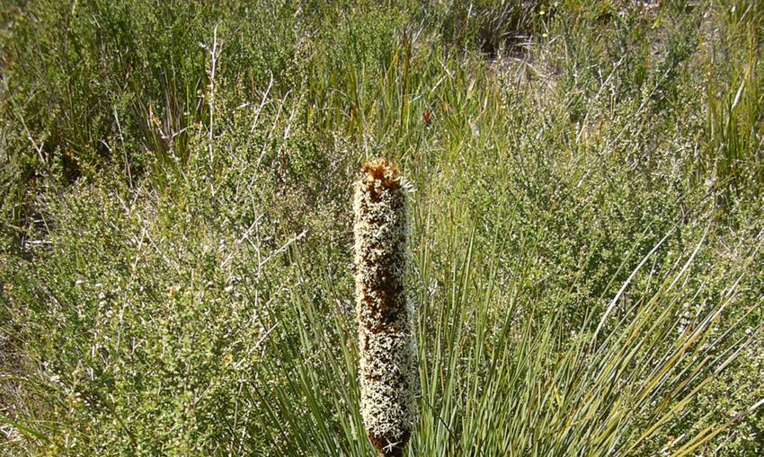
GSBC - Coles Bay Reserves
                                          Native Flora and Fauna Management Plan 2014 – 2019

ACKNOWLEDGMENTS
Project Management: Mel Kelly, Natural Resources Manager
Fieldwork: Dr. Nicky Meeson, Biodiversity Officer, (formerly North Barker
Ecosystem Services (NBES))
Report preparation: Dr. Nicky Meeson and Andrew North, NBES
Mapping*: Chris Obst, NBES
Consultation: Keith Breheny, Development Appraisals Officer and Tony Pollard,
Works Manager
Additional input from: David Tucker (Fire Management); Rosie Jackson,
(Aboriginal Heritage); Maureen Martin Ferris, East Coast Heritage Museum Curator
and Judie Hastie (Post European Settlement Heritage).
Community input: Members of the local community assisted in various capacities in
the development of this Plan and their contribution is greatly appreciated: Elaine
Rushbrook (Swansea) and Keziah Nunn (Coles Bay).
Photographs: Dr. Nicky Meeson, Biodiversity Officer

*Maps in this publication have been reduced from their original A3 format. Hard
copies of A3 maps are available upon request from:
NRM Department
Glamorgan Spring Bay Council
(03) 6256 4777

                                         iii
GSBC - Coles Bay Reserves
                                              Native Flora and Fauna Management Plan 2014 – 2019

                                        CONTENTS
1 . I N TR O D U C TI O N                                                                   1
  1.1 BACKGROUND                                                                        1
  1.2 GENERAL DESCRIPTION OF THE RESERVES                                               1
     Figure 1a – Location of the Reserves                    Error! Bookmark not defined.
     Figure 1b – Reserves around Coles Bay                   Error! Bookmark not defined.
     Figure 1c – The Fisheries                               Error! Bookmark not defined.
2 . S U M M AR Y O F BI O LO G I C AL C H AR A C TE R I S TI C S                            6
  2.1 VEGETATION                                                                            6
  2.2 FLORA OF CONSERVATION SIGNIFICANCE                                                    8
  2.3 FAUNA HABITAT                                                                        12
  2.4 FAUNA OF CONSERVATION SIGNIFICANCE                                                   12
  2.5 SIGNIFICANT TREES                                                                    12
  2.6 WEEDS                                                                                13
  2.7 PHYTOPHTHORA CINNAMOMI                                                               14
3 . D E T AI L E D D E S C R I P TI O N S O F TH E R E S E R V E S                        16
  3.1 COASTAL RESERVE                                                                        16
     Figure 2 – Coastal Reserve: vegetation, threatened flora & significant trees            18
     Figure 3 – Coastal Reserve: ‘declared’ and environmental weeds         Error! Bookmark not
     defined.
  3.2 UNNAMED RESERVE                                                                        21
     Figure 4 – Unnamed Reserve: vegetation and threatened floraError! Bookmark not defined.
  3.3 RITA & DORIS RESERVE                                                                   23
     Figure 5 – Rita & Doris Reserve: vegetation and threatened flora       Error! Bookmark not
     defined.
     Figure 6 – Rita & Doris Reserve: environmental weeds        Error! Bookmark not defined.
  3.4 HAROLD ST RESERVE                                                                      26
     Figure 7 – Harold St Reserve: vegetation and threatened floraError! Bookmark not defined.
     Figure 8 – Harold St Reserve: environmental weeds           Error! Bookmark not defined.
  3.5 THE FISHERIES                                                                          29
     Figure 9 – The Fisheries: vegetation and threatened flora Error! Bookmark not defined.
     Figure 10 – The Fisheries: environmental weeds              Error! Bookmark not defined.
4 . O TH E R R E S E R V E V AL U E S                                                     32
  4.1 CULTURAL HERITAGE                                                                    32
  4.2 RECREATIONAL VALUES                                                                  32
  4.3 EDUCATIONAL VALUES                                                                   32
  4.4 SUMMARY OF OTHER VALUES                                                              32
5 . M AN AG E M E N T I S S U E S                                                         33
  5.1 NATIVE VEGETATION, FLORA, FAUNA AND SIGNIFICANT TREES                                33
  5.2 WEEDS                                                                                33
  5.3 ILLEGAL CLEARING OF VEGETATION                                                       36
  5.4 RESERVE BOUNDARIES                                                                   36
  5.5 COASTAL EROSION                                                                      37

                                             iv
GSBC - Coles Bay Reserves
                                     Native Flora and Fauna Management Plan 2014 – 2019

  5.6 PLANTINGS AND REVEGETATION                                                  37
  5.7 FIRE                                                                        38
  5.8 PLAN REVIEW                                                                 40
6 . AC TI O N P L AN S                                                           41
  6.1 WEED ACTION PLAN                                                            42
  6.2 GENERAL ACTION PLAN                                                         43
REFERENCES                                                                       45
  APPENDIX 1 – SURVEY METHODS                                                     46
  APPENDIX 2 – VASCULAR PLANT SPECIES LIST                                        47
  APPENDIX 3A – REVIEW OF THREATENED FLORA                                        54
  APPENDIX 3B – REVIEW OF THREATENED FAUNA                                        60
  APPENDIX 4A – LEGISLATIVE OBLIGATIONS RELEVANT TO NATURAL VALUES OF
  RESERVES                                                                        63
  APPENDIX 4B – OTHER LEGISLATION AND POLICIES RELEVANT TO RESERVE
  MANAGEMENT                                                                      65
  APPENDIX 5A – DECLARED WEED PHOTOS                                              66
  APPENDIX 5B – ENVIRONMENTAL WEED PHOTOS                                         67

                                    v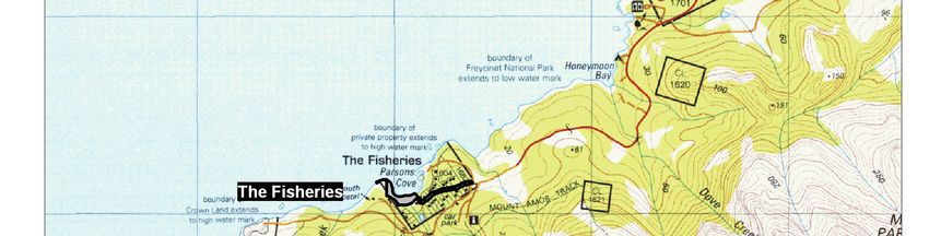
GSBC - Coles Bay Reserves
Native Flora and Fauna Management Plan 2014 – 2019
1. INTRODUCTION
1.1 B A C K G RO U N D
North Barker Ecosystem Services has developed this five year Native Flora and Fauna
Management Plan on behalf of, and in consultation with, Glamorgan Spring Bay Council
for the Coles Bay Reserves under their management. The intent of the Plan is to provide
Council with a strategic approach to the management of the Reserves’ natural values
whilst recognising and considering the Reserves’ significant cultural and social values.
Therefore the main objectives of the Plan are to:
• Identify the natural, and associated cultural and social values of the Reserves,
• Identify threats to the natural values,
• Provide action plans to ensure that the Reserves are sustainably managed to
preserve and enhance all of their natural values, in accordance with the
Tasmanian Reserve Management Code of Practice 20031, whilst not
compromising their cultural and social values, and
• Raise community awareness of the values of the Reserves and thereby encourage
participation in activities that minimise threats to their values.
1.2 G E N E R AL D E S C RI P T I O N OF THE R E S E RV E S
Coles Bay is situated on the central east coast, in the Glamorgan Spring Bay municipality
and in the Tasmanian South East bioregion2. It occurs in the dry subhumid warm
climatic zone where the annual average rainfall is in the region of 600 mm. The altitude
across all the Reserves ranges from sea level to approximately 25 m a.s.l.
The Reserves include four within the immediate vicinity of the town of Coles Bay and
one, The Fisheries, approximately 2 km directly south of the town. The general locations
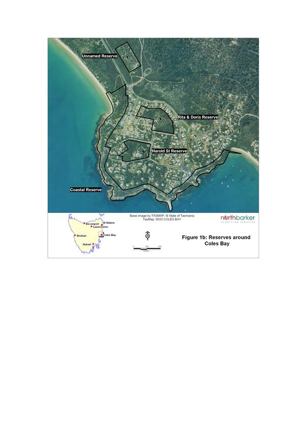
of the Reserves are depicted in Figures 1a, 1b and 1c. They are briefly described below and
more detailed descriptions of the vegetation and their other characteristics are provided
in Sections 2 and 3.
1Parks and Wildlife Service, Forestry Tasmania and Department of Primary Industries, Water and Environment 2003.
2IBRA5 – Peters & Thackway 1998. A bioregion is an area of land with similar environmental, physical and climatic
conditions and containing characteristic ecosystems.
1
GSBC - Coles Bay Reserves
                                                  Native Flora and Fauna Management Plan 2014 – 2019

Coastal Reserve
  PID: 1710282                                      Extent (ha): 12.9
  Land tenure: Coles Bay Conservation Area, Nature Conservation Act, Parks and Wildlife Service
  Management responsibilities: No current lease or license – previously held by Council.

  Natural features: Coastal vegetation including dry sclerophyll forest, non-eucalypt forest and
  non-forest communities, creek, rocky and sandy shores and bays, parkland with remnant native
  trees.

  Infrastructure & uses: Public roads, private property access roads & cross-overs, parking areas,
  informal walking tracks, BBQ & picnic tables, public toilets, boat ramps & jetties, electricity supply
  poles & cables.

Unnamed Reserve (off Coles Bay Rd)
  PID: 1769970                                      Extent (ha): 2
  Land tenure: Public Reserve, Crown Lands Act, DPIPWE
  Management: Crown License – Glamorgan Spring Bay Council

  Natural features: Dry sclerophyll forest and heathland communities contiguous on all sides with
  similar native vegetation.
  Infrastructure & uses: Fencing around perimeter.
Rita & Doris Reserve
  PID: 1703314                                      Extent (ha): 2
  Land tenure: Public Reserve, Crown Lands Act, DPIPWE
  Management: Crown Lease – Glamorgan Spring Bay Council

  Natural features: Dry sclerophyll forest and heathland communities, granite outcrops.
  Infrastructure & uses: Informal walking tracks, picnic tables with vehicular access & parking,
  lookout platform, Council depot shed.
Harold St Reserve
  PID: 5288285                                      Extent (ha): 2.5
  Land tenure: Authority Land, Crown Lands Act, DPIPWE
  Management: Crown Lease – Glamorgan Spring Bay Council

  Natural features: Non-eucalypt forest and parkland with remnant native trees.
  Infrastructure & uses: Community hall, public tennis courts & toilets with gravel access roads,
  cross-overs & parking, BBQ & picnic tables, children’s playground, ambulance and fire stations
  with cross-overs, informal walking tracks.
The Fisheries
  PID: 1805898 plus road reserve with no PID        Extent (ha): Foreshore–0.7; road reserve–0.5
  Land tenure: Coastal and road reserve - Glamorgan Spring Bay Council
  Management: Glamorgan Spring Bay Council

  Natural features: Coastal vegetation including dry sclerophyll forest and non-eucalypt forest,
  creek, rocky and sandy shores.
  Infrastructure & uses: Public road, private property cross-overs, informal walking track, boatshed
  & ramp, electricity supply poles & cables.

                                                2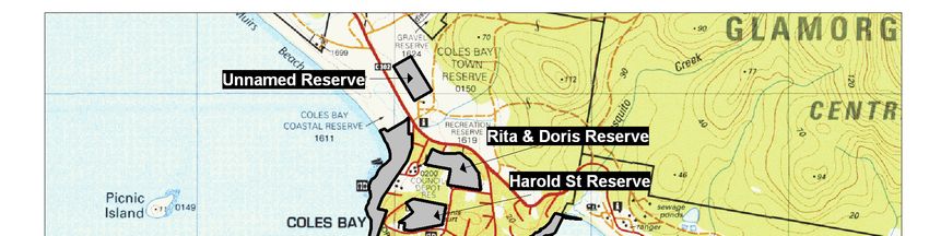
GSBC - Coles Bay Reserves
Native Flora and Fauna Management Plan 2014 – 2019

3
GSBC - Coles Bay Reserves
Native Flora and Fauna Management Plan 2014 – 2019

4
GSBC - Coles Bay Reserves
Native Flora and Fauna Management Plan 2014 – 2019

5
GSBC - Coles Bay Reserves
                                                                   Native Flora and Fauna Management Plan 2014 – 2019

2.   SUMMARY OF BIOLOGICAL CHARACTERISTICS
     The following summarises the natural values (vegetation, flora and fauna habitat) and
     other biological characteristics (weeds and plant pathogens) of the Reserves. A detailed
     description of each Reserve is provided in section 3.
     The information provided below is based on the results of a recent survey. The methods
     adopted for the survey and for assessment of conservation significance are provided in
     Appendix 1.
     A list of vascular plants that occur within the Reserves is provided in Appendix 2. A
     review of the potential of the Reserves to support threatened species known to occur in
     the vicinity is provided in Appendices 3A and 3B.
     The Council’s legislative obligations in relation to the management of threatened species
     and communities as well as weeds occurring in the Reserves are provided in Appendix
     4A. Other legislation and policies relevant to reserve management are provided in
     Appendix 4B.
     2.1 V E G E T A T I O N
     The on-ground survey revealed a much greater variation in the vegetation compared with
     current TASVEG3 mapping, which is very generalised. However, this is often the case
     with TASVEG due to issues of scale, aerial photo interpretation and lack of ground-
     truthing.
     Across all the Reserves there are eleven TASVEG native vegetation communities present.
     These include five dry eucalypt forest communities, two non-eucalypt forest
     communities, three scrub and heathland communities and one grassland community.
     Five of these communities are listed as threatened under the Nature Conservation Act
     2002 (NCA).
     The condition of communities varies although most are in good to excellent condition.
     Significant weeds infestations are limited in extent.
     Five other TASVEG mapping units are also present. Three of these are classified by
     TASVEG as ‘Other natural environments’. These are the rocky foreshore (Lichen lithosere
     – ORO), sections of sandy beaches (Sand, mud – OSM) and small bays along the
     foreshore (Water, sea – OAQ).
     The two other mapping units are Marram grassland (FMG) and Urban areas (FUR). For
     the purposes of this study, FUR has been differentiated into ‘FUR - parkland’ and ‘FUR -
     other’ in order to distinguish the wide variation within this mapping unit. Areas of ‘FUR
     – parkland’ have significant stands of remnant native trees but they could not technically
     be classified as a native vegetation community as they are virtually devoid of any native
     understorey. In contrast areas of ‘FUR – other’ are either built environments, such as
     buildings, roads and jetties, or have no native vegetation, such as grassy road verges or
     private gardens encroaching onto Reserves.
     Table 1 provides a list of all mapping units within the Reserves together with the
     conservation status of the native vegetation. The distribution of all mapping units across
     the Reserves, as mapped during the current survey, is depicted in Figures 2, 4, 5, 7 and 9
     in section 3. Detailed descriptions of each native vegetation community within each
     reserve is also provided in section 3.

     3   TASVEG is the abbreviation for the Tasmanian Vegetation Mapping Program (the vegetation map of the entire State)

                                                                 6
GSBC - Coles Bay Reserves
Native Flora and Fauna Management Plan 2014 – 2019
Table 1. Native vegetation communities and other TASVEG mapping units in
the Reserves.
Present in Reserve (+)
Coastal Reserve
Harold Street
The Fisheries
Listed under
Rita & Doris
Unnamed
the
Reserve
Reserve
Reserve
TASVEG Tasmanian
TASVEG community name
code Nature
Conservation
Act 2002
NATIVE VEGETATION
COMMUNITIES
DOV Eucalyptus ovata (black gum) Yes +
forest & woodland
DOW Eucalyptus ovata (black gum) Yes +
heathy forest & woodland
DGL Eucalyptus globulus (blue gum) Yes +
dry forest & woodland
Eucalyptus viminalis-E.
DVC globulus (white gum-blue gum) Yes +
coastal forest & woodland
Eucalyptus amygdalina (black
DAC peppermint) coastal forest & + + +
woodland
NCR Callitris rhomboidea (oyster bay Yes +
pine) forest
NAV Allocasuarina verticillata + +
(drooping sheoak) forest
SAC Acacia longifolia (coast wattle) +
coastal scrub
SHW Wet heathland +
SHG Heathland on granite +
GHC Coastal grass and herbfield +
OTHER NATURAL ENVIRONMENTS
ORO Lichen lithosere (rocks) + +
OSM Sand, mud (beaches) + +
OAQ Water, sea (small bays) +
NON-NATIVE VEGETATION
FMG Marram grassland +
FUR Urban areas + + + +
7GSBC - Coles Bay Reserves
Native Flora and Fauna Management Plan 2014 – 2019
2.2 F L O R A OF C O N S E R V AT I O N S I G N I F I C AN C E
A total of 222 vascular plant species were recorded during the survey including 7
threatened species and 55 introduced species. A full species list is given in Appendix 2.
Appendix 3A lists a total of 49 species of conservation significance previously recorded
within the vicinity together with a description of their preferred habitat and an
assessment of their likely occurrence within the Reserves.
In summary, apart from the 7 species recorded in the Reserves (see below for further
details), there are only a few other species that are considered as having a moderate,
moderate to high or very high potential to occur in the Reserves. This includes a few
orchid species, which would require further targeted surveys during the appropriate
flowering times to determine if they are present. The Unnamed Reserve has the greatest
potential to support other threatened species.
Threatened flora recorded in the Reserves
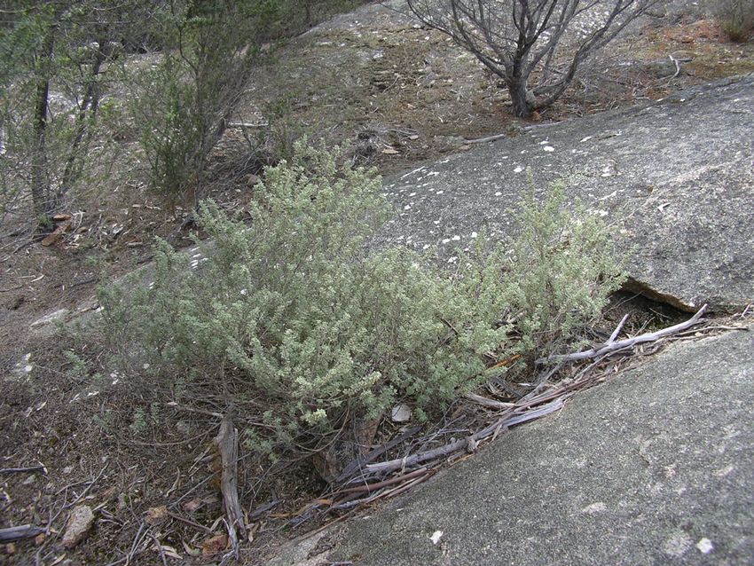
Brachyloma depressum - spreading heath (TSPA: Rare)
B. depressum occurs in eastern Tasmanian. It is a low shrub that grows to 1 m tall. It has
slender and wiry branches with lance-shaped leaves that taper to a sharp point and white
flowers. Flowering is from August to December.
It occurs in both the Rita & Doris and Harold St Reserves as locally scattered plants. Over
90 plants were observed across both Reserves (Plates 1 & 2; Figures 5 & 7).
Plate 1: Brachyloma depressum Plate 2: Brachyloma depressum
Caustis pentandra - thick twistsedge (TSPA: Rare)
C. pentandra occurs in mainly in the north-east and along the Freycinet peninsular. It is
a scrambling sedge that reaches a height of 70 cm and often branches at the nodes, or
stem joints.
It is very common in the Unnamed Reserve occurring in dense or scattered clumps
throughout the DAC community. An estimated 100 plants are present (Plates 3 & 4;
Figure 4).
8GSBC - Coles Bay Reserves
Native Flora and Fauna Management Plan 2014 – 2019
Plate 3: Caustis pentandra Plate 4: Caustis pendandra
Conospermum hookeri - tasmanian smokebush (TSPA & EPBCA:Vulnerable)
C. hookeri is endemic to Tasmania and occurs along the east coast. It is an erect shrub
that varies in height but can grow to over 2 m tall. It has long narrow leaves that are
covered in silky hairs. It produces a mass of small white flowers at the stem tips between
September and November.
At least seven plants occur in the Unnamed Reserve within the DAC community (Plates 5
& 6; Figure 4).
Plate 5: Conospermum hookeri Plate 6: Conospermum hookeri
Spyridium vexilliferum var. vexilliferum - helicopter bush (TSPA: Rare)
S. vexilliferum var. vexilliferum occurs in the eastern, northern and western Tasmania.
It is a low slender, much-branched shrub up to 90 cm tall. The leaves are narrow with a
hairless upper surface and the lower surface is covered with white or rust coloured hairs.
The flowers have 1 to 3 distinctive white velvety bracts. Flowering is from September to
January.
It is most abundant in the Rita & Doris Reserve where over 80 plants were observed. It is
also present as small localised populations in the Coastal Reserve and the Harold St
Reserve (Plates 7 & 8; Figures 2, 5 & 7).
9GSBC - Coles Bay Reserves
Native Flora and Fauna Management Plan 2014 – 2019
Plate 7: Spyridium vexilliferum var. Plate 8: Spyridium vexilliferum var.
vexilliferum vexilliferum
Thryptomene micrantha - ribbed heathmyrtle (TSPA: Vulnerable)
T. micrantha occurs on the east coast and in the midlands. It is a hairless shrub with
slender spreading branches which grows up to 1.2 m tall. The leaves are wedge-shaped
with a blunt tip. Small white flowers are borne along the stems. Flowering occurs from
late winter to spring.
It is abundant at The Fisheries in the DAC community where it has colonised previously
cleared areas both under the power cables parallel to the road and at the top of a steep
rise above the beach. Over 800 plants were observed (Plates 9 & 10; Figure 9).
Plate 9: Thryptomene micrantha Plate 10: Thryptomene micrantha
Zieria littoralis - downy zieria (TSPA: Rare)
Z. littoralis is confined to the central east coast. It is an erect shrub growing up to 2 m
tall. It has greyish-green leaves that are covered with short, velvety hairs. The small white
or pink flowers are produced in spring.
In occurs in the Rita & Doris Reserve in the SHG community. Over 80 plants were
observed growing in cracks in granite outcrops (Plates 11 & 12; Figure 5).
10GSBC - Coles Bay Reserves
Native Flora and Fauna Management Plan 2014 – 2019
Plate 11: Zieria littoralis Plate 12: Zieria littoralis
Xanthorrhoea arenaria - sand grasstree (TSPA & EPBCA: Vulnerable)
X. arenaria is endemic to Tasmania where it occurs in northern and eastern coastal areas
from Bridport to Coles Bay. This grass tree does not have an above ground trunk. The
sometimes greyish or bluish-green leaves are up to 80 cm long. The flower spike is
between one-third and one-half the length of the scape, or stem.
It occurs at the Unnamed Reserve. Grasstrees are often difficult to identify especially
when they are not in flower and there are also some recognised taxonomic difficulties
with this genus. Several grasstrees, some in flower, were observed both within the SHW
and DAC communities in this reserve. Many of these are certainly the more common
southern grasstrees (X. australis) but only one plant was identified as the threatened
sand grasstree. There are possibly more within this Reserve.
Plate 13: Xanthorrhoea arenaria
11GSBC - Coles Bay Reserves
Native Flora and Fauna Management Plan 2014 – 2019
2.3 F A U N A H A BI T AT
The diverse nature of the vegetation across all the Reserve equates to a diverse range of
habitat opportunities for native fauna, including mammals, birds, reptiles and a variety
of invertebrates.
Three of the Reserves, the Coastal and Unnamed Reserves and The Fisheries are all
contiguous with extensive areas of relatively undisturbed habitat in the Coles Bay area,
including the Freycinet National Park. The Rita & Doris and Harold St Reserves provide a
refuge of high quality habitat within the urban area, although neither is far removed from
the more extensive habitat in the area.
2.4 F A U N A OF C O N S E R V A T I O N S I G N I F I C AN C E
Appendix 3B lists threatened fauna species that have been recorded within the vicinity of
the Reserves or that are considered to have the potential to occur. A brief discussion is
given to indicate the reasons why habitat is suitable or unsuitable.
In summary, habitat present in the Reserves does not provide core breeding habitat for
any threatened fauna with the possible exception of the new holland mouse. However,
foraging habitat is present in the Reserves, or in the immediate vicinity, for the
Tasmanian devil, spotted-tailed quoll, white-bellied sea-eagle and swift parrot.
New holland mouse (Pseudomys novaehollandiae) (TSPA: Endangered)
The New Holland Mouse was thought to be extinct until re-discovered in the 1960s.
Recent surveys have confirmed its occurrence at various localities, all within 15 km of the
coast and below an altitude of 200m, including along the east coast of Tasmania. Here its
habitat preference is coastal dry heath on a sandy substrate with a dense and floristically
diverse understorey although it has been found in a variety of habitats including
woodland with an open understorey, Allocasuarina woodland and Juncus hardpan. It
has a strong association with certain heath plant species (e.g. Xanthorrhoea australis,
Hypolaena fastigiata, Aotus ericoides and Lepidosperma concavum).
It shelters and nests in 10 cm wide, deep burrows which it excavates in sandy soil, and
occasionally builds temporary twig nests at the base of tussocks or grass trees.
It is considered to be dependent on disturbance of its habitat by fire to maintain high
population densities. Densities are highest in vegetation burnt within 5 to 10 years where
seed producing legumes and epacrids are actively regenerating. Long unburnt habitat
results in the decline of mouse numbers and potentially local loss of populations.
Clearance of coastal heaths is the main threatening process. However, it may also be
threatened by the impact of Phytophthora cinnamomi on the heathlands. P. cinnamomi
can kill plant species that provide seeds for food and cover for protection.
The Unnamed Reserve has many characteristics that accord with core habitat for the
new-holland mouse. The DAC community is open woodland with a heathy understorey
that provides the habitat structure as well as the plant species associated with the mouse.
Additionally, the Reserve does not appear to be currently infected by P. cinnamomi. The
only unknown factor is the fire history. It does not appear to have been burnt recently
although it does appear to have regenerated following at least some clearing in the recent
past.
2.5 S I G N I F I C AN T T R E E S
In addition to the many trees within the native vegetation communities and within areas
mapped as ‘FUR – parkland’, there are a number of significant native trees along the
roadsides in the Coastal Reserve. They include large mature Tasmanian blue gums
(Eucalyptus globulus) and mature and old-growth white gums (E. viminalis) (Figure 2).
12GSBC - Coles Bay Reserves
Native Flora and Fauna Management Plan 2014 – 2019
Apart for the aesthetic, visual and cultural value of these trees, they provide valuable
foraging and nesting habitat for a range of native birds, including threatened species.
They may be utilised as perching sites by the threatened white-bellied sea-eagle and the
blue gums provide potential foraging habitat for the threatened swift parrot.
2.6 W E E DS
Fifty-five introduced species were recorded during the survey. Three of these are
‘declared weeds’ under the Weed Management Act 1999 and they are also all Weeds of
National Significance. Another 30 species are considered to be significant environmental
weeds. All of these species are listed in Tables 2A and 2B, a photograph of each is
provided in Appendices 5A and 5B, and their distribution is depicted in Figures 3, 6, 8
and 10.
It is evident from Tables 2A and 2B that the Coastal Reserve contains the most weed
species and the most widespread weed is sweet pittosporum, which was observed at 43
general locations.
It should be noted that the number of observations provided in Tables 2A and 2B are
intended to give a general indication of relative abundance and does not always reflect
actual abundance. For example, there is likely to be more than 43 sweet pittosporum
plants but it would have been impractical to map each one.
Table 2A. Declared and WONS* weeds recorded in the Reserves.
* ‘Declared weeds’ under the Weed Management Act 1999. WONS = Weed of National Significance.
** Observations = the number of general locations across the Reserves where it was observed.
Common name Scientific name Observations
Occurrence
**
Blackberry Rubus fruticosus 1 Coastal Reserve
Bridal creeper Asparagus asparagoides 1 Coastal Reserve
Montpellier broom Genista monspessulana 1 Coastal Reserve
Table 2A. Other environmental weeds recorded in the Reserves.
* Observations = the number of general locations across the Reserves where it was observed.
Common name Scientific name Observations
Occurrence
*
Agapanthus praecox
Agapanthus 1 Coastal Reserve
subsp. orientalis
Banana passionfruit Passiflora tarminiana 1 Coastal Reserve
Bears breeches Acanthus mollis 1 Coastal Reserve
Coastal Reserve
Blackberry nightshade Solanum nigrum 2
Harold St Reserve
Blue butterfly bush Psoralea pinnata 3 Coastal Reserve
Blue marguerite Felicia amelloides 4 Coastal Reserve
Blue periwinkle Vinca major 1 Coastal Reserve
Harold St Reserve
Bluebell creeper Billardiera fusiformis 3
The Fisheries
Cape ivy Delairea odorata 2 Coastal Reserve
13GSBC - Coles Bay Reserves
Native Flora and Fauna Management Plan 2014 – 2019
Common name Scientific name Observations
Occurrence
*
Cootamundra wattle Acacia baileyana 1 Coastal Reserve
Dolichos pea Dipogon lignosus 3 Coastal Reserve
Coastal Reserve
Grevillea hybrid Grevillea sp. 2
Harold St Reserve
Gum (planted) Eucalyptus sp. 1 Rita & Doris Reserve
Rita & Doris Reserve
Howitts wattle Acacia howittii 4 Harold St Reserve
The Fisheries
Ivy Hedera helix 3 Coastal Reserve
Japanese honeysuckle Lonicera japonica 1 Coastal Reserve
Lignum Muehlenbeckia complexa 1 Coastal Reserve
Lions ear Leonotis leonurus 1 Coastal Reserve
Madeira broom Genista stenopetala 1 Harold St Reserve
Milkwort Polygala myrtifolia 3 Rita & Doris Reserve
Coastal Reserve
Mirrorbush Coprosma repens 14
Harold St Reserve
Crocosmia
Montbretia 1 Coastal Reserve
Xcrocosmiiflora
Coastal Reserve
Nasturtium Tropaeolum major 4
Harold St Reserve
Pincushion plant Hakea laurina 1 The Fisheries
Red valerian Centranthus ruber 1 Coastal Reserve
Sea spurge Euphorbia paralias 1 Coastal Reserve
Coastal Reserve
Shade crassula Crassula multicava 3
The Fisheries
Coastal Reserve
Sweet pittosporum Pittosporum undulatum 43 Rita & Doris Reserve
Harold St Reserve
Coastal Reserve
Osteospermum Rita & Doris Reserve
Trailing daisy 8
fruticosum Harold St Reserve
The Fisheries
Chamaecytisus
Tree lucerne 1 Coastal Reserve
palmensis
2.7 P H Y TO PHT HO R A CINN AM OM I
Commonly known as dieback or root rot fungus, P. cinnamomi is a soil borne fungal
pathogen that invades the roots of plants and starves them of nutrients and water. Heath
communities are the most susceptible to infection with a consequent serious loss of
species diversity. It is generally spread by the transportation of soil on vehicles,
construction machinery and walking boots. The establishment and spread of P.
14GSBC - Coles Bay Reserves
Native Flora and Fauna Management Plan 2014 – 2019
cinnamomi is favoured in areas that receive above 600 mm of rainfall per annum, are
below 800 m altitude and have a predominantly heathy shrub layer.
Coles Bay is situated within the favoured climatic zone of P. cinnamomi and there are
known infestations in the area. Communities within the Reserves that are highly
susceptible to P. cinnamomi are DAC (present in the Unnamed and Rita & Doris
Reserves and The Fisheries), SHW (present in the Unnamed Reserve) and SHG (present
in the Rita & Doris Reserve). Communities of variable or moderate susceptibility are
DOW and DVC (both present at the northern end of the Coastal Reserve).
Whilst detection of P. cinnamomi in the field is sometimes difficult, no obvious signs of
its current presence were observed in any of the Reserves during the survey.
Furthermore, all of the susceptible communities in each reserve supported at least three
P. cinnamomi susceptible plant species that are recognised as reliable indicator species.
15GSBC - Coles Bay Reserves
Native Flora and Fauna Management Plan 2014 – 2019
3. DETAILED DESCRIPTIONS OF THE RESERVES
3.1 C O AS T AL R E S E R V E
• Physical description and infrastructure
The Coastal Reserve is the narrow coastal fringe that runs around the perimeter of the
town. It is approximately 1.8 km long and varies in width from approximately 60 m to
140 m. It occupies approximately 12 hectares.
The northern end adjoins the coastal vegetation fringing Muirs Beach and extends across
the dune to the western edge of Coles Bay Road. The eastern end adjoins Freycinet
National Park at Richardsons Beach. Along the length of the reserve the landward
boundary adjoins private properties. The seaward boundary appears to be at the high
water mark. This boundary for much of its length is rocky foreshore although a section of
Muirs Beach is also included as is a small sandy beach near the boat ramp at the eastern
end (Figures 1 and 2).
The Esplanade, a public road, runs through the reserve for much of its length. It is
intersected by Harold Street and the access roads to the two boat ramps and the jetty as
well as some private property access roads.
Near Muirs Beach the reserve incorporates parkland, including barbeques, picnic tables
and public toilets. Facilities near the eastern boat ramp include a turning circle for boat
launching, parking, public toilets and a boatshed used by local boat hire businesses.
Sections of informal walking tracks are present through bushland in some parts of the
reserve.
Electricity supply poles and cables run parallel to the Esplanade on its landward side.
• Biological description
Eight native vegetation communities occur in the reserve. NAV is the most extensive
community, DOV, DOW, DVC, SAC and FMG occur only in the most northern section,
GHC occurs as two small patches along the rocky foreshore and DGL occurs in the
eastern section. Two areas of FUR with remnant native trees occur in the northern
section. DOV, DOW, DVC and DGL are listed as threatened communities. One species of
threatened flora is present as well as a number of significant weeds including three
‘declared weeds’.
Vegetation, threatened flora and significant trees are depicted in Figure 2; significant
weeds in Figure 3.
Allocasuarina verticillata forest (NAV) – This community occurs on both sides of the
Esplanade. Drooping sheoak is the dominant tree although the very occasional eucalypts
are present including black gum, white gum and black peppermint. The understorey
varies considerably from a ground layer of dense leaf litter with a sparse cover of native
grasses, herbs and prostrate shrubs to areas of dense herbaceous climbers. Other
lifeforms in varying density include understorey trees, low and tall shrubs and
graminoids.
One threatened plant species, helicopter bush (Spyridium vexilliferum var. vexilliferum),
occurs at one location above a steep cutting near the jetty.
This community is generally in good to very good condition. Although weed species are
common they are rarely dominant. Some small patches of highly disturbed ground have
been colonised by introduced grasses. Elsewhere the most common woody weeds are
sweet pittosporum and mirrorbush but these occur as scattered juvenile plants.
16GSBC - Coles Bay Reserves
Native Flora and Fauna Management Plan 2014 – 2019
Eucalyptus ovata forest (DOV) – This community forms a continuum with the DOW
community along a small creek behind the dune system. DOV occurs as a very narrow
strip. Black gum and to a lesser extent white gum dominate the tree layer forming a
dense canopy. The understorey includes some native shrubs, herbs, and ferns but it is
dominated by weed species, notably climbers.
E. ovata heathy forest (DOW) – As DOV grades into DOW the canopy of black gums is
more open and the understorey is dominated by heathy native shrubs. This community is
in excellent condition.
E. viminalis-E. globulus coastal forest (DVC) – This occurs on the steep and relatively
tall rear dune adjacent and parallel to the DOV and DOW communities. White gums
dominate and occasional understorey trees include silver banksia, native cherry and
drooping sheoak. There are no blue gums present. The understorey is diverse in species
and life forms which includes tall shrubs, low shrubs, grasses, sedges, ferns, climbers and
herbs.
This community is in excellent condition and it is virtually weed-free. The only weed of
any significance that was observed is one mature fruiting sweet pittosporum plant.
Acacia longifolia coastal scrub (SAC) – This occurs on the seaward face of the dune,
parallel to the DVC community. Species diversity in this community is typically low.
Coast wattle and to a lesser extent coast beardheath form a sparse to dense canopy over a
ground layer of native sedges, grasses, climbers, ferns and herbs. Patches of bare sand are
common although sand blow-outs do not appear to be occurring. A substantial blow-out
visible on old aerial photos appears to have been recolonised to a large extent.
The only weed in any great abundance is marram grass which probably contributes
significantly to stabilising the vegetation.
Marram grassland (FMG) – This non-native vegetation community occurs as a narrow
strip between Muirs Beach and the SAC community. Whilst marram grass is an
introduced plant, other species present are mainly natives and include grasses, climbers,
herbs, ferns and occasional shrubs.
Coastal grass and herbfield (GHC) – Two small patches of GHC occur below the NAV
community in depressions along the rocky foreshore. The dominant grasses present are
coast speargrass and australian saltgrass. Other species present in significant abundance
are more characteristic of saltmarsh communities. These include creeping brookweed
and beaded glasswort which are more typical of Succulent saline herbland (ASS) and sea
rush which is typical of Saline sedgeland/rushland (ARS). However, these areas have
been classified as GHC as the substrate and the presence of coast speargrass are not
characteristic of saltmarsh communities.
The condition of the community is very good. The only significant weed found was one
sea spurge plant which was pulled out at the time of the survey.
E. globulus dry forest (DGL) – This community dominates the eastern section of the
reserve. It occurs in two large patches, east and west of the boat ramp. The dominant
trees are blue gum and white gum with occasional black peppermint. A diverse layer of
understorey trees and tall shrubs form a dense canopy over grasses, sedges and saggs and
to a lesser extent low shrubs, climbers and herbs.
The condition 0f the community varies from very good to poor. Some disturbed patches,
where informal tracks have been cut down to the water or where unfenced gardens are
continuous with the reserve, have been colonised by introduced grasses. Occasional
garden escapes include shade crassula and trailing daisy.
Urban areas (FUR) with remnant native trees – Two areas of this mapping unit are
present in the northern section of the reserve. The ground is dominated by introduced
grasses which are probably regularly mown.
17GSBC - Coles Bay Reserves
Native Flora and Fauna Management Plan 2014 – 2019
The area west of the Esplanade near the access to Muirs Beach supports a significant
number of large mature black and white gums.
The second area, on the eastern side of the Esplanade, supports black gum, drooping
sheoak and blackwood trees. In this area there is also a ditch which has been colonised by
a number of environmental weeds although some native species are also present.
Significant trees – Some large eucalypts are present on road verges within the reserve.
One old-growth white gum occurs on the road verge opposite the DOV community in the
northern section. Several blue and white gums, including large mature and old-growth
trees, occur near the boat ramp in the eastern section of the reserve.
18GSBC - Coles Bay Reserves
Native Flora and Fauna Management Plan 2014 – 2019
19GSBC - Coles Bay Reserves
Native Flora and Fauna Management Plan 2014 – 2019
20GSBC - Coles Bay Reserves
Native Flora and Fauna Management Plan 2014 – 2019
3.2 U N N AM E D R E S E R V E
• Physical description and infrastructure
The Unnamed Reserve is located to the north of the town and to the east of Coles Bay
Road. It is entirely covered by native vegetation which is contiguous with the
surrounding vegetation although it does have perimeter wire fence.
It covers an area of 2 hectares which is 200 m long by 100 m wide. The land is more or
less flat but slightly sloping down towards the south west corner. Apart from the fence
there is no infrastructure and no tracks present.
According to anecdotal information this area was once proposed as a town oval and has
also been used for grazing horses. An assessment of old aerial photos suggests that it was
cleared of vegetation at some stage in the recent past but since then the native vegetation
has regenerated well.
• Biological description
Two native vegetation communities occur in the reserve. DAC is the most extensive
community and a smaller area of SHW occurs in the south western corner. Three species
of threatened flora are also present.
Vegetation and threatened flora are depicted in Figure 4.
Eucalyptus amygdalina coastal forest (DAC) – This community currently occurs as a low
open woodland formation. Black peppermint is the dominant tree and other occasional
low trees present include black gum, black sheoak, common native-cherry and sydney
coast wattle. The understorey is diverse in species and lifeforms, including tall, low and
prostrate shrubs, sedges, rushes, lilies, orchids and occasional herbs and ferns.
At least two species of threatened plant occur in this community. Thick twistsedge
(Caustis pentandra) forms dense clumps and Tasmanian smokebush (Conospermum
hookeri) occurs as scattered plants (Figure 2).
The community is in excellent condition and apart from sydney coast wattle no
introduced plants were recorded.
Wet heathland (SHW) – This community occurs in the wetter south western corner of
the reserve. The tallest stratum is dominated by common teatree and the ground layer by
low shrubs, sedges and lilies. Black gum is an occasional low emergent tree.
One threatened species, sand grasstree (Xanthorrhoea arenaria), occurs in this
community. Only one plant was identified although more individuals may be present.
The condition of the community is excellent and there are no weeds of any significance.
Some occasional introduced herbs as well as sydney coast wattle are present at the
southern end. Here there are also small patches of bare ground which is possibly
compacted ground and which may be impeding regeneration.
21GSBC - Coles Bay Reserves Native Flora and Fauna Management Plan 2014 – 2019 22
GSBC - Coles Bay Reserves
                                              Native Flora and Fauna Management Plan 2014 – 2019

3.3 R I T A & D O RI S R E S E R V E
•   Physical description and infrastructure
The Rita & Doris Reserve is located at the highest point within the town and covers an
area of approximately 3 hectares. It is compact but irregular in shape.
It is bounded to the west, north and east by private property and to the south by Percy
Street. The private property boundaries are defined by fencing and the Percy Street side
is unfenced.
At the main entry to the reserve, at the western end of Percy Street, there is a council
depot shed within a small cleared area. Here there is also a narrow gravel, circular track
providing vehicular access to picnic tables approximately 30 m from the cleared area.
This picnic area does not appear to be a high usage area. Beyond the picnic area there is a
wooden lookout tower which provides views in the direction of Muirs Beach. There are
also walking tracks within the reserve. A track along the northern and north eastern edge
is largely cleared of vegetation, presumably as a fire break.
•   Biological description
Two native vegetation communities occur in the reserve. DAC is the most extensive and a
smaller area of SHG occurs in the central part of the reserve. Three species of threatened
flora and a number of significant weeds are also present.
Vegetation and threatened flora are depicted in Figure 5; significant weeds in Figure 6.
Eucalyptus amygdalina coastal forest (DAC) – This community is in a mature growth
phase. Black peppermint and white gum are the dominant trees. In some sections the
understorey trees, most commonly black sheoak, create a dense canopy. Elsewhere the
canopy is more open and the understorey and ground layers are dominated by a rich
diversity of shrubs as well as sedges and other graminoids. Herbs are a lesser component
of the flora although several species of orchids were recorded.
The community supports substantial populations of two threatened shrubs, spreading
heath (Brachyloma depressum) and helicopter bush (Spyridium vexilliferum var.
vexilliferum) (Figure 2).
Overall the condition of the community is excellent. Although a number of significant
weeds are present these are mostly confined to the edge of the community, notably along
the fire break on the northern side of the reserve. A non-Tasmanian eucalypt species has
also been planted along this firebreak, possibly by the adjacent land owner.
Heathland on granite (SHG) – This community is largely confined to an area of granite
outcrop dominated by white kunzea and, to a lesser extent, downy zieria. The ecotone
between SHG and DAC, in the shallow soils around the perimeter of the rocks, supports
black sheoak, oyster bay pine, sedges and a sparsely distributed but relatively diverse
number shrubs as well as a few herbs including orchids.
It supports three threatened shrubs. Downy zieria (Zieria littoralis) is present in
significant numbers together with extensions of the populations of spreading heath and
helicopter bush occurring in DAC.
The condition of the community is excellent and no weeds were recorded.

                                           23
GSBC - Coles Bay Reserves Native Flora and Fauna Management Plan 2014 – 2019 24
GSBC - Coles Bay Reserves
 Native Flora and Fauna Management Plan 2014 – 2019

25
GSBC - Coles Bay Reserves
                                                 Native Flora and Fauna Management Plan 2014 – 2019

3.4 H A RO L D S T R E S E R V E
•      Physical description and infrastructure
The Harold Street Reserve is located within the town to the south west of, and downslope
from, the Rita & Doris Reserve. Similarly to the Rita & Doris Reserve, it is approximately
2.5 hectares in area and of a compact but irregular shape.
It is bounded to the east and south by bitumen roads, Cosgrove and Harold Streets
respectively, and to the north by a poorly-formed gravel road, Brooker Street. The
western side of the reserve adjoins unfenced private properties.
A substantial portion of the reserve is cleared of vegetation. This area contains a
community hall, public toilets and tennis courts, a parking area as well as the ambulance
and fire station buildings.
The south eastern corner of the reserve, classified here as Urban area (FUR) with
remnant native trees, contains a children’s playground, barbeque and picnic tables.
Some recent tree clearing has been undertaken around the hall, toilets and the fire and
ambulance stations. This was part of a plan to provide some protection for this
infrastructure from fire4.
A few informal walking tracks are present through the native vegetation.
Some items of old furniture have been dumped in the reserve. There is also some
evidence of garden waste dumping, which may have resulted in minor weed infestation of
nasturtium.
•      Biological description
One native vegetation community, NCR, as well as FUR with remnant native trees occur
in the reserve. NCR is listed as a threatened community. Two species of threatened flora
and a number of significant weeds are also present.
Vegetation and threatened flora are depicted in Figure 7; significant weeds in Figure 8.
Callitris rhomboidea forest (NCR) – This community occupies the north western sector
of the reserve. Oyster bay pine, black sheoak and to a lesser extent tall white kunzea
shrubs, as well as emergent black peppermint and white gum, create a dense canopy
across much of this community. Given the presence of mature, senescent and dead
eucalypts, this area probably once supported eucalypt forest but the nature of the canopy
appears to be suppressing any eucalypt regeneration. A major fire may result in a
reversion to eucalypt forest.
The understorey is generally sparse although patches of sedges are common. Areas where
the canopy is less dense, notably around the periphery and along tracks, other native
shrubs and herbs are common.
Two threatened shrubs are present in the community, spreading heath (Brachyloma
depressum) and helicopter bush (Spyridium vexilliferum var. vexilliferum).
The community is in excellent condition and significant weeds are mostly confined to the
periphery of reserve.
Urban areas (FUR) with remnant native trees – This is the south eastern corner where
the children’s playground is located. Substantial stands of oyster bay pine and black
sheoak with a few large mature black peppermints and white gums are present. A few
native low shrubs, herbs and sedges also persist but the ground is largely devoid of
vegetation.

4   North Barker Ecosystem Services 2009

                                             26
GSBC - Coles Bay Reserves Native Flora and Fauna Management Plan 2014 – 2019 27
GSBC - Coles Bay Reserves
 Native Flora and Fauna Management Plan 2014 – 2019

28
GSBC - Coles Bay Reserves
                                              Native Flora and Fauna Management Plan 2014 – 2019

3.5 T H E F I S H E RI E S
•   Physical description and infrastructure
The general area known as The Fisheries is situated on the edge of Great Oyster Bay
approximately 2 km directly south of Coles Bay. It incorporates a parcel of land that has
been subdivided into many private lots on which houses have been constructed. In total
the subdivision is 400 m long and between 140 m to 300 m wide. Access to it is through
Freycinet National Park which surrounds it on its three landward sides. Curiously, part of
the bay and beach, which it adjoins, is also part of the National Park.
The Council managed area incorporates a strip of land, or road verge, that adjoins the
southern side of the access road which runs though the lots and terminates at the beach.
It also incorporates part of the foreshore and the adjacent coastal vegetation. It occupies
a total of 1.2 ha.
The road verge section is approximately 300 m long by 15 m wide. It supports native
vegetation but there are also electricity supply poles and cables running along its length.
A line of trees and tall shrubs have been cleared under the cables. Access drives to private
properties also cross over the verge. The road itself crosses into the verge near the beach
end.
The foreshore section of the reserve incorporates the western half of a sandy beach, the
rocky foreshore that adjoins the beach and the adjacent vegetation. A small creek flows
into the bay across the beach. A boat shed is located on the beach close to where it
adjoins the rocky foreshore. This coastal section of the reserve is approximately 270 m
long and between 3 m to 50 m wide.
•   Biological description
Two native vegetation communities, DAC and NAV, occur in the reserve. One species of
threatened flora and a small number of significant weeds are also present.
Vegetation and threatened flora are depicted in Figure 9; significant weeds in Figure 10.
Eucalyptus amygdalina coastal forest (DAC) – This community occurs along the road
verge and also behind the beach. Along the road verge black gum is the dominant tree
and understorey trees and tall shrubs are black sheoak, oyster bay pine, smoky teatree
and white kunzea. The low shrub ribbed heathmyrtle has colonised the disturbed strip
below the power cables. Sedges are also common in the lower stratum.
The section behind the beach extends from near the edge of the creek to the top of a steep
slope that rises up from the beach. White gum is a co-dominant tree and the understorey
varies with landscape position. Dominant lifeforms include trees, shrubs, sedges and
other graminoids. Ribbed heathmyrtle has also colonised a disturbed area at the top of
the steep slope.
Ribbed heathmyrtle (Thryptomene micrantha) is a threatened species and occurs in
substantial numbers in the reserve.
The condition of this community is excellent and the few significant weeds present are
very limited in extent.
Allocasuarina verticillata forest (NAV) – This community occurs on the edge of the
beach and along the rocky section of foreshore. At edge of the beach there are few native
species present below the canopy of drooping sheoak.
Along the rocky section drooping sheoaks occur as low trees and white kunzea is the
dominant shrub. Sedges commonly occur in the ground layer and coast speargrass is
common at the edge of the community along the rocks.
The condition of this community along the rocks is excellent. However, near the beach
the ground is extensively carpeted with creeping garden plants.

                                           29
GSBC - Coles Bay Reserves Native Flora and Fauna Management Plan 2014 – 2019 30
GSBC - Coles Bay Reserves
 Native Flora and Fauna Management Plan 2014 – 2019

31
GSBC - Coles Bay Reserves
                                                     Native Flora and Fauna Management Plan 2014 – 2019

4.   OTHER RESERVE VALUES

     4.1 C U L T U R AL H E RI T A G E
     •   Aboriginal heritage
     The Reserves hold cultural significance for the contemporary Aboriginal community.
     Cultural heritage values connect contemporary Aboriginal Tasmania with the people and
     events of the past. The Toorernomairremener band from the Oyster Bay nation occupied
     the area at the time of European arrival.
     •   Post European settlement heritage
     The Post European settlement heritage values of the Reserves are closely linked with the
     histories of the town and the municipality. These have been documented in various
     publications, including Davenport & Amos (1988) and Guiler (1998).
     Many other publications and historical documents and photographs on both Aboriginal
     and Post European Settlement heritage are housed at the Glamorgan Spring Bay
     Historical Society Inc, which is located at 22 Franklin Street, Swansea.
     4.2 R E C RE A T I O N A L V AL U E S
     Both residents and visitors use the Reserves for a wide range of passive and active
     recreational activities. These include beach use, walking, jogging, dog exercise, wildlife
     viewing and fishing. Other facilities also provide additional recreational opportunities.
     These include barbeque and picnic areas, childrens’ playground and access to boat
     ramps.
     4.3 E DU C A T I O N AL V AL U E S
     All the reserves in the Glamorgan Spring Bay area have educational value, whether it be
     as an outdoor classroom for our local schoolchildren or for visitors to the area interested
     in our natural and cultural history. There are many opportunities to communicate the
     many values of our reserves to the locals and visitors alike, whether that be through
     interpretation signage, walk and talks over the summer months or information brochures
     and articles in the local newsletters. In the future other technology could be utilised such
     as smart phones to provide interaction educational experiences
     4.4 S U M M A R Y   OF   O T H E R V AL U E S
     Although there are many other values in our reserves this plan focuses on the
     management of the native vegetation and associated biodiversity values. Other values
     particularly recreational values are addressed through other processes and resourcing
     avenues such as Council’s capital works and renewal programs for walking tracks,
     recreational facilities, parks and gardens.

                                                 32
GSBC - Coles Bay Reserves
Native Flora and Fauna Management Plan 2014 – 2019
5. MANAGEMENT ISSUES
5.1 N A T I VE V E G E T AT I O N , F L O R A , F A U N A AN D S I G N I F I C AN T T RE E S
Maintaining the natural values of the Reserves is a primary objective of management.
Protecting native vegetation communities is the most effective way of conserving flora
and fauna values. A high priority should be given to managing threatening processes or
activities that are likely to have an impact on species and communities of high
conservation significance that are listed under various legislation.
Within the Reserves these include seven species of threatened flora, at least one of which
occurs in each Reserve. Core habitat of the new-holland mouse is present in one Reserve
and foraging habitat is present in, and close to, some Reserves for other threatened
mammal and bird species. These flora and fauna species are variously listed under the
TSPA and/or EPBCA. Five vegetation communities listed as threatened under the NCA
are also present in the Reserves. Four of them occur in the Coastal Reserve and one in the
Harold St Reserve. Legislative obligations in relation to threatened species and
communities are provided in Appendix 4.
In addition to the many trees within the native vegetation communities and within areas
mapped as ‘FUR – parkland with remnant native trees’, there are several large mature
and old-growth eucalypts present on the roadsides in the Coastal Reserve. As these trees
senesce they often form tree hollows which are important nesting habitat for many native
birds and small mammals. Regeneration of trees within forest communities is vital to
ensure the persistence of each community.
All mature trees are significant from a conservation perspective as well as from an
aesthetic and visual perspective. Management should aim to retain as many trees as
possible. Whilst some trees may be perceived as ‘dangerous’, it does not necessarily
follow that they should be felled. Removing potentially dangerous limbs may be all that is
required.
Recommendation 1 – Train Council staff who are involved with day-to-day
management of the Reserves to recognise the natural values present and
provide them with strategies to protect these values during management
activities, including protocols to prevent the spread of Phytophthora
cinnamomi.
5.2 W E E DS
The Glamorgan Spring Bay Weed Management Plan (GSBWMP) and the Greater Coles
Bay Weed Action Plan (GCBWAP)5 recognise that weeds are one of the most serious
threats to the natural environment. Any plant growing outside its natural range is a
potential weed that may have a detrimental effect on the natural values of reserves.
Management objectives include eradicating weeds or preventing or minimising their
spread to native vegetation communities.
With the exception of the Unnamed Reserve, all Reserves contain at least some
environmental weeds. However, it is recognised that that substantial progress has been
made in reducing the levels of weed infestation through community actions as well as
ongoing day-to-day management activities. Declared weeds are to a large extent under
5 Glamorgan Spring Bay Natural Resource Management Committee 2008; Coles Bay Weed Action Group 2008
33You can also read