CLUTHA DISTRICT CIVIL DEFENCE EMERGENCY MANAGEMENT PLAN 2012 17
←
→
Page content transcription
If your browser does not render page correctly, please read the page content below
CLUTHA DISTRICT
CIVIL DEFENCE EMERGENCY MANAGEMENT
PLAN 2012‐17

This Plan became operative on 1 November 2012, and replaces the previous Clutha
District Operational Plan 2004

Clutha District Civil Defence Emergency Management Plan, 2012‐2017           Page 1
TABLE OF CONTENTS

TABLE OF CONTENTS                                                     2
GLOSSARY OF TERMS                                                     4
1 INTRODUCTION                                                        6
1.1 INTRODUCTION                                                      6
1.2 BACKGROUND                                                        6
1.3 INTEGRATED RISK MANAGEMENT                                        7
1.4 THE LOCAL SETTING                                                 7
1.5 THE OTAGO CDEM GROUP                                              7
1.6 THE CLUTHA DISTRICT EMERGENCY MANAGEMENT OFFICE                   9
1.7 CONTEXT OF THIS PLAN                                             11
2 CLUTHA DISTRICT’S RISK PROFILE                                     13
2.1 CLUTHA DISTRICT ENVIRONMENTS                                     13
         2.1.1 Social Environment                                    13
         2.1.2 Built Environment                                     14
         2.1.3 Economic Environment                                  15
         2.1.4 Natural Environment                                   16
2.2 CLUTHA DISTRICT HAZARDSCAPE                                      17
2.3 IMPLICATIONS FOR CLUTHA DISTRICT CDEM                            18
3 REDUCTION                                                          20
3.1 INTRODUCTION                                                     20
3.2 REDUCTION ACTIVITIES                                             21
4 READINESS                                                          23
4.1 INTRODUCTION                                                     23
4.2 COMMUNITY READINESS ACTIVITIES                                   24
         4.2.1 Awareness and Preparedness                            24
         4.2.2 Community Participation                               24
4.3ORGANISATIONAL READINESS                                          25
         4.3.1 Staff Capacity and Capability                         25
         4.3.2 Operational Planning Groups                           25
         4.3.3 Plans and Procedures                                  26
4.4 WARNING SYSTEMS                                                  27
4.5 COMMUNICATIONS SYSTEMS                                           29
5 RESPONSE                                                           30
5.1 INTRODUCTION                                                     30
5.2 LEVELS OF EMERGENCY                                              30
5.3 EMERGENCY OPERATING CENTRES                                      32
         5.3.1 Activation and Notification                           33
5.4 EOC STAFF ROLES AND RESPONSIBILITIES                             33
         5.4.1 Stages of Response                                    36
5.4 OTHER RESPONSE FUNCTIONS AND PROCESSES                           37
         5.5.1 Lead and Support Agencies                             37
         5.5.2 Declaration                                           37
         5.5.3 Volunteer Management                                  38
         5.5.4 Evacuation                                            38
         5.5.5 Monitoring and Debrief                                39
         5.5.6 Support from Outside the District                     39
6 RECOVERY                                                           40
6.1 INTRODUCTION                                                     40
6.2 TRANSITION FROM RESPONSE TO RECOVERY                             40

Clutha District Civil Defence Emergency Management Plan, 2012‐2017        Page 2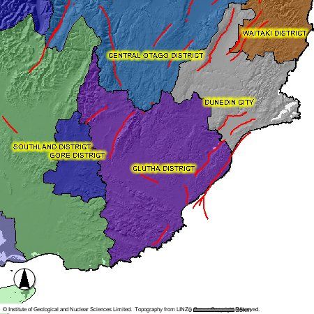
6.3 STRUCTURE AND STAFFING ARRANGEMENTS                              41
        6.3.1 Recovery Management Structure                          41
6.4 RECOVERY PROCESS                                                 42
7 MONITORING AND EVALUATION                                          44
7.1 INTRODUCTION                                                     44
7.2 CDEM PROGRAMME AND TARGETS                                       44

TABLES

Table 1: Context of CDEM Plan provisions                             11
Table 2: Employment and GDP contributions 15                         15
Table 3: Monitoring and alerting agencies 28                         28
Table 4: Levels of emergency 31                                      31
Table 5 Key tasks 45                                                 45

FIGURES

Figure 1: Clutha District Map                                         8
Figure 2: Active fault lines 16                                      16
Figure 3 CIMS structure 32                                           32
Figure 4 Recovery structure 42                                       42

Clutha District Civil Defence Emergency Management Plan, 2012‐2017        Page 3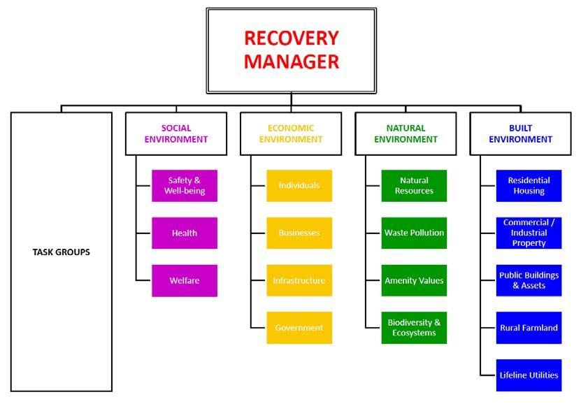
GLOSSARY OF TERMS
Commonly used terms and abbreviations used throughout the Plan include:
4Rs: Four areas of emergency management: Reduction, Readiness, Response and Recovery.
The Act: The Civil Defence Emergency Management Act 2002
CDEM: Civil Defence Emergency Management
CDEM Group: Established under section 12 of the Civil Defence Emergency Management Act
2002. Unless otherwise stated in the Plan, it refers to the Otago CDEM Group, a joint standing
committee with membership comprising the Mayors from the Central Otago District, Clutha
District, Dunedin City, Queenstown Lakes District and Waitaki District Councils and the
Chairperson of the Otago Regional Council.
CEG: Co‐ordinating Executive Group Established under Section 20 of the Act. Functions include
providing advice to the CDEM Group and any sub‐groups of the CDEM Group; co‐ordinating
and overseeing as appropriate the implementation of decisions of the Group by the Group
CDEM Office or by individual members; and overseeing the implementation, development,
maintenance, monitoring and evaluation of this Plan.
CIMS: Co‐ordinated Incident Management System. Establishes a framework to assist in
effective, efficient and consistent response to an incident/emergency management.
Declaration: A Declaration allows the Controller and others access to statutory powers with
the purpose to grant people the necessary authority to protect life and property in
extraordinary emergency events. The rationale for declaring a state of emergency is:
    •   an emergency event has occurred or may occur;
    •   the safety of the public or property is endangered;
    •   loss of life, injury, illness, or distress may be caused; or,
    •   usual services are inadequate to deal with the emergency.
Emergency: As defined under the Act: 1. Is the result of any happening, whether natural or
otherwise, including, without limitation, any explosion, earthquake, eruption, tsunami, land
movement, flood, storm, tornado, cyclone, serious fire, leakage or spillage of any dangerous
gas or substance, technological failure, infestation, plague, epidemic, failure of or disruption to
an emergency service or a lifeline utility, or actual or imminent attack or warlike act; and 2.
Causes or may cause loss of life or injury or illness or distress or in any way endangers the
safety of the public or property in New Zealand or any part of New Zealand and 3. Cannot be
dealt with by emergency services, or otherwise requires a significant and co‐ordinated
response under the Act.
Emergency Services: The New Zealand Police, New Zealand Fire Service, National Rural Fire
Authority, rural fire authorities and hospital and health services.
EOP: Emergency Operating Procedure refers to a document describing a formally established
set of operational procedures that are the commonly accepted method for performing certain
emergency management tasks.
GECC/EOC: Group Emergency Coordination Centre / Emergency Operations Centre.                    An
established facility where the response to an event may be managed and supported.
ICP: Incident Control Point. A facility where site response to an incident is managed and
controlled.

Clutha District Civil Defence Emergency Management Plan, 2012‐2017                          Page 4
Lead Agency: The organisation with the legislative authority; or because of its expertise and resources, agreed authority; primarily responsible for control of an incident Lifeline Utility: An entity named in or described in section 1 of the Act. Within Otago, these include Radio New Zealand, Television New Zealand, airports, port companies, gas, electricity, water, waste water, sewerage, telecommunications, roads, fuel, and rail industries. Local Authority: Means a Regional Council or District/City Council. Other Acronyms include: CDC: Clutha District Council CODC: Central Otago District Council DCC: Dunedin City Council LTP: A Council’s Long Term Plan MCDEM: Ministry of Civil Defence and Emergency Management NZTA: New Zealand Transport Agency ORC: Otago Regional Council QLDC: Queenstown Lakes District Council WDC: Waitaki District Council Clutha District Civil Defence Emergency Management Plan, 2012‐2017 Page 5
1         INTRODUCTION

              This section provides the context and background of the plan including an
              overview of the integrated risk management approach and a picture of the local
              setting. The section also describes the structure and governance of the Otago
              CDEM Group that Clutha District is a part of. At the end of the section there is a
              description of the Clutha District CDEM Work Programme and methods for
              monitoring and evaluating the achievement of CDEM objectives.

1.1        INTRODUCTION
The Clutha District Civil Defence Emergency Management (CDEM) Plan is part of a hierarchy of
Plans which also includes the National CDEM Plan and the Otago Group CDEM Plan. The
purpose of this structure is to enable the effective and efficient management of hazards and
risks within the Clutha District, and to ensure a coordinated approach for hazards and risks
beyond the District.
The Clutha District CDEM Plan sets out the local emergency management activities and
operational arrangements for the district, and aims to:
      •   Increase awareness of the hazards and associated risks in the Clutha District.
      •   Strengthen relationships between agencies involved in CDEM at a local level.
      •   Encourage cooperative planning and action between local emergency services,
          agencies and organisations as well as the community.
      •   Contribute to the Otago CDEM Group Plan by delivering a more coordinated, effective
          and consistent CDEM programme.
      •   Outline the arrangements for the Clutha District using an integrated risk management
          approach addressing Reduction, Readiness, Response and Recovery.
This Plan has been primarily developed for the CDEM and Emergency Services sector, which
will use and be directly affected by the Plan. However, the Plan is also for other individuals and
groups that could at times be involved in CDEM activities, and of course for the general public
who should benefit from the plan.

1.2        BACKGROUND
The CDEM Act 2002 states that local authorities must be a member of a CDEM Group (section
12) and must plan and provide for civil defence emergency management within their district
(section 64). The Clutha District is part of the Otago CDEM Group, and as a member a key
responsibility is the development and implementation of a comprehensive local CDEM Plan,
which is consistent with the Group Plan.
The Plan is NOT the document that CDEM personnel will use to guide their actions during an
emergency. That role will be filled by various local and event‐specific plans and standard
operating procedures. However, this Plan DOES set out the framework that emergency
responses will work under, and will guide the work programmes to ensure that the
information, resources and documentation are there when needed in an emergency.

Clutha District Civil Defence Emergency Management Plan, 2012‐2017                         Page 6
Importantly, the Plan also establishes the relationships that will be called upon when an event
goes beyond the scope or capacity of an individual agency.
This is the second edition of this Clutha District CDEM Plan, and replaces the previous version
(Clutha District Operational Plan 2004). It has been developed in consultation with the CDEM
Group members, CDEM and Emergency Services staff, and other key agencies, and follows a
process of consultation and review.
1.3 INTEGRATED RISK MANAGEMENT
Civil Defence Emergency Management in New Zealand uses an integrated risk management
approach when dealing with hazards. This integrated approach is written into the National
CDEM Framework including the CDEM Act and is described by the four areas of activity, known
as the 4Rs.
• Reduction: Identifying and analysing long‐term risks to human life and property from
hazards; taking steps to eliminate these risks if practicable, or reducing the magnitude
of their impact and the likelihood of their occurring.
• Readiness: Developing operational systems and capabilities before a civil defence
emergency happens; including self‐help and response programmes for the general
public, and specific programmes for emergency services, lifeline utilities and other
agencies.
• Response: Actions taken immediately before, during or after a civil defence emergency
to save lives and protect property, and to help communities recover.
• Recovery: The coordinated efforts and processes to bring about the immediate,
medium‐term and long‐term holistic regeneration of a community following a civil
defence emergency.
1.4 THE LOCAL SETTING
The Clutha District is situated in the southern part of the Otago Region. It covers an area of
approximately 6362 square kilometres, mainly in farmland with a number of townships and
small communities spread throughout the District (see Figure 1: Clutha District map).
The key geographical feature is the Clutha River, which runs through the centre of the District,
and splits into two branches (Koau and Matau) before running into the sea. Other main rivers
are the Pomahaka, which flows into the Clutha River at Clydevale, and the Taieri River, which
forms part of the northern boundary of the District. There are a number of moderate ranges,
but no alpine areas.
1.5 THE OTAGO CDEM GROUP
The Otago CDEM Group is a consortium of local authorities working in partnership with
emergency services and other key stakeholders to deliver CDEM at a regional and local level.
The Otago CDEM Group area consists of the Waitaki District, Dunedin City, Clutha District,
Central Otago District and Queenstown Lakes District.
Clutha District Civil Defence Emergency Management Plan, 2012‐2017 Page 7Figure 1: Clutha District map Clutha District Civil Defence Emergency Management Plan, 2012‐2017 Page 8
JOINT COMMITTEE
The Group is governed by a joint committee set up under section 12 of the CDEM Act, which is
made up of the five local mayors and the Chairperson of the Otago Regional Council (or
persons acting on their behalf). The functions of the Group are detailed in section 17 of the
Act, and include developing, approving, implementing and monitoring a CDEM Plan. The joint
committee has adopted a Group CDEM Plan, which includes Goals and Objectives, information
on each of the Four Rs and governance and management arrangements, and a five‐year work
programme.

COORDINATING EXECUTIVES GROUP (CEG)
The Joint Committee is supported by the Coordinating Executives Group (CEG), made up of the
Chief Executives of the six councils (or persons acting on their behalf), plus senior
representatives from the NZ Police, NZ Fire Service, St John Ambulance, the Southern District
Health Board, and the Ministry of Social Development. The Group Controller and a
representative from MCDEM sit in as observers on the CEG. The CEG is responsible for
implementing the decisions made by the Joint Committee, providing advice to the Group and
overseeing the group’s annual work programme and member contributions. To help with
CDEM planning and to ensure consistency across the group, the CEG has established four
planning committees that are comprised of nominated representatives throughout the Otago
region. These committees are referred to throughout the plan.

GROUP EMERGENCY MANAGEMENT OFFICE
The Group Emergency Management Office is based at the Otago Regional Council and is the
administrative authority for the Otago CDEM Group, Joint Committee and the CEG. It provides
such services as secretariat for CDEM group meetings, accounting for CDEM Group finances
and budgets, publishing of CDEM Group plans and reports as well as entering into contracts on
behalf of the group members. The Group Office also employs an Emergency Management
Coordinator to help facilitate and coordinate the day‐to‐day planning, project work and
activities of the CDEM Group and its members.

LOCAL EMERGENCY MANAGEMENT OFFICES
Each member of the CDEM Group has their own local emergency management office. Local
offices are responsible for delivering CDEM activities within their own area that contribute to
the joint activities of the group. Activities are carried out under the integrated risk
management approach of the 4 R’s and are discussed under each section of this plan. Local
CDEM Offices are responsible for employing their own staff and the number of staff generally
depends on the size of the territorial authority and the type of activities they undertake.

1.6      THE CLUTHA DISTRICT EMERGENCY MANGEMENT OFFICE
The Clutha District Emergency Management Office is managed by Clutha District Council within
the Regulatory Services Department. Council has appointed a full‐time Civil Defence
Emergency Management Officer who reports directly to the Planning and Environment
Manager. However, other staff across the Council also contribute to overall CDEM activities, in
roles including management, planning, communications, infrastructure, and administration.

The role of the Emergency Management Office is focused on building community resilience
through enhancing operational capacity and community readiness to cope with emergencies
as well as coordinating an effective response and ensuring the best possible recovery. The

Clutha District Civil Defence Emergency Management Plan, 2012‐2017                      Page 9
Office achieves this by undertaking a broad range of CDEM reduction and readiness initiatives
including:
    •   Coordinating CDEM planning and activities within the District and with the wider
        Otago Group to address the areas of risk reduction, readiness, response and recovery.

    •   Preparing CDEM plans, policies and procedures.

    •   Maintaining the EOC and related equipment and materials

    •   Preparing and delivering public education programmes.

    •   Training and exercising CDEM staff and volunteers.

    •   Working with other agencies and volunteers involved in emergency management.

    •   Monitoring and responding to hazard advisories, warnings and emergencies that arise.

    •   Contributing to Group activities and functions.

In the event of an emergency the Clutha District Council provides trained staff, facilities and
resources in support of the response, for both the Emergency Operations Centres (Council
head office, Balclutha) and Ward Centres (Service Centres around the District). Key CDEM
appointments are made on the basis of the individual involved rather than being tied to
specific council positions, and include volunteers from outside Council. The Emergency
Management Office maintains a list of people appointed to key CDEM positions (for at least
two shifts) and meets with them regularly.

FINANCIAL ARRANGEMENTS
The Emergency Management Office is funded by the Clutha District Council. The administrative
and day‐to‐day costs incurred as part of the activities and functions the office undertakes to
achieve the objectives outlined within the annual work plan, including for personnel, facilities
and resources, are budgeted for in the Council’s Long Term Plan and Annual Plan. This includes
costs associated with the Clutha District’s contribution to group activities such as
representation on the Joint Committee, CEG and Group Committees.
The costs incurred during and following an emergency will need to be met initially by the
Council but with reimbursement by central government in accordance with national policy. It is
the responsibility of the Council to claim for any reimbursement or financial assistance and a
clear record of expenditure, authorisation and purpose needs to be maintained during the
emergency.
Organisations, agencies and other CDEM stakeholders are responsible for meeting all their
own costs incurred as a result of the emergency whether directly requested by the local
authority or by the CDEM group, unless written authorisation has been granted by the Local
Controller.

WORK PLANS
The Clutha District develops an annual work programme that aligns with the goals and
objectives set by the Group and the local emergency management office. The work
programme is developed prior to July each year, and describes the activities the District is
planning to implement over the coming 12 months – both local activities within the District,
and contributions to wider Group activities.

Clutha District Civil Defence Emergency Management Plan, 2012‐2017                      Page 10
1.7 CONTEXT OF THIS PLAN
The Clutha District Civil Defence Emergency Management Plan is part of a national suite of
plans, including the National CDM Plan, Group Plans (including the Otago CDEM Group Plan),
and local authority plan’s such as this one. This Plan gives effect to the high level plans, as set
out below:
NCDEM goal NCDEM objectives Otago CDEM Group Clutha CDEM Plan
objectives provisions
1 Increasing 1a Increasing the level of 1a Increase the level of Sec 3.2
community community awareness business and Sec 4.2.1
awareness, and understanding of community
understanding, the risks from hazards awareness through
preparedness and 1b Improving individual, public education
participation in community and and consultation.
civil defence business preparedness 1b Improve community Sec 4.2.2
emergency 1c Improving community participation and
management participation in CDEM preparedness
1d Encouraging and through community‐
enabling wider based planning.
community
participation in hazard
risk management
decisions
2 Reducing the risks 2a Improving the co‐ 2a Improve Sec 3.2
from hazards to ordination, promotion understanding of
New Zealand and accessibility of Otago’s hazardscape
CDEM research and associated risks. Sec 3.2
2b Developing a 2b Undertake long‐
comprehensive term, strategic
understanding of New reduction of the
Zealand’s hazardscape risks from hazards
2c Encouraging all CDEM through
stakeholders to reduce collaborative work
the risks from hazards within the group
to acceptable levels and with other
2d Improving the co‐ stakeholders.
ordination of
government policy
relevant to CDEM
Clutha District Civil Defence Emergency Management Plan, 2012‐2017 Page 11NCDEM goal NCDEM objectives Otago CDEM Group Clutha CDEM Plan
objectives provisions
3 Enhancing New 3a Promoting continuing 3a Enhance Sec 4.3.1
Zealand’s and co‐ordinated professional
capability to professional development for all
manage civil development in CDEM emergency
defence 3b Enhancing the ability of management
emergencies CDEM Groups to personnel through
prepare for and training, exercises
manage civil defence and learning from
emergencies other CDEM Groups Sec 4.3.2
3c Enhancing the ability of 3b Strengthen the Sec 4.3.3
emergency services to coordination and
prepare for and cooperation
manage civil defence amongst all relevant
emergencies sectors in planning
3d Enhancing the ability of for and responding
lifeline utilities to to an emergency Sec 4.3.3
prepare for and 3c Develop and
manage civil defence maintain
emergencies appropriate
3e Enhancing the ability of documentation to
government agencies describe key
to prepare for and activities, functional
manage civil defence responses and
emergencies protocols in support Sec 4.4
3f Improving the ability of of the CDEM Group
government to manage Plan
an event of national 3d Provide effective
significance warning systems to
enable agencies and
the community to Sec 4.5
respond rapidly to a
potential event
3e Establish and
maintain effective
and resilient inter‐
agency
communications
systems.
4 Enhancing New 4a Implementing effective 4a Strengthen recovery Sec 6
Zealand’s recovery planning and capability and
capability to activities in capacity across all
recover from civil communities and agencies and the
defence across the social, wider community.
emergencies economic, natural and
built environments
4b Enhancing the ability of
agencies to manage the
recovery process
Table 1: Context of CDEM Plan provisions
Clutha District Civil Defence Emergency Management Plan, 2012‐2017 Page 122 CLUTHA DISTRICT’S RISK PROFILE
The risk profile section provides the risk management context and hazardscape
of Clutha District. It describes and systematically analyses the district’s
environment, the risks associated with hazards, and discusses emergency
management implications relevant to the district.
Knowledge of the District’s vulnerability to hazards is fundamental to guiding the activity and
effort applied to risk reduction, readiness, response and recovery programmes. The
characterisation of the risk environment in this section provides a basis for sound prioritisation
of resources and effort in CDEM planning. It also provides a snapshot in time of the risk profile,
as a baseline for ongoing monitoring and evaluation of risk reduction programmes.
2.1 CLUTHA DISTRICT ENVIRONMENTS
The risk management context for the Clutha District is comprised of the people, the land, the
buildings/infrastructure and the economy, commonly referred to as the social, natural, built
and economic environments. Analysing these elements helps to understand the unique
combination of factors that influence CDEM planning.
2.1.1 S OC I A L E NV I R O N M E N T
POPULATION
The Clutha District has a population of 17,550 (Statistics New Zealand estimate June 2011). The
population is spread across the District, with approximately one‐quarter in the main town of
Balclutha, another quarter in the smaller towns of Milton, Kaitangata, Tapanui, Lawrence,
Owaka, Stirling, Clinton and Kaka Point, and the remainder of the population dispersed among
smaller townships and the rural farming areas.
POPULATION
Within the District’s population, 51% are male and 49% female. The median age within the
District is 38.8 years, slightly older than the national median age of 35.9 years. The proportions
of people aged less than 15 years or older than 65 years are both greater than the national
average, but there is a dip in the age distribution between 20‐29 years old. Key drivers for this
are that young people leave the district for educational or employment opportunities
elsewhere, while older people come to the district from elsewhere for lifestyle and family
reasons.
ETHNICITY
Clutha District has relatively low ethnic diversity, with 80.0% European (compared to 67.6%
nationally), and 9.0% Maori (14.6% nationally).
EMPLOYMENT
The main employment sectors in the District are based on rural activity, with primary
production (dairying, sheep and beef farming, and forestry) the largest sector followed by
manufacturing (meat, dairy and wood processing).
Clutha District Civil Defence Emergency Management Plan, 2012‐2017 Page 132.1.2 BUILT ENVIRONMENT URBAN The Clutha District does not have one main urban centre. The largest town is Balclutha (2011 population estimate 4060), which is also the main servicing centre. However, a further 4,670 people live in the smaller towns of Milton, Kaitangata, Tapanui, Lawrence, Owaka, Clinton, Kaka Point and Taieri Mouth. Those towns all reflect the rural nature of the District, with few large or multistory buildings. ELECTRICITY Electricity is delivered to the Clutha District from the National Grid via a deviation from the 110kV Gore‐Halfway Bush line to the Balclutha substation. There are also three 220kV and two other 110kV lines which pass through the District. There are two 110kV feeds into the District, from Gore and Halfway Bush, both going to the Balclutha Substation. The local distribution network is operated by OtagoNet, with electricity distributed from the Balclutha Substation to local township substations at 33kV, and the distributed to consumers at 11kV. Electricity is generated at two wind farms – Mahinerangi (36MW) and Mount Stewart (7.65MW) – and at various hydro stations on the Waipori Scheme (83MW), and two stations on the Deep Stream Hydro Scheme (5MW). All the electricity generated is supplied into the local distribution network. In total, the District produces sufficient electricity annually to power over 40,000 homes. However, due to industrial demands, generation variability, and the fact that much of the electricity generated goes to Dunedin City, the District is still dependant on importing electricity from the national grid to maintain a consistent supply. TELECOMMUNICATIONS Telecommunications in the Clutha District consist of both fixed line and wireless /cellular communications. Wireless /cellular communications however are still somewhat dependant on the fixed line network and the connections made through a national fibre optic cabling network. Cables come into the district from via two routes – A Telecom New Zealand cable which runs along State Highway 1, and a Telstra Clear cable which runs along the Main Trunk Rail line. Based on the 2006 Census, households in the Clutha District have the same access to telephones as the national average (91%), but lower access to a mobile phone (72% compared to 74% nationally), and internet (53% compared to 60% nationally). The District’s large area and relatively dispersed population means that levels of service vary widely, with some areas having little or no cellphone coverage and limited broadband availability. In recent years cellphone and satellite based communications have become more popular, with some new subdivisions having no landline communications. The Government’s Rural Broadband Initiative will see some new fibre and cellphone installation around the District. However, it appears that this will improve service to areas of existing coverage and then later in the programme, with the only significant new coverage being to Papatowai. TRANSPORT The Clutha District is traversed by three State Highways – SH1 which runs north to south through the District (including Waihola, Milton, Balclutha and Clinton), SH8 which goes inland from Clarksville (3km south of Milton) to Central Otago, and SH90 which connects Gore to Raes Clutha District Civil Defence Emergency Management Plan, 2012‐2017 Page 14
Junction on SH8 via Tapanui. The District also has a very extensive local roading network – at
2916km, the third‐largest in New Zealand. Local roads are a mix of some sealed (27%) and
mostly unsealed (73%). The Main Trunk Rail line runs north‐south through the District.
There are no commercial airports within the District, although there is an aerodrome at
Balclutha and numerous rural airstrips on farms around the District. There is a fishing port at
Taieri Mouth and boat ramps in most coastal communities, but they are suitable for small craft
only.

WATER, WASTEWATER AND STORMWATER
The Clutha District Council operates 23 water supply schemes, including 11 rural schemes, 6
urban schemes, and 6 urban areas supplied from rural schemes. Overall, 30% of the water is
used for domestic consumption, and the remainder for farming purposes. Sewage is
reticulated and treated from most townships (12 in all). The only significant unreticulated
townships in the District are Taieri Mouth, Pounawea, and Papatowai, all small coastal
communities which have neither public water nor sewerage systems.
Stormwater is managed via a range of methods, from simple roadside ditches in rural areas to
major piped schemes in urban areas. In Balclutha, Milton, Stirling and Kaitangata pipes and
floodgates are required to drain stormwater through floodbanks, and in Balclutha and Milton
this is assisted by stormwater pumps during heavy rainfall and or high river events. In many
locations there are connections between District Council urban stormwater schemes and
Otago Regional Council scheduled drains and flood protection works.

2.1.3    E C O N O M I C E N V I R O N M E NT
The Clutha District’s economy is strongly based on the rural sector, especially dairy, sheep and
beef farming, and forestry, along with downstream processing. Clutha’s contribution is
relatively high – despite having only 22% of Otago’s land area, Clutha has 46% of production
dairy cows, 48% of lambs raised and 66% of plantation forest area.
Based on a recent Otago Economic Profile by Business and Economic Research Ltd in 2011
Clutha District’s GDP was $847 million dollars. Primary industry (including agriculture,
horticulture and forestry) and manufacturing are the sectors that make the biggest
contribution to the Clutha District’s economy.

The contribution of the various sectors to GDP and employment is set out below:

                                         GDP (%)              Employment (%)
                Primary Industry         $369m (43.6%)        3,143 (37.5%)
                Manufacturing            $184m (21.8%)        1,728 (20.6%)
                Construction             $32m (3.8%)          475 (5.7%)
                Wholesale/Distribution   $38m (4.5%)          326 (3.9%)
                Retail                   $48m (5.6%)          963 (11.5%)
                Business Services        $95m (11.2%)         364 (4.3%)
                Arts and Recreation      $3m (0.3%)           37 (0.4%)
                Social Services          $78m (9.2%)          1,338 (16.0%)
                TOTAL                    $847m                8,373
                Table 2:        Employment and GDP contributions

Clutha District Civil Defence Emergency Management Plan, 2012‐2017                      Page 15
2.1.4 NA T U R AL E NV I R O N ME NT
The Clutha District is highly developed, being mostly flat to rolling farmland, with forestry
generally on hill country. The main exceptions to this are the Catlins – a coastal area with
significant tracts of indigenous forest in the southern part of the District – and the high ranges
of the Blue Mountains and the Lammerlaw Range.
The District has a number of significant waterways, in particular the Clutha River (New
Zealand’s largest by volume) and the Taieri, Waipori and Pomahaka Rivers, the Lake Waipori –
Waihola wetland complex, and Lake Mahinerangi.
Figure 2: Active Fault Lines
In terms of the underlying geology, the District has a schist bedrock overlain by various
sedimentary layers. The two main faultlines are the Akatore Fault – which runs parallel to the
coast from Taieri Mouth to around Toko Mouth, and the Titri fault which follows a similar
orientation along the eastern side of the Waihola‐Waipori area and the Tokomairiro Plain.
Other known faults include the Castle Hill fault (east side of Clutha delta), Clifton Fault (south
of Clydevale parallel to the Clutha and Pomahaka Rivers), Blue Mountains fault (western side
of the mountain range), the Spylaw fault (Leithen Burn to Heriot), Tuapeka Fault (Beaumont)
and the Settlement Fault (Catlins Lake to Papatowai). Return periods range from 2000 years to
10,000, although some are unknown. For faults where an estimate of likely severity can be
made, they are classified as up to moderate.
The climate of the District is temperate:
Mean annual rainfall 678mm
Mean daily maximum temperature (summer) 19.6 degree
Clutha District Civil Defence Emergency Management Plan, 2012‐2017 Page 16Mean daily maximum temperature (winter) 10.0 degrees
Mean sunshine hours 1631
Mean days with snow lying 1.6
2.2 CLUTHA DISTRICT HAZARDSCAPE
The combination of all hazards within an area is commonly referred to as the hazardscape. The
Clutha District is vulnerable to a wide range of significant hazards including floods,
earthquakes, severe weather, tsunami, storm surge, rural fire, pandemics, infrastructure
failures and industrial or transportation accidents.
Hazards are interactive and can have many effects on the environment. They can also trigger
additional hazards ‐ for example an earthquake can weaken floodbanks, and flooding can lead
to land subsidence. Additional hazards such as these are dealt with as part of the response to
the main primary hazard.
Risks are defined by the likelihood of the hazard occurring and the consequences of the hazard
if it does occur. While evaluating the risk can provide priorities for CDEM planning it doesn’t
determine which disaster will actually occur next. Hazards in this plan are therefore assessed
individually based on their own likelihood of occurring and their own consequences. The main
hazards considered relevant to the Clutha District are:
• Floods occur when the amount of water in a river exceeds the capacity of the river
channel and inundates adjacent land. Flooding is relatively frequent in the Clutha
District, and is the most common cause of a CDEM response. In most cases flooding
which causes damage is the result of local rainfall, with the areas most frequently
affected being Milton, West Otago and the Catlins. However, there is also the potential
for flooding as a result of inland rainfall raising the level of the Clutha River, which can
threaten Clydevale, Balclutha, Stirling, Kaitangata, Inchclutha and the Clutha Delta.
• Earthquakes are caused by the sudden release of accumulated strain along a fault.
Although the Clutha District has relatively low direct risk compared to other parts of
New Zealand, it could be affected by small‐moderate earthquakes on faults within the
District or as a result of moderate to large earthquakes on the Alpine Fault. A
damaging earthquake could occur at any time, without warning, and can be followed
by aftershocks that continue for days, weeks or months.
• Severe Weather which can affect the District includes heavy rainfall, strong winds,
heavy frosts and snowstorms. These events can generally be predicted and weather
forecasts allow time to prepare for a potential disaster, but if the damage is severe or
the event continues for some days then there can be significant impacts.
• Tsunami is a constant risk due to New Zealand’s location on the Pacific “Ring of Fire”.
Warning times and impacts depend on the location of the earthquake or undersea
landslide which triggers the tsunami. The greatest risks are from South American
events (which could generate a multi‐metre tsunami with around 12 hours warning
time), and from the Puysegur Trench off Fiordland (which could also generate a multi‐
metre tsunami but with only 1‐2 hours warning). Events in the mid Pacific are less of a
threat as the District is shielded by the rest of New Zealand. The Otago Regional
Council has published a 2012 report “Community vulnerability to elevated sea level
and coastal tsunami events in Otago” which gives detailed information on the risks and
vulnerabilities.
Clutha District Civil Defence Emergency Management Plan, 2012‐2017 Page 17• Storm surge is a rise in sea level due to extreme low pressure systems during a storm.
By its very nature, it often occurs together with flooding and strong winds. The Otago
Regional Council report “Community vulnerability to elevated sea level and coastal
tsunami events in Otago” mentioned above also gives detailed information on the risks
and vulnerabilities to storm surge.
• Rural Fires are defined as any unexpected fire in an open space, such as a gorse‐
covered hillside, grassland or forest. A rural fire hazard is created when fire threatens
lives, properties, commercial plantations or areas of natural or cultural significance.
Clutha District is moderately susceptible to rural fire hazards due to the potential for
warm gusty, nor‐westerly winds and the substantial amount of forested land. In
general, rural fires are dealt with by the Clutha District Council in its role as Rural Fire
Authority, but in a large event or one which threatened a township there could be a
need for CDEM support.
• Pandemics are characterised by the global spread of a virulent pathogen that can
cause unusually high rates of illness and mortality for an extended period of time. A
pandemic can overwhelm the resources of a society due to the exceptional number of
people affected. The Clutha District has some advantages in being geographically
isolated with relatively low population density. However if a pandemic were to arise
within the district the effects could be significant. A pandemic is likely to affect the
ability of society and the economy to function normally, and can indirectly lead to a
subsequent deterioration of infrastructure services through high absentee rates in the
workforce as people fall ill or stay at home to care for the sick.
• Infrastructure Failures are caused by external factors such as natural hazards or
terrorism or internal causes such as lack of maintenance or planning. Clutha District
like the rest of New Zealand is highly reliant on its infrastructure: electricity,
telecommunications, water services and transportation networks. The more reliant
people are on infrastructure, the more vulnerable they are to infrastructure failure.
While a single infrastructure failure can be a significant event, the disruption from
multiple infrastructure services is potentially very severe. For example,
telecommunications supply and water services depend on electricity. Thus if electricity
is disrupted to the District the effect could potentially be disastrous to peoples way of
life.
2.3 IMPLICATIONS FOR CLUTHA DISTRICT CDEM
Based on the Clutha District’s environments and hazardscape as outlined above, there are a
number of implications for Civil Defence Emergency Management in the District:
• The District has a relatively dispersed population. While this is positive in that there is
less chance that a large number of people will be impacted by any single event, it also
poses a challenge by making it more difficult to coordinate and concentrate CDEM
effort.
• The importance of primary production and processing to the District means that it is
particularly vulnerable to events that disrupt these sectors such as flooding and
snowfall.
• The large number of dairy farms means that many workers and their families arrive in
the District for short periods of time, making it more difficult to ensure that they are
well‐informed about CDEM risks and activities.
Clutha District Civil Defence Emergency Management Plan, 2012‐2017 Page 18• In some communities, especially coastal townships and Lawrence, the high proportion
of tourists and holiday home owners can create particular issues for CDEM. They
cannot be informed and advised regarding emergency preparedness in the same way
as the resident population, and they can have very different needs during and after an
event placing added pressure on resources.
• Groups that have been identified as particularly vulnerable in a CDEM emergency
include those aged over 65 and under 15 years, which are both relatively over‐
represented in the District.
• Some areas within the District, particularly those away from the main centres such as
the Catlins and West Otago have little or no cellphone coverage and limited
broadband availability, which has wide‐ranging emergency implications.
• Transportation within the district is limited almost entirely to roads, with very limited
capacity for airplanes or boats. This means that there is a huge dependency on the
roading network to be functioning in an emergency, not only for residents but for
emergency services and the transportation of other goods and services such as fuel.
While helicopters are available and potentially very useful, in a large‐scale event they
are likely to be in high demand.
• Water and wastewater services for much of the population are dependent on the
operation of a large number of reticulated systems. As with the dispersed population
this has both advantages and disadvantages, with it being less likely that one event will
affect a large number of schemes, but more difficult to manage resilience and
response across all the schemes.
• The frequency of flooding means that the District’s CDEM structures and general
population are relatively well‐prepared to deal with these events. However, this also
means that there is a relatively lower level of preparedness for sudden impact events
such as earthquakes.
Clutha District Civil Defence Emergency Management Plan, 2012‐2017 Page 193 REDUCTION
This section provides an overview of the initiatives used to reduce the risks in the
Clutha District. It describes the principles of reduction and explains the activities
used to achieve CDEM objectives including CDEM research, lifelines resilience,
plans and policies, and reduction planning.
3.1 INTRODUCTION
Reduction involves identifying and analysing long‐term risks to human life and property from
natural or man‐made hazards; taking steps to eliminate these risks if practicable and, if not,
reducing the magnitude of their impact and the likelihood of them occurring.
Risk reduction is achieved through integrated risk management and methods such as hazard
mapping and monitoring, land‐use planning, improved building design and construction,
physical mitigation works, public awareness and education, sustainable land management,
regulation and monitoring, upgrading infrastructure resilience and emergency management
planning.
Risk reduction involves many stakeholders including central government, local authorities,
emergency services and lifeline utilities, as well as individuals and communities. It is also
guided by many pieces of legislation, policies and plans, both at local and national levels.
Therefore successful, comprehensive risk reduction requires a collaborative, multi‐agency and
all of government approach.
Past risk reduction efforts in the Clutha District have included flood mitigation works such as
stop banks in Balclutha and Kaitangata and flood pumps at Milton, hazard mapping, land‐use
planning (eg the Milton 2060 project to reduce vulnerability to flooding in the Tokomairiro
Plain) and the incorporation of national building codes into local policy which address the risks
associated with earthquakes, floods and severe weather. In addition, individual agencies such
as lifeline utilities continually design and upgrade their networks and procedures to have
resilience to hazards.
Reduction has been identified by the Clutha District Council as a key area for further work in
the term of this Plan.
REDUCTION PRINCIPLES
Reduction principles help to clarify, guide and prioritise reduction activities that all contribute
towards increasing community resilience. There are three reduction principles for the Clutha
District, based on the Otago Group principles, which are:
• To identify and co‐ordinate reduction activities among key stakeholders and the
community.
• To prioritise reduction activities taking into account the impact on human life and
safety, the economy and the built and natural environment as well as the
manageability of the risk and the likelihood of it occurring.
• To develop practical, achievable objectives and methodologies to reduce risk in the
District.
Clutha District Civil Defence Emergency Management Plan, 2012‐2017 Page 203.2 REDUCTION ACTIVITIES
Risk reduction is unlike the other ‘4 Rs’ areas, as much or most of the required activity sits
outside the scope of CDEM structures, and often also outside the wider functions of councils
and other emergency management agencies. It also often has a high cost compared with other
elements of CDEM – it can involve costly infrastructure programmes that can be difficult to
justify economically, especially when compared to other activities with more immediate and
tangible outcomes. It can also involve planning controls under the Resource Management Act,
which place restrictions and impose costs on private landowners.
Reduction activities in the Clutha District fall into two key areas – improving understanding of
hazards and risks, and undertaking work to reduce those risks.
IMPROVING UNDERSTANDING
A fundamental part of reducing risk is to first understand what the risks are. Our current
understanding of the District’s hazardscape has been outlined in Section 2.
Recent work to improve understanding has included an assessment of the vulnerability of
coastal Otago communities to storm surge and tsunami hazard, and investigation of the hazard
associated with flood events in Milton and the Tokomairiro Plain.
Future work within the term of this Plan includes:
• Use and promotion of the Otago Natural Hazards Database (NHDB) which is being
developed by the Otago Regional Council. The NHDB will provide ready access to
hazard information, and so will allow better analysis of risks within the Clutha District,
and the provision of better information to other agencies and the general public.
• An investigation into the vulnerability of the Clutha Delta to natural hazards, including
the effects of predicted changes in climate, in order to assist long‐term sustainable
occupation and land use in this area.
• Consideration of new information and understanding arising from investigations into
the Canterbury Earthquakes. This will include a review of Council’s Policy on
Earthquake‐Prone buildings, which will be done in collaboration with the other
councils in Otago.
RISK REDUCTION ACTIVITIES
The recent MCDEM Monitoring and Evaluation exercise identified that Risk Reduction was an
area of relatively low effort, both within the Clutha District and across the Otago Group as a
whole. Most of the major risks occur across more than one Council area, so it will be more
efficient and effective if reduction activities are coordinated with other Councils. Also, as risk
reduction involves agencies and infrastructure outside of CDEM structures and Council, much
of activity will need to involve collaboration with a range of other organisations (eg scientific
agencies, infrastructure operators, network utilities). Overall leadership of this is intended to
come from the Otago Group (as set out in the Otago CDEM Group Plan). Responsibility for
specific actions will then sit with the various organisations (individually and in collaboration),
with the Risk Reduction Committee coordinating and monitoring this work and reporting back
to the CEG.
Specific activities involving the Clutha District include:
• Consultation with coastal communities to consider and address the implications of the
Otago Regional Council’s 2012 report “Community vulnerability to elevated sea level
and coastal tsunami events in Otago”. This is likely to involve provision of information
Clutha District Civil Defence Emergency Management Plan, 2012‐2017 Page 21to residents, protection of critical infrastructure, preparation of warning systems, and
community‐specific response planning.
• Development and adoption of District Plan provisions for Milton and the Tokomairiro
Plains as a result of the Milton 2060 investigations. This will include new land use
controls for affected areas. As well as the District Plan review, there is also a need to
provide information and improve community preparedness.
• Review of the more general provisions of the District Plan relating to natural hazards.
• Utilisation of the Otago Natural Hazards Database.
• Response to the Clutha Delta vulnerability investigation.
• Upgrades to Council infrastructure to reduce vulnerability to hazards. This includes:
completing additional water reservoir tanks in Tapanui, Lawrence, Balclutha, and
Milton; providing for alternative water supply across Balclutha Bridge via fire hose;
purchasing and installing generators to provide alternative electricity supply for critical
infrastructure such as water treatment plants and community halls; and the ongoing
maintenance and upgrading of water, sewer and stormwater systems to improve
functioning and resilience.
• An area of significant concern is the maintenance of critical points on the roading
network, especially bridges, as NZTA funding has been reduced and it is likely that
Council’s levels of service for roading will reduce as a result. Of particular concern is
the Clydevale bridge over the Clutha River, which is already subject to operating
restrictions.
• Contribution to the Group Reduction Committee, which is coordinating work on
shared infrastructure such as electricity distribution networks and
telecommunications.
Clutha District Civil Defence Emergency Management Plan, 2012‐2017 Page 224 READINESS
The readiness section provides an overview of the initiatives used to prepare the
Clutha District for an emergency. It describes the principles of readiness and
explains the activities used to achieve CDEM objectives including public
education, community planning, business continuity planning, coordinated
incident management, professional development, training and exercises,
operational planning and readiness planning.
4.1 INTRODUCTION
Readiness involves developing operational systems and capabilities before a civil defence
emergency happens, including self‐help and response programmes for the general public, and
specific programmes for emergency services, lifeline utilities and other agencies. Readiness can
be divided into two distinct but related aspects:
• Community readiness focuses on the ability of communities, private businesses,
families and individuals to be able to meet their own needs during and after an
emergency.
• Organisational readiness focuses on the readiness of emergency services, local
authorities, large non‐government organisations and other CDEM stakeholders to be
able to meet not only their own needs during an emergency but also the needs of their
community.
The purpose of the readiness section is to provide an overview of current levels of readiness
and to provide assurance that the Clutha District has the capacity and capability to respond to
and recover from a civil defence emergency. The section also identifies readiness issues and
priorities which the District needs to focus on.
READINESS PRINCIPLES
Readiness principles help to clarify, guide and prioritise readiness activities that contribute
towards increasing community resilience. The readiness principles for the Clutha District are:
• Communities, private businesses, families and individuals have the responsibility to
meet their own needs during and after an emergency.
• Risk management should form part of normal business operations and planning should
include both business continuity and emergency management arrangements.
• Successful emergency management is reliant on good planning activities and
preparedness arrangements with involvement from all stakeholders including the
public.
• The Clutha District Council will at all times maintain an appropriate level of readiness
by monitoring actual and potential events and being able to provide support when
required.
PRIORITIES
As part of the preparation of the Otago CDEM Group Plan, a risk prioritisation model was used
to identify priorities for readiness improvements in relation to specific hazards. It found that
Clutha District Civil Defence Emergency Management Plan, 2012‐2017 Page 23the most difficult hazards to ‘be ready for’ are those that have little or no warning time and
that have very long return periods such as earthquakes and local source tsunamis. The high
priority hazards that had the most effort applied to warning systems and community readiness
were floods, storms, human pandemic and regional/distal tsunami. Overall, the Group area
was assessed as being least ready for earthquake, dam failure and local tsunami; and most
ready for flooding, pandemic, and regional / distal tsunami.
Within the Clutha District a similar situation applies. The District is relatively well‐prepared for
flooding, pandemic, and regional / distal tsunami. These are events which the District has
experience in preparing for and responding to, and involve a moderate amount of advance
warning. The District is least prepared for earthquake and local tsunami, as there have been no
actual events in recent decades and there is little or no advance warning. While there is a
residual risk from dam failure, any flood flows from a dam breach in the Clutha River would
have attenuated by the time they reach the District and so could be handled within normal
flood response protocols.
4.2 COMMUNITY READINESS ACTIVITIES
4.2.1 AW A RE N E S S A ND P R E P A R E DN E S S
All individuals and communities need to be aware of hazards and risks, and how to prepare for
and cope in an emergency. The National Public Education Programme (2006‐2016) provides
the overall direction for developing and delivering public education while local and regional
strategies offer specific advice about local hazards, risks and preparedness steps.
The Otago CDEM Group has identified public education as the foundation for improving levels
of community resilience, and has developed a Public Education Strategy. Activities within the
Clutha District will fit within, and contribute to, that Strategy.
Specific activities include:
• Contributing to Group and National education programmes (eg “What’s the Plan Stan”
and “Turtle Safe”), and delivering them within the District.
• Providing information through Council newsletters, website and other publications.
• Targeted advertising campaigns, generally either in conjunction with a Group or
National campaign, or in response to specific local events and issues.
• Visits to schools, businesses and community groups.
• Provision of information displays and material for relevant events and functions.
4.2.2 C O M MU N I T Y P A RT I CI P ATI O N
Communities in the Clutha District can be isolated during an emergency event, and even when
they are not isolated there may be delays in outside resources being available to assist. This
makes it imperative that communities can survive with little or no outside assistance,
particularly during the early stages of a response. Council is working to address these issues by
working with local communities.
Specific activities include:
• Meeting with key community groups at least once per year.
Clutha District Civil Defence Emergency Management Plan, 2012‐2017 Page 24• Maintaining CDEM Ward Centres at Tapanui, Lawrence, Milton and Owaka, and setting
up new Ward Centres in Kaitangata and Balclutha.
• Contributing to two‐monthly meetings of the Clutha District Emergency Services Trust.
• Working with communities to develop specific responses to their hazards and risks.
This will include all coastal communities covered by the Otago Regional Council’s 2012
report “Community vulnerability to elevated sea level and coastal tsunami events in
Otago”, and a fire evacuation plan for the Tahakopa Valley.
• Promotion and sale of “Grab and Go” bags for personal preparedness.
4.3 ORGANISATIONAL READINESS
4.3.1 ST AFF C AP A CIT Y AN D C A P AB ILI TY
Professional development is a core component of all readiness activities. Appropriate
performance during an emergency can often be attributed to strong working relationships
being established and exercised prior to emergency events.
Specific activities include:
• Specific training for key EOC positions. For some positions this training is available
nationally (Controllers, Public Information Managers and Recovery Managers), and all
people identified for those roles will undertake that training as part of preparing for
the role. For other roles, training will be conducted either in‐house or in conjunction
with the Otago Group, so as to have at least two shifts of trained personnel for all key
positions.
• Monthly meetings of key CDEM staff from within the Council, and twice‐yearly
meetings of all key positions, to ensure all personnel are kept up to date.
• Further training and exercises will be undertaken in collaboration with the Otago
Group, to help ensure that professional development is locally relevant and cost‐
effective, while also improving cooperation and interoperability by having staff from
various agencies working together.
• Contribute to development and implementation of a Group professional development
strategy and training programme.
4.3.2 OPE R ATI O NA L PL AN NI N G GR OU P S
Emergency management operational planning covers a wide range of activities and a number
of emergencies that are extremely varied in duration, frequency, intensity, nature and
consequences. Integrated and coordinated planning facilitates consideration of all the
consequences of the threat or impact of an emergency event on a community. In addition to
the planning undertaken by the Otago CDEM Group and Clutha District Council, there are a
number of other groups and structures that contribute to operational planning (eg Emergency
Services Coordinating Committees, Hazardous Substances Technical Liaison Committee, Rural
Fire Authorities, and the Group Welfare Advisory Committee).
Council will continue to be part of the Clutha Emergency Services Trust, and will contribute to
or work with other groups as required.
Clutha District Civil Defence Emergency Management Plan, 2012‐2017 Page 25You can also read