City of Scotts Valley Active Transportation Plan - Accepted by the Scotts Valley City Council on March 17th, 2021 Funding provided by: Ecology ...
←
→
Page content transcription
If your browser does not render page correctly, please read the page content below

City of Scotts Valley
            Active Transportation Plan
            Accepted by the Scotts Valley City Council on March 17th, 2021

Funding provided by:                          In partnership with: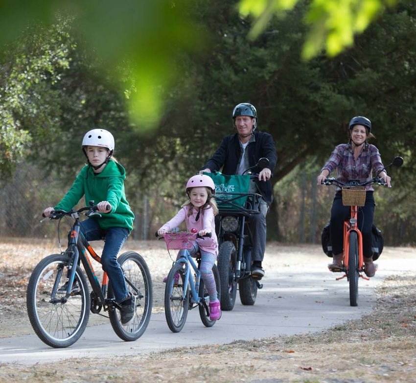
Acknowledgements

Elected Officials                                                  Community Stakeholders
                                                                   Andrew Cavaletto, Scotts Valley Cycle Sport
Derek Timm, Mayor
                                                                   Betty Johansen, Resident
Jim Reed, Vice Mayor
                                                                   Brad Cramer, Resident
Donna Lind, Councilmember
                                                                   Brianna Goodman, Santa Cruz County Regional Transpor-
Jack Dilles, Councilmember
                                                                   tation Commission (SCCRTC)
Randy Johnson, Councilmember
                                                                   Brittany Cavaletto, Scotts Valley Cycle Sport
                                                                   David Stihler, Resident
                                                                   Deborah Benham, SCCRTC Elderly and Disabled Transpor-
                                                                   tation Advisory Committee
City of Scotts Valley
Daryl Jordan, Director of Public Works                             Henrik Ingesson, Resident

Athena Cheung, Engineering Associate                               Ilo Nilson, Resident
                                                                   Jack Dilles, Scotts Valley City Councilmember
                                                                   John Chard, Resident
Project Funding Partner                                            Mark Davidson, Resident
California Department of Transportation
                                                                   Martin Spierings, Resident
Gustavo Alfaro Jr., Caltrans District 5 Division of Planning
                                                                   Matt De Young, Mountain Bikers of Santa Cruz
                                                                   Molly Abroms, Scotts Valley High School
Partner Agencies                                                   Richard Masoner, SCCTRC Bicycle Advisory Committee
Ecology Action                                                     Sergeant John Wilson, Scotts Valley Police Department
Amelia Conlen, Planner
                                                                   Skylar Kuo, Scotts Valley High School
Alejandra Belalcazar, Outreach Specialist
                                                                   Steve Simonovich, Resident
Bike Santa Cruz County
Gina Cole, Executive Director

TJKM Consultant Team
Colin Burgett, Senior Project Manager
Dhawal Kataria, Assistant Transportation Planner

                                         Scotts Valley Active Transportation Plan
                                                               2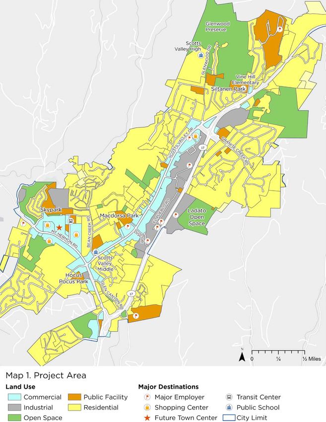
Table of Contents
CHAPTER 1: INTRODUCTION AND BACKGROUND................................................................. 04
CHAPTER 2: EXISTING CONDITIONS....................................................................................... 06
CHAPTER 3: OUTREACH........................................................................................................... 26
CHAPTER 4: PEDESTRIAN AND BICYCLE PLAN.................................................................. 30
CHAPTER 5: IMPLEMENTATION AND MAINTENANCE........................................................... 61

APPENDIX A - PRIORITIZED PROJECT LIST............................................................................. 70
APPENDIX B - SURVEY RESULTS.............................................................................................. 73
APPENDIX C - OUTREACH MATERIALS................................................................................... 76

                                                        Scotts Valley Active Transportation Plan
                                                                                     3
Chapter 1: Introduction and Background
The vision of the Scotts Valley Active Transportation
Plan is to create community connections via active
                                                                  Plan Contents
                                                                  Chapter 1: Introduction and Background. The first chapter
transportation routes that are safe, enjoyable, acces-
                                                                  describes the vision and purpose of the Plan as well as
sible, and well-maintained. The Plan provides recom-
                                                                  the Plan’s relationship to other Scotts Valley planning
mendations for infrastructure projects and programs
                                                                  efforts.
that support walking and bicycling and identifies
possible funding sources and implementation priorities.           Chapter 2: Existing Conditions. This chapter outlines
Implementation of the recommendations included                    current conditions in the City of Scotts Valley, including
in this Plan can help support a healthy community,                land use, commute trends, existing bicycle and pedestrian
improve transportation options for low-income and                 facilities, current programs, and collision data.
vulnerable residents, and help achieve statewide goals            Chapter 3: Outreach. The third chapter describes the
to address climate change by reducing vehicle miles               outreach process and outlines key themes that emerged
traveled.                                                         during public outreach.
Interest in walking and biking for daily trips is growing         Chapter 4: Pedestrian and Bicycle Plan. This chapter
among Scotts Valley residents and employees. Some                 includes goals and policies related to walking and bicy-
students walk, bike, or skateboard to get to school.              cling in Scotts Valley as well as recommendations for
Scotts Valley is a destination for recreational bike trips,       infrastructure improvements and programs to improve
both for road biking and on the Glenwood Preserve                 safety and comfort for people who are walking and biking.
mountain bike trails. Some residents walk or bike to
                                                                  Chapter 5: Implementation and Maintenance. The final
work, and some use active transportation for daily
                                                                  chapter discusses opportunities to fund and construct
errands or trips to the park or the library.
                                                                  the recommended projects and programs and provides
Public input was the foundation of the planning process           a prioritized project list. It also includes a list of funding
to identify transportation needs and opportunities in             sources that the City of Scotts Valley can use to finance
Scotts Valley. The recommendations within this Active             the recommended projects and programs and the
Transportation Plan were developed through engage-                methods the City will use to report on the Plan’s progress
ment with Scotts Valley residents and stakeholders                to the community and to maintain existing and future
as well as an analysis of walking and biking needs                pedestrian and bicycle infrastructure.
throughout the city.
This Plan was funded through a Sustainable Communi-
ties Transportation Planning Grant from the California
Department of Transportation (Caltrans) as well as
local matching funds, and it aligns with the regional and
statewide plans and concepts that are included in the
Caltrans District 5 Active Transportation Plan. Some of
the recommended improvement opportunities are with-
in Caltrans’ right of way, and as the owner and operator
of the State Highway System, Caltrans will require fur-
ther analysis of these planning-level concepts and final
approval if local agencies seek implementation.

                                           Scotts Valley Active Transportation Plan
                                                              4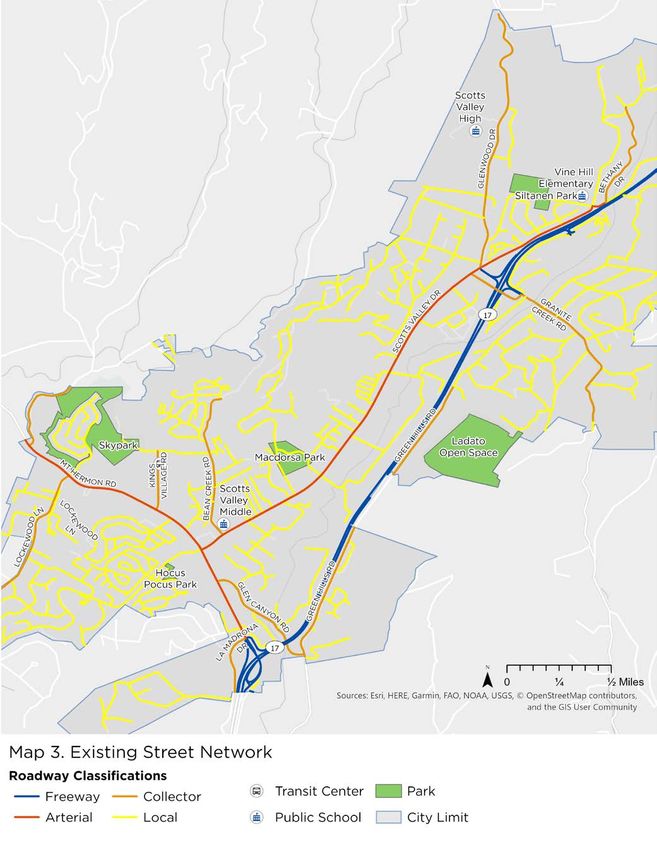
What’s New in this Plan?
This Plan updates the 2012 Scotts Valley Bicycle Transportation Plan and
is the first plan for future pedestrian facilities in Scotts Valley. Over the past    Vision Zero
eight years, bicycle and pedestrian planning has evolved based on new                 Vision Zero is a strategy to eliminate
strategies, research, and designs. In Santa Cruz County and globally, cities          traffic injuries and fatalities while
and counties are adopting Vision Zero policies that seek to eliminate traffic         increasing safe, healthy, and equitable
injuries and fatalities and promote the use of active and shared modes of             mobility, and it has been implement-
transportation. There has also been a growing focus on Complete Streets,              ed in cities around the world. Vision
which are designed to be comfortable and safe for people of all ages and              Zero starts with the belief that traffic
abilities, whether they are walking, bicycling, or driving. Innovations in bicycle    deaths are preventable and brings
infrastructure design have been approved by Caltrans and the National Asso-           together traffic engineers, policymak-
ciation of City Transportation Officials (NACTO) and implemented through-             ers, and public health professionals to
out the state, and the Federal Highway Administration (FHWA) conducts                 work toward solutions. In Santa Cruz
ongoing research on treatments to improve pedestrian and bicyclist safety.            County, Vision Zero is led by County
                                                                                      Public Health, which has assisted the
The recommendations in this Plan were designed with Complete Streets                  cities of Watsonville and Santa Cruz in
principles in mind to support community members as they use active                    passing Vision Zero resolutions.
transportation for their daily trips.

Relationship to Other Plans
The Scotts Valley General Plan guides the physical development of the city,
including changes to the transportation system and built environment. The General Plan envisions a transportation sys-
tem that “enhances residents’ quality of life, supports a vibrant local economy, and promotes environmental sustainability
goals”. To support that vision, the General Plan outlines goals, policies, and actions, including the following goals related
to active transportation:
    » Goal M-1: P
                 rovide a balanced, multi-modal transportation system that is well integrated, efficiently designed, and
                enhances mobility in a sustainable manner.
    » Goal M-2: P
                 rovide “complete streets” that serve all modes of transportation, including vehicles, public transit,
                bicyclists, and pedestrians.
    » Goal M-3: Provide a roadway system that enhances mobility and protects residential neighborhoods.
    » Goal M-4: Provide a roadway system that enhances community aesthetics and promotes a high quality of life.
    » Goal M-5: Improve and expand public transportation services for residents, workers, and visitors.
    » Goal M-6: Provide a complete network of bikeways and bicycle facilities in Scotts Valley.
    » Goal M-7: Provide high-quality pedestrian facilities that support walking and the enjoyment of the outdoors in
                 Scotts Valley.
The Active Transportation Plan helps the City to realize these goals by outlining projects and programs to improve safety,
expand the network of bicycle and pedestrian facilities, and encourage walking and bicycling in Scotts Valley. Additional
goals, policies, and actions related to active transportation are included in Chapter 4.
The County of Santa Cruz/City of Scotts Valley Complete Streets to Schools Plan was completed in February 2020 and
includes infrastructure and program recommendations for the three public schools in Scotts Valley. This Active Transpor-
tation Plan includes the infrastructure recommendations from the Complete Streets to Schools Plan that are located on
city streets in order to create a comprehensive list of city-wide bicycle and pedestrian projects and simplify future project
implementation.
In addition, the 2008 Town Center Specific Plan and 1996 Parks Master Plan were reviewed, and any applicable bicycle
and pedestrian projects are included in this Active Transportation Plan.

                                           Scotts Valley Active Transportation Plan
                                                                  5
Chapter 2: Existing Conditions
Demographics
The City of Scotts Valley is home to an estimated 11,900 residents¹ and 4,364 households² per 2018 Census data.
The median age of the residents is 40.3, which is slightly higher than the median age for Santa Cruz County as a
whole. 22% of Scotts Valley residents are under 18, and 16% are over the age of 65.¹
Among Scotts Valley residents, 77.6% identify as white, 11% identify as Hispanic or Latino, and 7% identify as
Asian.³ The majority of residents have at least some higher education experience, and 55% have either a bachelor’s
or graduate degree.³

Commute Trends
An estimated 5,793 Scotts Valley residents are employed, and more than three-quarters of them drive alone to work.4
This is likely in part because of the proximity of high-paying jobs in Silicon Valley and the Monterey Bay region, which
are located at least six miles from Scotts Valley and are more difficult to reach through active transportation. Scotts
                                     Valley has higher rates of driving alone to work than Santa Cruz County as a whole
                                     and lower rates of walking, biking, carpooling, and public transportation use. Scotts
                                     Valley does have a higher rate of employees working from home than the County,
                                     which reduces the overall number of commute trips.4
                                            The average commute time to and from places of employment for Scotts Valley
                                            residents is 29 minutes. More than half of Scotts Valley commuters have travel
                                            times that are longer than 20 minutes, and 29% of commuters travel for 45 min-
                                            utes or more.4 Several Bay Area companies offer private bus transportation from
                                            Scotts Valley to their Silicon Valley offices, and the Highway 17 METRO bus route
                                            also connects Scotts Valley with Silicon Valley and Santa Cruz. These services
Most City residents can                     provide an alternative to driving alone for longer commute trips.
travel less than two                        While commute trips offer the best data available on travel modes, they represent
miles to visit a grocery                    only a percentage of total trips. Data on the percentage of Scotts Valley residents
store or other common                       walking or bicycling for other daily trips is not available. Scotts Valley’s small size
                                            means that most City residents can travel less than two miles to visit a grocery
destinations. If infra-
                                            store or other common destinations. If infrastructure is provided, these short trips
structure is provided,                      can be easy to do via active transportation and provide the opportunity to increase
these short trips can                       walking and biking trips.
be easy to do via ac-
                                 School trips in Scotts Valley are also significant, with nearly 2,000 students at-
tive transportation and          tending public schools within the city. Parent survey data from 2018 indicated that
provide the opportunity          more than 60% of students at Scotts Valley Middle School and Vine Hill Elemen-
to increase walking and          tary traveled less than two miles to school. Among Scotts Valley High students,
biking trips.                    43% traveled less than two miles. These short commute distances also provide
                                 opportunities for more walking and biking trips. Parent survey data indicated that,
in 2018, 32% of Scotts Valley Middle School students and 19% of Vine Hill Elementary students walked or biked to
school, with that number dropping to 11% of high school students using active transportation.

1. Census American Community Survey 2014–2018 Age & Sex, Table SO101.
2. Census American Community Survey 2014–2018 Households and Families, Table S1101.
3. Census American Community Survey 2014–2018 Selected Characteristics of US Populations, Table SO601.
4. Census American Community Survey 2014–2018 Commuting Characteristics by Sex, Table SO801.

                                                     Scotts Valley Active Transportation Plan
                                                                                6
Figure 1. Work Commute Travel Modes in Scotts Valley
                                                  Commute Travel Modes in Scotts Valley

                    Worked at Home                      7.9%

                                 Other         1.6%

                                Bicycle        0.4%

                               Walked            3.2%

               Public Transportation            2.0%

                            Carpooled                  7.7%

                                                                                                           Drove alone
                         Drove alone
                                                                                                             77.2%

                                          0%          10%      20%     30%       40%   50%     60%   70%   80%     90%

Land Use and Major Destinations
Scotts Valley is located in the Santa Cruz Mountains and covers approximately 4.6 square miles. The majority of land
in Scotts Valley is designated for residential uses. The City enjoys a wealth of parks and open space, with 14% of
land designated as green space. 7% of the City is designated for industrial uses and 4% is designated for commercial
uses, including parking lots.
Major destinations in Scotts Valley include the three public schools, the parks, and the restaurants, markets, and
shopping centers along Mount Hermon Road and Scotts Valley Drive. The area around Kings Village Road is a major
destination and is home to Skypark, the Scotts Valley Library, the Cavallaro Transit Center, the post office, the senior
center, and the community center. The area between Mount Hermon Road, Kings Village Road, the Scotts Valley
Square Shopping Center, and Skypark is also the site of the future Town Center project, which is envisioned as a
mixed-use development that will serve as the city center. If constructed, the Town Center project would become a
major destination within Scott Valley.
Scotts Valley is home to nearly 5,000 jobs,5 and large employers in Scotts Valley also serve as destinations. Five of
the top ten employers in Scotts Valley are located on or near Disc Drive, El Pueblo Road, and Green Hills Road.
As future development occurs in Scotts Valley, this Active Transportation Plan provides a list of projects that can be
used to mitigate development impacts by reducing vehicle miles traveled. In 2013, the state of California approved
Senate Bill 743, which mandates that jurisdictions can no longer use traffic congestion as a metric in transportation
analysis under the California Environmental Quality Act (CEQA). The state released guidelines in 2018 that recom-
mend the use of vehicle miles traveled as the key metric for analyzing traffic impacts. The Active Transportation Plan
is a resource that the city and developers can use as a source for project ideas to improve biking and walking facili-
ties and reduce vehicle miles traveled.

5. Scotts Valley Finance Department, 2019.

                                                         Scotts Valley Active Transportation Plan
                                                                             7
Scotts Valley Active Transportation Plan
                   8
Transit
Scotts Valley is served by three Santa Cruz METRO bus routes. Two of the routes connect Scotts Valley with the City of
Santa Cruz and the San Lorenzo Valley. The third route, the Highway 17 Express, connects downtown Santa Cruz and
Scotts Valley with the Diridon Caltrain station and downtown San Jose. The Cavallaro Transit Center serves as the main
bus transfer point in Scotts Valley and provides all-day parking for those using transit for their daily commutes.
Private bus transportation also connects Scotts Valley with the Silicon Valley locations of several large companies.
These buses stop near the Boys and Girls Club on El Pueblo Road.

                                        Scotts Valley Active Transportation Plan
                                                             9
Existing Street Network
As of 2019, the City of Scotts Valley maintained approximately 32 centerline miles of paved
roads. This included 4.57 miles of arterials, 12.18 miles of collectors, and 15.27 miles of
local residential streets. In addition to City-maintained roadways, there are a significant
number of streets that are privately owned and maintained.
The speed limit is 35 mph on the city’s two arterials, Mount Hermon Road and Scotts Valley
Drive. Speed limits vary from 35 to 25 mph on collector streets and are set at 25 mph for
most residential streets.

Table 1. Scotts Valley Roadway Classifications

Street Classification   Description                                                   Existing Average Daily Traffic Range
Arterial                Serves trips of moderate length. Some emphasis on             6,500 to 45,000
                        land access. Often carries local bus routes and provides
                        intra-community continuity, but does not typically access
                        residential neighborhoods.
Collector               Provides both land access and traffic circulation. Ac-        800 to 4,500
                        cesses neighborhoods and communities, collecting and
                        attributing traffic between residential neighborhoods and
                        the arterial streets.
Local                   Primarily permits direct land access and connections to     Less than 2,000
                        the higher-order streets. Lowest level of mobility. Through
                        traffic is deliberately discouraged.

                                                                                    COMMUNITY FEEDBACK:
                                                                                    “It’s crazy to try to come through
                                                                                    here (intersection of Scotts
                                                                                    Valley Drive/Glenwood Drive/
                                                                                    Highway 17) on a bike. I’m a
                                                                                    senior at SVH and I stopped
                                                                                    riding my bike to school because
                                                                                    I’ve almost been hit about five
                                                                                    times. The last time, they didn’t
                                                                                    see me and clipped my bike tire
                                                                                    when turning into the freeway.
                                                                                    Please fix if you’re serious about
                                                                                    making SV bikeable.”

                                        Scotts Valley Active Transportation Plan
                                                           10
Scotts Valley Active Transportation Plan
11Existing Bicycle Network
There are currently three types of bicycle facilities in Scotts Valley: Class I shared-use paths, Class II bicycle lanes, and
Class III bicycle routes. See the chart on page 14 for a guide to the types of bicycle facilities that will be discussed in this
Plan, and page 15 for a map of existing bicycle facilities.
The two main arterial streets in Scotts Valley, Mount Hermon Road and Scotts Valley Drive, both include Class II bicycle
lanes and provide access to most of the major destinations in Scotts Valley. Bike lanes are best suited for confident cy-
clists and can be challenging for less experienced riders, especially on higher-speed, high-volume roadways.
There are also bike lanes on several collector streets, including Glenwood Drive, Bean Creek Road, Kings Village Road, and
a portion of Green Hills Road. Most local streets in Scotts Valley do not have bike facilities, with a few exceptions. Blue-
bonnet Lane, Hacienda Drive, and a portion of Whispering Pines Drive all have bike lanes.
Bicycle routes in Scotts Valley include Lockewood Lane, El Pueblo Road, Granite Creek Road,
and the portions of Glen Canyon Road and Green Hills Road that do not have bicycle lanes. In
some cases, these routes are marked with signage and/or “sharrows,” or shared lane mark-
ings, which indicate that drivers will be sharing the lane with cyclists and remind drivers to
check for people on bikes.
The shared use paths within the city are located in Skypark and Siltanen Park as well as
around the perimeter of the Skypark neighborhood. In 2014, the City constructed a shared-
use path and bridge to connect Glenwood Drive with Vine Hill School Road through Siltanen
Park. This project created an off-street connection to both Vine Hill Elementary and Scotts
Valley High School. In 2020, work was completed on the Glenwood Preserve trails, which
included eight miles of unpaved trails that are open to hikers, bicyclists, and equestrians.
The City of Scotts Valley has also installed several innovative bike treatments, including green-backed sharrows on Glen
Canyon Road and green bicycle boxes at the intersection of Scotts Valley Drive and Mount Hermon Road. Green-backed
sharrows are more visible than the standard white markings. The bicycle boxes provide space for cyclists to make a left
turn when the traffic light is red by moving safely across the green area to reach the left turn lane. This provides an alterna-
tive to crossing several lanes of traffic to reach the left turn lane, which may be intimidating for some cyclists.
COMMUNITY FEEDBACK:
“Need protected bike
lanes on Mount Hermon
Road and SV Drive.”
Scotts Valley Active Transportation Plan
12The 2015 Implementation Plan for the Santa Cruz County
Bicycle Route Signage Program, developed by the Santa Cruz
County Regional Transportation Commission, identifies local
and regional bicycle routes throughout the county. The plan
includes a regional route that connects Scotts Valley to Felton
via Mount Hermon Road and to Santa Cruz via Glen Canyon
Road.6 There are continuous Class II bicycle lanes on Mount
Hermon Road between Scotts Valley and Felton. There are no
bicycle facilities on Glen Canyon Road between Scotts Valley
and Santa Cruz, and a safe connection between these two
cities has been of long-standing interest in the community.
Bicycle parking is an important complement to the bicycle net-
work, as it allows people to safely lock their bikes when they
reach their destinations. There is currently no bicycle parking
at many of the key destinations in Scotts Valley, including Nob
Hill Foods, the senior center, the community center, and sever-
al City parks. When bicycle parking is present, it is often of an
older style that is more difficult to use or is hidden from view
from the main entrances to businesses. The Transit Center
has bike lockers for all-day bike storage, but they are currently
in disrepair and are not functional.
The Transit Center has bike lockers for all-day
bike storage, but they are currently in disrepair
and are not functional.
Table 2. Existing Bikeway Network 2019
Percentage of
Facility Type Mileage City Streets
COMMUNITY FEEDBACK:
with Bike Lanes
“There are no bike racks or lockers
Class I Shared-Use Path* 1.27 at our shopping centers, so no place
to lock up a bike while shopping.”
Class II Bicycle Lane** 16.37 26%
Total 17.64
*Bike paths are counted as centerline miles.
**Bike lanes are counted as directional lanes.
6. Santa Cruz County Regional Transportation Commission Bicycle Projects. https://sccrtc.org/projects/bike/
Scotts Valley Active Transportation Plan
13Bicycle Facility Types7
Class I - Shared Use Path
» Paved rights-of-way completely separated from streets.
» Supports multi-use recreation and transportation opportuni-
ties for walkers, bikers, skaters and wheelchair users.
Class II - Bicycle Lane
» On-street facilities that use striping and stencils to
designate space for bicycle travel.
Class IIB - Buffered Bicycle Lane
» On-street facilities in which a bicycle lane is separated
from the vehicle lane by a striped buffer.
» The buffer provides greater separation and comfort for
bicyclists using the bike lane.
Class III - Bicycle Route
» A route designated for bicycle travel that is shared with
motor vehicles. This treatment is used on streets where
other bicycle facilities are not feasible.
» Bike routes are identified through signage and can also
include shared lane bicycle markings, or “sharrows.”
Class IV - Separated Bikeway
» On-street facilities in which the bicycle path of travel is
separated from the vehicle lane by an elevated sidewalk,
vertical delineators, parking with a painted buffer, or
other physical barriers.
7. Sunnyvale Active Transportation Plan. https://sunnyvale.ca.gov/news/topics/atp/default.htm
Scotts Valley Active Transportation Plan
14Scotts Valley Active Transportation Plan
15Existing Pedestrian Network
Sidewalks in Scotts Valley are focused in the commercial areas, with limited sidewalks in residential neighbor-
hoods. Scotts Valley Drive has continuous sidewalks on both sides of the street from Mount Hermon Road to
just past Glenwood Drive and a sidewalk on one side between Glenwood Drive and Vine Hill School Road. Mount
Hermon Road has sidewalks on both sides between La Madrona Drive and Lockewood Lane/Skypark Drive with a
significant gap on the north side between Kings Village Road and Starbucks. There are several long gaps between
marked crosswalks on both Mount Hermon Road and Scotts Valley Drive, which makes pedestrian access more
challenging along the corridors.
Kings Village Road, Bluebonnet Lane, and Bean Creek Road have continuous sidewalk on one or both sides of
the street, although there are sidewalk gaps on Kings Village Road and Bluebonnet Lane. Lockewood Lane, Green
Hills Road, Civic Center Drive, Granite Creek Road, Glenwood Drive, Vine Hill School Road, and Bethany Drive all
have sidewalks on at least one side of the street. Most of the smaller residential streets in Scotts Valley do not
have sidewalks, although the Skypark neighborhood is an exception.
Sidewalk width varies from 4 to 10 feet along Mount Hermon Road and Scotts Valley Drive, but obstructions such
as utility poles and signs make sidewalks functionally narrower in many locations. This can affect the accessibil-
ity of sidewalks, especially for people using mobility devices or strollers. Many corners do not have curb ramps
that meet current ADA standards, which impacts the ability of people who use mobility devices or are vision-im-
paired to navigate the pedestrian network. Pedestrian accessibility is particularly important in the area around
Kings Village Road, which is the location of the senior center, community center, post office, and the large senior
housing community of Montevalle.
Pedestrian accessibility on private property is also an issue. Most of the shopping centers in Scotts Valley are de-
signed with large parking lots between stores and the street and lack sidewalks or paths to connect pedestrians
to their destination. This can make the overall experience of walking for daily trips more challenging.
In addition to sidewalks, Scotts Valley has 1.27 miles of shared-use paths located in Skypark, Siltanen Park, and
around the perimeter of the Skypark neighborhood, which can be used by people walking or biking.
COMMUNITY FEEDBACK:
Not enough crosswalks
on long streets. I no lon-
ger drive but feel house-
bound. There is too much
traffic on Bluebonnet
Lane when I try to cross.
Cars speed on my street
(Bluebonnet) and don’t
stop even when they see
that I’m trying to cross
the street.
Scotts Valley Active Transportation Plan
16Scotts Valley Active Transportation Plan
17Existing Programs
A variety of program offerings provide active transportation education and encour-
agement to Scotts Valley residents. Many of these programs are focused on school-
aged youth, but there are also programs offering safety information, encourage-
ment, and events for the
general public.
Safe Routes to Schools Programs
Bike Smart and Walk Smart
The Bike Smart and Walk Smart programs, led by Ecology Action, provide on-the-
ground training in safe walking and bicycling to 2nd- and 5th-grade students with
the goal of empowering students and parents to walk and bike and to reduce colli-
sions.
Bike to Work/School Day
Ecology Action hosts a biannual Bike and Walk to School Day at Scotts Valley
schools as well as a Bike To Work Day breakfast site at Scotts Valley Cycle Sport.
This event is an opportunity to get students, parents, and the general public excited
about walking and biking and to encourage residents to try active transportation for
the first time.
Rolling School Bus
This volunteer-led group organizes bike-to-school events for Vine Hill Elementary
students on the first Friday of every month. The group encourages going car-free
once a month and aims for everyone in Scotts Valley to feel safe when traveling by
bike.
All-Ages and Adult Programs
Bicycle Traffic School
The Bicycle Traffic School Program is a coordinated effort involving law enforce-
ment, the traffic court, and the education services of Santa Cruz County’s cycling
community to identify and educate cyclists at risk. Bicyclists who are given tickets
for traffic violations have the option of attending a class on how to safely use a bi-
cycle in traffic in lieu of paying the moving violation fine. The class is also available
to members of the public who want to feel safer and more confident when riding on
local streets.
Bicycle Wayfinding
The Santa Cruz County Regional Transportation Commission has implemented
bicycle wayfinding signage throughout the county to direct cyclists to preferred bike
routes. Signs have been installed at more than 300 locations, including in the City of
Scotts Valley.
Bike Helmet Distribution
The Community Traffic Safety Coalition, a project of County Public Health, distrib-
utes fitted bike helmets at schools, community centers, and events. Helmets are
free to anyone who needs one with a focus on low-income youths.
Scotts Valley Active Transportation Plan
18Employer Programs
Ecology Action offers several programs for local businesses.
Starting in 2020, UC Santa Cruz employees, including the Scotts
Valley campus, will receive bike commute workshops and e-bike
demo events. Several Scotts Valley businesses also participate
in the biannual bike challenges, in which employees log their bike
rides for a month and compete against other local businesses.
Ecology Action also provides a business membership program
that offers employees zero-interest bike loans and free emergency
rides home.
Santa Cruz County Cycling Club
The Cycling Club is a non-profit group that offers recreational
group rides for a range of skill levels throughout the county. They
also provide a 6-week training course for adults interested in build-
ing their cycling skills.
Street Smarts
Street Smarts is a county-wide public safety education campaign
targeting traffic-related problems such as unsafe speeds and
distracted driving. The bilingual ad campaign includes advertis-
ing within Santa Cruz METRO buses as well as messages in print
media and through radio broadcast and social media. The City of
Scotts Valley has signed on as a partner in the Street Smarts cam-
paign, which is led locally by the City of Santa Cruz.
Scotts Valley Active Transportation Plan
19Active Transportation Safety
Bicycle and pedestrian-related collision data can help to
identify high-level collision trends and locations with higher
rates of bicycle and pedestrian collisions. This analysis
uses data from UC Berkeley’s Transportation Injury Map-
ping System (TIMS) from the ten-year period between
1/1/2008 and 12/31/2017. It is important to note that
TIMS data includes reported injury collisions only and that
many bicycle and pedestrian collisions are not reported and
therefore are not represented in this analysis.
People biking and walking are disproportionately involved
in collisions. Over the 10-year period, there were 327 total
injury collisions in Scotts Valley involving drivers, cyclists,
and pedestrians. While only a small percentage of trips
are taken on foot or by bike, people walking or biking were
involved in 18% of collisions.
Bicycle Safety
Over the 10-year study period, there were 35 bicycle-related
injury collisions in Scotts Valley, with an average of four
collisions per year. The number of collisions increased to
eight in 2009 and 2014, but the trend did not continue in
subsequent years. There were no fatal bicycle collisions
within the 10-year period. Four collisions caused severe
injury, 26 resulted in “Other visible injury,” and five resulted
in “Complaint of Pain.”
Figure 2. Annual Bicycle Collisions
8 8
4 4
3 3
2 2
1
2008 2009 2010 2011 2012 2013 2014 2015 2017
3-year rolling average
Scotts Valley Active Transportation Plan
20Collision Trends
Bicycle-related collision locations are shown in Map 6. Key takeaways from the analysis include:
» 16% of all collisions resulting in severe injury in Scotts Valley involved people on bikes.
While bicycle trips are a small percentage of the total trips in Scotts Valley, cyclists are
disproportionally involved in severe injury collisions.
» 38% of bicycle-related collisions involve youths age 14 or younger, though they rep-
resent only 19% of the population. Youths aged 19 or younger are involved in 51% of
collisions.
» 66% of bicycle-related collisions occurred on the city’s two arterials, Scotts Valley Drive
and Mount Hermon Road. Scotts Valley Drive alone accounted for 40% of collisions.
» 75% of bicycle-related collisions occurred on streets with bike lanes, including Mount
Hermon Road, Scotts Valley Drive, and Whispering Pines Drive.
» The three most common bicycle collision factors were automobile right-of-way viola-
tions (10 total), wrong side of road (7 total), and improper turning (5 total). In collisions
where bicyclists were at fault, riding on the wrong side of the road was the top primary
collision factor, whereas in collisions where motorists were at fault, right-of-way viola-
tions (failure to yield) were the top collision factor.
» Fault was evenly split between bicyclists and motorists, and both were found to be at
fault in 46% of collisions. Fault was unknown in the remaining 8% of collisions.
Figure 3. Severity of Bicycle Collisions
DATA TREND
Injury Severe Injury 38% of bicycle-relat-
(Complaint of Pain) ed collisions involve
youths age 14 or
younger, though they
14% 11% Injury (Complaint of
Pain), 14% represent only 19% of
Severe Injury, 11% the population.
Injury (Other visible),
74%
74%
Injury (Other Visible)
Scotts Valley Active Transportation Plan
21Scotts Valley Active Transportation Plan
22Pedestrian Safety
Over the 10-year study period, there were 23 pedestrian collisions in Scotts Valley, with an average of 2.5 collisions per
year. The number of collisions increased to 6 in 2017, and future analysis will be needed to see if this represents an
upward trend. There were no fatal pedestrian collisions within the 10-year period. Four collisions caused severe injury, 10
resulted in “Other visible injury,” and nine resulted in “Complaint of Pain.”
Figure 4. Annual Pedestrian Collisions
6
5
4
3
1 1 1 1 1
2008 2009 2010 2011 2013 2014 2015 2016 2017
3-year rolling average
COMMUNITY FEEDBACK:
“My family was going for a walk with our stroll-
er and young children, and were almost hit by a
motorist. There is a pedestrian crossing at this
location but the paint has worn out and is no
longer visible for motorists. The crossing is also
located on a horizontal curve, which makes it
difficult for motorists to see pedestrians crossing
or attempting to cross. A push-button flashing
beacon at this location would greatly improve
safety of walkers. I know many friends and other
moms who live in the Lockewood neighborhood
who would more often walk to Skypark if there
was a safe route. The existing infrastructure is
inadequate, and people aren’t willing to risk their
lives to go to the park.”
Scotts Valley Active Transportation Plan
23Collision Trends
Pedestrian collision locations are shown in Map 7. Key takeaways from the analysis include:
» 16% of all collisions resulting in severe injury in Scotts Valley involved people walking. While walking
trips are a small percentage of the total trips in Scotts Valley, pedestrians are disproportionally involved
in severe injury collisions.
» 34% of pedestrian collisions involve youths age 14 or younger, though they represent only 19% of the
population. 21% of collisions involved adults age 55 or over.
» 74% of pedestrian collisions took place on Scotts Valley’s two arterials, Mount Hermon Road and Scotts
Valley Drive. 52% of collisions took place on Mount Hermon Road alone.
» Most pedestrian collisions took place at intersections. The intersections of Mount Hermon Road with
Kings Village Road and Scotts Valley Drive had the highest number of collisions.
» The four most common primary collision factors were pedestrian right-of-way violations (13 total),
automobile right-of-way violations (3 total), unsafe speed, and pedestrian violation (2 each). In collisions
where motorists were at fault, pedestrian right-of-way violations (failure to yield) were the top colli-
sion factor. In both collisions where pedestrians were at fault, pedestrian violation was the top primary
collision factor.
» Drivers were at fault in 74% of pedestrian collisions. Pedestrians were at fault in 9% of collisions, and
fault was unknown in the remaining 17% of collisions.
Figure 5. Severity of Pedestrian Collisions
(Complaint Injury Severe
ain), 39% (Complaint of Pain) Injury Severe Injury, 17%
DATA TREND
39% 17% 74% of pedestrian
collisions took place
on Mount Hermon
Road and Scotts
Valley Drive.
43%
Injury (Other
visible), 43%
Injury (Other Visible)
Scotts Valley Active Transportation Plan
24Scotts Valley Active Transportation Plan
25Chapter 3: Outreach
Public input was the foundation of the process to create the
Active Transportation Plan. The City developed an outreach
Outreach Summary
plan and worked with community members to accomplish the
following outreach goals: Public Outreach
» Understand walking and biking needs: Outreach at » 1 public meeting
local events, an online interactive map, a community
» Tabling at 9 community events
survey, and a citizen stakeholder committee all con-
tributed input on the barriers to walking and biking » 4 mobile workshops
in Scotts Valley and the types of improvements that
community members would like to see. This helped the
planning team to understand the community’s priorities Stakeholder Meetings
and the gaps in the biking and walking networks.
» 15 Stakeholder Committee
» Develop a vision for active transportation in Scotts meetings
Valley: Visioning exercises at the community meeting
» 1 Traffic Safety Advisory
as well as work with the stakeholder committee helped
Committee meeting
develop the vision for the future of walking and biking
in Scotts Valley. » 2 City Council meetings
» Refine draft recommendations: The stakeholder » Online Input
committee was instrumental in refining draft recom-
mendations and filling in gaps. The public also had the
opportunity to provide feedback on the draft recom- Interactive Mapping Tool
mendations at a presentation to the City Council.
» Online survey
» Social media
Scotts Valley Active Transportation Plan
26Public Outreach
The City hosted a community workshop, attended local events, and
reached out to local schools and businesses to solicit input on the
barriers to walking and biking and ideas for new projects. In addition,
a citizen stakeholder committee provided input and guidance on
every phase of plan development.
Stakeholder Committee
The 19-member committee included residents, local business own-
ers, elected officials, and City staff. Committee members and the
planning team met monthly between June 2019 and November 2020
to develop the vision for the plan, review project recommendations,
and offer guidance on plan development.
Public Meeting
A public meeting was held on October 24th, 2019 to introduce the
planning process and collect resident input on barriers to walking
and biking, ideas for new projects, and the vision for the future of
active transportation in Scotts Valley. Fifty-four residents of all ages
attended, indicating a strong interest in active transportation im-
provements.
Outreach Events
The planning team attended nine community events, including
National Night Out, Bike to Work Day, the Art and Wine Festival, the
Farmer’s Market, and the Scotts Valley High School Community Ser-
vice Fair. In addition, the team hosted mobile workshops at commu-
nity gathering places, including churches, gyms, and food distribu-
tion events, to reach a greater diversity of community members.
Outreach at these events included the community survey as well as
a mapping exercise to solicit input on barriers to biking and walking
and ideas for new projects. Members of the stakeholder committee
assisted with outreach and were instrumental in collecting commu-
nity input.
Employer Outreach
The planning team reached out to large employers in Scotts Valley,
including Threshold, UC Santa Cruz, and Bell/Giro, with requests to
share the public meeting invitation, survey link, and interactive map
with their employees.
Scotts Valley Active Transportation Plan
27Online Outreach
Interactive Map Community Survey Social Media
The project website included the Five hundred and eighty-eight An invitation to the community
interactive Street Story map that people responded to the sur- meeting and links to the Street
was developed by UC Berkeley vey, which was shared through Story map and community sur-
SafeTREC. The map enabled the project website, on social vey were shared through Next-
residents to record the locations media, and during community Door, Facebook, and Instagram.
of crashes, near misses, or events. The survey asked about The stakeholder committee
hazards that they experienced the current barriers to active and other community members
while walking or biking as well transportation in Scotts Valley assisted in spreading the word
as places where they felt safe. and whether respondents would through social media.
Ninety-three comments were like to walk or bike more for
received, with the majority their daily trips. The vast majori-
focused on hazards for walking ty of respondents lived in Scotts
and biking. Valley (75%) and/or worked in
Scotts Valley (30%).
Public input was the
foundation of the process
to create the Active
Transportation Plan.
Scotts Valley Active Transportation Plan
28Key Themes from Active Transportation Plan Outreach
Across all of our outreach efforts, we heard:
Missing or substandard side- A desire for more biking and
walks, high traffic speeds, and walking: 82% of survey respon-
aggressive drivers were reported dents indicated that they would
by survey respondents as the top like to walk and bike for their daily
barriers to walking and biking in commute, errands, and other ac-
Scotts Valley. tivities more than they do now.
Separated bikeways and side-
A desire for more beautiful and walks: Nine out of ten working
comfortable pedestrian routes: groups at the public meeting
Community members identified a included separated biking and
complete sidewalk network, shade walking routes as a component of
trees, lighting, and more frequent their vision for the future of Scotts
marked crosswalks as things that Valley. Separated biking and walk-
would encourage more walking in ing routes include a physical bar-
Scotts Valley. rier between people walking and
biking and motor vehicle traffic.
Bicycle parking, bike detection, Bikeable and walkable Town
and bike lane maintenance: In ad- Center: Community members
dition to bike lane improvements, expressed a vision that the area
Scotts Valley residents expressed around Kings Village Road as well
the need for bicycle parking as the future Town Center project
throughout the city, bicycle detec- should be accessible and com-
tion at intersections, and bike lane fortable for people who are biking
maintenance to make daily bike and walking.
trips safer and easier.
A focus on the arterials: Scotts Val-
Highway 17 crossings are a bar- ley Drive and Mount Hermon Road
rier: Both locations where Hwy 17 were the subjects of more than
crosses local streets (Glen Canyon one third of all comments received.
Road and the Granite Creek Road Frequent comments included is-
overpass) were cited as barriers sues with speeding traffic, a desire
to safe biking and walking. A new for separated biking and walking
crossing of Hwy 17 that prioritizes paths, and the need for more and
bike and pedestrian safety was safer crossings. The intersection of
frequently mentioned as a desired Scotts Valley Drive, Glenwood Drive,
future project. and Highway 17 was also frequently
mentioned as a challenging place to
walk and bike.
Scotts Valley Active Transportation Plan
29Chapter 4. Pedestrian and Bicycle Plan
The recommended planning-level concepts included in this chapter were designed to make walking and biking in Scotts Valley
safer and more comfortable for people of all ages and abilities. These concepts represent opportunities to improve commu-
nity public health while creating a more equitable transportation system. Throughout Santa Cruz County, 30% of residents do
not drive a personal vehicle.8 This includes youth, seniors, people without access to a vehicle, and people with disabilities.
Expanding the network of bicycle and pedestrian facilities in Scotts Valley provides transportation-disadvantaged populations
with more opportunities to travel safely and easily around the city. Access to transit is also important, and improved routes to
transit facilities make it easier to travel to destinations outside of Scotts Valley.
The planning team used the following data sources to identify needed pedestrian and bicycle improvements and develop
recommendations.
Safety
Pedestrian and bicycle collisions over the past 10 years were
analyzed, and locations with higher numbers of collisions were
a focus for the planning team. Most pedestrian and bicycle
collisions took place on Scotts Valley Drive and Mount Hermon
Road, making those arterials a priority for improvements.
Community Input
The planning team received 279 comments through commu-
nity outreach, the public meeting, and the project website.
These comments were reviewed to identify high-priority loca-
tions and key gaps in the pedestrian and bicycle network.
Access to Key Destinations
Routes to community destinations such as schools, parks,
shopping centers, and large employers were a priority for the
planning team. Future developments were also considered,
with the goal of planning for pedestrian and bike access to
new housing and commercial projects.
8. 2040 Santa Cruz County Regional Transportation Plan https://sccrtc.org/funding-planning/long-range-plans/rtp/2040-plan/
Scotts Valley Active Transportation Plan
30Vision and Goals
The vision for the Scotts Valley Active Transportation Plan was developed by the stakeholder committee, and the planning
team developed the Plan Goal for increased walking and biking. The additional goals and policies listed below are from
the Draft Scotts Valley General Plan Mobility Element and set the City’s policy direction regarding Complete Streets and
bicycle and pedestrian facilities.
Vision
The vision of the Scotts Valley Active Transportation Plan is to create
community connections via active transportation routes that are safe,
enjoyable, accessible and well-maintained.
Plan Goal
The City of Scotts Valley has set a goal to increase walking and bicycling by 20% after implementation of key projects and
to eliminate severe injury and fatality collisions among people who are walking and biking through implementation of this
Active Transportation Plan. Rates of walking and bicycling can be measured by installing automated bike counters before
projects are constructed or through in-person surveys during peak hours.
General Plan Goals and Policies Policy M‐2.4 Community Context
Goal M-2 Provide “complete streets” that Support opportunities to repurpose existing rights‐of‐way
serve their expected modes of transpor- or create new rights-of‐way to enhance connectivity for
tation, which may include vehicles, public pedestrians and bicyclists.
transit, cycles, scooters, and pedestrians. Policy M‐2.5 Non‐Motorized Connectivity
Focus complete streets improvements on primary
Policy M‐2.1 Complete Streets Initiatives connections from residential areas to schools, parks
Support projects, programs, policies, and regulations and recreation uses, civic uses, and community‐serving
to maintain a balanced multi‐modal transportation net- commercial areas.
work that meets the needs of all local roadway users in
a manner that is suitable to the scale and character of
Policy M‐2.6 Maintenance
Accommodate bicycling, walking, and public transit as
Scotts Valley.
a routine part of the City’s maintenance of roadways in
Policy M‐2.2 Design Standards Scotts Valley, within the city’s ability to finance it.
Follow accepted and adopted design standards when
implementing improvements intended to fulfill “com-
Policy M‐2.7 Exceptions
Balance the construction of new alternative mobility
plete streets” characteristics. Consider innovative or
improvements with the derived benefits. Exceptions that
nontraditional design options, particularly where it
should be considered include:
can be demonstrated to improve the level of safety for
users. » The costs of providing such facilities are exces-
sively disproportionate to the need or probable
Policy M‐2.3 Dedications
use; or
Require a dedication or irrevocable offer of dedication
» The existing and planned population, employ-
of real property for streets, alleys, and additional land
ment densities, traffic volumes, or level of transit
as may be necessary to provide complete streets facil-
service on a particular roadway, as confirmed by
ities such as bicycle paths and local transit facilities,
the Public Works director, is so low that future
consistent with the provisions of the Subdivision Map
expected users of the roadway will not include
Act or as otherwise allowed under state law.
those seeking mobility options (i.e., pedestrians,
bicyclists, or public transit riders).
Scotts Valley Active Transportation Plan
31Actions Policy M‐6.5 Bikeways Maintenance
Action M-2.1 Complete Streets Standards As funds are available, perform the necessary mainte-
Update the city’s existing street standards to include nance on all established bikeways to keep them free of
minimum and preferred complete streets standards obstacles that would pose safety hazards for bicycles.
that can be referenced when retrofitting existing road-
ways.
Policy M‐6.6 Bicycle Lane Construction (1)
Include bicycle lane construction enhancements in all
Action M-2.2 Capital Improvement Program road improvement and expansion projects on designat-
Incorporate complete streets projects as part of the ed bikeways and construct them in conformance with
City’s annual Capital Improvements Program update. established safety standards. Encourage the construc-
Action M-2.3 Dedications Ordinance tion of bikeways on private property, particularly where
Prepare an ordinance or other appropriate mechanism they provide an important link to the city’s bikeway
that requires a dedication or irrevocable offer of dedi- network.
cation related to the provision of complete streets fa-
cilities such as bicycle paths and local transit facilities.
Project
Policy M‐6.7 Bikeways Construction (2)
Action M-2.4 Safe Routes to School Where available, require new developments located
Continue to pursue funding sources for the Safe along designated bikeways to provide an appropriate
Routes to School Program and work with local schools bikeway (path or lane) including rights‐of-way and
to make improvements that promote safe walking and construction.
bicycling to schools that serve Scotts Valley residents.
Policy M‐6.8 Bicycle Facilities
Encourage new development to provide bicycle ame-
Goal M-6 nities, such as bicycle racks, lockers, and showers for
Provide a complete network of bikeways and employees, that support commuting by bicycle.
bicycle facilities in Scotts Valley.
Actions
Regional Action M-6.1 Active Transportation Plan
Maintain and update the Scotts Valley Active Transpor-
Policy M‐6.1 Regional Bike Network
tation Plan as necessary.
Ensure that the bikeways in Scotts Valley are well inte-
grated with existing and proposed regional bikeways in Action M-6.2 Capital Improvement Program
Santa Cruz County, particularly to and from downtown Incorporate projects identified in Scotts Valley’s Active
Santa Cruz. Transportation Plan into the city’s Capital Improvement
Program.
Policy M‐6.2 Bike Improvement Funding
Pursue opportunities for bicycle grant funding from Action M-6.3 Intersection Standards
federal, state, and local agencies to implement bicycle Update the City’s road standards and Active Transpor-
system improvements. tation Plan to ensure accommodation of safe biking
on City streets. Design features include separated
City
bikeways, front queuing zones, painted sharrow lanes,
Policy M‐6.3 Accessibility for All Bicyclists
and bike detection signal systems that are appropriate
Provide bikeways in Scotts Valley that are safe and
to detect and accommodate bicycles and their safe
convenient for bicyclists of all ages and abilities.
movement.
Policy M‐6.4 Safety
Improve public safety by minimizing conflicts between
Action M-6.4 Bicycle Parking Ordinance
Develop bicycle parking ordinance to require provision
bicyclists and motor vehicles on Scotts Valley’s road-
of secure bicycle parking in new construction.
ways.
Scotts Valley Active Transportation Plan
32Action M-6.5 Highway 17 Interchanges Policy M‐7.6 Sidewalks
Work with Caltrans to ensure that any future modifi- As part of capital improvement programs and new pub-
cations to Highway 17 interchanges in Scotts Valley lic or private roadway improvement projects, require
improve safety and convenience for bicyclists and the installation of sidewalks and pedestrian crossings
pedestrians, including bicycle detection sensors at in appropriate areas.
controlled intersections.
Actions
Action M-6.6 Bike Safety Action M-7.1 Funding
Work with the Scotts Valley Police Department and Seek funding from state and local agencies to expand
other appropriate organizations to promote bike safety and improve sidewalks, pathways, and other pedestri-
education programs, particularly with youth. an facilities.
Action M-7.2 Active Transportation Plan
Goal M-7 Maintain and update the Scotts Valley Active Transpor-
Provide high-quality pedestrian facilities that tation Plan as necessary.
support walking and the enjoyment of the Action M-7.3 Obstacles and Obstructions
outdoors in Scotts Valley Identify and inventory significant obstacles and ob-
structions, such as utility poles, traffic signal control
City boxes, overgrown vegetation, and root damage, on
Policy M‐7.1 Pathways sidewalks. Eliminate or mitigate these obstacles and
Maintain and improve pedestrian pathways, particu- obstructions as funding becomes available.
larly pathways providing pedestrian access to natural
areas and commercial areas. Action M-7.4 Pedestrian Access Survey
Conduct a citywide survey to identify pedestrian
Policy M‐7.2 Priority Investment barriers on key pedestrian routes or access points and
Prioritize pedestrian facility improvements that ad- identify how these barriers could be removed. Include
dress public safety concerns, complete gaps in the top-priority pedestrian projects in the Capital Improve-
existing pedestrian circulation system, and enhance ments Program update.
pedestrian mobility in high‐use areas.
Action M-7.5 Pedestrian Access Near Transit
Policy M‐7.3 Accessibility for All Include sidewalk improvements in the Capital Improve-
As part of new development and City capital improve- ments Program update with a focus on constructing
ment projects, ensure that sidewalks and other path- new sidewalks and maintaining existing sidewalks
ways are accessible, including accommodation for within a quarter mile of the transit center and bus
disabled persons and designation for use by people of stops.
all abilities. Construct crosswalks and sidewalks that Action M-7.6 Sidewalk Construction
are universally accessible. Work to complete the construction of sidewalks along
Policy M‐7.4 Driveway Ramps Mount Hermon Road and all collector streets with pe-
Design driveway access ramps to not interfere with the destrian access, connecting complementary land uses
safe use of sidewalks. wherever feasible or when development occurs.
Projects Action M-7.7 Commercial Parking Lots
Policy M‐7.5 Development Projects Work with commercial property owners to improve
Require all new development to provide pedestrian the safety of pedestrians throughout parking areas.
pathways and associated pedestrian amenities (e.g., Require new development to include appropriately
benches, signage, etc.), particularly along arterial road- protected pedestrian paths.
ways and within a quarter mile of the Cavallaro Transit
Center.
Scotts Valley Active Transportation Plan
33You can also read