Glenelg Municipal Fire Management Plan 2014 - 2020 - Glenelg Shire ...
←
→
Page content transcription
If your browser does not render page correctly, please read the page content below
Glenelg Municipal Fire Management Plan
2014 - 2020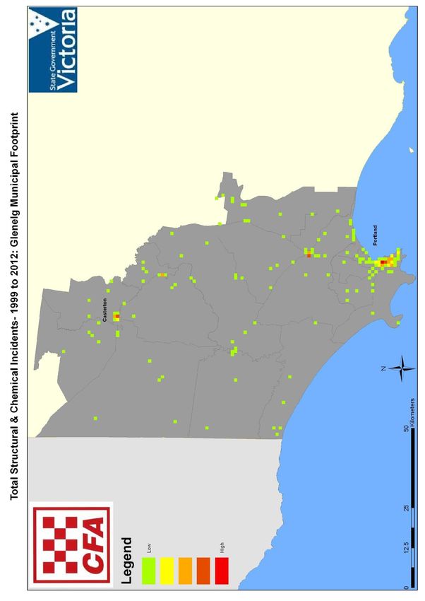
Document Control

VERSION CONTROL

Version               Release Date             Author                Changes
1                                              Ken Ross              Full version
1.1                   25 May 2017              Lynne McMahon         Minor changes
1.2                   17 May 2018              Lynne McMahon         Minor changes

AMENDMENT RECORD

Amendment No           Author           Pages Numbers Amended              Release Date
1                      L McMahon        Minor adjustments to               25 May 2017
                                        incorporate MFMPC and
                                        MEMPC review, minor editing
                                        and formatting improvements.
2                      L McMahon        Minor administration update to     17 May 2017
                                        the Plan.
                                        Barwon South West Fire Sub
                                        Committee endorsed the Plan
                                        at the meeting on 23/02/2018.

Glenelg Municipal Fire Management Plan (version1.1)       May 2017                        2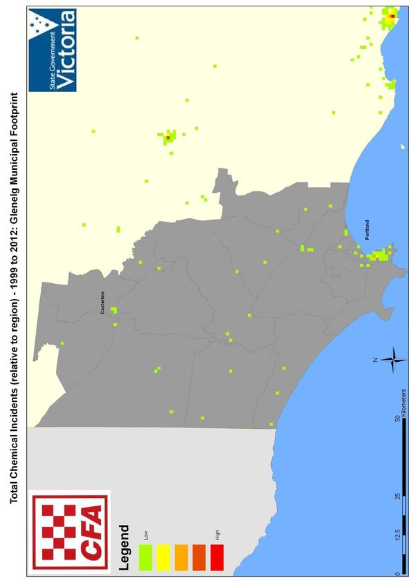
FORWORD This Glenelg Municipal Fire Management Plan (the Plan) identifies priority risks across the entire Glenelg Municipal Area and integrates a wide range of programs to address these risks. Programs are identified for prevention, preparation, response and recovery during and in the period following significant events. The Plan addresses a range of risk environments, including fires in residential, commercial, industrial and marine environments, bushfires and hazardous material environments. Unfortunately we are all familiar with the consequences of incidents which occur and know that future incidents in all these environments are likely to re-occur. This Plan seeks to focus on and integrate with all programs delivered for the community to reduce the likelihood and severity of future events and to assist with community recovery following those incidents that inevitably occur. This Plan has been developed by the Glenelg Municipal Fire Management Planning Committee which is a partnership of key organisations with responsibilities in the identified risk environments which occur across the Glenelg Shire: Country Fire Authority; Department of Environment, Land, Water and Planning; Victoria Police; Glenelg Shire Council; Parks Victoria; Forest Owners Conference; VicRoads; Wannon Water; and Community representation. Where appropriate, other organizations have also been invited to contribute towards the development of this Plan. Importantly, this Plan will be available for engagement with the community of the Glenelg municipality to make contribution and assist in the Plan’s implementation and future development and review. Cr Karen Stephens Chairperson Glenelg Shire Municipal Fire Management Planning Committee Glenelg Municipal Fire Management Plan (version1.1) May 2017 3
CONTENTS

SECTION 1 INTRODUCTION                                           Page 6

SECTION 2 ENGAGEMENTS AND COMMUNICATIONS                         Page 9

SECTION 3 SUMMARY OF THE ENVIRONMENTAL SCAN                      Page 12

SECTION 4 GLENELG SHIRE FOOTPRINT FIRE MANAGEMENT OBJECTIVES Page 18

SECTION 5 FIRE MANAGEMENT RISK STRATEGIES                        Page 22

SECTION 6 IMPROVEMENT, PLAN REPORTING AND REVIEW PROCESSES Page 26

SECTION 7 APPENDICES
             A1. Bushfire Risk Management Register               Page 28
             A2. Structure Fire Risk Management Register         Page 36
             A3. Hazardous Materials Risk Management             Page 38
             B.   Multi Agency Work Plan                         Page 39
             C. Statutory Audit Obligations                      Page 54
             C1. Hazardous Trees                                 Page 55
             C2. Community Information Guides                    Page 58
             C3. Neighborhood Safer Places                       Page 59
             C4. Community Fire Refugees                         Page 60
             D. Engagement and Communications Plan               Page 61
             E. Maps                                             Page 62
             F. Terminology used in this Plan                    Page 67
             G. Anonyms used in this Plan                        Page 71
             H. Bibliography                                     Page 72
             I.   Committee Members                              Page 73

Glenelg Municipal Fire Management Plan (version1.1)   May 2017            4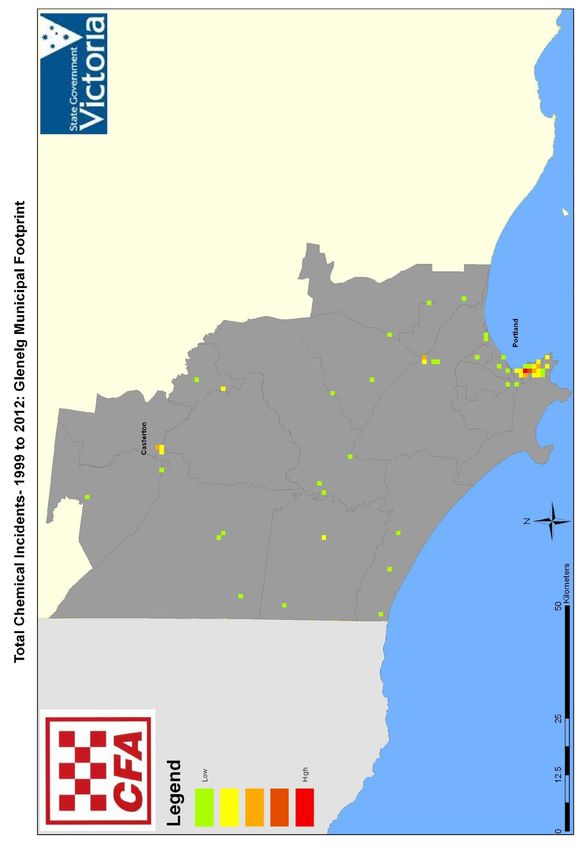
Authorisation and Endorsement This Glenelg Municipal Fire Management Plan was written in partnership with the agencies listed below: Glenelg Shire Council; CFA Regional Director; DELWP SW Regional Manager; Parks Victoria; Vic Roads: Regional Director; Victoria Police: Superintendent; Wannon Water: Managing Director; and MEMPC Chairperson. Note: original signatures received as dated are on Glenelg Shire Council file copy. Glenelg Municipal Fire Management Plan (version1.1) May 2017 5
Section 1 Introduction
The Glenelg Shire is located in a bushfire prone environment dictated by a climate of wet
winters and hot dry summers. Fire management requires an understanding of the role fire
plays and the threat it poses to life and property, in biodiversity retention and the
management of our parks and forests.

Reducing the likelihood and impact of bush, structural and hazardous material incidents is a
shared responsibility of local government, lead agencies, industry and the community.

In particular, lead agencies and local government have a statutory obligation and each
identified in this plan and there is an expectation to demonstrate a lead role in managing
these risks.

This approach requires integrated fire management planning and activity to occur across
bushfire, structural fire and hazardous material risk environments. This Plan is developed to
assist stakeholders meet their legal obligations and support the development of safer
environments at a local level.

It uses a ground up approach to guide lead agencies, municipalities, key stakeholders and
the local community to understand and manage priority structural and hazmat risks at a
local level. Aggregation of the local information and activities from this and other local plans
is considered paramount to manage contiguous risks that span across local areas,
municipal boundaries and broader landscapes

This approach follows the values based decision making process to identify and manage
priority risks, consistent with the other sections of this Plan. Each priority value, risk and
action/treatment are identified and mapped to form decision making processes and to
represent changes in risk ratings over time. Desired outcomes and continual improvement
processes are also provided to demonstrate how the implementation of this Plan will reduce
risks, continually improve and report residual risk levels.

Relevant Barwon South West Regional Fire Management Plan priorities, objectives,
processes and activities used to manage large scale risks and events throughout the region
are referenced to include Integrated Fire management Plan information and implementation
at regional and local level.

This Plan is a sub-plan of the Glenelg Municipal Emergency Management Plan. It is risk
based and has been developed applying principles outlined in the Integrated Fire
Management Planning Framework and Guide and the Guidelines for Municipal Fire
Management Planning, part 6A: Emergency Management Manual Victoria.

Glenelg Municipal Fire Management Plan (version1.1)     May 2017                               6
The purpose of the Plan is to provide a structure for the planned and coordinated
implementation of measures designed to minimise the occurrence and effect of fires in the
geographic area of Glenelg Shire, including the planned use of fire for a variety of purposes.

An important aspect of the Plan is to engage the community providing a valid pathway for
input into the fire management planning process. This ensures the Plan’s relevance to
respond to the needs of the community, it’s values and perceived risks.

The Municipal Fire Management Planning Committee will jointly develop collaborative
planning including the aggregation of current plans as a basis for Integrated Fire
Management Plans (PLAN’s). Planning activities will be aligned to achieve IPLAN within
each organisations planning and business processes through:

•    The implementation of common planning models and methodologies;

•    Allocation of resources and accountabilities;

•    Participation in common decision making through the committee process; and

•    Collaborative delivery of fire management activities.

Cooperative Engagement

The Glenelg Municipal Fire Management Planning Committee is a sub-committee of the
Glenelg Municipal Emergency Management Committee. This Plan is to be considered as
an evolutionary process in the transition from the previous Municipal Fire Prevention Plan to
an integrated Municipal Fire Management Plan which replaces the Municipal Fire
Prevention Plan 2009 - 2014.

Authority for Plan

The Plan has been produced by the Glenelg Municipal Fire Management Planning
Committee and has received the endorsement of the Glenelg Shire Council pursuant to
Section 20 of the Emergency Management Act 1986; This Plan will be deemed to fulfil
Section 55A of the CFA Act 1958. The Plan is a sub plan of the Glenelg Municipal
Emergency Management Plan (MEMP).

Glenelg Municipal Fire Management Plan (version1.1)    May 2017                              7
Period of Plan

Municipal Fire Management Plans have a three year planning cycle and this Plan has been
endorsed for a period of 36 months commencing from the date of Council adoption of the
plan (page 5).

Planning Process

This Plan has been prepared by the Municipal Fire Management Planning Committee as an
advisory committee to Glenelg Shire Council in accordance with the Integrated Fire
Management Planning process.

The Plan addresses both public and private land across the prevention, preparedness,
response and recovery continuum. The Plan will be reviewed and updated each year to
ensure it incorporates new strategies, programs and tools developed by the State Fire
Management Planning Committee and the Barwon South West Regional Strategic Fire
Management Planning Committee ensuring it meets the Municipal Fire Management
Planning Committee and community needs and expectations.

The planning process is based on the identification and assessment of risks within the
geographic area of the Glenelg Shire. For Bushfire, this was undertaken utilising the
Victorian Fire Risk Register (VFRR) process. For Structural Fire and HAZMAT incidents, the
risk assessment methodology was consistent with NERAG 2011 and SERAM 2011 using
PIPE$S.

The Municipal Fire Management Planning Committee then validated this work and will
complete an analysis to establish priorities and develop a range of measures to mitigate the
risk. These measures, or treatments, will then link to the appropriate agency plans. The
measures and treatments identified as a part of this Plan are lifted from the superseded

Glenelg Municipal Fire Management Plan (version1.1)   May 2017                             8
Municipal Fire Prevention Plan and as such will be incorporated in current relevant agency
plans.

The Plan is not designed to duplicate existing plans but it is to consolidate and coordinate
the significant range of plans that exist within Glenelg Shire related to fire events. Linkage
to agreed work plans at the regional level is achieved through the agreed local work plans.

Stakeholder Analysis

The Plan stakeholders are grouped into three categories Primary, Secondary and Tertiary
which describes the level of participation in the development of the Plan. See Attachment
D.2 for the Glenelg Shire Municipal Fire Management Planning Committee Stakeholder
Identification & Engagement Matrix.

Community and Organisational Engagement Process

The ability of a community to respond to a fire situation and in turn recover from the effects
of a fire will depend on the attitude of the people affected, and as such varies widely.
Achieving the most effective response from people during a fire will require community and
organisational engagement, education and awareness programs to be implemented for this
purpose.

With this context in mind the Municipal Fire Management Plan aims to collate and integrate
agency and Council prevention and awareness programs within the Glenelg Shire Municipal
Area.

Key agencies include (but are not limited to):

•    Country Fire Authority;
•    Parks Victoria;
•    Department of Environment Land, Water & Planning;
•    Vic Roads;
•    Victoria Police;
•    Glenelg Shire Council; and
•    Forest Industry.
Section 2 Engagement and Communications

The Plan was written with the support of the following stakeholders that are signatories of
the Plan; Glenelg Shire Council, Country Fire Authority, Department of Environment, Land,
Water and Planning, VicRoads, Victoria Police, Parks Victoria and representatives of the
Forestry Industry.

The Plan Committee developed, reviewed and endorsed the Plan on 27 November 2013.

The Plan Committee has conducted a minor reviewed of the Plan in May 2017 due to the
State Strategic Municipal Fire Management Plan under review.
The Barwon South West Regional Strategic Fire Management Planning Committee
reviewed and endorsed the current Plan at the meeting held on 23 February 2018.

Glenelg Municipal Fire Management Plan (version1.1)    May 2017                              9
The authorisation page of the Plan (page 5) commits each organisation in the Plan to
implement and report on the actions detailed within the Plan.

The value and importance of engagement and communications with regard to emergency
management planning activities has been acknowledged through the development of a
supporting Glenelg Shire Emergency Management Planning:           Community and
Organizational Engagement Plan.

This information is designed to support further engagement activities and is designed to
assist stakeholders to integrate the use of proposed State support tools.

Community and organisational engagement is undertaken to inform the planning process by
identifying areas of risk; values to be protected and community and organisational fire
management needs.

Outcomes

Through shared commitment and agreement on outcomes, all key stakeholders will ‘own’
the project and ensure that outcomes are not predetermined.

The Glenelg Shire Emergency Management Planning: Community and Organisational
Engagement Plan provide a local communication, engagement and participation strategy for
the development of Municipal Emergency Management Plans including this Fire
Management Plan. It has been developed to enhance communication and stakeholder
engagement using IAP2 principles outlined below, and fulfils the requirements of this
section of the Plan.

Inform

Provide appropriate, detailed and accurate information to assist stakeholders in developing
a shared understanding of the complexity of issues and possible solutions.

Consult

Utilise stakeholder expertise and diversity to obtain appropriate and accurate input into
analysis, solutions and key decisions.

Involve

Work directly with the suite of key stakeholders throughout the various processes to ensure
identified issues and intent are understood and considered.

Collaborate

Partner with key stakeholders in each aspect of decision making. This includes the
development of alternative solutions, the identification of contributions and priority actions
(with a clear understanding of the responsibilities of each stakeholder).

Glenelg Municipal Fire Management Plan (version1.1)    May 2017                             10
Empower

Foster and promote transparent and accountable processes that allow each stakeholder
organisation to empower themselves through key actions and the implementation of
responsibilities.

Glenelg Municipal Fire Management Plan (version1.1)   May 2017                    11
Section 3 Summary of the Environmental Scan
Location and Land Tenure

The Glenelg Shire Municipal Fire Management Planning Committee is located in South
Western Victoria and is a part of the Barwon South West Region. The land area of the
Glenelg Shire is 665,100 hectares. Estimates of the area ascribed to various land
managers are outlined in the Table below.

Barwon South West Environmental Scan

To view the Barwon South West Region Environmental Scan, follow the link:
Barwon South West Region Environmental Scan

Table: Glenelg Shire Land Managers

                                                          Estimated area
               Key Land Managers                                             Area of Shire %
                                                          managed (Ha)

    Council – owned land                                               995                 0.2

    Council - management delegated by
                                                                       408                 0.1
    DELWP

    Road Reserves (Disused, VicRoads
                                                                   123,832                19.9
    and Council managed)

    DELWP - State Forest and
                                                                    68,201                11.0
    Cobboboonee Forest Park

    Parks Victoria – National and State
                                                                    81,300                13.1
    Parks and reserves

    DELWP Committees of Management
                                                                      1093                 0.2
    – elected (Public use reserves)

    DELWP Crown land managers - other                                  777                 0.1

    TOTAL PUBLIC LAND                                              276,606                 45

    Remainder - freehold title managed
                                                                   344,004                 55
    as private land

    Total Shire area ( = 6212 sq. km)                              621,200                100
  Data source: Glenelg Environment Strategy 2010 – 2020
 (Areas and percentages are estimates)

Glenelg Municipal Fire Management Plan (version1.1)             May 2017                         12
Natural Environment The area ranges from river table lands to extensive area of forest and national parks. The natural beauty of the Shire features expansive beaches, scenic and rugged coast, large national parks, large areas of commercial plantations, extensive wildlife and provides the western access to the world renowned Great Ocean Road. Approximately 22% of Australia’s dairy production comes from our region. Dairying is projected to increase at the rate of 4% per annum to the year 2015. More than 40 % of Melbourne’s fresh fish to market comes from the Port of Portland and 20% of Australia’s timber plantations are located within the Green Triangle region of South East Australia. The large majority of the blue gum timber plantations now being harvested are located within the Glenelg Shire. The Shire is home to the Port of Portland, one of four major ports in the State. The shire is home to a range of significant industries including manufacturing, engineering and horticulture. Portland Aluminium, and Point Henry Geelong, was Victoria’s largest exporter and together produces approximately 30% of Australia’s total aluminium production. Point Henry Geelong closed down in August 2014. We have an increasingly valuable natural competitive advantage through opportunities to supply new age energy including wind power, wave power, geothermal and natural gas power production. The opportunity to capitalise on eco tourism and the promotion of the natural assets, recreation and adventure experiences within our area also offers great potential. In addition to managing the economic instability created by the global financial turmoil, Glenelg Shire must manage the opportunities and mitigate the threats provided through climate change. This includes protecting increasingly valuable primary production areas, enhancing and preserving our biodiversity and ensuring coastal risk management issues, such as sea level rise and coastal erosion, together with water shortages and increases in temperatures and storm events are accommodated within our lifestyles and communities. In addition to the changes in our industry base and the ongoing climate change, the structure and makeup of our communities are also changing. Sensis data indicates approximately 80% of our population are residents born in Australia with only 2.7% of our citizens from non-English speaking backgrounds. Approximately 2% of Glenelg’s population is indigenous which makes Glenelg an area with one of the largest indigenous populations within the state. Our community is ageing with 20% of residents aged 60 years and older. This is predicted to increase to more than 46% of our population by 2030. Glenelg Shire, in many respects, has high levels of community wellbeing and liveability. Relatively affordable levels of housing, combined with good employment prospects and attractive natural settings, make the Shire a potentially appealing place for visitors and residents. However, there are some significant community health and wellbeing issues that need to be addressed. These include a life expectancy for both men and women that is, respectively, 3.6 and 2.8 years below the Victorian average. Whilst significant portions of our population have quality housing and comparatively high levels of accommodation, Glenelg Municipal Fire Management Plan (version1.1) May 2017 13
pockets have also been identified where education levels, standards of housing and general
health and wellbeing of residents are lower than other regional areas of Victoria.

Our Shire boasts expansive beaches, scenic and rugged coastline, large national parks,
Australia’s first geo park – Kanawinka, extensive wildlife and western access to the world
renowned Great Ocean Road.

Glenelg Shire is the traditional lands of the Gunditjmara and Bunganditj people with their
rich indigenous history. It is also the site of the first permanent European settlement in
Victoria. We have a responsibility to protect and preserve our natural and cultural assets
whilst at the same time embracing progress through responsible development and
presentation of our urban areas. We will continue to support new and ongoing community
cultural events and experiences that help to define our region.

Climate and Bushfire Season

The typical/average climate in the Glenelg Shire has winters which are normally very wet in
the south, cold frosts in the north with occasional heavy rains.

The spring season can be unpredictable and varied and often sees occasional severe
thunderstorm activity.

The summer season has long hot dry spells with occasional mild conditions which can
include thunderstorm activity. The fire danger period generally runs from October to April.

Prevailing weather conditions associated with the fire danger period in the Glenelg Shire are
north westerly winds accompanied by high daytime temperatures and low relative humidity.
There are also frequently dry lightning storms occurring in the north during the fire danger
period. Coastal winds influence the conditions from time to time.

Population and Demographic Information

The population of the Glenelg Shire is approximately 16,800 people. The major population
centres are Portland, Heywood and Casterton. The following issues have been identified
within the Glenelg shire area as potentially impacting on the ability of certain sections of the
community to prepare themselves for bushfire: seasonal population changes, high tourism
areas E.g.; Nelson and Cape Bridgewater, high level of itinerant farm labour, high level of
non-resident property owners or those travelling out of town for work.

Land Use and Economy

The Shire’s rich soils and reliable rainfall provides the basis for cattle and prime lamb
grazing, cropping, wool production thriving timber plantation/harvesting, viticulture, and dairy
production. The region is responsible for one of the highest levels of agricultural production
in dairy, wool and meat in Victoria.

The existing 550KV power line to Portland provides an opportunity for Great South Coast
(GSC) wind energy facilities to contribute an additional 3000-4000MW of power to the
national grid and as such, the region will increasingly become a major contributor to the
state’s electricity supply. The predecessor to the Australian Energy Market Operator,
VENcorp, stated that most of Victoria’s wind power generation will occur in western and
south western Victoria.

Glenelg Municipal Fire Management Plan (version1.1)     May 2017                              14
South West Victoria currently accounts for a significant number of the total wind farms in
Victoria. As green energy becomes increasingly viable it is expected that further
development and investment in wind generators will increase.
Outputs of environmental scanning - Assumptions about the future of the municipality are
for longer and hotter summers, an increase in plantations, an aging population, aging and
poorly maintained infrastructure and decreasing fire fighting volunteer capability will
potentially place Glenelg Shire at a higher risk level in the future.
Bush Fire History
Fires have caused devastation in the municipality on many occasions, including the
following major incidents:
1851 – in February (“Black Thursday”) when a total of 5 million hectares or ¼ of
Victoria burnt including a large area around Portland.
1939 – in January (“Black Friday”) when 2 million hectares of Victoria burnt including
most of the now Glenelg Shire, and including Portland, Heywood, Bridgewater,
Tyrendarra, Condah, Lyons, Dartmoor, Rennick, Strathdownie and Tullich.
1976 - January much of the Cobboboonee State Forest west of Heywood was burnt
following a series of lightning strikes.
1979 – in February fires swept into the Nelson area from Caroline in South Australia
after travelling 27 km. The fire burnt 7,700 hectares, including 3,300 hectares of pine
plantation and 4,200 hectares of Lower Glenelg National Park.
1991 - in February a large fire burnt approximately 12,000 hectares in the Lower
Glenelg National Park and Cobboboonee State Forest.
2000 - a fire started in farmland at Kentbruck near the coast and spread rapidly for
eight kilometres under south west winds, burning through pine plantations and Lower
Glenelg National Park.
2005 - a fire started from a prescribed burn at Dunmore lit several days previously and
burnt for eleven kilometres under northerly winds through Mt Eccles National Park,
farmland and blue gum plantations towards the coast.
2006 - a fire at Tyrendarra was ignited by lightning in farmland east of Heywood and
spread for several days across farmland, rough lava flow areas along the Fitzroy
River. The fire threatened communities in the Tyrendarra and Narrawong areas
before eventually being controlled near the coast.
2006 – in October a 10,000 hectare fire burnt in the area west and north of Casterton
after a massive lightning event caused a series of fires across the shire.
2012 – in November a fire ignited by lightening occurred near Casterton and burnt
over 4400ha including approximately 100ha of blue gum plantation.
Glenelg Municipal Fire Management Plan (version1.1) May 2017 15 2013 – on 4 January a fire started in the Kentbruck area and over the course of the
following 7 days burnt over 12000ha. No serious injuries, no loss of life and no loss of
major structures in this event however plantation assets were lost with a reported
economic loss of $12 million.
2013 – in March a fire started in the Cashmore area and spread quickly across
grassland posing a threat to properties in Portland’s West burning approximately
144ha in area.
2014 – a fire started in the Mount Clay/Narrawong state forest burning an area of
approximately 1300 hectares.
2015 – in November a peat fire started in the Ardno/Kaladbro area. The fire was
approximately 12 hectares in size in a 400 hectare peat swamp. The fire continued for
2 weeks and was caused by lightning strike.
2018 – in January a building fire start on ???Road Mumbannar and in total burnt
approx. 55ha of plantation and farming land. There were no loss of life or major
structures in the event.
Structural Fire History
Structural fires occur regularly within all structural environments including heavy industrial
sites, light industrial sites, residential properties, medical and supported residential
accommodation, commercial properties and marine structures. The following are some of
the major incidents within the past fifteen years:
Several significant commercial fishing boats fires within the Port of Portland in 1992
(with several lives lost), 1997 and 1999 and 2008;
A large and complex fire in the overhead conveyor system at the Grain Corp facility in
the Port of Portland in 2005;
A large fire at the wood chip unloading facility within the Port of Portland in 2006;
Regular incidents at the Portland Smelter with notable incidents occurring in 2004,
2008 and 2011;
Commercial property fires such as the Portland IGA Supermarket fire (2012); and
Heywood Newsagency (2012).
By association, a substantial fire at the Telstra exchange in Warrnambool in 2012 had
a considerable widespread impact on communications throughout Victoria’s south-
west. Emergency services have become more reliant on this communications network
for their day-to-day operations and this event highlighted the need for adequate
redundancies in the event of failure.
In 2015 at the Port of Portland the Awassi Express Ship was berthed at the port
waiting to load 17,000 head of livestock. After loading the fodder a fire broke out and
this caused a very completed incident run under CFA control over 11 days.
Glenelg Municipal Fire Management Plan (version1.1) May 2017 16 Two portables at the Portland Secondary College caught on fire causing significant
damage to the buildings. It is alleged that the fire was started by a stray flare that was
let off some hours prior to the fire igniting (March 2017).
Fire statistics maintained by CFA reveal a number of causes of structural fires with human
causes and arson being the two most common.
Hazmat History
Hazardous material incidents do not occur frequently and are most common in industrial
and similar environments. Notable incidents in recent years include the following:
A large chlorine leak at the Port of Portland in 1998;
An acid spill at the Portland Smelter in 2003;
Multiple chlorine leaks at the Heywood Swimming Pool between 2006 and 2011, and
at the Casterton Swimming Pool; and
A very significant and lengthy operation for the control and clean-up of a leak from the
Koppers (Australia) Liquid Pitch Facility at the Port of Portland in February 2012.
Power outage (6 hours) at the Portland Aluminium Smelter causing loss of production
to the company’s production line.
In addition to the above, incidents also occur on major transport corridors (eg. Trucks
operating on the Princes Highway) but may also occur on properties in rural areas.
Glenelg Municipal Fire Management Plan (version1.1) May 2017 17Section 4 – Glenelg Shire Footprint Fire Management Objectives
The aim of the Plan is to protect:
Life;
Critical Infrastructure;
Property;
Sustainability, productivity and economic health, particularly agricultural and forestry
industries;
Environmental Values; and
Cultural Values.
Under the Country Fire Authority Act 1958 (section 55A), this Plan must contain provisions
for:
Identifying areas, buildings and land use in the Glenelg Shire footprint that are at
particular risk in case of fire;
Specifying how each identified risk is to be treated and who is responsible for treating
those risks; and
Identifying all designated neighbourhood safer places in the Shire.
The Glenelg Shire is required under section 43 of the Country Fire Authority Act 1958 to
take all practicable steps (including burning) to prevent the occurrence of fires on, and
minimize the spread of fires on and from:
Any land vested in the Shire or under its control and management; and
Any road under its care and management.
To meet these objectives and requirements, this Plan has been developed as a planning
and strategic document. The Plan identifies communities and assets at risk through an
Environmental Risk Scan and the Victorian Fire Risk Register (VFRR). The VFRR is a risk
prioritisation tool that identifies assets at risk, assesses the level of bushfire risk to assets
and identifies a range of treatments to mitigate the risks. Treatments may include activities
such as fuel reduction, community education, preparedness programs and property
planning.
The Plan also references treatments for the five regional risk priorities (listed above)
identified by the Barwon South West Regional Strategic Fire Management Planning
Committee. A copy of the VFRR Municipal Risk Register for the Glenelg Shire, with risks
presented by the regional risks prior to 2012 is attached (appendix A)
Glenelg Municipal Fire Management Plan (version1.1) May 2017 18Alignment to Regional Objectives
The Barwon South West Regional Strategic Fire Management Planning Committee has
resolved that the priorities to be addressed are:
1. Demonstrate effective leadership;
2. Understand the Barwon SW region;
3. Identify our priority assets and values;
4. Support our values whilst managing priority risks; and
5. Continue to improve and evolve.
In order to achieve the objectives of this plan the principles of the regional objectives will be
applied. The development of S.M.A.R.T. (Specific, Measurable, Attainable, Realistic and
Timely) goals to support the alignment of regional and local objectives will be a primary
focus of activity for the Municipal Fire Management Planning Committee in 2012/15.
A regional committee workshop in 2012 developed the above five BSW fire priorities using
VFRR data. A previous committee workshop in September 2011 had previously reviewed
this information and identified the following priority regional values at risk from fire following
the PIPE$ model:
P People
Community assets. Including community houses, hospitals, schools caravan
parks, accommodation facilities, and commercial outlets;
Townships. Including coastal, hinterland and urban (interface); and
Vulnerable communities. , such as tourists older people, disabled people,
absentee homeowners, Aboriginal and Torres Strait Islanders (ATSI) and
Culturally and Linguistically Diverse (CALD).
I Infrastructure
Essential services. Including water and energy supply, telecommunications and
sewerage systems;
Hospitals and social infrastructure; and
Regionally significant roads and bridges.
P Public Administration
Capability and capacity for agencies, councils and service providers to be
maintained before during and after bushfire events;
Health services and
Cross agency planning and response.
Glenelg Municipal Fire Management Plan (version1.1) May 2017 19E Environment and Cultural Heritage
Natural Environment
National Parks including indigenous flora, fauna and sites of significance;
Water Quality e.g. water catchments and environmental systems for ecological
benefits and potable use;
Listed/significant environmental assets including RAMSAR wetlands; and
Threatened species and communities, regionally significant wetlands etc…
Cultural Heritage
Indigenous heritage sites;
European heritage sites; and
Historic townships.
$ ECONOMIC
Major industries;
Farming; and
Road, rail, shipping ports and airports.
Outcomes
The desired outcomes of this Plan are:
Human life and critical infrastructure are protected in the Shire;
Plans are in place and activities undertaken to minimise the risk of fire and to suppress
uncontrolled fire and hazmat incidences which may occur within the Shire;
Members of the Municipal Fire Management Planning Committee actively seek
opportunities for agency collaboration to improve outcomes for communities and to
reduce duplication;
All agencies contribute to and are accountable for implementing agreed treatments;
and
Communities within the Glenelg Shire have an improved understanding of fire in their
environment and their shared responsibility for action to reduce the risk of fire.
Strategic Directions
The strategic direction of this Plan aligns directly with the State Fire Management Strategy
2009.
Glenelg Municipal Fire Management Plan (version1.1) May 2017 20The State’s vision for fire management in Victoria involves:
Active participation of the community, the fire management sector and government,
working together in fire management planning to reduce the destructive impact of fire
on communities and the environment;
Communities that are resilient to the effects of fire;
Greater understanding of the fire sector within the community; and
Healthy natural, social and built economic environments.
In addition, the ongoing development of this Plan will also consider the following broad
strategic documents:
Fire Services Reform Program and Action Plan, (June 2011), Fire Services
Commissioner;
Implementing the Government’s Response to the 2009 Victorian Bushfires Royal
Commission, (May 2011), State Government of Victoria;
Bushfire Safety Policy Framework, (September 2011), Fire Services Commissioner;
Living with Fire – Victoria’s Bushfire Strategy, (June 2008), State Government of
Victoria.
Links to Other Business and Programs:
www.cfa.vic.gov.au
http://www.delwp.vic.gov.au
http://www.ffm.vic.gov.au
www.glenelg.vic.gov.au
https://www.emv.vic.gov.au/
www.mav.asn.au
www.vicroads.vic.gov.au
www.parkweb.vic.gov.au
www.victrack.com.au
www.police.vic.gov.au
Glenelg Municipal Fire Management Plan (version1.1) May 2017 21Section 5 Fire Management Risk Strategies
Management of risk is an integral part of good business practices and quality management.
Understanding risk and learning how to manage it effectively enables fire services,
government agencies, municipalities and the broader community to reduce hazards and
risks by identifying and analysing issues which could threaten communities and providing a
systematic way to make informed decisions to mitigate or reduce those threats to an
acceptable level.
Ongoing monitoring and review is essential to ensure that the Glenelg Municipal Fire
Management Plan remains relevant and up to date with specific attention to:
Changes to community demographics and level of risk;
Changes to organisational responsibilities or legislation (e.g. as a consequence of a
Royal Commission); and
Following a major fire event.
These and other factors may affect the likelihood and consequences of an outcome, as they
can affect the suitability or cost of the treatment options. It is therefore necessary to repeat
the risk management cycle on a regular basis by conducting an annual review. Because the
risk from bushfire is prominent within the country area of Victoria, the annual review will
occur prior to each bushfire season. The review process shall also ensure new strategies,
programs and plans developed by the State and Regional Fire Management Committees
are considered and incorporated where appropriate and meets community expectations.
The Glenelg Shire Municipal Fire Management Planning Committee will also review this
plan as necessary to account for any changes in context or risk. The Municipal Fire
Management Planning Committee will also provide a Status Report (as determined by the
Municipal Fire Management Planning Committee) on fire management across the PPRR
continuum of the 5 priorities determined by the Barwon South West Region Fire
Management Committee.
Background to Victorian Fire Risk Register (VFRR)
The VFRR is a Victorian version of a mapping application developed by the NSW Rural Fire
Service to assist in the bushfire risk management planning process. It is a systematic
process involving experts from a range of key stakeholders identifying assets at risk from
bushfire, assessing their level of risk and assigning a range of treatments to mitigate the
risk. Treatments may include activities such as fuel reduction, community education
programs and safety audits.
Using the categories of Human Settlement, Economic, Environmental and Cultural Heritage,
assets were identified and their level of risk assessed based upon consideration of a range
of characteristics including proximity to flammable vegetation, vegetation type, slope and
frequency of fires.
The VFRR has enabled the Glenelg Municipal Fire Management Planning Committee to
enter risk reduction treatments and link these treatments to assets. The primary output of
the VFRR is a Municipal Bushfire Risk Register table (Appendix A.1) with maps showing
assets and satellite imagery, as well as a list of treatments assigned to each asset.
Glenelg Municipal Fire Management Plan (version1.1) May 2017 22The objective of the VFRR is to provide fire planners with evidence based data and
information to better inform bushfire management planning in achieving:
Tenure blind, integrated fire management planning across the landscape;
A reduction in the number of human induced bushfire ignitions that cause damage to
life, property and the environment;
effective fuel management to reduce the rate of spread and intensity of bushfires while
minimising environmental/ecological impacts;
A reduction in community vulnerability to bushfires by improving preparedness; and
Effective containment of fires with the potential to cause damage to life, property or the
environment.
The VFRR identifies the following asset classes:
Asset Class Asset Subclass
Residential
Human Settlement Special Fire Class
Other
Agriculture
Commercial
Infrastructure
Economic Tourist & Recreational
Mines
Commercial Forests
Drinking Water Catchments
Locally Important
Environmental Endangered
Vulnerable
Aboriginal Significance
Cultural Heritage Non Indigenous
Other
Structure and Hazmat Fire Risk
Introduction
This structural and hazmat section of the Plan aims to uphold the primacy of human life,
whilst implementing risk management treatments that support our local values.
Reducing the likelihood and impact of structural and hazmat incidents is shared
responsibility between Government, Lead Agencies, Industry and the Community.
In particular, Municipalities and Lead Agencies have a duty of care by law and each
identified in this plan are expected to play a leadership role in managing these risks.
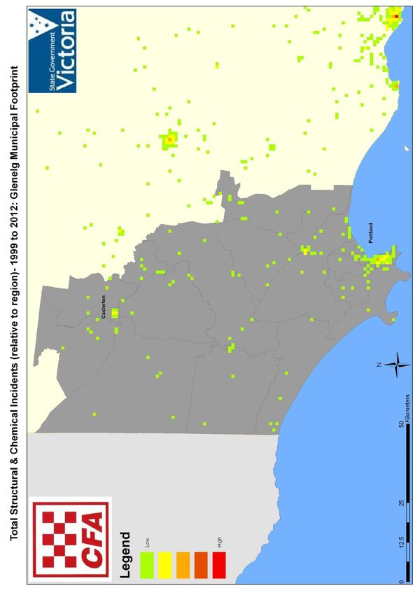
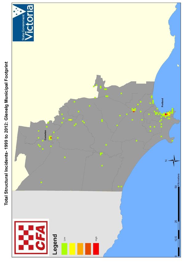
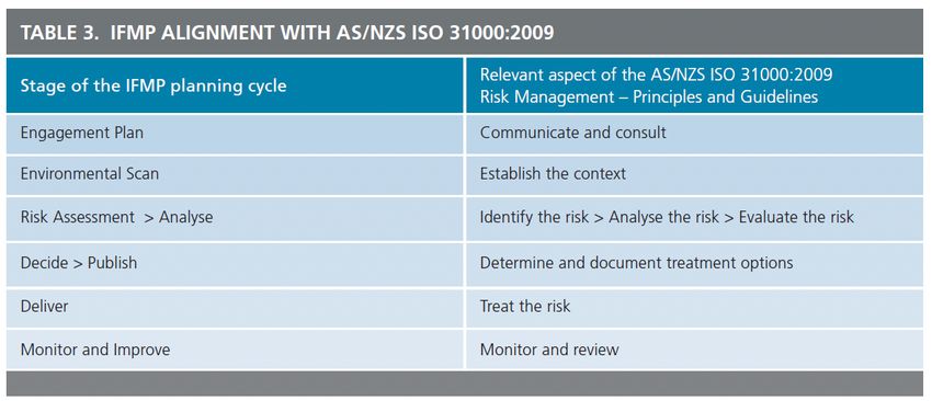
Glenelg Municipal Fire Management Plan (version1.1) May 2017 23Context This structural and hazmat section of the Plan is an interim guide, developed to assist stakeholders to meet their legal obligations and support the development of safer environments at a local level. It uses a ground up approach to guide Municipalities, lead agencies, key stakeholders and the local community to understand and manage priority structural and hazmat risks at local a level. Aggregation of local information and activities from this and other local plans is considered paramount to manage contiguous risks that span across local areas, municipal boundaries and broader landscapes. Risk Assessment and Prioritisation Considerations The method of analysis to determine the hazmat and structural risk within the local government area of Glenelg has revolved around a review of the historical incident data. Data from 1999 to the present have been collated and analysed with the assistance of the State Fire Management Planning Support Team (SST) to produce a range of views to support decision making for the priority of these two risk areas. Methodology The Risk Assessment and management methodology used in the development of this plan is informed by and consistent with the following: AS/NZS ISO 31000:2009, and NERAG 2011. Risk Management Process: 1. Identify Risk; 2. Analyse Risks; 3. Evaluate Risk; 4. Apply Risk Treatment; and 5. Monitor and Review. Included in this plan is a matrix of the priority fire risks in the municipality; Appendix A. Treatments and actions to achieve fire management strategy (including timelines and areas of responsibility) are contained within the Multi Agency Work Plans located in Appendix B. Risk Treatments At the higher level generic risk treatments exist such as the Victorian Planning Scheme, Building Regulations and the Building Code of Australia (BCA). In addition to these every fire and land agency has had in place for many years various fire management strategies to treat the bushfire risk include: Glenelg Municipal Fire Management Plan (version1.1) May 2017 24
Fuel Hazard Reduction e.g. DELWP planned burn program, multi-agency slashing
programs;
Ignition Management e.g. Electrical Safety (Electric Line Clearance) Regulations 2010;
Community Education e.g. CFA Community Fireguard, Fire Ready Victoria;
Preparedness e.g. Community Information Guides, multi-agency Fire Management
Plans, specific premises pre-plans; AND
Property planning e.g. private property inspections, planning and building legislation.
Glenelg Shire Action Plan Summary
NOTE: Whilst individual agency programs are listed under the most relevant program
heading, they may deliver outcomes in multiple areas.
(Refer to individual Agency Programs for details, Pages 19-27)
CFA – Country Fire Authority
DELWP - Department of Environment, Land, Water and Planning’
GSC - Glenelg Shire Council;
VICPOL – Victoria Police;
PV - Parks Victoria; and
VR – VicRoads.
Glenelg Municipal Fire Management Plan (version1.1) May 2017 25Section 6 Improvement, Plan Reporting and Review Processes
Plan Endorsement and Adoption
The Glenelg Shire Council is the custodian of the Plan pursuant to current legislative
arrangement. All partnership agencies involved in the development and implementation of
the Plan are signatories. All signatories must sign off on their respective activities,
responsibilities and components of the Plan.
The Plan must be endorsed by the MEMPC prior to submission to Council for their adoption.
This obligation may change in subsequent versions as Plan processes evolve. Fire services
must attest to the rigour of the planning processes.
Plan Amendment and Review
The Plan is reviewed and updated regularly by the Municipal Fire Management Planning
Committee to ensure it meets community needs and expectations. This review takes into
account works completed, environmental changes and any additional risks. Significant
changes, including planning mitigation works, must be approved by the Municipal Fire
Management Planning Committee and submitted through the MEMPC to Council for
adoption.
The Plan will be reviewed and amended:
Annually in association with the MEMP;
Changes to the VFRR data will be updated in the plan;
The Municipal Fire Management Planning Committee will review the implementation of
the treatments applied to VFRR identified risks by each agency (as appropriate);
Requirement for additional or alternative treatments to mitigate identified risks will be
assessed;
Following a significant incident, if required;
As directed by the State or Regional Fire Management Planning Committees; and
As required by legislation.
Private Fire Bunkers
Private fire bunkers are the responsibility of individuals and do not form a part of this Plan.
Cross Boundary Arrangements
It is acknowledged that the Glenelg Shire Council and stakeholder agencies have existing
planning relationships across the following boundaries:
Moyne Shire;
Southern Grampians Shire;
Glenelg Municipal Fire Management Plan (version1.1) May 2017 26 West Wimmera Shire;
Southern Border Fire Control Association Guidelines 2011; and
CFA (Vic) – CFS (SA) Memorandum of Understanding.
Monitor & Review
Ongoing monitoring and review is essential to ensure that the Plan remains relevant and up
to date with specific attention to:
Changes to community demographics and level of risk;
Changes to organisational responsibilities or legislation as a consequence of the
Bushfire Royal Commission;
The White paper – Future Direction of Emergency Management;
Recommendations following a major fire event.
These and other factors may affect the likelihood and consequences of an outcome, as they
can affect the suitability or cost of the treatment options. It is therefore necessary to repeat
the risk management cycle on a regular basis by conducting an annual review. Because the
risk from bushfire is prominent within the country area of Victoria, the annual review will
occur prior to each fire season.
The review process shall also ensure new strategies, programs and plans developed by the
State and Regional Fire Management Committees are considered and incorporated where
appropriate and meets Council and community expectations. The Glenelg Municipal Fire
Management Planning Committee will also review this plan as necessary to account for any
changes in context or risk; it will provide a Status Report as determined by the Municipal
Fire Management Planning Committee on fire management across the Prevention
Preparedness Response & Recovery (PPRR) continuum of the 5 priorities (PIPE$)
determined by the Barwon South West Regional Strategic Fire Management Committee.
Glenelg Municipal Fire Management Plan (version1.1) May 2017 27APPENDIX A.1
Bushfire Risk Management Register - Glenelg VFRR Data against RSC 5 Priorities (Reviewed October 2017)
Priority 1 High Risk Townships
Asset Sub Asset Consequence Risk Township
Asset Type Asset Name Likelihood Priority NSP adopted
type Location Rating Rating Protection Plans
Completed and
Human Almost Location identified,
Residential Nelson Catastrophic Extreme 1A currently being
Settlement Nelson Certain to be implemented
reviewed
Human Under Location identified,
Residential Dartmoor Dartmoor Likely Moderate High 3A
Settlement development to be implemented
Completed and
Human In place at Portland
Residential Bolwarra Bolwarra Likely Catastrophic Extreme 1B currently being
Settlement Civic Hall
reviewed
To be
Human Cape Cape Suitable location not
Residential Likely Catastrophic Extreme 1B commenced,
Settlement Bridgewater Bridgewater yet identified
2011/2012
Human To be Suitable location
Residential Merino Merino Likely Minor Medium 4
Settlement commenced identified
Human Almost To be Suitable location
Residential Digby Digby Moderate Very High 2C
Settlement Certain commenced identified
Human Under
Residential Sandford Sandford Likely Minor Medium 4 Under consideration
Settlement consideration
Human Portland Almost Under
Residential Portland Major Extreme 1C Under consideration
Settlement North West Certain consideration
Human Under Suitable location
Residential Narrawong Narrawong Likely Moderate High 3A
Settlement Development identified
Human Under
Residential Dutton Way Portland North Likely Moderate High 3A Under consideration
Settlement considerationPriority 1 High Risk Townships continued
Asset Consequence Risk Township
Asset Type Asset Name Asset Location Likelihood Priority NSP identified
Sub type Rating Rating Protection Plans
Human Under Under
Residential Casterton Casterton Likely Minor Medium 4
Settlement consideration consideration
Human Under Under
Residential Casterton West Casterton West Likely Moderate High 3A
Settlement consideration consideration
Human Under Suitable location
Residential Heywood Heywood Likely Minor Medium 4
Settlement consideration identified
Human Under Under
Residential Portland Central Portland Likely Minor Medium 4
Settlement consideration consideration
Human Portland Under Under
Residential Portland Likely Minor Medium 4
Settlement South consideration consideration
Human Portland Under Under
Residential Portland Likely Moderate High 3A
Settlement West consideration consideration
Human Portland Under Under
Residential Portland Likely Minor Medium 4
Settlement South West consideration consideration
Human Portland Under Under
Residential Portland Likely Moderate High 3A
Settlement Sheoke consideration consideration
Human Portland Portland Wyatt Under Under
Residential Likely Major Very High 2A
Settlement Wyatt St St consideration consideration
Human Under Under
Residential Maretimo Portland Likely Moderate High 3A
Settlement consideration consideration
Human Narrawong Almost Under Suitable location
Other Narrawong Catastrophic Extreme 1A
Settlement North Certain consideration identified
Human Under Under
Other Heathmere Heathmere Likely Moderate High 3A
Settlement consideration consideration
Human Under Under
Other Allestree Allestree Likely Moderate High 3A
Settlement consideration consideration
Glenelg Municipal Fire Management Plan (version1.1) May 2017 29Priority 2 Critical Essential Services
Expecte
Do fires
d to
Asset Sub Asset Level of Cost of occur Risk Priorit
Asset Type Asset Name Consequence spread Likelihood
Type Location Impact recovery frequen Rating y
& reach
tly
assets
Mt Clay Sub Almost Extrem
Economic Infrastructure Mt Clay National High Catastrophic Yes Yes 1A
Station Certain e
State
Mt Clay Radio
Communicatio Very
Economic Infrastructure Mt Clay Regional Moderate Major No Yes Likely 2A
ns High
Tower
HYTS-APD
Portland – Very
Economic Infrastructure No. 1& 2 Trans Local High Major No Yes Likely 2A
Heywood High
Line
Koroit-
Koroit Almost Very
Economic Infrastructure Portland 66kv Regional Low Moderate Yes Yes 2C
Portland Certain High
line 2
Warrnambool
Warrnambool Almost Very
Economic Infrastructure – Portland Regional Low Moderate Yes Yes 2C
Portland Certain High
66kv 1
Tullich Bores& Casterton- Almost Very
Economic Infrastructure Regional Low Moderate Yes Yes 2C
Pipe Lines Penola Rd Certain High
HYTS-SESS
National
Economic Infrastructure No. 1&2 SA Link Low Moderate No Yes Likely High 3A
State
T/Lines
MLTS-HYTS
Moyne Shire National
Economic Infrastructure No. 1&2 Low Moderate No Yes Likely High 3A
to Heywood State
T/Lines
Bald Hill
National
Economic Infrastructure WWTS Portland High Catastrophic No Yes Likely Extreme 1B
State
(water supply)
Nelson Mobile
Economic Infrastructure Nelson Local Low Minor No Yes Likely Medium 4
Phone Tower
Casterton
Economic Infrastructure Casterton Local Moderate Moderate No Yes Likely High 3A
WTP
Glenelg Municipal Fire Management Plan (version1.1) May 2017 30Priority 3 Tourism and Major Events
Expected
Do fires
Asset Sub Asset Level of Cost of to spread Risk Priorit
Asset Type Asset Name Consequence occur Likelihood
type Location Impact recovery & reach Rating y
frequently
assets
Cape Nelson Cape
Economic Infrastructure Local Low Minor Yes No Unlikely Low NA
Lighthouse Nelson
Recreation
Tourist and Glenelg
Economic Camps/ Regional Low Moderate Yes Yes Likely High 3A
Recreational Shire
picnic areas
Priority 4 Key Rural Industries
Expected
Do fires
Asset Asset Sub Asset Asset Level of Cost of to spread Risk
Consequence occur Likelihood Priority
Type type Name Location Impact recovery & reach Rating
frequently
assets
Commercial Hardwood Almost
Economic Glenelg Regional High Major Yes Yes Extreme 1C
Forest Plantations Certain
Commercial Softwood Almost
Economic Glenelg Regional High Major Yes Yes Extreme 1C
Forest Plantations Certain
Heywood Very
Economic Commercial Heywood Regional Moderate Major No Yes Likely 2A
Pellet Mill High
Alcoa National
Economic Commercial Portland High Catastrophic No Yes Likely Extreme 1B
Smelter State
Portland Danger
Economic Infrastructure Pine Lane Local Moderate Moderate No Yes Likely 3A
High
Products Heywood
Myamyn
Very
Economic Commercial Woodchip Myamyn Regional High Major No Yes Likely 2A
High
Mill
Glenelg
Economic Infrastructure Wind farm Regional Low Moderate No Yes Likely High 3A
Shire
Glenelg Municipal Fire Management Plan (version1.1) May 2017 31Priority 5 Major Transport Corridors
Expected
Do fires
Asset Asset Asset Level of Cost of to spread Risk
Asset Sub type Consequence occur Likelihood Priority
Type Name Location Impact recovery & reach Rating
frequently
assets
Portland
Portland to
Economic Infrastructure Maroona Regional Moderate Moderate Yes Yes Likely High 3A
Branxholme
Railway
Sthn
Almost Very
Economic Infrastructure Henty Hwy Grampians Regional Low Moderate Yes Yes 2C
Certain High
to Heywood
Glenelg Glenelg Almost Very
Economic Infrastructure Regional Low Moderate Yes Yes 2C
Hwy Shire to SA Certain High
Princes Glenelg National Almost Very
Economic Infrastructure Low Moderate Yes Yes 2C
Hwy Shire State Certain High
Dartmoor
to Dartmoor to Almost
Economic Infrastructure Local Low Minor Yes Yes High 3D
Hamilton Hamilton Certain
Rd
Glenelg Hwy
Portland to to Princes
Almost
Economic Infrastructure Casterton Hwy Local Low Minor Yes Yes High 3D
Certain
Rd Portland
Casterton
Portland to
SA to Almost
Economic Infrastructure Nelson Local Low Minor Yes Yes High 3D
Portland Certain
Road
Portland Very
Economic Infrastructure Portland Regional Moderate Major No Yes Likely 2A
Airport High
Casterton
Economic Infrastructure Casterton Local Low Minor No Yes Likely Medium 4
Airport
Glenelg Municipal Fire Management Plan (version1.1) May 2017 32Other Assets not included in the 5 Priority List
Do fires Expected to
Risk Priorit
Asset Type Asset Sub type Asset Name Asset Location Consequence occur spread & Likelihood
Rating y
frequently reach assets
Human Special Fire Glenelg School Bus
Glenelg Catastrophic Yes Yes Likely Extreme 1B
Settlement Protection Routes
Human Special Fire Bolwarra Primary Princes Hwy
Catastrophic No Yes Extreme 1B
Settlement Protection School Bolwarra Likely
Caravan Park &
Human Special Fire 37 Wade St
Karnkendi Camp Catastrophic No Yes Extreme 1B
Settlement Protection Nelson Likely
Nelson
Human Special Fire Nelson Caravan Nelson Rd
Catastrophic Yes Yes Likely Extreme 1B
Settlement Protection Park Nelson
Human Special Fire
Edgerley House Casterton Catastrophic No Yes Likely Very High 2A
Settlement Protection
Human Special Fire
Shelly Beach Shelly Beach Catastrophic No Yes Likely Extreme 1B
Settlement Protection
Human Special Fire Dartmoor PS ASCOT St
Major No Yes Likely Very High 2A
Settlement Protection (includes pre-school) Dartmoor
Human Special Fire 49 Paschendale
Merino PS Major Yes Yes Likely High 3A
Settlement Protection Rd Merino
Heywood
Human Special Fire
Schools (includes Heywood Moderate Yes Yes Likely High 3A
Settlement Protection
pre-school)
Human Special Fire Duke St
Narrawong PS Moderate No Yes Likely High 3A
Settlement Protection Narrawong
Portland
Human Special Fire Portland
Schools (includes Moderate Yes Yes Likely High 3A
Settlement Protection North
pre-schools)
Casterton
Human Special Fire
Schools(includes Casterton Moderate Yes Yes Likely High 3A
Settlement Protection
pre-schools)
Glenelg Municipal Fire Management Plan (version1.1) May 2017 33You can also read


