Ashburton River/Hakatere shorebird habitat management plan - August 2016 - BRaid
←
→
Page content transcription
If your browser does not render page correctly, please read the page content below
Ashburton River/Hakatere shorebird
habitat management plan
August 2016

                                     1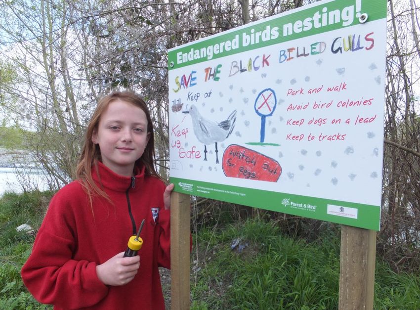
Ashburton River/Hakatere shorebird habitat management plan

Nikki McArthur and Mike Bell
Wildlife Management International Ltd
PO Box 607
Blenheim 7240
New Zealand
www.wmil.co.nz

This report was prepared by Wildlife Management International Limited for Environment Canterbury
as fulfilment of the Contract of Services No. 490-16/17 dated 1st June 2016.

31st August 2016

Citation:
This report should be cited as:
McArthur, N. and Bell, M. 2016. Ashburton River/Hakatere shorebird habitat management plan. Client
report prepared for Environment Canterbury. Wildlife Management International Ltd, Blenheim.
All photographs in this Report are copyright © WMIL unless otherwise credited, in which case the
person or organization credited is the copyright holder.
Cover image: Black-billed gull (Larus bulleri) sitting on a nest. Image courtesy of Steve Attwood,
Auldwood Photography, www.flickr.com/photos/stevex2/.
EXECUTIVE SUMMARY

The Ashburton River/Hakatere is considered to be one of the most important braided rivers in
Canterbury for birdlife, supporting nationally-significant populations of a number of Nationally
Threatened or ‘At Risk’ shorebird species.
A number of groups and agencies, including Environment Canterbury, the Department of
Conservation, Forest & Bird and Braid have implemented local-scale management actions to improve
the state of the river and its bird values. These efforts have met with local success, including raising
greater awareness of the value of the large black-billed gull colony near the SH1 bridge, and reducing
the impacts of woody weeds and mammalian predators on a particularly high-value reach of the river
near Hakatere.
These stakeholders have agreed to a need to create an overarching management plan for the
Ashburton River/Hakatere, to better prioritise and coordinate these management actions, and to
identify additional threats that need to be addressed with management.
An analysis of shorebird count data collected annually since 1981 has led to the identification of three
reaches of the Ashburton River/Hakatere that support particularly high numbers of shorebirds during
the breeding season (August – February). Furthermore, the Ashburton River mouth has emerged as a
significant year-round habitat for the highest diversity of birds recorded anywhere in the Ashburton
District.
This management plan proposes a series of management actions focussed on reducing the impacts of
a range of the threats operating on these key reaches of river. These actions include a combination
of management work currently underway, and new initiatives for which additional funding and
resources will need to be found.
A common message received from all of the stakeholders that provided input into this plan was that
the current high rates of water abstraction from the Ashburton River/Hakatere is likely to be directly
causing, or exacerbating the negative impacts that woody weeds, pest animals and people are having
on the river’s shorebird values. For this reason, it is hoped that the preparation of this management
plan does not take any urgency away from the need to increase the minimum environmental flow
limits set out for the Ashburton River/Hakatere in the Canterbury Land and Water Regional Plan.
This plan has a seven-year operational lifespan, and it is recommended that it be reviewed and
updated in July 2023 following the implementation of the first increased environmental minimum flow
limit.

                                                                                                       i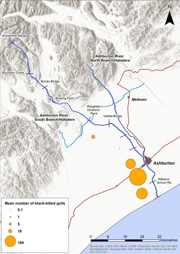
Ashburton River/Hakatere shorebird habitat management plan
1. INTRODUCTION
1.1 Purpose and scope of this plan
This Ashburton River/ Hakatere river bird management plan has been prepared as an outcome
of discussions held between Environment Canterbury, the Department of Conservation and
the Ashburton Branch of Forest & Bird.
The purpose of the plan is to facilitate the coordination of management activities aimed at
improving habitat quality for the shorebirds of the Ashburton River/Hakatere; to guide the
prioritisation of management actions and existing funding; and to support applications for
further funding to resource management actions. As such, all of the management and
monitoring actions outlined in this plan should be considered as recommendations. Prior to
the implementation of any of these actions, all relevant or affected stakeholders shall be
consulted and be given the opportunity to have input into the planning and implementation
of these actions.
It is proposed that an Ashburton River/Hakatere Management Group be established to
oversee the implementation and review of this management plan. This management group
shall include representatives from key stakeholder groups, including but not restricted to:
Environment Canterbury, Ashburton District Council, the Department of Conservation, Forest
& Bird, Fish & Game, Arowhenua Rūnanga and the Mid-Canterbury Four Wheel Drive Club.
Environment Canterbury has been nominated as the agency responsible for convening the
Ashburton River/Hakatere Management Group and coordinating the implementation of this
management plan.
This plan has an initial seven year operational lifespan from October 2016 to July 2023, and is
due to be reviewed and renewed in 2023 following the implementation of the 6000 L/sec
minimum environmental flow limit set in the Canterbury Land and Water Regional Plan (ECan,
2015).
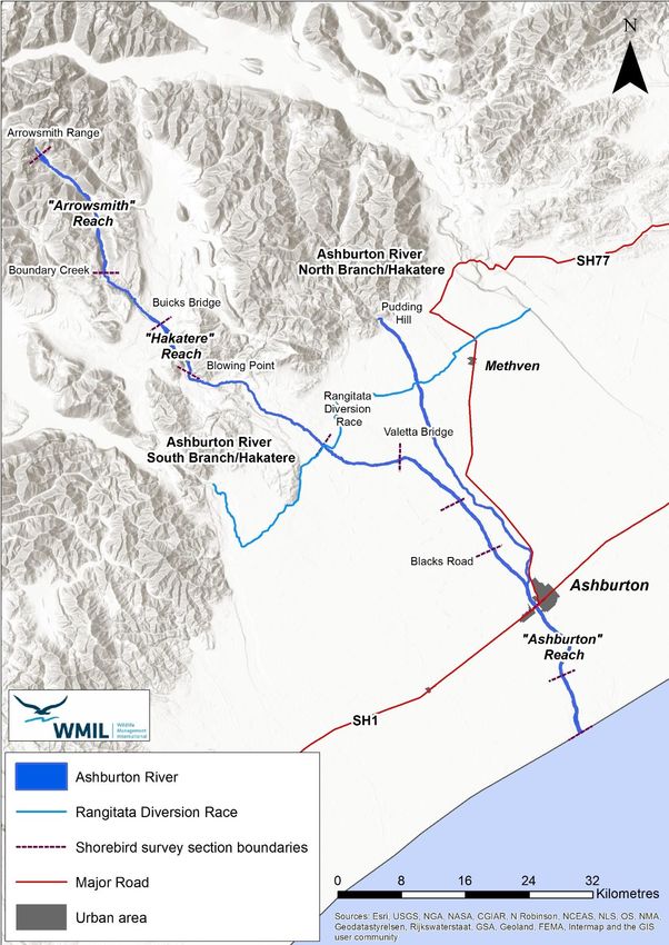
The geographic extent of the management plan is the bed of the Ashburton River/Hakatere
from the Coastal Marine Area (therefore including the Ashburton River mouth), to the base of
the Arrowsmith Range on the Ashburton River/Hakatere South Branch and the Pudding Hill
Stream confluence on the Ashburton River/Hakatere North Branch (see Figure 1.1).
McArthur, N. and Bell, M. 2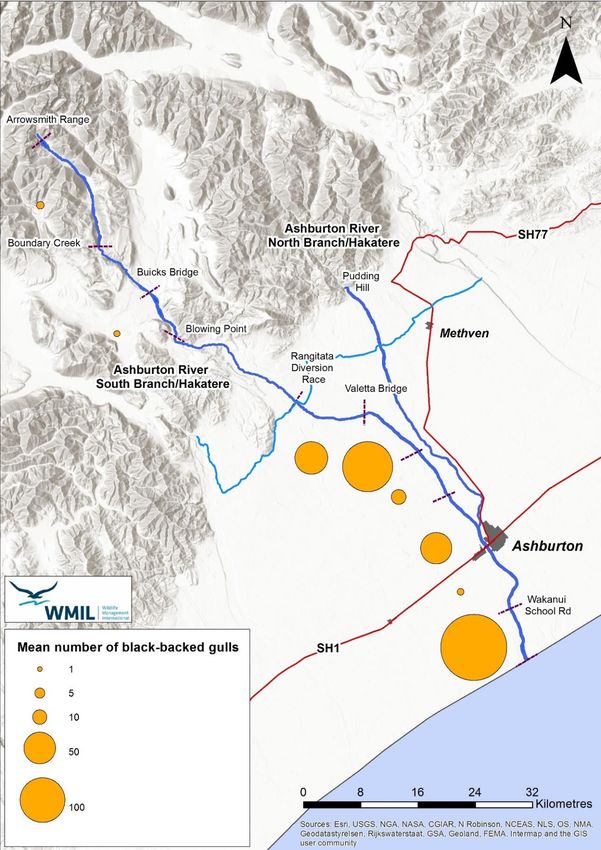
Ashburton River/Hakatere shorebird habitat management plan

         Figure 1.1: Map of the Ashburton River/Hakatere, showing the geographic scope of this
         management plan.

McArthur, N. and Bell, M.                                                                             3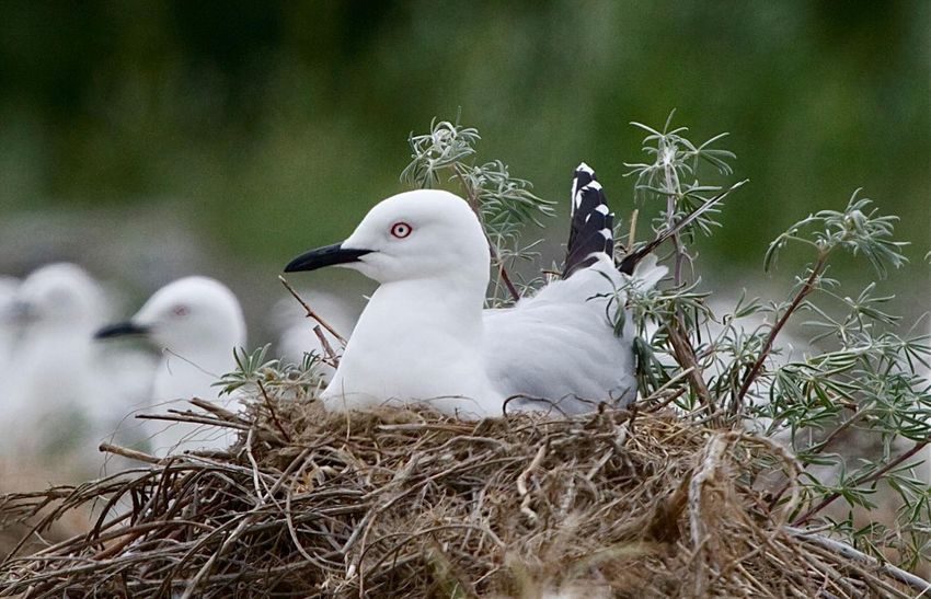
Ashburton River/Hakatere shorebird habitat management plan

         1.2 Shorebird values of the Ashburton River/Hakatere

         The Ashburton River/Hakatere is considered to be one of the most important braided rivers
         in the Canterbury region for birdlife, supporting nationally- and regionally-significant
         populations of black-fronted terns (Chlidonias albostriatus), black-billed gulls (Larus bulleri),
         banded dotterels (Charadrius bicinctus), black-fronted dotterels (Elseyornis melanops), wrybill
         (Anarhynchus frontalis), South Island pied oystercatchers (Haematopus finschi), pied stilts
         (Himantopus himantopus) and black-backed gulls (Larus dominicanus; O’Donnell, 1992). A
         total of 75 bird species have been recorded on the Ashburton River/Hakatere since 1981, 31%
         of which (23 species) are ranked as Nationally Threatened or ‘At Risk’ under the New Zealand
         Threat Classification System (Appendix 1).

         The Ashburton River/Hakatere has been identified as an Important Bird Area (IBA) by Birdlife
         International and Forest & Bird. This is based on the presence of five indigenous bird species
         with local population sizes that trigger IBA criteria, including black-billed gull, black-fronted
         tern, wrybill, Australasian bittern (Botaurus poiciloptilus) and spotted shag (Sticticarbo
         punctatus; Forest & Bird, 2016).

         The Ashburton River/Hakatere and its associated lakes and wetlands have long been an
         important landscape and food basket for Ngāi Tahu. For Ngāi Tahu, water is a taonga left by
         the ancestors to provide and sustain life. All the waterways, their associated tributaries,
         wetlands and springs are considered significant resources, of cultural, spiritual and historical
         importance to Ngāi Tahu (ECan, 2011). Three Rūnanga consider the zone part of their takiwā,
         namely Arowhenua Rūnanga, Taumutu Rūnanga and Ngāi Tūāhuriri Rūnanga (Ashburton Zone
         Committee, 2015). In earlier times, the eggs of karoro (black-backed gulls), tarāpuka (black-
         billed gulls) and kakīānau (black swans) were harvested for food, as were moulting pārera
         (grey ducks). Native fish species including īnanga (Galaxias maculatus), kanakana (lamprey;
         Geotria australis) and tuna (freshwater eels; Anguilla spp.) were also important food
         resources, and continue to be harvested by members of the local Rūnanga and the wider local
         community (John Henry, personal communication).

         The South Branch of the Ashburton River/Hakatere supports much larger numbers of
         shorebirds than the North Branch of the river (O’Donnell, 1992). On the South Branch, three
         reaches of river support a particularly high diversity and/or density of shorebirds. The 17 km
         “Arrowsmith Reach”, from the base of the Arrowsmith Range downstream to the Boundary
         Creek confluence supports relatively high numbers of banded dotterels, black-fronted terns
         and New Zealand pipits (Anthus novaeseelandiae; O’Donnell, unpublished data). Further
         downstream, the 9 km “Hakatere Reach” also supports relatively high numbers of banded
         dotterels, black-fronted terns and New Zealand pipits, together with a small number of wrybill
         (Grove, 2005; Cochrane, 2015; O’Donnell, unpublished data). Downstream from the
         “Hakatere Reach” the river becomes much more channelised and shorebirds become either
         rare or absent. Shorebird numbers begin to increase again downstream from the Rangitata
         Diversion Race, with particularly high densities of banded dotterels, pied stilts, SI pied
         oystercatchers and black-fronted terns found on the 27 km “Ashburton Reach” between
         Blacks Road and the coast. The 18 km section of this reach between the SH1 Bridge and the
         coast also provides habitat for the majority of the black-fronted dotterels found on the
         Ashburton River/Hakatere (Figure 1.2; O’Donnell, unpublished data).

         An outstanding feature of the “Ashburton Reach” of the river is the large number of Nationally
         Critical black-billed gulls that typically use this reach as breeding habitat during the summer

McArthur, N. and Bell, M.                                                                                   4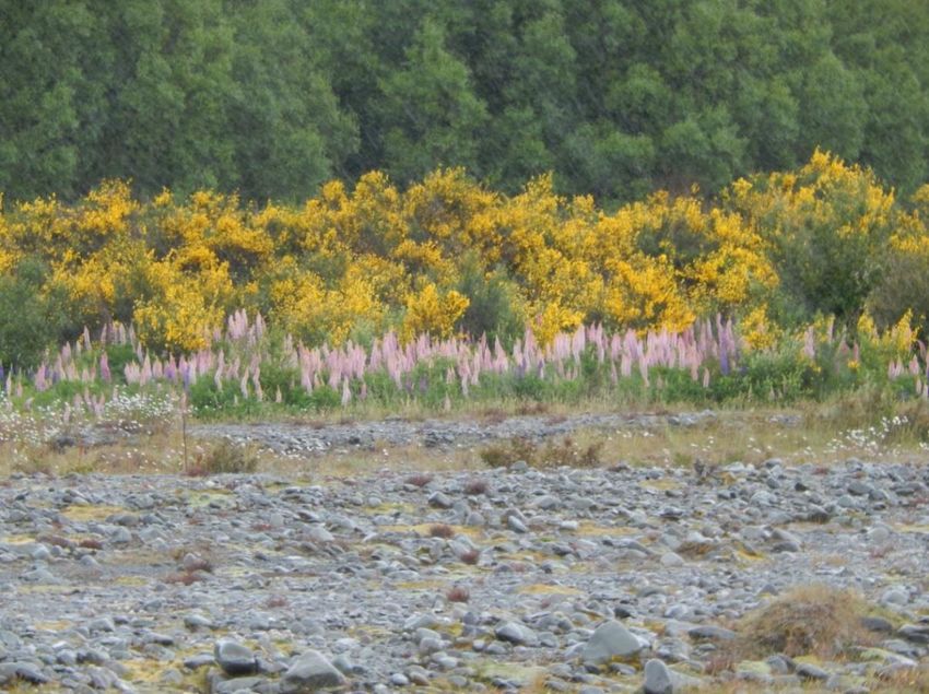
Ashburton River/Hakatere shorebird habitat management plan

         months (Figure 1.3). Historically, the Ashburton River/Hakatere South Branch has had some
         of the highest counts of black-billed gulls of any braided river surveyed, with just under 11,000
         birds recorded in 1986 and counts of over 10,000 birds recorded in 1982, 1984 and 1987
         (O’Donnell, 1992). Gull numbers have declined in more recent years, however breeding
         colonies of several thousand birds still typically establish each summer, usually either
         immediately upstream, or downstream of the SH1 Bridge (Schmechel, 2008; McClellan, 2015;
         Mischler & Bell, 2016a; O’Donnell, unpublished data). During the 2014/15 breeding season,
         a colony of 9,545 black-billed gulls was recorded on the lower Ashburton/Hakatere River, the
         largest colony recorded in the Canterbury region that year (McClellan, 2015). During the
         2015/16 breeding season, two much smaller colonies comprised of 1,198 and 203 birds were
         situated near the SH1 Bridge and at the Ashburton River mouth respectively (Mischler & Bell,
         2016a). This sudden drop in gull numbers between 2014/15 and 2015/16 is thought to be due
         to a large number of gulls relocating from the Ashburton River/Hakatere to the Rangitata River
         mouth during the second year, possibly in response to extensive woody weed growth in the
         bed of the lower Ashburton River/Hakatere (Mischler & Bell, 2016a).

         The Ashburton River mouth provides important year-round habitat for a large number of
         shorebird and waterfowl species, with more bird species having been recorded at this site
         than at any other location in the Ashburton District (Andrew Crossland, unpublished data). An
         outstanding feature of the river mouth is the very large concentrations of spotted shags that
         roost on the shingle spit at the mouth of the river during autumn and winter. Flocks of up to
         6000 spotted shags have been observed roosting at the river mouth (Crossland, 2016), most
         likely comprised of juvenile and post-breeding adult birds from the nearby Banks Peninsula
         population (Doherty & Bräger, 1997). The river mouth and shingle spit also provides
         important breeding habitat for black-billed gulls (Mischler, 2016) and banded dotterels during
         summer months. During autumn and winter, the river mouth and shingle spit also provides
         foraging and roosting habitat for a range of coastal and freshwater bird species, including
         black shags (Phalacrocorax carbo), SI pied oystercatchers, variable oystercatchers
         (Haematopus unicolor), red-billed gulls (Larus novaehollandiae), white-fronted terns (Sterna
         striata), black-fronted terns and Caspian terns (Hydroprogne caspia; eBird, 2002).

         Between 1981 and 2015 there have been significant declines in the numbers of black-fronted
         terns, black-billed gulls, banded dotterels, SI pied oystercatchers and pied stilts counted each
         summer on the Ashburton River/Hakatere South Branch (O’Donnell, 1992; O’Donnell,
         unpublished data). These declines are likely to have occurred due to a combination of ongoing
         habitat loss and loss of habitat quality resulting from declining mean low flows, the
         encroachment of woody weeds into open gravel habitats and depredation by mammalian
         predators (O’Donnell, 1992). In more recent years, these declines have been at least partially
         offset by the local recovery of banded dotterels, black-fronted terns and wrybill in the
         “Hakatere Reach” of the Ashburton River/Hakatere South Branch, likely a consequence of the
         intensive pest animal and weed control work that has been carried out by Environment
         Canterbury and the Department of Conservation along this stretch of river and in the
         surrounding landscape since 2003 (Cochrane, 2015; O’Donnell, unpublished data).

         In contrast to the ongoing declines being observed in a number of these locally-breeding
         shorebird species, annual counts of black-fronted dotterels have steadily increased since
         1981. Black-fronted dotterels are a recent coloniser to New Zealand having first been
         recorded in Hawkes Bay in 1954 (Brathwaite, 1956). This increase in the number of black-
         fronted dotterels observed on the Ashburton River/Hakatere is likely a consequence of the
         ongoing range expansion of this species in New Zealand in recent decades (Robertson et al,
         2007). At present, black-fronted dotterels are mainly restricted to the “Ashburton Reach” of

McArthur, N. and Bell, M.                                                                                   5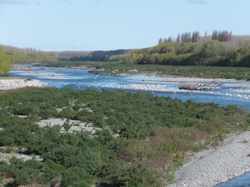
Ashburton River/Hakatere shorebird habitat management plan
the Ashburton River/Hakatere South Branch, but are steadily expanding their distribution up
river, having now been recorded as far upstream as the Valetta Bridge (O’Donnell,
unpublished data).
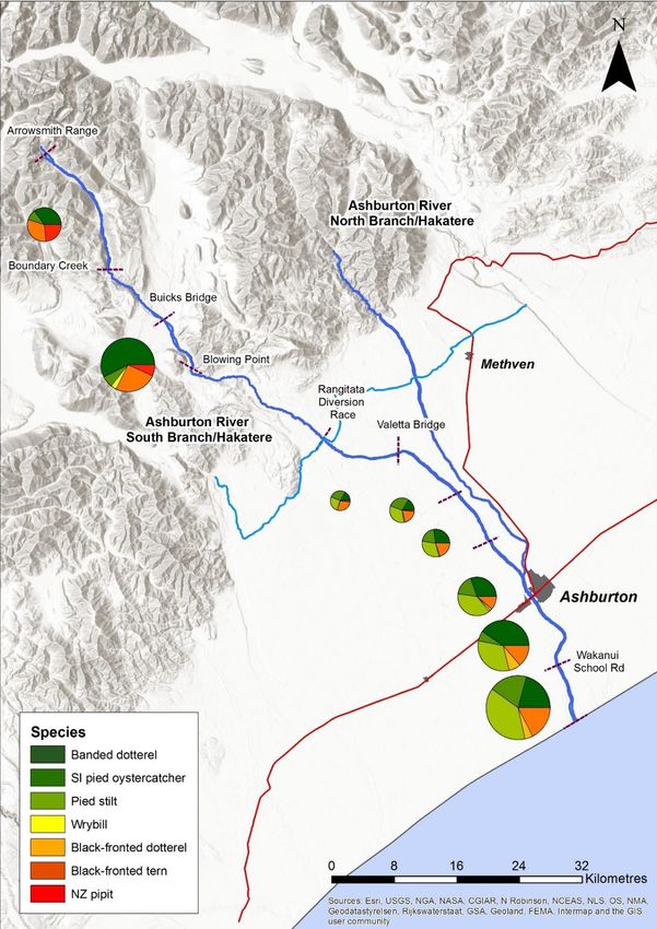
Figure 1.2: Mean relative abundance of shorebirds (excluding gulls) along the Ashburton
River/Hakatere South Branch between 2006 and 2015 Source: Colin O’Donnell, unpublished
data.
McArthur, N. and Bell, M. 6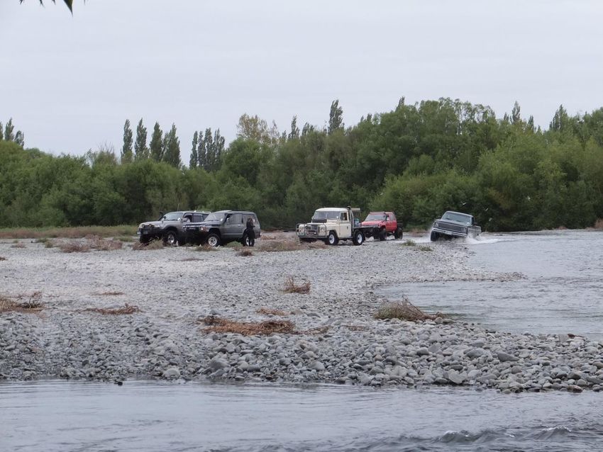
Ashburton River/Hakatere shorebird habitat management plan

         Figure 1.3: Mean annual counts of black-billed gulls along the Ashburton River/Hakatere
         South Branch between 2006 and 2015. Source: Colin O’Donnell, unpublished data.

McArthur, N. and Bell, M.                                                                              7
Ashburton River/Hakatere shorebird habitat management plan

         1.3 Threats to the shorebird values of the Ashburton River/Hakatere

         Water abstraction
         The maintenance of natural flow regimes on braided rivers has long been recognised as being
         essential for maintaining high quality feeding and breeding habitat for shorebirds (Hughey,
         1985, 1997, 1998; Hughey et al, 1987). A high diversity of microhabitats, including both
         shallow and deep water, runs and riffles of intermediate depth and dry gravel beaches and
         islands of different heights is needed to maintain the full diversity of riverbed-nesting birds on
         braided rivers (Hughey, 1985; Hughey et al, 1989, Rebergen, 2011 and 2012).
         Abstraction of water from rivers and the consequent reduction in mean and peak flows
         reduces the size and number of small channels and gravel islands in rivers and reduces the
         total area of aquatic feeding habitat for birds (Bowden et al, 1982; Robertson et al, 1983;
         Hughey, 1987). Furthermore, braided rivers are naturally unstable habitats, and it’s this
         feature that naturally limits the establishment of woody vegetation and allows the
         maintenance of the large areas of open gravel habitats required by riverbed-nesting
         shorebirds. The lower and less variable flows resulting from water abstraction can reduce the
         natural erosion and scouring of the riverbed, leading to dramatic increases in woody weed
         growth such as that seen on the lower Ashburton River/Hakatere within the last 30 years
         (Miall, 1977; O’Donnell 1992). In extreme situations, if flows are reduced to the extent that
         channels dry up (as can occur in the lower reaches of the Ashburton River/Hakatere North
         Branch) there will be an almost total loss of local shorebird populations (e.g. Maloney 1999).
         The Ashburton Zone Implementation Programme clearly identifies that the authorised takes
         from the Ashburton River/Hakatere are so great that the river is being placed under severe
         pressure (ECan, 2011). It states that “there is widespread recognition…of the pressure the
         river is under from reduced flows due to significant consumptive use and the impacts of
         changing land use…” According to the ZIP, both summer and winter flows in the Ashburton
         River/Hakatere are over-allocated. Summer allocations currently represent 191% of the
         Seven Day Mean Annual Low Flow (7DMALF) and winter allocations represent 133% of the
         7DMALF (ECan, 2011).
         These high rates of water abstraction are likely to be exacerbating the impacts of other threats
         to shorebird values mentioned below. For instance, O’Donnell (2000) states that “river flows
         and [woody] weed problems appear to be closely linked”, due to the fact that lower flows
         create more stable gravel habitats into which woody weeds can invade more easily. Similarly,
         lower river flows can reduce the number and area of gravel islands that provide comparatively
         safe nesting habitat for shorebirds due to being less accessible to mammalian predators (Bell
         & McArthur, 2016).

         Flood protection management activities
         A number of the activities carried out by local authorities to manage the risk of flooding can
         have detrimental impacts on shorebirds and their habitats. Disturbance of dry gravel habitats
         during woody weed removal, gravel extraction, gravel ripping or contouring activities carried
         out during the breeding season can lead to the local destruction of nests and chicks, reducing
         the productivity of shorebird populations (Cameron, 2013 & 2015; McArthur et al, 2015). The
         construction of stopbanks, rock groynes, willow planting, gravel island removal and channel
         straightening can increase river channelisation and reduce habitat quality for shorebirds
         (O’Donnell, 2000; Rebergen 2011 & 2012).

McArthur, N. and Bell, M.                                                                                   8
Ashburton River/Hakatere shorebird habitat management plan
Conversely, some of these activities can have positive impacts on locally-breeding shorebirds
provided that local losses of nests, eggs and chicks are minimised. In the absence of large,
regular floods, the mechanical disturbance of dry gravels during gravel extraction, gravel
ripping or contouring activities can help reduce woody weed encroachment and maintain
open habitats for shorebirds. On the Ruamahanga River and its tributaries, these activities
appear to have helped to maintain stable or increasing populations of banded dotterels, black-
fronted dotterels and black-billed gulls over the past 30 years, during which time shorebird
populations on nearby rivers not subject to flood protection activities have declined
(Rebergen, 2011; 2012; McArthur et al, 2015).
Environment Canterbury and Ashburton District Council have statutory responsibilities under
the Resource Management Act (1991) for the management of flood risks from the Ashburton
River/Hakatere. Measures taken to manage flood risks posed by the river include the
construction of stopbanks, the planting of willows to protect and stabilise river banks and
gravel extraction, woody weed control and channel straightening to streamline flows and to
maintain the flood-bearing capacity of the active riverbed (Boyle, 2012).
Recreational use of the riverbed
Unintentional disturbance by people and vehicles can cause localised losses of eggs, chicks
and adult birds during the breeding season (O’Donnell & Moore, 1983; Robertson et al, 1983),
Similarly, the prolonged or repeated disturbance of roosting birds can cause them to abandon
traditional habitats, increasing competition for remaining disturbance-free habitats
(Woodley, 2012). The effects of prolonged or repeated disturbance of birds is difficult to
quantify, however by increasing energy expenditure and/or reducing time spent roosting and
foraging, higher rates of disturbance may reduce the survival and productivity of affected
birds, potentially contributing to population declines (Pfister et al, 1992; Lord et al, 1997).
On the Ashburton River/Hakatere, disturbance impacts are likely to occur mainly during the
shorebird breeding season (August – February), as the majority of the shorebirds that breed
on the Ashburton River/Hakatere migrate to coastal sites elsewhere during the non-breeding
season (Heather & Robertson, 2015). Disturbance impacts are likely to be highest closer to
urban centres and in the vicinity of river access points, so the “Ashburton Reach”, with its
proximity to Ashburton Township and multiple legal access points to the river is particularly
at risk to disturbance impacts (Figure 1.4).
The Ashburton River mouth, and particularly the shingle spit is at risk from disturbance caused
by 4WDs, fishers and other recreational users all year round. The shingle spit provides
important breeding and roosting habitat for a large variety of shorebird species year-round,
and is a particularly important roosting sites for large numbers of spotted shags.
McArthur, N. and Bell, M. 9Ashburton River/Hakatere shorebird habitat management plan
Figure 1.4: Convoy of 4WD vehicles driving through a black-fronted tern colony the lower
Ashburton River/Hakatere, October 2015. Adult black-fronted terns can be seen flying
around the rear (right hand) vehicle. In this case the disturbance was unintentional, the
occupants of the vehicles believed that the birds were nesting in the lupins, so drove on the
open shingle in an attempt to avoid damaging nests. Source: Forest & Bird.
Vandalism and illegal hunting
Vandalism and the illegal hunting of shorebirds can cause catastrophic losses of adult birds,
eggs and chicks, leading to sudden and drastic local population declines. Most of New
Zealand’s shorebird species are relatively long-lived with comparatively low reproductive
rates (Dowding & Murphy, 2001; Heather & Robertson, 2015). Due to these life history traits
it can take many years, or decades for shorebird populations to recover from sudden,
catastrophic mortality events.
Some species are particularly vulnerable to vandalism and hunting due to negative public
perception and a history of persecution (Woodley, 2012). Gulls are particularly at risk, due to
their ubiquitous distribution and scavenging behaviours. An added complication is that
relatively few people can reliably distinguish between black-billed gulls (Nationally Critical,
and absolutely protected under the Wildlife Act, 1953) and black-backed gulls (Not
Threatened, and one of our few native species that is not legally protected). Shags are another
group of birds that have a history of illegal persecution, due to an erroneous assumption that
they compete with fishers for commercial, recreational and sport fish (Dickinson, 1951).
On the lower Ashburton River/Hakatere, two shorebird species are particularly at risk of
vandalism or illegal hunting. The large black-billed gull colony that typically establishes each
summer in the vicinity of the SH1 Bridge is a very large and conspicuous feature and has
attracted the attention of vandals in the past. In November 2008, a vehicle was intentionally
McArthur, N. and Bell, M. 10Ashburton River/Hakatere shorebird habitat management plan
driven through this colony, causing the deaths of 110 adults and destroying an unknown
number of eggs and chicks. (Schmechel, 2008). Following a similar incident in November 2012,
a man was prosecuted and sentenced to two months’ imprisonment for driving his vehicle
into the colony, destroying an unknown number of nests and eggs (Ashburton Guardian,
2013).
The very large concentrations of spotted shags that roost on the shingle spit at the Ashburton
River mouth is similarly at risk. Despite the fact that spotted shags feed almost exclusively at
sea and forage up to 15km offshore (Heather & Robertson, 2015), some members of the local
community are calling for the spotted shags at the Ashburton River mouth to be culled, due
to a belief that they’re competing with recreational fishers for freshwater fish and mahinga
kai species (John Henry, personal communication). In January 2016, over 50 birds including
16 black-billed gulls, four white fronted terns, one SI pied oystercatcher and one spotted shag
were illegally shot at the Ashburton River mouth (Edith Smith, personal communication).
Woody weeds
Introduced weeds such as broom (Cytisus scoparius), gorse (Ulex europaeus), Russell lupin
(Lupinus polyphyllus), sweet briar (Rosa rubiginosa) and willow (Salix spp.) are particularly
invasive in braided river habitats and pose a significant threat to shorebird populations
(O’Donnell & Moore 1983; Brown 1999). Woody weeds reduce the total area of open gravel
habitats available to shorebirds and are also likely to increase the channelisation of the river,
leading to the loss of minor braids and gravel islands which provide particularly high quality
shorebird foraging and nesting habitat. Furthermore, dense stands of woody weeds provide
shelter and cover for mammalian predators, so likely contribute to higher depredation rates
on breeding shorebirds (O’Donnell & Moore, 1983; Robertson et al, 1983; O’Donnell 1992;
Hughey & Warren 1997 and Rebergen et al, 1998).
The two upper reaches of the Ashburton River/Hakatere South Branch that currently support
high numbers of shorebirds (the “Arrowsmith” and “Hakatere” reaches described above) are
both relatively weed-free at present, however the Hakatere Reach is now being encroached
upon by broom, sweet briar, Russell lupin, yellow tree lupin, false tamarisk (Myricaria
germanica) and grey willow (Salix cinerea; Figure 1.5).
On the lower reaches of the Ashburton River/Hakatere, particularly the “Ashburton Reach”
described above, weed encroachment has been steadily worsening since the early 1980s.
O’Donnell (1992) observed that there had been a “considerable increase in the extent and
encroachment of introduced shrubs, particularly broom, gorse and…willows” on the river
between 1981 and 1990. He also noted that there was a strong relationship between the
extent of woody weed encroachment observed and the total abundance of shorebirds
counted along the river. Since the early 1980s, shorebird numbers have steadily declined as
weed encroachment has worsened, although shorebird numbers temporarily bounced back
following major flood events that cleared woody vegetation from large areas of riverbed. Such
events only provided temporary improvement in habitat quality however, as woody weeds
typically re-colonised these clear areas of riverbed within 3-4 seasons following a major flood
event. Based on these observations, O’Donnell (1992) concluded that “if the wildlife values
are to be maintained [on the Ashburton River/Hakatere], then weed control is essential.”
Woody weed growth within Ashburton Reach has been particularly severe over the past 2-3
years, with the majority of gravel beaches and islands now covered in dense thickets of broom
and yellow tree lupin (L. arboreus) (Figure 1.6). This weed growth has led to rapid, local
declines in several shorebird species, and likely caused a large number of black-billed gulls to
McArthur, N. and Bell, M. 11Ashburton River/Hakatere shorebird habitat management plan
abandon their traditional nesting site near the SH1 Bridge last summer, in favour of nesting at
the Rangitata River mouth (O’Donnell, unpublished data; Mischler & Bell, 2016a).
McArthur, N. and Bell, M. 12Ashburton River/Hakatere shorebird habitat management plan
Figure 1.5: Broom and Russell lupin infestation on the true left bank of the “Hakatere Reach”
of the Ashburton River/Hakatere South Branch. Source: Cochrane (2015).
Figure 1.6: Extensive tree lupin infestation and prospecting black-billed gulls on the
Ashburton River/Hakatere near the SH1 Bridge in late September 2015. Source: Edith
Smith/Forest & Bird.
McArthur, N. and Bell, M. 13Ashburton River/Hakatere shorebird habitat management plan
Mammalian predators
There is now a very large body of evidence demonstrating that introduced mammalian
predators including feral cats (Felis catus), ferrets (Mustela furo), stoats (M. erminea) and
hedgehogs (Erinaceus europaeus) have a major impact on the survival and productivity of
riverbed-nesting shorebirds and are contributing to ongoing population declines of several
species. Species such as wrybill, banded dotterels and black-fronted terns are particularly
vulnerable to predation (e.g. Rebergen et al, 1998; Dowding & Murphy, 2001; Sanders &
Maloney, 2002; Bell & McArthur, 2016; Figure 1.7).
Figure 1.7: A feral cat (A) and a hedgehog (B) preying on black-fronted tern nests on the
Upper Clarence River, November 2015. Source: Bell & McArthur, (2016).
All of these predator species are present and widespread on the Ashburton River/Hakatere,
and a regularly trapped in predator control operations underway in both the Hakatere and
Ashburton Reaches of the river (Cochrane, 2015). Local increases in the abundance of
shorebirds in the Hakatere Reach since 2003 indicates that the trapping programme on this
part of the river is succeeding in reducing depredation rates by mammalian predators
(O’Donnell, unpublished data). However, predators are likely to be contributing to the
ongoing declines in shorebird numbers being observed from the Valetta Bridge downstream
to the sea.
Black-backed gulls
There is a growing body of evidence demonstrating that black-backed gulls can be significant
predators of other shorebird species, including black-billed gulls and black-fronted terns.
Impacts are likely to be highest when large numbers of black-backed gulls are co-existing with
these more vulnerable species, and particularly when nesting colonies are situated in close
proximity (Mischler & Bell, 2016b). Although black-backed gulls are a native species, they
have benefited substantially from the human settlement of New Zealand, and their numbers
are now substantially higher than at any time in the past (Heather & Robertson, 2015). As a
result, black-backed gulls are one of the few native bird species not afforded any level of
protection under the Wildlife Act (Miskelly, 2013).
The Ashburton River/Hakatere South Branch supports a very large breeding population of
black-backed gulls. Numbers are relatively low in both the Arrowsmith and Hakatere Reaches,
the latter being a consequence of culling operations carried out by Environment Canterbury
(Grove, 2005). Black-backed gull numbers continue to be very high on the lower reaches of
the Ashburton River/Hakatere from the Rangitata Diversion Race downstream, particularly
McArthur, N. and Bell, M. 14Ashburton River/Hakatere shorebird habitat management plan
the reaches between Valetta Bridge and Shearers Road and the “Ashburton Reach” between
Blacks Road and the sea (Figure 1.8). During summer months, breeding colonies comprising
up to 2500 birds have been recorded on these lower reaches of the river (O’Donnell,
unpublished data).
McArthur, N. and Bell, M. 15Ashburton River/Hakatere shorebird habitat management plan
Figure 1.8: Mean annual counts of black-backed gulls along the Ashburton River/Hakatere
South Branch between 2006 and 2015. Source: Colin O’Donnell, unpublished data.
McArthur, N. and Bell, M. 16Ashburton River/Hakatere shorebird habitat management plan
Table 1.1 below summarises the key threats impacting the bird values of the Ashburton
River/Hakatere that are described above, and identifies which reaches of river are being
affected by each threat. The codes alongside each threat correspond to the management
objectives listed in Table 2.1, which in turn correspond to the management activities listed in
the Operational Plan (Table 3.1). These codes are used to ensure that each management
action taken is targeted at reducing or eliminating one or more specific threats that have been
identified.
Many of the threats identified here can, and do interact with each other. For example, higher
rates of water abstraction can increase the rate of woody weed encroachment into the open
gravel habitats required by nesting shorebirds. Furthermore, the effects of these threats on
local shorebird populations can be both direct (e.g. vandalism of black-billed gull colonies
causing local losses of adults, eggs and chicks) and indirect (e.g. woody weeds providing
improved habitat for mammalian predators and leading to an increase in depredation rates
on shorebirds). Figure 1.9 below summarises the interactions between the various threats
summarised in Table 1.1, and how each threat directly or indirectly impacts local shorebird
populations.
McArthur, N. and Bell, M. 17Ashburton River/Hakatere shorebird habitat management plan
Table 1.1: Key threats to river bird values on the Ashburton River/Hakatere (SB = Ashburton
River/Hakatere South Branch; NB = Ashburton River/Hakatere North Branch)
Threat code Threat and impact on river bird values Affected area(s)
Human activities
HA-1* High levels of water abstraction is reducing mean water flows in the river, SB: From the Inverary
likely increasing the rate of woody weed encroachment in open gravel Bridge to the sea;
habitats and improving predators’ ability to access and depredate
NB: From Pudding Hill
shorebird eggs, chicks and adult birds. Low water flows are also likely to be
to the NB/SB
improving 4WD and foot access in the riverbed, leading to higher rates of
confluence
human disturbance of nesting shorebirds.
HA-2* ECan flood protection management activities, including aerial spraying and SB: From the Inverary
mechanical removal of weeds, gravel extraction, stopbank and rock groyne Bridge to the sea.
construction and willow planting has the potential to disturb nesting
NB: From Pudding Hill
shorebirds when activities are carried out during the breeding season. The
to the NB/SB
cumulative effects of these activities may also lead to greater
confluence.
channelization of the riverbed over time, reducing the overall extent and
quality of shorebird habitat on the river.
HA-3 Recreational users, including 4WDs, fishers, dog-walkers and bird-watchers Entire river.
have the potential to disturb shorebirds, resulting in localised losses of eggs
and chicks and lower annual productivity.
HA-4 Intentional vandalism and illegal hunting or culling of local bird populations From SH1 road bridge
can result in catastrophic losses of adults, chicks and eggs. Species at to river mouth.
particular risk include black-billed gulls and spotted shags.
Pest plants
PP-1 Woody weeds (primarily broom, gorse, lupin and willow spp.) are SB: From Buicks Bridge
encroaching on the riverbed and reducing the area of open gravel habitats to the sea
used by locally-breeding shorebirds. Woody weeds also provide improved
NB: From Pudding Hill
habitat and cover for mammalian predators.
to the NB/SB
confluence.
Pest animals
PA-1 Introduced mammalian predators (principally possums, mustelids, cats and Entire river
hedgehogs) are reducing the survival and productivity of locally-breeding
shorebirds by preying on eggs, chicks and adult birds.
PA-2 Native black-backed gulls are likely to be reducing the productivity of other SB: From the Valetta
(threatened) shorebird species by preying on eggs and chicks. The presence Bridge to the sea.
of large black-backed gull colonies on the river may also the area of habitat
available to these more threatened shorebird species due to competitive
exclusion and predator avoidance behaviours.
* Any threats marked with an asterisk are not addressed by actions in this management plan. In the case of HA-1 above, this
threat is being addressed in other planning documents, namely the Canterbury Water Management Strategy, Ashburton
Zone Implementation Programme and Canterbury Land and Water Regional Plan which together provide a framework for
addressing water abstraction issues in the Ashburton River/Hakatere catchment (CWMS, 2010; ECan 2011; ECan, 2015). In
the case of HA-2, this threat is being addressed in the Code of Practice documents governing activities carried out by ECan
for the purposes of flood management (ECan 2015b; 2015c). However, in order to effectively manage the shorebirds of the
Ashburton River/Hakatere, it is important to be aware of all existing threats to the bird values of the river, hence the inclusion
of these threats in the table above.
McArthur, N. and Bell, M. 18Ashburton River/Hakatere shorebird habitat management plan
Figure 1.9: Interactions and effects of key threats to the shorebird values of the Ashburton River/Hakatere.
McArthur, N. and Bell, M. 19Ashburton River/Hakatere shorebird habitat management plan
1.4 Landowners and stakeholders
Environment Canterbury Regional Council
The roles and functions of Environment Canterbury Regional Council (ECan) are set out by the
Local Government Act (2002). Among these functions, ECan is responsible for managing the
effects of using freshwater, land, air and coastal waters, by developing regional policy
statements and through the issuing of consents under the Resource Management Act (1991).
ECan is also charged with managing rivers in the Canterbury region in order to mitigate soil
erosion and for flood control under the Soil Conservation and Rivers Control Act (1941).
Regional Councils have a statutory requirement to take into account a range of natural and
cultural values under the Resource Management Act. These include recognising and providing
for the protection of significant habitats of indigenous fauna from inappropriate subdivision,
use and development (Section 6c) and recognising the relationship of Māori and their culture
with taonga (Section 6e). There is also a requirement to have a particular regard to the
intrinsic values of ecosystems (Section 7d).
The broad policy direction for ECan is described in the Canterbury Regional Policy Statement
(ECan, 2013), and includes:
Chapter 8, Objective 3, Policy 4: Areas of indigenous vegetation and habitats of
indigenous fauna…should be protected from adverse effects
Chapter 9, Objective 1, Policy 1: Flow regimes and water levels should be set to
protect basic instream values including ecological values
Chapter 10, Objective 1, Policy 1: Land use activities should avoid causing significant
adverse effects on the significant habitats of indigenous flora and fauna within the
beds of rivers and lakes and their margins.
Environment Canterbury is responsible for flood management activities on the lower reaches
of the Ashburton River/Hakatere, including woody weed control, the construction and
maintenance of stopbanks and groynes, riparian willow planting and gravel extraction. ECan’s
Flood Protection staff have indicated a willingness to assist with some of the management
actions listed in this plan, including providing technical support regarding the creation and
maintenance of gravel islands to provide safe nesting habitat for shorebirds.
Environment Canterbury staff have also provided technical advice and carried out advocacy
work to support the efforts of local Forest & Bird members to protect the SH1 black-billed gull
colony.
Since 2003, Environment Canterbury have funded intensive pest animal and weed control
work in the Hakatere Reach of the Ashburton River/Hakatere to improve the breeding success
of locally-breeding shorebirds. ECan similarly funds pest control work in the lower Ashburton
River/Hakatere, between the SH1 Bridge and the sea.
Environment Canterbury also jointly operates the Ashburton Zone Committee, which is
charged with implementing the Canterbury Water Management strategy in the Ashburton
Zone.
McArthur, N. and Bell, M. 20Ashburton River/Hakatere shorebird habitat management plan
Ashburton District Council
The Ashburton River/Hakatere catchment falls within the Ashburton District, for which the
Ashburton District Council is the territorial authority. The roles and functions of the Ashburton
District Council are largely set out by the Local Government Act (2002). Among these
functions, the Ashburton District Council is responsible for the provision of local infrastructure
including water, sewerage, stormwater and roads; and controlling the effects of land use, and
the effects of activities on the surface of lakes and rivers.
In 2010 the Ashburton District Council established the Biodiversity Working Group, a team of
people from across the Ashburton District with an interest in the district’s natural
environment. A key purpose of the Biodiversity Working Group is to prepare and implement
a Biodiversity Action Plan, the purpose of which is to provide a clear set of objectives to
coordinate biodiversity protection work in the Ashburton District (ADC, 2011).
Ashburton District Council also jointly operates the Ashburton Zone Committee, which is
charged with implementing the Canterbury Water Management strategy in the Ashburton
Zone.
Ashburton Zone Committee
The Ashburton Zone Committee is one of 10 water zone committees in the Canterbury Region
established as part of the Canterbury Water Management Strategy 2009 (ECan, 2011). The
Ashburton Zone Committee operates as a joint committee of Ashburton District Council and
Environment Canterbury, but includes representatives from the wider community.
The purpose and function of the committee is to facilitate community involvement in the
development, implementation, review and updating of a Zone Implementation Programme
that gives effect to the Canterbury Water Management Strategy in the Ashburton Zone. The
Ashburton Zone Implementation Programme was published in November 2011 and
subsequent to this the Ashburton Zone Committee has led the development of a new
minimum flow regime for the Ashburton River/Hakatere which has now been incorporated
into the Canterbury Land and Water Regional Plan (Ashburton Zone Committee, 2015; ECan,
2015). In addition to this planning work, the Ashburton Zone Committee has been driving on-
the-ground actions to improve the state of freshwater resources, including the distribution of
almost $500,000 to 33 community-led biodiversity projects (Ashburton Zone Committee,
2015).
Land Information New Zealand (LINZ)
Land Information New Zealand (LINZ) is a central government agency responsible for
managing land titles, geodetic and cadastral survey systems, topographic and hydrographic
information and managing Crown property. The active beds of most braided rivers are crown
land administered by the Commissioner of Crown Lands, and are managed by LINZ on behalf
of the commissioner. Among other roles, LINZ undertakes weed and animal pest control on
crown land including on braided rivers (O’Donnell et al, undated).
LINZ currently funds gorse and broom control on the upper reaches of the Ashburton
River/Hakatere South Branch, upstream of Hakatere (http://www.linz.govt.nz/crown-
property/using-crown-property/biosecurity/control-programmes; accessed 29/9/2016).
McArthur, N. and Bell, M. 21Ashburton River/Hakatere shorebird habitat management plan
Department of Conservation
The Department of Conservation (DoC) is the central government agency charged with
conserving New Zealand’s natural and historic heritage. The Conservation Act (1987) sets out
the majority of DoC’s responsibilities and roles, which includes administering and enforcing
another 25 Acts of Parliament, including the Wildlife Act (1953) and the Reserves Act (1977).
On the Ashburton River/Hakatere, DoC has worked in the past to enforce the Wildlife Act by
investigating a number of cases of intentional vandalism and illegal hunting of absolutely
protected bird species (e.g. Schmechel, 2008; Ashburton Guardian, 2013). DoC staff have also
provided support and technical advice regarding the management of the SH1 black-billed gull
colony and have been supporting the management of braided river habitat management in
the Hakatere Reach by monitoring the nesting success of several shorebird species and by
leading weed control efforts within the Hakatere Conservation Park.
Arowhenua Rūnanga
The Arowhenua Rūnanga is one of 18 regional Papatipu Rūnanga that exist to uphold the mana
of the Ngāi Tahu people over the land, the sea and the natural resources in their respective
takiwā. The Arowhenua Rūnanga therefore provides representation of Ngāi Tahu interests at
the local level, by engaging with local government agencies and the wider community (Te
Rūnanga o Ngāi Tahu, 1996).
The Arowhenua Rūnanga, along with Tuahuriri and Taumutu Rūnanga have representatives
on the Ashburton Zone Committee to represent the interests and views of their respective
Rūnanga regarding water management issues in the Ashburton Zone.
Forest & Bird
Forest & Bird is New Zealand’s leading independent conservation organisation working to
protect and restore New Zealand’s wildlife and wild places.
The Ashburton Branch of Forest & Bird has a particular focus on protecting and managing the
biodiversity values of braided rivers in the area, including the Ashburton River/Hakatere.
Branch members have been instrumental in lobbying for the preparation of this management
plan, and have advocated for improvements in the management of the Ashburton
River/Hakatere for many years. Branch members have also provided invaluable assistance in
carrying out annual shorebird counts along up to 124 km of the Ashburton River/Hakatere
since the early 1980s, creating a 35-year dataset describing the state and trends in shorebird
populations on the river (O’Donnell, 1992; Don Geddes, personal communication). This
dataset has now been used both to identify high priority reaches of the river for biodiversity
management (Grove, 2005) and to demonstrate that the Ashburton River/Hakatere met
Birdlife International’s criteria to be designated an Important Bird Area (Forest & Bird, 2016).
Ashburton Branch members have also been involved in the monitoring and management of
the SH1 black-billed gull colony, and the installation and maintenance of signage at river
access points upstream and downstream of the colony. Branch members have also been
assisting the Department of Conservation to carry out wilding conifer control in the Hakatere
Conservation Park over a number of years.
McArthur, N. and Bell, M. 22Ashburton River/Hakatere shorebird habitat management plan
BRaid
BRaid is an Incorporated Society formed in 2006 by individuals from across the South Island
who shared a concern about the declining state of New Zealand’s braided river species and
ecosystems. BRaid functions as an umbrella group, working to protect, enhance and restore
braided river ecosystems through cooperation and partnership with iwi, individuals, schools,
community groups and government departments (http://braid.org.nz/about-braid/; accessed
29/09/2016).
In the past, BRaid has worked with the Ashburton branch of Forest & Bird to raise community
awareness of the bird values and threats to the Ashburton River/Hakatere, with a particular
emphasis on the SH1 black-billed gull colony.
Birds New Zealand
Birds New Zealand (the Ornithological Society of New Zealand, Inc.) is an incorporated society
dedicated to the study of birds in New Zealand. A key aim of the society is to assist the
conservation and management of birds by providing information from which sound
management decisions can be derived (OSNZ, 2006).
Members from the Canterbury Region of Birds New Zealand have been involved in the
shorebird surveys that have been carried out on the Ashburton River/Hakatere since 1981,
and have assisted with raising awareness of the shorebird values of the Ashburton
River/Hakatere among the general public. Canterbury Region members have also carried out
regular bird counts and surveys at the Ashburton River mouth, and some of these counts are
publicly accessible on the New Zealand eBird database, an online open-access bird
observation database jointly administered by Birds NZ and the Cornell Lab of Ornithology.
Mid-Canterbury Four Wheel Drive Club, Inc.
The Mid-Canterbury Four Wheel Drive Club is an Incorporated Society affiliated to the New
Zealand Four Wheel Drive Association catering for 4WD enthusiasts based in the mid-
Canterbury area. The club holds monthly meetings and regular trips as well as off-road
training for its members. The Ashburton River/Hakatere is one venue for club trips, however
the club has a long-standing policy not to run trips in the river during the shorebird nesting
season, between September and December.
The Club believes that the majority of the off-road vehicles disturbing nesting shorebirds on
the Ashburton River/Hakatere are being operated by non-Club affiliated 4WD owners who
view the Ashburton River/Hakatere as a convenient and accessible location to use their
vehicles. Unfortunately, many of these 4WD enthusiasts appear to be oblivious of the damage
that their activities are doing to nesting shorebirds.
Fish & Game
Fish & Game New Zealand manages, maintains and enhances sports fish and game birds and
their habitats in the best long-term interests of present and future generations of anglers and
hunters. Fish & Game is a “user pays, user says” non-profit organisation that receives no
government or taxpayer money (http://www.fishandgame.org.nz/about-fish-game; accessed
29/9/2016).
The Ashburton River/Hakatere is popular with local salmon and trout anglers, particularly
early in the season, when there is the possibility of catching sea run brown trout (Salmo
McArthur, N. and Bell, M. 23Ashburton River/Hakatere shorebird habitat management plan
trutta). The Hakatere Huts on the north bank of the river mouth is a popular access point to
the river mouth for anglers, and good fishing water is found in the Ashburton River/Hakatere
North Branch, upstream of SH72 and in the Ashburton River/Hakatere South Branch upstream
from the junction of Taylors Stream at Valetta.
Hakatere Hut Owners
The Hakatere Hut owners maintain houses and bachs at a small settlement on the northern
bank of the Ashburton River mouth. In the past these owners have had input into shorebird
management work on the Ashburton River/Hakatere through a group called the Ashburton
River mouth Action Committee (ARMAC). This group have organised signage to be erected at
the Ashburton River mouth providing visitors with information on the birds of the area. The
Hakatere Hut Owners are also some of the main users of the Ashburton River mouth area,
often gaining access to the river mouth via the Croys Road gate.
McArthur, N. and Bell, M. 24Ashburton River/Hakatere shorebird habitat management plan
2. Objectives, management actions and performance monitoring
2.1 Objectives & performance measures
Objectives and performance measures help to ensure that the management activities being
carried out are creating a measurable improvement to the shorebird values of the Ashburton
River/Hakatere. Table 2.1 below provides a list of objectives and performance measures to
guide the management activities included in this plan.
Table 2.1: Management objectives and performance measures for the Ashburton River/Hakatere
shorebird management plan.
Objective Objective Threat(s) Performance measure
No. to be
addressed
1. There is a large and HA3, HA-4, 1a. Numbers of black-billed gulls
productive black-billed gull PP-1, PA-1, breeding on the “Ashburton Reach” are
colony present on the PA-2 stable or increasing.
“Ashburton Reach” of the
1b. In flood-free years, an average of
river during most years
0.8 chicks fledge per nest
1c. No adult mortality is being caused
by local human-induced factors such as
vandalism or disturbance.
2. There are stable, or HA3, HA-4, 2a. Annual shorebird counts show that
increasing populations of PP-1, PA-1, shorebird numbers are stable or
banded dotterels, black- PA-2 increasing on the Arrowsmith,
fronted dotterels, SI pied Hakatere and Ashburton reaches.
oystercatchers, wrybill and
black-fronted terns on the
Arrowsmith, Hakatere and
Ashburton reaches of the
river.
3. Disturbance of shorebirds HA3, HA-4, 3a. Monthly bird counts show that the
and waterfowl at the PP-1, PA-1, diversity and abundance of shorebirds
Ashburton River mouth by PA-2 and waterfowl is stable or increasing
people and vehicles is over time.
minimised year-round, and
3b. No adult mortality is being caused
the river mouth continues to
by local human-induced factors such as
support a high diversity and
disturbance or illegal hunting.
abundance of shorebirds and
waterfowl.
McArthur, N. and Bell, M. 25Ashburton River/Hakatere shorebird habitat management plan
2.2 Management actions
Management actions are targeted to work towards the objectives above by responding to the
threats outlined in Table 1.1. Each management action is described briefly below, and specific
actions with timeframes and estimated costs are set out in the Operational Plan in Table 3.1
below. Management actions are listed in priority order.
Convene the Ashburton River/Hakatere Management Group
It is proposed that an Ashburton River/Hakatere Management Group be convened to
coordinate and oversee the implementation of the management actions outlined in this
management plan, to report on the outcomes of these management actions and to review
the management plan when required.
The Management Group will be composed of representatives from key stakeholder groups,
including but not restricted to: Environment Canterbury, Ashburton District Council, the
Department of Conservation, Forest & Bird, Fish & Game, Arowhenua Rūnanga and the Mid-
Canterbury Four Wheel Drive Club.
Each year, Environment Canterbury will oversee the preparation of an annual report
summarising management outcomes and monitoring results for the Ashburton
River/Hakatere, to be circulated to the management group by April each year. It is proposed
that the Management Group meets at least twice a year, once in April to review the previous
year’s annual report, and once in June to plan the upcoming year’s work programme.
Island maintenance at SH1 black-billed gull colony
It is proposed that one or more islands be created and modified just downstream from the
SH1 Bridge, to provide safer breeding habitat for black-billed gulls prior to the 2017/18
breeding season. Shorebirds typically have higher nesting success on gravel islands, rather
than gravel beaches, due to the greater difficulty that mammalian predators have in reaching
islands. For this reason, island creation is increasingly being used as a management tool to
improve the productively of riverbed-nesting shorebirds (Figure 2.1; Bell & McArthur, 2015).
Key modifications that need to be made to the islands are to deepen the channels separating
the islands from the banks of the river, and to use any excavated material to build up the
height of each island to reduce the likelihood that they will be overtopped during a flood
event. If the islands are covered in woody vegetation, this will need to be either scraped off
or buried in order to create the open habitats required by black-billed gulls for nesting.
This work will need to be carried out using heavy machinery such as a digger or bulldozer,
operated by a suitably-experienced driver. Environment Canterbury’s Flood Protection staff
have offered to assist with the design and planning of the works and with locating a suitable
contractor to carry out the works. Depending on how robust these modifications are, and the
timing and intensity of subsequent floods, there may be a need to repeat these works in
subsequent years to maintain these islands on an ongoing basis.
These works will require the issuing of a Resource Consent under the Resource Management
Act (1991), however it may be possible to carry out these works under the Resource Consent
granted to ECan’s Flood Protection department.
McArthur, N. and Bell, M. 26You can also read