ENVIRONMENTAL INITIAL STUDY - CRYSTAL CREEK AGGREGATE, INC - Shasta County
←
→
Page content transcription
If your browser does not render page correctly, please read the page content below
ENVIRONMENTAL
 INITIAL STUDY
CRYSTAL CREEK AGGREGATE, INC.
     Use Permit Amendment (UP-19-0007)
  Reclamation Plan Amendment (RA-19-0001)
          (State Clearinghouse No. 2019090702)

                       Applicant:
              Crystal Creek Aggregate, Inc.

    INITIAL STUDY CHECKLIST
     References and Documentation

                      Prepared by:
SHASTA COUNTY DEPARTMENT OF RESOURCE MANAGEMENT
                 PLANNING DIVISION
               1855 Placer Street, Suite 103
                Redding, California 96001

                      February 2021
SHASTA COUNTY
ENVIRONMENTAL CHECKLIST FORM
INITIAL STUDY
1. Project Title: Crystal Creek Aggregate, Inc. Use Permit Amendment (UP-19-0007); Reclamation Plan Amendment (RA-19-
0001)
2. Lead Agency Name and Address:
Shasta County Department of Resource Management, Planning Division
1855 Placer Street, Suite 103
Redding, CA 96001-1759
3. Contact Person and Phone Number:
Tara Petti, Associate Planner
(530) 225-5532
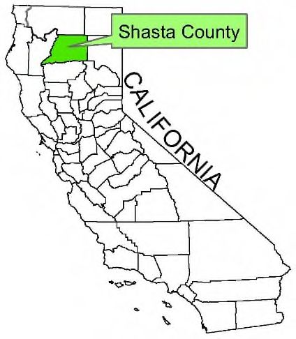
4. Project Location: The project site is an existing quarry located south of the community of Keswick, on the west side of Iron
Mountain Road, approximately 1.0 miles north of the Intersection of Iron Mountain Road and State Route 299 West (SR-
299) and directly across from the intersection of Iron Mountain Road and Laurie Ann Lane (10936 Iron Mountain Road)
(refer to Figure 1, PROJECT LOCATION, and Figure 2, SITE VICINITY).
5. Applicant Name and Address:
Crystal Creek Aggregate, Inc.
Jerry Comingdeer, Owner/Operator
10936 Iron Mountain Road
Redding, CA 96001
6. General Plan Designation: Industrial (I) and Industrial – Interim Mineral Resource Overlay (I-IMR)
7. Zoning: General Industrial (I), Mineral Resources, and Industrial - Interim (I-IMR)
8. Description of Project: Crystal Creek Aggregate (CCA) (herein referred to as “project applicant”) proposes to expand their
existing aggregate mining operation at their current location. CCA was originally permitted in 1990 under Shasta County Use
Permit UP-24-90 and Reclamation Plan 1-90. Subsequently, in 2008 General Plan Amendment 07-005, Zone Amendment
07-020, Use Permit Amendment UP-07-020, and Reclamation Plan Amendment RP-07-022 were approved. A California
Environmental Quality Act (CEQA) Mitigated Negative Declaration, with findings as specifically set forth in Planning
Commission Resolution Nos. 2008-066 and 2008-067 were also adopted approving the various entitlements.
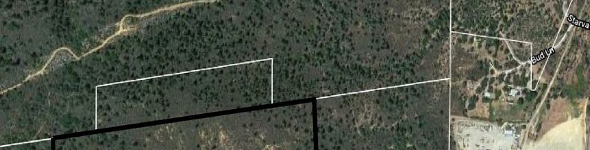
The project applicant proposes an overall project area of approximately 179.97 acres within which the existing approved Use
Permit and Reclamation Plan Areas of 110.69 acres will be maintained but modified to increase the amount of aggregate to
be mined. The use permit area is proposed to be expanded by an additional 69.28 acres referenced as the remaining Mineral
Resource Area (MR) to serve to buffer lands to the south, west and north from noise, light and other mining related activities
(refer to Figure 3, COMPREHENSIVE PROJECT PLAN OVERVIEW).
The total amount of aggregate to be processed yearly is proposed to increase from 250,000 to 500,000 tons and the total
estimated amount proposed to be mined will increase from 15.92 million tons to 25.4 million tons over a period of three
phases with an estimated life of the phases varying from 14 to 35 years. The estimated life of the mining operation will
increase from the currently approved end of Year 2072 by 27 years to end of Year 2099. Also proposed is a portable propane
powered drum mix asphalt plant. The plant could utilize up to 200,000 tons of the 500,000 tons of aggregate processed
yearly for the production of asphalt.
No additional structures or operations other than those associated with the asphalt asphalt plant are proposed. The locations
of the existing scales and office, rock crushing, screen and washing operational, primary and secondary entrances/exits, diesel
fuel storage tanks, waste oil tank, two motor oil and one lubricating oil tank, and five settling and two recycle ponds will
remain. The existing Concrete Recycle Area location and operation for which an administrative permit was issued and
subsequently reissued by the County due to the Carr Fire is proposed as a project component. The location of the material
and topsoil stockpiles will also remain in their current general location which will expand and contract as part of the mining
operation. The number of full-time employees will increase from eight to 14 with one part-time employee. All existing and
proposed uses are allowed under the existing General Plan Land Use Classifications and Zoning District Designations.
CCA UP-19-0007 & RA-19-0001 1 Initial Study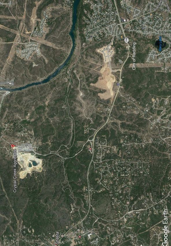
December 2, 2020   California & Shasta County Locations by rkBaron Geovisuals

                             FIGURE 1, PROJECT LOCATION
December 2, 2020

                   FIGURE 2 – SITE VICINITY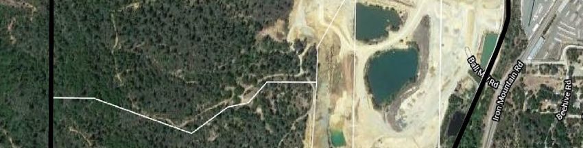
e-...,,_,.....,,,uc.,-11o,.,_,1•..i1
c:]Prole
Amending Use Permit UP-07-020 will modify the design of the existing mining area or quarry of approximately 57.31 acres
         and the plant area of approximately 53.38 acres which together total 110.69 acres that will be maintained as the Reclamation
         Plan Area with associated boundaries. However, the amount of aggregate mined, as noted, will be increased as will the hours
         of operation, particularly with respect to the asphalt plant (24 hours per day generally Sunday evenings through Friday
         afternoons), and yearly blasting maximums (24 instead of 12). The average height of the highwalls will increase from 22 feet
         to 40 feet, except for one highwall at 44 feet. Benches will also be increased in width from 30 feet to 40 feet, except for the
         bench along the perimeter of the pond which will be increased to 60 feet in width. The pond surface area will increase from
         23.49 acres to 32.67 acres.

 9.      Surrounding Land Uses and Setting: The existing quarry is located in an industrial area south of the community of
         Keswick. Surrounding land uses consist of industrial to the east, industrial to the north and low-density residential to the
         northeast and southeast, and undeveloped land to the south and west.

         The topography of the existing quarry floor has been made relatively flat by the removal of the aggregate material over the
         years. The existing bowl shaped quarry face extends upslope and to the west from the quarry floor with horizontal benches
         having been or to be established as excavation proceeds to the extent of the existing quarry boundary. There is an
         approximate 200-foot change in elevation from the existing quarry floor to what would be the top of the quarry face based on
         the current mining plan.

         The project site is located within the boundary of the 2018 Carr Fire. Prior to the area being impacted by the Carr Fire, the
         primary vegetation type present in unmined portions of the project site and vicinity was predominantly knob cone pine and
         chaparral with scattered oaks and ponderosa pine. In areas where the fire burned with lesser intensity, the composition of
         species remains as it existed prior to the fire. Currently, in unmined portions of the project site and vicinity where the fire
         burned with greater intensity, vegetation consists mostly of secondary successional vegetation.

10.      Other public agencies whose approval is required (e.g., permits, financing approval, or participation agreement.):

         California Department of Fish and Wildlife (CDFW)
         California Department of Forestry and Fire Protection (CAL FIRE)
         California Department of Resources and Recycling and Recovery (CalRecycle)
         California Department of Transportation (Caltrans)
         California Department of Toxic Substances Control (DTSC)
         California Division of Mine Reclamation (DMR)
         California Division of Occupational Safety and Health (Cal OSHA)
         California Regional Water Quality Control Board (RWQCB)
         Shasta County Department of Public Works (DPW)
         Shasta County Resource Management Agencies (Air Quality, Environmental Health, Building, Fire)
         Shasta County Sheriff’s Department (Sheriff)

11.      Have California Native American tribes traditionally and culturally affiliated with the project area requested
         consultation pursuant to Public Resources Code section 21080.3.1? If so, is there a plan for consultation that includes,
         for example, the determination of significance of impacts to tribal cultural resources, procedures regarding
         confidentiality, etc.?

         The County’s AB 52 contact list consists of Native American tribes that had submitted written requests for notification of
         CEQA projects within their geographic area of traditional and cultural affiliation as of October 7, 2019, when the County
         initiated consultation. The County sent a letter by certified mail on October 7, 2019 to the Wintu Tribe of Northern California
         and Toyon-Wintu Center. Return receipts for the certified letters indicate the letters were delivered on October 7, 2019. The
         County received no response to the letter.

         NOTE: Conducting consultation early in the CEQA process allows tribal governments, lead agencies, and project
         proponents to discuss the level of environmental review, identify and address potential adverse impacts to tribal
         cultural resources, and reduce the potential for delay and conflict in the environmental review process. (See Public
         Resources Code section 21080.3.2.) Information may also be available from the California Native American Heritage
         Commission’s Sacred Lands File per Public Resources Code section 5097.96 and the California Historical Resources
         Information System administered by the California Office of Historic Preservation. Please also note that Public
         Resources Code section 21082.3(c) contains provisions specific to confidentiality.

 CCA UP-19-0007 & RA-19-0001                                            2                                                    Initial Study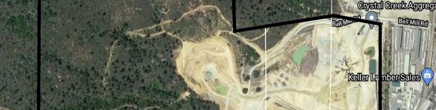
EVALUATION OF ENVIRONMENTAL IMPACTS:

A brief explanation is required for all answers except “No Impact” answers that are adequately supported by the information sources a
lead agency cites in the parenthesis following each question. A “No Impact” answer is adequately supported if all the referenced
information sources show that the impact simply does not apply to projects like the one involved (e.g., the project falls outside a fault
rupture zone). A “No Impact” answer should be explained where it is based on project-specific factors as well as general standards
(e.g., the project will not expose sensitive receptors to pollutants, based on a project-specific screening analysis).

All answers must take account of the whole action involved, including off-site as well as on-site, cumulative as well as project-level,
indirect as well as direct, and construction as well as operational impacts.

Once the lead agency has determined that a particular physical impact may occur, then the checklist answers must indicate whether the
impact is potentially significant, less-than-significant with mitigation, or less-than-significant. “Potentially Significant Impact” is
appropriate if there is substantial evidence that an effect may be significant. If there are one or more, “Potentially Significant Impact”
entries when the determination is made, an EIR is required.

“Negative Declaration: Less-than-significant With Mitigation Incorporated” applies where the incorporation of mitigation measures
has reduced an effect from “Potentially Significant Impact” to a “Less-than-significant Impact.” The lead agency must describe the
mitigation measures, and briefly explain how they reduce the effect to a less-than-significant level (mitigation measures from Section
XVIII, “Earlier Analyses,” may be cross-referenced).

Earlier analyses may be used where, pursuant to the tiering, program EIR, or other CEQA process, an effect has been adequately
analyzed in an earlier EIR or Negative Declaration. Section 15063(c)(3)(D). In this case, a brief discussion should identify the
following:

     a) Earlier Analysis Used. Identify and state where they are available for review.
     b) Impacts Adequately Addressed. Identify which effects from the above checklist were within the scope of and adequately
        analyzed in an earlier document pursuant to applicable legal standards, and state whether such effects were addressed by
        mitigation measures based on the earlier analysis.
     c) Mitigation Measures: For effects that are “Less-than-significant with Mitigation Measures Incorporated,” describe the
        mitigation measures which were incorporated or refined from the earlier document and the extent to which they address site-
        specific conditions for the project.

6)   Lead agencies are encouraged to incorporate into the checklist references to information sources for potential impacts (e.g.
     General Plans, zoning ordinances). Reference to a previously prepared or outside document should, where appropriate, include a
     reference to the page or pages where the statement is substantiated.

7)   Supporting Information Sources: A source list should be attached, and other sources used or individuals contacted should be
     cited in the discussion.

8)   This is only a suggested form, and lead agencies are free to use different formats; however, lead agencies should normally
     address the questions from this checklist that are relevant to a project’s environmental effects in whatever format is selected.

9)   The explanation of each issue should identify the following:

     a) The significance criteria or threshold, if any, used to evaluate each question; and
     b) The mitigation measure identified, if any, to reduce the impact to less-than-significant.

CCA UP-19-0007 & RA-19-0001                                     4                                                            Initial Study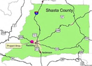
Potentially      Less-Than-      Less-Than-
 I. AESTHETICS: Except as provided in Public Resources Code Section                            Significant With                      No
                                                                                 Significant                      Significant
 21099, would the project:                                                                        Mitigation                       Impact
                                                                                   Impact                           Impact
                                                                                                 Incorporated

 a)     Have a substantial adverse effect on a scenic vista?                                                          X

 b)     Substantially damage scenic resources, including, but not limited to,
        trees, rock outcroppings, and historic buildings within a State scenic                                        X
        highway?

 c)     In non-urbanized areas, substantially degrade the existing visual
        character or quality of public views of the site and its surroundings?
        (Public views are those that are experienced from a publicly
                                                                                                                      X
        accessible vantage point). If the project is in an urbanized area,
        would the project conflict with applicable zoning and other
        regulations governing scenic quality?

 d)     Create a new source of substantial light or glare which would
                                                                                     X
        adversely affect day or nighttime views in the area?

Discussion: Based on the related documents listed in the Sources of Documentation for Initial Study Checklist, staff review of the
project, observations on the project site and in the vicinity, the following determinations can be made:

a)    Scenic vistas are defined as expansive views of highly-valued landscapes from publicly accessible viewpoints. Scenic vistas
      include views of natural features such as topography, water courses, outcrops, and natural vegetation, as well as man-made scenic
      structures. The proposed project is visible from sections of Iron Mountain Road, from residences and residential properties
      located in the community of Keswick, and from residential areas located to the south of State Route 299 (SR-299).
      Implementation of the proposed project would increase the approved height of the quarry highwalls and bench widths from 25
      feet high and 25 feet wide to 40 feet high and wide, respectively. However, this increase would not exceed the approved vertical
      and horizontal limits allowed in the current use permit and reclamation plan. The bench tops would be planted with native trees
      and grasses as part of the proposed reclamation plan. Reclamation would occur in phases, but for periods of time and/or until
      reclamation vegetation is established some rock faces would be exposed. Impacts are considered less-than-significant in this
      regard.

b) The County has not designated specific scenic vistas in the immediate project area as a part of the Shasta County General Plan
   and there is no designated State or federal scenic highways or scenic highway corridors in the vicinity of the proposed project.
   Therefore, the proposed project would not substantially damage any scenic resource. The project site is also not visible from a
   designated scenic highway. Impacts are considered less-than-significant in this regard.

c)    Land immediately adjoining the proposed project to the north, west, and some lands further south and east are under the
      jurisdiction of the Bureau of Land Management (BLM) and in the vicinity of several of Shasta County’s most popular mountain
      biking trails. These facilities are located generally to the north, south, and west of the project site and lands owned by the
      Comingdeer Trust on the adjacent BLM parcels and are associated with the Rock Creek – Middle Creek Trail System and other
      regional trail facilities that connect to the Sacramento River Rail – Trial System. Trailhead parking is provided at various
      locations along Iron Mountain Road between SR-299 and Keswick Dam Road. Iron Mountain Road is also popular with on-road
      bicyclists and many off-road bicyclists use the segment of Iron Mountain Road adjacent to the proposed project to connect to
      French Fry and Trail 58/Middle Creek.

      The project would not degrade the existing visual character or quality of the site and its surroundings as no expansion of the
      existing quarry footprint is proposed. In addition, no additional structures or operations other than those associated with the
      asphalt plant are proposed. The proposed reclamation plan boundary does not extend the current permitted mine boundary. The
      locations of the existing scales and office, rock crushing, screen and washing operations, primary and secondary entrances/exits,
      diesel fuel storage tanks, waste oil tank, two motor oil and one lubricating oil tank, and five settling and two recycle ponds will
      remain. Impacts are considered less-than-significant in this regard.

d) Light pollution occurs when nighttime views of the stars and sky are diminished by an over-abundance of light coming from the
   ground. Light pollution is a potential impact from the operation of any light source at night. Proper light shields, lighting design,
   and landscaping are commonly used to reduce light pollution generated from lighting by blocking the conveyance of light
   upwards. The result is that the lights are not visible from above; therefore, ambient light is not added to the nighttime sky. In
   addition, light reflecting off surfaces during daylight hours has the potential to create a source of glare in the vicinity of the
   proposed project.

CCA UP-19-0007 & RA-19-0001                                            5                                                        Initial Study
Implementation of the proposed project which includes periodic nighttime asphalt plant operations would potentially create a new
source of substantial light or glare which could result in night sky illumination and/or other adverse effects on nighttime views in
and around the area. Further investigation and analysis will need to be conducted to assess the visibility of the proposed project
and to assess the potential lighting impacts. Therefore, this potential impact will be fully analyzed in the EIR.
Findings: In the course of the above evaluation, impacts associated with Aesthetics were found to be potentially significant.
Additional project and environmental data, further discussion and analysis of environmental impacts, recommendations for mitigations
for potential impacts, and a mitigation monitoring plan, will be included in the EIR prepared for this proposed project.
II. AGRICULTURE AND FORESTRY RESOURCES: In determining
whether impacts to agricultural resources are significant environmental effects, lead
agencies may refer to the California Agricultural Land Evaluation and Site Assessment
Model (1997) prepared by the California Dept. of Conservation as an optional model to
use in assessing impacts on agriculture and farmland. In determining whether impacts
Less-Than-
Potentially Less-Than-
to forest resources, including timberland, are significant environmental effects, lead Significant With No
Significant Significant
agencies may refer to information compiled by the California Department of Forestry Mitigation Impact
Impact Impact
and Fire Protection regarding the state’s inventory of forest land, including the Forest Incorporated
and Range Assessment Project and the Forest Legacy Assessment project; and forest
carbon measurement methodology provided in Forest Protocols adopted by the
California Air Resources Board. Would the project:
a) Convert Prime Farmland, Unique Farmland, or Statewide Importance
(Farmland), as shown on the maps prepared pursuant to the Farmland X
Mapping and Monitoring Program of the California Resources Agency,
to non-agricultural use?
b) Conflict with existing zoning for agricultural use, or a Williamson Act X
Contract?
c) Conflict with existing zoning for, or cause rezoning of, forest land (as
defined in Public Resources Code section 12220(g)), timberland (as
defined by Public Resources Code section 4526), or timberland zoned X
Timberland Production (as defined by Government Code section
51104(g))?
d) Result in the loss of forest land or conversion of forest land to non-forest X
use?
e) Involve other changes in the existing environment which, due to their
X
location or nature, could result in conversion of Farmland, to non-
agricultural use or conversion of forest land to non-forest use?
Discussion: Based on the related documents listed in the Sources of Documentation for Initial Study Checklist, staff review of the
project, observations on the project site and in the vicinity, the following determination can be made:
a) The soils found on the project area belong to the Diamond Springs series. This series consists of well drained soils that are
underlain by granitic or light-colored metavolcanic rocks. These soils are on uplands near Shasta, Keswick and Ingot. Slopes
range from 8 to 50 percent with annual precipitation of between 40 and 50 inches.
The project site has not been historically used for agricultural purposes, nor does it possess soils that are prime for agricultural
production. The site is not located within an area of Prime Farmland as identified by the California Department of Conservation’s
Important Farmland Series Mapping and Monitoring Program. The subject property is not identified as Prime Farmland, Unique
Farmland, or Statewide Importance on the map titled Shasta County Important Farmland 2016. Therefore, the proposed project
would not convert prime farmland, unique farmland, or farmland of statewide importance to nonagricultural use and there would
be no impact which means that this impact will not be evaluated in the EIR.
b) The project area is not currently under a Williamson Act Contract nor is it zoned for agricultural use by Shasta County.
Consequently, the proposed project would not conflict with existing zoning for agricultural use or a Williamson Act Contract.
Therefore, there would be no impact from the proposed project and the impact will not be evaluated in the EIR.
CCA UP-19-0007 & RA-19-0001 6 Initial Studyc) The project would not conflict with existing zoning for, or cause rezoning of, forest land (as defined in Public Resources Code
section 12220(g)), timberland (as defined by Public Resources Code section 4526), or timberland zoned Timberland Production
(as defined by Government Code section 51104(g)). The project site is not forest land, timberland or zone Timberland Production.
Therefore, the proposed project would not conflict with existing zoning or cause rezoning and would have no impact on
timberlands zoned as Timber Production. As such, this impact will not be analyzed further in the EIR.
d) The project would not result in the loss of forest land or conversion of forest land to non-forest use. The project site is not forest
land. In addition the proposed project is not located in an area of significant agricultural soils. As such, this impact will not be
analyzed further in the EIR.
Findings: In the course of the above evaluation, impacts associated with Agriculture and Forestry Resources were found to not be
significant because of the inability of a project of this scope to create such impacts or the absence of project characteristics producing
effects of this type. The effects determined not to be significant are not required to be included in primary analysis sections of the EIR.
As such, impacts to Agriculture and Forestry Resources are not reasonably foreseeable and will not be addressed further in the EIR to
be prepared for this project.
III. AIR QUALITY: Where available, the significance criteria established by the Less-Than-
Potentially Less-Than-
applicable air quality management district or air pollution control district may be Significant With No
Significant Significant
relied upon to make the following determinations. Would the project: Mitigation Impact
Impact Impact
Incorporated
a) Conflict with or obstruct implementation of the applicable air quality
X
plan?
b) Result in a cumulatively considerable net increase of any criteria
pollutant for which the project region is non-attainment under an X
applicable Federal or State ambient air quality standard?
c) Expose sensitive receptors to substantial pollutant concentrations? X
d) Result in other emissions (such as those leading to odors) adversely
X
affecting a substantial number of people?
Discussion: Based on related documents listed in the Sources of Documentation for Initial Study Checklist, staff review of the project,
observations on the project site and in the vicinity, the following findings can be made:
a) The applicable air quality plan for the project area is the Northern Sacramento Valley Air Basin’s (NSVAB’s) 2018 Air Quality
Attainment Plan (“Plan”). The Plan is primarily concerned with the pollutant ozone for which the NSVAB has been designated
non-attainment. In particular, the Plan presents strategies necessary to attain the California ambient air quality standard for the 1-
hour ozone standard at the earliest practicable date. Due to the scale of the proposed project, further analysis is required to
determine the extent to which increases in nitrogen oxides (NOx), reactive organic gases (ROG), and inhalable particulate matter
(PM10) generated from project construction and operational activities may conflict with or obstruct implementation of the Air
Quality Attainment Plan as well as what, if any, mitigation measures should be incorporated to reduce the impacts to a level that
is less-than-significant. Therefore, these impacts are considered to be potentially significant and will need to be addressed in an
EIR.
b-c) Primary air pollutant emissions associated with operation of the asphalt plant would include natural gas combustion associated
with aggregate drying and asphalt cement heating (carbon monoxide [CO], nitrogen oxides [NO x],sulfur dioxide [SO2],
particulate matter [PM10/PM2.5], reactive organic gases [ROG]), and dryer dust [PM 10/PM2.5]). The project could potentially
result in a cumulatively considerable net increase of criteria pollutants, including ozone, ozone pre-cursors or PM10, the
pollutants for which the Northern Sacramento Valley Air Basin is in non-attainment under the applicable State ambient air
quality standard. Preliminary review merits further evaluation and possible mitigation. Therefore, these potential impacts will be
fully analyzed and evaluated in the EIR.
d) The project could potentially result in air emissions which would create objectionable odors affecting a substantial number of
people. Operational air contaminants include diesel emissions from on- and off-road vehicles and equipment, and diesel and
process emissions, including odors.
CCA UP-19-0007 & RA-19-0001 7 Initial StudyThe type of asphalt plant proposed is a portable drum mix type that will be powered by propane gas, which produces
significantly less nitrogen oxide (NOx) emissions (approximately 76 percent less), sulfur dioxide (SO 2) emissions, and some
hazardous air pollutants than an oil fired plant. This process is a continuous mixing type process whereby the dryer is used, not
only to dry the material, but also to thoroughly mix the heated and dried aggregates with the liquid asphalt cement. After mixing,
the heated asphalt is discharged at the end of the drum and conveyed to Hot Mix Asphalt (HMA) or Warm Mix Asphalt (WMA)
silos where the asphalt is stored and loaded onto trucks for delivery to project sites. The primary odor-causing compound from
asphalt and the aggregate processing facilities, hydrogen sulfide (H2S), has the potential to cause localized odor impacts in the
vicinity of the project site. Preliminary review merits further evaluation and possible mitigation. Therefore, these potential
impacts will be fully analyzed and evaluated in the EIR.
Findings: In the course of the above evaluation, impacts associated with Air Quality were found to be potentially significant.
Additional project and environmental data, further discussion and analysis of environmental impacts, recommendations for mitigations
for potential impacts, and a mitigation monitoring plan, will be included in the EIR prepared for this proposed project.
Less-Than-
Potentially Less-Than-
IV. BIOLOGICAL RESOURCES: Would the project: Significant With No
Significant Significant
Mitigation Impact
Impact Impact
Incorporated
a) Have a substantial effect, either directly or through habitat
modifications, on any species identified as a candidate, sensitive, or
special-status species in local or regional plans, policies, or regulations, X
or by the California Department of Fish and Wildlife or U.S. Fish and
Wildlife Service?
b) Have a substantial adverse effect on any riparian habitat or other
sensitive natural community identified in local of regional plans,
policies, and regulations or by the California Department of Fish and X
Wildlife or U.S. Fish and Wildlife Service?
c) Have a substantial adverse effect on state or Federally protected
wetlands (including, but not limited to, marsh, vernal pool, coastal, etc.)
through direct removal, filling, hydrological interruption, or other X
means?
d) Interfere substantially with the movement of any native resident or
migratory fish or wildlife species or with established native resident or
migratory wildlife corridors, or impede the use of native wildlife X
nursery sites?
e) Conflict with any local policies or ordinances protecting biological X
resources, such as a tree preservation policy or ordinance?
f) Conflict with the provisions of an adopted Habitat Conservation Plan,
Natural Community, Conservation Plan, or other approved local, X
regional, or State habitat conservation plan?
Discussion: Based on the related documents listed in the Sources of Documentation for Initial Study Checklist, staff review of the
project, observations on the project site and in the vicinity, the following determinations can be made:
a-d) On October 29, 2019, the California Department of Fish and Wildlife (CDFW) provided a response to Shasta County’s 2019
Notice of Preparation (NOP) for the previously considered onsite expansion of the quarry (GPA 19-0003, ZA 19-0002, UP 19-
0007, RP 19-0001) (State Clearinghouse No. 2019090702). Comments and recommendations in the letter refer to the
forthcoming EIR and the studies and data that will inform analysis of baseline conditions and potential impacts. Specific
reference was made to special-status species and habitat surveys. Additional comments and recommendations, in general,
referred to: additional special-status species and habitat surveys; evaluation of potential impacts to California Endangered
Species Act (CESA) listed species (or plants or animals listed as endangered or threatened under CESA); rare plant and sensitive
natural communities; and additional monitoring and studies related to wildlife and aquatic resources, among other issues.
A biological resources assessment will be prepared to address potential impacts to sensitive biological resources based on the
applicable recommendations of CDFW’s October 29, 2019 letter and any further information provided by CDFW during this
NOP process. The biological resources assessment and any further studies necessary to determine the project’s potential impacts
on biological resources will be fully analyzed in the EIR.
CCA UP-19-0007 & RA-19-0001 8 Initial Studye) The proposed project would not conflict with any ordinances or policies which protect biological resources. Shasta County Board
of Supervisors’ Resolution No. 95-157 provides guidance regarding use and protection of oak trees on a voluntary basis.
Implementation of the proposed project would not result in the removal of trees outside the currently permitted quarry area. No
impacts would occur in this regard.
f) There are currently no adopted Habitat Conservation Plans, Natural Community Conservation Plans, or other approved local,
regional, or State habitat conservation plans for the project site or project area. There would not be any conflict with local
policies or ordinances protecting biological resources, nor with any habitat conservation plans. No impacts would occur in this
regard.
Findings: In the course of the above evaluation, impacts associated with Biological Resources were found to be potentially
significant. Additional project and environmental data, further discussion and analysis of environmental impacts, recommendations
for mitigations for potential impacts, and a mitigation monitoring plan, will be included in the EIR prepared for this proposed project.
Less-Than-
Potentially Less-Than-
V. CULTURAL RESOURCES: Would the project: Significant With No
Significant Significant
Mitigation Impact
Impact Impact
Incorporated
a) Cause a substantial adverse change in the significance of a historical
resource pursuant to §15064.5? X
b) Cause a substantial adverse change in the significance of an X
archaeological resource pursuant to §15064.5?
c) Disturb any human remains, including those interred outside of formal X
cemeteries?
Discussion: Based on the related documents listed in the Sources of Documentation for Initial Study Checklist, staff review of the
project, observations on the project site and in the vicinity, the following determinations can be made:
a-b) Based on the result of the Archaeological Inventory Survey (Land Designers, 2006) prepared for the previous 2008 General Plan
Amendment 07-005, Zone Amendment 07-020, Use Permit Amendment, UP-07-020, and Reclamation Plan Amendment RP-07-
022, no previously unidentified sites or features dating to historic time periods were observed during the survey. These negative
results are explained primarily by the extensive disturbance to which all of the project area has been subjected. Two previously
identified historic sites had been recorded within the project area. Both of these sites were evaluated for significance per CEQA
and eligibility per the National Register of Historic Places, with Jensen concluding (2002), and the United States Bureau of Land
Management (BLM) and California State Historic Preservation Office (SHPO) concurring, that neither one is eligible for
inclusion on the National Register or significant per CEQA, due to lack of integrity dating to the period of potential significance
of these sites. As a consequence of this recommendation and concurrence by BLM and California SHPO, no treatment or
mitigative action was recommended.
The same conclusion is relevant for the twelve previously identified Isolates in the 2006 Archaeological Inventory Survey.
Isolates are themselves categorically excluded as significant or potentially significant per CEQA or eligible for inclusion on the
National Register of Historic Places. Again, no treatment or mitigative action was recommended in relation to potential impacts
to these twelve Isolates might accompany the 2002 proposed land exchange, or any future development or impacts to which the
property might be subject, such as the present licensing and reclamation plan.
The proposed project would result in a significant impact if it caused a substantial adverse change in the significance of an
archaeological resource. Based on the results of the investigations described above, there are no resources in the Project Area
with intact visible surface manifestations that qualify as archaeological resources or historical resources as defined by CEQA
Guidelines Section 15064.5. However, there is the possibility of encountering buried archaeological resources during project
activities, including ground disturbing activities onsite and at off-site intersection improvements. Additional evaluation in the
EIR is required.
c) There are no known burial sites on the proposed project site. If human remains are unearthed during future development of the
site, the provisions of California Health and Safety Code Section 7050.5 shall apply. Under this Section, no further disturbance
shall occur until the County Coroner has made the necessary findings as to origin and disposition, pursuant to California Public
Resources Code Section 5097.98.
CCA UP-19-0007 & RA-19-0001 9 Initial StudyFindings: In the course of the above evaluation, impacts associated with Cultural Resources were found to be potentially significant.
Additional project and environmental data, further discussion and analysis of environmental impacts, recommendations for mitigations
for potential impacts, and a mitigation monitoring plan, will be included in the EIR prepared for this proposed project.
Potentially Less-Than- Less-Than-
Significant With No
VI. ENERGY: Would the project: Significant Significant
Mitigation Impact
Impact Impact
Incorporated
a) Result in potentially significant environmental impact due to
wasteful, inefficient, or unnecessary consumption of energy resources X
during project construction or operation?
b) Conflict with or obstruct a state or local plan for renewable energy or
energy efficiency? X
Discussion: Based on the related documents listed in the Sources of Documentation for Initial Study Checklist, staff review of the
project, observations on the project site and in the vicinity, the following determinations can be made:
a) No new buildings or structures requiring electric power service or additional energy consumption are proposed with the exception
of lighting for the asphalt plant. Further evaluation of potential impacts to energy resources related to the increased hours of
operation, including the proposed asphalt plant will be addressed in the EIR.
b) The project would not conflict with or obstruct a state or local plan for renewable energy or energy efficiency. The project has no
effect on the County’s efforts to develop renewable energy sources for County facilities when practical. Less-than-significant
impacts would occur in this regard.
Findings: In the course of the above evaluation, impacts associated with Energy were found to be potentially significant. Additional
project and environmental data, further discussion and analysis of environmental impacts, recommendations for mitigations for
potential impacts, and a mitigation monitoring plan, will be included in the EIR prepared for this proposed project.
Potentially Less-Than- Less-Than-
Significant With No
VII. GEOLOGY AND SOILS: Would the project: Significant Significant
Mitigation Impact
Impact Impact
Incorporated
a) Directly or indirectly cause potential substantial adverse effects,
including the risk of loss, injury, or death involving:
i) Rupture of a known earthquake, fault, as delineated on the
most recent Alquist-Priolo Earthquake Fault Zoning Map
issued by the State Geologist for the area or based on other X
substantial evidence of a known fault? Refer to Division of
Mines and Geology Special Publications 42.
ii) Strong seismic ground shaking?
iii) Seismic-related ground failure, including liquefaction?
iv) Landslides?
b) Result in substantial soil erosion or the loss of topsoil? X
c) Be located on a geologic unit or soil that is unstable, or that would
become unstable as a result of the project, and potentially result in on-
X
or off-site landslide, lateral spreading, subsidence, liquefaction, or
collapse?
d) Be located on expansive soil, as defined in Table 18-1-B of the
Uniform Building Code (1994), creating substantial direct or indirect X
risks to life or property?
e) Have soils incapable of adequately supporting the use of septic tanks
or alternative wastewater disposal systems where sewers are not X
available for the disposal of waste water?
CCA UP-19-0007 & RA-19-0001 10 Initial StudyPotentially Less-Than- Less-Than-
Significant With No
VII. GEOLOGY AND SOILS: Would the project: Significant Significant
Mitigation Impact
Impact Impact
Incorporated
f) Directly or indirectly destroy a unique paleontological resource or site
X
or unique geologic feature?
Discussion: Based on the related documents listed in the Sources of Documentation for Initial Study Checklist, staff review of the
project, observations on the project site and in the vicinity, the following determinations can be made:
a) The project would not directly or indirectly cause potential substantial adverse effects, including the risk of loss, injury, or death
involving:
i) Rupture of a known earthquake fault
The California Geologic Survey (CGS) evaluates the activity rating of a fault in fault evaluation reports (FERs). FERs compile
available geologic and seismologic data and evaluate if a fault should be zoned as Holocene-active, pre-Holocene, or age
undetermined. If an FER evaluates a fault as Holocene-active, then it is typically incorporated into a Special Studies Zone in
accordance with the Alquist-Priolo Earthquake Fault Zoning Act (AP). AP Special Studies Zones require site-specific evaluation
of fault location for structures for human occupancy and require a habitable structure setback if the fault is found traversing a
project site. The proposed project is not located within an Alquist-Priolo Earthquake Fault Zone established by the State. Because
of this, the likelihood of faulting occurring across the quarry site is low.
A number of regional faults are present in the project area. The closest mapped faults to the site are the pre-Holocene Hoadley and
Spring Creek faults, both located within a few miles of the site. The closest mapped Holocene-active fault is the Hat Creek-
McArthur fault zone, located about 39 miles east of the site. Based on this existing information, there will be less-than-significant
impacts related to surface fault rupture.
ii) Strong seismic ground shaking
Although there are no known earthquake faults in the project vicinity, the entire northern California region is subject to the
potential for moderate to strong seismic shaking due to distant seismic sources. Seismic shaking can be generated on faults many
miles from the project vicinity. Renewed activity at Mt. Shasta or Mt. Lassen, would presumably be associated with seismicity
and potential strong ground shaking. Seismic shaking potential is, therefore, a regional hazard; the hazard is not higher or lower at
the project site than throughout the region. Standard design and construction practices meeting current California Building Codes
(where applicable) will provide adequate protection for the proposed project. The implementation of these standard building
practices will result in less-than-significant impacts related seismic ground shaking in the area.
iii) Seismic-related ground failure, including liquefaction
Seismic ground settlement is not considered a hazard at the site due to the fact that the site is underlain by solid granitic rock and
is not submit to seismic ground failure. No impacts are anticipated in this regard.
iv) Landslides.
Landslides occur throughout Shasta County, although they have not been considered a major problem. Landslides are more
prevalent in the eastern and northern portions of the county and are commonly related to the sedimentary and volcanic rocks in
these vicinities. Based on the project’s Geotechnical Report, the change in horizontal and vertical bench proposed has been
evaluated and indicate that the proposed walls and benches as designed would remain stable. Less-than-significant impacts would
occur in this regard.
b) The soils found on the project area belong to the Diamond Springs series. This series consists of well drained soils that are
underlain by granitic or light-colored metavolcanic rocks. These soils are on uplands near Shasta, Keswick and Ingot. Slopes
range from 8 to 50 percent with annual precipitation of between 40 and 50 inches.
As discussed in greater detail below under Item X.a, the proposed project will continue to comply with the statewide Construction
General Permit (Order No. 2009-0009-DWQ) and the Industrial Storm Water General Permit (Order No. 2014-0057-DWQ). The
proposed project would be subject to the requirements of Shasta County Code Chapter 12.12 related to grading. Compliance with
the statewide Construction General Permit and Shasta County Code Chapter 12.12 of would serve to ensure that short-term
surface water quality impacts are minimized. Impacts would be less-than-significant in this regard.
CCA UP-19-0007 & RA-19-0001 11 Initial Studyc) The threat of landslides, lateral spreading, subsidence, liquefaction, or collapse is insignificant as the geology of the area
demonstrates stability. As noted above, based on the project Geotechnical Report, the change in horizontal and vertical bench
proposed has been evaluated and indicate that the proposed walls and benches as designed would remain stable. Less-than-
significant impacts would occur in this regard.
d) Shasta County is characterized by moderate to low expansiveness in soils with small scattered areas of high expansiveness. The
proposed project is not located on expansive soils. No impact would occur in this regard.
e) The proposed project does not propose any wastewater facilities or the development of any additional onsite septic systems,
therefore will be no impact.
f) The proposed project would not directly or indirectly destroy a unique paleontological resource or site or unique geologic feature.
Findings: In the course of the above evaluation, impacts associated with Geology and Soils were found to not be significant because
of the inability of a project of this scope to create such impacts or the absence of project characteristics producing effects of this type.
The effects determined not to be significant are not required to be included in primary analysis sections of the EIR. As such, impacts
to Geology and Soils are not reasonably foreseeable and will not be addressed further in the EIR to be prepared for this project.
Potentially Less-Than- Less-Than-
Significant With No
VIII. GREENHOUSE GAS EMISSIONS: Would the project: Significant Significant
Mitigation Impact
Impact Impact
Incorporated
a) Generate greenhouse gas emissions, either directly or indirectly, that
X
may have a significant impact on the environment?
b) Conflict with an applicable plan, policy or regulation adopted for the
X
purpose of reducing the emissions of greenhouse gases?
Discussion: Based on these comments, the related documents listed in the Sources of Documentation for Initial Study Checklist, staff
review of the project, observations on the project site and in the vicinity, the following determinations can be made:
a) Impacts associated with greenhouse gas emissions are more appropriately evaluated on a regional level than at a project scale as
greenhouse gas impacts on the atmosphere are generally independent of the point of emission. The internal combustion of fuels to
power heavy equipment for construction as well as vehicles trips associated with the proposed project construction and operation
will generate greenhouse gases. However, construction and operation‐related emissions would occur at a low enough level that
they are expected to have a negligible effect to climate change.
Proposed project emissions will need to be modeled to determine if the proposed project would generate greenhouse gas
emissions, either directly or indirectly that might have a significant impact on the environment. This is considered a potentially
significant impact and will be further addressed in the EIR.
b) The project could conflict with an applicable plan, policy or regulation adopted for the purpose of reducing the emissions of
greenhouse gases. Shasta County has drafted a Regional Climate Action Plan; however, this plan has not been adopted. Further
evaluation in the EIR is required.
Findings: In the course of the above evaluation, impacts associated with Greenhouse Gas Emissions were found to be potentially
significant. Additional project and environmental data, further discussion and analysis of environmental impacts, recommendations
for mitigations for potential impacts, and a mitigation monitoring plan, will be included in the EIR prepared for this proposed project.
Potentially Less-Than- Less-Than-
Significant With No
IX. HAZARDS AND HAZARDOUS MATERIALS: Would the project: Significant Significant
Mitigation Impact
Impact Impact
Incorporated
a) Create a significant hazard to the public or the environment through the
X
routine transport, use, or disposal of hazardous materials?
b) Create a significant hazard to the public or the environment through
reasonably foreseeable upset and accident conditions involving the X
release of hazardous materials into the environment?
c) Emit hazardous emissions or handle hazardous or acutely hazardous
materials, substances, or waste within one-quarter mile of an existing or X
proposed school?
CCA UP-19-0007 & RA-19-0001 12 Initial StudyPotentially Less-Than- Less-Than-
Significant With No
IX. HAZARDS AND HAZARDOUS MATERIALS: Would the project: Significant Significant
Mitigation Impact
Impact Impact
Incorporated
d) Be located on a site which is included on a list of hazardous materials
sites compiled pursuant to Government Code Section 65962.5 and, as a
X
result, would it create a significant hazard to the public or the
environment?
e) For a project located within an airport land use plan or, where such a
plan has not been adopted, within two miles of a public airport or public
X
use airport, would the project result in a safety hazard or excessive noise
for people residing or working in the project area?
f) Impair implementation of or physically interfere with an adopted
X
emergency response plan or emergency evacuation plan?
g) Expose people or structures, either directly or indirectly, to a significant
X
risk of loss, injury, or death involving wildland fires?
Discussion: Based on these comments, the related documents listed in the Sources of Documentation for Initial Study Checklist, staff
review of the project, observations on the project site and in the vicinity, the following determinations can be made:
a) Hazards are those physical safety factors that can cause injury or death, and while by themselves in isolation may not pose a
significant safety hazard to the public, when combined with development of projects can exacerbate hazardous conditions.
Hazardous materials are typically chemicals or processes that are used or generated by a project that could pose harm to people,
working at the site or on adjacent areas. Many of these chemicals can cause hazardous conditions to occur should they be
improperly disposed of or accidentally spilled as part of project development or operations. Hazardous materials are also those
listed as hazardous pursuant to Government Code Section 65962.5.
The Shasta County Environmental Health Division (EHD) is the administering agency and the Certified Unified Program Agency
(CUPA) for Shasta County with responsibility for regulating hazardous materials handlers, hazardous waste generators,
underground storage tank facilities, above ground storage tanks, and stationary sources handling regulated substances. A
Hazardous Materials Business Plan (HMBP) is required of businesses in Shasta County that handle, use, generate, or store
hazardous materials. The primary purpose of this plan is to provide readily available information regarding the location, type and
health risks of hazardous materials to emergency response personnel, authorized government officials, and the public. Large cases
of hazardous materials contamination or violations are referred to the Central Valley Regional Water Quality Control Board
(RWQCB) and the California Department of Toxic Substances Control (DTSC).
The proposed project would not create a significant hazard to the public or the environment through the routine transport, use, or
disposal of hazardous materials. The existing quarry and aggregate processing operation uses small amounts of fuel and lubricants
and is subject to the County’s HMBP program, which is regulated by the Shasta County EHD as part of the Certified Unified
Program (CUPA). The program requires the preparation of a document that provides an inventory of hazardous materials onsite,
emergency plans and procedures in the event of an accidental release, and training for employees on safety procedures for
handling hazardous materials and in the event of a release or threatened release. These plans are routine documents that are
intended to disclose the presence of hazardous materials and provide information on what to do if materials are inadvertently
released.
There is a business plan on file with the Shasta County EHD which conducts periodic site inspections. Blasting of quarry rock has
historically occurred onsite and the frequency of blasting will slightly increase with implementation of the proposed project.
Explosive and detonators are not stored onsite and are only onsite when a blast is being set up. Less-than-significant impacts are
anticipated in this regard.
b) The level of risk associated with the accidental release of hazardous substances is not considered significant due to the small
volume and low concentration of hazardous materials used during onsite currently and the generally low level of hazardous
materials utilized for asphalt plant operations. Onsite operations would be required to continue to use standard operational
controls and safety procedures that would avoid and minimize the potential for accidental release of such substances into the
environment. Standard practices would be observed such that any materials released are appropriately contained and remediated
as required by local, State, and federal law. Implementation of the proposed project would result in less-than-significant impacts
in this regard.
CCA UP-19-0007 & RA-19-0001 13 Initial Studyc) The project would not emit hazardous emissions or handle hazardous or acutely hazardous materials, substances, or waste within
one-quarter mile of an existing or proposed school. The proposed project is not located within one-quarter mile of an existing or
proposed school. No impacts would occur in this regard.
d) The project is not located on a site which is included on a list of hazardous materials sites and would not create a significant
hazard to the public or the environment. The project site is not included on the list of hazardous materials sites compiled by the
California Department of Toxic Substances Control. No impacts would occur in this regard.
e) The project is not located within an airport land use plan or within two miles of a public airport or public use airport. The nearest
airport to the project site is the Benton Airport located approximately 3.5 miles to the southeast. No impacts would occur in this
regard.
f) The project would not impair implementation of or physically interfere with an adopted emergency response plan or emergency
evacuation plan. Currently, the County has not adopted comprehensive emergency evacuation plan applicable to this area. In
addition, neither Iron Mountain Road nor Keswick Dam Road is identified as a designated evacuation route by the County.
However, Iron Mountain Road provides the primary access from State Route 299 (SR-299) for residents and emergency crews to
the area, including the community of Keswick. Keswick Dam Road intersects with Iron Mountain Road approximately 0.5 miles
north of the site and provides important emergency ingress and egress (WSRCD 2016). The potential for the proposed project to
impact emergency response will be evaluated in the EIR.
g) The outbreak and spread of wildland fires within the project area is a potential danger, particularly during the hot, dry summer
and fall months. Various factors contribute to the intensity and spread of wildland fires: humidity, wind speed and direction,
vegetation type, the amount of vegetation (fuel), and topography. The topography, climate, and vegetation of much of the area are
conducive to the spread of wildland fires once started.
The most significant fire incident to impact the western Shasta County, including the project site and adjacent community, was
the 2018 Carr Fire. The Carr Fire began July 23, 2018 at approximately 1:15 p.m. from a suspected vehicle mechanical failure.
The fire origin was within Whiskeytown National Recreation Area (NRA), and spread to lands administered by the Bureau of
Land Management (BLM) and United States Forest Service (USFS) in subsequent days.
On the morning of Thursday, July 26, 2018 the California Department of Forestry and Fire Protection (CAL FIRE) moved onto
the existing quarry site with approximately four bulldozers, four helicopters, 60 to 100 different fire engines and water tenders.
Onsite ponds (pond No. 4 and No. 5) provided water resources to fire suppression helicopters, water tenders, and fire engines.
However, they left due to the fire tornado that began that night and continued into the following morning. On Sunday, July 29,
2018, Pacific Gas & Electric Company (PG&E) and their contractor, Outback Contractors, Inc. mobilized onsite and utilized the
entire site essentially as a command center. Over 500 pieces of major equipment, including but not limited to; trailers, backhoes,
gravel trucks, four to five helicopters, trucks, and associated personnel, occupied the site.
According the Carr Incident Damage Inspection Report (DINS) prepared by CAL FIRE, 819 residential structures were
destroyed in unincorporated Shasta County (CAL FIRE 2018). This includes most of the residential structures within and
surrounding the community of Keswick. At the time of the fire the community of Keswick had an estimated population of 327
residents (WSRCD 2016). As of November 2019, single-family residential building permit activity within the unincorporated
portions of Shasta County impacted by the Carr Fire include the following: four permits ready to issue, 110 permits issues, 28
permit applications applied and under review, four permits cancelled or voided, and 31 permits finalized (Shasta County 2019).
The California Department of Forestry and Fire Protection (CAL FIRE) has mapped areas of significant fire hazards in the state
through its Fire and Resources Assessment Program (FRAP). These maps place areas of the state into different fire hazard
severity zones (FHSZ) based on a hazard scoring system using subjective criteria for fuels, fire history, terrain influences, housing
density, and occurrence of severe fire weather where urban conflagration could result in catastrophic losses. As part of this
mapping system, land where CAL FIRE is responsible for wildland fire protection and generally located in unincorporated areas
is classified as a State Responsibility Area (SRA). Where local fire protection agencies, such as the Shasta County Fire
Department, are responsible for wildfire protection, the land is classified as a Local Responsibility Area (LRA). CAL FIRE
currently identifies the project site as an SRA. In addition to establishing local or state responsibility for wildfire protection in a
specific area, CAL FIRE designates areas as very high fire hazard severity zones (VHFHSZ) or non-VHFHSZ. The project site is
designated as VHFHSZ by CAL FIRE.
Permitted mine activities occur immediately adjacent to undeveloped lands managed by the Bureau of Land Management (BLM)
and continually encroach into onsite permitted open space to access economically viable mineral deposits. As noted above, the
project site and areas surrounding it have been designated as a VHFHSZ by CAL FIRE and are susceptible to wildfires. Existing
houses and structures east the project area, including new residential structures being built in and around the Keswick community,
CCA UP-19-0007 & RA-19-0001 14 Initial StudyYou can also read