Let's Get Wellington Moving Baseline report: Land use and urban form
←
→
Page content transcription
If your browser does not render page correctly, please read the page content below
WELLINGTON CITY COUNCIL

          Let’s Get Wellington Moving

Baseline report: Land use and urban form

 Lucie Desrosiers, Senior Spatial Planning Advisor, Wellington City Council
                               14/06/2017
Contents
Executive summary ................................................................................................................................. 3
1.      Introduction .................................................................................................................................... 7
     1.1 Background ................................................................................................................................... 7
     1.2 Purpose of the report ................................................................................................................... 7
2.      Future vision for Wellington City .................................................................................................... 7
     2.1 Towards 2040: Smart Capital ........................................................................................................ 7
     2.2 Wellington Urban Growth Plan: Urban Development and Transport Strategy 2014-43.............. 9
     2.3 District Plan – Central Area ......................................................................................................... 10
     2.4 Wellington Waterfront Framework ............................................................................................ 12
     2.5 Central City Framework .............................................................................................................. 12
        2.5.1 Boulevards ........................................................................................................................... 13
        2.5.2 East-west connectors ........................................................................................................... 14
        2.5.3 Laneways .............................................................................................................................. 15
        2.5.4 Open spaces ......................................................................................................................... 15
        2.4.5 Precincts ............................................................................................................................... 15
3. Current land uses in the central city ................................................................................................. 19
     3.1 Residential accommodation ....................................................................................................... 19
     3.2 Residential development trends ................................................................................................. 21
     3.3 Office accommodation ............................................................................................................... 23
     3.4 Retail accommodation ................................................................................................................ 28
4. Forecast growth ................................................................................................................................ 30
     4.1 Wellington Region ....................................................................................................................... 30
     4.2 Wellington City............................................................................................................................ 31
5. Future land uses ................................................................................................................................ 33
     5.1 Wellington Region ....................................................................................................................... 33
     5.2 Wellington City............................................................................................................................ 33
        5.2.1 Central city ........................................................................................................................... 34
        5.2.2 Intensification of existing suburban areas ........................................................................... 37
        5.2.3 Greenfield expansion ........................................................................................................... 41
        5.2.4 Low growth areas ................................................................................................................. 41
6. Liveability .......................................................................................................................................... 42
     6.1 Walkability .................................................................................................................................. 43
     6.2 Amenity ....................................................................................................................................... 45

                                                                                                                                                          1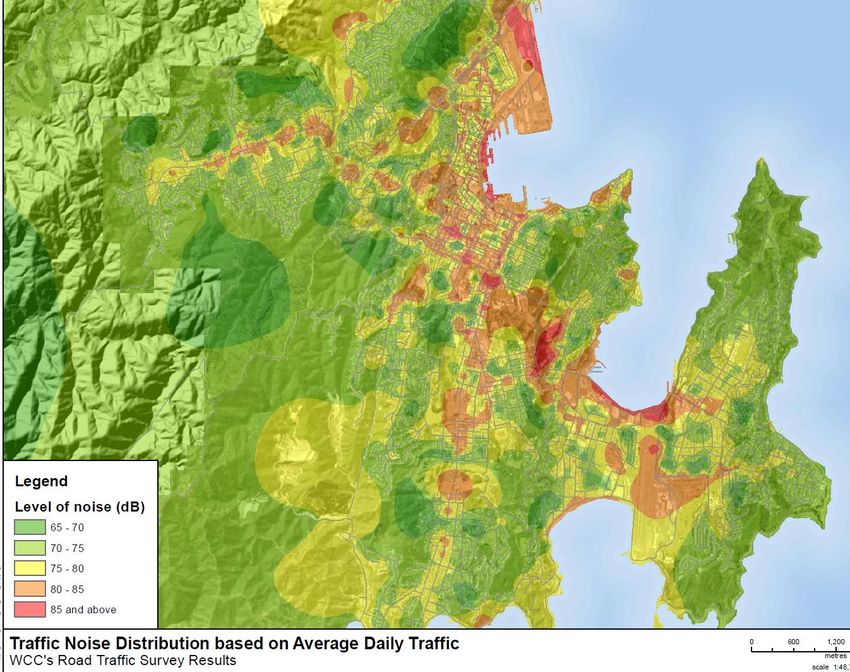
6.2.1 Noise .................................................................................................................................... 45
   6.2.2 Air quality ............................................................................................................................. 46
   6.2.3 Open spaces ......................................................................................................................... 47
   6.2.4 Vegetation ............................................................................................................................ 47
   6.2.5 Heritage................................................................................................................................ 47
   6.2.6 Visual amenity and views ..................................................................................................... 49
   6.2.7 Sense of place ...................................................................................................................... 50
6.3 Vibrancy ...................................................................................................................................... 51
6.4 Building investment .................................................................................................................... 51

                                                                                                                                                    2
Executive summary
Introduction
The purpose of the report is to spell out the current and planned land use and urban form patterns
in the Let’s Get Wellington Moving project area. The report also identifies ways the project could
influence ‘liveability’ in Wellington’s central city.
Future vision for Wellington City
A number of documents spell out Wellington’s future vision for its central city. They are:
Towards 2040: Smart Capital (2011)
Wellington Urban Growth Plan: Urban Development and Transport Strategy 2014-43 (2015)
District Plan – Central Area (2013)
Wellington Waterfront Framework (2001)
Central City Framework (2011)
A main theme of Towards 2040 is the desire for the city as a whole and the central city in particular
to be ‘people-centred’ ie to be an attractive place to live in, work in and visit, to be vibrant and to
have a strong identity and ‘sense of place’.
Another theme is for the central city to continue to drive the regional economy and to offer the
lifestyle, entertainment and amenities of a much bigger city. The compact nature of the central city
is stated as a positive feature which makes it unique among Australasian cities and is a big part of
Wellington’s attractiveness.
The Urban Growth Plan identifies the central city as a main area for residential intensification. It
promotes land use patterns that encourage active modes and the use of public transport, and
reduces pressure on resources and infrastructure. The Urban Growth Plan seeks to deliver a
compact, liveable and resilient city that is set in nature. It aims to protect the natural environment
and to minimise the impact of urban development and transport on the environment.
The District Plan identifies the importance of the Golden Mile and Cuba Street as key retail
destinations and promotes the nearby location of office activities, enhancements to the pedestrian
environment and the roll-out of quality public transport infrastructure.
The District Plan identifies the central area as a location for high quality inner city living supported by
a high quality public environment. It also encourages better accessibility between the city and the
waterfront.
The Waterfront Framework aims to bring coherence along the waterfront and to express its
connections with the city and the harbour. It contains a number of recommendations to improve the
interface between the city and the waterfront, including along the quays.
The Central City Framework contains projects related to street structure, landscape and built form. It
includes a vision to transform the main north-south streets in Te Aro into tree-lined boulevards. It
identifies Vivian Street as the only continuous east-west street in Te Aro, providing connection from
the Town Belt to Victoria University. It promotes improvements to laneways and open spaces,
amongst others.
3
Current land uses in the central city
Residential accommodation
The population of the central city has grown steadily since the 1990s. This growth partly reflected a
reduction in demand for office space in the 1990s and early 2000s, with a number of older and
lower-grade office buildings converted to apartments. It is also the consequence of new apartment
construction in the central city. Between the 2006 and 2013 censuses, the population of the central
city (ie the Te Aro, Wellington Central and Thorndon-Pipitea census areas) increased by some 4,000
residents to reach 17,000. Some 40% of all new dwellings built across Wellington City during this
period were located in Te Aro; almost all of these were apartments.
Residential development trends
The rate of residential development in the central city depends on the economic cycle and fluctuates
considerably. After the 2008 Global Financial Crisis residential development in the central and wider
city declined sharply. While increasing gradually since 2014, the number of newly consented
dwellings has yet to return to pre-GFC levels.
Other factors influencing residential development include whether the market is dominated by
investors or owners-occupiers as they tend to demand different types of products; the availability of
land; the availability of office buildings suitable for residential conversion; and land values – high
amenity apartments tend to locate on high value land (near the waterfront or the Core CBD).
Office accommodation
The Wellington office market can be broken down into three precincts: Core CBD, Thorndon and Te
Aro. The Core CBD represents the largest proportion of Wellington office space (65% of total office
space in the central city) and is where the bulk of major corporate occupiers locate. Thorndon has
traditionally been the preferred location of government departments. Te Aro is characterised by
older, lower quality office stock. Te Aro occupiers tend to be SMEs and smaller corporates in
multiple tenancies across single floors. Cheaper rents in Te Aro also attract start-up companies.
Since the early 2000’s, the majority of new office stock has been concentrated in the Core CBD, and
to a lesser extent, in Thorndon. This is reflected in the quality of office stock: Te Aro has the lowest
average quality of office space with over 80% of the stock being classed as C or D Grade.
Retail accommodation
The Golden Mile accommodates some 30% of the central area’s total retail floorspace, within over
550 stores.
The Golden Mile comprises three separate areas performing different retail functions:
The premium retail area, along Lambton Quay south of Woodward Street, attracts larger,
well-known local and international brands (eg David Jones, Whitcoulls and Glassons). This
area has high levels of foot traffic due to the surrounding concentration of CBD office
workers.
Courtenay Place is the city’s night life area and provides 25% of the city’s Bars, Pubs, Taverns
and Clubs.
The rest of the Golden Mile attracts local and national retailers, both in the goods retailing
and hospitality industries.
4
Outside the Golden Mile, retail is expanding in Cuba Street and in secondary locations, such as
Featherston Street, at the periphery of the Golden Mile.

Forecast growth
Wellington Region
The population of the Wellington Region stands at around 500,000 people with some 40% located
within Wellington City. The regional population is forecast to grow by nearly 100,000 by 2043.
Around 55% of this growth expected to be accommodated in Wellington City. The Kapiti Coast and
Porirua are forecast to accommodate about 12% of the regional growth each.

In terms of economic activity, the largest sectors in the region are Public Administration & Safety,
and Professional, Scientific & Technical Services. These two sectors contributed nearly 50% of the
total growth in GDP over the last 10 years. Those sectors of the regional economy that are driving
employment and GDP growth are more likely to be located in the Wellington CBD. Resilience and
business continuity objectives may however result in a more dispersed model of business activity
over time.

Wellington City
The population of the city is currently around 210,000. The city’s forecasters expect the population
to grow to 250,000 by 2043, at an average rate of 0.8% per year. Should the current wave of
immigration continue, the population could reach 280,000 by 2043, based on an average growth of
1.2% per annum.

The city’s population is ageing and there are more and more people living alone. By 2043, nearly
60% of all households will be singles and couples without children. Reflecting this shift, there is a
trend towards more apartment development in Wellington – these apartments are predominantly
located in the central city.

Future land uses
Wellington Region
The majority of growth outside of Wellington City will be in the form of urban expansion into
greenfield land. Porirua’s Northern Growth Area is the largest such extension, which could deliver
housing for over 7,500 people. Waikanae North is another large-scale greenfield extension planned
to accommodate over 5,200 new residents.

Some apartments and medium density housing are planned around existing urban centres, such as
Hutt Central, Petone Central and Porirua City Centre. Together, these areas could provide dwellings
for over 4,100 people.

Wellington City
The city plans to accommodate its population and economic growth through a mix of intensification
in existing urban areas and limited urban expansion into greenfield areas.

The central city is forecast to be the fastest growing area in the region over the period to 2043. The
central city comprises the census areas of Te Aro, Wellington Central and part of Thorndon-Pipitea.
Together, these three areas will accommodate some 15,650 additional residents in 2043 compared
with 2013.

                                                                                                         5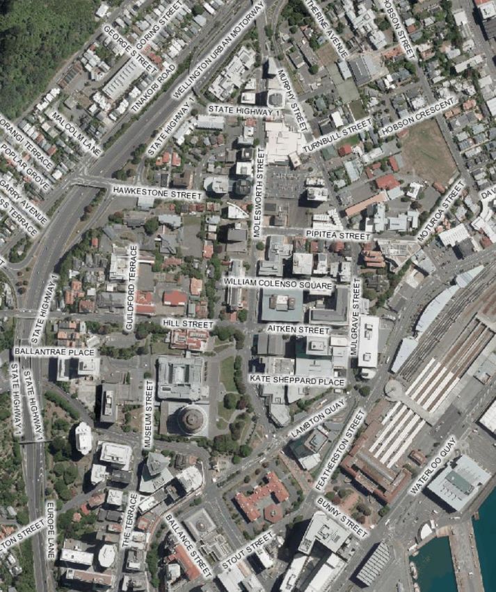
Other fast-growing areas include Lincolnshire Farm/Woodridge which is planned to accommodate
nearly 5,000 more residents by 2043 and Newtown which is expected to grow by over 4,000
residents in the same period.

In terms of employment activities, the concentration of new office buildings in the core CBD and
Thorndon is expected to continue as poorer office stock is gradually replaced with high seismic
performance stock. Central Government’s review of its office accommodation is driving investment
at the northern end of the CBD.

Retail activities are anticipated to continue to follow office workers, inner city residents and students
with the Golden Mile and Cuba Street providing the highest footfall for the foreseeable future.

Outside the central city, the Council has plans to intensify the Adelaide Road corridor, Johnsonville
town centre and Kilbirnie town centre.

Liveability
One of the four objectives of the Let’s Get Wellington Moving project is to ‘enhance the liveability of
the central city’. The last part of the document therefore seeks to define liveability in the context of
the central city. It breaks the concept down into four related topics: walkability, amenity, vibrancy
and building investment. The potential effect of the Let’s Get Wellington project on each concept is
explored.

                                                                                                        6
1. Introduction

1.1 Background
Wellington City Council, Greater Wellington Regional Council and the NZ Transport Agency are
currently investigating options for improving movement by all modes in the Ngauranga to airport
corridor. This work is known as the “Let’s Get Wellington Moving” project.

The project has wider aspirations than just delivering transport improvements. It also seeks to
increase the liveability, economic growth, safety and resilience of the central city.

1.2 Purpose of the report
The purpose of the report is to explain the current and planned land use and urban form patterns in
the Let’s Get Wellington Moving project area. By way of context, some commentary is provided on
regional population growth and current land uses activities in Wellington City outside the project
area.

The report is based on forecast population projections for the region and the city, on current
development trends and on the future vision for the city presented in Towards 2040: Smart Capital
(2011), the Wellington Urban Growth Plan: Urban Development and Transport Strategy 2014-2043
(2015), the District Plan, the Wellington Waterfront Framework (2001) and WGTN 2040: Central City
Framework (2011).

This report will help establish where change in the transport system is needed to support the
Council’s vision for the city. It will also form the baseline against which effects of the project on land
uses, urban form and liveability can be assessed.

2. Future vision for Wellington City
2.1 Towards 2040: Smart Capital
Adopted in 2011, this document sets a vision for the future of Wellington City. It aims to “position
Wellington as an internationally competitive city with a strong and diverse economy, a high quality
of life and healthy communities.” 1

The vision is supported by four goals:

•     “People-centred city
      Wellington's people are the city's greatest asset. Wellington's shape and character will continue
      to reflect the people who live in, work in, and visit the city.
      Wellington's people-centred city will be healthy, vibrant, affordable and resilient, with a strong
      sense of identity and 'place'. This will be expressed through urban form, openness and
      accessibility for its current and future populations.
•     Connected city
      As a connected city, Wellington's people, places and ideas access networks - regionally,
      nationally and globally.
      Connections will be:

1
    Towards 2040: Smart Capital (2011), WCC, page 3.

                                                                                                           7
o physical - allowing for ease of movement of people and goods
         o virtual - in the form of world-class ICT infrastructure
         o social - allowing people to connect to each other and their communities.
•   Eco-city
    Developing Wellington as an eco-city involves a proactive response to environmental challenges.
    It recognises the importance of Wellington taking an environmental leadership role as the capital
    city of clean and green New Zealand.
    Wellington's many natural assets give the city a head-start and opportunities as part of a green
    economy.
•   Dynamic central city
    As a city with a dynamic centre, Wellington will be a place of creativity, exploration and
    innovation. The central city will be a vibrant and creative place offering the lifestyle,
    entertainment and amenities of a much bigger city. The central city will continue to drive the
    regional economy”2

The document states:

“Our compact and dynamic central city, unique in Australasia, has developed over recent years into
one of the most distinctive features of Wellington, attracting people to work, live, visit and play.

It is the economic engine room of the Wellington regional economy. It is the locus for significant
culture, arts and events, which drive the success of our city. The central city provides Wellington with
many of the outstanding quality of life features [needed] to be a place where talent wants to live.”3

“Wellington’s population has the highest education levels in the country and the highest proportion
of people employed in knowledge jobs (requiring degree-level skills or higher). Our smart people are
a significant asset for Wellington, but they also present the city with a challenge – world-class skills
expect to live in a world-class city.”4

The strategy identifies the need to protect and enhance the outstanding quality of life that attracts
talent to the city and region. “Individuals and families moving to Wellington are attracted by the
unique physical and social qualities of the city: its beauty and compactness, convenience, diversity”5,
“walkability, the accessibility of arts, culture and events, the waterfront, as well as a vibrant social
scene.”6

“The mix of activity in the city is at the heart of Wellington’s vibrancy. Future growth in the city [is
expected to] continue to support mixed use – residential, commercial, entertainment, education,
parks and open spaces, and strong links to the wider city and region. [The Council intends to] develop
the streets, laneways, boulevards, built form and open spaces to reinforce Wellington as a city built
for people.”7

2
  Towards 2040: Smart Capital (2011), WCC, page11.
3
  Ibidem, page 7.
4
  Ibidem, page 9.
5
  Ibidem, page 13.
6
  Ibidem, page 33.
7
  Ibidem, page 33.

                                                                                                           8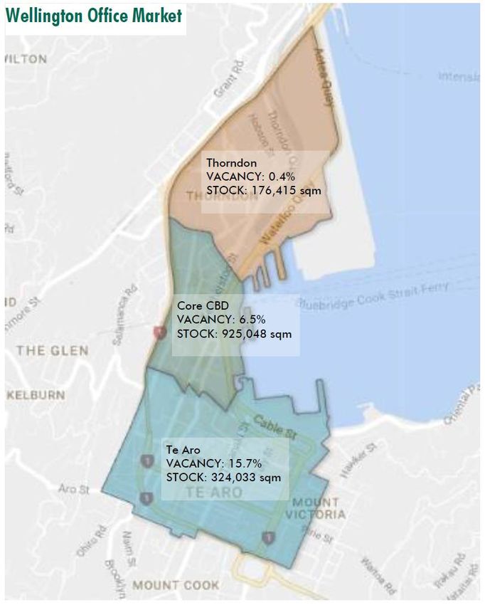
2.2 Wellington Urban Growth Plan: Urban Development and Transport
Strategy 2014-43
Adopted in 2015, the Plan is the Council’s growth management strategy.
“The objectives of the Plan are to:
Direct new growth to suitable areas to maintain the city’s compactness, liveability and
natural setting.
Ensure development occurs close to employment, services, and public and other transport
links. This will continue to encourage active modes and the use of public transport, and
reduce pressure on our resources and infrastructure. [The Council] expect most new
development to occur along the growth spine from Johnsonville through the central city to
Adelaide Road and Kilbirnie.
Improve the resilience of the city against the risk of natural hazards and climate change.
Ensure urban growth contributes to the city’s economic, social and environmental success.
Help target the Council’s investment on priority projects.
The Plan seeks to deliver the following key outcomes:
A compact city
The city’s urban areas are surrounded by the Wellington Town Belt and the reserves, rural land and
hilltops that form the Outer Green Belt. This has led to the city being compact, which is one of its
distinctive features. It also makes our city walkable and helps minimise the need for new
infrastructure. To keep Wellington compact, this plan directs future development to locations with
quality transport links, infrastructure and community facilities.
A liveable city
The central city is the main economic, social and cultural hub of the region. It is attractive, lively,
accessible and safe. At a local level, suburban centres provide a focus for community life and access
to shops and services. This plan supports vibrant centres through a range of projects.
A city set in nature
The city’s distinctive character is enhanced by protecting our natural environment, minimising the
impact of urban development on the environment and making sure people can easily get to the
waterfront and other open spaces. To achieve this, the plan emphasises the importance of better
green infrastructure such as open spaces, trees and waterways; sustainable transport options;
energy efficient buildings and water-sensitive urban design.
A resilient city
Our heritage assets, coastal areas, infrastructure networks and neighbourhoods all need to be
managed to minimise the risk of damage from natural hazards, such as earthquakes, and the effects
of climate change. This plan supports our continued leadership in identifying earthquake-prone
buildings, planning for emergencies and preparing for climate change.”8
8
Wellington Urban Growth Plan: Urban Development and Transport Strategy 2014-43 (2015), WCC, pages 12-
13.
92.3 District Plan – Central Area
The Central Area chapter of the District Plan (last amended October 2013) spells out the desired
future for the central city.
The District Plan sets a vision for a vibrant, prosperous, liveable city. At its heart is a contained
Central Area comprising a commercial core with a mix of related activities. The Plan’s Central Area
provisions are based on eight principles that will guide future development:
“Enhance the ‘sense of place’
Many qualities and characteristics contribute to the ‘sense of place’ people experience in the Central
Area. The underlying topography and landscape, and the adjacent harbour provide a memorable
backdrop to the central city. A strong identity is anchored in being the nation’s capital and a hive of
government activity; both central and local. Complementing this formal role are pockets of distinctive
character and activity. The diverse environments of the central city include high-rise towers and
offices, classic heritage buildings, character areas, the mix of public and open spaces, and harbour
views. A diverse range of people is also attracted to the array of activities on offer in the Central
Area, and they add to the flavour of the city in turn.
Enhancing this ‘sense of place’, and protecting the features that make Wellington special and unique,
are essential ingredients of a stimulating and memorable city.
Sustain the physical and economic heart of the Central Area
The city has a natural tendency towards physical containment, with an amphitheatre of hills leading
down to the inner harbour. This containment makes the city more accessible, and accentuates its
urban feel. Maintaining the strategic role of transport infrastructure leading to and from the city
centre is crucial to this goal.
Wellington’s downtown is the commercial base of the city and region. Encouraging flexible and
diverse activities will sustain the economic viability of the city centre. This includes capitalising on
cultural and recreational facilities and events the city has to offer, including the Stadium, Te Papa
and the waterfront. Ultimately this will lead to an adaptive city centre that encourages positive
growth and the city’s comparative advantage. Development in the fringes to the Central Area should
complement the vitality and viability of downtown Wellington.
Continuing to contain Central Area development will help achieve a compact, viable city centre.
Enhance the role of the ‘Golden Mile’ and ‘Cuba’
The ‘Golden Mile’ refers to the main retail and commercial strip extending from the Cenotaph near
Parliament Buildings, to the eastern end and entertainment hub of Courtenay Place. This ‘Golden
Mile’ concept reflects the natural form of the Central Area, and helps structure people’s perceptions
of the city and the way they move within it. Cuba Street is a premier pedestrian-based retail
promenade that forms an important axis with the ‘Golden Mile’.
The ‘Golden Mile’ and ‘Cuba’ will be enhanced and supported by reinforcing their key retail function,
promoting nearby office location, enhancing the pedestrian environment and improving the roll-out
of quality public transport infrastructure.
10Enhance the Central Area as a location for high quality inner city living
Increasing the amount and quality of residential dwellings will be encouraged, building on the overall
vibrancy of the Central Area and supporting the primary commercial function of downtown
Wellington and the ‘Golden Mile’.
Enhance the built form of the Central Area
The Central Area’s amphitheatre setting is enhanced by the maintenance of the compact ‘high
city’/’low city’ urban form. The ‘high city’ relates to the downtown area [between Parliament and the
Civic Centre] where most of the city’s high rise buildings are clustered. The Low City is effectively the
balance of the Central Area [Te Aro and Thorndon] where the lower buildings spread out north and
south. The lower height on the waterfront completes the stepping down from the hills to the harbour.
Enhance the quality of the public environment
The quality of the public environment helps make a city more liveable. A high quality public
environment is safe and healthy, easy to move around in, rich in quality urban design that enhances
people’s experiences, and consistent with appropriate environmental standards. The quality of the
public environment is affected by the function, location and character of public space, as well as by
the buildings and structures that define the edges of public space.
Enhance city/harbour integration
The city and sea relationship that characterises Wellington makes for a dynamic cityscape. The
waterfront is an integral and defining feature of the city. However, accessibility between the city and
the waterfront, and access to the water’s edge itself, needs to be improved so that the waterfront
becomes part of the ‘pedestrian flow’ that extends across the whole city. Better links are needed,
including physical connections and visual links such as views and signage. A promenade that
connects the different parts of the waterfront and provides a sequence of changing, rich and
interesting experiences [enhances] people’s ability to move around the waterfront itself.
Enhance the sustainability of the Central Area
Buildings and other forms of development that reduce the consumption of natural and physical
resources (including energy consumption), whilst maintaining the reasonable development
expectations of landowners will ensure that the goal of a sustainably managed city centre will be
achieved. Innovative design and construction of buildings exhibiting new principles of environmental
sustainability will be encouraged.”9
“The District Plan sets standards to guide the form of new development. However, it places minimal
direct controls over land use and the location of activities. Most activities can take place anywhere
within the Central Area, provided they meet performance standards that ensure the city’s
environmental quality is maintained.”10
“Several unique neighbourhoods and precincts crucial to the Central Area’s cultural heritage and
sense of place are identified in the Plan as heritage and character areas.”11 The heritage areas
include sites around the Parliamentary Precinct, Stout Street Precinct, Post Office Square, the former
9
Wellington City District Plan, Chapter 12 Central Area: Introduction, Objectives and Policies, pages 2-4.
10
Ibidem, page 4.
11
Ibidem.
11BNZ Head Office, Civic Centre, St John’s Church, Cuba Street and Courtenay Place. Character areas
include land along the Inner City Bypass and in the Pipitea Precinct (port office area).
The District Plan has no minimum car parking requirements for the Central Area – this has
contributed to achieving a dense urban form in the central city.
2.4 Wellington Waterfront Framework
The Wellington Waterfront Framework (2001) guides “waterfront development in a way that makes
the most of this unique and special part of the city. […] The Framework aims to bring coherence
along the waterfront and express its connections with the city and the harbour. The Framework is
based around five themes: historical and contemporary culture, city to water connections,
promenade, open space, and diversity.”12
The vision for the waterfront is: “Wellington’s Waterfront is a special place that welcomes all people
to live, work and play in the beautiful and inspiring spaces and architecture that connect our city to
the sea and protect our heritage for future generations.”13
The Framework contains performance briefs for the whole waterfront and five individual areas:
North Queens Wharf, Queens Wharf, Frank Kitts Park, Taranaki Street Wharf/Lagoon and Chaffers
area.
The ‘waterfront-wide’ part of the brief states:
• pedestrians have priority over vehicles on the waterfront
• the edge of the quays and Cable Street should be welcoming and safe; there should be
frequent, convenient and direct connections to existing streets and pedestrian ways that
adjoin the waterfront; and there should be shelter where possible
• views down city streets to the harbour and hills should be enhanced
The rest of the document provides more detail, including:
• Views of the waterfront and harbour down Whitmore, Johnston and Waring Taylor Streets
will be preserved and improved where possible. At-grade pedestrian crossing points should
be enhanced at each of these intersections.
• Queens Wharf is the heart of the waterfront. The primary symbolic entry to the waterfront
from the city is through the Queens Wharf gates.
• Thought should be given to making the Jervois Quay edge of Frank Kitts Park safer,
especially for children using the playground.
• Better and easier pedestrian access is needed to Frank Kitts Park from across Jervois Quay.
2.5 Central City Framework
The Central City Framework was adopted in 2011 and is a supporting document to Towards 2040.
The Framework contains a series of projects related to street structure, landscape and built form
which will influence the future shape of the central city. The key projects are listed below.
12
Wellington City District Plan, Chapter 12 Central Area: Introduction, Objectives and Policies, pages 4.
13
The Wellington Waterfront Framework (2001), Waterfront Leadership Group, page 11.
122.5.1 Boulevards
The City Council has a vision to transform the main north-south streets in Te Aro into tree-lined
boulevards. The idea is to improve the quality of the public realm to attract private investment in
more intensive, mixed-use developments. The three inner city boulevards identified in the
Wellington Urban Growth Plan are Victoria Street, Kent and Cambridge terraces, and Taranaki
Street. Other north-south streets of importance include Tory, Cuba and Willis streets
These streets “are important both for people and vehicles getting in and out of the city, but they are
not performing as well as they could, either as transport corridors or as pedestrian areas, largely
because:
• street blocks are too big – larger blocks mean fewer route options for pedestrians and so less
diversity of shops, cafés and other services
• there are not enough areas of interest to encourage people to stop and spend time
• poor sight lines make it hard to navigate, and break the connection between the city and the
waterfront.
In effect, these streets are merely acting as transport corridors – rather than as spaces where people
will spend time. Future improvements to these streets will:
• clarify the alignment of buildings, kerbs and footpaths
• clarify the role these streets play in connecting people and vehicles throughout the city and
form appropriate streetscape responses
• improve pedestrian spaces
• promote active uses at street level – such as shops, cafés and other uses with open doorways
and/or dynamic window displays
• provide street trees, where appropriate, transforming them into urban boulevards.”14
Tree-planting and other streetscape improvements have already taken place along Victoria Street.
This has supported development activity at Victoria Street Precinct (140 apartments at the corner of
Victoria and Ghuznee streets), the new creative campus for Whitireia WelTec and ground floor retail
on the corner of Cuba Street and Dixon Street, and planned apartment development on the
Dixon/Victoria Street corner.
Improvements along Kent and Cambridge terraces are planned to take place between 2019 and
2024 according to the city’s Long-term Plan 2015-25. “These streets have an important role to play in
relation to the Basin Reserve and the waterfront. The intention is to combine a number of the median
islands into a linear park.”15
Taranaki Street “forms part of the processional route through the city from Parliament up to
Government House [via the Pukeahu National War Memorial Park]. The vision for greening the street
will seek prioritisation of pedestrian comfort through comprehensive landscaping, paving and
lighting upgrades.”16
14
Central City Framework (2011), WCC, page 34.
15
Ibidem, page 35.
16
Ibidem.
13Taranaki Street has more complexities than the other two boulevard projects because a major
stormwater upgrade is required. This will influence the timing of the project which is currently
outside the 2015-25 Long-term Plan.
In addition to the three above-mentioned boulevards, the Central City Framework provides visions
for Willis Street (the footpath widening along the Golden Mile section was completed a few years
ago), Tory Street and Cuba Street. It states:
“Tory Street is an important street for views. Because the elevated south end is visible along the
street, it also helps people to understand the topography of Te Aro. Uneven building alignments and
encroachments make Tory Street feel ‘messy’. These will be reviewed, along with comprehensive
street landscaping, finishes, furniture and lighting. ”17
Regarding Cuba Street, the Framework states the need to protect the character of this heritage area.
Streetscape improvements are proposed to “enhance character through lighting, planting, paving
and street furniture. The incorporation of an enlarged Te Aro Park, and improvements to key lanes” 18
(Opera House Lane, Eva Street, Leeds Street – all of which have been completed in the last few
years) are also proposed.
2.5.2 East-west connectors
East-west streets in the central area can help better connect “the city to the Town Belt, waterfront,
and university campuses.
The longer East-West streets in Te Aro provide cross-valley links. […] They could function better with
clearer pedestrian connections into the Town Belt and up to Victoria University’s Kelburn campus.
These pedestrian connections, in turn, have the potential to increase the amount of pedestrian
activity into and within Te Aro. [This is proposed to] be achieved through the introduction of street
trees and shared spaces, which would enhance urban ecology and soften the cityscape, making it
more comfortable for pedestrians.
Improving the intersections and amenity of the shorter east-west streets between Lambton Quay and
the quays could provide more direct connections from the city to the waterfront.”19
“Vivian Street (adjoined by Pirie and Buller streets) provides a direct line of sight and is the only
continuous road across the valley. [Changes to this street should include] improvements to
pedestrian comfort [and] enhanced pedestrian connections at the edges to the Town Belt and
Victoria University.”20
Willeston Street “is an axis with notable heritage sites (Stewart Dawsons corner and the Old Bank
Arcade), one of the highest levels of pedestrian activity in the city” 21 and a visual link to the
waterfront. “Its potential as a short connection to the waterfront from the Golden Mile is not
17
Central City Framework (2011), WCC, page 35.
18
Ibidem.
19
Ibidem, page 36
20
Ibidem, page 37.
21
Central City Framework (2011), WCC, page 37.
14realised. This could be achieved through an improved ground level crossing point to Frank Kitts Park
and new ground level activity along the street and at the corner of Jervois Quay.”22
Waring Taylor Street “offers a clear visual connection to the waterfront. Its potential as a primary
pedestrian access route is likely to increase with developments in the Kumutoto area of the
waterfront. The physical quality of the street (ie lighting and paving) should be improved as part of
its next scheduled upgrade.”23
2.5.3 Laneways
“The central city has a number of lanes that are under-utilised, unattractive or unsafe. Lanes provide
short-cuts for pedestrians through large urban blocks and, if lined with shops, cafes and other public
uses, they can contribute to the liveliness of the city.”24
The Council has gradually been upgrading laneways, starting with Opera House Lane, Eva Street,
Leeds Street, Mason’s Lane, Cable Car Lane, Felix Lane, Egmont Street and Holland Street. These
projects are about increasing the level of economic activity and pedestrian movements along inner-
city lanes. Future laneway projects include Lombard Street, Bond Street, Garrett Street, Wigan
Street, Left Bank, and Edward Street.
2.5.4 Open spaces
“The central city is literally surrounded by nature: hills, sea and sky are dominant features of the
urban landscape. The central city itself, by contrast, is characterised by hard surfaces and little
vegetation.
[The Central City Framework] aims to introduce more green spaces […] [in the central area] including
small parks, green roofs and green links. These [are planned to] be introduced when streets are
upgraded and areas are revitalised […].
These spaces are needed because of growth in the inner-city population. Inner-city residents are
increasingly looking for comfortable spaces for relaxation and recreation. Green spaces are also
needed because of changing patterns of activity in the inner-city, for example as people use the
inner-city for exercise or to attend events and festivals.”25
The Framework proposes the re-design of a number of existing public spaces: Te Aro Park, Victoria
and Wakefield streets intersection, streets around the Lambton Quay / Hunter Street / Willis Street
block, Post Office Square and Michael Fowler car park. It also proposes upgrades of Civic Square and
Cuba Mall, a neighbourhood park in east Te Aro and a linear park between Kent and Cambridge
terraces.
2.4.5 Precincts
“Though Wellington’s central city is compact, it is also made up of a series of distinct precincts or
neighbourhoods. Each has its own character – from the region’s premier shopping high street [on
22
Ibidem.
23
Ibidem.
24
Wellington Urban Growth Plan – Implementation Plan (2015), WCC, page 19.
25
Central City Framework (2011), WCC, page 52.
15Lambton Quay], to the entertainment district around Courtenay Place, to the creativity of Cuba
Street, [to the office concentration of the core CBD] and to inner-city residential areas.”26
The Framework identifies the following precincts which require further planning and investment:
Parliamentary Precinct
This “precinct’s primary function is government. It is home to Parliament, ministries, departments
and foreign embassies. It’s also home to the judiciary, Victoria University’s Law School and cultural
institutions such as the National Library and Archives New Zealand.
Though it is busy during the day, it is relatively quiet during evenings and weekends in spite of the
presence of the Cathedral of St Paul and the addition of a number of apartment blocks in the last
decade or so. […]
This precinct’s critical function is as a centre of government, and this will continue to be the case long
into the future. […] [However,] a wider variety of uses are encouraged, so that the precinct is busy all
week round, not just during working hours. Open spaces within the precinct [should] connect it better
to Te Ahumairangi Hill (Tinakori Hill) and the waterfront.”27
Memorial Precinct
Prior to the construction of the Arras Tunnel and Pukeahu National War Memorial Park, the
Framework acknowledged the need for further planning in the area around Karo Drive and of the
Carillon.
“This area has three main functions. It acts as a transition space between the central city and
southern suburbs, provides traffic movement across the city, and is an educational area with Massey
University’s city campus, two high schools and a primary school in close proximity. It is also bordered
by nationally significant buildings such as Government House and the National War Memorial, as
well as the Basin Reserve. […]
The area has a number of characteristics that can be harnessed to make it a distinctive and desirable
neighbourhood. As an elevated area that is relatively open, it is well suited to an increase in
residential living. The creation of a National War Memorial Park [provides an open space] for
students and local residents.
Its east-west vista provides clear links between the Town Belt and Kelburn. Its proximity to Adelaide
Road – an identified area of revitalisation – will complement its growth, meaning more people will
walk and cycle through the area.”28
East Te Aro Precinct
“This precinct covers the area between Taranaki Street and Kent/Cambridge terraces. The area has a
variety of functions:
• inner-city living – over the last decade or so there has been rapid growth in the number of
residential apartments
26
Central City Framework (2011), WCC, page 64.
27
Ibidem, page 66.
28
Ibidem, page 68.
16• ‘hidden’ bars, night spots and boutiques
• destination shopping – such as large-format retail and car yards
• transit – Vivian Street and Kent and Cambridge terraces are main thoroughfares
• employment – [start-up companies], some light manufacturing, and service outlets
[…] The mix of building types and ages gives the area an urban, gritty feel, while the dominance of
low-rise buildings means that it operates on a human scale. However, the area suffers from:”29
• empty sites, used for car parking or for low intensity activities
• little greenery and very few open spaces where people can gather
• being dominated by cars – only a few areas are pedestrian friendly
• a ‘broken’ street grid which makes it difficult for people to navigate across town from east to
west.
“East Te Aro has attracted a significant amount of apartment development. This can continue, but
space also needs to be provided for [street level businesses] which will provide not only places of
work but also more lively streets. As the area becomes more densely populated, it is crucial to
improve the east-west streets and laneways to provide walking routes and protect access to sunlight
and views.
With the commercial heart of the city concentrated on the quays and [The] Terrace, Te Aro can
develop as a mixed-use inner-city neighbourhood, retaining some of its existing ‘gritty’ character
while also developing more of an urban residential feel with sustainable buildings, greener streets,
and more activity at street level.”30
Victoria / Cuba Precinct
“Cuba Street is a heritage area filled with eclectic shops, cafés and bars. It is a physical expression of
the city’s creativity, diversity and openness. […] Victoria Street, by contrast, […] [is] dominated by
cars; its primary function is one of transit across or out of the city. Unlike Cuba Street, it has many
sites that are underused or used only for parking, and very little street-level activity to encourage
pedestrian activity.”31
Victoria Street is one of the areas where the Council wants to see more people living and working in
the future so streetscape improvements were undertaken in 2015 to make it more pedestrian
friendly.
“The improvements included:
• realigning, widening and significantly improving the footpaths on both sides
• retaining the existing road width to allow for future bus and cycling improvements
• developing two new paved parks – one at the corner of Dixon Street (Volunteer Corner) and
the other, Te Niho Park, near the intersection with Vivian Street
• planting more than 55 street trees to give the street a boulevard feel
• a new southbound cycle lane
29
Central City Framework (2011), WCC, page 70.
30
Ibidem, pages 70-71.
31
Ibidem, page 72.
17• a new left-turn lane onto Vivian Street
• evening peak-hour clearways on both sides of the road between Vivian and Abel Smith
streets.”32
The upgrade supports a number of pipeline projects including new apartment complexes and the
redevelopment of the Farmers/Deka site fronting Cuba, Dixon and Victoria streets that includes a
new WelTec/Whitireia creative arts campus.
Long-term, the Council’s aspiration is for the area to become “an inner-city neighbourhood, with
quality residential buildings and space for shops and small businesses.”33 The increased residential
presence – along with the street upgrade – is expected to improve the footfall in the area and make
street-level businesses more viable.
The revitalisation of Victoria Street is expected to have positive effects (attractiveness, footfall,
safety, economic viability) on “neighbouring areas, including Cuba Street and nearby university
campuses including Victoria’s architecture school and Massey’s main campus.”34
Pipitea Precinct
“The Pipitea Precinct is a large area that includes major city infrastructure: the operational port, the
Wellington Regional Stadium, and the Railway Station. The port is a vital part of the city’s economy.
There are no known or foreseeable changes planned in its core operations in the coming decades. A
portion of port land – Harbour Quays – was deemed surplus to port operations and [developed for
office accommodation].”35
The precinct borders the Parliamentary precinct (home to Parliament, courts, government offices
and a university campus among other things), the Lambton precinct (home to offices as well as the
region’s premier shopping street) and the waterfront.
Prior to the Kaikoura earthquake, the Central City Framework’s priorities for the Pipitea precinct
were “to enhance connections between the precinct and the rest of the central city, while
maintaining the integrity of existing vital functions such as:
• moving of goods
• providing a gateway to the city for commuters and for visitors on cruise liners and ferries
• providing access to the stadium for major events that are important to civic pride.”36
The 2016 earthquake exposed vulnerabilities with reclaimed land and infrastructure along the
harbour’s edge. This is likely to change the long-term future of the office park and could affect other
port-related functions.
32
http://wellington.govt.nz/your-council/projects/victoria-street-transformation-project accessed
25/05/2017.
33
Central City Framework (2011), WCC, page 72.
34
Ibidem.
35
Ibidem, page 76.
36
Ibidem.
18Golden Mile
The Central City Framework does not mention the Golden Mile, as the programme of improvements
to the city’s prime retail route was well advanced when the Framework was prepared.
The Golden Mile runs through the central city from Courtenay Place to the railway station, including
Manners Street, Willis Street and Lambton Quay. The Golden Mile houses 30% of the central city’s
total retail offering (by floorspace) and is the main route for buses through the central area.
Over the years, the Council has invested significantly in improving pedestrians’ and public transport
users’ amenity and safety along this route. This has included widening footpaths, planting trees and
making improvements to the quality of streetscapes generally. It has also included lowering the
speed limit and adding traffic lights at key pedestrian crossing points.
At the eastern end of the Golden Mile, the Council has undertaken a complete re-design of
Courtenay Place Park; improved lighting along Courtenay Place, Allen and Blair streets; and
introduced artworks and a series of light boxes used for art exhibitions. The Council has also
supported applications for outdoor dining areas along footpaths. These various initiatives aim to
increase footfall, support local businesses and events, and make the city safer, more interesting and
more attractive.
3. Current land uses in the central city
3.1 Residential accommodation37
Wellington is seeing a significant increase in the number of people living in the inner city.
Central Wellington’s population grew substantially during the 1990s and the first half of last decade,
increasing by an average of 5.5% per annum between the 1991 and 2006 censuses. This happened at
a time when the size of the public sector was shrinking and many corporate head offices were
relocating to Auckland or Sydney.
In part, the reduction in demand for office space in Wellington contributed to growth in the inner
city’s population, with a number of older and lower-grade office buildings being converted to
apartments. The increased number of people living in the central city also flowed through into
demand for a more diverse range of retail facilities and a large number of entertainment options.
After the Christchurch earthquakes in 2011, Wellington’s office market went through another
transitional phase, with strong demand for space in high-grade and seismically safe buildings, while
lower-grade buildings struggled to attract or retain tenants. The surplus of lower-grade space
became even greater in the first half of 2016 as government departments continued their process of
consolidation, moving into refurbished and upgraded premises. This surplus was reversed after the
November 2016 Kaikoura earthquake with vacant office buildings filling up with displaced office
tenants (see office accommodation, below).
37
Source: Regional Hotspots 2016 (November 2016), Infometrics
19Central Wellington’s population grew by 6.1% in the June 2016 year, supported by new apartment
construction and office conversions. This activity is particularly concentrated in Te Aro, although the
Lambton and Thorndon areas also experience significant population growth.
Increasing tertiary student numbers in Wellington also contribute to growth in the inner-city
population. Victoria University has been steadily increasing its number of hostels over recent years,
and the opening of the Whitireia-WelTec campus on Cuba Street will also add to student numbers in
Central Wellington.
The Census population of Central Wellington (Te Aro, Wellington Central and Thorndon-Pipitea) was
16,881 in 2013, an increase of 4,008 over the 2006 Census. This comprised 9,654 residents in Te Aro
(2,742 more than in 2006), 2,958 residents in Wellington Central (an increase of 906 from 2006) and
4,269 residents in Thorndon-Pipitea (a gain of 360 from 2006).
Census unit 2006 2006 2013 2013 Change Change
Population Dwellings Population Dwellings Population Dwellings
Te Aro 6,912 3,066 9,654 4,665 +2,742 +1,599
Wellington Central 2,052 1,362 2,958 1,356 +906 -6
Thorndon-Pipitea 3,909 2,175 4,269 2,226 +360 +51
Total 12,873 6,603 16,881 8,247 +4,008 +1,644
Table 1: Population and dwellings in Wellington Central Area 2006 & 2013. Source: ID Profile
Te Aro added some 1,600 new dwellings to its residential property portfolio between the two
Censuses. By comparison, the city as a whole gained 4,100 dwellings during the same period. This
means that some 40% of all new dwellings in Wellington were developed in Te Aro in the 2006-13
period.38 The vast majority of these units were studios, one and two bedroom apartments. This
reflects the population profile of the area which has a heavy representation of tertiary education
students (18 to 24 years olds make up 39% of Te Aro residents compared to 14% for the city as a
whole) and young workers (25 to 34 year olds make up 31% of Te Aro’s population but only 17% of
the city’s population).
Figure 1: Consented Dwellings by Suburb 2006-2016. Source: WCC
The above graph shows the disparity between the rate of development in Te Aro and the other
suburbs of Wellington. In the ten years to 2016, Te Aro was growing at over three times the rate of
the next fastest growing suburbs.
38
ID Profile, http://profile.idnz.co.nz/wellington/dwellings?WebID=10&BMID=10, accessed 24 May 2017
20You can also read