Applying Google Maps and Google Street View in criminological research
←
→
Page content transcription
If your browser does not render page correctly, please read the page content below
Vandeviver Crime Science 2014, 3:13
http://www.crimesciencejournal.com/content/3/1/13

 SYSTEMATIC REVIEW                                                                                                                                 Open Access

Applying Google Maps and Google Street View in
criminological research
Christophe Vandeviver

  Abstract
  Online mapping technologies such as Google Maps and Street View have become increasingly accessible. These
  technologies have many convenient uses in everyday life, but law enforcement agencies have expressed concern
  that they could be exploited by offenders and might alter existing offending patterns and habits. For environmental
  criminologists, they have the potential to open up new approaches to conducting research. This paper draws on the
  results of earlier studies in related fields and a handful of criminological studies to discuss how these online mapping
  applications can trigger new research questions, and how they could be considered a valuable methodological
  addition to criminological research.
  Keywords: Google Maps; Street View; Environmental criminology; Innovation; Methodology; Methods

Introduction                                                                            to environmental criminological research, and this
Although Google Maps and Street View have not been                                      article considers how they might be implemented in
developed with scientific research in mind, they create                                 future criminological research. Drawing on previous
interesting possibilities for research. Several scientific                              criminological applications, I discuss how the availability
disciplines were quick to implement these web mapping                                   of Google Maps and Street View can generate new
applications in their research. For instance, geographers                               research questions; and how they could be considered
rely on aerial photography from Google Maps as an alter-                                important additions to the methodological toolkit of
native to expensive commercial satellite imagery (Pringle                               criminologists.
2010) and biologists tap into Street View imagery to                                      This article is structured as follows. First, some back-
assess the habitat of certain animal species (Olea and                                  ground information on Google Maps and Street View is
Mateo-Tomás 2013). However, while there are abundant                                    provided, and the existing literature in relation to their
examples of studies that apply Google Maps and Street                                   application in related fields and previous studies is
View in related scientific fields, only a few crimino-                                  reviewed. Next, several potential uses for these online
logical studies have tapped into the power of online                                    mapping technologies in environmental criminological
mapping technologies for research purposes. Whereas                                     research are explored. Third, their advantages and
the general public, offenders and law enforcement agen-                                 drawbacks are discussed. Fourth, readers are provided
cies have already discovered the power of these online                                  with an outline of where to find additional information
mapping services and use them daily, criminologists,                                    on how to use these mapping technologies. Fifth, an
somewhat surprisingly, seem not to have fully discov-                                   interesting future development of environmental crim-
ered the advantages of using Google Maps and Street                                     inological research that is rooted in the availability of
View in their research. In this article I argue that the                                web mapping technologies is identified, and finally
proliferation of online mapping technologies opens up                                   several suggestions for further reading are provided.
several new approaches for criminologists to conduct
environmental criminological research in particular. A                                  Background
small number of criminological studies have already                                     An introduction to Google Maps and Street View
shown that these technologies can be a valuable addition                                Google Maps
                                                                                        Originally launched in 2005, Google Maps (Google 2014c)
Correspondence: Christophe.Vandeviver@UGent.be                                          is a free-to-use, web-based mapping service that combines
Institute for International Research on Criminal Policy, Ghent University,
Universiteitstraat 4, Ghent (9000), Belgium

                                         © 2014 Vandeviver; licensee Springer. This is an Open Access article distributed under the terms of the Creative Commons
                                         Attribution License (http://creativecommons.org/licenses/by/4.0), which permits unrestricted use, distribution, and reproduction
                                         in any medium, provided the original work is properly credited.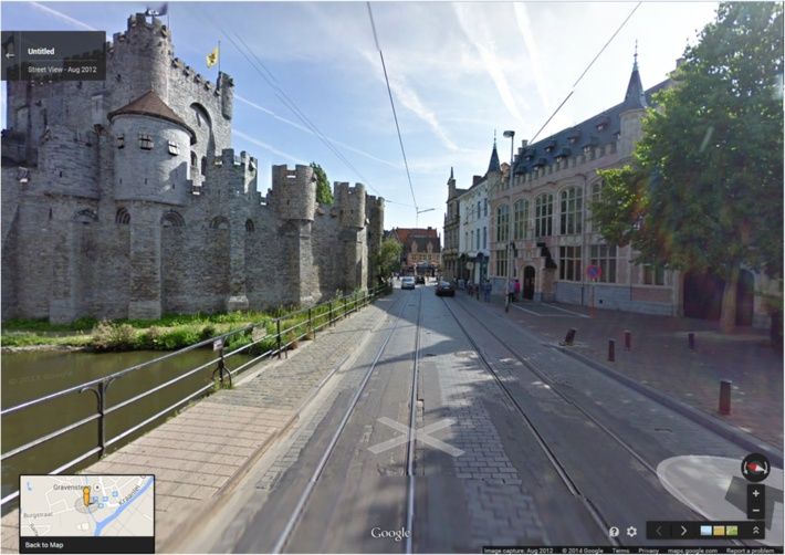
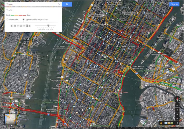
Vandeviver Crime Science 2014, 3:13                                                                                        Page 2 of 16
http://www.crimesciencejournal.com/content/3/1/13

conventional cartographic maps with satellite imagery and                such as places, labels, photos, and videos to the under-
high-resolution aerial photography. The maps are embed-                  lying Google Maps map. Moreover, users can draw lines,
ded with additional information on terrain, street and road              shapes and patterns directly on the map, add directions,
names, famous landmarks and buildings, public transit,                   and organize and compare up to three different datasets.
real-time and typical traffic information. Users can con-                Once created, custom maps can be shared and users can
veniently switch between map and satellite view, or opt                  work together to create a collaborative custom map.
for a hybrid view that overlays the information available in               Google Maps has considerably simplified looking up
the map view onto the satellite view (see Figure 1). For a               addresses, and has made mapping and cartography
number of cities worldwide, 45° aerial imagery is available              accessible to the masses. Over a billion users access
allowing users to get a better understanding of the size                 Google Maps and its related services such as Street
and proportions of buildings as well as observe certain                  View on a monthly basis (Choudhary 2013) and the
landmarks from four different perspectives.                              Google Maps mobile app is used at least once a month
   The available aerial imagery is generally believed to be              by more than one in two smartphone users, making it
no older than three years and is updated on a regular                    the most popular smartphone app worldwide (Smith
basis. Users can update the map data in real time using                  2013). Essentially, Google Maps is an easy-to-use mapping
Google Map Maker (Google 2014b) and, following                           application that allows its users to locate addresses quickly,
approval, these updates are implemented in Google                        and provides cartographic maps augmented with digital
Maps (Sridharan 2011). The underlying aerial imagery                     information and high-resolution aerial imagery.
database also powers Google Earth, a downloadable
geographical information program with similar function-                  Street View
alities to Google Maps that allows users to access map                   Street Viewa is a service available in Google Maps that
data from their desktop. Three-dimensional mapping                       supplements the original two-dimensional map view of
was also made available in Google Maps in late 2011                      Google Maps with three-dimensional, 360° street-level
(McClendon 2011).                                                        panoramic imagery (see Figure 2). Launched in 2007
   Additional services that are available in Google Maps                 in a handful of U.S. cities, Street View currently covers
include Street View, a route planner for driving, public                 locations on all seven continents (Google 2014j). Almost
transit, walking and bicycling, and a business locator.                  total coverage has been achieved in North America,
Users are also able to create and share custom maps                      Australia, Japan and most countries in Europe. Additional
(Liebert 2013). The custom maps environment (Google                      Street View imagery is currently being collected in a range
2014g) allows users to add additional layers of content                  of countries.

 Figure 1 Example of hybrid map view with typical traffic information.
Vandeviver Crime Science 2014, 3:13                                                                           Page 3 of 16
http://www.crimesciencejournal.com/content/3/1/13

 Figure 2 Example of Street View image.

  Street View imagery is captured through a diverse fleet      as far back as 2007 (Shet 2014). Moreover, in a limited
of vehicles equipped with specialist cameras (Vincent          number of cities users can virtually visit businesses
2007). After collection, photos are digitally processed        participating in the Business Photos program (Chang
and ‘stitched’ together to obtain the familiar 360° pano-      2013). Essentially, Street View allows users to explore
ramas. These images are connected to the Google Maps           the real world virtually, without losing the underlying
map and embedded with information on the street name           map context provided by Google Maps (Vincent 2007).
and the approximate address. To protect the privacy of
bystanders that are inadvertently captured on camera,
                                                               Google Maps and Street View in scientific research
faces and license plates are pixelated (Google 2014h).
                                                               Web mapping technologies have been embraced by
Users can make additional requests for blurring out
                                                               disciplines such as geography, archaeology and ecology,
images that feature the user, their family, their home or
                                                               but also by several social scientific disciplines. Regard-
their car, and have tools available to request the removal
                                                               less of the discipline, two particular applications can
of inappropriate or sensitive images.
                                                               generally be distinguished. First, Google Maps and
  The majority of images currently captured by the
                                                               Street View have been implemented as convenient tools
Street View fleet is of near high-definition quality (Cawley
                                                               to reduce the costs and expertise needed to conduct
2010). Up to September 2010 the images being collected
                                                               research. Second, a smaller number of studies have
were low resolution, and some areas can therefore only be
                                                               shifted their focus towards these applications and
experienced in Street View in low-resolution quality. In
                                                               treat them as full-grown research subjects in their
time, the low-resolution imagery will be replaced with
                                                               own right, generating new and significant research
higher-resolution photos. Although Street View imagery
                                                               questions.
is intermittently updated and higher-resolution imagery
is made available whenever possible, it is unclear how
regularly these updates occur. Users can also update the       Geography, archaeology, and ecology
available imagery themselves or supplement it by creating      Researchers working in the disciplines of geography,
immersive 360° views called ‘photo spheres’ (Rapoport          archaeology, and ecology quickly incorporated web-
2013). Once these individual spheres are connected and         based mapping technologies into their research designs,
uploaded to Street View, other users can navigate them         and did so on a relatively large scale. Google Maps in
just like they would navigate Street View. As of April         particular has been implemented in a diverse range of
2014, users have the option to go back in time and explore     studies, although applications of Street View remain
historical imagery from past Street View collections dating    more limited.
Vandeviver Crime Science 2014, 3:13 Page 4 of 16 http://www.crimesciencejournal.com/content/3/1/13 The freely available satellite images from the Google assessed the quality of the information contained in Maps database have primarily served as inexpensive Google Maps and Street View (Paradiso 2013; Davis and alternatives to costly commercial satellite imagery. While de Alencar 2011; Wai Yeung et al. 2013). Attention has remote sensing and the use of satellite images are not new also been paid to the usability of web mapping applica- in scientific research (e.g., Mertens and Lambin 2000), the tions from a user’s perspective (Nivala et al. 2008). costs and necessary technical expertise required to apply these methods have certainly been reduced with the wide- The social sciences spread availability of easy-to-use and inexpensive online The social sciences have also embraced web mapping mapping applications such as Google Maps (Pringle 2010; technologies, albeit somewhat later and on a smaller Kennedy and Bishop 2011). Areas that were previously scale than the disciplines mentioned above. While appli- considered too remote or too expensive to access in cations of Google Maps remain relatively limited in the person can now be relatively easily surveyed from the social sciences, Street View has been implemented in a researcher’s computer (Myers 2010; Pringle 2010). For host of studies and has the potential to become a useful instance, the Google Maps satellite imagery database has tool for quickly collecting large amounts of data on the been used to scan large parts of the Arabian peninsula for built and social environment (Sampson 2013). prehistoric ruins and structures (Kennedy 2011; Kempe Google Maps is predominantly being applied as a tool and Al-Malabeh 2013), to obtain better estimates of fish to visualize data. It is only sporadically used as a source catches in the Persian Gulf (Al-Abdulrazzak and Pauly of geographically relevant information. It has, for 2013), and to estimate forestry biomass in India (Ploton instance, been used to map the spatial distribution et al. 2011). Other studies have tapped into the Google and interconnectedness of scientific output (Leydesdorff Maps satellite imagery database to map the glacial geo- and Bornmann 2012; Bornmann et al. 2014; Leydesdorff morphology of the central Tibetan plateau (Morén et al. and Persson 2010) and to geo-reference poetry in urban 2011), and the English Lake District (Brown et al. 2011). spaces (Berry and Goodwin 2013). Yet there are examples There are also examples of some rather less con- of more innovative applications. Psychologists have used ventional applications of online mapping technology. Google Maps to collect information on places visited by Archaeologists have examined Google’s satellite images participants in a study on daily activity (Wolf et al. 2013). to chart the growth of the Guantánamo Bay prison In addition to keeping a diary of places they visited during complex, and have provided the public with an inde- the study and being monitored via GPS, participants were pendent map of the prison camp (Myers 2010). Simi- required to pinpoint the places they visited in Google larly, by analyzing satellite images from the aerial Maps. Google Maps can also be a particularly powerful imagery database underlying Google Maps, the looting tool to nurture crowdsourced and crowdcasted science, of archaeological sites across the world has been by letting users create and share maps embedded with tracked in order to provide a better understanding of information on their environment (Hudson-Smith et al. the scale and impact of the problem (Contreras 2010; 2009; Kindynis 2014; Lefer et al. 2008). Thanks to such Contreras and Brodie 2010). Other examples include initiatives, social scientists and the general public alike studies that used Google Maps to support and map the are now able to collect, visualize and share vast amounts process of collaborative spatial decision-making (Rinner of data (Hudson-Smith et al. 2009) ranging from popu- et al. 2008) or to collect spatial information from partici- lation density (e.g., LondonProfiler.org), to the number pants filling in an online questionnaire (Bearman and of violent crimes in a particular area (e.g., maps.met. Appleton 2012; Snizek et al. 2013). police.uk), to the geography of America’s prison industry Although the number of studies that have implemented (e.g., prisonmap.com). Street View so far is limited, Street View has particular A large number of public health studies have looked advantages for research and is considered a novel and into the suitability of studying Street View imagery in convenient way of obtaining environmental information. order to collect data on the built environment. In general, Examples include studies in which Street View imagery was their results suggest that virtually auditing a particular a source of information that allowed the habitat of certain neighborhood is a reliable, cost- and time-effective alter- animal species to be assessed (Olea and Mateo-Tomás native to actual on-site visits (cf. inter alia Ben-Joseph 2013), or where it served as a tool to map the spatial distri- et al. 2013; Badland et al. 2010; Clarke et al. 2010). bution of a particular population (Rousselet et al. 2013; Finally, the substantive aspects of the technology have Gordon and Janzen 2013) or to obtain information on also been explored. Studies have looked into how Google pedestrian and road infrastructure (Hanson et al. 2013; Maps is being used by students (García-Martín and Guo 2013). García-Sánchez 2013) and the merits it has as a didactic Lastly, some studies have focused on the online mapping tool in educational settings (Ovidia 2012; Patterson 2007). technologies themselves. These studies have principally The development of Google Maps has been studied from
Vandeviver Crime Science 2014, 3:13                                                                             Page 5 of 16
http://www.crimesciencejournal.com/content/3/1/13

a political-economic perspective and its implementation        law enforcement agencies and former burglars share a
has been situated within a historical and broader socioeco-    concern that the availability of Google Maps and Street
nomic context (Lee 2010). Street View has also received        View helps burglars to prepare for their offenses. It is
substantial attention. The way that Street View represents     exactly this concern that Van Daele et al. (2012) scruti-
stigmatized neighborhoods and might contribute to their        nized in a study that examined whether burglars are
stigmatization has been criticized (Power et al. 2013).        likely to rely on online mapping technologies to select a
Other scholars have looked into how the implementation         suitable target.
of Street View sparked privacy concerns (Geissler 2011)           Van Daele et al. (2012) set out to examine whether the
and redefined our perception of privacy (Elwood and            proliferation of online mapping technologies might
Leszczynski 2011).                                             contribute to burglary and alter known burglary pat-
                                                               terns. First, they explored whether it is likely or not
Google Maps and Street View in environmental                   that burglars rely on Google Maps and Street View to
criminological research                                        search for potential targets. Burglars look for targets in
Only a handful of criminological studies have so far           their awareness space (Brantingham and Brantingham
implemented Google Maps and Street View in one way             1981). Before the advent of web-based mapping tools,
or another in their research designs. This is somewhat         this awareness space was established while performing
surprising, since the general public, offenders and law        routine activities such as traveling to work or visiting
enforcement agencies have already discovered the advan-        friends. This required burglars to visit potential targets
tages online mapping technology offers in their daily life     beforehand. Now, however, by browsing through Google
and work. Iraqi and Palestinian militants have admitted to     Maps and Street View burglars can become aware of
using web-based mapping applications to select possible        previously unknown areas and case potential targets.
targets for terrorist attacks (Levinson 2007). Similarly,      Since Google Maps and Street View enable armchair ex-
graffiti writers and shoplifters in London were found to       ploration (McClendon 2010), the burglar’s awareness
use Street View to look for new targets (Kindynis 2014).       space and the number of potential targets are potentially
Burglars are believed to ‘google’ for potential targets and    vastly expanded.
may be using online mapping technologies when casing              Second, Van Daele et al. (2012) examined whether the
homes for break-ins (Michaels 2011). Householders also         use of Street View makes burglars rely on different tar-
believe Street View might contribute to burglary (The          get characteristics than when they select a suitable target
Telegraph 2010; Pyatt 2009; Power et al. 2013), a concern      on the street. Burglars are known to exhibit some degree
that is shared by ex-burglars (Sterling 2011) and police       of planning (Bennett and Wright 1984) and pay atten-
unions (De Tijd 2011) alike. Interestingly, these applica-     tion to characteristics of the built environment when
tions also offer law enforcement agencies the opportunityb     selecting a suitable target (Nee and Meenaghan 2006;
to establish new forms of surveillance and crime control       Palmer et al. 2002). Target characteristics are typically
(Kindynis 2014), while simultaneously empowering ordin-        observed while walking down the street, but can also be
ary citizens by providing them with new tools to control       assessed through the imagery available in Street View.
law enforcement agencies (EURONEWS 2013) or give               Van Daele et al. (2012) therefore argued that it would be
expression to their concerns about crime (Hudson-Smith         logical for burglars to rely on such tools during the
et al. 2009).                                                  planning stage, since it potentially decreases the costs of
  For the few criminological studies that have imple-          a burglary by reducing preliminary travel costs and the
mented Google Maps and Street View in their research           risks associated with casing a potential target. However,
design, online mapping technologies have either been           it remains unclear whether the nature of the type of
the object of criminological enquiry or have been used         images in Street View (e.g., snapshot, image quality,
as a methodological tool to help researchers reduce costs      limited zoom possibility) actually allows them to carry
and overcome particular difficulties in their research.        out a detailed assessment of the suitability of a house as
Drawing on these studies, I discuss two major aspects of       a burglary target.
Google Maps and Street View in relation to environmental          To answer their research questions, Van Daele et al.
criminological research, namely: how these online map-         (2012) recruited undergraduate criminology students
ping applications can generate new research questions;         who were instructed to select a characteristic burglary
and how they could be considered an important addition         target and to give at least three reasons why it is suitable.
to the criminologist’s methodological toolkit.                 A quarter of the participants were not given additional
                                                               instructions and could select their target as they saw fit.
Mapping out new research questions                             The rationale for this choice was to see whether partici-
Web-based mapping technologies could themselves con-           pants would spontaneously use web mapping technologies
stitute the object of criminological enquiry — for instance,   in their search. A quarter of the participants were asked to
Vandeviver Crime Science 2014, 3:13 Page 6 of 16 http://www.crimesciencejournal.com/content/3/1/13 select their target on the streets, another quarter was used when looking for targets. The introduction of Street ordered to only use Google Maps and Street View and a View in an area closely resembles a natural experiment final quarter was also limited to Google Maps and Street and offers the opportunity to conduct observational View but had to take a photograph of the selected house research. Other potential research questions that could as well. This photograph was added to make the situation be addressed are, for instance, whether homeowners correspond more closely to an actual burglary. After all, decide to pixelate their house in Street View in antici- when a burglar has selected a potential target on Google pation of or in reaction to burglary victimization and Maps he still has to visit the house to burglarize it. how is this related to their perceived fear of crime? Regarding their first research question, Van Daele How homeowners’ decisions to pixelate their house et al. (2012) conclude that it is fairly unlikely that affect the chance of burglary victimization? Further- burglars would make use of Google Maps and Street more, how does offenders’ online searching behavior View on a large scale. Participants that were not given affect their offline target selection process: does their additional instructions on how to select a target did not offline awareness space guide their online searching use these applications spontaneously when looking for behavior or do offenders become familiar with previ- targets. Moreover, the participants that used Google ously unknown areas through their online searching Maps and Street View predominantly used them to behavior? Does the introduction of Street View in an assess targets in areas they were already familiar with. area affect local crime figures? Finally, the recent avail- The availability of online mapping technologies did not ability of a time-travelling option in Street View offers result in participants looking for targets outside their researchers a chance to study the effect of changes in awareness space. In other words, participants did not features of houses, streets or neighbourhoods on local randomly explore Google Maps and Street View until crime figures and crime prevention policies. they came across a suitable target. Their pre-established awareness space guided their use of the web mapping An important addition to the methodological toolkit applications and determined where they looked for In addition to the research questions online mapping tech- targets in these online tools. In addition, the require- nologies might trigger, their availability is a boon to criminol- ment to take a photograph of the proposed target made ogists and Google Maps and Street View could become participants predominantly look for targets near their powerful methodological tools in criminological research starting point (Van Daele et al. 2012). (Kindynis 2014). First, they enable environmental criminol- Van Daele et al. (2012) also found that participants ogists to collect data on the physical environment, often in who used Street View to select a suitable target did not a cost- and time-efficient manner. Using Google Maps in rely on different target characteristics to participants environmental criminological research might allow re- who selected targets on the street. Interestingly, partici- searchers to address some of the drawbacks related to using pants who used Google Maps and Street View to select conventional maps, and Street View seems to be particu- a target paid a considerable amount of attention to the larly helpful as a tool to remotely collect data on the built level of accessibility of the neighborhood and street in environment. Moreover, the many underlying application which the target is located, although they did not pay programming interfaces (API) could reduce the resources significantly more attention to accessibility than partici- required to obtain certain types of information. pants that did not use Google Maps and Street View. Second, the proliferation of online mapping technologies While this study has its limitations — for instance, it allows to reconsider established practices in environmental is unclear to what extent participants possessed the same criminological research. Moreover, Google Maps consti- level of experience in using web mapping applications tutes a helpful tool to visualize environmental crimino- and whether non-burglars such as criminology students logical data and make research results easily accessible can replicate burglars’ decisions on potential targets to a broad audience. (Garcia-Retamero and Dhami 2009; Nee and Meenaghan 2006) — the setup is novel and its conclusions are inter- Data collection esting. Moreover, it is, to my knowledge, the only study Google maps and conventional maps Conventional that has explored how contemporary web mapping tech- maps have often been used in criminological research to nologies affect crime, and is a prime example of how collect data. They are particularly powerful data-gathering Google Maps and Street View could become the object instruments when interviewing offenders and can be used of more criminological enquiry. The experiment could to collect information (Summers et al. 2010). Yet using potentially be re-created using convicted burglars as conventional maps has its disadvantages, and some of subjects, to gain insight into how they make use of these these could be addressed by using Google Maps. tools, or the experiment could implement additional soft- Summers et al. (2010) discuss in detail how conventional ware that tracks how web-based mapping technologies are maps such as hand-drawn sketch maps and standard
Vandeviver Crime Science 2014, 3:13                                                                              Page 7 of 16
http://www.crimesciencejournal.com/content/3/1/13

cartographic maps can be used during offender interviews        affect human behavior (Bottoms and Wiles 1997). A
to tap into information that might not otherwise be             variety of methods for obtaining data on the built envir-
revealed. They allow researchers to collect information on      onment are at the researcher’s disposal, such as self-
the spatial awareness of offenders, explore their activity      report surveys, census data, and neighborhood audits
patterns and look into the spatial distribution of their        (Rundle et al. 2011). Neighborhood audits, or system-
offenses (see also Canter and Hodge 2000). Sketch maps          atic social observations, are completed in person and
drawn by hand are valuable instruments to tap into              on site by trained observers (e.g., inter alia Sampson
offenders’ knowledge of their physical environment and          and Raudenbush 1999; Day et al. 2006; Clifton et al.
the offenses that take place there (Canter and Hodge            2007; Brownson et al. 2004). They allow a researcher to
2000). Conventionally, researchers obtain these maps by         precisely define the theoretically relevant variables, and
providing offenders with a pencil and paper and asking          assess the reliability and validity of the measures. How-
them to draw a map of the areas they are familiar with and      ever, large-scale projects are often unfeasible (for a
committed their offenses in. The outcome of researchers’        notable exception see Sampson and Raudenbush 1999)
requests to draw a sketch map is dependent on a range of        because of the costs and time required to travel to the
factors, such as offenders’ ability to understand the task,     study area and conduct the audit (Rundle et al. 2011;
and the size of the paper provided (Canter and Hodge            Ben-Joseph et al. 2013). Moreover, residents may
2000; Summers et al. 2010). The size of paper, for instance,    perceive such audits as invasive (Caughy et al. 2001). A
might limit the amount of information that an offender is       virtual audit of the study area might offer a solution to
able to include in a sketch map. Moreover, offenders vary       some of the drawbacks inherent to on-site audits.
in their drawing ability and it is sometimes particularly       When carrying out a virtual audit, observers will not
difficult for researchers to assess the accuracy of a           travel to the study area in person but will instead
hand-drawn map and relate it to the cartographic map            browse through the available Street View imagery and
of the area (Summers et al. 2010). Interestingly, carto-        virtually walk through the targeted area as they would
graphic maps are not often used by researchers when             when visiting the area in person.
interviewing offenders, possibly because of the difficulty        A number of public health studies have already looked
of selecting the correct scale of map — the map needs           into the opportunities that Street View offers for collect-
to cover a large enough geographical area yet still be          ing data on the built environment, and confirm that
readable (Summers et al. 2010). Even when researchers           audits using Street View imagery offer a convenient and
have given considerable thought to the scale of a map, it       reliable alternative to on-site audits (Wilson and Kelly
might still be too small or not detailed enough to elicit all   2011; Wilson et al. 2012; Kelly et al. 2013; Ben-Joseph
the relevant information during an offender interview.          et al. 2013; Odgers et al. 2012; Badland et al. 2010;
   The Google Maps environment offers a solution to             Clarke et al. 2010; Taylor et al. 2011; Rundle et al. 2011;
some of these limitations. In a way, Google’s custom maps       Griew et al. 2013; Kronkvist 2013). The results obtained
allow users to combine sketch maps with cartographic            through Street View are generally valid and consistently
maps. Users can add layers of information to these              show acceptable levels of reliability. Street View also
customized cartographic maps and can use the styling            offers the potential to greatly reduce costs and time,
and drawing options to demonstrate underlying pat-              since the need to travel to the study area is eliminated
terns or add context where needed. This information             (Odgers et al. 2012; Badland et al. 2010; Clarke et al.
can be directly related to the underlying cartographic          2010; Taylor et al. 2011; Rundle et al. 2011; Griew et al.
map, making it easier for researchers to understand             2013; Kronkvist 2013). Furthermore, researchers have
how the sketch map is related to the context of the             the added convenience that the study area can be
underlying cartographic map. Moreover, users can freely         re-visited whenever needed — for instance, when more
change the scale of the Google Maps map, making the             data needs to be collected or when additional supervision
map’s scale less important and eliminating the limita-          or quality control is needed during the data collection
tion that the size of the paper introduces to hand-drawn        phase (Clarke et al. 2010; Rundle et al. 2011). In addition,
maps. Obviously, using Google Maps will not affect an           these measurements do not have an impact on local resi-
offender’s drawing ability and researchers will still need      dents (Rundle et al. 2011).
to assure participants that they are interested in the            The major disadvantage of using Street View in envir-
information contained in the sketch maps and not in             onmental audits is that small-scale items, such as the
how the maps look (Summers et al. 2010).                        presence of cigarette butts or the condition of sidewalks,
                                                                cannot be reliably measured, and more qualitative assess-
Street view and neighborhood audits Environmental               ments relating to the social environment, such as the
criminologists have shown, and continue to show, an             general level of social disorder, are not accurately
interest in how physical features of the environment            assessed (Kelly et al. 2013; Ben-Joseph et al. 2013; Wilson
Vandeviver Crime Science 2014, 3:13 Page 8 of 16 http://www.crimesciencejournal.com/content/3/1/13 et al. 2012; Odgers et al. 2012; Rundle et al. 2011; Clarke social features on burglary victimization used Street View et al. 2010; Griew et al. 2013; Kronkvist 2013). Moreover, to virtually assess design features of houses (Apps 2012). it is often unclear whether the images accurately reflect The results from all these studies support the idea that the current on-site situation. The timing of the recording Street View is a reliable tool to collect data on a range may confound what can be seen. This is especially true of environmental characteristics and that it can be used for environmental features that are subject to temporal successfully in an environmental criminological setting. variability (Coupe and Blake 2006; Nee and Taylor 2000; Fujita 2011), such as shrubbery and hedges, the pres- Google Maps API Researchers that want to get more ence of cars on the street and driveway, and whether out of Google Maps and Street View than the visual shutters are closed or lights around the house are on. interface offers, might want to consider using one of the Finally, the quality of the images sometimes prohibits many underlying APIs. These require researchers to reliable assessments of detailed features of the built have a basic understanding of programming but allow environment (Ben-Joseph et al. 2013; Badland et al. them to perform a variety of time and resource intensive 2010; Taylor et al. 2011; Kronkvist 2013). tasks relatively easily and without cost. For instance, Notwithstanding these disadvantages, it is a promising researchers can use the Geocoding API to easily convert and viable alternative to on-site audits that can be used address information into precise geographic coordinates in several ways. For instance, researchers could combine that can then be plotted on a map or vice versa. The online and offline audits in their research design. Initially, Places API allows to query the Google database for place online audits could be used to cover a large area, and save information on a variety of categories such as businesses money and time. In a follow-up phase, researchers could and schools. The result is a list of summary information uses those resources to actually visit the study area. including location, business hours and price categories. Small-scale items could then be accurately measured More comprehensive information about a particular and the social environment could be qualitatively place can be accessed by using the Place Details API. assessed. Moreover, online mapping technologies could Journey-to-crime researchers will be particularly inter- also be used on-site, while the audit is conducted. Since ested in the Directions API and the Distance Matrix Google Maps is available on smartphones and tablets, API. The former API lets users calculate directions researchers could quickly consult Google Maps to rate between a set of locations for a range of transport certain house features without intruding on the occu- modes including driving and walking. The latter API pants’ privacy (e.g., Does the house have a backyard? provides recommended travel distances and times for a How large is the house? Does the garden border other matrix of address locations. Google’s API picker (Google gardens?) or access Street View images and make use of 2014l) provides a comprehensive overview of the available the time-travelling option to check what the street looks APIs and suggests the appropriate API for a range of like on other times of the day or year. Another example common things that users may want to do in Google could be to initially geocode certain locations (e.g., Maps or Street View. police stations, schools and certain local businesses and bars) and when researchers are near a location while Method conducting the audit they are prompted to answer Re-assessing established research practices In addition additional questions or pay attention to specific features. to the possibilities that Google Maps offers to collect Finally, Street View has already been successfully used data, it also allows researchers to reconsider established to measure environmental characteristics in environ- practices in environmental criminological research. An mental criminological research. For instance, in a study example of this can be found in the study by Caplan of the mechanisms of theft of older cars (Fujita 2011), et al. (2011) in which they examined the crime-deterring Street View imagery allowed the researcher to estimate effect of police-monitored CCTV cameras on the streets the number of vehicles parked on street segments in of Newark, New Jersey, and used aerial imagery from Newark, New Jersey, as well as their make, model and gen- Google Maps to improve the measurement of the line of eration. Measures of land use and physical disorder were sight of CCTV cameras. also obtained by auditing Street View images. Kronkvist Caplan et al. (2011) began with the assertion that despite (2013) related virtually observed physical disorder to the mixed results of research, CCTV cameras are increas- victimization of property crime. Comparisons of self- ingly being installed in public spaces with the intention to reported perceived levels of disorder with data on phys- deter crime. They argued that cameras inherently have a ical disorder collected through Street View indicate that limited effect on discouraging crime. First, any deterrence virtual audits yield reliable data on physical disorder and effect will only occur at locations where there is a CCTV allow to predict neighborhood differences in victimization. camera (Farrington et al. 2007). Second, in order for a Similarly, a Canadian study of the effects of physical and crime-deterring effect to occur, offenders need to be aware
Vandeviver Crime Science 2014, 3:13                                                                                Page 9 of 16
http://www.crimesciencejournal.com/content/3/1/13

of the presence of a camera, and be concerned that it is         on CCTV monitors in the police control room (as was
operating and effectively monitored and that an appropri-        done previously by Ratcliffe et al. 2009) and comparing
ate response will follow (Farrington et al. 2007; Caplan         these viewsheds with those obtained from Google Maps.
et al. 2011). Moreover, cameras have limited lines of sight,     Caplan et al. (2011) reported minimal deviations and con-
which often creates blind spots (Caplan et al. 2011) that        cluded that the Google Maps method is equally robust, less
offenders can exploit. Previous research rarely acknowl-         time-consuming and more easily accessible for researchers.
edged this in research designs and therefore overestimated          The study by Caplan et al. (2011) is an interesting ex-
the crime-deterring effect of CCTV cameras.                      ample of how the availability of online mapping technolo-
  Caplan et al. (2011) aimed to improve the previous re-         gies allows criminologists to reassess established research
search in three ways: by investigating the crime-deterring       practices. While a great deal of effort had previously been
effects of strategically placed and randomly placed CCTV         involved in obtaining the information required to accur-
cameras; by demonstrating a new technique for measuring          ately measure CCTV cameras’ viewsheds, the new method
the area that is actually monitored by a particular camera,      implementing Google Maps greatly reduced this while still
the ‘viewshed’, more accurately and realistically; and by        obtaining accurate viewshed measurements. Although
evaluating the overall effectiveness of CCTV cameras for         Caplan et al. (2011) did not use Street View in their
deterring particular types of crime at certain types of          research, they could have implemented it as well. For
place. Their second aim constitutes an excellent example         instance, the imagery could have been used as an add-
of how the availability of Google Maps allows criminolo-         itional means of establishing, verifying and improving the
gists to re-assess common research practices.                    measurement of CCTV cameras’ lines of sight.
  In order to correctly assess the crime-deterring effect
of CCTV cameras, the viewshed must be measured as                Data visualization Finally, Google Maps has the power
accurately and as realistically as possible (Caplan et al.       to be a useful tool to visualize environmental crimino-
2011). This implies that viewing distances and lines of          logical research and make the results easily accessible to
sight should be measured correctly and that possible             a broad audience. The Slovenian Krimistat.si project
blind spots need to be identified and taken into account         (Eman et al. 2013) is an example of this particular
as well. Previously, researchers had to observe viewing          application.
distances and lines of sight on CCTV monitors in the                The idea behind the Krimistati.si project was to com-
police’s camera control room and then subjectively               bine police data with relevant economic and socio-
transplant these onto a map in order to obtain a CCTV            demographic variables, present this in an easy-to-use
camera viewshed (cf. Ratcliffe et al. 2009). This method         mapping interface that uses the Google Maps environ-
is time-consuming and the accuracy of the viewshed               ment, and make it publicly available (Eman et al. 2013).
depends on the researchers’ interpretation and ability to        Slovenian citizens could then easily obtain information
assess distances correctly on a two-dimensional monitor          on the distribution of reported crimes and could see
and transplant these interpretations onto a map (Caplan          whether or not a particular type of crime had occurred in
et al. 2011). Moreover, many researchers will not have           their home neighborhood. The Slovenian police would
access to the CCTV camera control room and therefore             have access to the Krimistat.si project with additional
cannot replicate this method. To overcome these limita-          crime mapping functionalities. The researchers expressed
tions, Caplan et al. (2011) propose a generally accessible       their hope that this project would make crime mapping
and easy-to-replicate method for obtaining accurate              analyses and the outcome of such analyses more compre-
viewshed measurements.                                           hensible for the general public. Although no notable tech-
  Caplan et al. (2011) created CCTV camera viewsheds             nical difficulties were encountered and the Slovenian law
by using aerial imagery from Google Maps. The viewing            enforcement agencies were offered the chance to use the
distance of CCTV cameras was initially set at twice the          tool internally, the ultimate goal of the project was not
median length of a Newark block face (582 feet or                achieved. Due to legal concerns surrounding the protec-
approximately 177 meters), even though cameras might             tion of personal data and potential violations of the
be able to zoom and view beyond this arbitrarily set view-       privacy of victims, Eman et al. (2013) concluded that it is
ing distance. Next, aerial imagery from Google Maps was          currently not a viable option in Slovenia to grant public
used to create viewshed polygons for each CCTV camera            access to this type of information and therefore the project
included in the study. These aerial photographs allowed          was discontinued. Moreover, financial constraints prohib-
the researchers to take into account buildings and other         ited the Slovenian police from acquiring the Krimistat.si
barriers that limit the line of sight of a camera. To validate   program.
this alternative method, several cameras were randomly              Regardless of the project’s lack of success, it does illus-
selected to ground-truth the Google Maps viewshed. This          trate how Google Maps could be an important part of
was done by observing viewing distances and lines of sight       criminologists’ methodological toolkit. It can help to make
Vandeviver Crime Science 2014, 3:13                                                                           Page 10 of 16
http://www.crimesciencejournal.com/content/3/1/13

environmental criminological research and its findings         make basic investments in a computer or smartphone
more accessible, and possibly more comprehensible, to          with internet access, there are no significant additional
the general public by visualizing it in an environment         costs that come into play afterwards.
with which many people are familiar.
                                                               Weaknesses
When to use the method: strengths and weaknesses               Researchers should also be aware that there are some
While these online mapping technologies are useful             major drawbacks to using these web mapping technolo-
additions to scientific research in general and create         gies in their research. First, Google’s privacy policy
several new approaches to conducting environmental             (Google 2014i), terms of service (Google 2014f ) and the
criminological research in particular, they have certain       additional terms of service applicable to the use of Goo-
strengths and weaknesses that potential users should be        gle Maps and related services (Google 2012c) should be
aware of. This section aims to help criminologists to          consulted prior to use, and the user should check
form an opinion on whether or not to use web mapping           whether the intended use violates any of the stipulations.
technologies in their own research project by discussing       Moreover, the user should understand what is being
the major strengths and weaknesses of applying Google          stipulated in the terms of service, and should be aware
Maps and Street View in research.                              that these documents change over time. In particular,
                                                               users should understand that Google collects personal
Strengths                                                      information when you use any of their services, such as
There are essentially three major strengths that will make     name, telephone number and credit card information
researchers want to consider implementing Google Maps          (Google 2014i). Additional information that is collected
and Street View in their research design.                      includes device-specific information such as telephone
   First, usability is a key element of these particular web   number and unique device identifiers, log information
mapping technologies, and new developments continu-            such as telephone logs and internet protocol addresses,
ously aim to improve their usability and the user’s            and actual or approximate location information. While
experience (Nivala et al. 2008; McClendon 2012). Novice        this information is primarily used to improve Google
web users can make use of Google Maps and Street               products and user experience, it might be shared with
View, as they are not required to master specific tech-        partner companies, the general public, and upon request
nical expertise. Moreover, it is safe to assume that most      with law enforcement agencies and courts. This might
people will have some familiarity with online mapping          be a particularly significant drawback in obtaining of-
technologies, since many of us use these technologies in       fenders’ consent to participate in research that makes
one way or another in our daily lives. Research subjects       use of Google Maps or Street View. Moreover, while
can focus on the tasks at hand, such as performing map-        users retain the ownership of their intellectual property
ping tasks or browsing Street View imagery, instead of         rights, under Google’s terms of service uploading, stor-
needing to figure out how to interact with the online          ing, sending, or receiving content through any Google
environment. On a side note, advanced use, such as             service grants Google a worldwide license to use, publish
interacting with the API, does require some familiarity        and distribute that content to improve or promote their
with the web mapping technologies. However, this is a          services (Google 2014f ). Finally, users need to obtain
task primarily set aside for the researcher, and research      prior written authorization from Google to publish any
subjects in criminological research will rarely have to        of the content available in Google Maps and agree that
interact with the API.                                         they will not promote or provide instructional information
   Second, Google Maps and Street View can be accessed         about illegal activities (Google 2012c). Both stipulations
around the clock, as long as there is an internet connec-      could seriously limit the opportunities to implement
tionc. Researchers and research subjects are not required      Google Maps in criminological research.
to purchase and install potentially expensive software.          Second, it is unclear how recent and accurate the
Nor are they limited to the location of a computer or          information contained in these applications is. While
laptop, since the mapping applications can also be             Google aims to update the Maps and Street View
accessed via smartphone. Similarly, if research results        content on a regular basis, update schedules are not
are disseminated through a Google Maps map, the                publicly available. As a result, it is unclear whether
general public can easily access these results as well.        Google’s claim that the available imagery in Google
   Third, these web mapping technologies are inexpen-          Maps is not older than three years holds. Moreover,
sive to use. In contrast to commercially available satel-      some of the available information will be inaccurate and
lite imagery or street-level panoramic imagery, the use        reflect out-of-date situations. This is especially true for
of Google Maps and Street View is essentially free of          the Street View imagery, since Google focuses on
charge (Google 2014k). Although users will need to             expanding coverage and only intermittently updates
Vandeviver Crime Science 2014, 3:13 Page 11 of 16
http://www.crimesciencejournal.com/content/3/1/13
existing imagery. However, users can determine the ap- of Google Maps or Street View should also consult the
proximate capture date of the available imagery either by Google Maps Web API help site (Google 2014e), or
using Google Earth when they wish to know the date of related sites such as the Google Developers website
Google Maps’ aerial imagery or by checking the status bar (Google 2014a).
of the Street View imagery (Agarwal 2012). Moreover, the Additional information on the features and tools avail-
recently introduced ‘time traveling’ option (Shet 2014) able in Google Maps and Street View can be found on
allows users to see how certain areas have changed over the Google Lat Long Blog (Google 2013) and the Google
time (or not). As Google expands its Street View database Geo Developers Blog (Google 2012a). The Google Lat
and repeatedly collects footage of the same area, this Long Blog is aimed at a general audience and regularly
option could become a particular powerful tool for receives updates and highlights newly available features
researchers interested in evaluating the impact of changes (e.g., McClendon 2014), recently implemented map or
in the environment on crime and crime prevention. imagery updates (e.g., Rapoport 2014), or simply provides
Third, users will be confronted with missing informa- examples of how Google Maps is being implemented by
tion when using Google Maps and Street View. Obvi- researchers or is impacting the daily life of citizens (e.g.,
ously, a large number of countries have no Street View Erickson 2014). Users can either browse the blog or search
coverage at alld. Other cases of missing information are its contents using the search bar. As the name suggests,
subtler and relate to blurred-out areas in Google Maps, the Google Geo Developers Blog is aimed at developers
such as certain military installations, or pixelated houses and expects its audience to have some understanding of
in Street View. Moreover, users should be aware that the how the underlying Google Maps API functions. It is up-
address information contained in the underlying data- dated on a regular basis and provides examples of how the
base is not always accurate enough to allow some Google Maps API can be used for a variety of applications.
addresses to be identified; in particular, house numbers Supplementary information and examples of how
are sometimes missing or inaccurate due to ‘noise’ in the Google Maps is being used can be found on a number
obtained images (Goodfellow et al. 2014). This might be of blogs unaffiliated with Google, such as Maps Mania
an important drawback when assessing house features (Maps Mania 2014) and Google Earth Blog (Taylor 2014).
using Street View imagery. Instead of the actual address,
images of the approximate address will be displayed. Future applications: international, comparative
Moreover, the image quality is sometimes limited and environmental criminological research
will not always allow researchers to check the house The availability of web-based mapping technologies could
number. However, a recently developed algorithm that is foster international, comparative environmental crimino-
able to recognize house numbers in Street View imagery logical research in the near future. The idea behind Street
might solve this problem in the near future and improve View is that it allows for the virtual exploration of the real
address accuracy (Goodfellow et al. 2014). world (McClendon 2010). It aims to bring the real world,
or at least part of it, to the user’s computer through a
How to use the method collection of immersive 360° panoramas. Researchers are
Readers that plan to use Google Maps or Street View in no longer required to travel to far away or remote areas to
their research and require some additional background experience and tour them. Moreover, promising results
information on how to use these tools, or simply want from public health studies that have used Street View to
to browse the features that are available, can consult virtually audit the built environment suggest that it is a
various sources. reliable, quick and cost-effective alternative to in-person,
The online Maps Help Center (Google 2014d) provides on-site audits. In other words, this creates new opportun-
a comprehensive overview of the features that Google ities for conducting international, comparative environ-
Maps and Street View offer, the many tools that are mental criminological research (cf. Badland et al. 2010;
available and how to use them. Most users will find Griew et al. 2013; Taylor et al. 2011) since some of the
their questions answered by browsing through this data- logistical challenges and costs that are typical for such
base, which can also be quickly searched by using the projects no longer come into play. For instance, crimino-
search bar. The Maps Help Center covers a variety of logical knowledge could be broadened by testing environ-
subjects, including straightforward ones such as how to mental criminological theories simultaneously in multiple
get started with Google Maps and how to search and neighborhoods in the same city or applying them in many
explore a map, but also provides tips and tricks on how cities on different continents without the researchers
to create and share custom maps and what particular needing to undertake costly field trips or finding suitable
tools are currently available to customize a map in such observers in every relevant setting.
a way that it suits your particular needs. Users who Data on the built environment of different neighbor-
want to develop an application that taps into the power hoods and cities can easily be collected by browsing theVandeviver Crime Science 2014, 3:13 Page 12 of 16
http://www.crimesciencejournal.com/content/3/1/13
available Street View imagery in Google Maps. Since have not yet fully embraced the possibilities these new
Street View brings the world to researchers’ fingertips, technologies offer to conduct environmental crimino-
this can all be done systematically from a single, logical research. This paper articulated several of these
convenient location, probably their office, but it might possibilities and highlighted different aspects of Google
also be their home or any other location where they hap- Maps and Street View in relation to environmental
pen to be. Moreover, since the observers can be grouped criminological research.
at a single location, the lead researchers have the oppor- First, the availability of these technologies triggers a
tunity to check in on the data collection whenever they number of substantive questions that could be addressed
wish to (Clarke et al. 2010; Rundle et al. 2011) and can in future criminological research. Some of these have
provide feedback to the observers when they feel it is already been addressed in previous research (e.g., Van
necessary or when the observers require it. Furthermore, Daele et al. 2012) but there remain many questions to
as already pointed out in several previous studies (Odgers be answered. For instance, how does offenders’ online
et al. 2012; Badland et al. 2010; Clarke et al. 2010; Taylor searching behaviour on Google Maps affect their offline
et al. 2011; Rundle et al. 2011; Griew et al. 2013), the costs target decision process? What is the impact of home-
and time involved with traveling to the research location owners’ decisions to pixelate their house on Google
are significantly reduced and can be invested in other Maps on the chance of burglary victimization. Are
parts of the research project, such as data analysis. homeowners’ decisions to pixelate their house in Street
An additional advantage is that the data can be View a reaction to previous burglary victimization or a
collected in a controlled manner, and once collected it is strategy to reduce the risk of becoming a victim? Does
likely to be more comparable across different settings the introduction of Street View in an area result in a
(Badland et al. 2010). Google collects the Street View change in local crime figures, as has been suggested by
imagery in a more or less standardized manner, resulting police unions (cf. De Tijd 2011)? With the availability
in imagery that is consistent in terms of what is captured of a time-travelling option, other research questions
on camera and comparable in quality across different also come to mind. For instance, do changes over time
settings. Moreover, observers have direct access to geo- to features of houses, streets or neighbourhoods affect
graphic maps and aerial imagery of the surroundings, crime figures?
thanks to the link with the Google Maps environment Second, online mapping technologies are a valuable
(Taylor et al. 2011). This conveniently lets them get a feel methodological addition to environmental criminological
of the layout of an urban area and helps them to collect research. They offer new ways to collect data on the
environmental data on places that are harder to observe physical environment in a cost- and time-efficient man-
using street-level imagery alone. ner. Some of the drawbacks related to using conven-
However, it is unclear to what extent personal charac- tional maps in offender interviewing (Summers et al.
teristics such as ethnicity and prior knowledge of the 2010) could be addressed by using Google Maps
study area affect the outcome of virtual assessments instead and Street View has the potential of becoming
(Odgers et al. 2012). In particular, does collecting data a helpful tool to remotely collect data on the built envir-
through Street View in different cities or countries by a onment (Kronkvist 2013; Odgers et al. 2012). Over time
group of observers that have not visited these locations and as Street View coverage increases, it might foster
before and have no established knowledge or experience international, comparative environmental criminological
with the country result in a reliable assessment of the research. At the same time, Google Maps and Street
built environment or not? It could be that observers View are helpful tools that allow researchers to re-assess
with prior knowledge of the study area, because they live established practices in environmental criminological re-
in the country or city of interest, are better at auditing search (cf. Caplan et al. 2011). Google Maps in particular
such places than observers lacking this knowledge. In constitutes a helpful tool that allows to visualize environ-
order to reliably collect international comparative envir- mental criminological data in a familiar mapping interface
onmental data this will need to be assessed in detail. and disseminate research results to a broad audience
(cf. Eman et al. 2013).
Conclusion
Online mapping technologies such as Google Maps and Suggestions for further reading
Street View have recently become available for a large Apps (2012). Residential burglary in Guelph: Looking
audience, including offenders, law enforcement agencies at the physical and social predictors of break and
and criminologists. Although offenders admit to using enters. Guelph: The University of Guelph.
online mapping technologies and law enforcement agen- The author examines the impact of physical and social
cies have expressed concern that their availability might features on burglary victimization. Assessments of private
alter existing offending patterns and habits, criminologists properties are conducted using Street View.You can also read