Whitefriars CA Character Summary & Management Strategy SPD Feb 2016
←
→
Page content transcription
If your browser does not render page correctly, please read the page content below
Whitefriars CA Character Summary & Management Strategy SPD Feb 2016 1
City of London Corporation
             Whitefriars Conservation Area
                     Character Summary and Management Strategy
                                Supplementary Planning Document

                                Available online at www.cityoflondon.gov.uk

                                                 Adopted 23rd February 2016

Whitefriars CA Character Summary & Management Strategy SPD Feb 2016       2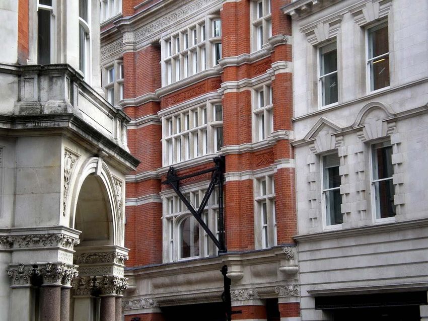
Sturgeon lamp standard, Victoria Embankment

Whitefriars CA Character Summary & Management Strategy SPD Feb 2016   3
Several of the maps in this series on conservation area character are based upon
Ordnance Survey maps © Crown copyright and database rights 2011 Ordnance
Survey 100023243.

Whitefriars CA Character Summary & Management Strategy SPD Feb 2016                4
Contents

Introduction
Character Summary
1. Location and context ....................................................................................................................... 8
Boundary ................................................................................................................................................ 8
2. Designation history ........................................................................................................................... 9
3. Summary of character…………………………………...………………………….............................10
4. Historical development .................................................................................................................. 11
Early history .......................................................................................................................................... 11
Seventeenth and eighteenth centuries ........................................................................................... 12
Nineteenth, twentieth and twenty-first centuries ........................................................................... 14
5. Spatial analysis ............................................................................................................................... 17
Layout and plan form ........................................................................................................................ 17
Building plots........................................................................................................................................ 17
Building heights ................................................................................................................................... 17
Views and vistas .................................................................................................................................. 18
6. Character analysis.......................................................................................................................... 20
Victoria Embankment (W-E) ............................................................................................................ 20
New Bridge Street (S-N) & Bridewell Place .................................................................................... 22
Tudor Street ......................................................................................................................................... 24
North side ............................................................................................................................................ 25
South side ............................................................................................................................................ 26
Temple Avenue .................................................................................................................................. 27
East side ............................................................................................................................................... 27
West side ............................................................................................................................................. 27
Tallis Street ........................................................................................................................................... 28
Carmelite Street ................................................................................................................................. 29
John Carpenter Street ...................................................................................................................... 30
7. Land uses and related activity ...................................................................................................... 31
8. Architectural character ................................................................................................................. 31
Architects, styles and influences ....................................................................................................... 31
Building ages ....................................................................................................................................... 33
9. Local details .................................................................................................................................... 34
Architectural sculpture ....................................................................................................................... 34
Public statuary ..................................................................................................................................... 35
Signage and shopfronts ..................................................................................................................... 35
10. Building materials ......................................................................................................................... 36

Whitefriars CA Character Summary & Management Strategy SPD Feb 2016                                                                                       5

11. Open spaces and trees ............................................................................................................... 37
12. Public realm................................................................................................................................... 37
13. Cultural associations .................................................................................................................... 38

Management Strategy
14. Planning policy ............................................................................................................................. 39
National policy .................................................................................................................................... 39
London-wide policy ............................................................................................................................ 39
City of London Corporation policy ................................................................................................... 39
Protected views .................................................................................................................................. 40
Sustainability and climate change................................................................................................... 41
15. Environmental enhancement ...................................................................................................... 41
16. Transport......................................................................................................................................... 42
17. Management of open spaces and trees ................................................................................... 43
18. Archaeology ................................................................................................................................. 43
19. Enforcement .................................................................................................................................. 44
20. Condition of the conservation area ........................................................................................... 44
Further reading and references
Appendices
Designated heritage assets ............................................................................................................... 48
Contacts ............................................................................................................................................... 51

Whitefriars CA Character Summary & Management Strategy SPD Feb 2016                                                                                      6
Introduction

The present urban form and character of the City of London (the ‘City’) has evolved
over many centuries and reflects numerous influences and interventions: the
character and sense of place is hence unique to that area, contributing at the
same time to the wider character of London.

This character summary and management strategy provides an understanding of
the significance of the conservation area by identifying and analysing its principal
characteristics. It does not include specific detail about every building and feature
within the area, and any omission from the text should not be interpreted as an
indication of lesser significance. The character summary and management strategy
has been prepared in line with the Historic England document Understanding Place:
Conservation Area Designation, Appraisal and Management (2011).

The original character summary was adopted in 1996. This document comprises an
updated character summary and added management strategy. It was adopted as
a Supplementary Planning Document (SPD) to the City of London Corporation’s
Local Plan on 23rd February 2016. It should be read in conjunction with the Local Plan
and other guidance, including Conservation Areas in the City of London, A General
Introduction to their Character (1994) which has more information on the history and
character of the City.

Whitefriars CA Character Summary & Management Strategy SPD Feb 2016                  7
Character summary

1. Location and context

Whitefriars Conservation Area lies between the Temples and New Bridge Street,
fronting the Victoria Embankment. It lies entirely within the Ward of Castle Baynard
and covers an area of 6.4 hectares.

Boundary
Whitefriars’ most conspicuous boundary is the river Thames, drawn along the mid-line
of the river and including the entirety of Blackfriars Bridge. Immediately adjacent to
the bridge (just outside the CA boundary) is a queue of paired piers surviving from
the original railway bridge of 1864, with the second bridge beyond. This ensemble of
infrastructure is an arresting contrast to the more formal urban boundary with the
Temples (see below). The remainder of the eastern boundary is drawn down the
centre of New Bridge Street.

To the north the boundary is less regular, and meets the Fleet Street conservation
area at Bridewell Place. The remainder is drawn around big buildings whose
enlarged modern scale is a dramatic foil to the surviving historic parts of the
streetscape. The western boundary abuts the Inner Temple, within the Temples
conservation area. A leafy, collegiate place, the Temples form a distinct enclave
within the City and the Whitefriars boundary is enhanced by this distinctiveness. It is
an area where proposals for change need to be very carefully considered. There
are no proposals to amend the Conservation Area (CA) boundaries.

Conservation area boundary map

Whitefriars CA Character Summary & Management Strategy SPD Feb 2016                       8
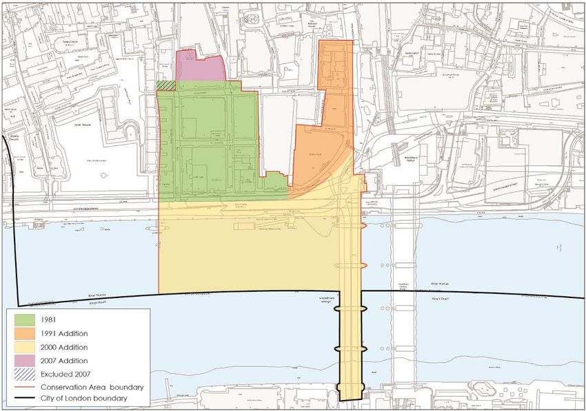
2. Designation history

10 December 1981              Part of the present Whitefriars Conservation Area
                              was designated in December 1981. The street
                              block circumscribed by New Bridge Street,
                              Bridewell Place and Tudor Street was designated
                              as an extension to the Fleet Street Conservation
                              Area in February 1990.

16 May 1991                   Both these areas, together with 19 New Bridge
                              Street (Blackfriars House) and 100 Victoria
                              Embankment (Unilever House), were combined
                              into an extended Whitefriars Conservation Area in
                              May 1991.

28 November 2000              The Conservation Area was extended to include
                              Victoria Embankment, Blackfriars Bridge and
                              approximately half the width of the Thames to the
                              City of London boundary.

14 June 2007                  The boundary was extended behind Northcliffe
                              House to follow the line of Magpie Alley and
                              Ashentree Court.

Whitefriars CA Character Summary & Management Strategy SPD Feb 2016               9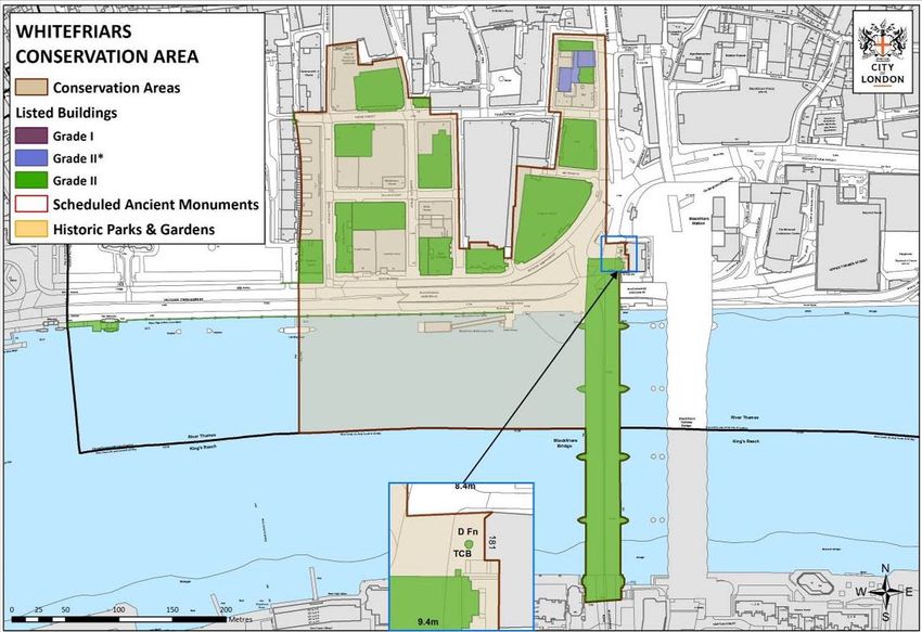
3. Summary of character
The characteristics which contribute to the special interest of Whitefriars
Conservation Area can be summarised as follows:

   •   An array of consistently high-quality late Victorian and Edwardian
       commercial and institutional buildings;

   •   A planned street layout uncommon in the City, set against the more
       evolutionary pattern of adjacent areas;

   •   Highly varied historic land use, including Whitefriars friary precincts, domestic
       tenements, industrial glass and gasworks and corporate headquarters;

   •   Associations with newspaper production, most palpably with the Harmsworth
       empire;

   •   A unique sense of place created by the quiet grandeur of the Victoria
       Embankment and buildings, openness of the Thames and proximity of the
       Temples;

   •   The set-piece created by the transport arteries of the Victoria Embankment,
       New Bridge Street and Blackfriars Bridge;

   •   Foreground to St Paul’s Cathedral and the wider City when viewed from the
       South Bank and other key viewing locations.

Embankment frontages

Whitefriars CA Character Summary & Management Strategy SPD Feb 2016                    10
4. Historical development Early history In early history, much of what is now the Whitefriars conservation area was in the Thames, the land between Tallis street and the Victoria Embankment having gradually been reclaimed from the medieval period onwards. A small number of prehistoric archaeological finds suggest sporadic human activity in the area before the foundation of the Roman city. In the Roman period it lay outside the walled town (founded in the first century AD) and was bordered to the north by Fleet Street, the route running west towards the Strand out of the town’s western Ludgate. The area south of the street may have been a favourable location for later Roman villas; the remains of a building with a tessellated floor, likely a villa, have been found underneath St Bride’s church. Otherwise evidence for Roman occupation is comparatively low, apart from scattered finds of tile and pottery. Occupation of the Roman town ebbed from the fifth century AD and a new settlement, Lundenwic, was established to the west on the Strand. Recent excavations within the Temples immediately west of the conservation area have revealed evidence of glassmaking, trading and burials during the Saxon period. This has been interpreted as an important enclave of activity on the eastern fringes of Lundenwic, suggesting continued activity in the wider area during the Saxon period. Excavations at St Bride’s church have revealed traces of a sixth-century building, possibly an early church. Whitefriars’ location between the old and the new settlements would suggest the area was in use, and it likely had a suburban character with industrial aspects. The conservation area’s name is derived from the Carmelite Friary founded in the 1240s, on land just south of Fleet Street donated by Sir Richard de Grey. Originally a group of lay hermits living on the slopes of Mount Carmel, they were driven to Cyprus, Sicily and England by the Saracen reconquest of the Holy Land. Initially located in remote parts of Northumberland and Kent, they ceased to be hermits after coming to London, becoming more visible in the community and known as Whitefriars after the colour of the mantle worn over their brown robes. Their initial precinct was extended by further southerly land acquisition and reclamation from the Thames in the fourteenth century; a river wall dating from this period was discovered underneath Tallis Street during archaeological work. Today, the friary precincts lie under No. 65 Fleet Street to the north of the conservation area (a fragment of vaulted undercroft can be seen in the basement) and the two blocks immediately to the west across Bouverie Street. Their stairs down to the river edge lay approximately where the junction of Tallis Street and Temple Avenue is now, the Victoria Embankment having reclaimed further land down to the Thames. It was a typical group of friary buildings, including church, cloister and chapter house; their library was said to be particularly notable. After the friary was dissolved in November 1538, the land was sold to individuals who subdivided their plots and developed tenements on them. The pattern and layout of these parcels influenced the subsequent street arrangement, visible on eighteenth century maps. Whitefriars CA Character Summary & Management Strategy SPD Feb 2016 11
Bridewell Palace was built between 1515 and 1520 by Henry VIII, on the western
bank of the Fleet River in what is now the eastern part of the conservation area. It
was linked by a bridge over the Fleet to the Dominican Priory at Blackfriars. A
substantial complex of brick buildings, it was used as a place of reception for visiting
nobles. Holbein’s ‘Ambassadors’ was painted there in 1531. Two years later it was
given to the City by Edward VI for use as a workhouse, known as Bridewell Hospital, a
function it would fulfil until 1855.

‘Agas’ map, c.1570

Seventeenth and eighteenth centuries

Later in the 16th century the inhabitants of the Whitefriars area claimed to be
exempt from the City’s jurisdiction, a claim permitted by Queen Elizabeth I in 1580
and confirmed by James I in a charter of 1608. From about this time the area was
known as ‘Alsatia’ (after the disputed continental territory of Alsace), a sanctuary for
debtors whose criminality and squalor was notorious. These unusual privileges were
repealed in 1697, but the notoriety lingered; what is now Hutton Street just north of
the conservation area was known for years as ‘Wilderness Street’.

Whitefriars had considerable associations with the theatre during the seventeenth
century. The Whitefriars theatre, of uncertain foundation date, operated from the
former friary refectory until 1614. Following this, the Salisbury Court theatre was built in
1629 by Richard Gunnell and William Blagove, hosting plays by Prince Charles’s men
and the Queen’s men until the formal suppression of theatre under the
Commonwealth in 1642. Plays continued to be performed illicitly in the theatre and
its interior was destroyed during a raid by soldiers in 1649. After the Restoration the
theatre was restored and reopened, but was destroyed in the Great Fire and
replaced by the Dorset Garden theatre, also known as the Duke’s theatre, in 1671
on the current site of 60 Victoria Embankment. Sir Christopher Wren is said to have
designed the new theatre, though this attribution is uncertain. It hosted

Whitefriars CA Character Summary & Management Strategy SPD Feb 2016                      12
performances by the Duke’s Company, whose patron was James, Duke of York and
further James II. The theatre was demolished in the early eighteenth century.

The Great Fire completely destroyed the district and, as with much of the City, it was
reconstructed to a similar street and plot configuration. The tenements on the former
friary precincts were rebuilt within a broadly similar arrangement of post-dissolution
land parcels as before. Bridewell was rebuilt to a different plan centred on two
courtyards. Archaeological excavation indicates that the waterfront revetments
were extensively rebuilt after the fire, in some cases with ship timbers.

Horwood’s map, 1799

By the C17 wharves and warehouses had replaced the gardens and orchards that
had previously run down to the waterfront; the Worshipful Company of Carpenters
leased a wharf in Whitefriars in the late 17th century. A notable new enterprise was
the New River Company, established to transport fresh water into London from
Hertfordshire through a conduit, the ‘New River’. The Company began operating
from Whitefriars in 1717, occupying various premises until 1820. The arrival of the New
River coincided with the concealment of the old Fleet, which bordered Whitefriars to
the east. Now known as a ‘ditch’ rather than a river (in reference to its heavily
polluted state), the Fleet was completely covered over in 1764 to form New Bridge
Street, the approach to the new Blackfriars Bridge, designed by Robert Mylne and
opened in 1769. This was a time of general upheaval: further to the east, the old
Ludgate and Roman and medieval city wall were demolished, removing the visible
distinction of Whitefriars as a place outside the original limits of the City. Aside from

Whitefriars CA Character Summary & Management Strategy SPD Feb 2016                   13
this, the remainder of the conservation area retained its seventeenth century street
configuration.
Trade card for Hopton, Hanson & Stafford Glass c.1759
Museum of London
Nineteenth, twentieth and twenty-first centuries
Between 1802 and 1809 James Lewis renewed the east range of Bridewell, from
which the gatehouse survives on New Bridge Street. The prison was closed in
1855, and the other buildings demolished in the 1860s. The establishment of the
City gasworks near Water Lane in 1814 brought heavier industry to the area. In
1834 James Powell purchased the long-established Whitefriars Glass Company,
which may have been the glazier’s workshop recorded on Temple Street in 1789.
The street was renamed Tudor Street in the 19th century and it was from here that
the Company operated until it moved to Wealdstone in 1923. The gasworks
closed in the 1870s.
Around this time the street layout underwent considerable rationalisation, which
produced a regularity that is very unusual within the City’s otherwise evolutionary
street network. This was made feasible by the construction of the Victoria
Embankment between 1864-70 and the widening and extension of routes such as
Tudor Street, removing the slums for which the area had become notorious. At
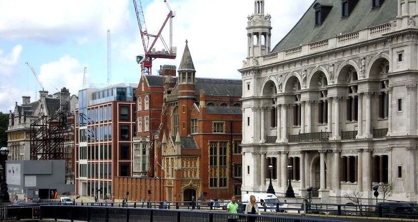
Whitefriars CA Character Summary & Management Strategy SPD Feb 2016 14the same time Blackfriars Bridge was rebuilt, completed in 1869, to designs by Joseph Cubitt and Queen Victoria Street joined it to the heart of the City in 1871. O/S map c.1880 The City Corporation was the main landowner in the area, and these changes realised its plans for a salubrious grid of real estate, far removed from ‘Alsatia’; attracted by the improved, gas-lit streets, businesses and institutions relocated here. In the early 1880s the City of London Boys School was constructed on the site of the former gasworks, with the City of London Girls School and the Guildhall School of Music built to the north in the 1890s. Other institutions, Sion College and the Metropolitan Asylums Board, occupied sites on the embankment facing the river. The remainder of the grid was occupied by the buildings of the newspaper industry, of which a number survive. Fleet Street was synonymous with the newspaper industry. To the south, the newly established grid layout of large plots made Whitefriars a good place for the buildings of newspaper production: large-scale printing works and offices often combined in one building. Examples of these survive throughout the conservation area, such as the Argus Printing Company at the junction of Temple Avenue and Tudor Street, or Northcliffe House where Whitefriars Street meets Tudor Street (on the site of the former glassworks). The area has particular associations with the founders of the Daily Mail, the Harmsworth brothers, Alfred (later Viscount Northcliffe) and Harold (later Viscount Rothermere), who owned and ran newspapers from several businesses in the area. One of their first offices was at 24 Tudor Street in 1893; one of their last was Whitefriars CA Character Summary & Management Strategy SPD Feb 2016 15
Northcliffe House, built next door in 1925-7. With the birth of the Daily Mail and
Daily Mirror and the maturity of the Harmsworth empire, the area was identified
as central to the history of the newspaper industry, while many of the buildings
reflect, in architectural terms, its emerging prestige.

Sweeping the corner of the Embankment and New Bridge Street, Unilever House
was built in the thirties as prestige headquarters for that firm, like J.P. Morgan’s
large building on John Carpenter Street of the late eighties. At this time the
newspaper industry was withdrawing from Whitefriars to the Docklands and
elsewhere; their large, inner-city sites were ideally suited for the large floorplates
required by professional firms following the deregulation of the markets in the
eighties. The schools and other institutions had departed from the area by the
end of the twentieth century. Whitefriars today has a quieter character than its
history might suggest.

More recent developments have generally respected the urban form and scale of
the area as it was established by the late 19th century.

Whitefriars CA Character Summary & Management Strategy SPD Feb 2016                  16
5. Spatial analysis
Layout and plan form
Whitefriars once had the intricate network of medieval streets, lanes and courts
found elsewhere in the City, but a programme of slum clearance, de-industrialisation
and land reclamation significantly changed its topography during the late Victorian
period.

These changes created a formally conceived grid of streets uncommon in the
context of the City. A chief characteristic of Whitefriars is the high permeability and
level of visibility between streets created by the grid. Sequences of buildings follow a
logical progression, with the grandest frontages facing the river with more
understated but equally decorative frontages on the subsidiary streets. There are
clearly legible routes into, within and outside the area.

The flat topography created by reclamation from the Thames provides a local
contrast with the incline and curve of Fleet Street and the routes running south from
it. The openness created by the river and the Embankment is a rarity in the City, as
are the long views of City landmarks and riverfront possible from Blackfriars Bridge.

Building plots
Plots are generally large within the conservation area, with buildings such as Temple
Chambers and Telephone House occupying substantial sites. Some of these large
footprints were created by the newspaper headquarters that were built here during
the boom years of the industry. Carmelite House (frontage to Tallis Street) and
Northcliffe House are surviving examples of this sort of building.

The smaller buildings on Tudor Street reflect or occupy original plots, some with
particular associations with the press. The exception is the one substantial new
development in granite occupying part of two street blocks on Tudor Street. The
block bounded by Bridewell Place and New Bridge Street contain plots of a type
similar to those on Fleet Street, and in other districts of the City.

Building heights
The buildings are principally those of the late Victorian/Edwardian newspaper and
associated industry and have a regular scale, matching the regularity in the street
layout. Occasional smaller buildings such as 2-4 Tudor Street vary this with a more
intimate, human scale.

Robust blocks of architecturally varied, richly modelled and detailed Victorian
and Edwardian buildings attain a cohesive four to five storeys in height. Some
buildings have small turrets or other rooftop elements that add variety to the roofline.
This height is generally matched by more recent developments in the area, creating
a valuable consistency in scale.

The distinctive group of five to six storeys, mostly listed, buildings forming the
complete frontage to Victoria Embankment and New Bridge Street creates a
dignified civic river frontage and introduction to the City.

Whitefriars CA Character Summary & Management Strategy SPD Feb 2016                   17
The townscape effect is one of visual variety and exuberance, achieving both a
pleasing harmony and a strong commercial identity while retaining a human scale.
The conservation area is predominantly within the St Paul’s Heights policy area,
which since the 1930s has regulated the heights of buildings to safeguard views of St
Paul’s Cathedral.

Views and vistas
Whitefriars’ grid of streets enables linear views north/south/east/west along the
compass points between streets. Of particular note are views across the river and
west to the Temples. The river frontage forms a valuable and distinctive part of
the City skyline in views across the r iver, and from a significant distance along the
r iver to east and west. In particular, Blackfriars Bridge offers splendid prospects of
City landmarks, including St Paul’s Cathedral and the City waterfront.

The conservation area lies within the viewing corridors of two London View
Management Framework Protected Views and eight River Prospect Views. The
majority of the area is covered by the St Paul’s Heights policy area, and parts of it fall
within the Monument Views policy area. See the ‘Protected Views’ section of the
Management Strategy for more information.

The following illustrates the range of distant and local views which exist in the
Whitefriars Conservation Area. This list is not comprehensive, and the area provides
further opportunities to capture long, short and kinetic views.

Whitefriars CA Character Summary & Management Strategy SPD Feb 2016                    18
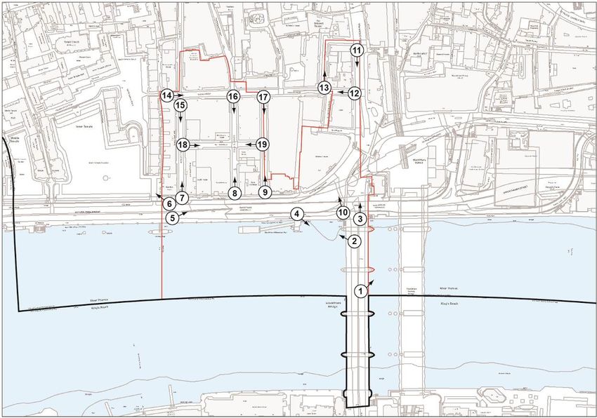
1. View of St Paul’s Cathedral from Blackfriars Bridge
   2. View of the Victoria Embankment from Blackfriars Bridge
   3. View towards New Bridge Street from Blackfriars Bridge
   4. View of Blackfriars Bridge from the Embankment
   5. View of Embankment frontages from opposite Hamilton House
   6. View into the Temple gardens from opposite Hamilton House
   7. View north up Temple Avenue from the Embankment
   8. View north up Carmelite Street from the Embankment
   9. View north up John Carpenter Street from the Embankment
   10. View of Unilever House from the northern end of Blackfriars Bridge
   11. View towards Blackfriars Bridge from No. 13 New Bridge Street
   12. View west along Tudor Street from New Bridge Street
   13. View north up Bridewell Place from Tudor Street
   14. View east along Tudor Street from the boundary with the Temples
   15. View south down Temple Avenue towards the Embankment
   16. View south down Carmelite Street towards the Embankment
   17. View south down John Carpenter Street towards the Embankment
   18. View east along Tallis Street from Temple Chambers
   19. View west along Tallis Street from John Carpenter Street

Additionally, noteworthy views of the conservation area are possible from Waterloo
Bridge and the South Bank.

Whitefriars CA Character Summary & Management Strategy SPD Feb 2016              19
6. Character analysis
Victoria Embankment (W-E)

Hamilton House                      Former Sion College & City of London School

Victoria Embankment was completed in 1870 to a plan by Sir Joseph Bazalgette,
straightening the previously irregular waterfront with a broad new carriageway. A
few years later the grid of streets was developed immediately to the north. The
broadness of the Embankment is accented by the adjacent Thames, together
creating a valuable sense of openness rare in the City. The narrow, more urban
views north along Temple Avenue, Carmelite Street and John Carpenter Street
offer juxtaposition with this open quality. Trees are planted towards the western
part, providing a welcome green enclave with the nearby Temple gardens.
Along the waterfront there are sculptural features of interest: regularly spaced
iron sturgeon lampstands ornamented with marine motifs and lions head mooring
rings on the river wall.

The ornate, richly detailed, late 19th century buildings facing the Thames give the
Embankment a sense of quiet grandeur. Hamilton House (by Sir William Emerson)
has a stately Portland stone frontage in a Renaissance style with a contrasting
band of sandstone at the upper levels. This is set back from the street behind a
row of decorated stone piers and railings enclosing a small garden. Opposite, the
Baroque Embankment elevation of Telephone House (No. 40, see Temple
Avenue) is similarly recessed behind a garden and railings, and both buildings
have prominent gables at roof level. The shared materials but subtle stylistic
variations give depth to the street scene.

Audit House (No. 58) was formerly the Employment Appeal Tribunal. It has a more
understated red brick elevation with stone dressings and projecting end bays
with classical details. The varying use of Portland stone and red brick as the
dominant building materials are an important hallmark of the conservation area.
At the time of writing, the building is undergoing redevelopment behind the
retained Embankment façade. Carmelite House (No. 50) is a less successful
recent development that would have profited from further depth and modelling
to its elevations. The boldly contemporary approach is too abrupt a statement
within the sequence of generously detailed historic frontages.

Whitefriars CA Character Summary & Management Strategy SPD Feb 2016             20
No. 9 Carmelite Street housed the former Thames Conservancy Offices. The red
brick with Gothic details complement the neighbouring former Sion College (No.
56, by Sir Arthur Blomfield), which has an elaborately detailed Gothic revival
frontage. Both buildings provide a welcome contrast with the simplicity of
Carmelite House. Of red brick with stone detailing, No. 56 has a profusion of oriel
windows, buttresses, turrets, pinnacles and window tracery that create a wealth
of visual interest and evoke the building’s former use as an ecclesiastical college.
A later brick screen punctuated with slim traceried openings creates regularity at
street level. The collegiate effect is complemented by the institutional
architecture of the former City of London School (No. 60). Built in 1880-82 to
designs by Davis & Emmanuel, it has an elaborate Portland stone frontage with
pink granite columns, classical detailing and prominent sculpture of famous
figures and disciplines. It has a striking, steeply pitched roof with octagonal
lantern and corner turrets, and completes the run of buildings in an appropriately
ornate manner.

After the Temples, the Victoria Embankment frontages have an important role as
an introduction to the City when approached along the Thames from the west.
This area will be significantly altered by the forthcoming Thames Tideway Tunnel
works, which propose the construction of a new pier and public space alongside
the Embankment. Furthermore, the proposed Cycle Superhighway will have a
visual impact on the Blackfriars Bridge and New Bridge Street (below).

      Retained façade of Audit House       Blackfriars Bridge lamp standard

Blackfriars Bridge was erected in 1869 to designs by James Cubitt, replacing the
previous bridge by Robert Mylne. It spans the Thames with five shallow, segmental
arches of cast iron springing from granite abutments. These are capped with
squat columns supporting pedestrian niches linked by a decorative iron
balustrade. Along the centre run slender original lamp standards, valuable
survivals of their kind. The bridge’s restrained gothic detailing complements the
adjacent 19th century frontages on the Embankment, with which it forms a set-
piece commemorating the era of Victorian public improvement works. The
bridge is named from the Blackfriars friary that was located on the eastern bank
of the river Fleet.

Whitefriars CA Character Summary & Management Strategy SPD Feb 2016               21
Blackfriars Bridge
Moored opposite Hamilton House is HMS President, a former Royal Navy sloop
built in 1917 by Lobnitz & Co Ltd for convoy escort duty. Located at this mooring
on the Victoria Embankment since 1922, she was used as a Royal Navy Reserve
training ship until 1989. She was originally named HMS Saxifrage, a genus of plants
that includes London Pride, underlining her long connection with the city. HMS
President is included on the National Register of Historic Vessels administered by
National Historic Ships UK. Facing the dignified frontages of Hamilton and
Telephone House, the boat further augments the historicity of this part of the
conservation area. The vessel will be temporarily moored elsewhere for the
duration of the aforementioned Thames Tideway Tunnel works at Blackfriars.
New Bridge Street (S-N) & Bridewell Place
14 &19 New Bridge Street
Laid out in 1764, New Bridge Street was created as an approach to the first
Blackfriars Bridge (designed by Robert Mylne) and covered over the Fleet River,
Whitefriars CA Character Summary & Management Strategy SPD Feb 2016 22the line of which it follows. The bridge approach has been intensively developed: originally a small square named Chatham Place, it was reconstructed after the building of the current bridge, altered for the creation of Queen Victoria Street and again to its present form in 1963 for the Blackfriars Underpass. A statue of Queen Victoria commemorates the 19th century work, while on the eastern side of New Bridge Street a K2 telephone kiosk and temperance drinking fountain are street furniture of further interest. The buildings on the street are generally larger than those on the Embankment, and are set back from the street behind iron railings. Addressing the road, the bridge and the river is Unilever House, built in 1930-2 to designs by J. Lomax Simpson with Burnet, Tait & Partners. The building is a grand classical composition in Portland stone whose curve acts as a monumental pivot between New Bridge Street and the Embankment. A row of giant Ionic columns gives the façade rhythm and verticality, and the scale of the building is offset by its modelling and detailing, particularly to the recessed upper storeys. Flanking equestrian sculpture adds further interest. It has been called the largest of the ‘prestige headquarters’ built for large City firms between the wars. Along with the Faraday Building nearby, this ‘lofty edifice’ instigated the development of the St Paul’s Heights policy, designed to control development around the Cathedral to preserve views of its setting. No. 19 (formerly Blackfriars House, built 1913-17 and now a hotel) has a similarly large scale but with a subtler, stripped classical treatment executed in white glazed faience, an unusual treatment in the City. Well-modelled facades alleviate its large scale. The building is recessed behind railings and ironwork arches that add interest to the street scene, complemented by decorative iron balconies at first floor. No. 16-18 was built in 1903-5 as the headquarters of the London Missionary Society (commemorated by a plaque). Here, the large scale of the previous buildings is repeated in a stone Baroque composition, with detailing echoing that of Telephone House (see above). No. 15 begins a sequence of more compact buildings along the street whose lower scale is an effective prelude to the larger buildings previously described. The group is united by shared motifs and verticality of pilasters. No. 15 has an understated stone frontage with 18th century detailing and ornamental balconies at first floor level, its subtlety providing a favourable contrast with the larger buildings. No. 14 is the former gatehouse of Bridewell Hospital (James Lewis, 1802-8), with a fine stone classical frontage behind iron railings. No. 13 is constructed in brick with stucco dressings in an eclectic style, with French and Classical motifs reminiscent of the Victorian commercial architecture of Ludgate Circus. Its frontage turns onto Bridewell Place, a dog-leg named after the former palace and hospital on this site. No. 9 has brown brick upper storeys over an open stone colonnade, traditional materials sympathetic to the context of the conservation area, though its upper storeys are of an incongruous height. This elevation to Bridewell Place forms the rear setting of the buildings on New Bridge Street and could be enhanced. Whitefriars CA Character Summary & Management Strategy SPD Feb 2016 23
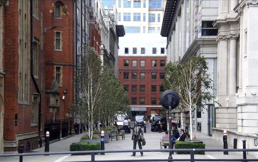
Tudor Street

Tudor Street, looking east towards New Bridge Street

Tudor Street was formed by extending King Tudor Street (established by the 17th
century) westwards from New Bridge Street towards the Inner Temple in the 19th
century. It forms the northern edge of the street grid laid out by the City of
London Corporation in the 1880s. There is an important contrast between the
commercial bustle of New Bridge Street at the eastern end and the relative
serenity of the Temples, glimpsed through an archway at its western end.

Whitefriars CA Character Summary & Management Strategy SPD Feb 2016           24
North side

 No. 2-3                     Northcliffe House          No. 24

After the flank elevations of No. 16-18 and No. 19 New Bridge Street, No. 2-4 is the
former Institute of Journalists, constructed between 1902-4 in a Queen Anne style.
It has a pleasing modesty that is derived from its low scale, traditional roof form
and simple Classical details. Other surviving newspaper buildings in the
conservation area share the red brick and stone idiom. On a similarly modest
scale, No. 24 is an early 19th century detached house with later shops, the pale
stucco and crisp detailing of which compare well with surrounding buildings of
different styles. It has a domestic character uncommon in the conservation area,
an important survival of the period before the streets were laid out in their current
form.

Northcliffe House (No. 26) is the former combined offices and printing workshops
of Associated Newspapers, a function indicated by large expanses of glazing on
the elevations (to allow the maximum amount of light for typesetting and
compositing). The building occupies the former site of the Whitefriars Glassworks.
Steel framed and clad in stone, it is an important example of the design solutions
achieved in housing the different elements of newspaper production on the
same site (for example, it was the first British newspaper printing office to have
reel fed from beneath the printing presses). It was built in 1925-5 to designs by Ellis
and Clarke, and has an understated Classical/neo-Egyptian character found
elsewhere at the former Daily Telegraph building on Fleet Street. The elevations to
Tudor Street and Whitefriars Street are finely detailed and modelled, while the
octagonal turret adds interest to the roofline.

No. 28 is the former White Swan Tavern, which shares the height and Classical
motifs of Northcliffe House but expresses them differently. The street elevation is of
brick with slender stone pilasters and other ornaments, a mixture echoed at No.
2-4 and characteristic of the conservation area. At the junction of Tudor Street
and Bouverie Street (east side) is a contemporary stone and glass building that
presents a long brick and stone elevation to Bouverie Street. It has recessed
upper storeys that are sympathetic to the scale of the conservation area.

Whitefriars CA Character Summary & Management Strategy SPD Feb 2016                 25
South side

 No. 25                                   Gateway to the Temples

With its neighbour No. 3-5, No. 15-17 has a large granite elevation with irregular
window openings and classical accents cast in a modern style. The building’s
forceful bulk clashes with its surroundings to some extent, but its bold post-
modernity has historic value. No. 21 is a modern development that gives a
contemporary treatment to traditional materials. Circular stone columns divide
the bays, which contain projecting rectangular windows clad in orange tiles and
linked by thin metal bars. The façade has a similar rhythm to that of Northcliffe
House opposite but is less forceful, with a weightless quality imparted by its
materials. The block bounded by Tudor Street, Temple Avenue, Tallis Street and
Carmelite Street is part of this development, which skilfully incorporated the
frontages of many historic buildings.

No. 25 is the former premises of the Argus Printing Company. Of stone and red
brick with Ruabon terracotta dressings, it is a muscular building enhanced by the
wealth of detail on both facades. The ground floor has keystones featuring
grotesque heads, while the corner holds a carving of the company’s insignia.
Higher up, bands of delicate terracotta detail are woven underneath stone
mullion and transom windows. This assemblage of materials, motifs and upper
level detailing creates a highly individual character. Loading bays at the end of
the Temple Avenue elevation give an indication of the original design as printing
works. It forms a group with Northcliffe House and the former White Horse Tavern
enhancing the conservation area.

Whitefriars CA Character Summary & Management Strategy SPD Feb 2016             26
Temple Avenue
Temple Chambers (detail) Telephone House (detail)
Part of the grid of streets laid out by the City Corporation in the 1880s, Temple
Avenue is one of three streets that connect Tudor Street with the Victoria
Embankment (the others are Carmelite Street and John Carpenter Street). Views
south down these streets offer prospects of the river framed by the ornate
architecture of the river frontages, while views north from the river into the urban
realm are an effective foil to the openness of the Embankment and Thames. Both
sets of views are key elements of the character of the conservation area.
East side
Temple House (No. 6) has a red brick and stone façade with Classical detailing
and projecting oriel windows, some of which contain stained glass. These give a
strong sense of rhythm to both frontages (the other on Tallis Street), further
enhanced by the arched openings at ground floor. A small clock tower crowned
with a pediment adds interest at roof level, while at ground level iron railings to
the street create a neatness shared by nearby buildings.
The main frontage of Telephone House (No. 2-4) is a monumental contrast with
the previous building. The stately twenty-one bay elevation is designed in a
Baroque style and executed in stone with rich modelling and ornamentation,
particularly at the upper levels. It was built as the London headquarters of the
National Telephone Company, a wealthy organisation that amalgamated early
provincial telephone networks into a national system. These origins remain
evident in the first floor sculptures of cherubs grasping early telephone handsets.
West side
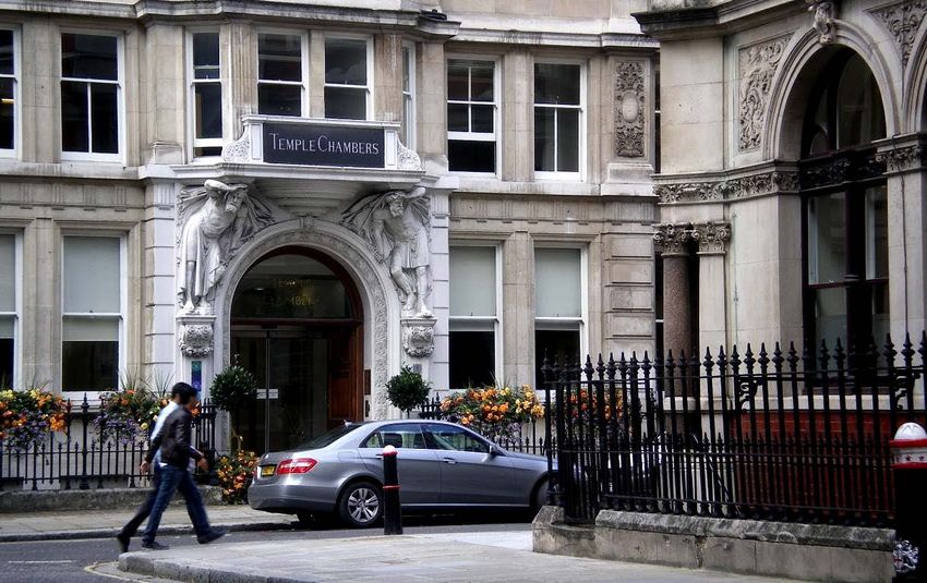
Practically all of the west side of Temple Avenue is occupied by Temple
Chambers (No. 3-7), a range of purpose-built legal chambers completed in 1887.
Whitefriars CA Character Summary & Management Strategy SPD Feb 2016 27The stone frontage has understated Jacobean and Classical accents and contains many projecting and recessed sections providing rhythm to the long frontage. The central bay has a carved stone doorcase with sculpture, detailing and lettering. The whole elevation is recessed from the street behind an intact run of decorative iron railings. Their traditional roof forms and chimney stacks survive, which are instrumental in providing a sympathetic setting to the neighbouring Inner Temple. With the other buildings on Temple Avenue the overall effect is one of orderly sophistication. Tallis Street Former Guildhall School of Music No. 2 & Carmelite House Tallis Street is named after the 16th century English composer, Thomas Tallis, whose name is among those inscribed on the former Guildhall School of Music (No.1). It forms an intersection between the three north-south streets, and partially marks the line of the old waterfront before its extension to form the Embankment. The former Guildhall School of Music was constructed between 1885-7 to a Neo- classical design by Sir Horace Jones, Surveyor to the City of London, who was responsible for notable City buildings such as Tower Bridge and Leadenhall Market. The building has predominantly classical details executed in stone, with inscriptions located between decorated terracotta panels and a row of elliptical windows on the upper levels. The return elevations to Carmelite Street and John Carpenter Street are slightly plainer, except for a northern extension of 1897-8 that is taller and more ornamented with the names of composers inscribed upon it. Opposite on Tallis Street, Tallis House (No. 2, by Royce, Hurley and Stewart) provides a modern interpretation of themes within in the conservation area, with the red brick, banded stone and projecting oriel windows recalling Temple House (see above). Though these contextual aspects of the design are praiseworthy, the building ultimately falls short of the refinement characteristic of other buildings in the conservation area. Whitefriars House (No. 6) was formerly the premises of the National Press Agency. Of red brick detailed with café-au-lait terracotta, it has a well-proportioned mixture of bow windows, understated classical elements and applied arcading. Whitefriars CA Character Summary & Management Strategy SPD Feb 2016 28
The corner bay successfully addresses the junction of Tallis Street and Carmelite
Street with a terracotta doorcase, oriel window and archway.

Continuing the newspaper derivation, Carmelite House (Tallis Street and
Carmelite Street elevations) was designed by H.O. Ellis for Lord Northcliffe’s
Associated Newspapers in a monumental neo-Tudor style. Built between 1897-9, it
is the oldest survivor of the combined newspaper factories and offices that once
proliferated in the area. Surviving iron cranes and the large expanses of glazing
attest to this former function (and make an instructive comparison with Northcliffe
House on Tudor Street). The rich modelling and alternating bands of stonework
and brickwork echo themes elsewhere in the conservation area. As an expression
of corporate power, the building complements Telephone House (see above),
which it adjoins.

Carmelite Street

  North-east side                                 Former Whitefriars Fire Station

The elevations on Carmelite Street are predominantly the flanks of other buildings
described on Tudor Street, Tallis Street and the Victoria Embankment. They are a
blend of stonework, brick and stone/terracotta dressings typical of the
conservation area. The street is named from the Carmelite Friary (Whitefriars) that
existed immediately to the north of the conservation area.

On the west side, the façade of the former Wheatsheaf House (formerly No. 4)
survives incorporated into a later development. A former warehouse, it has red
brick piers with stone detailing carried on an arcade of six columns with yellow
brick detailing. A small Italianate turret adds interest at roof level.

No. 7 was the Whitefriars Fire Station, formerly the main fire station of the City
division. Constructed between 1896-7 to designs by the L.C.C Architects’
Department, it has simple neo-Tudor detailing and a prominent gable that sits
well alongside the former Sion College (see above). Three openings capped by
Tudor arches at ground level, now blocked, indicate the exit and entry points for

Whitefriars CA Character Summary & Management Strategy SPD Feb 2016                 29
horse-drawn fire engines. It has a lacklustre modern elevation to John Carpenter
Street.

John Carpenter Street

John Carpenter was a Town Clerk of the City of London who in the 15th century
left a bequest enabling the foundation of the City of London School, which
occupied a site on the Embankment at the end of the street. Most of the street
contains the flank elevations of buildings described above. The southern end of
the street is pedestrianised, an attractive space framed by planting, benches,
sculpture and the flank elevations of the former City of London School and
former Sion College.

John Carpenter Street from the Embankment

Whitefriars CA Character Summary & Management Strategy SPD Feb 2016            30
7. Land uses and related activity

The p r e s e n t uses a r e principally office, with dispersed secondary catering,
hotel and retail uses. The diversity of activity and associated vitality has been
diluted by the relocation of the schools and the recent dispersal of the press,
printing and publishing industries. There are some buildings in residential use, but
these account for a low proportion overall.

The Thames remains a working river, as it has been for over two thousand years. In
the transportation of passengers and freight it has a vitality that contributes to the
character of the conservation area. It has played a vital logistical role in a
number of riverside developments such as Blackfriars Station. Furthermore, it has a
potential role to play in relieving vehicular congestion within central London.

8. Architectural character
Architects, styles and influences

Whitefriars’ comprehensive redevelopment in the latter decades of the 19th century
created an overall harmony in architectural character, marked by subtle gradations
in style, scale and materials. As intended, it attracted relatively prestigious businesses
and institutions with the resources for opulent buildings, transforming this riverfront
area from a place of industry to one of architectural expression. The City
Corporation had some stylistic influence: the former Thames Conservancy Offices
(No. 9 Carmelite Street with an Embankment frontage) are said to have been
constructed in a Gothic style to match neighbouring Sion College at the
Corporation’s behest.

Former Thames Conservancy Offices (later) & former Sion College (earlier)

Generally, the calibre of architects working in Whitefriars was high. Sir Horace Jones
was responsible for many City buildings that are now acclaimed landmarks (such as
Tower Bridge), and the Guildhall School of Music was one of his last works. Sir Arthur
Blomfield (Sion College) was an important and prolific exponent of the Gothic
revival, while Sir William Emerson (Hamilton House) designed a number of high-profile
buildings in India, then part of the British Empire. Sir Joseph Bazalgette, the engineer

Whitefriars CA Character Summary & Management Strategy SPD Feb 2016                    31
responsible for the Victoria Embankment, is well known for designing London’s sewer
system.

Other architects were locally prolific: James Lewis (No. 14 New Bridge Street) was
surveyor to Christ’s and Bethlem Hospitals in addition to Bridewell, while Ellis and
Clarke (Northcliffe House) worked with Sir Owen Williams on the Daily Express building
in Fleet Street. John Whichcord Junior (Temple Chambers) built numerous offices in
the City, including the former National Safe Deposit at No. 1 Queen Victoria Street
(now the City of London Magistrates’ Court). Thomas Tait designed Unilever House
with James Lomax-Simpson, and was partly responsible for the Daily Telegraph
building on Fleet Street.

Blackfriars Bridge was designed by Joseph Cubitt and the original neighbouring
railway bridge of 1862-4 (of which only the piers remain) was also his design. Beyond,
the second Blackfriars Railway Bridge of 1886 (originally St Paul’s Railway Bridge) was
designed by John Wolfe-Barry and Henry Marc Brunel.

Whitefriars exhibits the eclectic variety and bombast typical of late
Victorian/Edwardian commercial architecture. Corporate exuberance can be seen
at Telephone House (Baroque), Unilever House (Classical), Northcliffe House
(Classical/neo-Egyptian) and Carmelite House (Tallis Street elevation, neo-Tudor).
While these buildings are largely of one style, others are more eclectic, mingling
Classical, Tudor, Queen Anne or Jacobean devices, such as at No. 25 Tudor Street,
neighbouring No. 6 Temple Avenue or No. 13 Bridewell Place. The former City of
London School combines varying motifs within an overarching Northern Renaissance
style.

 Temple Chambers, Temple Avenue

A more understated architecture is offered by Temple Chambers, an effective
segue into the Temples across the border of the conservation area. Further variety is

Whitefriars CA Character Summary & Management Strategy SPD Feb 2016                 32
found in the Georgian domesticity of No. 24 Tudor Street and the 20th century
faience cladding of No. 19 New Bridge Street. Blackfriars Bridge is an example of
engineering functionality enlivened with Gothic detailing that complements that at
Sion College.

While the range of styles and motifs listed above appears broad, the buildings’ close
date range, small material palette and quality of execution results in an overall
consistency of scale and appearance that is to the linchpin of the conservation
area’s character.

Building ages

The buildings in Whitefriars all date from the 19th, 20th and 21st centuries. Earliest
among them are the former Bridewell Gatehouse (No. 14 New Bridge Street) and
No. 24 Tudor Street, both dating from the early 19th century. One of the catalysts for
Whitefriars’ redevelopment was the completion of the Victoria Embankment in 1870,
following which the grid of streets and buildings were laid out, commencing with the
City of London School in 1880-82. Buildings on the southern end of New Bridge Street
are either early 20th century or interwar. There are some postwar and early 21st
century buildings, but these account for a low proportion overall. More recent
developments have regularly incorporated the retained facades of earlier buildings.

Whitefriars CA Character Summary & Management Strategy SPD Feb 2016                33
You can also read