North East Link Project - Ecology Impact Assessment Templestowe Road Soccer Facilities (27-59 Templestowe Road, Bulleen) Prepared for North East ...
←
→
Page content transcription
If your browser does not render page correctly, please read the page content below
se

         North East Link Project
            Ecology Impact Assessment
     Templestowe Road Soccer Facilities
     (27-59 Templestowe Road, Bulleen)
                      Prepared for North East Link

                                         July 2020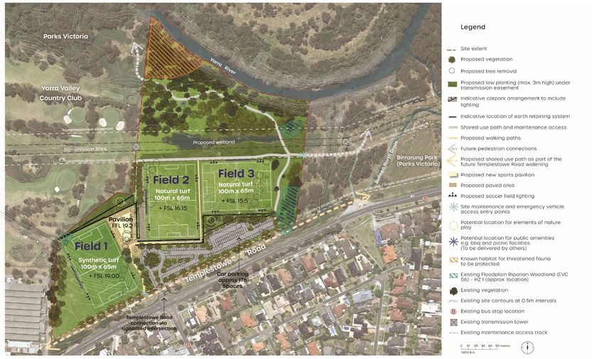
Executive Summary
The North East Link has undergone an extensive and robust planning and environmental
assessment process, including:
An Environment Effects Statement (EES), which included proposed Environmental
Performance Requirements (EPRs) to avoid, manage and mitigate identified risks.
A Planning Scheme Amendment (PSA) to facilitate the use and development of the
Project.
A Works Approval Application (WAA) for the installation of the road tunnel ventilation
system.
Additional approval documents including a Public Environment Report (PER) for works
involving matters of national environmental significance (MNES).
This Ecology Impact Assessment has been prepared to inform the North East Link Project’s
(NELP) draft Planning Scheme Amendment (PSA) C132mann, which seeks to facilitate the
proposed Templestowe Road Soccer Facilities (the Project). The relocation of impacted sport
and recreation facilities is required as a consequence of their displacement by the construction
of North East Link. It is proposed to relocate the existing Bulleen Park Soccer Fields to a new
Site at 27 - 59 Templestowe Road, Bulleen. The relocation Site includes two properties (the
Bulleen Golf Driving Range at 37-59 Templestowe Road and adjacent Parks Victoria public land
at 27-33 Templestowe Road) in Bulleen, collectively described as 27-59 Templestowe Road
(The Site).
This report provides the results of flora and fauna assessments of the Site and discusses the
relevant legislation and approvals associated with development of the Site. The report findings
are presented in two parts:
1. Existing conditions at the Site – flora and fauna
2. Planning and environmental approval implications of the Project – as related to flora and
fauna
The purpose of this report is to assess the potential ecological impacts associated with the
redevelopment of the Site.
Existing conditions
Flora
The Site occurs within a broad urban setting that has been largely cleared of indigenous native
vegetation. Four primary vegetation types occur on Site.
1. Introduced grassland. The majority of the Site supports mown or periodically slashed
introduced grassland. Native species are absent from this vegetation type.
2. Planted vegetation. Much of the woody (treed) vegetation that is present has been
planted for amenity purposes, and comprises a range of locally indigenous native trees,
non-indigenous native trees, and introduced species.
3. Native vegetation patches. Three small patches of native vegetation comprising
Floodplain Riparian Woodland (EVC 56) occur within the Site. All patches appear to have
colonised previously cleared areas in recent decades.
GHD | Report for North East Link Project – Ecology Impact Assesment | i
4. Scattered native trees. A number of scattered native trees (both large and small) occur
within the broader matrix of introduced grassland vegetation.
Fauna
The Site abuts the Yarra River and therefore is within an area of relatively high ecological value.
Forests and woodlands along the Yarra River attract and support a range of common,
uncommon and rare fauna, including threatened species, and provide a wildlife corridor for
fauna, linking otherwise isolated areas of habitat. The riparian habitat along this section of the
Yarra River supports the Powerful Owl (Ninox strenua), which is listed as threatened under the
Victorian Flora and Fauna Guarantee Act 1988 (FFG Act) and is reported to nest in the area
regularly.
Away from the river, the scattered tree habitat within this Site is typical of golf courses, and
provides more fragmented habitat of varying value, depending on the size and condition of the
trees or tree patches and connectivity to other patches. While mowed grassy areas with
scattered trees tend to be of lower value to native fauna, all non-developed green space in this
area contributes to the value of the corridor and habitat for fauna. All trees within the Yarra River
floodplain in the area provide important foraging habitat for Powerful Owls.
Impact assessment
Flora
The construction footprint would result in the loss of:
0.015 ha of native vegetation (Floodplain Riparian Woodland, EVC 56)
6 Small Scattered Trees
No species or communities listed under the EPBC or FFG Acts would be impacted by the
proposed works. No flora listed as protected were identified and a permit under the FFG Act
would not be required.
Offsets for the proposed impacts would be accounted for under the PSA for the North East Link
Project.
Fauna
Potential impacts on fauna associated with the construction phase of the Project include:
Clearing of vegetation during construction resulting in the loss or degradation of habitat
supporting threatened or non-threatened fauna
Clearing of vegetation during construction resulting in reduced viability of non-threatened
native fauna populations
Construction activities resulting in erosion/sedimentation, litter or release of contaminants
into wetlands and waterways leading to degradation of fauna habitat
Introduction or spread of weeds, pest species, or pathogens that degrade habitat for
fauna
Death or injury of native fauna
Construction noise and/or lighting resulting in disturbance of threatened or non-
threatened fauna
Habitat fragmentation resulting in reduced effectiveness of terrestrial wildlife corridors and
creation of barriers to fauna movement
GHD | Report for North East Link Project – Ecology Impact Assesment | ii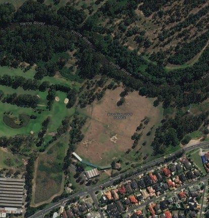
Potential impacts on fauna associated with the operation phase of the Project include:
Operational noise and/or lighting resulting in elevated disturbance to threatened or non-
threatened fauna
Planning and environmental approval considerations
Table 1 below summarises the on-site findings within the Site with respect to relevant
environmental legislation and policy that would be relevant based on the current proposed
design.
Table 1 Summary of flora and fauna assessment results in relation to key
approval requirements for Templestowe Road Soccer Facilities
Legislation / Policy Relevant on-Site finding Permit requirement Recommendation
Commonwealth No EPBC-listed flora species or No MNES are considered No further action required
Environment ecological communities are likely to be significantly
Protection and present in the Site, nor are they impacted by the Project.
Biodiversity expected to occur due to the
Conservation Act highly modified nature of the Site.
1999 (EPBC Act)
The Grey-headed Flying-fox
(Vulnerable) is likely to forage
frequently within the Site. Small
numbers of other threatened
fauna (e.g., Swift Parrot; Critically
Endangered) may visit the Site
occasionally or rarely. No species
listed as threatened or migratory
under the EPBC Act is expected
to be impacted significantly by the
Project design.
Environment Effects Under the EE Act, projects that Unlikely to trigger No further action required
Act 1978 (EE Act) could have a ‘significant effect’ on ecological requirements for
Victoria’s environment can require an EES.
an Environment Effects Statement
(EES) to be prepared and
assessed.
The EES referral criteria for
impacts to ecological values (DSE
2006) were considered as part of
this assessment to determine
whether or not an EES is likely to
be required.
Flora and Fauna No flora or communities listed as No permit required to Flora – N/A
Guarantee Act 1988 threatened under the FFG Act remove protected flora
(FFG Act) were recorded, nor are they under the FFG Act. Fauna – Minimising the
expected to occur due to the removal of trees and
No permit is required with shrubs, and minimising
highly modified nature of the Site.
respect to fauna. However, noise and light pollution
No flora listed as protected under the Project will need to will reduce the likelihood
the FFG Act were recorded. satisfy DELWP that impacts of project impacts on
on FFG listed fauna fauna.
At least one species of fauna (including the Powerful
listed as threatened under the Owl) have been minimised
FFG Act is likely to use (and or avoided.
possibly nest in) the treed habitats
within and around the Site
(Powerful Owl Ninox strenua).
Removal of trees and shrubs, and
noise and light pollution have a
real chance of impacting on this
species and should be avoided.
GHD | Report for North East Link Project – Ecology Impact Assesment | iii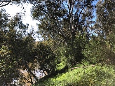
Legislation / Policy   Relevant on-Site finding              Permit requirement               Recommendation

Planning and           Native vegetation was identified      Any proposed impacts to          Requirements under the
Environment Act 1987   within the Site. Much of the native   remnant native vegetation        P & E Act will be met
(P&E Act)              vegetation present in the Site has    or vegetation planted for        under the PSA.
                       been planted for amenity and          conservation purposes will
                       does not require a permit to          require a permit under the
                       remove. However, one patch of         P&E Act, and offsets will
                       native vegetation, as well as six     be required.
                       scattered native trees are
                       proposed to be removed.               Permit to remove native
                                                             vegetation (patches of
                                                             vegetation and scattered
                                                             native flora) required.

Guidelines for the     The location mapping identifies       Planning permit and offsets      Requirements under the
removal, destruction   that the Site is classified as        required under P&E Act.          P & E Act will be met
or lopping of native   Location 2.                                                            under the PSA.
vegetation (DELWP                                            A permit application will
2017) – the            Based on the design option for        need to be referred to
Guidelines.            this Site, 0.186 ha of native         Manningham City Council.
                       vegetation will be removed
                       (inclusive of scattered trees).
                       Consequently, the Project needs
                       to be assessed via the
                       ‘Intermediate’ assessment
                       pathway.

Catchment and Land     Declared Noxious Weeds                No permit required.              NELP must comply with
Protection Act 1994    (Restricted and Regionally                                             requirements to limit the
(CaLP Act)             Controlled within the Port Phillip                                     spread of declared
                       and Westernport CMA) were                                              noxious weeds within and
                       recorded within the Site during the                                    off site, via vehicle
                       field assessment.                                                      hygiene procedures listed
                                                                                              in an Environmental
                       The Project has the potential to                                       Management Plan (EMP).
                       spread and/or introduce weeds
                       during proposed works.

Wildlife Act 1975      Some of the larger trees within the   A Management                     If large trees require
                       Site, particularly along the Yarra    Authorisation (a permit          removal (or limb lopping),
                       River, may have hollows and may       under the Wildlife Act 1975)     then a Management
                       house arboreal fauna such as          would be required for the        Authorisation should be
                       possums or nesting birds.             purposes of capturing,           obtained so that an
                                                             handling or relocating           ecologist can be present
                                                             fauna, and will be required      during works to help
                                                             if any tree/limb removal is      fauna to safety, as
                                                             proposed.                        required.

                                             GHD | Report for North East Link Project – Ecology Impact Assesment | iv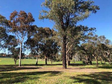
Table of contents
  Executive Summary .................................................................................................................................. i
           Existing conditions .......................................................................................................................... i
           Impact assessment ........................................................................................................................ ii
           Planning and environmental approval considerations .................................................................. iii

  Abbreviations .......................................................................................................................................... vii

  1.       Introduction..................................................................................................................................... 1
           1.1       Project background .............................................................................................................. 1
           1.2       Purpose of this report........................................................................................................... 1

  2.       Relevant Legislation, Policy and Guidelines .................................................................................. 2
           2.1       Commonwealth legislation ................................................................................................... 2
           2.2       State legislation .................................................................................................................... 2
           2.3       State policy and guidelines .................................................................................................. 2

  3.       Methods.......................................................................................................................................... 3
           3.1       Site and study area .............................................................................................................. 3
           3.2       Existing conditions assessment ........................................................................................... 3
           3.3       Impact assessment .............................................................................................................. 4
           3.4       Nomenclature ....................................................................................................................... 5
           3.5       Assumptions and limitations ................................................................................................ 6

  4.       Project description .......................................................................................................................... 8

  5.       Existing conditions ....................................................................................................................... 10
           5.1       Site description .................................................................................................................. 10
           5.2       Existing conditions – Flora ................................................................................................. 10
           5.3       Existing conditions – Fauna ............................................................................................... 19

  6.       Impact assessment ...................................................................................................................... 22
           6.1       Impact Assessment - Flora ................................................................................................ 22
           6.2       Impact Assessment - Fauna .............................................................................................. 25

  7.       Recommendations for mitigation ................................................................................................. 35

  8.       Matters of national environmental significance ............................................................................ 38
  9.       Policy and legislative implications ................................................................................................ 39

  10.      Conclusion.................................................................................................................................... 41

  11.      References ................................................................................................................................... 42

Table index
  Table 1            Summary of flora and fauna assessment results in relation to key approval
                     requirements for Templestowe Road Soccer Facilities ...................................................... iii

                                                                    GHD | Report for North East Link Project – Ecology Impact Assesment | v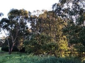
Table 2 Vegetation types and habitat zones identified and mapped in the Site ............................. 13
Table 3 Vegetation quality assessment results .............................................................................. 15
Table 4 Species exempt from a permit requirement under ESO2 .................................................. 16
Table 5 Species exempt from a permit requirement under ESO3 .................................................. 17
Table 6 Species exempt from a permit requirement under SLO2 .................................................. 18
Table 7 Risk matrix for determining the assessment pathway that an application to
remove native vegetation will take ..................................................................................... 24
Table 8 Impacts to native vegetation .............................................................................................. 25
Table 9 MNES considered for North East Link – Templestowe Road Soccer Facilities ................ 38
Table 10 Likely legislative and policy requirements for the Templestowe Road Soccer
Facilities ............................................................................................................................. 39
Figure index
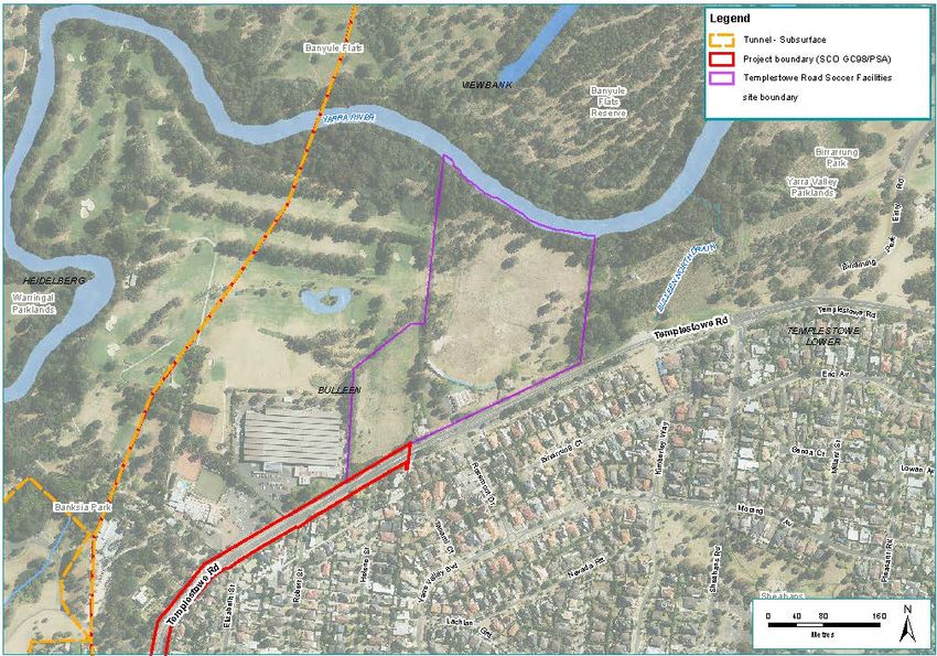
Figure 1 Templestowe Road Soccer Facilities - site boundary.......................................................... 9
Figure 2 Proposed Templestowe Road Soccer Facilities Master Plan .............................................. 9
Figure 3 Ecological values identified at Bulleen Driving Range....................................................... 14
Appendices
Appendix A – Incidental flora observations
Appendix B – Likelihood of occurrence of threatened flora known or predicted within 5 km of
the Site
Appendix C – Fauna species observed during the field assessment
Appendix D – Likelihood of occurrence of threatened fauna known or predicted within 5 km
of the Site
Appendix E – Likelihood of occurrence of Migratory fauna known or predicted within 5 km of
the Site
Appendix F – Canopy Trees and Scattered Trees recorded during the field assessment
Appendix G – EnSym Report
GHD | Report for North East Link Project – Ecology Impact Assesment | vi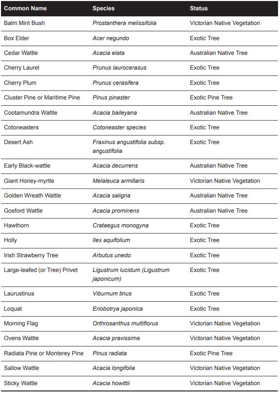
Abbreviations
     Term     Definition

     CaLP     Catchment and Land Protection Act 1994

     CMA      Catchment Management Authority

     DAWE     Department of Agriculture, Water and Environment (formerly DOEE)

     DBH      Diameter at Breast Height (measured 1.3 m from the ground)

     DELWP    Department of Environment, Land, Water and Planning (formerly DEPI and DSE)

     DEPI     Department of Environment and Primary Industries (now DELWP)

     DOEE     Commonwealth Department of the Environment and Energy (now DAWE)

     DSE      Department of Sustainability and Environment (now DELWP)

     EES      Environment Effects Statement (for assessment under the EE Act)

     EMP      Environmental Management Plan

     EPBC     Environment Protection and Biodiversity Conservation Act 1999

     EVC      Ecological Vegetation Class

     FFG      Flora and Fauna Guarantee Act 1988

     GHD      GHD Pty Ltd

     ha       hectare

     Hha      Habitat Hectare

     HZ       Habitat Zone

     km       Kilometres

     LGA      Local Government Authority

     m        Metres

     MNES     Matters of National Environmental Significance

     MTIA     Major Transport Infrastructure Authority

     NELP     North East Link Project

     PER      Public Environment Report (for assessment under the EPBC Act)

     PMST     Protected Matters Search Tool

     PSA      Planning Scheme Amendment

     sp.      Species (one species)

     spp.     Species (more than one species)

     subsp.   Subspecies

     TPZ      Tree Protection Zone

     var.     Variety of a species

                                GHD | Report for North East Link Project – Ecology Impact Assesment | vii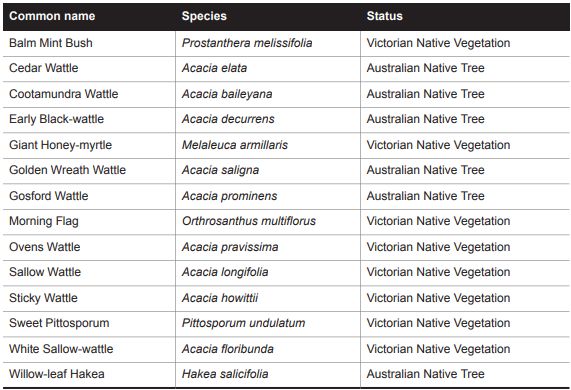
Term    Definition

VBA     Victorian Biodiversity Atlas

VROTS   Species listed on DELWP’s Advisory List of Rare or Threatened Plants in Victoria

WAA     Works Approval Application

WoNS    Weed of National Significance

                          GHD | Report for North East Link Project – Ecology Impact Assesment | viii
1. Introduction
1.1 Project background
The North East Link has undergone an extensive and robust planning and environmental
assessment process. As part of this original approvals phase, North East Link Project
(NELP) published and received public comment on:
An Environment Effects Statement (EES) that presented an integrated assessment
of the potential environmental, social, economic and planning impacts of the
Project, and the proposed approach to managing these impacts. The EES included
an Environmental Management Framework (EMF) containing proposed
Environmental Performance Requirements (EPRs) to avoid, manage and mitigate
identified risks as part of the EES.
A Planning Scheme Amendment (PSA) to facilitate the use and development of the
Project, as well as, establishing a mechanism to protect the tunnels and associated
infrastructure from potential adverse effects of development in their vicinity.
A Works Approval Application (WAA) for the installation of a the road tunnel
ventilation system under Victoria’s Environment Protection Act 1970 that considers
the relevant environmental aspects of the tunnel ventilation system and provides a
detailed discussion to demonstrate that the proposed project reflects best practice.
Additional documents for approval including a Cultural Heritage Management Plan
(CHMP) (not exhibited publicly) and a Public Environment Report (PER) for works
involving matters of national environmental significance (MNES) and works on
Commonwealth land.
The relocation of impacted sport and recreation facilities is required as a consequence of
the North East Link Project. It is proposed to relocate the existing Bulleen Park Soccer
facilities to a new Site at 27 - 59 Templestowe Road Bulleen. The relocation Site includes
two properties (the Bulleen Golf Driving Range at 37-59 Templestowe Road and adjacent
Parks Victoria public land at 27-33 Templestowe Road) in Bulleen, collectively described
as 27-59 Templestowe Road (The Site).
To provide planning approval for the redevelopment, NELP will request the Minister for
Planning prepare, adopt and approve a Planning Scheme Amendment (PSA), under
section 20(4) of the Planning and Environment Act 1987, in the Manningham Planning
Scheme. The PSA would apply the Templestowe Road Soccer Facilities Incorporated
Document, April 2020 (the Incorporated Document) and associated Specific Controls
Overlay Schedule to the Site. NELP will also request the Minister for Planning vary the
designated Project area under the Major Transport Project Facilitation Act 2009 to apply
to the Site.
1.2 Purpose of this report
The purpose of this report is to assess the potential ecological impacts associated with
the redevelopment of the Site to support the proposed PSA to apply to this Site. This
report also provides recommendations for the redevelopment that will inform the
conditions to be prescribed in the Incorporated Document for the Site.
GHD | Report for North East Link Project – Ecology Impact Assesment | 12. Relevant Legislation, Policy and
Guidelines
The following legislation, policy and guidelines apply to terrestrial ecology included in this
report.
2.1 Commonwealth legislation
• Environment Protection and Biodiversity Conservation Act 1999 (EPBC Act)
2.2 State legislation
• Environment Effects Act 1978
• Planning and Environment Act 1987 (P&E Act)
• Flora and Fauna Guarantee Act 1988 (FFG Act)
• Wildlife Act 1975
• Catchment and Land Protection Act 1994 (CaLP Act)
2.3 State policy and guidelines
• Guidelines for the removal, destruction or lopping of native vegetation (DELWP,
2017)
• Advisory List of Rare or Threatened Plants in Victoria (DEPI 2014)
• Advisory List of Threatened Vertebrate Fauna in Victoria (DEPI 2013)
• Advisory List of Threatened Invertebrate Fauna in Victoria (DSE 2009)
GHD | Report for North East Link Project – Ecology Impact Assesment | 23. Methods
3.1 Site and study area
Two terms for the Site are used: Site and study area. Site refers to the specific Site (27-
59 Templestowe Road, Bulleen) proposed for development. Study area refers to a
broader region surrounding the particular Site (i.e. includes areas that are outside the
proposed impact area). The study area for this assessment includes all land and
waterways within 5 kilometres (km) of the Site. This description covers a much broader
area than the expected zone of impact, and the additional information captured has been
used to provide context to assess the significance of ecological features identified within
the Site (for example, whether they are part of a larger area, or whether there are
potential impacts on ecological features outside the Site). The broader study area was
only assessed at a desktop level.
3.2 Existing conditions assessment
3.2.1 Desktop assessment
The following subsections describe the information that was reviewed to provide an
understanding of the ecological values and condition of those values within the Site.
Database Searches
The following databases were searched:
Protected Matters Search Tool 1 (PMST) (maintained by Department of Agriculture,
0F
Water and the Environment (DAWE)) to identify Matters of National Environmental
Significance listed under the Commonwealth Environment Protection and
Biodiversity Conservation (EPBC) Act 1999 (5-km buffer of the Site)
Victorian Biodiversity Atlas 2 (VBA) administered by the Victorian Department of
1F
Environment, Land, Water and Planning (DELWP) (5-km buffer of the Site)
Ecological Vegetation Class (EVC) mapping (2005 and pre-1750) (maintained by
DELWP)
Location Map 3 (maintained by DELWP)
2F
Native Vegetation Extent Map (maintained by DELWP)
NatureKit 4 (maintained by DELWP)
3F
Aerial imagery of the Site.
1
http://www.environment.gov.au/epbc/protected-matters-search-tool (accessed October 2019)
2
https://vba.dse.vic.gov.au/vba/#/ (accessed October 2019)
3
https://nvim.delwp.vic.gov.au/TermsAndConditions?comeFrom=%2fBiodiversity (accessed October 2019)
4
http://maps.biodiversity.vic.gov.au/viewer/?viewer=NatureKit (accessed October 2019)
GHD | Report for North East Link Project – Ecology Impact Assesment | 33.2.2 Field assessment – existing conditions
A field assessment of the Site was conducted by a botanist and a zoologist on 18
October 2019.
The field assessment included:
Identification and mapping of patches of remnant or planted native vegetation
A Habitat-hectares assessment of all patches of native vegetation within the Site, in
accordance with the current method available on the DELWP website
Assessment of the condition of all native vegetation patches
Assessment of the likelihood of occurrence of rare or threatened flora and
communities (based on known or predicted occurrence within 5 km of the Site, and
the presence of suitable habitat)
Assessment of the condition of fauna habitat and identification of the potential for
threatened and migratory fauna to occur within the Site
Collection of inventory of incidental observations of both native and non-native flora
and fauna encountered during the field assessment, together with conservation
status, origin and weed status
Identification of the presence of significant weed species including those declared
under relevant state and national legislation, policy or strategy, e.g. Catchment and
Land Protection Act 1994 (CALP Act) and National Weeds Strategy
3.3 Impact assessment
This study has assessed the potential impacts of construction and operation associated
with the relocation of sporting and recreation facilities on ecological assets and values to
be protected. The impact assessment approach for the Site included:
Establishing the Project context
Determining the existing conditions by using the desktop assessment and field
assessment to establish the likelihood of threatened species presence
Assessing impacts with consideration of:
– The extent and quality of native vegetation that would be impacted during
construction and the quantum of offsets that may be necessary
– The impact to threatened flora and fauna
– Impacts to known and potential fauna habitat (terrestrial and aquatic) within the
study area
– The construction and operation of the Project
Providing mitigation and/or management measures required to avoid, minimise
and/or offset ecological impacts such as the removal of native vegetation.
The loss of native vegetation was determined by overlaying the proposed design,
including temporary laydown and works areas, against the mapped existing conditions,
and identifying any overlap.
GHD | Report for North East Link Project – Ecology Impact Assesment | 4For fauna, the impact assessment only considers impacts above and beyond the current
impacts, as this is already an active public site, with vehicle movements, people, some
noise, lighting including floodlighting, etc. Impacts are considered if they change the
status quo (e.g., increased traffic causing increased death, increased disturbance, etc.).
3.4 Nomenclature
3.4.1 Flora
Common and scientific names for flora follow the VBA (version 3.2.6).
Conservation significance was determined in accordance with the EPBC Act, FFG Act,
and DELWP’s Advisory List of rare or threatened plants in Victoria (DEPI 2014).
The field investigation for flora was undertaken in accordance with GHD’s FFG Act Permit
to take Protected Flora (#10008653; Expires 28 February 2021).
3.4.2 Vegetation communities
Native vegetation in Victoria is classified into units known as EVCs, which are described
according to a combination of floristic, life form and ecological characteristics, and
through an inferred fidelity to particular environmental attributes. Each EVC occurs under
a common regime of ecological processes within a given biogeographic range, and may
contain multiple floristic communities.
Other vegetation types that may occur in Victoria include vegetation communities listed
as threatened under the Commonwealth EPBC Act and/or the Victorian FFG Act. These
two Acts both have vegetation classification systems that are separate to each other and
separate to the EVC classification system. As such, any single patch of native vegetation
would be classifiable as a particular EVC, and it may also be separately classified as a
different vegetation community under the EPBC Act, and/or as another vegetation
community under the FFG Act.
3.4.3 Native vegetation
Native vegetation in this report is defined in accordance with the Guidelines for the
removal, destruction or lopping of native vegetation (DELWP 2017):
Remnant patch – an area of vegetation where at least 25% of total perennial
understorey plant cover is native, or where three or more native canopy trees occur
with an overlapping canopy
Scattered tree – a native canopy tree that does not form part of a patch
Scattered native individuals – native species which do not form a remnant patch,
due to having less than 25% cover in a particular area
3.4.4 Vegetation Quality Assessment
During the field assessment, the quality and quantity of native vegetation within the Site
were assessed in accordance with the ‘Habitat Hectares’ approach, as outlined in the
Vegetation Quality Assessment Manual – guidelines for applying the habitat hectare
scoring method (DSE 2004a). Native vegetation was assessed using version 1.3 of the
‘Vegetation Quality Field Assessment Sheet’ provided by DELWP and EVC benchmarks
for the Gippsland Plain.
GHD | Report for North East Link Project – Ecology Impact Assesment | 53.4.5 Declared noxious weeds and weeds of national significance
During the field assessment, a list of all flora observed within the Site was created (Appendix
A). This includes environmental weeds, which are noxious weeds 5 listed under the 4F
Catchment and Land Protection Act 1994 and Weeds of National Significance 6 (WoNS). 5F
3.4.6 Fauna
Unless otherwise noted, common and scientific names for fauna follow the VBA database
(version 3.2.6).
Fauna conservation significance was determined in accordance with the EPBC Act, FFG
Act, and DELWP’s Advisory List of Threatened Vertebrate Fauna in Victoria or
Threatened Invertebrate Fauna in Victoria (DSE 2013; DSE 2009 respectively).
The field investigation for fauna was undertaken in accordance with GHD’s Wildlife Act
Research Permit and Management Authorisation (#10008401; Expires 31 July 2020).
3.4.7 Fauna communities
Unlike flora and the use of EVCs, there is no official widespread classification system for
fauna communities in Victoria. Both the EPBC Act and the FFG Act list a small number of
fauna communities that are considered to be threatened, at a national or state scale,
respectively. Fauna communities known, or potentially occurring within the Site or
surrounds, are only considered in this report if they are listed under either of these two
Acts.
3.5 Assumptions and limitations
This assessment works under the assumption that no impacts on native vegetation or
fauna habitat will occur outside the Site boundary.
The following assumptions were also applied when undertaking the ecological
assessment:
Ecological limitations
This ecological assessment is restricted to terrestrial vascular plant species (ferns,
conifers and flowering plants) and terrestrial vertebrate fauna (mammals, birds, reptiles
and frogs). Non-vascular flora (e.g. mosses, liverworts, lichens), fungi and terrestrial
invertebrates have not been considered as part of this assessment, except where listed
threatened species are known or suspected to occur, or where bryophytes comprise part
of the EVC benchmark used for the habitat hectare assessment (e.g. cover of
bryophytes). Fish and aquatic invertebrates were not considered as part of this
assessment.
It was beyond the scope of this assessment to undertake detailed flora or fauna survey
methods, such as flora quadrat surveys or fauna trapping. No targeted surveys were
deemed to be required.
5
http://agriculture.vic.gov.au/agriculture/pests-diseases-and-weeds/weeds/invasive-plant-classifications [accessed
October 2019]
6
http://www.environment.gov.au/biodiversity/invasive/weeds/weeds/lists/wons.html [accessed October 2019]
GHD | Report for North East Link Project – Ecology Impact Assesment | 6This ecological assessment is restricted to the 27-59 Templestowe Road Bulleen, and
does not include assessment of ecological values present on adjoining land, including
residential and commercial properties.
The fieldwork used the Collector for ArcGIS mapping application to record Site
information. This mapping tool should be considered to be accurate to within ten metres
on Site.
Use of databases
The Victorian Biodiversity Atlas (VBA) can be used to search a defined geographical area
to produce species lists of flora and fauna that have been recorded historically within the
searched area. The database lists are only as accurate as the quality and quantity of data
that have been recorded and documented from the area. The use of the database in a
desktop assessment has the following limitations:
Location details for many records (typically older records) have a relatively low
degree of accuracy (e.g., within 1 km). Thus, the database search may not pick up
some records of species that were made within the Site historically.
These datasets are not exhaustive. Many locations locally and across Victoria have
a low level of documented survey effort for one or more groups of flora and fauna.
During field assessments, it is not uncommon to find species at locations for which
there are few or no previous nearby database records; however, this is less
common in the greater Melbourne area.
GHD | Report for North East Link Project – Ecology Impact Assesment | 74. Project description
The Site includes two properties (the Bulleen Golf Driving Range at 37-59 Templestowe
Road and adjacent Parks Victoria public land at 27-33 Templestowe Road) in Bulleen,
collectively described as 27-59 Templestowe Road (The Site). A Master Plan has been
developed for the Site that proposes the redevelopment of the Site into a multi-purpose
sporting facility to provide alternative sport and recreation facilities for the current users of
Bulleen Park, described as the ‘Templestowe Road Soccer Facilities Master Plan’ or ‘the
Project’.
The new facilities proposed to be developed on Site will comprise three soccer fields, a
pavilion, club rooms, new shared use paths, bicycle parking facilities, and car parking.
Figure 1 shows the existing conditions and the Site boundary for 27 - 59 Templestowe
Road Bulleen. Figure 2 shows the proposed Templestowe Road Soccer Facilities Master
Plan.
GHD | Report for North East Link Project – Ecology Impact Assesment | 8Figure 1 Templestowe Road Soccer Facilities - site boundary
Figure 2 Proposed Templestowe Road Soccer Facilities Master Plan
GHD | Report for North East Link Project – Ecology Impact Assesment | 95. Existing conditions
5.1 Site description
The Site includes two properties (the Bulleen Golf Driving Range at 37-59 Templestowe
Road and adjacent Parks Victoria public land at 27-33 Templestowe Road) in Bulleen,
collectively described as 27-59 Templestowe Road (The Site).
The Site is associated with the southern flood plain of the Yarra River (the northern
boundary of the Site meets the river), and lies immediately north of a residential part of
the suburb of Bulleen, characterised by housing, roads, landscaped verges, parks and
gardens. The area lies within the Manningham City Council area, Port Phillip and
Westernport Catchment Management Authority (CMA) area and the Gippsland Plain
(GipP) bioregion.
5.2 Existing conditions – Flora
5.2.1 Site overview
The Site occurs within a broad urban setting that has been largely cleared of indigenous
native vegetation. Four primary vegetation types occur on the Site.
1. Introduced grassland. The majority of the Site supports mown (golf driving range)
or periodically slashed (adjacent title to the west of the driving range) introduced
grassland, characterised by a range of common weedy grasses and forbs. Native
species are absent from this vegetation type.
2. Planted vegetation. Much of the woody (treed) vegetation that is present in the
Site has been planted for amenity purposes, and comprises a range of locally
indigenous native trees, non-indigenous native trees, and introduced species.
3. Native vegetation patches. Three small patches of native vegetation comprising
Floodplain Riparian Woodland (EVC 56) occur within the Site. All patches appear
to have colonised previously cleared areas in recent decades, as indicated by
Plate 1.
4. Scattered native trees. A number of scattered native trees (both large and small)
occur within the broader matrix of introduced grassland vegetation. While the
majority of the scattered trees on the block of land to the west of the driving range
are small trees, it is possible that these have colonised naturally (i.e. there is no
evidence that they have been planted); therefore, they are regarded as not being
exempt from requiring a permit for removal under the Planning and Environment
Act 1987.
Aerial photography from 1945 7 provides evidence of past clearing and subsequent
6F
replacement of most of the native vegetation, except for a narrow strip along the Yarra
River (Plate 1).
7
https://1945.melbourne/ (accessed October 2019)
GHD | Report for North East Link Project – Ecology Impact Assesment | 10Plate 1 The Site - imagery from 1945 (left) and current (right)
5.2.2 Species summary
The VBA has records of 1,124 flora within 5 km of the Site. These include 587 native
species, 517 introduced species, and 20 non-indigenous natives. During the field
assessment, 56 species were recorded, including seven native and 49 introduced species
(Appendix A).
5.2.3 Weeds
Five noxious weeds were identified within the Site that are listed as either Restricted or
Regionally Controlled in the Port Phillip and Westernport region under the CALP Act. Two
weeds are also listed as WoNS (Appendix A).
Allium triquetrum (Angled Onion) – Restricted
Cirsium vulgare (Spear Thistle) – Controlled
Hypericum perforatum subsp. veronense (St John’s Wort) – Controlled
Lycium ferocissimum (African Box-thorn) – WoNS
Rubus fruticosus spp. agg. (Blackberry) – Controlled, WoNS
5.2.4 Threatened flora and vegetation
EPBC Act Threatened Ecological Communities
Four threatened ecological communities listed under the EPBC Act are known, likely or
may occur within the broader study area (PMST):
Grassy Eucalypt Woodland of the Victorian Volcanic Plain (listed as Critically
Endangered)
Natural Damp Grassland of the Victorian Coastal Plains (listed as Critically
Endangered)
Natural Temperate Grassland of the Victorian Volcanic Plain (listed as Critically
Endangered)
White Box-Yellow Box-Blakely's Red Gum Grassy Woodland and Derived Native
Grassland (listed as Critically Endangered)
GHD | Report for North East Link Project – Ecology Impact Assesment | 11None of these ecological communities were identified in the Site during the field
assessment, nor are they considered likely to occur, owing to a lack of suitable habitat.
Rare, threatened or protected flora
In total, 28 species of rare or threatened flora have been recorded (VBA) or are predicted
(PMST) to occur within 5 km of the Site (Appendix B):
10 species listed under the EPBC Act
10 species listed as threatened under the FFG Act
27 species recognised as rare or threatened in Victoria (DEPI 2014)
No species listed as rare or threatened under the EPBC Act, FFG Act or DELWP
Advisory List were recorded in the Site.
No species protected under the FFG Act were recorded in the Site (Appendix A).
Owing to its high degree of modification, and weedy understorey, it is unlikely that any
rare or threatened flora occur in the Site.
5.2.5 Vegetation Quality Assessment
Ecological Vegetation Classes
Remnant native vegetation in the study area has been mapped by DELWP at a scale of
1:25,000. Two EVCs are modelled in the Site under the 2005 mapping:
• Plains Grassy Woodland (EVC 55)
• Floodplain Riparian Woodland (EVC 56)
The field assessment identified areas of native vegetation consistent with one EVC (Table 2):
Floodplain Riparian Woodland (EVC 56).
Habitat Zones
In total, 0.208 ha of remnant patches of native vegetation consisting of one Habitat Zone
was recorded and mapped in the Site. The Habitat Zone is described in Table 2 and the
results of the habitat hectare assessment are presented in Table 3. Habitat zone
descriptions are based on representative patches; however, conditions may vary slightly
between different patches. EVCs and their habitat zones are mapped in Figure 3.
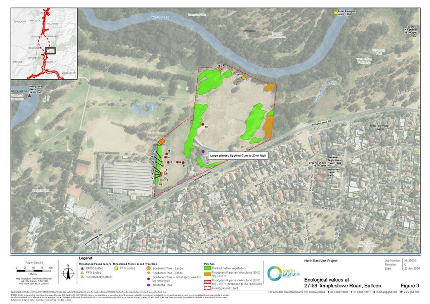
Scattered trees
A total of 23 scattered trees (one large; 22 small) occur within the Site (Appendix F).
Large trees in patches
No large trees occur within patches of native vegetation within the Site.
GHD | Report for North East Link Project – Ecology Impact Assesment | 12Table 2 Vegetation types and habitat zones identified and mapped in the Site
HZ EVC EVC Description Photo
No. NO.
HZ1 Floodplain 56 Habitat Zone 1 comprises modified Floodplain Riparian Woodland, which
Riparian has colonised small areas around the margin of the Site. The canopy,
Woodland where present, consists of Eucalyptus camaldulensis (River Red-gum) to 18
m high, with most individuals appearing to have naturally colonised, while
some have been planted. The midstorey (where present – only in the patch
on the eastern boundary) comprises Acacia dealbata (Silver Wattle), Acacia
melanoxylon (Blackwood) and Melicytus dentatus (Tree Violet). Apart from
scattered Juncus sp. (Rush), the ground layer is dominated by introduced
species including Avena sp. (Oat), Cenchrus clandestinus (Kikuyu), Dactylis
glomerata (Cocksfoot), Ehrharta erecta (Panic Veldt-grass), Ehrharta
longifolia (Annual Veldt-grass) and Rubus fruticosus spp. agg. (Blackberry).
GHD | Report for North East Link Project – Ecology Impact Assesment | 13Figure 3 Ecological values identified at Bulleen Driving Range
\\ghdnet\ghd\AU\Melbourne\Projects\31\35006\GIS\Maps\PDF\Operational\Ecology\Sports_and_Recreation_Ecology\3135006_Sports_Rec_Ecology_Bulleen
_Driving_Range_A4L_RevC_20200626.pdf
GHD | Report for North East Link Project – Ecology Impact Assesment | 14Table 3 Vegetation quality assessment results
Habitat Zone 1
Bioregion Gippsland Plain
EVC Floodplain Riparian Woodland
(EVC 56)
Bioregional Conservation Status (BCS) Endangered
Large old trees 0
Tree canopy cover 5
Lack of weeds 0
Understorey 5
Recruitment 10
Organic litter 2
Logs 0
Total Site score 22
Patch size 8
Neighbourhood 0
Distance to Core Area 4
Landscape context score 12
Habitat score 34
Habitat Condition Score 0.34
5.2.6 Council Overlays
A number of environmental overlays are present within or immediately adjacent to the Site
under the Manningham Planning Scheme.
ESO2 – Sites of Biological Significance (immediately adjacent to northern end of Site,
along the Yarra River)
The ESO2 requires a permit to remove, destroy or lop:
Victorian native vegetation
A dead eucalypt tree that is both:
– More than 20 m from a building (excluding fences) to the base of the trunk
– More than 1 m in circumference, measured at a height of 1.3 m above natural ground
level
A permit is not required for:
Dead vegetation except for dead eucalypt trees as specified above
Any species listed as exempt from a permit requirement in the Table to this Schedule
(Table 4)
GHD | Report for North East Link Project – Ecology Impact Assesment | 15Table 4 Species exempt from a permit requirement under ESO2
No vegetation within the Site occurs within this overlay. However, it should be noted that this
overlay is situated immediately adjacent to the northern boundary of the Site, and any tree
pruning on the northern boundary (unlikely to be required) may need to have regard to the
conditions of this overlay.
ESO3 – Buffer Conservation Areas Supporting Sites of Biological Significance (entire
Site)
The ESO3 requires a permit to remove, destroy or lop:
Victorian native vegetation
An Australian native tree that has either:
– A trunk circumference of more than 0.35 m measured at a height of 1.3 m above
natural ground level
– A height of more than 6 m
A dead eucalypt tree that is both:
– More than 20 m from a building (excluding fences) to the base of the trunk
– Greater than 1 m in circumference, measured at a height of 1.3 m above natural
ground level
A permit is not required for:
Dead vegetation except for dead eucalypt trees as specified above.
Any species listed as exempt from a permit requirement in the Table to this Schedule
(Table 5)
16 | GHD | Report for North East Link Project – Ecology Impact AssesmentTable 5 Species exempt from a permit requirement under ESO3
The implications of this overlay are that any tree native to Australia, but not locally indigenous,
requires a permit for removal if it is >6 m in height or >35 cm in diameter. This will apply to many
of the areas mapped as planted native vegetation.
A description of vegetation in the Site that is within the ESO3 is provided in Table 2 under
Floodplain Riparian Woodland (EVC 56).
SLO2 – Yarra (Birrarung) River Corridor Environs (entire Site)
The SLO2 requires a permit to remove, destroy or lop vegetation, except for:
Non-native vegetation which has all of the following:
– A trunk circumference of less than 0.35 m at 1 m above ground level
– A height of less than 6 m
– A branch spread of less than 4 m
Vegetation listed in Table 1 to this schedule (Table 6)
GHD | Report for North East Link Project – Ecology Impact Assesment | 17Table 6 Species exempt from a permit requirement under SLO2
All patches of native vegetation and scattered native trees on the Site meet the definition of a
significant tree under this overlay.
18 | GHD | Report for North East Link Project – Ecology Impact Assesment5.3 Existing conditions – Fauna
5.3.1 Species overview
A total of 326 terrestrial fauna species (304 native and 22 non-native) are known (VBA) to occur
within the study area (i.e., within 5 km of the Site), or are predicted to occur within the study
area (PMST).
Of the native species, 55 are listed as threatened, including 22 listed under the EPBC Act, 43
listed under the FFG Act, and 47 listed under the DELWP Advisory lists of threatened vertebrate
or invertebrate fauna in Victoria (DSE 2013, 2009 respectively).
A total of 18 species (all birds) identified for the study area are listed as Migratory under the EPBC
Act. The Marine status of fauna species (as indicated under the EPBC Act) was not considered
because the Site is not in or near a Commonwealth marine area.
Thirty-three species (four mammals, 27 birds, one reptile and one frog) were recorded during
the field assessment (Appendix C). No threatened or migratory fauna were observed during the
field assessment.
5.3.2 Habitat value
At a broad scale, the Melbourne area is considerably urbanised and fragmented as a result of
historical land clearance. However, the Site itself is within an area of relatively high ecological
value. It abuts the Yarra River within an area that is not urbanised. Forests and woodlands
along the Yarra River are the most extensive areas of vegetation that remain within this part of
Melbourne. These areas of high-value habitat attract and support a range of common,
uncommon and rare fauna, including threatened species (Plate 2). These areas tend to be
subject to fewer ongoing disturbances than more urbanised areas so often retain habitat
features that other habitat types have now lost, such as leaf-litter, coarse woody debris, hollow-
bearing trees and large trees. One of the main values of this habitat is as a wildlife corridor
which facilitates landscape-scale movement of fauna, linking otherwise isolated areas of habitat.
The Yarra River habitats support fauna such as Macropods (Eastern Grey Kangaroo Macropus
giganteus and Black Wallaby Wallabia bicolor), Common Wombat Vombatus ursinus, Short-
beaked Echidna Tachyglossus aculeatus and Sugar Glider Petaurus breviceps. This habitat
also tends to have a greater diversity of bird fauna (beyond the common, adaptable and often
aggressive parrots and honeyeaters), including thornbills (Brown Thornbill Acanthiza pusilla,
Yellow-rumped Thornbill Acanthiza chrysorrhoa), kingfishers (Azure Kingfisher Alcedo azurea,
Sacred Kingfisher Todiramphus sanctus), Superb-fairy Wren Malurus cyaneus, smaller
honeyeaters (such as the Eastern Spinebill Acanthorhynchus tenuirostris, White-plumed
Honeyeater Lichenostomus penicillatus) and waterbirds such as crakes, rails and waterfowl.
Frogs (such as the Common Froglet Crinia signifera, Southern Brown Tree Frog Litoria ewingi
and Spotted Marsh Frog Limnodynastes tasmaniensis) and reptiles (such as the Tiger Snake
Notechis scutatus) are also likely to be found in these areas.
Away from the river, the habitat within this Site more closely resembles fragmented
forest/woodland and scattered tree habitat commonly associated with golf courses (Plate 3).
The value of this habitat varies, depending on the size and quality of the tree patches (for
example, the presence of hollow-bearing trees, vegetation layers, leaf litter and fallen limbs and
logs) and connectivity to other patches. Golf course habitat along the Yarra River provides some
habitat for native fauna, but is often dominated by common and aggressive bird species such as
Noisy Miner Manorina melanocephala and Rainbow Lorikeet Trichoglossus haemotodus.
Occasionally or rarely, larger flowering trees may attract foraging threatened fauna such as
Swift Parrot and Grey-headed Flying-fox. Mowed grassy areas tend to be of low value to native
fauna. That said, all non-developed green space in this area contributes to the value of the
corridor and habitat for fauna.
GHD | Report for North East Link Project – Ecology Impact Assesment | 19Plate 2 High value riparian habitat along Plate 3 Scattered trees and
the Yarra River at the north of the Site fragmented habitat associated with
the golf driving range
5.3.3 Fauna of conservation significance
Fauna of conservation significance include species that are:
Listed as threatened or Migratory under the Commonwealth Environment Protection and
Biodiversity Conservation Act 1999
Listed as threatened under the Victorian Flora and Fauna Guarantee Act 1988
Listed as threatened on the DELWP Advisory List of Threatened Vertebrate Fauna in
Victoria (DSE 2013) or the DSE Advisory List of Threatened Invertebrate Fauna in
Victoria (DSE 2009) (excluding species listed as ‘near-threatened’ or ‘data deficient’ that
are not included on the FFG or EPBC Act lists)
EPBC Act 1999 - Threatened species
Of the species recorded within the study area (VBA data), 11 are listed as threatened under the
EPBC Act. The PMST identifies a further 11 species that might occur within the study area, but
for which there are no historical records. Thus, in total, 22 species listed as threatened under
the EPBC Act were considered for the Project. These include seven mammals, 11 birds, one
reptile, one frog and two invertebrates. Given the habitats favoured by these species, and the
type, extent and condition of habitats represented within the Site, most of these species are
considered unlikely to occur within or visit the Site. An account of all threatened species, with a
likelihood of occurrence evaluation, is provided in Appendix D. Four species listed as threatened
under the EPBC Act may use habitats within or above the Site:
Regent Honeyeater Xanthomyza phrygia (Critically Endangered): This species visits open
forests and woodlands, particularly dry woodlands and forests dominated by Box Ironbark
eucalypts. It is generally absent from very wet and very dry areas. May now be restricted
to the Chiltern-Mt Pilot National Park (NE Victoria) following population decline and range
contraction. There are numerous historical records across Melbourne’s suburbs, including
along the Yarra River, all prior to 1998. This species may be a rare foraging visitor to
large flowering trees within the Site.
Swift Parrot Lathamus discolor (Critically Endangered): This species is a winter migrant to
Victoria and other parts of SE Australia from breeding areas in Tasmania. In Victoria, it
prefers dry, open eucalypt forests and woodlands, especially Box Ironbark Forest in
north-central Victoria. Each year, Swift Parrots migrate through the Melbourne area,
occasionally stopping to forage in suitable flowering trees, usually eucalypts. The species
is occasionally recorded in urban parks, gardens, street trees and golf courses with
flowering ornamental trees and shrubs. The VBA contains 29 historical records of this
20 | GHD | Report for North East Link Project – Ecology Impact Assesmentspecies within the study area, most recently in 2018. It is considered possible that this
species may opportunistically forage within some of the larger scattered eucalypt trees
within the Site occasionally or rarely. However, there is no evidence to suggest that
individuals favour any patches of trees in this immediate area.
White-throated Needletail Hirundapus caudacutus (Vulnerable): This species is reportedly
almost exclusively aerial within Australia, occurring in the airspace over most types of
habitat, particularly wooded areas. The VBA contains 82 historical records of this species
within the study area, most recently in 2019. This species is likely to be a regular foraging
visitor to the airspace above Site.
Grey-headed Flying-fox Pteropus poliocephalus (Vulnerable): This species uses a wide
range of habitats in Victoria, from lowland rainforest and coastal stringybark forests to
agricultural land and suburban gardens. It favours densely vegetated flowering and
fruiting trees, including trees across Melbourne’s suburbs. There is a large established
colony in Yarra Bend Park in Melbourne, downstream of the Site. The VBA contains 22
historical records of this species within the study area, most recently in 2018. This
species is likely to be a regular foraging visitor to large flowering trees within the Site.
However, habitat of a similar quality and extent is present and common in the surrounding
area, so it is unlikely that this species depends on trees within the Site.
EPBC Act 1999 –Migratory Fauna
Of the species recorded within the study area (VBA data), ten are listed as Migratory under the
EPBC Act. The PMST identifies a further eight species that might occur within the study area,
but for which there are no historical records. Thus, in total, 18 species listed as Migratory under
the EPBC Act were considered for the Project, all birds. Most of these species favour wetlands
or coastal habitats and are considered unlikely to occur within or visit the Site. An account of all
Migratory species, with a likelihood of occurrence evaluation, is provided in Appendix E.
Four Migratory species may occur within the Site. Two aerial species (Fork-tailed Swift Apus
pacificus and White-throated Needletail Hirundapus caudacutus) may forage in the airspace
above the Site occasionally or rarely, but are very unlikely to use terrestrial habitats within the
Site. Two species of fantail/flycatcher (Satin Flycatcher Myiagra cyanoleuca and Rufous Fantail
Rhipidura rufifrons) may visit the dense vegetation associated with the Yarra River in the
warmer months of the year.
In terms of the EPBC Act, an action is likely to have a significant impact on a Migratory species
if there is a real chance or possibility that it will:
Substantially modify (including by fragmenting, altering fire regimes, altering nutrient
cycles or altering hydrological cycles), destroy or isolate an area of important habitat for a
migratory species
Result in an invasive species that is harmful to the migratory species becoming
established in an area of important habitat for the migratory species
Seriously disrupt the lifecycle (breeding, feeding, migration or resting behaviour) of an
ecologically significant proportion of the population of a migratory species
Work within this Site would not be expected to have a significant impact on any Migratory
species, population or important habitat with respect to these criteria.
FFG Act 1988 – threatened species
Forty-three species identified for the study area are listed as threatened fauna under the FFG
Act, and 33 of those have been previously recorded within the study area (VBA). Twenty-one
species are also listed as threatened under the EPBC Act and were considered above. Of the
GHD | Report for North East Link Project – Ecology Impact Assesment | 21You can also read