CITY OF LONDON TALL BUILDINGS EVIDENCE PAPER - September 2010
←
→
Page content transcription
If your browser does not render page correctly, please read the page content below
CITY OF LONDON
 TALL BUILDINGS
EVIDENCE PAPER

     September 2010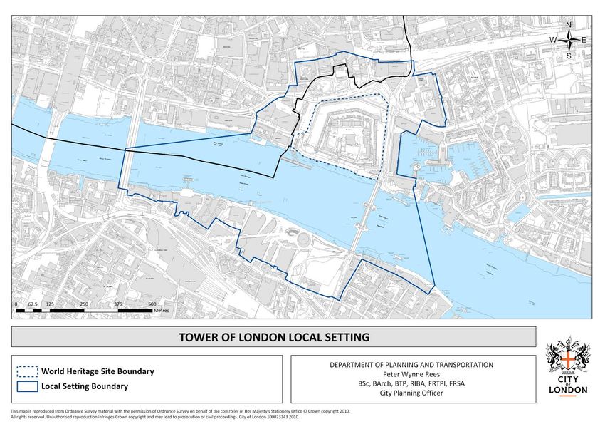
CONTENTS
1. Introduction 6
1.1 The City of London 6
1.2 Definition of Tall Buildings in a City Context 6
1.3 Methodology 7
1.4 Structure of the paper 9
2. Policy Context 10
2.1 National Guidance 10
2.1.1 PPS 1 10
2.1.2 PPS 5 10
2.1.3 CABE / English Heritage Guidance on Tall Buildings (2007) 10
2.2 Regional Guidance 11
2.2.1 London Plan 11
2.2.2 City Fringe 12
2.3 Economic Growth in the City 12
3. Policy History and Evolution 14
3.1 Development of Tall Buildings Related Policy in the City of London 14
3.1.1 London Building Acts 14
3.1.2 St. Paul’s Heights (1938) 14
3.1.3 Reconstruction in the City of London (1947) 14
3.1.4 County of London Plan (1951 & 1962) 15
3.1.5 Greater London Development Plan (1976) 15
3.1.6 Smithfield District Plan (1981) 16
3.1.7 City of London Local Plan (1989) 16
3.1.8 City of London Unitary Development Plan (UDP) (1994) 17
3.1.9 City of London Unitary Development Plan (UDP) (2002) 17
3.1.10 London Plan (2004–2008) 18
3.1.11 Conclusions 18
3.2 Tall Buildings Policy Timeline 19
4. Urban Characterisation 21
4.1 The Urban Character of the City 21
4.1.1 Historical development 21
4.2 General urban design considerations for tall buildings 24
4.3 The Distribution of Tall Buildings 24
4.4 Approved tall building proposals 26
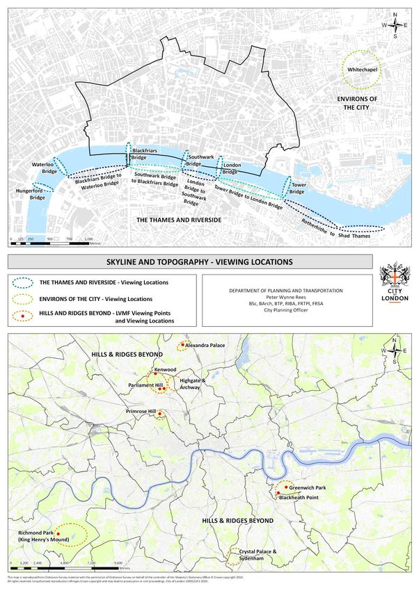
4.5 Skyline and Topography of the City 28
4.5.1 The Thames and Riverside 28
4.5.2 Environs of the City 30
4.5.3 More distant hills and ridges 30
5. Heritage Assets 32
5.1 Conservation Areas 32
5.1.1 Settings of Conservation Areas 35
5.1.2 Conservation Area Character Summaries / Management Plans 36
5.1.3 Conservation Areas: Conclusions 36
5.2 Listed Buildings 37
5.3 Historic City Landmarks 37
5.4 Archaeology and Scheduled Ancient Monuments 40
5.5 Historic Parks and Gardens 40
6. Protected Views and Settings 43
6.1 Views and Setting of the World Heritage Site 43
6.2 London View Management Framework 45
2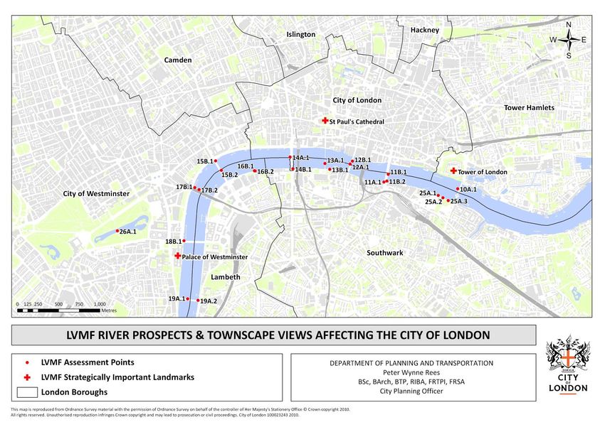
6.2.1 Policy Development                                                                  45
6.2.2 River Prospects and St. James’ Park View                                            52
6.3 St. Paul’s Cathedral: Local Views and Setting                                         54
6.3.1 Infringements of the heights                                                        57
6.3.2 Backdrop to the views                                                               59
6.3.3 St. Paul’s Heights: Conclusions                                                     61
6.4 Monument Views                                                                        61
6.5 Tall Buildings that have been demolished                                              64

7. Other Planning Considerations                                                          65
7.1 Thames Policy Area                                                                    65
7.2 Tall Buildings and Transport                                                          67
7.3 London’s Airports                                                                     68
7.4 Environmental effects                                                                 71
7.5 Mixed use                                                                             71
7.6 Other Relevant Plans and Strategies in the City                                       72
7.6.1 Enhancing the Public Realm in the Eastern Cluster (2005)                            72
7.6.2 St. Helens Square and Vicinity – Enhancing the Public Realm (2007)                  72
7.6.3 Barbican Listed Building Management Guidelines SPD (Volume I & II) (2005)           73
7.6.4 Golden Lane Listed Building Management Guidelines SPD (2007)                        73
7.6.5 Tall Buildings and Sustainability (2002)                                            73

8. Conclusion                                                                             74
8.1 Regional planning context                                                             74
8.2 Local policies                                                                        74
8.3 Areas inappropriate for tall buildings                                                76
8.4 Areas sensitive to tall buildings                                                     78
8.5 Tall Building Clusters                                                                78
8.6 The Eastern Cluster                                                                   79
8.7 Other considerations                                                                  83
8.8 Summary                                                                               83
8.9 Policy                                                                                84

9. References                                                                             86

Appendices                                                                                88

Appendix A. Tall Buildings over 75m AOD in the City of London (Existing and Permitted).   88
Appendix B. Conservation Area Character Summaries.                                        92
Appendix C. Conservation Area Management Strategies.                                      93
Appendix D. Comparison of Strategic Views and Protected Vistas 1991 / 2007 / 2010.        94

                                                     3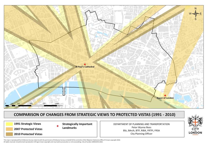
LIST OF FIGURES
Figure 1. City of London employment projections. 13
Figure 2. Development and height control limitations timeline. 20
Figure 3. Tall Building distribution in the City. 27
Figure 4. Viewing locations in the City. 31
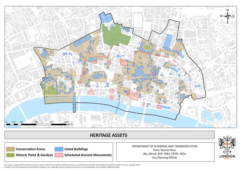
Figure 5. Heritage Assets in the City. 33
Figure 6. Conservation Areas in the City. 34
Figure 7. Historic City Landmarks. 39
Figure 8. Scheduled Ancient Monuments in the City. 41
Figure 9. Historic Parks and Gardens in the City. 42
Figure 10. Tower of London Local Setting Area. 44
Figure 11. Components of a Protected Vista. 46
Figure 12. Strategic Views 1991 – coverage in the City of London. 48
Figure 13. London View Management Framework Protected Vistas (2007). 49
Figure 14. London View Management Framework Protected Vistas (2010). 50
Figure 15. Comparison of changes from Strategic Views to Protected Vistas 51
1991 – 2010.
Figure 16. LVMF River Prospects and Townscape Views affecting City of London tall buildings. 53
Figure 17. St. Paul’s Heights Policy Area. 56
Figure 18. Buildings that infringe St. Paul’s Heights. 58
Figure 19. Monument Views Policy Area. 63
Figure 20. Thames Policy Area. 66
Figure 21. Public transport in the City of London. 69
Figure 22. London City Airport Safeguarding Area. 70
Figure 23. Tall Buildings in the City by Height. 75
Figure 24. Summary of Tall Building Constraints. 77
Figure 25. Anticipated Distribution of Development (% of floorspace and % of residential 80
units).
Figure 26. Eastern Cluster (LDF Core Strategy). 81
Figure 27. Major Schemes in the Eastern Cluster. 82
Figure 28. Tall Buildings in the City of London. 85
4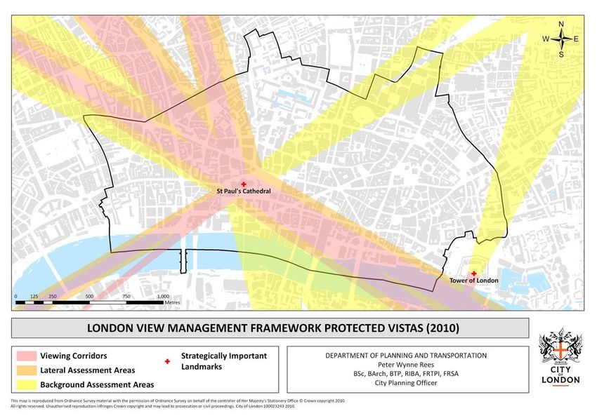
5
1. Introduction

1.1 The City of London
The City of London is internationally recognised as the world’s leading financial and business
centre. The firms and institutions located here require a growing supply of high-quality,
modern office accommodation, and the ‘Square Mile’s’ dynamic economy generates a high
level of development activity.

The City’s economy and employment levels are predicted to grow substantially in the longer
term, notwithstanding current short to medium term economic conditions. This will create
demand for a significant increase in office and other commercial floorspace. While the City’s
residential population is small, the number of dwellings is also expected to rise. As all land in
the City is already developed, this increase in both commercial and residential
accommodation will be achieved through the redevelopment of existing buildings at higher
density. Taller buildings will be one means by which this intensification can be achieved.

Since the 1960s considerable numbers of tall buildings have been constructed in the City, and
form a distinctive and characteristic element of parts of its townscape and skyline. The
expected growth in the economy will mean that further proposals for tall buildings will be
brought forward in future.

The City of London is preparing a Core Strategy as part of its Local Development Framework.
The Core Strategy should contain a clear and robust policy to guide tall development.

The City has long been densely developed, and tall buildings are a modern expression of this.
Tall buildings have very considerable impact on both their local surroundings and the London
skyline. The City has a high quality of environment and is the most historically important area
of London, so increased density will not be appropriate on all sites. Tall buildings provide a
means of bringing about an increase in the total floorspace in the City by accommodating
development on suitable sites and relieving pressure on those where intensification would be
harmful. The Core Strategy’s policy therefore needs to be based on a thorough process of
identifying those locations where tall buildings would be regarded as either appropriate or
unacceptable.

1.2 Definition of Tall Buildings in a City Context
“Guidance on tall buildings”, issued by English Heritage and the Commission for Architecture
and the Built Environment, states that “it is not considered useful or necessary to define
rigorously what is and what is not a tall building. The simplest definition would be to take a
height threshold. However, a judgement as to whether a building can be considered tall is
strongly influenced by its surroundings. The general height, scale and density of the
townscape varies greatly from place to place. The EH/CABE guidance notes that “it is clearly
the case that a ten storey building in a mainly two-storey neighbourhood will be thought of as
a tall building by those affected, whereas in the centre of a large city it may not. The
assessment is therefore a relative one.

The London Plan (paragraph 4.119) defines tall buildings as those “that are significantly taller
than their surroundings and/or have a significant impact on the skyline and are larger than the
threshold sizes set for the referral of planning applications to the Mayor.” The height
threshold for planning applications that need to be referred to the Mayor is 150m in most of
the City, which is considerably higher than anywhere else in London. This threshold height

                                               6
would exclude many buildings that would otherwise be considered tall, and so this definition is
not appropriate for the City’s Core Strategy or this report.

The City of London Unitary Development Plan (UDP) 2002 defined tall buildings as those
which “significantly exceed the height of their surroundings.” This definition has been
contained in the City’s development plans since the 1989 Local Plan. The definition allows a
qualitative decision to be made as to whether a building is regarded as tall according to its
context and so is used in this report.

This definition would include a number of listed historic buildings, such as churches, some of
which are significantly taller than their surroundings. However, the policies of the London Plan,
the current UDP and Core Strategy are concerned with proposals for tall office, residential
and other commercial accommodation. Therefore, the term “tall building” when used in this
report does not apply to pre-war listed buildings.

For consistency, a height threshold of 75m AOD for the purposes of the maps and tabulated
information has been used in this report, unless otherwise stated.

1.3 Methodology
The following table summarises the approach the City is taking to identifying suitable locations
for tall buildings.

                                               7
•     1 Heritage assets including:
                                                       Views and setting of World Heritage Sites
                                                       Scheduled Ancient Monuments and
                                                       archaeological remains
             1. EVALUATION OF                          Conservation Areas and their settings
             HISTORIC CONTEXT                          Listed Buildings
                                                       Historic Parks and Gardens
                                                 •     2 St. Paul’s Heights
                                                 •     3 Monument Views
                                                 •     4 Strategic Views
                                                 •     5 River Prospects
                                                 •     6 Historic City Landmarks

                                                 •     Skyline / Topography
                                                 •     Proximity to major transport interchanges
                                                 •     Potential for open space / urban grain /
                                                       public realm improvements / pedestrian
NATIONAL /       2. URBAN                              capacity
 REGIONAL    CHARACTERISATION                    •     Mixed use
GUIDANCE
                                                 •     Tall buildings that have been demolished and
                                                       replaced
                                                 •     Urban design considerations

                                                 •     Existing scale of development and approved
                                                       tall building proposals
                                                 •     Thames Policy Area
                                                 •     Rights of Way, permeability
             3. EVALUATION OF                    •     Relevant plans and strategies
              THE CITY’S LOCAL                   •     Economic benefits of tall buildings in the City
                 CHARACTER                       •     Relationship to tall buildings within and
                                                       outside the City
                                                 •     Potential impact on London’s Airports

                                     OUTCOMES:       Appreciation of City context of development
                                                     Overview of constraints to tall building development
                                                     Overview of sensitivities to tall building development
                                 8                   Overview of appropriate locations for tall buildings
1.4 Structure of the paper

This paper sets out the approach to establish locations that are inappropriate for, sensitive to
and appropriate for tall buildings in the City of London to inform the City’s Local Development
Framework (LDF) Core Strategy. This paper supports Policy CS14: Tall Buildings.

The following themes will be addressed:

•   Section 1 has defined the need for a policy evidence base on tall buildings in the City of
    London and provided a methodology for the evidence paper.
•   Section 2 describes the relevant national, regional and local guidance.
•   Section 3 describes the evolution of policy relating to tall buildings in the City from the
    early 20th century to the present day.
•   Section 4 provides an urban characterisation of the City, describing the historical
    development of tall buildings in the City, the existing scale of development, the skyline
    and topography of the City and urban design considerations relevant to tall buildings.
•   Section 5 details and explains heritage assets in the City and their relation to tall building
    development in the City.
•   Section 6 explains how protected views and World Heritage Site policies reflect tall
    building development.
•   Section 7 details other planning considerations that are relevant to tall buildings policy in
    the City of London.
•   Section 8 concludes by identifying the areas of the City of London that are inappropriate
    or sensitive to tall buildings and criteria for assessing proposals. This informs the LDF Core
    Strategy policy.

                                                9
2. Policy Context
The City of London’s Local Development Framework is required to take account of polices
operating at national and regional level. National guidance is issued by the Secretary of
State for Communities and Local Government, other branches of government and its agencies.
In London, regional policies are prepared by the Mayor.

2.1 National Guidance

2.1.1 PPS 1

National planning guidance is set out in Planning Policy Statements (PPS) issued by the
Secretary of State. PPS1: ‘Delivering sustainable development’ contains guidance on
development and design that applies generally to all forms of development, including tall
buildings. It states that local planning authorities should concentrate on guiding the overall
scale, density, massing, height, landscape, layout and access of new development. However,
policies for tall buildings are considered to be a local matter and are not explicitly addressed
by PPS1.

2.1.2 PPS 5

The general guidance contained in other PPSs also needs to be taken into account, although
none refers specifically to tall buildings. For example, PPS 5: ‘Planning for the historic
environment’ contains guidance on the conservation of the historic environment including
heritage assets such as listed buildings, scheduled ancient monuments and conservation areas.

2.1.3 CABE / English Heritage Guidance on Tall Buildings (2007)

The CABE and English Heritage Guidance on Tall Buildings (2007) advises local planning
authorities to consider the scope for tall buildings, where they are a possibility, as part of
strategic planning. This may include how they contribute to areas of change. In identifying
locations where tall buildings would and would not be appropriate, local planning authorities
should, as a matter of good practice, carry out a detailed urban design study. This will
support the policy approach the City is taking regarding tall buildings. This report has been
prepared in conformity with this guidance.

                                              10
2.2 Regional Guidance
2.2.1 London Plan
The London Plan sets out strategic planning policy for the whole of Greater London and the
City’s Core Strategy is required to be in general conformity with it. The London Plan was first
published in 2004, has been altered on several occasions, and was published in consolidated
form in February 2008. A replacement London Plan is in preparation, but is not expected to
come into force until late 2011. The London Plan contains a number of objectives and policies
relevant to tall buildings.
The London Plan identifies the capital is a ‘world city’ and predicts substantial growth in its
economy, employment and population in the period up to 2026. This growth is driven
particularly by the financial services sector, concentrated in central London and especially the
City. The Plan aims to accommodate this growth within London and without encroaching on the
green belt or open space. It seeks to achieve this by an overall increase in the density of
building on previously developed land, making London a more compact city, while enhancing
the quality of the environment.
Chapter 4B of the London Plan sets out design principles for a compact city. While all of
these policies are of some relevance to tall buildings, the following are of particular
importance:
4B.9 Tall buildings – location
4B.10 Large-scale buildings – design and impact
4B.16 London View Management Framework
4B.17 View management plans
4B.18 Assessing development impact on designated views
Policies 4B.9 and 4B.10 state that the development of tall buildings should be promoted in
suitable locations and that Development Plan Documents may identify areas that could be
sensitive to tall buildings. The policies set out detailed criteria to be taken into account in
assessing proposals for tall buildings.
11Policies 4B.16, 4B.17 and 4B.18 deal with the London View Management Framework (LVMF),
which protects and manages defined views, identified as ‘London Panoramas,’ ‘Linear Views,’
‘River Prospects’ and ‘Townscape Views.’ A detailed account of the operation of the policies is
set out in supplementary planning guidance (SPG) first published in July 2007, and reviewed
and replaced in July 2010. The LVMF is accompanied by a statutory direction setting out
requirements for its operation. The LVMF in relation to the City is described in more detail in
section 6.2 of this paper.
The London Plan identifies ‘Opportunity Areas’ defined as locations for accommodating large-
scale development. These areas include the ‘City Fringe (Bishopsgate/South Shoreditch)’.
Policy 4B.16 states that some Opportunity Areas may be suitable locations for tall buildings.
An Opportunity Area Planning Framework for the City Fringe is currently being prepared by
the Mayor in consultation with the City and its neighbouring boroughs (see section 2.2.2).
The replacement London Plan contains similar policies to the current Plan, while allowing
boroughs greater flexibility in determining locations where tall development is considered
suitable or inappropriate.
The City’s policy must take account of the Mayor’s policies in defining locations suitable for
and sensitive to tall development. The London Plan and the LVMF SPG set out criteria for
assessing tall building proposals in considerable detail, and it is not necessary to repeat these
in the Core Strategy.
2.2.2 City Fringe
The City Fringe Opportunity Area is identified in Table 5C.1 of the London Plan. It forms an
arc of land from around the eastern edge of the City from Shoreditch to Wapping and
contains a number of accessible, relatively central sites with significant development capacity.
The area faces issues related to the expansion of the City’s activities eastwards and the
intensification of residential uses and covers parts of the City of London and the London
Boroughs of Islington, Tower Hamlets and Hackney.
The draft City Fringe Opportunity Area Planning Framework (CFOAPF) identifies the City
Fringe as one of the locations where the Mayor will promote tall buildings. The area has
potential to provide an eastward extension to the City’s office core. The development of
good quality and sustainable tall buildings properly related to their surroundings and
contributing to mixed use can provide a catalyst for regeneration in deprived areas in the
City Fringe. The CFOAPF is currently subject to consultation and review with the relevant
Boroughs and Strategic Partnerships.
2.3 Economic Growth in the City
The City of London has a key role in achieving the London Plan’s targets for economic and
employment growth. As the world’s leading international financial and business centre, it is
supported by a unique combination of economic activities, technology, business skills and a
high quality environment concentrated in a highly accessible location. The beneficial existing
concentration of economic activities gives the City a “critical mass” which makes it the
preferred location for many institutions, markets and major employers who specialise in “City-
type” international financial and business services.
The City’s office floorspace projections are based on the London Office Policy Review (LOPR)
2009 and the Greater London Authority Working Paper 39: Borough Employment Projections
12to 2031 (November 2009). These are explained in more detail in the City’s Office Evidence
Paper.
The City’s employment projections are set out below:
Figure 1. City of London employment projections.
Actual Projection
2005 2006 2007 2011 2016 2021 2026 2031
337,000 332,000 339,000 373,000 401,000 423,000 428,000 435,000
Source: GLA Economics Working Paper 39 (November 2009)
These are the most up-to-date employment projections. The figures show that between 2006–
2026 there is an expected employment increase of 96,000 workers in the City. This is nearly
15% of London’s total expected employment increase in all sectors over the same period.
The London Plan (2008) states in paragraph 3.144:
“A number of office employment density scenarios have been considered. As a single, average net
measure 16 square metres per worker is now considered to mark the top of the density range and
a figure of 13.9 sq m is a more robust central assumption. Office-based employment is projected
to increase by 535,000 between 2006 and 2026. Taking into account uncertainties over future
trends in occupancy ratios and vacancy rates it is prudent to plan for 7.0 million to 9.4 million
square metres more office floorspace by 2026. These figures set the broad parameters for
monitoring, managing and planning for substantial growth in the office based economy.”
The City is using the revised density figure of 16 sq m per person (gross) for the purpose of
office floorspace calculations. Further justification for this can be found in the Office Evidence
Paper.
The City of London Local Development Framework Core Strategy has set a target for office
development in the City, informed by the GLA employment projections (Working Paper 39,
November 2009) and on office-based employment projections provided by the LOPR 2009.
The target for the increase in office floorspace from 2006 – 2026 is 1,500,000 sq m. This is
equivalent to an annual average of 75,000 sq m per year, but is expected to be phased as
follows:
2006 – 2011: 750,000 sq m (a large proportion of which has been delivered 2006 – 2010)
2011 – 2016: 250,000 sq m
2016 – 2021: 250,000 sq m
2021 – 2026: 250,000 sq m
This is explained in further detail within the Office Evidence Paper.
This growth in floorspace will be met through the construction of larger buildings on
appropriate sites. Tall buildings are one means of achieving higher densities.
133. Policy History and Evolution
3.1 Development of Tall Buildings Related Policy in the City of London
Tall buildings policy has long-term effects on the townscape and skyline for years or even
centuries to come. It is important therefore to be aware of previous policies to ensure that
these are taken into account.
3.1.1 London Building Acts
Prior to the 1948 planning system the height of buildings were for several centuries controlled
by the Building Acts. Their main aims were fire prevention and structural stability, and height
was largely restricted to the length of the Fire Brigade’s ladders. This ensured relatively low
rise development until the early 20th century, with only St Paul’s Cathedral, the numerous
church towers and spires and a few civic buildings rising above the roof-line. A new Act in
1930 raised the maximum height of building to 100 feet from 80 feet. The London County
Council, which administered the Acts increasingly granted waivers permitting some structures
higher than this limit. From 1933 controls under the Building Acts were supplemented by the
City’s Town Planning Schemes, which included controls on building heights to similar limits.
3.1.2 St. Paul’s Heights (1938)
Following the 1930 London Building Act, several tall buildings were constructed, notably
Unilever House, the Faraday Building and Vintry House. These blocked cherished views of St
Paul’s and gave rise to public concern. The City Corporation and the Dean and Chapter asked
W. Godfrey Allen, Surveyor to the Fabric of St Paul’s Cathedral, to put forward measures to
preserve important views of the Cathedral. The Surveyor proposed building height limits to
maintain views of St Paul’s from the south bank of the Thames, the Thames Bridges from
London Bridge to Hungerford Bridge, as well as views along streets, including Fleet Street and
Farringdon Road. The system was expressed as a grid, showing a maximum building height in
each 50’ square.
The height limitations were endorsed by the City Corporation in 1938 and became known as
“St Paul’s Heights”. They carried no statutory force and for several decades were applied
through informal agreement with developers. Since 1981 and 1984 they were incorporated
into successive statutory development plans for the City and remain in operation today.
Section 6.3 contains further information relating to St. Paul’s Heights.
3.1.3 Reconstruction in the City of London (1947)
The City Corporation appointed Dr C. H. Holden and Prof. (later Lord) W. G. Holford to
prepare a plan for the post-war reconstruction of the City completed in 1947. The plan
contained policies that directly and indirectly affected building height, including ‘height and
cover’ clauses, which limited the height of buildings according to the width of adjoining streets,
plot ratio controls and daylighting standards. Generally, the plan envisaged that the future
height of development in the City would continue the existing pattern. The Plan was approved
by the City Corporation, although when the Town & Country Planning Act came into force in
1948 responsibility for preparing the development plan transferred to the London County
Council.
143.1.4 County of London Plan (1951 & 1962)
The London County Council (LCC) prepared a development plan for its area, which included
the City of London. The plan was adopted in 1951 and reviewed in 1962.
The County of London Plan contained a number of policies that influenced the location of tall
buildings, the most significant being plot ratio. The main aims of plot ratio control were
limiting the physical bulk of buildings and constraining the density of employment with the
intention of preventing congestion in the immediate surroundings of the building and the wider
transport system. Varying plot ratios were set out in supplementary guidance, notably “A
Plan to Combat Congestion in Central London” 1957. In the City the zones ranged from 2:1 to
5½:1, although most of the area was zoned at 3:1 and 5:1. Plot ratio controls limited the
total floorspace on a site but did not constrain the form of development and so did not restrict
the height of buildings.
The County of London Plan designated Comprehensive Development Areas where there had
been extensive war damage and streets and buildings were radically replanned. The plan
contained many proposals for road construction and widening. New roads were proposed in
the north of the City and near the Thames to carry east-west traffic through the City. Street
width standards were applied and many City streets were proposed for widening. Much of
this widening was achieved when buildings were redeveloped, with frontages being set back
from previous building lines. These measures had significant effects on the appearance and
character of many streets and on building heights, as accommodating floorspace on residual
sites after road widening led to taller buildings.
The plan did not contain explicit policies for tall buildings. Nevertheless, many such buildings
were proposed and constructed during the life of the plan, and the locations of these were
considered according to informal guidelines. Within the City tall buildings were not permitted
in sensitive areas such as the setting of St Paul’s Cathedral or near the River Thames, with the
result that they were mainly confined to the north and east of the City.
The County of London Plan remained in force in the City until superseded by the London
boroughs’ local plans. In the City these were the Smithfield District Plan, adopted in 1981,
and the City of London Local Plan 1989.
3.1.5 Greater London Development Plan (1976)
The Greater London Council (GLC), established in 1963, superseded the London County
Council. It had a duty to prepare a Greater London Development Plan (GLDP) to provide a
strategic framework for the London boroughs’ plans. The GLDP was approved in 1976.
The GLDP was the first plan to include a policy for tall building proposals. It divided London
into three categories: "areas in which high buildings are inappropriate”; “areas which are
particularly sensitive to the impact of high buildings”; and “areas where a more flexible or
positive approach is possible”. The GLDP included an ‘urban landscape diagram’ that showed
the City falling within the first two categories, but not the last. The plan set out criteria for the
consideration of proposals for tall buildings in each of the categories of area. The GLDP was
required by legislation to define ‘areas of special character’: several of these areas were in
the City, including ‘Thames and Thames-side’, ‘the City’, ‘Tower of London area’, and ‘Royal
Courts of Justice, Inns of Court, etc’. The plan referred to important long-distance views, which
included those of St Paul’s Cathedral from Greenwich, Primrose Hill and Hampstead. The
areas of special character and long-distance views were shown on the urban landscape
15diagram and were important determinants of the location of the tall building categories. The
GLDP continued plot ratio controls, although referring to the need eventually to replace these.
The GLDP did not replace the LCC’s County of London Plan, and the two plans were in force
concurrently. The GLC was abolished in 1986 and GLDP remained in force until the issue of
the Secretary of State for the Environment’s Strategic Planning Guidance for London 1989.
3.1.6 Smithfield District Plan (1981)
The Smithfield District Plan (SDP) was a local plan prepared by the City of London
Corporation for the Smithfield area and adopted in 1981. The SDP incorporated the St
Paul’s Heights policy, adding two additional protected views from Myddleton Square/Amwell
Street and St John Street in Islington, and continued the plot ratio standard. It did not
envisage tall buildings in the Smithfield area, but contained a proposal for the construction of
a new road north of Little Britain, the achievement of which resulted in the construction of an
associated tall building at the western end of London Wall.
The SDP was superseded by the adoption of the City’s Unitary Development Plan in 1994.
3.1.7 City of London Local Plan (1989)
The City of London Local Plan covered the entire City except the area covered by the
Smithfield District Plan and was adopted in 1989. The plan included a policy for tall
buildings and several other policies indirectly affecting tall development.
The policy for tall buildings conformed with the GLDP, interpreting its requirements for the
City’s local context. It defined protected views and conservation areas as inappropriate for
tall buildings. The remainder of the City was considered sensitive to the impact of tall
buildings and the plan set out criteria for consideration of proposals in these areas.
The Local Plan included a policy for St. Paul’s Heights giving it formal status. It introduced a
policy for the protection of views of and from the Monument, defining a local setting where
the height of surrounding buildings should not compromise the dominance of the Monument,
and a number of view corridors seen from its gallery. The plan included a policy for the
protection of the setting of St Paul’s on the skyline, which in addition referred to the backdrop
to the St Paul’s Heights views and the strategic views included in the GLDP as well as the view
from Richmond Park, which was protected by statutory direction. It continued the plot ratio
standard, replacing the varying zones with a 5:1 ratio applying across the whole of the City.
The Local Plan contained policies to guide development in conservation areas, which were first
designated in 1971.
The plan’s policies for transport identified a number of main through-traffic routes. These
were two east-west routes to the north and south of the City largely carried forward from the
LCC’s plans, and two north-south routes from Blackfriars Bridge to Farringdon Street and
London Bridge to Bishopsgate. These had since the 1940s been subject to road construction
and widening schemes and the Local Plan sought the completion of the last remaining widening
proposals. Outside these defined locations all previous widening proposals were abandoned.
The Local Plan remained in force until the adoption of the Unitary Development Plan in 1994.
163.1.8 City of London Unitary Development Plan (UDP) (1994)
The City became a unitary authority with a duty to prepare a UDP on the abolition of the GLC
in 1986. The Secretary of State for the Environment issued ‘Strategic Planning Guidance for
London Planning Authorities’ in 1989 to provide a framework for the London boroughs’ UDPs.
In 1991 “supplementary guidance for London on the protection of strategic views” (RPG3a)
was issued by the Secretary of State. This required the protection of long-distance views that
crossed boroughs’ boundaries and included eight views of St Paul’s Cathedral from Richmond
Park, Primrose Hill, Parliament Hill, Kenwood, Alexandra Palace, Westminster Pier, Greenwich
Park and Blackheath Point. These views were protected by defined view corridors and wider
settings and backdrops to the views.
The City of London’s UDP policy for tall buildings largely continued that of the Local Plan,
identifying conservation areas and protected views as inappropriate locations for tall
buildings and the rest of the City as being sensitive to their impact. It also included more
detailed criteria for considering proposals within the sensitive areas.
The UDP continued the Local Plan’s policies for St Paul’s Heights and Monument views and
included a policy for the protection of strategic views of St Paul’s in accordance with Strategic
Guidance. A further policy sought the protection of views of buildings, townscape and
skylines, and an appendix listed historic skyline landmarks within and near the City. A
significant change was the exclusion of a policy for plot ratio, control of the bulk and volume
of buildings instead being achieved through the general policies for building design.
The 1994 UDP was replaced by the UDP 2002.
3.1.9 City of London Unitary Development Plan (2002)
The Secretary of State for the Environment issued revised Strategic Guidance for London in
1996 (RPG 3). In 1997 “strategic planning guidance for the River Thames” was published;
among its policies was a requirement for all riparian local authorities to define a ‘Thames
Policy Area’. The City Corporation commenced a review of the 1994 UDP, and the new UDP
was adopted in 2002.
The policy for tall buildings in the 2002 UDP continued to recognise protected views and
conservation areas as being inappropriate for tall buildings and the remainder of the City as
sensitive to such development.
The policy recognised that the areas not covered by protected views and conservation areas
had potential for the construction of new tall buildings, and that these areas compromised in
an “eastern cluster” and a “north central area”. It set out criteria for assessing proposals in
these areas.
The 2002 UDP included policies for St Paul’s Heights, strategic views, Monument views and
townscape views, as well as the listed historic skyline landmarks, carried forward from the
1994 UDP. In accordance with the requirement of strategic guidance the UDP designated a
‘Thames Policy Area’, and set out policies for this area, including one requiring a high
standard of design appropriate to riverside locations.
The UDP 2002 was accompanied by supplementary planning guidance (SPG), including “St
Paul’s and Monument views” and “Riverside appraisal of the Thames policy area”. These
gave detailed guidance on the operation of the relevant policies in the UDP.
17The 2002 UDP remains in force. In 2007 several policies lapsed, including that for strategic
views which was not saved because the strategic guidance on which it was based was
repealed on the adoption of the London Plan. The SPG remains in force except for the section
on strategic views.
3.1.10 London Plan (2004–2008)
The Greater London Authority was established in 2001 and the Mayor of London has a duty
to prepare a Spatial Development Strategy, known as the London Plan. The first London Plan
was published and took effect in 2004. It was altered on several occasions until 2008, when
it was published in consolidated form. Its relationship to City policies is set out in section 2
where the London Plan’s policies for tall and large buildings are described in more detail in
paragraph 2.2.1. The London Plan provides a strategic framework with which the boroughs’
LDFs must be in general conformity. It is part of the statutory development plan, and so must
be taken into account in determining planning applications.
From 2001 the City Corporation was required to refer to the Mayor all planning applications
for tall buildings over 25 metres in the Thames policy area and 75 metres elsewhere in the
City. In 2008 the latter limit was increased to 150 metres.
The London Plan 2008 remains in force. The Mayor consulted the public on a replacement of
the London Plan in 2009/2010 and the revised London Plan is expected to come into force in
late 2011.
3.1.11 Conclusions
The City Corporation may review existing local policies for tall buildings in considering options
for the Core Strategy. When carrying out this review it is important to be aware of previous
policy frameworks to understand the present situation and to ensure consistency of approach
in view of the long-term implications of such policies. It is useful to draw conclusions from past
policies and their implementation.
Previous and current plans and policies have ensured that tall building development has
mainly taken place in the east and north of the City, and has mainly avoided from the west
and the riverside. This has resulted in a distinctive cluster of tall buildings in the east. This
cluster is relatively concentrated, contains many of the tallest buildings and forms a prominent
element on the skyline. Elsewhere in the north and east of the City tall buildings have a more
scattered distribution. The west and south of the City generally have a noticeably lower
skyline.
This policy approach has been in response to the varied local character of different areas of
the City. The eastern area of the City has long contained the highest densities of
development, and taller buildings have been allowed there since the 1930s Town Planning
Schemes. Some areas of the City were heavily damaged by bombing in the Second World
War and so offered opportunities for replanning, while in others the existing character of
development was a consideration.
Views of St Paul’s have been protected over a considerable period of time, and methods of
protection have become more systematised. St Paul’s Heights have been continuously applied
since the 1930s, while longer-distance views have developed from an initial informal
consideration to a comprehensive system of protection.
18While the policies of successive development plans have varied in their detail, they have all
treated some areas of the City as being inappropriate for tall development, and others as
being more suitable, but still sensitive to their impact and demanding a selective approach to
site assessment. These considerations have resulted in the present distribution of tall buildings.
Until 1994 controls on the overall bulk and mass of development operated in the form of a
plot ratio standard. This standard imposed a uniform maximum density of development on
each site. This meant that tall buildings did not necessarily achieve any greater floorspace on
a given site than other configurations of development. Although this limited the commercial
incentive to build tall, many tall buildings were constructed while these controls were in force.
The limits on floorspace mean the tall elements of these developments are often associated
with low-rise elements or open space. The profile of the tall buildings is often relatively
slender, as they were not seeking to achieve more space.
When plot ratio controls were removed development proposals were considered according to
townscape and design policies. Where tall development was judged acceptable in relation to
these considerations, a greater bulk and floorspace could result. This led to a greater
variation in density between individual sites. While an increase of density has not been
acceptable on some sites due to design considerations, the effect has been to increase the
total amount of floorspace and density of development in the City as a whole. The prospect
of achieving significant increases in floorspace on sites where high-rise development is
acceptable in design terms has created a greater commercial incentive to construct tall
buildings.
3.2 Tall Buildings Policy Timeline
Figure 2 shows how policy relating to tall building development has emerged since the 1930s.
19Figure 2. Development and height control limitations timeline.
204. Urban Characterisation
4.1 The Urban Character of the City
It is essential that the Core Strategy’s policy for tall buildings should take account of the City
of London’s distinctive character in identifying those areas and locations where tall
development would or would not be acceptable and set out relevant criteria for assessing
proposals. The City’s character derives from its long history and its 800-year role as a major
international financial centre. These factors have resulted in a townscape of great complexity
and diversity. It is important to identify the elements of this townscape that need to be
considered in the development of a policy for tall buildings. This section considers the
historical development of the City, its present townscape character, the distribution of existing
and proposed tall buildings, and the City’s topography and skyline.
4.1.1 Historical development
One of the most distinctive features of the City’s townscape is its pattern of streets and spaces.
The City was first settled following the Roman occupation in 43AD and during the Roman
period the City wall and gates were established; these were an important influence on the
City’s later development. While the original alignment of London Bridge and several of the
City’s streets can be traced back to the Roman period, most of the City’s street pattern
originates from the reoccupation of the City in Saxon times and its subsequent medieval
development. This resulted in a dense and intricate network of streets, lanes and alleys which
form the basis of much of the street pattern that survives today and is a significant component
of the City’s characteristic urban grain. The Saxon and medieval periods saw the
establishment of the City’s many parishes, each with its church and churchyard. Many of these
churchyards exist today, providing valuable open spaces, while several medieval church
towers are features in the skyline.
Much of the medieval City was destroyed in the Great Fire of 1666. The reconstruction of the
City was carried out on the original plots and the medieval pattern of streets and spaces was
very largely maintained. While some widening of existing streets was carried out, only a few
new roads were built, such as King Street and Queen Street linking the Guildhall to the river.
A succession of Building Acts sought to prevent further fires through prescriptive controls on
design which imposed limits on the height of buildings.
The most significant building rebuilt after the fire is St Paul’s Cathedral. With a height of
111.6m (above ground level) it remained the tallest building in the City of London until 1970.
Of the 87 pre-fire churches, 51 were rebuilt. The churches had spires and towers which rose
above the general rooftops and created a skyline unique in Europe and greatly admired. The
church steeples continue to provide characteristic features in local views and the wider skyline.
The Monument, built to commemorate the origin of the Great Fire, with a height of 202 ft
(67m) also rose above the roofline.
Westminster had, since the eleventh century, become the main centre of the state, while from
the seventeenth century the West End developed as London’s principal residential area. The
City, by contrast, while retaining a large residential population, remained primarily a centre
of commerce, with a variety of trades, industries, warehousing and exchange, much of it
related to river-borne trade. This mixture of activities was reflected in the form of
development, with a great variety of building types and sizes of plots. The density of
development intensified as gardens and other open land were increasingly used for building,
giving the City’s townscape an increasingly close-grained texture.
21The overall form of building and townscape set by the post-fire reconstruction was maintained
throughout the eighteenth century, but during the nineteenth century radical changes to the
City’s urban fabric were made. These included the construction of new roads, including
Moorgate, Princes Street and King William Street, built in the 1830s to connect the newly
reconstructed London Bridge; Queen Victoria Street, built in the 1870s to link to the new
Victoria Embankment; and Holborn Viaduct, which carried the road from Newgate Street to
Holborn over the valley of the River Fleet. Elsewhere, many existing streets were widened
and realigned. The first railway was built at Fenchurch Street in 1840-42, and many lines
and stations followed until the construction of Liverpool Street Station in 1874. The first
underground line from Paddington to Farringdon opened in 1863 and was extended to
Moorgate in 1865. More “cut and cover” lines followed, while the first deep “tube” line
opened in 1890.
These transport improvements led to a growth in commuting to the City to work, and the City
became an increasingly specialised commercial enclave. The residential population fell from
128,000 in 1801 to 30,000 in 1891, while most of the City was redeveloped for commercial
buildings, mainly offices and banks. There was also a significant amount of warehousing and
some industry, although the Port of London had expanded to the docklands in the east. There
was a high rate of redevelopment driven by the City’s primacy as a world centre of
commerce. The wealth of the City’s institutions was expressed through the style and materials
of the buildings commissioned. The scale and height of buildings generally increased
throughout the period, a trend encouraged by the increasing use of lifts, although the building
acts continued to ensure height controls. Secular buildings included elements that were
designed to rise above the roof-line, creating new features on the skyline, such as the towers
of Cannon Street Station and the dome of the Central Criminal Courts, the Old Bailey.
This general pattern of activity and development continued into the twentieth century, and the
density of development and size of buildings continued to increase. By the 1930s the City’s
working population had grown to almost 500,000, but the resident population had fallen to
only a few thousand.
The City was heavily bombed in the Second World War, with one third of its area destroyed.
After the war reforms were introduced that would radically influence the reconstruction,
including the Town and Country Planning Act in 1948 and revisions to the building acts that
promoted greater flexibility in design and removed limits on the height of buildings.
The built form of the City was perceived as suffering from high density, lack of space,
congestion and poor daylighting, and rebuilding and replanning was thought necessary.
Although reconstruction was initially delayed by shortages of building materials, many war-
damaged locations were declared comprehensive development areas, and compulsory
purchase powers were used to assemble sites for redevelopment. The district including the
Golden Lane and Barbican Estates and London Wall was one of the largest and most radical
areas of comprehensive replanning, while others can be seen between Fetter Lane and
Farringdon Street, around St Paul’s Cathedral, along the riverside and east of Minories.
Motor traffic was to be accommodated by road building. Options were put forward for the
provision of new routes to accommodate through traffic: these were the “northern route” from
Holborn to Aldgate, including a new dual-carriageway road at London Wall; the “southern
route”, achieved by widening Lower and Upper Thames Street and constructing Blackfriars
underpass to link it to the Victoria Embankment; and road widening from Bishopsgate to
London Bridge, including the rebuilding of the bridge. Elsewhere, there was further extensive
road widening, achieved by the setting back of building frontages on redevelopment.
Pedestrians were segregated from vehicles by the creation of a network of upper-level
22walkways. It was envisaged that this would be made possible through the redevelopment of
almost all buildings in the City.
New buildings were designed to avoid the perceived problems of the pre-war City. Larger
sites enabled buildings to be designed with regular floor plans, maximising daylight both
within the building and to its surroundings, and often incorporating open space. During the
1950s Bucklersbury House (Queen Victoria Street), Fountain House (Fenchurch Street) and the
towers lining London Wall became the City’s first tall buildings. They were followed by many
more during the 1960s and 70s, culminating in the completion of the NatWest Tower (now
Tower 42) in 1981.
Offices became more specialised, concentrating on higher-level and headquarters functions,
while clerical work was increasingly decentralised, with the result that, while the City’s
economy continued to thrive, the numbers working in the City never regained the levels seen in
the 1930s. In many cases the total amount of floorspace was not substantially increased on
redevelopment, so the overall density of development in the City did not rise markedly. The
decline in the City’s residential population was reversed by the construction of the Golden
Lane and Barbican estates, and the Middlesex Street housing estate was rebuilt. All these
residential schemes incorporated tall buildings.
During the 1960s this radical approach to planning began to be questioned. In the 1970s the
policy of accommodating road traffic was replaced by one of traffic restraint. The City’s first
conservation areas were designated in 1971 and an increasing number of buildings were
protected by listing for their special architectural and historic interest. While the creation of
an upper-level walkway network was achieved in the Barbican and London Wall area,
elsewhere only disconnected sections were realised, and the concept was abandoned in the
1970s.
In 1986 the deregulation of the financial markets stimulated new forms of working and
trading which required large trading floors with greater floor-to-ceiling heights to
accommodate office technology. These changed needs made many buildings of the 1960s
and 70s redundant, leading to their redevelopment. The abolition of plot ratio controls in
1994 removed a quantitative limit on density of development, leading to greater variations in
the amount of floorspace on individual sites. These trends in development have continued to
the present.
The evolution of the City has resulted in a townscape whose dominant characteristic is its great
diversity. There is great variety in building type, age, materials, scale, bulk, height and
architectural style which often results in the juxtaposition of widely differing buildings. The rich
variety of built form means that urban character can contrast greatly within very local areas.
The City’s antiquity also results in a very fragmented and complex pattern of land ownership.
Many street blocks are in a large number of separate ownerships. These interests can often
be difficult to establish as records go back many centuries. Within individual buildings there
are also often many different leasehold and tenancy interests.
The street pattern and land ownership pattern in the City result in site assembly often being
extremely complex. A developer wishing to acquire a site with the potential to accommodate
a large development, such as a tall building, must often investigate and acquire a very
considerable number of interests in the land. This can be a time-consuming process, sometimes
taking years, but is of critical importance to realising development potential.
23The pattern of streets and spaces is important to the character and functioning of the City.
The street pattern is of historic value and is an essential component of the City’s townscape.
The dense network of streets and alleys provides convenient walking routes and a high
degree of pedestrian permeability, which is of particular importance as most movement in the
City is on foot. In the densely developed City the numerous churchyards, open spaces and
gardens provide a valuable resource.
4.2 General urban design considerations for tall buildings
One of the characteristics of areas of the City which distinguishes them from many other parts
of central London is the dynamic relationship between buildings of different design, age and
scale. Whilst such relationships may appear incongruous and harmful in some locations, in
others it may create contrast in scale that is characteristic and dynamic.
Tall buildings can have a profound impact on urban character by introducing a stridently
larger scale of development in parts of the City which are defined by a dense urban grain
and narrow plot widths. Within this context the podiums of tall buildings (especially the
earlier generation of 1950s and 60s podium blocks) can appear incongruous. However, in
other locations, the larger scale and urban grain of some areas means that tall buildings may
be acceptable within such settings.
Tall buildings in the City have an impact on the public realm. Such buildings can limit sunlight
and result in unwelcome wind effects which significantly diminish the quality of the public
realm. An older generation of tall buildings of the 1950s to 1970s paid little attention to the
desirability of providing permeable routes for pedestrians through the site or retaining historic
lanes and alleys. However, recently permitted and constructed schemes such as the Pinnacle,
100 Bishopsgate, 125 Old Broad Street and 51 Lime Street have sought to retain and
integrate pedestrian routes through the sites which reflect the distinctive pattern of alleyways
that characterise the City.
The relationship of tall buildings to one another on the skyline, and to existing clusters as well
as the townscape impacts of isolated tall structures are important considerations. Tall
buildings may contribute to the uniqueness and distinctiveness of the City. However, the height
and urban form of tall buildings can result in inappropriately designed and sized spaces
around them which are uncharacteristic for the area, and can create a canyon effect if
located opposite each other in streets.
The design and materials used should reflect the activities within the building and the
orientation of the facades, and should be innovative, high quality and contemporary. The
profile and upper areas of tall buildings are important design considerations and the building
should be well designed in its own right. There is an opportunity to incorporate innovative
façade designs and environmental solutions at higher levels which may be inappropriate at
lower levels where seen in a street context.
4.3 The Distribution of Tall Buildings
The location of existing and proposed tall buildings in the City is shown in Figure 3. Appendix
A details all tall buildings over 75 metres in height above Ordnance Datum in the City. There
are 8 buildings over 150m AOD of which 3 exist. There are 14 buildings over 100m AOD.
Therefore there are 18 buildings in total over 100m AOD.
24Planning and other considerations have led to tall buildings being mainly located in the north
and east of the City. Across much of this area tall buildings have a relatively scattered
distribution and do not form groupings that have a strong visual coherence, but in an area
around Bishopsgate and St Mary Axe in the east of the City the closer proximity and
generally greater height of tall buildings creates a visually distinctive cluster.
The eastern cluster is an area that has long been characterised by the highest building
densities in the City. This was recognised by the early town planning schemes of the 1930s,
which allowed greater building height here, and the plot ratio zones introduced in the 1950s,
which designated this area for the highest plot ratios in London. As tall buildings were
constructed from the 1950s onwards their locations were relatively scattered and a cluster
was not initially apparent. In the 1973 edition of the Buildings of England Sir Nikolaus
Pevsner opined “I had written in 1962 that the next few years were to change drastically the
skyline of London. They have done it, and it is wholly to the detriment of London. Go to
Waterloo Bridge or stand in Fleet Street, and look towards St Paul’s. The dome now has to
compete with more upstarts than one can count or easily recognise. These skyscrapers are not
as high as those of America and they rarely come in clusters. So the result is not dramatic; it
does not remind one of New York or Chicago, but of some medium-sized city of the Middle
West. That, in my opinion, is the greatest and saddest change.” However, a recognisable
cluster later began to emerge as a distinctive feature of the City’s skyline. In the 1997 edition
of the Buildings of England Simon Bradley, while still regretting “the loss of coherence caused
by the failure to group tall buildings properly” in some areas, felt able to write “From the old
financial heart, east of the Bank, they surge up in a mass that communicates a sense of
excitement worthy of the area.”
The greater coherence of the cluster was in part due to the construction of Tower 42 (formerly
the Nat West Tower), completed in 1981, which was significantly taller than other buildings in
the area and gave the cluster a distinct visual focus. The more recent construction of 30 St
Mary Axe and the Heron Tower at a similar height to Tower 42 has compromised the focal
effect of the latter. However, the Pinnacle development in Bishopsgate, currently under
construction, will be substantially taller than other buildings in the cluster and will again
provide it with a visual focus. The buildings of the cluster are relatively closely spaced and in
many views the lower members of the cluster appear round its periphery and the taller
buildings to the centre, so that the buildings step up towards the centre, which makes the
cluster a distinct and striking feature of the City’s skyline.
Which buildings constitute the eastern cluster depends in part on the location of view points.
For instance, Angel Court and 125 Old Broad Street (the former Stock Exchange) are visually
part of the cluster in some important views from the west, although they are some way
removed from it in other views. The potential for constructing new tall buildings to add to the
cluster in future also has to be taken into account. For example, conservation areas lie to the
west of the cluster, and so it is unlikely that further tall buildings would be considered
acceptable there.
Elsewhere in the City there are isolated tall buildings and loose groupings have been built on
sites considered appropriate with regard to their local surroundings and their setting on the
wider skyline. Most are located in the north and east of the City, although New Street Square
is a notable recent addition to the skyline in the west.
The City’s tall buildings need to be considered in relation to tall developments nearby in
neighbouring boroughs. The grouping of tall buildings around London Bridge Station in
Southwark is currently being reinforced by the Shard, which will be taller than any other
building in London. The City’s tall buildings have a visual relationship to those at London
25You can also read