HIGH CONSERVATION VALUE ASSESSMENT (HCV) SUMMARY EXISTING PLANTATIONS - ATLÁNTIDA S.A.
←
→
Page content transcription
If your browser does not render page correctly, please read the page content below
HIGH CONSERVATION VALUE
ASSESSMENT (HCV) SUMMARY
      EXISTING PLANTATIONS
                ATLÁNTIDA S.A.

                M.Sc. Darién Zúñiga Leitón
                        LICENSED ASSESSOR

                                     1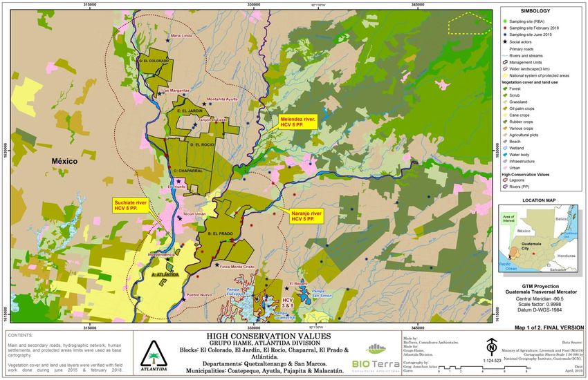
High Conservation Value Assessment - HCV
                 Existing Farms

                             Prepared for:

                           ATLANTIDA S.A.

                               Location:

Municipalities: Ayutla, Pajapita, Coatepeque, Malacatan and Retalhuleu.
     Departments: San Marcos, Quetzaltenango and Retalhuleu.
                           Country: Guatemala

                             Prepared by:

                        Name of the Assessor:

                    M.Sc. DARIÉN ZÚÑIGA LEITÓN

                            Delivery date:

                           November 2018

                                                                          2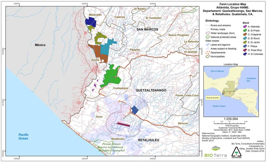
PUBLIC SUMMARY

DATE                   November 2018

NAME OF THE HCV
                       DARIÉN ZÚÑIGA LEITÓN
ASSESSOR
                       Empresa Soluciones Ambientales Bio Terra S.A.
                       Guadalupe, San José - Costa Rica
CONTACT INFORMATION
                       darzunle@gmail.com
                       (506) 8847-1336

CONSULTANT'S LICENSE   ALS14005DZ

TYPE OF LICENSE        Permanent

COMPANY REQUESTING     Atlántida S.A
                       Fritz George Versluys Martinez
THE ASSESSMENT
                       fversluys@olmeca.com.gt
                       Department: San Marcos
                       Municipalities: Ayutla, Pajapita and Malacatan
LOCATION OF THE        Department: Quetzaltenango
ASSESSMENT             Municipality: Coatepeque
                       Department: Retalhuleu
                       Municipality: Retalhuleu

ASSESSMENT DATE        January 2015 - November 2018

EXTENSION OF THE       Total Area: 6327.79 ha
EVALUATION AREA        Planted Area: 6214.23
NUMBER OF HECTARES
                       510.86 ha of HCV management areas
DESIGNATED AS HCV
                       80.3 Linear km (water bodies)
MANAGEMENT AREAS
                       The properties in this region are located entirely on land with
                       agricultural use. The adjoining farms also have land uses such as:
CURRENT LAND USE
                       other oil palm crops, pastures, sugarcane crops, agricultural plots
                       and scrubland.

CERTIFICATION METHOD   RSPO

                                                                                             3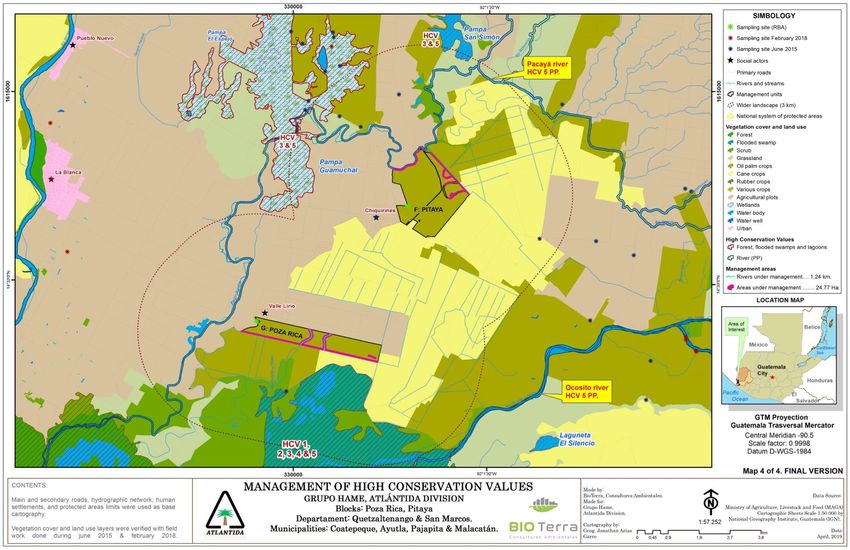
Table of Contents
1.          Introduction ........................................................................................................ 6
     1.1.      Dates of the assessment procedure ............................................................................ 6
     1.2.      Reference documents used ........................................................................................ 7
     1.3.      Project Status ............................................................................................................ 7
     1.4.      Company Information ................................................................................................ 8
     1.5.      Description of the assessment area ............................................................................ 8
     1.6.      Technical team that participated in the Assessment.................................................. 11

2.          Methodology .................................................................................................... 12
     2.1.      General Methodology (Organization chart) ............................................................... 15
     2.2.      Methodology for identifying High Conservation Values (HCVs) .................................. 16

3.          Results .............................................................................................................. 18
     3.1.      Regional context ...................................................................................................... 18
     3.2.      Landscape context ................................................................................................... 19
       3.2.1.        GEOLOGY .................................................................................................................................. 19
       3.2.2.        SOILS ........................................................................................................................................ 19
       3.2.3.        HISTORICAL LAND USE .................................................................................................................. 19
       3.2.4.        CLIMATE.................................................................................................................................... 20
       3.2.5.        HYDROLOGY ............................................................................................................................... 20
       3.2.6.        EROSION RISK............................................................................................................................. 21
       3.2.7.        BIOLOGY.................................................................................................................................... 21
       3.2.8.        PROTECTED AREAS, WETLANDS OR SITES OF CONSERVATION INTEREST .................................................... 22
       3.2.9.        POPULATION .............................................................................................................................. 23
       3.2.10.       ECONOMIC AND PRODUCTIVE ACTIVITIES .......................................................................................... 25
       3.2.11.       CULTURAL AND SOCIAL VALUES ...................................................................................................... 25

     3.3.      HCV Results ............................................................................................................. 26
     3.4.      Public consultation .................................................................................................. 31
       3.4.1.        ANALYSIS OF HCVS FROM WORK WITH STAKEHOLDERS ....................................................................... 33

4.          HCV Management and Monitoring .................................................................... 37
     4.1.      Threat Assessment ................................................................................................... 38
     4.2.      Management and Monitoring .................................................................................. 43

5.          References ........................................................................................................ 63
6.          Internal responsibility........................................................................................ 68

                                                                                                                                                                    4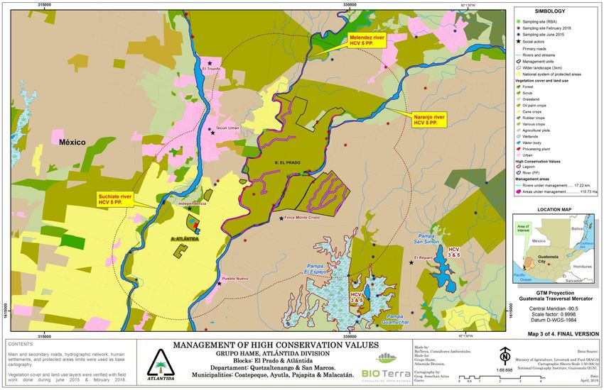
LIST OF ACRONYMS

  ACRONYM                                          MEANING
    AICA    Important Bird Areas
     ANP    Natural Protected Area
     HCV    High Conservation Value
    CITES   Convention on International Trade in Endangered Species of Wild Fauna and Flora
    COG     Coordinator of Guatemalan Communities for the Defense of Mangroves and Life
 Mangrove
   CONAP    National Council of Protected Areas
  CONRED    National Plan for Disaster Risk Reduction
     DD     Insufficient Data
     EER    Rapid Ecological Assessment
     FSC    Forest Stewardship Council
     GPS    Global Positioning System
     HCV    High Conservation Value
   IARNA    Institute of Agriculture, Natural Resources and Environment
     IBA    Important Birds Areas
     ICC    Private Institute for Climate Change
    INAB    National Forest Institute
INSIVUMEH   National Institute of Seismology, Volcanology, Meteorology and Hydrology
      LC    Least Concern
     LEA    List of Endangered Species
   MAGA     Ministry of Agriculture, Livestock and Food
   MARN     Ministry of Environment and Natural Resources
 MINEDUC    Ministry of Education
   MIDES    Ministry of Social Development
     NA     Not Applicable
     NPP    New Planting Procedure
    ONG     Non-Governmental Organization
      PE    Endangered
  PLAMAR    Risk Master Plan
      PN    National Park
     PNP    New Planting Procedure
      PP    Precautionary Principle
     RAP    Rare, Threatened and Endangered Species
     REA    Rapid Ecological Assessment
   RENAP    National Registry of Persons
    RSPO    Roundtable on Sustainable Palm Oil
      SA    Public Limited Company
 SEGEPLAN   Secretariat of Planning and Programming of the Presidency
      SI    Smithsonian Institute
     SIG    Geographic Information System
     SPG    Global Positioning System
     UM     Management Unit
    UICN    International Union for Conservation of Nature
  UNESCO    The United Nations Educational and Cultural Organization
     VES    Visual Encounter Surveys
    WWF     World Wildlife Fund

                                                                                              5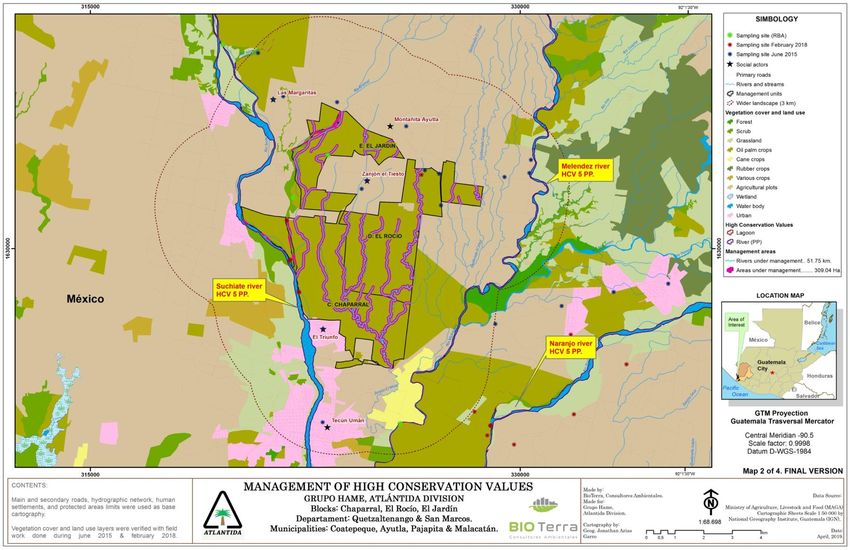
1. INTRODUCTION

The details of the dates on which this HCV assessment was carried out are presented below.

1.1. DATES OF THE ASSESSMENT PROCEDURE

                               TABLE 1. DATES OF THE ASSESSMENT PROCEDURE.
                                     AGENDA OF ACTIVITIES CARRIED OUT
                                              JANUARY 2015
 •    Initial contact is established between the Company and Bio Terra, and negotiations begin to
      perform an HCV assessment of their farms.
 •    The requested offer is sent to the company.
 •    The Company sends first information on its farms and operations.
                                                APRIL 2015
 •    The negotiation of the Project resumes, the contract is reviewed by both parties and is signed.
 •    Bio Terra provides guidelines for the work required for performing the Rapid Ecological
      Assessment (REA) by the counterpart in Guatemala.

                                                MAY 2015
 •    Coordination for performing REA field work with the consultant begins in Guatemala.
 •    The Company begins by sending the information of the farms under study, and of the
      stakeholders of the area of influence.
 •    Field work coordination begins by Bio Terra.
 •    Bio Terra carries out an analysis of the location of the Project at a regional and local level.
 •    Bio Terra sends the company the control points that will be checked in the field.

                                               JUNE 2015
 •    The field work for the REA is carried out by the consultant in Guatemala.
 •    The draft work schedule is created by Bio Terra.
 •    The field work is carried out by Bio Terra:
      ❖ General study area recognition by Bio Terra.
      ❖ Review of the company's documentation.
      ❖ Meetings with stakeholders.
                                      JULY 2015 - DECEMBER 2015
 •    Bio Terra requests the requiered information from the Company to carry out the HCV
      Assessment.
 •    The Company begins by sending the requested information.
 •    Bio Terra reviews the information provided by the Company.
 •    A bibliographic review of existing information for the area is carried out.
 •    The HCV Assessment creation begins.
 •    Creation of HCV Assessment maps begins.
                                          YEARS 2016 -2017
 •    The HCV Assessment was stopped for lack of information on behalf of the Company because
      of internal issues.

                                                                                                        6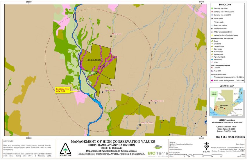
JANUARY 2018
 •    The HCV Assessment is resumed
 •    The Company sends part of the information necessary for Bio Terra to continue with the HCV
      Assessment.
 •    The HCV Assessment creation continues.
 •    Creation of HCV Assessment maps continues.
                                          FEBRUARY 2018
 •    A new fieldwork is being carried out by Bio Terra to update data, validate information that
      had been generated, and carry outh the final consulting with stakeholders on the HCVs
      identified and the proposed management and monitoring measures.
 •    The HCV Assessment creation continues.
 •    Creation of HCV Assessment maps continues.
                                     MARCH - SEPTEMBER 2018
 •    The HCV Assessment creation continues.
 •    The HCV maps are refined, based on the contributions of the stakeholders in the last field
      work carried out.
                                         OCTOBER 2018
 •    The Company sends the final information required.
 •    The first draft of the HCV assessment is completed.
 •    The first drafts of the HCV maps are completed.
                                          NOVEMBER 2018
 •    The final HCV Assessment is delivered.

1.2. REFERENCE DOCUMENTS USED

Below are the main reference documents used for preparing this HCV assessment:

a)   HCV Assessment Manual (HCV Resource Network, September 2014)
b)   HCV Assessment Report Template (HCV Resource Network, June 2015)
c)   Template for Public Summaries of HCV Assessment Reports (HCV Resource Network, June 2015)
d)   Common Guidance for HCV Identification (HCV Resource Network, September 2017).
e)   Common Guidance for HCV Management and Monitoring (HCV Resource Network, April 2018).

1.3. PROJECT STATUS

The project in question pertains to existing palm oil plantations which belong to Atlántida S.A.,
located in predominantly agricultural areas.

The scope of the evaluated area includes 7 plantations covering a total area of 6327.79 ha, of which
the planted area is 6214.23 ha.

                                                                                                    7
1.4. COMPANY INFORMATION
Atlántida S.A. is a company dedicated to the production of crude palm oil -CPO-, located at kilometer
260.5 on the road to the municipality of Ocos, San Marcos. It was established in 1989, and its
production has been mainly destined to satisfy the needs of the domestic and international markets,
supplying raw materials to refineries for producing fats and oils. It consists of 7 administrative blocks
located between the departments of San Marcos and Quetzaltenango.
The land use in the different blocks prior to the establishment of palm crops was agricultural, such
as cotton, sugarcane, basic grains, and livestock, among others.
The Company's annual productivity is 207,904 MT of fresh oil palm fruit bunches. They work with
their own production and that of independent producers (Inversiones Tropicales de Guatemala: El
Retiro, La Palmita, El Naranjo III, Vegas Alamo farms) with a total of 1595.6 hectares.
In terms of employees, the Company has 1,750 employees in the field and 150 in plant.
In relation to the management of good environmental practices, the Company has the following
guidelines: reforestation programs, responsible waste management, prohibition of hunting and
fishing, and generation of clean energy through the use of by-products from the extraction plant,
among others.
The Company is also Rainforest Alliance certified for its plantations and HACCP certified for its
processing and is in the process of becoming RSPO certified.
Atlantica's growth expectation is relatively low, and they are focused on maintaining the plantations
that have been established so far and improving production rates per unit area, per year.
Below is the Company's contact information:
TABLE 2. COMPANY CONTACT INFORMATION
NAME OF THE COMPANY: Atlántida S.A.
PERSON RESPONSIBLE FOR
Fritz George Versluys Martinez
CERTIFICATION
EMAIL ADDRESS fversluys@olmeca.com.gt
TELEPHONE NUMBER 24295555 Ext 1450
1.5. DESCRIPTION OF THE ASSESSMENT AREA
The farms under study are located in the departments of San Marcos, Quetzaltenango and
Retalhuleu, within the municipalities of Ayutla, Pajapita, Coatepeque, Retalhuleu and Malacatan, in
Guatemala.
The table below shows the farms assessed, their total area, planted area, location, planting date and
status:
8TABLE 3. LOCATION AND AREA OF THE FARMS.
Condition
Total Planted
No. Farm Sowing date Municipality Department (owned
Area Area
or leased)
1988, 1989,
2006, 2010,
Company
1 Atlántida 68.35 68.35 2011 Ayutla San Marcos
owned
Renewals
2010 and 2011
Owned
2004, 2005,
2 El Prado 1,996.17 1,952.16 Pajapita San Marcos and
2010, 2011
leased
1990, 1991,
Company
3 Chaparral 1,189.31 1,161.79 1996, 2010, Ayutla San Marcos
owned
2011, 2013
1992, 1996
Company
4 El Rocio 1,088.81 1,070.71 and renewals Ayutla San Marcos
owned
1992, 1996
Owned
5 El Jardín 819,02 807,79 2003, 2005 Ayutla San Marcos and
leased
Owned
6 Pitaya 329,67 319,33 1997, 1998 Coatepeque Quetzaltenango and
leased
Company
7 Poza Rica 188,01 186,52 1994 Retalhuleu Retalhuleu
owned
El 2003, 2009,
8 648,45 647,39 Malacatán San Marcos Leased
Colorado 2011
TOTAL 6327.79 6214.23
The proposed Project is considered to be of low scale and intensity, if we take into account that the
plantations cover 6214,23 ha distributed in 7 blocks, located in 5 Municipalities and 3 Departments.
In terms of sites or ecosystems, the studied areas do not contain ecosystems or habitats
representative of this region, since most of them are areas completely occupied by oil palm.
The study area is located in a rural area, where agriculture and livestock are the driving force of the
local economy.
9FIGURE 1. FARM LOCATION MAP.
101.6. TECHNICAL TEAM THAT PARTICIPATED IN THE ASSESSMENT
The technical team that participated in the development of this HCV Assessment is presented below:
TABLE 4. TECHNICAL TEAM THAT PARTICIPATED IN THE ASSESSMENT.
NAME LICENSE INSTITUTION POSITION SPECIALTY
Biologist specialized on sustainable
development ecology, Master in Audits
and Environmental Management
specialized in integral water
management and contaminated soil
MSC. Bio Terra Head
ALS14005DZ recovery. Experience in flora and fauna
DARIÉN Environmental Consultant
Complete taxonomy Extensive experience in
ZÚÑIGA L. Consultants Biologist
ecological assessments and analysis of
water bodies using biological indicators.
Participated in over 35 HCV studies
throughout Central America and
Mexico.
Professional in Biological Sciences with
emphasis in ecology in sustainable
development, Master in Audits and
Environmental Management with
MSC.
Bio Terra specialization in management and
MARISOL ALS14004MZ
Environmental HCV Biologist conservation of natural areas and
ZUMBADO Complete
Consultants marine pollution. Specialist in
B.
Environmental Management Studies
and Plans. Extensive experience in HCV
studies with over 35 studies conducted
in Central America and Mexico.
Geographical sciences specialized in
Land Management. Knowledge in
LIC. Environmental Management and Audits
Bio Terra
JONATHAN Geographer - in Environmental Engineering and
NA Environmental
ARIAS GIS Technology. Experience in Urban
Consultants
GARRO Ecology and Interurban Biological
Corridors. Extensive performance in
thematic mapping and spatial analysis.
Master's Degree in Housing and Social
MSC.
Bio Terra Equipment. Specialist in design,
CYNTHIA
NA Environmental Sociologist organization and implementation of
ROSALES
Consultants participative processes for diverse study
CALVO
designs.
Doctor in Environmental Law. More
than 30 years of professional practice.
PH.D ROSA Bio Terra Director of the Talamanca Caribe
Environmental
BUSTILLOS NA Environmental Biological Corridor for 20 years,
Law
L. Consultants consultant for the National Forestry
Financing Fund (FONAFIFO) for 10
years, and Environmental Consultant
11NAME LICENSE INSTITUTION POSITION SPECIALTY
for Conservation and Natural Resource
Management Projects.
Biologist in Biologist with extensive experience in
JOSÉ LUIS
charge of the REA, and HCV assessments.
LÓPEZ
REA
2. METHODOLOGY
This report was developed following a series of methodological procedures, which allowed to
produce the data that reflect the current status most accurately.
Rapid Ecological Assessment (EER)
The methodological process involved carrying out a Rapid Ecological Assessment (REA), which is a
systematic and articulated methodology that quickly provides the information needed for decision
making related to the conservation of biodiversity (Sayre et al., 2000). It is also used to quickly
determine the structure of the landscape, community and habitat and to integrate multiple levels
of information, where the most outstanding is the field work, focused on groups of organisms that
allow us to obtain some knowledge of the biological diversity of the area (Sobrevilla & Bath, 1992).
Precisely, in order to know the diversity of the sampling area, a process was followed to obtain data,
which was based on the main groups of flora and fauna (mammals, reptiles and birds). For this
purpose, we had the support of biologist José Luis López, who was the counterpart for this project
in Guatemala and who made the preliminary visit. In addition to collecting all environmental
information, the consulting company Bio Terra, also conducted a field visit to the farms, in order to
verify the data obtained from a random sampling and feedback the data obtained. For more detail
on this methodology see annexes 11.1.1, 11.1.2 and 11.1.3. of the complete assessment.
Social consultation
On this subject, it should be clarified that we worked with all the communities present within the
broader landscape analyzed on the Guatemalan side, which is where the farms are located, and
which had been previously identified (María Linda, Las Margaritas, Montañita Ayutla, Zanjón el
Tiesto, El Triunfo, Tecún Umán, Independencia, Finca Monte Cristo, Pueblo Nuevo, Valle Lirio and
Chiquirines).
Likewise, a process of consultation and gathering information was carried out within the
communities and with key stakeholders, to reinforce information on the absence or presence of
HCVs in the area, hand in hand with existing information. This consultation and interview process
was carried out by a professional team with experience in the social field. In this process, focus
groups were mainly used, and some structured and semi-structured interviews were used.
The field work in general, was carried out in 3 stages:
12TABLE 5. STAKEHOLDER CONSULTATION PROCESS.
Date Detail Observation
Preliminary visit made by The first approach was made with the Company and
June
the team's biologist communities to carry out the REA.
2015
counterpart in Guatemala.
The field work was carried out by visiting the farms under
June analysis and their areas of influence.
Visit by the Bio Terra team.
2015 The consultation with stakeholders was carried out.
Thirteen people participated.
Some sites are visited again to corroborate and validate
certain information.
A new consultation is carried out with stakeholders where
February
Visit by the Bio Terra team. the information initially collected is updated, and the final
2018
consultation is carried out regarding the HCVs identified,
and the management and monitoring measures proposed.
Eighteen persons participated.
During the first visit, primary research was conducted, preliminary tours of the study area, a first
approach with stakeholders, and the collection and verification of information from the Company.
It is also used as an opportunity to carry out the EER.
Subsequently, during the field work, as part of the social consultation through focus groups,
participatory workshops are held in which space and materials (maps, among others) are provided
so that the same stakeholders can contribute to the location and identification of the HCVs present
in the ADI, protected areas, communities, etc.
For this social consultation we worked with various focus groups, which correspond to the
stakeholders of the different sectors of analysis. For both the focus group consultation and the
individual interviews that were conducted, the templates included in Annex 11.1.8 were used as a
basis. of the complete assessment.
It is important to mention that as part of the stakeholder consultation process, participatory
mapping is also carried out, where the stakeholder focus group being worked with is sub-divided
into smaller groups, so that each sub-group is made up of people from the same sector. The
objective is that each sub-group creates a sketch or map on large flip chart paper, where they
identify the main environmental and social elements of their communities, and then each group
presents its results, and these results are analyzed and discussed by the entire group. Evidence of
this process is presented in Annex 11.4. of the complete assessment.
Participatory mapping is done at the board level and not on the field, because logistical and legal
factors (such as access to private property, among others) make it impossible to tour the wider
landscape with stakeholders.
The isolated interviews mentioned above, correspond to some interviews that are conducted in the
field during the visits and sampling on the farms, with strategic people that the team meets during
the tour, in order to complement the information generated in the work with the focus groups.
It is important to mention that Bio Terra has already conducted other HCV assessments in the area,
so they have a good knowledge of the area and the HCVs there. This information is complemented
13with geospatial analysis, aerial photos, satellite images, coverage interpretation, etc., in order to
generate preliminary HCV maps. These preliminary HCV maps are generated before the field work
is carried out, and with them part of the work with the stakeholders is developed as indicated in
advance. Similarly, the issue is handled with management and monitoring measures, where first the
stakeholders present their concerns and recommendations, and then these are discussed based on
the information previously generated by Bio Terra. The above, as part of the Final Consultation
performed.
With the information gathered during this social consultation process, the advisory team carries out
a qualitative analysis, and complements it with research carried out through a bibliographic review
and information available in different public institutions such as The National Council for Protected
Areas (CONAP), National Council for Disaster Reduction (CONRED), Institute of Anthropology and
History of Guatemala (IDAEH), National Institute of Forests (INAB), Ministry of Environment and
Natural Resources (MARN), Ministry of Agriculture, Livestock and Food (MAGA), Secretariat of
Planning and Programming of the Presidency of the Republic of Guatemala (SEGEPLAN).
Bibliographic Review
Complementarily, a bibliographic review was carried out on the existing information on the area
under study, both at the level of formal scientific studies, and through informal consultation to
gather local knowledge, which would enrich the information obtained directly through the field
research process.
Annex 1 of the complete assessment includes specific details of the methodologies used for
developing this study. The detail of the sampling points is also included.
The latter were selected based on representativeness criteria of forest cover, ecosystems of interest
and natural elements that may be important for conservation. Due to the characteristics of the
southern coast and its history with the different extensive crops that began in the 1960s, forest
cover is very scarce. Currently these remnants hardly have connectivity with other natural areas or
form part of a representative forest mass for the life zone or the region. However, the criteria for
selecting the sampling points were maintained in order to corroborate and characterize the study
area. Some farms are completely occupied by oil palm, so the data collection was carried out in sites
bordering areas of interest (communities, drainage canals, rivers and other crops). Other criteria
include ecologically strategic sites that may be subject to impact from the palm oil production cycle
activities. Several farms border permanent or intermittent rivers, which can be considered
protection or conservation elements. (López, 2015).
Explanatory note: It is important to mention that the field work was carried out mainly in the sector
of the larger landscape located in Guatemala, and the information related to the larger landscape
located on the Mexican side was obtained through information collected at the council level, using
official information from the State of Chiapas and INEGI. This was due to internal logistic and security
issues that prevented them from crossing into Mexico (this border is an important route for migrants
and drug trafficking, which makes it a very dangerous border). This issue is identified as a limitation
of this evaluation.
Below is the map with the sampling sites for the assessment, and the map of the communities
consulted.
142.1. GENERAL METHODOLOGY (ORGANIZATION CHART)
METHODOLOGY
METHODOLOGICAL ASPECTS
Exchange of information with the Company.
Board Design and Planning • Analysis of aerial photos and satellite
images
• Preliminary consultation of
information with government
institutions.
Board Design and Planning / • The counterpart biologist makes the
Preliminary Visit preliminary visit and EER.
• Selection of sampling points.
SIG Preliminary
• Preliminary HCV maps are
Digitalizing
generated.
Field testing and
consultation with • Information verification field work
stakeholders (2015 and is carried out in the pre-selected
sampling sites.
2018)
• Group work is carried out. Focus
groups and interviews with
stakeholders are carried out. This
field work is being carried out in
two points in time 2015 and 2018
Consultation and Review of
(Final Consultation).
Existing Scientific Information
•
and the Ecological Assessment
conducted for this HCV
Assessment
Final Product
Identification of HCVs - Management and Monitoring
152.2. METHODOLOGY FOR IDENTIFYING HIGH CONSERVATION VALUES (HCVS)
TABLE 6. METHODOLOGY FOR IDENTIFYING HCVS.
HIGH CONSERVATION VALUES METHODOLOGICAL PROCESS
-SIG information
❖ Satellite and aerial image analysis.
❖ ASP maps, land use, etc.
❖ GFW analysis.
HCV1: Species diversity
-Secondary information
❖ Review of management plans of the ASP.
❖ Listings of NGOs.
❖ General bibliographic review.
❖ RAMSAR sites Guatemala.
❖ Important Bird Areas, America-Guatemala.
-Review of lists of species from national and international
agreements
-HCV2: Ecosystems and mosaics at a ❖ CITES.
landscape scale ❖ UICN.
❖ Guatemalan regulations.
❖ Others.
Rapid Ecological Assessment (REA)
-Collection of field information / Field sampling
❖ Daytime terrestrial fauna.
-HCV3: Rare, threatened or ❖ Daytime flying fauna.
endangered ecosystems and habitats ❖ Flora
-Consulting stakeholders through focus groups and/or individual
interviews.
-SIG information
❖ Soil and vegetation maps.
-HCV4: Ecosystem services ❖ Hydrological maps
❖ ASP Maps
❖ Cartographic sheets.
❖ Satellite and aerial image analysis.
-HCV5: Community needs -Secondary information
❖ Review of management plans of the ASP.
❖ Analysis of government databases.
❖ General bibliographic review.
-Consulting stakeholders through focus groups and/or individual
-HCV6: Cultural Values interviews.
UNESCO
16TABLE 7. CHRONOLOGY CARRIED OUT DURING THE EVALUATION.
Fieldwork by Bio
Coordination to Fieldwork by Analysis of the
Outreach visit is Terra and Generation of the
Date develop the HCV counterpart in Board Work information
made consultation with HCV Assessment
Assessment. Guatemala (EER) collected
stakeholders
Jan - May
15
Jun 15
Jul - Dec
15
2016 /
Evaluation stopped for 2 years by internal issues within the Company
2017
Jan 18
Feb 18
Mar - Aug
18
Sep - Nov
18
173. RESULTS
3.1. REGIONAL CONTEXT
The project is located in Region VI of Guatemala, the southwestern region, with a land area of
approximately 12,230.00 Km2, equivalent to 11% of the total national territory. Of these 1,951 km2
belong to Quetzaltenango; 1,856 km2 to Retalhuleu; 3,791 km2 to San Marcos. Access to region VI is
via paved roads in good condition. To the north is Departmental Highway 1, to the west and south
is the CA-2 highway and from Guatemala City the Interamerican CA-1 highway (REDFIA, 2003). Its
departments have future development plans.
This region has mostly rural population. According to their ethnic-linguistic characteristics, the
majority of the population is Mayan, although there is also a mestizo (ladino) population, especially
in urban areas and in the south of the region. The Mayan linguistic communities are: Mam,
Sipakapense, K'iche', Kaqchikel, and Tz'utujil (REDFIA, 2003).
Guatemala is a mountainous country, with a main mountain range that crosses the country from
northwest to southeast and extends throughout the Mexican state of Chiapas. In this mountain
range vast plateaus are formed to the northeast which form the highlands of Guatemala. Its highest
altitude is reached in the Sierra Madre.
Chuvieco (2002) indicates that Guatemala's biogeographic position (between the Nearctic and
Neotropical regions) and inter-oceanic position (between the Atlantic and Pacific oceans) make it
one of the most biodiverse countries in the world. Also, it is located within one of the priority
conservation areas, and according to Conservation International (CI) Mesoamerica is one of the
largest biodiversity hotspots in the world. The term hotspots refer to areas of high biodiversity
characterized by exceptional levels of endemism, and the region is also an important corridor for
several species of neotropical migratory birds.
As mentioned above, the region has warm subtropical humid forest and warm subtropical very
humid forest life zones. The first is 10 to 22 km wide, stretching from El Salvador to Mexico on the
Southern Coast. It also includes the northern part of the Department of El Petén which borders from
east to west with a line that goes from the north of Melchor de Mencos through El Remate, then
heads south until it reaches the border with Mexico. The total area of this life zone is 27,000 km 2,
which represents 24.81%, occupying the second place in extension of the total area of the country.
The second life zone is the largest in Guatemala, covering a strip of 40 to 50 km wide on the South
Coast from Mexico to Oratorio and Santa Maria Ixtahuatan (both municipalities in the department
of Santa Rosa). In the northern part of the country, it covers the departments of Izabal, northern
Alta Verapaz, Quiché and a part of Huehuetenango, as well as the southern part of Petén. The total
area is 40,700 km2, which represents 37.41% of the country's surface.
The region is home to the Manchón Guaumuchal Special Protection Area, which is the largest coastal
marine wetland on the Pacific Coast of Guatemala (CONAP, 2019). It is characterized by a
combination of different plant communities, including coastal dune flora, dry forest, mangrove
forest, palm forest, aquatic macrophytes, willow forests, freshwater and brackish water lagoons,
marsh areas and freshwater wetlands and areas with secondary vegetation. They are influenced by
tides and river floods, with a water level variation of no more than 2 meters.
18The system is separated from the sea by three sand bars about 100 m wide. It has dry subtropical
forest to the south and warm subtropical rainforest to the north. The swamp zone is characterized
by areas of emergent vegetation dominated by grasses and sedges, with some trees and shrubs on
high promontories. The coastal lagoons present have depths between 1 and 3 meters. The wetland
may be one of the last sites in Guatemala for migratory birds and for important breeding grounds
for marine invertebrates and fish, many of which are commercially important. Human activities
include shrimp farming, agriculture and livestock. The floodable area covers a total of over 25,000
hectares, of which 7,650 hectares are covered by mangroves. The proposed protected area is 13,942
hectares, of which 1,242 hectares are part of a private nature reserve designated in 1998 for
conservation, ecotourism, and recovery. The area is surrounded by private farms.
On the other hand, it is important to mention that part of the larger landscape of the farms is located
in the state of Chiapas in Mexico. According to the Chiapas State Development Plan (2019-2024),
the state has an area of 74,415 km2which corresponds to 3.8% of the national territory. It is bordered
to the east and south by the Republic of Guatemala, through a 658.5 km border strip that is
equivalent to 57.3% of the country's southern border and includes 18 municipalities and
approximately 22,417 towns, mostly rural. There are at least 32,868 Guatemalan temporary
immigrants that work for the agricultural industry in this state.
3.2. LANDSCAPE CONTEXT
3.2.1. GEOLOGY
The main geological unit present in the wider landscape are alluvium or recent sedimentary
deposits, product of weathering and subsequent transportation by the different surface drainage
networks that exist within or on the periphery of the farms, so there is debris of different sizes and
eventually some boulders associated with the main drainages that cut the farms under study. The
main deposits identified consist of boulders and gravels, sand and gravel and silty-clay floodplain
sediments.
The geological conformation in both the Guatemalan and Mexican sectors is described as
Quaternary sedimentary rock, formed by the dragging of sediments from the volcanic belt of the
country by means of runoff through the hydrographic network that covers the southern coast.
3.2.2. SOILS
A large portion is formed by the following types of soils: sea beach area, Bacul (formed by marine
or alluvial deposits and the height of these soils ranges from 0 meters to 90 meters above sea level).
According to the official databases from INEGI for Mexico and IGN for Guatemala, the predominant
soils in the broader landscape can also be classified as Cambisols, Fluviosols, Phaeozem+Cambisols,
Entisols, Alfisols, Mollisols and Vertisols.
3.2.3. HISTORICAL LAND USE
The extensive use that has been made of the lands where the farms are located, as well as in the
greater part of the southern coast of Guatemala, was the result of the agrarian reform or better
known as Decree 900, which sought, among other things, to eradicate feudal property and to force
19the transfer of farms or unused lands to the peasants so that they could be worked. (Kwei, 2018).
In the 50's and 60's there was a cotton cultivation boom in the region, and consequently there was
a land conversion from forests to this crop. Years later, other monocultures such as sugar cane, oil
palm, bananas, among others, were planted. Currently the main use of soil is residential, sugar cane
plantations, agroforestry systems and palm, banana and plantain plantations.
The properties are located on agricultural land, where several annual and perennial crops are grown,
as well as pastures for livestock and rangeland. It was determined that there are very few forest
remnants, which are not representative. The predominant crops in this area are rubber, plantain,
banana and oil palm.
In the current development plans (2011-2025) of the municipalities in the wider landscape, it is
stated that the main problem is deficient management and regulation of land use, so it is proposed
to take actions at the municipal level to achieve adequate environmental management and
achieving sustainable development of these municipalities.
The above is very similar to the broader landscape located in Mexico, after an analysis of the land
use maps available in INEGI dated 1984, 1997, 2003, 2010 and 2013, since 1984 the predominant
land use was already agricultural and livestock, with remaining sectors of grasslands, which over
time have also changed to agricultural and livestock uses.
3.2.4. CLIMATE
The study area is located in the Pacific Coastal Plain, a warm zone with an average temperature of
26.9°C and an average precipitation of 1684.71mm between the years 2000 and 2016. Below is the
average climate behavior of the area:
• Room temperature 25.5 - 28 C
• Pressure 1000 - 1015 mBar
• Relative humidity 67 - 75%
• Precipitation 800 - 1900 mm
• Evapotranspiration 1800 - 2200 mm
• Wind speed 22 - 24 Km/h
3.2.5. HYDROLOGY
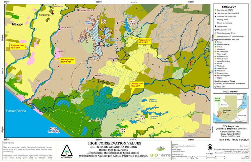
The farms are located within the Suchiate, Naranjo and Ocosito river basins. El Colorado farms are
located within the Suchiate river basin. The rivers that flow through the AP are the Suchiate, Ixben
and El Zapote creek. Like the previous farm, the El Jardín is within the Suchiate River basin, which is
crossed by the Cabuz River, Tecomate, Zanjón El Marinbeado, Zanjón El Mico.
The Suchiate River in this sector is the border between Guatemala and Mexico; within the broader
landscape located on Mexican soil, there are no records of primary rivers or important tributaries
to the Suchiate River.
The El Rocío farm is located within the Navarro river basin, which is crossed by the tributaries of the
Zanjón El Tieso, Zanjón San Lorenzo, La Burra creek and some small unnamed streams.
20The Chaparral farm is located between the Suchiate watershed to the northwest and the rest on the
Naranjo river basin. The bodies of water that cross the farm are the Suchiate river, Cabuz river, some
tributaries of the Zanjón El Marinbeado river, Zanjón El Mico river, the Motas creek and some minor
streams.
El Prado farm is located within the Ocosito watershed to the southeast and the Naranjo watershed
to the west and is affected by three bodies of water: the Chisna, Meléndrez and Zanjón El Tieso
rivers.
The Pitaya farms are located within the Ocosito watershed, and the northernmost farm is bordered
to the north by the Zanjón Pacaya.
Finally, the Atlántida farms are located within the Suchiate watershed and are not affected by any
of the above bodies of water.
3.2.6. EROSION RISK
The main causes of erosion of the area are related to deforestation, inadequate practices of annual
crops, non-implementation of soil conservation techniques, erosion potential of some soil types,
and lack of protection of riverbanks.
However, its proximity to the sea and flat topography creates a rather low hydraulic gradient that
indirectly reduces the risk of erosion.
3.2.7. BIOLOGY
Life Zones
Palm plantations are located in life zones defined as warm subtropical very humid forest (bmh-Sc)
and warm subtropical humid forest (Bh-Sc).
The bh-S(c) life zone is a segment of the humid subtropical. It is located in the lower zone which, to
differentiate it from the upper zone, is designated by the letter "c" where the biotemperature is
above 30°C. The natural vegetation indicator in this area consists mainly of nance
(Byrsonimacrassifolia), chaparro (Curatella americana), malagueta (Xylopia frutescens), poppy
(Bombax ellipticum), black chechen (Metopium brownei) and oak (Quercus oleamides).
Depending on the life zone system, in bmh-S(c) the average annual biotemperature ranges from 21
to 25 degrees Celsius (°C). The natural vegetation consists mainly of the species: Scheelea preussii,
Terminalia oblonga, Enterolobium cyclocarpum, Sickingia salvadorensis, Triplaris melaenodendrum,
Cybistax donnell-smithii, Andira inermis (De la Cruz 1982).
Biological Overview
As mentioned, the southern coast of the country was highly impacted by extensive crop and
livestock activities in the 20th century, including the use of agrochemicals, which was a factor in the
degradation of soils and especially the environment. Thus, extensive forests or natural systems that
are significant for biodiversity are rare.
21To the south of the farms on the coast is the mangrove forest, which is one of the most important
natural resources of the Pacific coast of Guatemala for multiple ecological, economic and social
reasons. Ecologically, the mangrove fulfills functions such as protecting the coastal strip by serving
as a natural barrier to mitigate the action of waves and as a sediment fixer; it is also a recycler of
organic matter; it helps to reduce evaporation due to the shade it provides and offers shelter to
wildlife both on land and at sea.
The farms are located within the Humid Forest Eco-region of the Sierra Madre de Chiapas. The eco-
region includes broadleaf, humid, tropical and subtropical forests in volcanic highlands, Pacific
coastal plain lands, and volcanic piedmont lands. It is considered one of the most biodiverse
ecoregions on Earth. This ecoregion in Guatemala covers an area of 5,680 km² (FIPA-USAID 2002).
According to Villar's biome classification, the area is located in the Humid Tropical Savanna biome.
This biome ranges from 0 to 500 meters above sea level. Until the beginning of the 20th century it
was a closed jungle, apparently of Amazonian influence like that of the Caribbean Lowlands, but due
to the replacement of the original forests by agrosystems, the ecological complex was transformed
into a typical savannah. The fundamental ecosystems present in this biome are: savannas,
grasslands, medium deciduous forests, sublittoral thorny forests, sub evergreen forests, riparian
forests, reedbeds, estuaries, mangroves and coastal dunes. The predominant landscape in this
biome is composed of exotic grasses and trees such as palo blanco (Cybistaxdonell-smithii),
conacaste (Enterolobium cyclocarpum), pito (Erythrina standleyana), ceiba (Ceiba pentandra),
guayacán (Guaiacum sanctum), palo de hormigo (Platymiscium dimorphandrum) and corozo palm
(Orbignya cohune), among others. (Villar 1994; 1997; 2008).
3.2.8. PROTECTED AREAS, WETLANDS OR SITES OF CONSERVATION INTEREST
Protected Areas
According to the Guatemalan System of Protected Areas (SIGAP), the wider landscape is not located
within any protected area or special protection area, nor is there any connection thereof.
However, just 5.6 km from Block G (Poza Rica) is the Manchón Guamuchal Special Protection Area
(APEMG), declared under Legislative Decree No. 4-89 (internally registered as La Chorrera-Manchón
Guamuchal Private Natural Reserve by CONAP Resolution 107/98) (RedParques, 2012).
On the Mexican side, no nearby protected areas have been identified.
RAMSAR Sites
Within the greater landscape there are no RAMSAR sites. However, the Manchón Guamuchal
Special Protection Area (APEMG), which is located near the Project area, was included in the List of
Wetlands of International Importance, registered as Ramsar Site No. 725 in 1993.
This ecosystem is of great importance as a migratory corridor and for species restricted to specific
biomes and ranges in the area. However, it is located 5.6 km from Block G (Poza Rica) as indicated
above. It is mentioned here because part of the broader landscape of this block affects ecosystems
associated with Manchón Guamuchal.
22Important Bird Areas (IBA)
Within the wider landscape there are no AICA sites. However, according to Bird Life Organization
databases, nearby is Manchón Guamuchal, which is considered an AICA site (IBA GT025) and is also
categorized as a special protection area.
3.2.9. POPULATION
The following information on the population within the broader landscape is official information
obtained through the National Census XII conducted by INE. It is presented at the municipal level
since there was no access to official information at the community level; however, it is considered
to be representative of what was observed during the field work. The municipalities of Coatepeque,
Retalhuleu, Pajapita, Malacatán and Ayutla have development plans prepared with SEGEPLAN for
2010 and 2025.
The municipality of Retalhuleu has 90,505 inhabitants, of which 48% are men and 52% are women;
100% live in urban areas. 2.7% of the population is from the Mayan community, the predominant
linguistic community is K'iche'.
There are 21293 homes, 69% of which are homeowners and 17% rent; 46% have an internal pipeline
with a connection to the public service and 48% have a drilled well; the remaining percentage
obtains water from other sources. Ninety-five percent have electricity for lighting, 50% cook with
propane gas and 48% with firewood.
The municipality of Coatepeque has 105,415 inhabitants, of which 48% are men and 52% are
women, 65% live in rural areas and 35% in urban areas. 2.25% of the population is from the Mayan
community, the predominant linguistic community is K'iche'.
There are 23422 homes, 73% of which are homeowners and 16% rent; 65% have an internal pipeline
with a connection to the public service and 38% have a drilled well; the remaining percentage
obtains water from other sources. Ninety-four percent have electricity for lighting, 46% cook with
propane gas and 53% with firewood.
The municipality of Pajapita has 21,725 inhabitants of which 48% are men and 52% are women, 46%
live in rural areas and 54% in urban areas. The 0.6% of the population is from the Mayan community.
The predominant linguistic communities are Chalchiteka and K'iche'.
There are 4723 homes, of which 75% are homeowners, 14% borrow, and 10% rent; 55% have an
internal pipeline with connection to the public service and 33% have a drilled well; the remaining
percentage obtains water from other sources. Ninety-four percent have electricity for lighting, 40%
cook with propane gas and 59% with firewood.
The municipality of Malacatán has 92,816 inhabitants of which 49% are men and 51% are women,
91% live in rural areas and 9% in urban areas. 4.5% of the population is from the Mayan community,
the predominant linguistic community is the Mam.
23There are 18,307 homes, of which 91% are homeowners, 4% borrow and 5% rent; 39% have internal
piping with connection to the public service and 40% have a drilled well; the remaining percentage
obtains water from other sources. Ninety-five percent have electricity for lighting, 25% cook with
propane gas and 74% with firewood.
The municipality of Ayutla has 37,049 inhabitants of which 49% are men and 51% are women, 36%
live in rural areas and 64% in urban areas. 1.77% of the population is from the Mayan community,
the predominant linguistic community is K'iche'.
There are 8,685 homes, of which 74% are homeowners, 10% borrowed or rented and 15% rent; 52%
have an internal pipeline with connection to the public service and 43% have a drilled well; the
remaining percentage obtains water from other sources. Ninety-eight percent have electricity for
lighting, 63% cook with propane gas and 36% with firewood.
The municipality of Ocós has 10,841 inhabitants of which 49% are men and 51% are women, 59%
live in rural areas and 41% in urban areas. 0.7% of the population is from the Mayan community,
the predominant linguistic community is K'iche'.
There are 2573 homes, 83% of which are homeowners, 10% borrow and 8% rent; 28% have internal
or external piping with connection to the public service and 43% have a drilled well; the remaining
percentage obtains water from other sources. Ninety-eight percent have electricity for lighting, 44%
cook with propane gas and 54% with firewood.
The main communities in the broader Guatemalan landscape are: Maria Linda, Las Margaritas,
Montañita Ayutla, Zanjón el Tiesto, El Triunfo, Tecún Umán, Independencia, Finca Monte Cristo,
Pueblo Nuevo, Valle Lirio and Chiquirines.
Chiapas
The following information on the population within the broader landscape is official information
obtained through the Sociodemographic Panorama of Chiapas by INEGI, 49% of its population is
urban and 51% rural. It is presented at the municipal level since there was no access to official
information at the community level; these municipalities are part of the state of Chiapas located in
the south of the country.
The municipality of Suchiate has 38,797 inhabitants, of which 48.8% are men and 51.2% are women.
There are 9,891 homes, of which 57% own their homes, 17% borrow and 19% rent; 42% have
internal or external piping with connection to public services and 97% have electricity.
The municipality of Suchiapa has 24,049 inhabitants, of which 49.7% are men and 50.3% are women;
it has 5,632 homes, of which 74.7% own their own home, 7.4% borrow and 16.5% rent; 32.1% have
internal or external piping with connection to public services and 98.7% have electricity.
The municipality of Tuxtla Chico has 38,797 inhabitants, of which 48.3% are men and 51.7% are
women; it has 10,319 homes, of which 76.3% own their homes, 14.4% borrow and 6.3% rent; 55.7%
have internal or external piping with connection to public services and 98.4% have electricity.
24The municipality of Metapa has 5,743 inhabitants, of which 48.1% are men and 51.9% are women.
There are 5,743 homes, of which 71.1% own their homes, 15.3% borrowed or rented and 9.2% rent;
57.4% have internal or external piping with connection to public services and 98.7% have electricity.
The municipality of Frontera Hidalgo has 14,416 inhabitants, of which 48.5% are men and 51.5% are
women. There are 3,541 households, of which 76.3% own their homes, 12% borrow and 6.8% rent;
44.8% have internal or external piping with connection to the public service and 97.5% have
electricity.
The main communities of the broader Mexican landscape are: Metapa, Frontera Hidalgo, Ignacio
Zaragoza, Ciudad Hidalgo, Jesus, Ignacio Lopez Rayon.
3.2.10. ECONOMIC AND PRODUCTIVE ACTIVITIES
The economy of the broader Mexican and Guatemalan landscape is based primarily on agricultural
production. Its main crops include cotton, sugar cane, rubber and oil palm.
Due to the existence of good land and the abundance of varieties of pasture, there is also a great
variety of cattle breeds, and therefore also companies that process good quality dairy products.
Among its industries are also sugar mills, coffee mills, ice and liquor factories, cement products, and
essential oil factories, etc.
3.2.11. CULTURAL AND SOCIAL VALUES
Guatemala is a country with ethnic, cultural and linguistic diversity. According to official data, 41
percent of the population identifies itself as indigenous, from the National Population Census XI and
VI on housing of 2002 of the National Institute of Statistics -INE. In the state of Chiapas in Mexico,
26% of the population has indigenous origin.
The following ethnic groups are present in the area: Tzeltales, Tzotzijes, Tojolabales, Poqomames
and K'iche'. However, the predominant language is Spanish, although some native communities still
speak K'iche'.
Notwithstanding the above, no important ceremonial or sacred sites were identified in the
landscape analyzed, nor were there any significant historical or archaeological vestiges identified as
such by UNESCO. However, there are some archaeological remains, such as those found in a greater
part of Guatemala, which need to be studied to determine their level of importance.
Below is a map of the farms, highlighting the main communities in their vicinity.
253.3. HCV RESULTS
TABLE 8. HCV DETAILS IN THE MANAGEMENT UNIT.
Precautionary
Present Absent
HCV DESCRIPTION OF THE HCV Principle Remarks
HCV 1 is identified within the Manchón Guamuchal wetland
and other mangroves, lagoons and lagoons along the coast. The
Concentrations of biological diversity
presence of this HCV within the farms under study is ruled out.
containing endemic or rare species,
1 threatened or endangered species, and which X
This site concentrates a great biological diversity of rare,
have significant importance on a global,
threatened and endangered species, and is also a biological
regional or national scale.
corridor for endemic and migratory species and is also an AICA
site.
HCV 2 is identified in the Manchón Guamuchal wetland but is
excluded from the farms under study. This is the largest coastal
Large ecosystems and ecosystem mosaics on
marine wetland on the southern Pacific coast of Guatemala and
a landscape scale and important on a global,
is one of the last that still retains these proportions. This
regional or national scale, and that contain
2 X ecosystem has 25,000 hectares of floodable area, of which 7,650
viable populations of the vast majority of
hectares are covered by mangroves, and the proposed protected
naturally occurring species under natural
area is 13,942 hectares. This extension is considered
patterns of distribution and abundance.
representative for the region and preserves viable populations
of the species present there.
HCV 3 is identified in the Manchon Guamuchal wetland, and
other mangroves, lagoons and lagoons on the coast, and others
at the continental level. Manchón Guamuchal is one of the last
remaining large coastal marine wetlands on the South Pacific
Rare, threatened or endangered ecosystems,
3 X coast of Guatemala, and is currently a highly threatened and
habitats or refuges
vulnerable area, along with other mangrove ecosystems,
lagoons and ponds on the coast and inland, due to the lack of a
strong legal protection designation. Notwithstanding the above,
this HCV is excluded from the farms under study.
26Precautionary
Present Absent
HCV DESCRIPTION OF THE HCV Principle Remarks
HCV 4 is identified in the Manchón Guamuchal wetland and
other mangrove ecosystems, lagoons and ponds along the
coast. The presence of this HCV within the farms under study is
ruled out.
Basic ecosystem services in critical situations,
The critical ecosystem services identified are:
4 such as protection of watersheds and erosion X
control of vulnerable soils and slopes, etc.
1. Areas that provide shelter to communities during extreme
weather events.
2. Important ecosystems such as fish nurseries, which are
also fundamental for the subsistence of the communities
that make a living from fishing.
HCV 5 is identified in the Manchón Guamuchal wetland, and
other mangroves, lagoons and lagoons on the coast, and
others at the continental level.
The HCV 5 identified are as follows:
1. In the rivers and ditches of the area: water for human
supply of the communities and their crops. (Under the
Sites and resources critical to meeting the
precautionary principle).
basic needs of local communities, indigenous
X (water 2. Mangroves, lagoons and ponds: Fishing as a means of
5 groups (for livelihood, health, nutrition, X
supply) subsistence, both through direct consumption and trade.
water, etc.), identified through dialogue with
3. Machón Guamuchal: Navigation as a means of
said communities or indigenous people.
transportation for the communities located inside
Manchón.
HCV5 in the area's water bodies is identified under the
precautionary principle, due to the absence of specific technical
and scientific information on the amount of water withdrawn
from the water bodies, as well as the demand from crops and
communities.
27You can also read