Birch Avenue: Schedule B Municipal Class Environmental Assessment - Project File Report - City of Hamilton
←
→
Page content transcription
If your browser does not render page correctly, please read the page content below
Birch Avenue: Schedule B Municipal
Class Environmental Assessment
Project File Report

Prepared for City of Hamilton
by IBI Group
In associated with ASI and LGL
January 28, 2020
IBI GROUP
BIRCH AVENUE: SCHEDULE B MUNICIPAL CLASS ENVIRONMENTAL ASSESSMENT
Prepared for City of Hamilton

              Document Control Page

                CLIENT:                City of Hamilton
                PROJECT NAME:          Birch Avenue Municipal Class Environmental Assessment
                REPORT TITLE:
                                       Birch Avenue: Schedule B Municipal Class Environmental
                                       Assessment
                IBI REFERENCE:         121767
                VERSION:               v3
                DIGITAL MASTER:
                                       121767_Hmtn_BirchEA\6.0_Technical\6.3_Tech-Reports\Project
                                       File Report
                ORIGINATOR:            Trevor Jenkins
                REVIEWER:              Scott Johnston
                AUTHORIZATION:         Bruce Mori
                CIRCULATION LIST:

                                       V1 – Issued December 4, 2019
                                       V2 – Issued December 31, 2019
                HISTORY:
                                       V3 – Issued January 10, 2020
                                       V4 – Issued January 28, 2020
                                       V4.1 – Issued January 28, 2020
                                       V4.2 – Issued January 28, 2020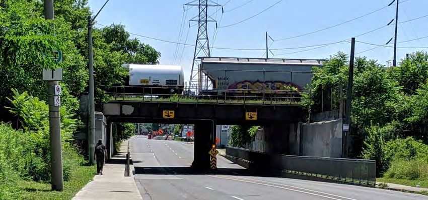
IBI GROUP
BIRCH AVENUE: SCHEDULE B MUNICIPAL CLASS ENVIRONMENTAL ASSESSMENT
Prepared for City of Hamilton

                   Table of Contents
                   1   Introduction ......................................................................................................................... 1
                       1.1         Study Area ............................................................................................................... 1
                       1.2         Study Context .......................................................................................................... 3
                       1.3         Municipal Class Environmental Assessment Process ............................................. 3
                       1.4         Study Organization and Project Team ..................................................................... 5

                   2   Relevant Policies and Studies ........................................................................................... 6
                       2.1         City of Hamilton Urban Official Plan ........................................................................ 6
                       2.2         Previous Drainage Studies ...................................................................................... 7
                       2.3         Transportation and Structural Studies ..................................................................... 7

                   3   Problem/Opportunity Statement ..................................................................................... 12
                       3.1         Need and Justification............................................................................................ 12
                       3.2         Problem and Opportunity Statement ..................................................................... 12

                   4   Existing Conditions .......................................................................................................... 13
                       4.1         Natural Environment .............................................................................................. 13
                       4.2         Social, Economic and Cultural Environments ........................................................ 14
                       4.3         Sewer System and Flooding Issues ...................................................................... 18
                       4.4         Transportation and Structural ................................................................................ 20

                   5   Active Transportation and Roadway Clearance ............................................................ 27
                       5.1         Active Transportation ............................................................................................. 27
                       5.2         Roadway Clearance............................................................................................... 31

                   6   Alterative Solutions and Evaluation Process (EA Phase 2) ......................................... 38
                       6.1         Alternatives Solutions: Pumping Station Locations ............................................... 38
                       6.2         Alternatives Solutions: Flow Reduction Measures Solutions................................. 39
                       6.3         Evaluation Process and Criteria ............................................................................ 42

                   7   Evaluation of Alternative Solutions ................................................................................ 43
                       7.1         Evaluation Results: Pumping Station Locations .................................................... 43
                       7.2         Evaluation Results: Flow Reduction Measures Solutions ..................................... 45

January 28, 2020                                                                                                                                             i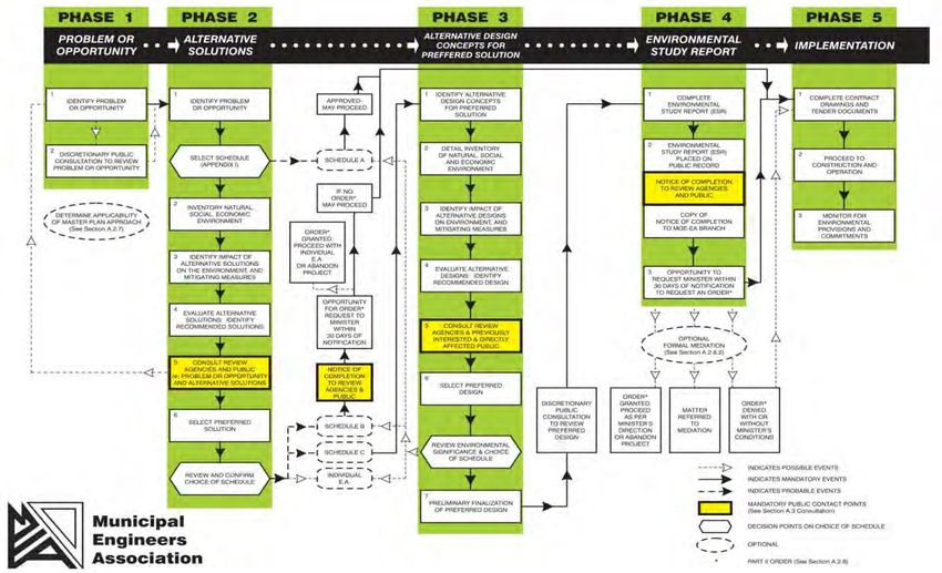
IBI GROUP
BIRCH AVENUE: SCHEDULE B MUNICIPAL CLASS ENVIRONMENTAL ASSESSMENT
Prepared for City of Hamilton

                   Table of Contents (continued)
                   8    Preferred Alternative Solution ......................................................................................... 48
                        8.1       Description of the Preferred Alternative ................................................................. 48
                        8.2       Approvals ............................................................................................................... 50

                   9    Impacts, Mitigation Measures and Commitments ......................................................... 52
                        9.1       Social and Economic ............................................................................................. 52
                        9.2       Cultural Environment ............................................................................................. 56
                        9.3       Natural Environment .............................................................................................. 57

                   10   Refinements for Detailed Design .................................................................................... 59
                        10.1      Active Transportation and Roadway Design ......................................................... 59
                        10.2      Roadway Clearance............................................................................................... 60

                   11   Consultation and Engagement ........................................................................................ 61
                        11.1      Engagement Approach .......................................................................................... 61
                        11.2      Notice of Study Commencement ........................................................................... 63
                        11.3      Indigenous Communities ....................................................................................... 63
                        11.4      Public Agencies, Utilities and Railways ................................................................. 63
                        11.5      Public and Community Consultation ...................................................................... 64

                   Appendix A: Design Drawings1

                   Appendix B: Natural Heritage2

                   Appendix C: Cultural Heritage and Archaeology3

                   Appendix D: Transportation Assessment and Cycling Facility Selection Analysis4

                   Appendix E: Drainage Assessment5

                   Appendix F: Consultation and Engagement6

January 28, 2020                                                                                                                                            ii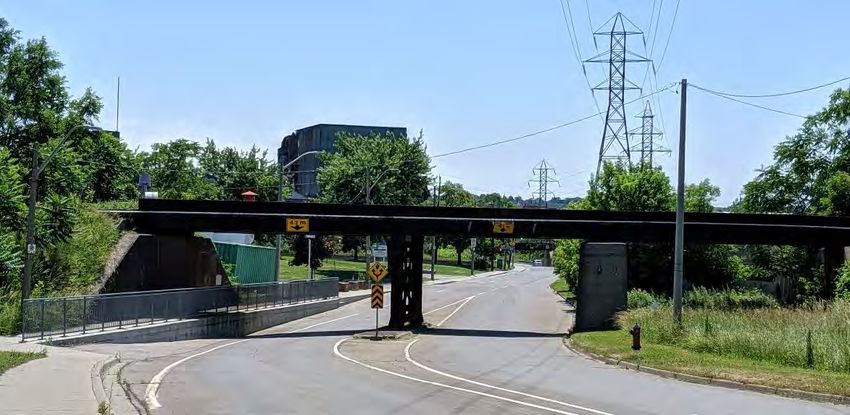
IBI GROUP
BIRCH AVENUE: SCHEDULE B MUNICIPAL CLASS ENVIRONMENTAL ASSESSMENT
Prepared for City of Hamilton
1 Introduction
The City of Hamilton retained IBI Group to conduct the Birch Avenue Municipal Class
Environmental Assessment (EA). Birch Avenue is a minor arterial roadway in north-central
Hamilton that was built on reclaimed land from the former Sherman Inlet (Hamilton Harbour). At
its lowest point, the road surface is approximately 1.3 m above the average water table, though
the separation has come as close as 0.15 m in summer 2019 when record lake levels occurred.
This EA is required to develop a preferred solution that addresses drainage issues that occur
when the storm system reaches capacity. The preferred solution may have property impacts
depending on the outcome (e.g. land for a pumping station).
While drainage is the trigger for this EA, there are a number of inter-related topics explored
within it that influence the development and selection of a preferred solution. These include:
Active Transportation: the City’s active transportation policy supports the
installation of cycling facilities along Birch Avenue and through routine
accommodation to fill in sidewalk gaps. The preferred active transportation facility
may impact drainage requirements if the road surface needs to be widened;
Substandard Roadway Clearance: three rail bridges travel across the corridor:
one is unused and is planned to be removed, while the other two carry daily rail
traffic. All three bridges provide substandard vertical roadway clearance, which
poses a safety hazard in the event a tall truck or bus strikes the bridge. Addressing
this is needed to create a safe, reliable roadway as Hamilton Transit (HSR) plans to
construct a bus facility at Brant Street which will use Birch Avenue as its primary
access route. Increasing clearance may impact drainage if the roadway needs to be
lowered as the lowest points are located at rail underpasses; and,
Flow Reduction Measures: given that the existing sewer system can reach
capacity, options to explore reducing flow volumes and/or increasing capacity are
explored within this EA. These could help reduce the demands placed on the local
storm system and the potential volume of water that needs to be pumped.
These three topics will be explored within this EA, as well as potential siting opportunities for
pumping stations.
1.1 Study Area
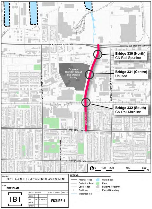
The study corridor is Birch Avenue corridor between Burlington Street East and Barton Street
East in the City of Hamilton (Exhibit 1.1).
A hydro corridor runs along the immediate west side of the roadway. North of the CN Rail
mainline, the primary land use is industrial. South of the CN Rail line, the east side is residential.
The west side contains park land within the hydro corridor, which is adjacent to residential lands.
January 28, 2020 1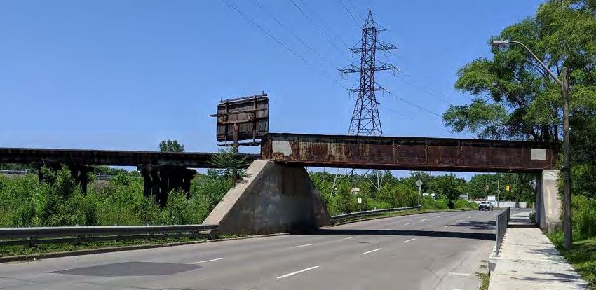
IBI GROUP
BIRCH AVENUE: SCHEDULE B MUNICIPAL CLASS ENVIRONMENTAL ASSESSMENT
Prepared for City of Hamilton

             Exhibit 1.1: Map of the Birch Avenue MCEA Study Area

January 28, 2020                                                    2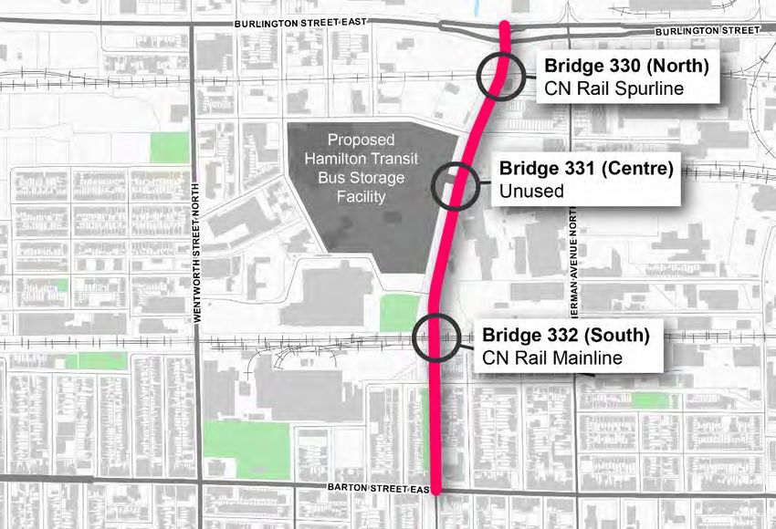
IBI GROUP
BIRCH AVENUE: SCHEDULE B MUNICIPAL CLASS ENVIRONMENTAL ASSESSMENT
Prepared for City of Hamilton

                   1.2       Study Context
                   Birch Avenue, between Burlington Street East and Barton Street East, currently has three lanes
                   in the southbound direction. The road was identified as a preferred candidate for two-way
                   conversion in the 2018 Transportation Master Plan. While the conversion to two-way traffic is
                   approved under the MCEA process, there are a number of other physical and operational
                   constraints to be resolved in this EA.
                   The road has three rail bridges referred to in the City’s database as Bridges 330, 331, and 332.
                   Bridge 330, south of Burlington Street E, is a CN spurline that serves industrial users in the area.
                   Bridge 332 north of Barton Street is CN’s mainline to the USA. Both Bridge 330 and Bridge 332
                   have vertical clearance below standards and are a safety risk for tall vehicles. Bridge 331, south
                   of Brant Street, is abandoned and slated for removal.
                   There are drainage and stormwater issues along the corridor and in particular at the rail
                   crossings where the road elevation is approaching the average water table level. These areas
                   are prone to flooding, and this complicates the bridge clearance issue as lowering the roadway
                   to improve clearance will worsen the drainage issue. A pumping station may be required to
                   address existing and future drainage issues, which is the trigger for this EA.
                   The City has identified Birch Avenue as an active transportation corridor with preliminary plans
                   for a multi-use trail along the west side of the road, though plans are to be reviewed and refined
                   as part of this EA and through detailed design.

                   1.3       Municipal Class Environmental Assessment Process
                   The Municipal Class Environmental Assessment (MCEA) process is a five-phase planning
                   procedure under the Ontario Environmental Assessment Act, which applies to public
                   infrastructure projects (Exhibit 1.2). Projects undertaken through this planning process are
                   classified as one of four Schedule types in accordance with their degree of anticipated
                   environmental impact and magnitude.
                   Exhibit 1.2: Municipal Class Environmental Assessment Process (Municipal Engineers Association)

January 28, 2020                                                                                                        3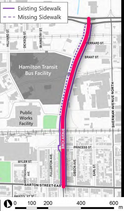
IBI GROUP
BIRCH AVENUE: SCHEDULE B MUNICIPAL CLASS ENVIRONMENTAL ASSESSMENT
Prepared for City of Hamilton
This study follows the Schedule B process. Schedule B EAs generally include
improvements and minor expansions to existing facilities where there is the potential for
some adverse environmental impacts, and therefore, the municipality is required to
proceed through a screening process including consultation with those who may be
affected. Schedule B covers the first two phases of the MCEA process:
Phase 1 Problem or Opportunity: which identifies the deficiency or opportunity.
The problems or opportunities may or may not be evident to the public, but it is
necessary to document factors which lead to the conclusion that an improvement or
change is needed. The outcome of this phase is a clear statement of the problem or
opportunity being addressed.
Phase 2 Alternative Solutions: develop alternative solutions that can solve the
problem and evaluate them against environmental criteria. This step includes taking
an inventory of the natural, social and economic environments and provides
consultation with review agencies and the public to solicit comments and inputs.
The outcome of this phase is the selection of the preferred solution.
A Project File Report is required for Schedule B projects and documents the EA process carried
out. To complete the process, a Notice of Completion will be submitted to review agencies,
stakeholders and the public for a period of at least 30 days for comment and input. The Notice
will include notification for provision to request a Part II Order.
Part II Order
If concerns are raised that cannot be resolved through discussions with the City as the EA
proponent, the Part II Order appeal process may be initiated. If no appeals are brought forth by
the expiry of the review period, the project is considered to have met the requirements of the
MCEA process and the City may proceed with the project.
As part of the MCEA process, it is suggested that all stakeholders work together to determine
the preferred means of dealing with a problem or opportunity. If concerns regarding a project
cannot be resolved in discussion with the proponent, members of the public, interest groups or
technical review agencies may request the Minister of the Environment, Conservation and Parks
(MECP) to require a proponent comply with Part II of the Environmental Assessment Act before
proceeding with the proposed undertaking. The Minister then decides whether to deny the
request, refer the matter to mediation or require the proponent to comply with Part II of the
Environmental Assessment Act.
The procedures for dealing with concerns are outlined as follows:
1. For Schedule ‘B’ projects a person or party with a concern should bring it to the attention of
the City of Hamilton (the proponent) in Phase 2 of the planning process.
2. Should the person or party with the concern wishes to pursue the matter, they may write the
MECP or delegate, or request a Part II Order. These requests shall be copied by the
requestor to the City of Hamilton and the Director of the Environmental Approvals Branch at
MECP at the same time they are submitted to the Minister, or delegate. For a Schedule ‘B’
project, a written request must be submitted to the Minister or delegate within the 30 day
review period after the Notice of Completion has been issued.
January 28, 2020 4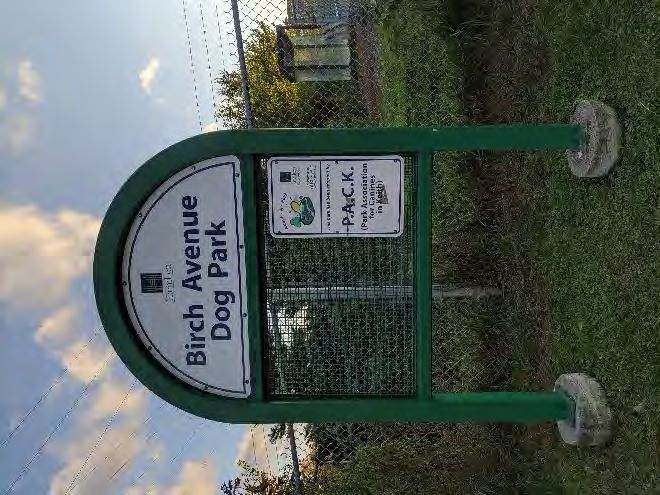
IBI GROUP
BIRCH AVENUE: SCHEDULE B MUNICIPAL CLASS ENVIRONMENTAL ASSESSMENT
Prepared for City of Hamilton
1.4 Study Organization and Project Team
The study organization reflects the general administrative and technical needs of the study as
well as the study’s consultation program. The latter has been developed to ensure that all of
those with a potential interest in the study will have the opportunity to participate and provide
input during the process
The study was carried out under the direction of the Project Team comprised of staff from the
City of Hamilton and IBI Group:
Megan Salvucci, Project Manager, Asset Management, City of Hamilton
City of Hamilton representatives from:
Asset Management
Design
HSR
Hamilton Water
Cultural Heritage
Natural Heritage
Transportation Planning
Transportation Operations & Maintenance
Bruce Mori, Project Director, IBI Group
Scott Johnston, Project Manager, IBI Group
Trevor Jenkins, Environmental Assessment Coordinator, IBI Group
January 28, 2020 5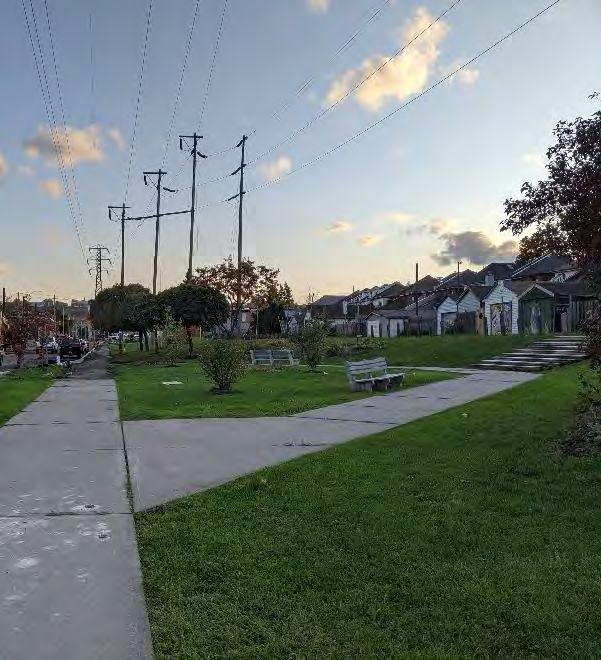
IBI GROUP
BIRCH AVENUE: SCHEDULE B MUNICIPAL CLASS ENVIRONMENTAL ASSESSMENT
Prepared for City of Hamilton
2 Relevant Policies and Studies
The following City documents were reviewed to provide background information on this study.
2.1 City of Hamilton Urban Official Plan
The Urban Hamilton Official Plan came into effect on August 16, 2013.
2.1.1 Functional Road Classification
Exhibit 2.1: Functional Road
Birch Avenue is a ‘Minor Arterial’ in the Schedule C – Classification from UHOP
Functional Road Classification map (Exhibit 2.1). Relevant
policies for this classification are:
The primary function of a minor arterial road shall be to
carry moderate volumes of intra-municipal and inter-
regional traffic through the City in association with other
types of roads.
Land accesses shall be permitted with some controls.
Bicycle lanes may be in place to accommodate cyclists
and sidewalks shall generally be provided on both sides
of the street for pedestrians.
Gateway features may be permitted where required.
On-street parking and loading may be prohibited or at
minimum be restricted in the peak hours.
The corridor is part of the full-time truck route network (Section
2.3.6).
2.1.2 Land Use Designations
The land use designation adjacent to the study area varies by segment (Exhibit 2.2):
Barton Street: properties fronting onto Exhibit 2.2: Land Use Designation from UHOP
Barton Street are designated ‘Mixed
Use – Medium Density’.
Birch Avenue from Barton Street to
CN Mainline (Bridge 332): the lands
on the east side of Birch Avenue are
designated ‘Neighbourhoods.’ The
lands immediately to the west are
zoned ‘Utility’ and ‘Neighbourhoods’
on the other side of the far side of the
hydro corridor.
CN Mainline (Bridge 332) to
Burlington Street: this area is
designated as ‘Industrial Land.’
January 28, 2020 6IBI GROUP
BIRCH AVENUE: SCHEDULE B MUNICIPAL CLASS ENVIRONMENTAL ASSESSMENT
Prepared for City of Hamilton
2.2 Previous Drainage Studies
2.2.1 Birch Avenue Sewer Capacity Analysis (2018)
The City retained GM BluePlan to carry out sewer capacity assessment of the Birch Avenue
Assessment sewer for the sewer sections between Wilson Street and Burlington Street East.
The work used the updated Mike Urban 2014 model. The modelling results confirm that there
are capacity issues along the corridor, and drew the following observations:
Barton Street to Princess Street: hydraulic grade line (HGL) at Princess Street is
less than 1.8 m below ground level under a five year storm + growth scenario.
Princess Street to Brant Street: the model predicts overland flooding of
approximately 0.5 m above ground under a five year storm + growth scenario.
Brant Street to Burlington Street: the HGL is less than 1.8 m below ground level
under a five year storm + growth scenario.
The analysis did not identify any improvements to address capacity deficiencies.
2.2.2 Birch Avenue Stormwater Modelling and Flood Relief (2013)
The City retained McCormick Ranking Corporation to review remedial measures to address
flooding problems. The purpose of the study was to assess the capacity of the existing storm
relief sewer on Birch Avenue between Barton Street and Burlington Street and to identify and
develop alternatives to alleviate flooding related to this sewer.
Modelling work shows that Birch Avenue has inadequate capacity to convey required flows,
which can result in flooding and reduced level of service at the railway underpasses. The report
concludes that “while there is an opportunity to construct additional capacity into the Birch
Avenue storm sewer at the time of its required reconstruction, this measure is not
recommended. Instead, a new storm relief sewer on Sherman Avenue is the prime
recommendation.” This proposed solution would result in a hydraulic grade line in the Birch
Avenue trunk storm relief sewer that would be below the ground surface during 5-year events.
2.3 Transportation and Structural Studies
2.3.1 Hamilton Transit Bus Maintenance and Storage Facility
The City of Hamilton is conducting a separate environmental assessment for a new bus
maintenance and storage facility. Upon its opening, the facility will be able to support
approximately 200 buses and can be expanded to accommodate an additional 100 buses (300
total). At full build-out, there will be approximately 820 staff using the facility, and at peak times
will have around 300 employees reporting to the facility.
The main bus access for the facility will link to Birch Avenue and will be in proximity to Bridge
331 (Exhibit 2.3). An emergency secondary access point will connect to Brant Street just west of
Brant Street. As Birch Avenue will be the primary access route for buses travelling to and from
the facility, the roadway needs to be safe and efficient to maintain optimal operations for vehicles
travelling to and from the facility.
January 28, 2020 7IBI GROUP
BIRCH AVENUE: SCHEDULE B MUNICIPAL CLASS ENVIRONMENTAL ASSESSMENT
Prepared for City of Hamilton
Exhibit 2.3: Access Points to Bus Maintenance and Storage Facility
2.3.2 Bridges 330 and 332 Functional Study Reports (2017)
SNC-Lavalin was retained to conduct functional studies for Bridge 330 (North) and Bridge 332
(South), as shown in Exhibit 2.4. The purpose was to review the alternatives crossings possible
at the two locations to reduce the associated maintenance costs and resolve low vertical
clearance.
Exhibit 2.4: Railway Bridge Locations
January 28, 2020 8IBI GROUP
BIRCH AVENUE: SCHEDULE B MUNICIPAL CLASS ENVIRONMENTAL ASSESSMENT
Prepared for City of Hamilton
Bridge 330 has a clearance of 4.1 m, and Bridge 332 has a clearance of 4.2 ms. Both are lower
than the MTO standard of 4.8 m of clearance.
The options considered for both sites include:
Option 1: Replacement of the existing crossing with a new structure; or,
Option 2: Modification of the road profile to convert the existing bridge to an at-
grade crossing (50km/h and 60km/h design speed options).
Conceptual plans and profile drawings for each option were prepared. They were evaluated
based on property impacts, utilities, road profile, construction staging and time, and financial
analysis. Both studies recommended at-grade crossings at the two sites. The option has the
lowest construction cost and will have minimal maintenance cost relative to the bridge
replacement option. However, it would have the most impact on utilities, property and road
profile.
A third option for both crossings was explored in a separate memo. Option 3 would close the
road at Bridges 330 and 332 and replace the bridges with retaining walls and slopes. The
specific road closures would be:
Bridge 330: from Princess Street to the City’s Operation Centre Entrance
(approximately 195 m)
Bridge 332: from Gerrard Street to Burlington Street (approximately 195 m). The
option would remove the traffic signals and dual left-turn lanes at the Birch Avenue
and Burlington Street intersection.
This road closure option was compared against Options 1 and 2 using the same criteria and was
found to be the preferred option. It was found to be the most economical, least disruptive to the
rail tracks, and have the lowest impact on private property. However, closing the road is no
longer a viable option as the bus facility requires Birch Avenue for access.
2.3.3 Transportation Master Plan Update (2018)
City Council endorsed the Hamilton Transportation Master Plan (TMP) in August 2018. The TMP
is a multi-modal plan addressing all modes including walking, cycling, transit, automobiles and
goods movement. It “provides a comprehensive and attainable transportation blueprint for
Hamilton as a whole that balances all modes of transportation to become a healthier city. The
success of the plan is based on specific, measurable, achievable, relevant and programmed
results.” The plan includes discussion papers on relevant policy areas that are integrated into the
final TMP. Select policy areas are discussed below.
Complete-Livable-Better Streets
The TMP proposes adopting a Complete-Livable-Better (CLB) Streets approach to right-of-way
design, drawing on elements of the complete streets movement. The CLB approach aims to
balance the needs of all uses and users regardless of age, ability or mode of transportation in an
equitable manner. It represents a shift from traditional street design approaches where the
primary focus is moving vehicular traffic. Development of a CLB Design Manual is a future action
though the principles should be integrated into this work.
Two-Way Conversion
The Background Report: Street (One- to Two-Way) Conversions provides a screening procedure
to facilitate the technical review of future two-way conversions for the remaining one-way streets
in Hamilton. The criteria were developed and included in the TMP to guide staff and Council in
the decision-making process. The preliminary review was applied to select streets for potential
January 28, 2020 9IBI GROUP
BIRCH AVENUE: SCHEDULE B MUNICIPAL CLASS ENVIRONMENTAL ASSESSMENT
Prepared for City of Hamilton
conversion, including Birch Avenue from Burlington Street to Wilson Street. The preliminary
findings rank the conversion of Birch Avenue as the second-highest priority of those examined.
Road Safety and Vision Zero
Road safety is a crucial component of the updated TMP. A balanced and sustainable
transportation system is comfortable for travellers, integrates safety into CLB street design and
ensures the movement of people and goods for economic growth and prosperity happens safely.
Vision Zero is a proactive approach to road safety, with a simple and clear goal of zero fatalities
or serious injuries on roadways. A central element of Vision Zero is that road safety takes
precedence over operations and convenience. Vision Zero focuses on:
Fatalities and serious injuries;
Flaws in the transportation system as a cause of collisions;
Perfecting road systems for imperfect human behaviour; and,
Safety initiatives to reduce societal costs.
Safety for all users – drivers, passengers, cyclists and pedestrians – using Birch Avenue will be
a factor in the selection of a preferred solution. This will include addressing road safety for
vulnerable road users of all ages and ability and encouraging a healthy lifestyle.
2.3.4 Cycling Master Plan Update (2018) Exhibit 2.5: Cycling Master
Plan Update (2018)
The Cycling Master Plan (CMP) identifies a future cycling
infrastructure project on Birch Avenue from Burlington Street to
Wilson Street (Exhibit 2.5).
The design concept suggests installing bike lanes on each side of
the road as part of a two-way conversion road diet. There are
currently no separated or dedicated facilities along Birch Avenue.
2.3.5 Pedestrian Mobility Plan (2013)
The Pedestrian Mobility Plan contains a toolbox of options for
improving the pedestrian experience throughout Hamilton. This
plan uses an evidence-based approach to creating safe and
exciting pedestrian environments by applying public health science
and transportation research to the City’s built environments.
The plan identifies the Study Area as an ‘Industrial’ context area. The characteristics of it are:
“The heavy industrial area adjoining Hamilton Harbour is the City’s heavy
industrial and port area and along Burlington Street. Pedestrian environments
exist to a limited extent where streets have sidewalks. Goods movement and
heavy industrial activities characterize this zone. Aside from public transit
facilities, little opportunity exists to enhance this pedestrian environment except
in peripheral areas like Windemere Basin.”
The plan embeds a “Routine Accommodation” policy within City decision making. Infrastructure
development/renewal should address improved pedestrian environments by using appropriate
solutions. The Toolbox Checklist identifies solutions that may be appropriate for the ‘Industrial’
context area.
January 28, 2020 10IBI GROUP
BIRCH AVENUE: SCHEDULE B MUNICIPAL CLASS ENVIRONMENTAL ASSESSMENT
Prepared for City of Hamilton
2.3.6 Truck Route Master Plan (2010)
The Truck Route Master Plan is intended to Exhibit 2.6: Truck Route Network (April 2017)
recommend a truck route network, and the policies
and implementation strategy that will assist the City in
managing the truck route network. It provides
recommendations for future action, policies for truck
route signage, and a methodology for dealing with
truck route network issues in the future.
The most recent truck route network (Exhibit 2.6)
identifies Birch Avenue as a full-time (24 hour) truck
route from Burlington Street to Barton Street. From
Barton Street to Cannon Street, it is a part-time route
(7:00 a.m. to 7:00 p.m.).
An update to the Truck Route Master Plan study will
commence in 2019.
January 28, 2020 11IBI GROUP
BIRCH AVENUE: SCHEDULE B MUNICIPAL CLASS ENVIRONMENTAL ASSESSMENT
Prepared for City of Hamilton
3 Problem/Opportunity Statement
Phase 1 of the MCEA process involves identification of the problem and/or opportunities and
documentation of the considerations leading to the determination that improvements are
required.
3.1 Need and Justification
A number of background studies have been completed which identify the need and justification
to address drainage issues along the corridor.
3.2 Problem and Opportunity Statement
Phase 1 of the MCEA requires a Problem/Opportunity Statement that captures the key
components that will be addressed in the study. Through the project terms of reference and
input from the public at Public Information Centre 1, the following statement was developed:
Birch Avenue is a one-way, minor arterial serving local, through and goods movement
traffic. Two bridges on the corridor are nearing the end of their design life and need to
be replaced. The height of the bridges above the road (clearance) is substandard, and
there are drainage issues that can cause flooding.
In the near-term, the road will be converted to two-way traffic and will become the
primary access route to the Hamilton Transit Bus Maintenance and Storage Facility.
The City is looking for opportunities to resolve clearance, address drainage issues, and
implement active transportation infrastructure and traffic operational improvements for
the benefit of users.
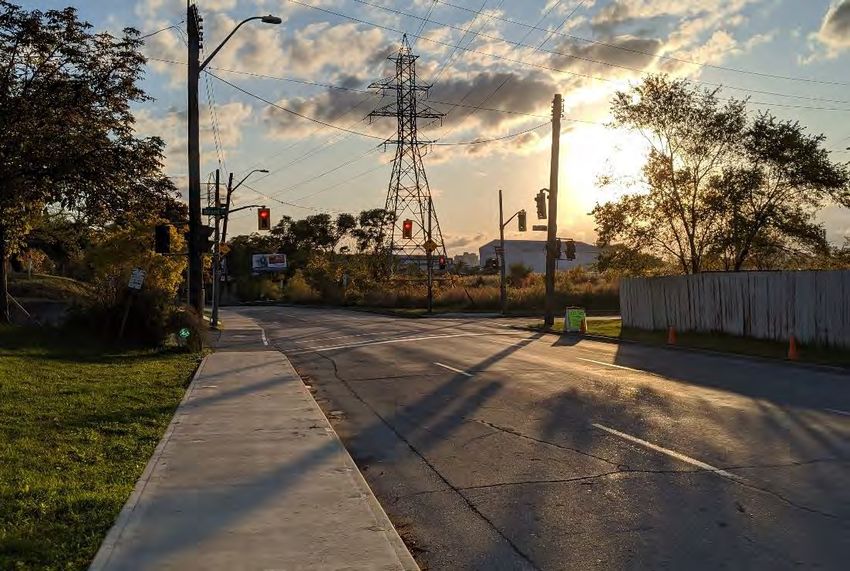
Exhibit 3.1: Looking south towards Brant Street (IBI Group)
January 28, 2020 12IBI GROUP
BIRCH AVENUE: SCHEDULE B MUNICIPAL CLASS ENVIRONMENTAL ASSESSMENT
Prepared for City of Hamilton
4 Existing Conditions
4.1 Natural Environment
A Natural Heritage Report was completed by LGL Limited. The investigation was completed to
inventory and survey the habitat, vegetation and wildlife within the study area. Key findings are
summarized within this section.
The full report is available in Appendix B.
4.1.1 Habitats
Designated Natural Areas
A review of the Ministry of Natural Resources and Forestry Natural Heritage Information Centre
database and the City of Hamilton Urban Official Plan indicates that there are no Areas of
Natural and Scientific Interest, Provincially Significant Wetlands or Environmentally Sensitive
Areas located within 120 m of the study area.
Aquatic Habitat
There are no watercourses or waterbodies located within the study area; therefore, no fish
habitat is present.
Terrestrial
Limited wildlife and wildlife habitat were found within the study area. Natural heritage features
consisted primarily of manicured grass, cultural meadow and cultural thicket. The highest quality
wildlife habitat found within the study area is provided by the cultural thicket and cultural
meadow communities.
4.1.2 Vegetation
Flora
A total of 67 plant species have been recorded within the study area. Of the 67 plants identified
to species, 25 (37%) plant species identified are native to Ontario and 42 (63%) plant species
are considered introduced and non-native to Ontario.
Trees
A tree inventory was completed for the Study Area by an ISA certified arborist. The inventory
identifies the species, measurement at breast height, location and health assessment. A total of
112 trees consisting of 24 species were inventoried during the field investigation.
Overall, trees within the study limits range in size from 4 to 55 cm diameter at breast height and
are generally considered to be in good to fair condition. One plant species regulated as
Threatened under the Endangered Species Act, 2007 was observed: four Kentucky coffee trees
were noted as planted amenity trees. Consultation with Ministry of Environment, Conservation
and Parks Management Biologists have advised that streetscape Kentucky coffee-trees likely
are cultivars and as such, they are not protected under the Endangered Species Act.
January 28, 2020 13IBI GROUP
BIRCH AVENUE: SCHEDULE B MUNICIPAL CLASS ENVIRONMENTAL ASSESSMENT
Prepared for City of Hamilton
4.1.3 Wildlife
Field investigations revealed that the study area supports an assemblage of common species
that are typical of a highly disturbed landscape. The breeding bird community was primarily
composed of urban, tolerant, habitat generalist bird species. Significant wildlife habitat
(amphibian breeding, reptile hibernacula, etc.) was not identified within the study area. No
significant wildlife movement or passage corridors were identified within the lands examined.
Birds
Field investigation revealed that the study area contained a moderate number of breeding bird
species representing several habitat types. Breeding evidence was obtained for 20 species of
birds. Breeding evidence was confirmed in one species, probable in six species, possible in
seven species, and observed in an additional six species.
Bird species identified in the study area include:
American Goldfinch European Starling Northern Mockingbird
American Robin Gray Catbird Red-winged Blackbird
Bank Swallow1 House Finch Ring-billed Gull
Barn Swallow1 House Sparrow Rock Dove (Pigeon)
Blue Jay Indigo Bunting Song Sparrow
Chimney Swift1,2 Mourning Dove Yellow Warbler
Common Grackle Northern Cardinal
The rail bridges may provide nesting opportunities for Barn Swallow, but during field surveys no
nests were observed under any of the three bridges. No nests of migratory bird species were
identified during field investigations.
Mammals
Four mammal species were identified during field investigations in the study area:
Eastern cottontail Northern raccoon
Eastern gray squirrel Groundhog
The mammal species documented represent an assemblage that readily utilizes human
influenced landscapes. None are identified as species at risk.
4.2 Social, Economic and Cultural Environments
4.2.1 Socio-Economic
The Study Area is located in the neighbourhoods known as Industrial Sector B/Keith (north of
Bridge 332) and Gibson (south of Bridge 332). The section of Birch Avenue between Princess
Street and Burlington Street is primarily industrial in nature, while the section between Princess
Street and Barton Street is primarily residential on the east side and open space under the hydro
corridor on the west side.
There are two community parks within the study area (Exhibit 4.1). The first is the Birch Avenue
Dog Park, which is located at the southeast corner of the Public Works Facility and is accessed
1
Identified as Threatened under the provincial Ontario Endangered Species Act
2
Identified as Threatened under the federal Species at Risk Act
January 28, 2020 14IBI GROUP
BIRCH AVENUE: SCHEDULE B MUNICIPAL CLASS ENVIRONMENTAL ASSESSMENT
Prepared for City of Hamilton
through the Public Works Facility driveway. The second is Birch Park, which is located
underneath the hydro corridor from just south of Princess Street to just north of Barton Street.
Exhibit 4.1: Birch Avenue Dog Park (left) and Birch Park (right) (IBI Group)
Both the Keith and Gibson neighbourhoods are included in the City of Hamilton’s Neighbourhood
Action Strategy, which identifies areas of Hamilton where social and economic inequalities are
having impacts on residents’ health. The Social Planning and Research Council of Hamilton
prepared neighbourhood profiles3 for the two communities that identify challenges the
neighbourhood face4:
There is a larger proportion of residents with activity limitations than in the City;
The poverty rate in the area is more than double the city average. More than four in
ten Keith residents (43%) and over one in three Gibson residents (37%) are living in
poverty;
The rate of students not completing high school in Keith (17.4%) is more than three
times the city-wide median, while in Gibson the rate is slightly lower (15.5%) but still
above the city-wide median; and,
The average age of death in Keith is 65.6 years, which is 9.7 years younger than
the Hamilton median. In Gibson, the average age is higher at 71.5 years, which is
still 3.7 years lower than the city median.
It is apparent that this road runs through a community in need. This study presents an
opportunity to support vulnerable road users and residents that travel or live along the corridor.
4.2.2 Built and Cultural Heritage Landscape
A Cultural Heritage Resource Assessment was completed by ASI. The report presents an
inventory of cultural heritage resources within the study area and identifies the existing
conditions, potential impacts to heritage resources and proposed appropriate mitigation
measures. The report identified that area is historically and contextually associated with the early
twentieth century land use patterns in the City of Hamilton.
3
http://www.sprc.hamilton.on.ca/wp-content/uploads/2012/03/2012-Report-Neighbourhood_Profiles_March.pdf
4
The Gibson neighbourhood was included in a larger “South Sherman” neighbourhood profile.
January 28, 2020 15IBI GROUP
BIRCH AVENUE: SCHEDULE B MUNICIPAL CLASS ENVIRONMENTAL ASSESSMENT
Prepared for City of Hamilton
A field review of the study area confirmed there are 11 cultural heritage resources (Exhibit 4.2)
consisting of the following within or immediately adjacent to the study area:
Three bridges,
Two commercial buildings,
One former school,
One industrial building complex,
Two streetscapes, and
Two transportation corridors area.
Three of the cultural heritage resources are identified by the City of Hamilton as Inventoried, one
was identified by the City of Hamilton on the Register, the three bridges were previously
identified by the City of Hamilton Heritage Bridge Inventory, and the remainder were previously
identified by ASI in 2012 during a field review.
The report is available in Appendix C.
January 28, 2020 16IBI GROUP
BIRCH AVENUE: SCHEDULE B MUNICIPAL CLASS ENVIRONMENTAL ASSESSMENT
Prepared for City of Hamilton
Exhibit 4.2: Map of identified built heritage resources and cultural heritage landscapes
4.2.3 Archaeology
A Stage 1 Archaeology Assessment was completed by ASI. The purpose of the study is to
investigate the past and present land use, the settlement history, and any other relevant
historical information pertaining to the study area.
As can be seen in Exhibit 4.3, the section of the Birch Avenue north of Bridge 332 was part of
the Sherman Inlet (Hamilton Harbour) as recently as 1909. Over the course of the nineteenth
and twentieth centuries the area experienced substantial change and development, including the
infill of the Sherman Inlet and complete alteration of the Hamilton Harbour shoreline, as well as
industrial, commercial and residential development.
January 28, 2020 17IBI GROUP
BIRCH AVENUE: SCHEDULE B MUNICIPAL CLASS ENVIRONMENTAL ASSESSMENT
Prepared for City of Hamilton
Exhibit 4.3: Study Area (approximate) overlaid on the 1909 NTS Hamilton Sheet
Based on the findings in the report, it is recommended that no further archaeological studies be
completed.
The report is in draft form and has been submitted to the Ministry of Heritage, Sport, Tourism
and Culture Industries for review. The report is currently pending entry into the Ontario Public
Register of Archaeological Reports and, once accepted, will be confirmed to have satisfied the
Ministry’s standards.
4.3 Sewer System and Flooding Issues
4.3.1 Storm Relief Sewer
Under existing conditions, runoff from Birch Avenue is primarily collected by catch basins,
conveyed by storm relief sewers and finally discharged into Lake Ontario through the outlet
located north of Burlington Street East.
The existing storm relief sewer along Birch Avenue is a concrete structure with the size of 1450
mm by 1800 mm located under the sidewalk on the east side of Birch Avenue between
Burlington Street East and Princess Street. South of Princess Street along Birch Avenue, the
size of the storm relief sewer changes to 1200 mm by 1550 mm. The slope of the storm relief
sewer along Birch Avenue between Barton Street East and Burlington Street East varies from
0.05% to 0.4%. These low gradients reduce the sewer capacity. The sewer obvert is above the
road elevation, particularly where the road sags at the railway underpasses. The storm relief
sewer is integral to the footings of each of the three railway bridge abutments.
4.3.2 Combined Sewer
The catchment area located south of Princess Street is serviced by the existing combined sewer
system. The existing sewer along Birch Avenue also has a combined sewer which varies in size
and gradient. The combined sewer between Wilson Street and Princess Street has a 600 mm by
900 mm non-circular section and the slope varies from 0.3% to 0.6%. Between Barton Street
East and Princess Street, there is a parallel storm relief trunk sewer (1200 mm by 1314 mm) in
addition to the 600 mm by 900 mm combined sewer. The storm relief sewer flows north towards
Burlington Street East, while the combined sewer (600 mm by 900 mm) connects to the Princess
Street combined sewer system and continues to flow east.
The combined sewer network located at the intersection of Birch Avenue and Princess Street
discharges wet weather flow into the Birch Avenue storm relief sewer through an overflow
January 28, 2020 18IBI GROUP
BIRCH AVENUE: SCHEDULE B MUNICIPAL CLASS ENVIRONMENTAL ASSESSMENT
Prepared for City of Hamilton
chamber located at the intersection of Birch Avenue and Princess Street. The low sanitary flow
is conveyed east along Princess Street through the combined sewer system. As a result, the
storm and sanitary sewer system are completely separate along Birch Avenue from Princess
Street to the outfall located north of Burlington Street.
4.3.3 Sanitary Sewer
There is a sanitary sewer that runs towards north along Birch Avenue to service roadway
adjacent areas. This sanitary sewer starts at the railway crossing north of Princess Street
(Bridge 332), continues north and discharges to the Burlington Street sanitary sewer system.
4.3.4 Flooding Issues
There are three low points along Birch Avenue at the three railway bridges. The slope of the
existing storm relief sewer between Barton Street East and Burlington Street East varies from
0.05% to 0.4%. These low gradients reduce the sewer capacity. It is well recognized that the
capacity of the existing storm sewer on Birch Avenue is not adequate to convey the required
design flows. This inadequate flow capacity of the storm sewer results in undesirable flooding
and level of service under the bridges. The storm relief sewer obvert is also above the road
elevation at some locations, particularly at/near the railway underpasses.
A significant factor for flooding is the level of Lake Ontario and its hydraulic effect on the sewer’s
outlet. Summer average lake level is approximately 75.0 m as shown in Exhibit 4.4. The road
elevation at the bridge low-points are 75.69 m (Bridge 330), 76.0 m (Bridge 331) and 76.40 m
(Bridge 332) from north to south respectively. The sewer height ranges from 74.29 m at
Burlington Street, 75.0 m just north of Bridge 332, 75.20 m at Princess Street and 76.29 m at
Barton Street. This means that the water table is reaching the physical sewer infrastructure until
just north of Bridge 332, which can contribute to drainage issues.
Exhibit 4.4: Lake Ontario Average Water Levels
January 28, 2020 19IBI GROUP
BIRCH AVENUE: SCHEDULE B MUNICIPAL CLASS ENVIRONMENTAL ASSESSMENT
Prepared for City of Hamilton
4.4 Transportation and Structural
4.4.1 Existing Traffic Operations
A transportation assessment was completed to determine existing traffic operations through the
study area and at nearby intersections. A copy of the memo is available in Appendix D.
The primary metric for traffic flow performance is level-of-service (LOS). It is a measure of
intersection performance based on the average delay experienced by drivers (Exhibit 4.5). An
intersection operations analysis was conducted using Synchro (version 9) and following Highway
Capacity Manual (HCM 2000) methodologies of intersection analysis.
Exhibit 4.5: Intersection Level of Service (LOS) Reference
Control Delay Per Vehicle (s)
Level Of Service Signalized Unsignalized
A ≤10 ≤10
B >10 and ≤20 >10 and ≤15
C >20 and ≤35 >15 and ≤25
D >35 and ≤55 >25 and ≤35
E >55 and ≤80 >35 and ≤50
F >80 >50
Analysis periods were the weekday a.m. and p.m. peak hours, when background traffic is
considered highest (Exhibit 4.6).
Based on the results, the intersections in the study area are currently operating well, with
signalized intersections at level-of-service B or better (Exhibit 4.7). No movements in either peak
periods are considered critical according to the City’s traffic impact study guidelines, indicating
stable traffic conditions without significant delay or disruptions
January 28, 2020 20IBI GROUP BIRCH AVENUE: SCHEDULE B MUNICIPAL CLASS ENVIRONMENTAL ASSESSMENT Prepared for City of Hamilton Exhibit 4.6: Existing Traffic Conditions: Traffic Volumes January 28, 2020 21
IBI GROUP
BIRCH AVENUE: SCHEDULE B MUNICIPAL CLASS ENVIRONMENTAL ASSESSMENT
Prepared for City of Hamilton
Exhibit 4.7: Existing Traffic Analysis (All Movements) Summary
All Movements
V/C 95th Percentile
Intersection Name Overall LOS Mvmt LOS Ratio Queue (m)
AM Peak
Birch Avenue & EBTR A 0.25 23
Burlington Street E A WBL C 0.34 31
(Signalized) WBT A 0.35 -
EBTR B 0.06 9
Birch Avenue &
B WBTL B 0.09 13
Brant Street (Signalized)
SBTLR A 0.13 21
EBTR A 0.05 1
Birch Avenue &
- WBTL A 0.04 1
Princess Street (Unsignalized)
SBTLR - 0.01 0
EBTR B 0.30 34
WBL B 0.15 12
Birch Avenue &
B WBT B 0.33 39
Barton Street E (Signalized)
SBTL A 0.12 6
SBR A 0.05 -
PM Peak
EBTR A 0.39 41
Birch Avenue &
A WBL C 0.31 29
Burlington Street E (Signalized)
WBT A 0.28 -
EBTR B 0.05 8
Birch Avenue &
B WBTL B 0.14 18
Brant Street (Signalized)
SBTLR A 0.12 20
EBTR B 0.10 2
Birch Avenue &
- WBTL B 0.05 1
Princess Street (Unsignalized)
SBTLR - 0.02 1
EBTR B 0.42 50
WBL B 0.22 15
Birch Avenue &
B WBT C 0.50 61
Barton Street E (Signalized)
SBTL B 0.15 11
SBR A 0.04 3
4.4.2 Active Transportation
The following infrastructure is available along Birch Avenue (Exhibit 4.8):
A continuous sidewalk on the east side of the street from Barton Street to
Burlington Street;
A sidewalk on the west side between Barton Street and the Public Works Facility
driveway. There is no sidewalk from the Public Works Facility driveway to
Burlington Street;
Signalized pedestrian crossings are available at Barton Street and at Brant Street.
At Burlington Street, the existing signals allow pedestrians to cross east-west on the
south side of the intersection, but not in any other direction; and,
Cyclists using the corridor today ride within mixed-traffic.
January 28, 2020 22IBI GROUP
BIRCH AVENUE: SCHEDULE B MUNICIPAL CLASS ENVIRONMENTAL ASSESSMENT
Prepared for City of Hamilton
Exhibit 4.8: State of pedestrian infrastructure
4.4.3 Bridges
Three rail bridges span Birch Avenue. All three have substandard vertical clearance compared
to the MTO design standard of 4.8 m5. Of the three bridges, two are currently in use by CN Rail
(Bridges 330 and 332), while the third is unused and planned to be removed (Exhibit 4.9).
Exhibit 4.9: Summary of Rail Structures crossing Birch Avenue
Bridge ID Location Use Vertical Clearance Notes
330 (North) 75 m south of CN Rail Substandard
Burlington Street East spurline
331 (Centre) 125 m south of Brant Unused Substandard Planned to be
Street removed
332 (South) 95 m south of Princess CN Rail Substandard Part of the Lakeshore
Street mainline West GO Rail corridor
5
MTO Design Supplement for TAC Geometric Design Guide for Canadian Roads, June 2017, Section 3.3.5.5, requires 4.8 m for railway
bridges over roadways
January 28, 2020 23IBI GROUP
BIRCH AVENUE: SCHEDULE B MUNICIPAL CLASS ENVIRONMENTAL ASSESSMENT
Prepared for City of Hamilton
Bridge 330
The northernmost bridge carries a CN Rail spurline over top of Birch Avenue and is known
municipally as Bridge 330. It is located 75 m south of Burlington Street East. It is a through plate
girder structure with concrete deck. The substructures consist of concrete abutments and
concrete and steel piers. The bridge was constructed in 1923 and repairs to the structural steel
members indicate that the bridge has been rehabilitated.
Exhibit 4.10: Looking south towards Bridge 330 from Burlington Street (IBI Group)
The structure is generally in poor to fair condition with moderate-severe corrosion and rust
jacking of various members of the steel pier; severe rusting at the north girder’s west end with
perforation hole, local repair works on the girders and steel bent indicate the previous impact
damages on these elements; as well as localized delamination/spall on the concrete pier and
abutments.
The existing vertical clearance of 4.1 m on the western portion and 4.2 m on the eastern section
is below the required minimum of 4.8 m. Due to its condition, the bridge is planned to be
replaced. The new structure will be required to meet the minimum clearance.
In 2002, the bridge had been assessed as having moderate heritage value (Class C) in the
Heritage Structure Report. However, a Cultural Heritage Evaluation Report (CHER) conducted in
2017, did not find the bridge to have significant cultural heritage value or interest when assessed
using Ontario Regulation 9/06 and the Hamilton Bridge Guideline.
Bridge 331
The centre bridge is an unused rail bridge that carries a single rail track over Birch Avenue, and
is known municipally as Bridge 331. The superstructure of the through girder section of the
bridge consists of steel girders that are fastened together with steel angles and rivets. The top
flange of both girders is curved at the abutments. Four timber trestles are located immediately
west of the through girder section of the bridge and comprise the remaining four spans
January 28, 2020 24IBI GROUP
BIRCH AVENUE: SCHEDULE B MUNICIPAL CLASS ENVIRONMENTAL ASSESSMENT
Prepared for City of Hamilton
Exhibit 4.11: Looking north at Bridge 331 from the east side of Birch Avenue (IBI Group)
The bridge previously carried a T.H. & B. Railway spurline over the roadway. However, the
bridge is now unused and the tracks on the west side have been removed. The bus facility
(Section 2.3.1) is planned for the lands to the west of the hydro corridor and will prevent tracks
from being installed again.
The bridge is planned to be removed. The bridge has been found to have cultural heritage value
or interest in a CHER. A Heritage Impact Assessment was completed by the City of Hamilton to
determine an appropriate plan for its removal (Appendix C).
Bridge 332
The southernmost bridge is known municipally as Bridge 332. The structure carries the CN Rail
mainline to/from Niagara Region and the US, and GO Transit’s Lakeshore West rail service
between Hamilton and Niagara. The bridge is a two-span through plate girder structure with a
concrete deck. The substructures consist of concrete abutments and structural steel bent pier.
Exhibit 4.12: Looking south at Bridge 332 across from the Public Works Facility driveway (IBI Group)
The structure is generally in fair condition with minor impact damage to the girders and gusset
plates, severe corrosion on the bottom flange of the floor beam near the west abutment,
structural steel coating failure, and, localized delamination/spall on the concrete abutments.
January 28, 2020 25IBI GROUP
BIRCH AVENUE: SCHEDULE B MUNICIPAL CLASS ENVIRONMENTAL ASSESSMENT
Prepared for City of Hamilton
The existing vertical clearance of 4.2 m is sub-standard and below the required minimum of 5.5
m. The bridge is planned to be replaced.
In 2002, the bridge had been assessed as having moderate heritage value (Class C) in a
Heritage Structure Report. A CHER conducted in 2017 did not find the bridge to have significant
cultural heritage value or interest when assessed using Ontario Regulation 9/06 and the
Hamilton Bridge Guideline.
January 28, 2020 26IBI GROUP
BIRCH AVENUE: SCHEDULE B MUNICIPAL CLASS ENVIRONMENTAL ASSESSMENT
Prepared for City of Hamilton
5 Active Transportation and Roadway Clearance
There are two separate, but closely integrated, considerations that will influence the
development and evaluation of the alternative solutions to address drainage. These topics were
considered within the context of this EA to ensure their potential impact on drainage was
properly captured when developing and evaluating alternative solutions:
Active Transportation: the preferred active transportation facility for the corridor may
increase the impervious surface area. It will also require horizontal space under the
bridges which may influence the preferred roadway clearance option; and,
Roadway Clearance: the bridge structures along the corridor have substandard
roadway clearance. It is likely that the preferred option to increase clearance will involve
lowering the roadway, which will impact drainage requirements.
These two subjects are not the trigger of this EA but are contemplated within it.
5.1 Active Transportation
As previously discussed, Birch Avenue has been identified for cycling facilities in the Cycling
Master Plan (Section 2.3.4), and the Pedestrian Mobility Plan supports route accommodation
(Section 2.3.5). This section explores how cycling and pedestrian facilities can be incorporated.
The selection of a preferred active transportation facility type has potential to impact the
preferred drainage solution. If the road needs to be widened to accommodate an on-street or in-
boulevard facility, then the drainage area will increase, while if a facility is located off-street, then
the drainage area would remain the same.
5.1.1 Alternative Facility Type Selection
A Cycling Facility Selection Review was undertaken to determine which type of cycling facilities
would be appropriate for the corridor. The process for selecting facility class is summarized
below.
The facility class selection memo is available in Appendix D.
1. Pre-Selection of Facility Class
The cycling facility selection tool provided in Ontario Traffic Manual (OTM) Book 18 was used to
select the minimum level of cycling facility required for the study area. The classes considered
by the tool can be broadly defined as follows:
Shared Facilities – consisting of signed routes, bicycle boulevards or advisory bike
lanes (most appropriate along low-volume, low-speed roadways);
Designated Facilities – consisting of bike lanes along urban roadways or paved
shoulders along rural roads (typically most appropriate along collector type; and,
Separated Facilities – consisting of buffered or protected bike lanes, cycle tracks
or multi-use trails (typically most needed along arterial roadways, or as part of an all
ages and ability (AAA) or priority network).
It was determined that designated or separated facilities would both be appropriate based on
current/future traffic volumes and the posted speed limit (Exhibit 5.1).
January 28, 2020 27IBI GROUP
BIRCH AVENUE: SCHEDULE B MUNICIPAL CLASS ENVIRONMENTAL ASSESSMENT
Prepared for City of Hamilton
Exhibit 5.1: OTM Book 18 Minimum Facility Selection Tool
2. Detailed Review of Facility Classes
The two facility classes were evaluated against a set of criteria (Exhibit 5.2). The purpose was to
determine whether any specific roadway, safety, user or operational considerations preclude
either a designated or separated cycling facility along the corridor.
Exhibit 5.2: Detailed Facility Class Review Criteria
Primary Criteria Secondary Criteria
Speeds Costs
Volumes Anticipated User
Street Function Level of Use
Vehicle Mix Route Function
Collision History Road Projects
Available Space Parking
Intersections
The evaluation confirmed that designated or separated cycling facility are appropriate for the
corridor context.
3. Alternative Facility Options
The selection of an appropriate cycling facility type within the designated and separated classes
depends on several factors. For example:
Continuity – How will the link connect to cycling facilities upstream or downstream
of the study area? How can the link provide a continuous and cohesive cycling
facility?
Land Use Context / Driveways – How will the land use context influence the
demand for cycling facilities? Are driveways closely spaced or intermittent?
Access to Key Destinations – Are destinations located on both sides of the street
or only one side of the street? What key destinations does this route serve?
Existing / Future Demand – Is there low/ high ridership presently? Are significant
changes in land use anticipated that will impact future ridership?
January 28, 2020 28You can also read