Moorabool Hike and Bike Strategy - June 2014 - Completed by SGL Consulting Group Australia Pty Ltd Leisure and Tourism Planners
←
→
Page content transcription
If your browser does not render page correctly, please read the page content below
Moorabool Hike and Bike Strategy
                      June 2014

Completed by SGL Consulting Group Australia Pty Ltd
           Leisure and Tourism Planners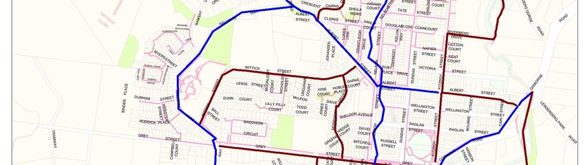
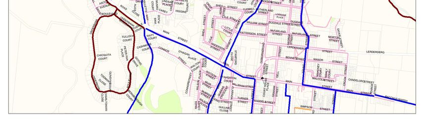
TABLE OF CONTENTS
EXECUTIVE SUMMARY ..................................................................................................................... i
1   INTRODUCTION ....................................................................................................................... 1
  1.1      PROJECT OBJECTIVES ................................................................................................. 1
      1.2               PROJECT METHODOLOGY .......................................................................................... 1
      1.3               OVERVIEW OF MOORABOOL SHIRE............................................................................ 2
      1.4               THE BENEFITS OF WALKING AND CYCLING ................................................................ 2
      1.5      PARTICIPATION IN WALKING AND CYCLING ............................................................. 3
        1.5.1  Relevant Findings from the National Cycling Participation Survey 2011.................. 4
      1.6      KEY ORGANISATIONS THAT SUPPORT CYCLING......................................................... 5
        1.6.1  Cycling Victoria ................................................................................................................... 5
        1.6.2  AustCycle .............................................................................................................................. 5
        1.6.3  Bicycle Network Victoria .................................................................................................... 5
        1.6.4  Victoria Walks ....................................................................................................................... 6
        1.6.5  The Heart Foundation ......................................................................................................... 6
      1.7      REVIEW OF PREVIOUS RELEVANT RESEARCH .............................................................. 6
        1.7.1  Moorabool Shire Recreation and Open Space Strategy 2007 .................................. 6
        1.7.2  Moorabool 2041 .................................................................................................................. 7
2        OVERVIEW OF CONSULTATION ................................................................................................ 8
      2.1               RESIDENT SURVEY KEY FINDINGS SUMMARY .............................................................. 8
        2.1.1           Residents Survey Key Findings Summary ......................................................................... 8
      2.2               HEALTH AND WELLBEING EXPO................................................................................... 9
      2.3               BACCHUS MARSH AND DISTRICT TRACKS AND TRAILS COMMITTEE (BMDTAC) ........ 9
        2.3.1           Key Issues Identified by BMDTAC...................................................................................... 9
      2.4               GREAT DIVIDING TRAIL COMMITTEE ........................................................................... 9
  2.5      GENERAL COMMUNITY CONSULTATION .................................................................. 10
    2.5.1 Myrniong Recreation Reserve Committee of Management ................................... 10
    2.5.2 Elaine Recreation Reserve Committee of Management ......................................... 10
    2.5.3 Wallace Recreation Reserve Committee of Management ..................................... 10
    2.5.4 Bacchus Marsh Tourism Association - Avenue of Honour Heritage Trail ................. 10
    2.5.5 Ballan Resident 1 – Telephone Consultation ................................................................ 10
    2.5.6 Ballan Resident 2 – via email ........................................................................................... 10
3   KEY ISSUES AND OPPORTUNITIES........................................................................................... 12
  3.1      KEY ISSUES ................................................................................................................. 12
    3.1.1 Options to Address North South Access through Bacchus Marsh ........................... 12
4   MOORABOOL HIKE AND BIKE STRATEGIC DIRECTIONS ........................................................ 14
  4.1      MOORABOOL HIKE AND BIKE STRATEGY VISION ..................................................... 14
      4.2               STRATEGY PRINCIPLES ............................................................................................... 14
      4.3               STRATEGY OBJECTIVES.............................................................................................. 14
      4.4               MOORABOOL PLANNING SCHEME GUIDING DOCUMENTS .................................... 15
      4.5               MANAGEMENT AND MAINTENANCE OF THE HIKE AND BIKE NETWORK .................. 15
      4.6               PEDESTRIAN PATH NETWORK..................................................................................... 15
      4.7               FUTURE TRAIL/INFRASTRUCTURE STANDARDS AND AMENITIES ................................. 16
        4.7.1           Footpath Standards .......................................................................................................... 17
        4.7.2           Supporting Infrastructure/Amenities .............................................................................. 17
      4.8               SIGNAGE ................................................................................................................... 17
        4.8.1           Emergency Services Telecommunications Authority (ESTA) ..................................... 18
      4.9               RECREATIONAL PATHS/TRACKS/ROADS................................................................... 18

Moorabool Hike and Bike Strategy Draft Report FINALJUNE.docx (VIC 46.2012) - 10 June 2014                                                        Page i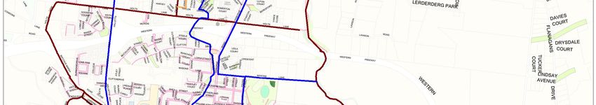
4.10 ROAD CROSSINGS…………………………………………………………………………….20
4.11 PROMOTION OF THE HIKE AND BIKE NETWORK........................................................ 20
4.12 ENCOURAGING WALKING AND CYCLING .............................................................. 21
4.13 FUNDING OPPORTUNITIES ......................................................................................... 21
4.14 REVIEW OF HIKE AND BIKE STRATEGY ....................................................................... 21
5 RECOMMENDED ACTION PLAN and FUTURE WORKS ........................................................... 22
5.1 PLANNING AND MANAGEMENT ACTION PLAN ....................................................... 23
5.2 RECOMMENDED WORKS PROGRAM FOR THE HIKE AND BIKE STRATEGY ................ 25
5.3 FUTURE DEVELOPMENT WORKS MAPS ....................................................................... 35
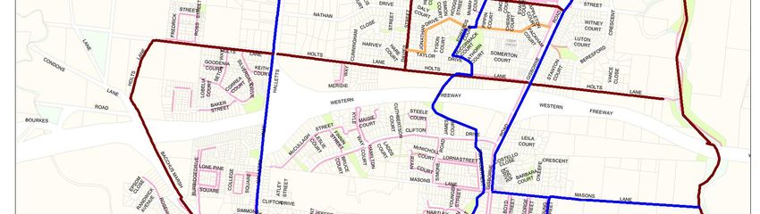
5.3.1 Bacchus Marsh Proposed Hike and Bike Network ...................................................... 36
5.3.2 Ballan Proposed Hike and Bike Network ....................................................................... 39
5.3.3 Blackwood Proposed Hike and Bike Network ............................................................. 40
5.3.4 Bungaree Proposed Hike and Bike Network ................................................................ 40
5.3.5 Dunnstown Proposed Hike and Bike Network.............................................................. 41
5.3.6 Elaine Proposed Hike and Bike Network………………………………………………….42
5.3.7 Gordon Proposed Hike and Bike Network.................................................................... 43
5.3.8 Greendale Proposed Hike and Bike Network .............................................................. 44
5.3.9 Hopetoun Park Proposed Hike and Bike Network....................................................... 45
5.3.10 Lal Lal Proposed Hike and Bike Network....................................................................... 46
5.3.11 Long Forest Proposed Hike and Bike Network ............................................................. 47
5.3.12 Mount Egerton Proposed Hike and Bike Network ....................................................... 48
5.3.13 Myrniong Proposed Hike and Bike Network……………………………………………...49
5.3.14 Wallace Proposed Hike and Bike Network................................................................... 50
DIRECTORY OF TABLES
Table 1.1 Top Ten Physical Activities Victoria..................................................................................3
Table 4.1 Pedestrian Path Priority Criteria ......................................................................................15
Table 4.2 Proposed Path Types ......................................................................................................18
Table 5.1 Hike and Bike Strategy Recommendations ..................................................................23
Table 5.2 Recommended Future Hike and Bike Works Program .................................................25
APPENDIX
APPENDIX ONE: FULL RESIDENT SURVEY ANALYSIS
APPENDIX TWO: BMDTAC PRIORITIES & LONG TERM GOALS 2009
APPENDIX THREE: BMDTAC TOWNSHIP ROUTES
APPENDIX FOUR: PLANNING DOCUMENTS
APPENDIX FIVE: PREVIOUS RESEARCH
APPENDIX SIX: URBAN PATHWAYS HIERARCHY DEFINITIONS
Moorabool Hike and Bike Strategy Draft Report FINALJUNE.docx (VIC 46.2012) - 10 June 2014 Page ii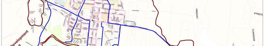
EXECUTIVE SUMMARY
1.0 Introduction

Walking and cycling are two of the most popular activities undertaken by Australians and this
is no different for Moorabool Shire residents and the provision of infrastructure and programs
to support these activities significantly contributes to the health and wellbeing of the
Moorabool Community.

Moorabool Shire Council sought to develop a Hike and Bike Strategy to gain a better
understanding of the hike and bike network needs of the community.

1.1 Purpose of the Strategy

The “Hike and Bike Strategy” provides strategic direction for the planning and development
of the recreation and commuter hike and bike network throughout the Shire. The strategy will
guide Council in its decision making for the future development; provision; management;
maintenance; community education; and marketing of hike and bike networks to support
both the recreation and transport needs of Moorabool Shire residents and visitors to the area.

1.2 Objectives

The project objectives were to:

·      Develop a strategic plan to guide the future development of Council’s hike and bike
       network.

·      Research and identify the needs and expectations of the community using a range of
       consultative measures.

       Identify the network considering categories such as commuter walk, communter cycle,
       recreation walk and recreation cycle
·      Prioritise further development of the hike and bike path network within the municipality
       with development of an action list identifying key works and rationale for inclusion.

·      Recommend future funding opportunities for proposed improvement works and
       programs.

It is noted that Council faces significant challenges:

-      in providing for an ever expanding population;
-      in meeting the increasing expectations about the standard to which paths and trails and
       associated infrastructure will be provided, and constructed;
-      as well as improving the connectivity of paths/trails to key destinations within areas.

(The Hike and Bike Strategy includes recommendations on strategic paths of travel across the
Shire that have strategic justification to support the hike and bike network).

1.3 Market Research Consultation

A range of community engagement and consultation was undertaken by SGL in order to
identify community perspectives on current issues and priorities in relation to the development

Moorabool Hike and Bike Strategy Draft Report FINALJUNE.docx (VIC 46.2012) - 10 June 2014   Page i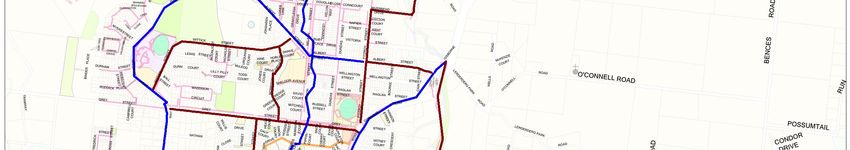
of a Hike and Bike Strategy and network for Moorabool Shire. The consultation completed
involved:

·      Resident Surveys
·      Engagement at the Council’s Health and Wellbeing Expo
·      Consultation workshop/meeting with Bacchus Marsh and District Trails Advisory
       Committee
·      Public Submissions process including an invitation to all Reserve Committees of
       Management to identify actions for the development of a Strategy
·      Key Stakeholder Consultation

1.4 Future Hike and Bike Strategy Direction

The vision for the Hike and Bike Network in Moorabool is:

    “To develop a safe and sustainable hike and bike network that provides for a wide range of
       users; provides safe local and regional connections between townships; and increases
                    recreation and tourism opportunities within Moorabool Shire”.

The draft strategy outlines a program of capital works and projects to support the growth and
utilisation of the Moorabool Hike and Bike Network. Recommendations have been listed and
categorised (in section five of the report) as Primary (Shared path network, strategic linkages),
Secondary (link destination points off the primary linkages including public transport routes)
and Local (creating linkages toward primary network).

It is recommended that priority for development of the hike and bike network be given to
linking primary destinations such as schools, larger shopping centres, major parks and
reserves, major public transport routes and significant community hubs and/facilities.

It is acknowledged however that all recommendations require prioritisation consistent with
Council’s Capital Works Evaluation Guidelines to determine the action plan for
implementation. Timeframe for delivery will also be driven by funding committed toward
these categorised recommendations as part of Council’s budget process.

Key recommendations detailed within the strategy are:

Planning and Policy Development

·      That all future strategic planning consider the future development and benefit of the hike
       and bike network.
·      That all future planning and implementation consider Council’s adopted Infrastructure
       Design Manual (IDM) that drives the infrastructure standards for the Shire.

Management and Maintenance of the Hike and Bike Network

·      Develop a process to ensure all existing and proposed paths (on road and off road) are
       documented and mapped using Council’s GIS system.
·      Ensure the budget allocation for maintenance of paths is also increased as new paths are
       developed.

Pedestrian Network

Moorabool Hike and Bike Strategy Draft Report FINALJUNE.docx (VIC 46.2012) - 10 June 2014   Page ii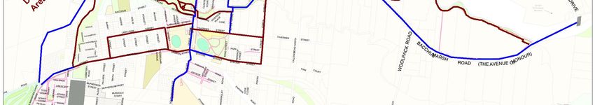
·      Priority for development of the hike and bike network is to be given to linking primary
       destinations such as schools, larger shopping centres, major parks and reserves, major
       public transport routes and significant community hubs and/facilities.
·      That the Pedestrian Path Priority Criteria outlined in Table 4.1 are used to assist with
       determining future pedestrian path priorities in the Shire.

Future Trail / Infrastructure Standards and Amenities

·      That all future hike and bike strategy development and implementation is implemented
       consistent with Council’s Infrastructure Design Manual to ensure a consistent standard is
       implemented across the Shire.

Promotion and Marketing

·      That Council develop a signage and promotional strategy for the Moorabool Hike and
       Bike network.
·      Ensure a hike and bike network map is available on Council’s website and it is updated
       annually.
·      Produce and regularly update a walking and cycling brochure of the available routes
       within the Moorabool Shire.
·      Publicise the hike and bike network through the Bacchus Marsh and District Tourist
       Information Centre.
·      Promote health and wellbeing through the promotion of walking routes using
       brochures/maps, signage and school and community promotion and events.
·      Work in partnership with other organisations such as the neighbourhood houses and
       community health centres to establish new community-walking groups and sustain
       existing groups.
·      Encourage local schools to establish walking (and potentially riding) school buses.

Emergency Services Telecommunication Authority (ESTA)

·        That ESTA signage is installed in all future trail development and along the Werribee
         and Lerderderg River trails where defining the exact location can be difficult.

Recreational / Paths / Tracks / Roads

·      That a feasibility study is undertaken to determine the viability and cost of developing the
       Avenue of Honour Heritage Trail.
·      That Council support the further development of tracks and trails along the Werribee River
       and Lerderderg River by the Parks Victoria.
·      That consideration is given to providing shoulders on selected roads between Gordon
       and Ballan and Ballan Daylesford to encourage and increase cycling safety.
·      That where cyclists regularly use secondary roads, signage-alerting motorists to the likely
       presence of cyclists in the area are considered for installation.

1.5 Funding and Grant Opportunities

The planned growth in Moorabool Shire provides an opportunity to further develop the hike
and bike network. Council will prioritise any opportunity for funding consideration through the
annual Capital Improvement Program with external grant opportunities also pursued to
support the funding model.

Mapping of the following townships is provided within the strategy outlining key hike and bike

Moorabool Hike and Bike Strategy Draft Report FINALJUNE.docx (VIC 46.2012) - 10 June 2014   Page iii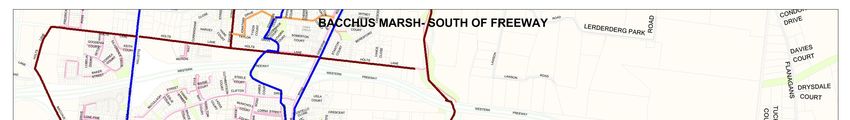
network priorities consistent with the principles and objectives of the draft strategy.

            ·      Bacchus Marsh                                                            ·   Greendale
            ·      Ballan                                                                   ·   Hopetoun Park
            ·      Blackwood                                                                ·   Lal Lal
            ·      Bungaree                                                                 ·   Long Forrest
            ·      Dunnstown                                                                ·   Mt Egerton
            ·      Elaine                                                                   ·   Myrniong
            ·      Gordon                                                                   ·   Wallace

Following review of the draft strategy including further community consultation a final strategy
document will be prepared.

Moorabool Hike and Bike Strategy Draft Report FINALJUNE.docx (VIC 46.2012) - 10 June 2014                       Page iv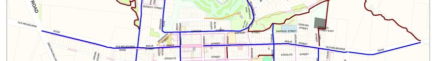
1              INTRODUCTION
Walking and cycling are two of the most popular activities undertaken by Australians and this
is no different for Moorabool Shire residents. The provision of infrastructure and programs to
support these activities significantly contributes to the health and wellbeing of the Moorabool
Community.

The “Hike and Bike Strategy” provides strategic direction for ongoing planning and
development of the hike and bike network throughout the Shire. The strategy will guide
Council in its decision making for the future development, provision, management,
maintenance, community education and marketing of hike and bike networks to support
both the recreation and transport needs of Moorabool Shire residents and visitors to the area.

1.1 PROJECT OBJECTIVES

The project objectives were to:

·      Develop a strategic plan to guide the future development of Council’s hike and bike
       network.

·      Research and identify the needs and expectations of the community using a range of
       consultative measures.

·      Identify the network in four main categories:
       · Commuter walk
       · Commuter cycle
       · Recreation walk
       · Recreation cycle

·      Prioritise further development of the hike and bike path network within the municipality
       with development of an action list identifying key works and rationale for inclusion.

·      Recommend future funding opportunities for proposed improvement works and
       programs.

1.2 PROJECT METHODOLOGY

The following methodology was adopted for the preparation of the plan and at the draft
report stage, SGL has completed tasks 1 to11.

·      Task 1: Project clarification
·      Task 2: Review of previous research and documentation
·      Task 3: Council Officer workshop
·      Task 4: Meeting with Track and Trails Committee
·      Task 5: Stakeholder Interviews
·      Task 6: Trails inspection
·      Task 7: Resident survey and public submission
·      Task 8: Discussion paper
·      Task 9: Area Mapping
·      Task 10: Strategy development
·      Task 11: Draft Strategy Report completed
·      Task 12: Public consultation on Draft Strategy Report
·      Task 13: Completion of Final “Hike and Bike Strategy Report”

Moorabool Hike and Bike Strategy Draft Report FINALJUNE.docx (VIC 46.2012) - 10 June 2014   Page 1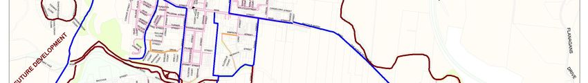
1.3 OVERVIEW OF MOORABOOL SHIRE

The Moorabool Shire’s landscape provides an array of living options. Residents can enjoy an
urban lifestyle in towns like Bacchus Marsh (45km west of the Melbourne CBD) and Ballan
(70km west of the Melbourne CBD) or take advantage of Moorabool’s small towns and
hamlets, rural open spaces and natural surrounds. A stunning Shire spanning more than 2,110
square kilometres, Moorabool is made up of 64 localities, hamlets and towns. More than 74%
of the Shire comprises of water catchments, state forests and national parks. Moorabool
boasts breathtaking landscapes, national parks, forests, gorges, mineral springs and tourism
attractions. Some of its key attractions include the Wombat State Forest, Brisbane Ranges
National Park, Lerderderg State Park, Werribee Gorge State Park and the Bacchus Marsh
Avenue of Honour.

Moorabool Shire is positioned along the major road and rail transport corridors between
Melbourne and Adelaide. Moorabool’s eastern boundary is located just 40km west of
Melbourne’s CBD and extends westwards to the City of Ballarat municipal boundary. The
Shire straddles Victoria’s Western Highway and has excellent transport access to Melbourne,
Ballarat and Geelong. Bacchus Marsh is equi-distant to Melbourne and Avalon airports and
close to the sea ports of Geelong and Melbourne.

1.4 THE BENEFITS OF WALKING AND CYCLING

The development of a “Hike and Bike” Strategy for Moorabool Shire will assist Council in
increasing the benefits to residents and area visitors that are gained through their ongoing
participation in walking and cycling.

There are many social, environmental and economic benefits associated with walking and
cycling that can be realised through the ongoing development of a high use walking and
cycling network including:

Social benefits:

·      Improved health and wellbeing through participation in physical exercise

·      Socially connected neighbourhoods

·      Independent and affordable means of travel

Environmental benefits:

·      Reduced use of vehicles particularly for short journeys

·      Reduced traffic congestion

·      Reduced use of fossil fuels

·      Improved air quality through less emissions from vehicles

Economic benefits:

·      Increased tourism opportunities within the Shire

Moorabool Hike and Bike Strategy Draft Report FINALJUNE.docx (VIC 46.2012) - 10 June 2014   Page 2
1.5 PARTICIPATION IN WALKING AND CYCLING

In order to understand the significance of the impact that improved walking and cycling
infrastructure can have on people’s health and wellbeing it is important to recognise the
existing high levels of participation in both activities across Australia.

The Exercise, Recreation and Sport Survey (ERASS) is a national survey undertaken by the
Australian Sports Commission which collects information on the frequency, duration, nature
and type of physical activities participated in for exercise, recreation or sport by persons
aged 15 years and over. The survey was conducted quarterly in 2010 with an annual total of
21,603 respondents across Australia.

The top ten physical activities in 2010 in terms of total participation rate were walking,
aerobics/fitness, swimming, cycling, running, golf, tennis, bushwalking, outdoor football and
netball.

An estimated 6.3 million persons or 35.9 per cent of the country’s population participated at
least once in walking for exercise, recreation or sport in 2010.

Over the last ten years participation in running, outdoor football, cycling and walking
increased, although walking, running and cycling showed greater fluctuation over the period
as can be seen in the results in the Table 1.1 below.

Table 1.1 shows participation levels by males and females in Victoria. This table clearly shows
that walking is the most popular activity for both sexes with participation by 46.1 per cent of
females compared to 26.8 per cent of males.

                                                                      Table 1.1
                                                          Top Ten Physical Activities Victoria

                                                    Male                                                        Female
                                                                           Total                                             Total
                                                                       Participation                                     Participation
                                Activity                                 Rate %                      Activity              Rate %
               Walking                                                         26.8         Walking                          46.1
               Aerobics/fitness                                                19.4         Aerobics/fitness                 29.8
               Cycling                                                         16.9         Swimming                         14.4
               Running                                                         14.9         Running                          10.5
               Swimming                                                        12.6         Cycling                          8.6
               Golf                                                            12.2         Yoga                             7.4
               Australian rules football                                       10.2         Netball                          6.7
               Tennis                                                           7.4         Tennis                           6.2
               Basketball                                                       6.7         Bushwalking                      4.2
               Cricket (outdoor)                                                6.6         Dancing                          3.5

Moorabool Hike and Bike Strategy Draft Report FINALJUNE.docx (VIC 46.2012) - 10 June 2014                                                Page 3
1.5.1 Relevant Findings from the National Cycling Participation Survey 2011
The National Cycling Participation Survey records the participation levels in cycling and key
trends.
1. National Trends
· In a typical week around 18 per cent of Australians ride a bicycle for transport and
recreation.
· More than 3.6 million people ride for recreation, leisure or sport.
· More than 1.2 million people make at least one transport journey by bicycle each week.
This includes trips to school, university, work, shops and to visit friends and family.
· The Northern Territory, ACT and Western Australia have cycling participation rates
significantly higher than the national average. Victoria is forth highest with 19.4 per cent of
the population riding in a typical week.
· Children have the highest levels of cycling participation:
o With nearly 50% of all 2 to 4 year olds
o With nearly 75% of all 5 to 9 year olds, and
o With nearly 33% of all 10 to 17 year olds ride a bicycle in a typical week.
· Men and boys (22%) are more likely to ride a bicycle than women and girls (13%) in a
typical week.
· The gender participation difference is smallest for children under 10 years of age.
All States and territories have seen a dramatic decrease in participation in these activities in
adulthood. This is especially marked in people aged 40 and over.
2. Victorian Trends
· Victorian cycling participation is similar to the Australian average.
· Around 19 per cent of Victorian residents ride in a typical week, increasing to 29 per cent
in a month and 42 per cent over a year.
· Cycling participation is significantly higher amongst residents of regional Victoria than in
metropolitan Melbourne.
· About half of all children aged under 10 ride each week, decreasing to 9 per cent of
those aged 40 and over.
· Victoria is the only jurisdiction in Australia where the participation rate of females is higher
than males in any age group.
· In Victoria more girls than boys aged under 10, ride a bicycle each week.
· In older age groups the gender balance returns to average. Overall about 23 per cent of
males and 16 per cent of females ride in a typical week. The lowest rate of participation
is by older women with 6 per cent of women aged 40 and over cycling in a typical week.
· Metropolitan Melbourne has a high proportion of people who cycle for transport (45% of
people who cycle in a typical week). About 367,000 people cycle for transport on at
least one occasion a week in Victoria.
· Just under two thirds of households in Victoria have access to a bicycle.
Moorabool Hike and Bike Strategy Draft Report FINALJUNE.docx (VIC 46.2012) - 10 June 2014 Page 41.6 KEY ORGANISATIONS THAT SUPPORT CYCLING
The following section summarises a range of key organisations that currently provide services
or support to cyclists and who impact on cycling participation.
1.6.1 Cycling Victoria
Cycling Victoria (CV) is the peak governing body for both organised competitive, and
recreational, cycling within Victoria, Australia.
CV has 8,000 members and 18,000 participants in CV programs and strives to improve
participation in cycling by coordinating a range of development programs for junior and
adult cyclists through the delivery of the Austcycle program throughout Victoria.
Membership has grown by 15 per cent over the last three years and more than tripled from
the three years previously.
CV works with cyclists on three levels.
· Competitive: Coordinates the competitive disciplines of road and track cycling at a club
and State level.
· Recreational: Provides options for recreational cyclists including the provision of insurance
coverage, and providing a calendar of recreational events.
· Development: Coordinates Coaching & Officials Courses, junior development camps,
school clinics, plus Come N Try road and track cycling days.
1.6.2 AustCycle
AustCycle is Australia’s only national cycling accreditation program, which provides high
quality education and training to community members to encourage them to get on their
bikes and ride. Whether for commuting purposes, for leisure or travel, AustCycle trains people
of all ages and backgrounds to incorporate cycling into their lifestyle in order to stay active
and healthy.
1.6.3 Bicycle Network Victoria
Bicycle Network Victoria (BNV), is a charity that promotes the health of the community by
“More People Cycling More Often”. Of the 50,000 members of BNV, 1,100 are from
Moorabool indicating a high level of interest in cycling.
BNV aims to achieve an increase in the number of people riding each week by 1,000,000
people by 2019 through the use of the following strategies:
1. Improving the riding environment through better facilities and legislation.
2. Delivering large-scale, measurable, cost-effective behaviour change programs.
3. Managing a range of rider services that reach out to potential riders and support novice
and established riders.
4. Running major events.
Moorabool Hike and Bike Strategy Draft Report FINALJUNE.docx (VIC 46.2012) - 10 June 2014 Page 51.6.4 Victoria Walks
Victoria Walks is a walking health promotion charity, managed by an independent voluntary
board with a mission to have more people walking every day. Their vision is for vibrant,
supportive and strong neighbourhoods and communities where people can and choose to
walk wherever possible.
Victoria Walks is a voting member of the International Federation of Pedestrians (IFP) which is
the umbrella organization for national pedestrian advocacy groups, and is a signatory of the
International Charter for Walking. Victoria Walks has been invited onto a number of key
Government advisory committees and reference groups relevant to creating walkable
communities and increasing the health of Victorians.
1.6.5 The Heart Foundation
The Heart Foundation is a charity that is dedicated to saving lives by making a difference to
the heart health of all Australians. The Heart Foundation help to fund vital research, develop
guidelines for health professionals, support patient care and help Australians to live healthier
lifestyles. They support and work with all levels of government, health organisations, the media
and community groups to implement policies and programs that improve the heart health of
all Australians and promote an active lifestyle. The Heart Foundation supports local
governments that change neighbourhoods to create healthier communities. Introducing
cycle ways, upgrading walking paths and promoting walking groups are just a few of
examples of recent initiatives they have supported. They promote the need for communities
to have access to a network of connected, direct and easy active travel routes which are
safe, comfortable, attractive and well-maintained, linking homes, shops, schools, parks, public
transport interchanges, green spaces and other important destinations.
1.7 REVIEW OF PREVIOUS RELEVANT RESEARCH
The following plans and policies have supported or identified the need to increase the level
of walking and cycling opportunities within the municipality.
· Moorabool Shire Council Plan 2013-2017
· Moorabool Shire Public Health and Well Being Plan 2013
· Moorabool Strategic Bicycle Plan 2001
· Bacchus Marsh District –Trails Master Plan 2004-2005
· Positive Ageing Strategy 2008
· Municipal Early Years Plan 2006-2009
· Front SEEAT (Social Employment Education Access Transport) Strategic Plan 2011-2013
· Planning Checklist for Cycling
· Moorabool Shire Recreation and Open Space Plan 2007 (currently being reviewed)
· Moorabool 2041 Urban and Rural Policies
· Bacchus Marsh Activity Centre Structure Plan
· Gordon Structure Plan
· Ballan Structure Plan
A synopsis of each policy and plan above and its relevance to the Hike and Bike Strategy
can be found in Appendix 5. Whilst all of the above documents informed the strategy, a
synopsis of the most relevant report appears below.
1.7.1 Moorabool Shire Recreation and Open Space Strategy 2007
This strategy helped identify that Council’s recreation resources in the past focussed primarily
on more traditional sporting activities and less on unstructured recreation such as walking,
Moorabool Hike and Bike Strategy Draft Report FINALJUNE.docx (VIC 46.2012) - 10 June 2014 Page 6bike riding, and sporting activities that are not undertaken within a club or competition
framework. The following recommendations are relevant to the Hike and Bike Strategy.
Recommendation 2.5
· Promote the establishment of walking groups.
Recommendation 3.3
· Develop a Signage Policy for recreation and open space areas.
Recommendation 5.9
· Prepare an integrated Footpath and Trail Strategy that forms part of the Asset
Management Plans for pathways.
· Implement the Bacchus Marsh and District Trails Master Plan (2004-2005) with input from
the Bacchus Marsh and District Trails Advisory Committee.
This strategy is currently being reviewed and new strategy will support the outcomes of this
Hike and Bike Strategy.
1.7.2 Moorabool 2041
Moorabool 2041 (M2041) is a Moorabool Shire Council adopted framework which at is heart
seeks to provide a vision for the type of community Moorabool Shire will be in 2041. To do so,
M2041 is to facilitate an outcome that both allows for growth and keeps the community
connectedness, character and sense of place so valued by our current residents.
It has two core elements, a rural growth strategy which seeks to develop a strategy for each
of the smaller settlements across the Shire, including Ballan. Where possible, scope to asset
share and cluster community services is a priority but there is also an imperative to foster
resilient communities, encourage growth, service offer and provide a sustainable base for
these towns.
The urban growth strategy is focused on Bacchus Marsh (including Darley and Maddingley),
the commercial and settlement centre of the Shire with over 15,000 residents (2011 census)
and expected to almost double by 2036. Given the growth expected, planning and
managing the pressures of growth in a proactive manner is necessary so that a sustainable
environment where people can live, work, access retail, social and recreational services and
be involved and connected. The strategy looks at what our future population will be and
what employment, services and infrastructure will be required to meet their needs so that
Council can identify what growth options will meet these needs in a sustainable and cost
effective manner.
M2041 is an identified project in Council’s Council Plan 2013-2017.
Moorabool Hike and Bike Strategy Draft Report FINALJUNE.docx (VIC 46.2012) - 10 June 2014 Page 72 OVERVIEW OF CONSULTATION
A range of community engagement and consultation was undertaken by SGL in order to
identify community perspectives on current issues and priorities in relation to the development
of a Hike and Bike Strategy and network for Moorabool Shire. The consultation completed
involved:
· Resident Surveys
· Engagement at the Council’s Health and Wellbeing Expo
· Consultation workshop/meeting with Bacchus Marsh and District Trails Advisory
Committee
· Public Submissions process including an invitation to all Reserve Committees of
Management to identify actions for the development of a Strategy
· Key Stakeholder Consultation
· Draft Strategy public exhibition engagement process for 10 week period
2.1 RESIDENT SURVEY KEY FINDINGS SUMMARY
A “Hike and Bike Resident Survey” was made available to the community via Councils online
engagement portal - Have Your Say” on 5 November 2012 through to 7 December 2013. The
aim of the survey was to gain community feedback that would assist in the development of
the draft Moorabool Hike and Bike Strategy.
At the completion of the survey period, 138 people visited the site a total of 201 times.
Full analysis of the survey is included in Appendix 1 of this report. Below is a summary of the
key findings from the survey results.
2.1.1 Residents Survey Key Findings Summary
· Of the survey respondents (58.6%) were female and (41.4%) were male.
· The majority of respondents were in the 21-50 years age group with 58.6 per cent of
respondents fitting into this age cohort. The next main group were the 51-65 years
· The highest priority action for council to encourage walking and cycling was to provide
safe paths/track to primary destinations such as shopping areas and community facilities
(66.7% supported) followed by the need for improved signage for existing routes.
· The greatest barrier to walking and cycling was identified as the lack of tracks/path by
65.5 per cent of respondents followed by 55.2 per cent who consider there is no safe
route to where they want to go.
· A total 56 per cent of respondents think that recreational paths should be funded ahead
of commuter routes.
· Half of the respondents (50%) walk for fitness, (41.7%) for recreation/fun; and (8.3%) of
respondents walk to commute to school/work.
Within the general comments received, many residents identified specific actions/routes,
which Council could take to improve walking and cycling opportunities in Moorabool.
Where possible these have informed the identification of specific actions for each township
for consideration by Council.
Moorabool Hike and Bike Strategy Draft Report FINALJUNE.docx (VIC 46.2012) - 10 June 2014 Page 82.2 HEALTH AND WELLBEING EXPO
Moorabool Shire Council ran a Health and Wellbeing Expo on 10th November in 2012. As part
of the expo, a series of consultation methods were used to obtain residents thoughts in regard
to health and wellbeing. One of the opportunities available to residents was to place their
ideas in a “Wish box.”
The key theme to emerge from the wish box was the desire of residents for better facilities,
opportunities and connections for walking and cycling. The feedback supported the need to
increase and improve infrastructure, planning and information for walking and cycling in
Moorabool.
2.3 BACCHUS MARSH AND DISTRICT TRACKS AND TRAILS COMMITTEE (BMDTAC)
The consultant and Council officers attended a meeting with the BMDTAC to identify key
issues and priority projects for the ongoing development of a trail network in the Bacchus
Marsh and District Area.
Listed in Appendix 2 is a table outlining the key priorities for the BMTAC as at 2009. It should
be noted that Priority 3 and 6 have been completed since this list was formed.
Appendix 3 lists a number of main trail routes which BMDTAC have proposed for linking key
areas within Bacchus Marsh with the aim being to identify the key routes to link the various
residential areas with the town centre, schools and recreational reserves. Further consultation
has been conducted with the BMDTAC in regard to specific routes suggested and are
covered in the action plans in section five.
2.3.1 Key Issues Identified by BMDTAC
The key issues identified by the BMDTAC group as main barriers to walking/cycling in the
Bacchus Marsh and District Areas were:
· A lack of safe cycle link running north south through Bacchus Marsh.
· The pedestrian Refuge near the outdoor swimming pool in the middle of Grant Street
needs to be made more permanent.
· Extension of the existing path along Griffith Street to connect with Halletts Way
· Connection between Comets Way to Halletts Way to Links Road
· Crossing Taverner Street from Boyde Close
· Connecting Maddingley Park to Bennet Street.
· Connecting Greenway from Bacchus Marsh Activity Centre
· Lack of safe and accessible crossing to provide a circuit path within Peppertree Park
· Pedestrian access to the Avenue of Honour.
2.4 GREAT DIVIDING TRAIL COMMITTEE
The Great Dividing Trail Committee has identified a trail through Moorabool with the
recommended pathways also being identified through the BMDTAC proposed routes. This
trail is regionally significant and effective signage needs to be maintained to facilitate use of
the trail.
Moorabool Hike and Bike Strategy Draft Report FINALJUNE.docx (VIC 46.2012) - 10 June 2014 Page 92.5 GENERAL COMMUNITY CONSULTATION
Community groups and residents were invited to contact the project consultant directly
regarding the development of the Hike and Bike Strategy. All Recreation Reserve
Committees across the Shire were invited to contribute information and ideas to the
development of the Hike and Bike Strategy. The following contributions and comments were
received.
2.5.1 Myrniong Recreation Reserve Committee of Management
· The community is interested in developing a track from the Recreation Reserve to the
School.
· The establishment of a bike club for Moorabool would also be of interest.
· Bacchus Marsh could be promoted as a bike friendly town.
2.5.2 Elaine Recreation Reserve Committee of Management
· A path is required from the Recreation Reserve to the CFA building along Midland Hwy.
2.5.3 Wallace Recreation Reserve Committee of Management
· Actions from the Reserve Master Plan should be incorporated into the Hike and Bike
Strategy.
2.5.4 Bacchus Marsh Tourism Association - Avenue of Honour Heritage Trail
· There is strong interest in developing a Heritage Trail, which includes the Avenue of
Honour and other areas of historic interest.
· This project involves developing a 3.5 kilometre accessible walking trail that links Bacchus
Marsh township with the full length of the Avenue of Honour, through to Moon Reserve,
then across the highway via a pedestrian overpass (would need to be constructed) with
the trail then continuing to Hopetoun Cemetery and Ta Pinu.
· This project was submitted for funding under Council’s Community Development Fund
2011/2012 and was supported for further scoping of the feasibility of the concept.
· The project would benefit local residents who have expressed interest in recreational and
tourism trails as well as increasing tourism product to attract people to visit.
2.5.5 Ballan Resident 1 – Telephone Consultation
· “There are no safe riding or running tracks in Ballan. As a triathlete, I have to run on the
road to ensure a consistent and connected surface.”
· “A number of existing tracks are in disrepair and are not safe e.g. the track near the
Werribee River is not long enough and is in disrepair.”
· “It would be beneficial if signs were erected on roads frequented by cyclists to
encourage motorists to be aware of cyclists in the area. Suggested roads include,
Ballarat to Gordon, Ballan to Gordon, Anakie Road to Daylesford Road.”
The trails referenced above were damaged by flood at the time of this consultation and
works undertaken to address since that time.
2.5.6 Ballan Resident 2 – via email
Moorabool Hike and Bike Strategy Draft Report FINALJUNE.docx (VIC 46.2012) - 10 June 2014 Page 10· “When are we going to get some decent walking tracks? We have Caledonian Park,
which is beautiful but completely impractical as it is not possible to do a complete
circuit.”
· “One can only walk so far and then you have to turn and come back the same way, as it
is not possible to cross the river.”
· “It seems crazy that we live in a beautiful area but we cannot take advantage of it. We
have very limited resources to exercise and stay healthy - no gym, a pool that is only open
in summer, no walking tracks.”
Moorabool Hike and Bike Strategy Draft Report FINALJUNE.docx (VIC 46.2012) - 10 June 2014 Page 113 KEY ISSUES AND OPPORTUNITIES
This section identifies the key issues raised from the range of research and consultation
processes in the development of the draft Hike and Bike Strategy for Moorabool Shire
Council.
3.1 KEY ISSUES
The work to date has identified the following key issues:
1. There are many streets within the townships of Bacchus Marsh, Ballan and surrounds
without footpaths partly due to non-linked housing developments, which in the past have
not been required to provide footpaths.
2. Lack of continuity and connection with footpaths within townships.
3. The current lack of connection between new housing developments and the town
centres of Bacchus Marsh and Ballan.
4. The lack of a safe north/south cycling route in Bacchus Marsh Township.
5. No safe crossing point under the Western Highway as the underpass is currently locked at
night.
6. Maintenance of existing tracks.
7. Lack of signage for existing tracks.
8. Limited awareness by the community of existing tracks.
9. Limited/no lighting along some existing paths.
10. Limited shoulders on roads connecting townships making cycling hazardous.
11. Lack of signage on roads used by cyclists between townships e.g. Ballan to Gordon.
12. Limited financial capacity of Council to develop and maintain new paths and trails
throughout the Shire.
3.1.1 Options to Address North South Access through Bacchus Marsh
There are three options raised for consideration to improve the north south trail access
through Bacchus Marsh
1. Widening of Gisborne Road to ensure development of a designated continuous bike lane
along Gisborne Road which is likely to require widening of the road (Gisborne Road is the
responsibility of Vic Roads). Although bike lanes are already provided, feedback from
users suggest they’re inadequate and not wide enough.
2. Development of pedestrian and cycle paths and pedestrian freeway crossing along
Halletts Way. It should be noted this freeway crossing is a VicRoads responsibility.
Moorabool Hike and Bike Strategy Draft Report FINALJUNE.docx (VIC 46.2012) - 10 June 2014 Page 123. Development of a pathway along the Irrigation Channel and easement between Werribee River and Lerderderg River. (Note: Southern Rural Water owns this land) Through the consultation phase, residents identified the development of a pedestrian bridge adjacent to the existing bridge on Halletts Way would increase accessibility at this location. This pedestrian crossing as previously mentioned is a responsibility of VicRoads. The continuation of Halletts Way connecting the north of Bacchus Marsh with the South has been identified in the Bacchus Marsh Structure Plan. It is anticipated to be between five and ten years before this is completed, with developer contributions and Council funding this project. The future development of the Halletts Way overpass would also significantly reduce the current dependency on Gisborne Road as the key access point into Bacchus Marsh The development of a pathway along the Irrigation Channel and easement land area between Werribee River and Lerderderg River was identified by BMDTAC and has been further explored through this project via discussions with Council Officers and Southern Rural Water.The following email response was received from Edward Smith, Manager Water Supply West following a discussion in relation to the possibility of developing a shared pathway along the irrigation supply channels: “The irrigation supply channels are currently fenced off for public safety reasons. Therefore we would not wish to see walking or cycling tracks alongside the channel. However we are looking into reconfiguring the irrigation district, which may mean we would pipe that section of the supply system. If this was to occur the channel easement could be used for such purposes. However, early indications are that this would cost in the region of $10m to $15m, which would be unviable to fund from our customer base, without some external funding. In addition to the cost to develop the channel there is also concern regarding the safety of this route as sections of the channel have no casual surveillance as residential properties back fences face the channel”. It is understood that the Board of Southern Rural Water has expressed interest in the proposal. Of the three options, Option 2, which is the development of Halletts Way, as the primary north south link across Bacchus Marsh appears to be the most viable and achievable with required works already identified within a local planning context. In addition accessing developer contribution funds for this purpose will reduce the full financial cost from Council. Any action that will speed up the delivery of this critical link should be considered a priority. Further investigation of the viability of other north south links including the irrigation channel is recommended as this is considered a high priority to be evaluated.. Moorabool Hike and Bike Strategy Draft Report FINALJUNE.docx (VIC 46.2012) - 10 June 2014 Page 13
4 MOORABOOL HIKE AND BIKE STRATEGIC DIRECTIONS
This section outlines the recommended future vision, principles and objectives of the draft
Moorabool Hike and Bike Strategy as well as proposed development guidelines, standards
and notional program of works to be undertaken, across the municipality, to improve the
opportunities for walking and cycling in Moorabool Shire Council.

4.1 MOORABOOL HIKE AND BIKE STRATEGY VISION

The vision for the Hike and Bike Network in Moorabool is:

“To develop a safe and sustainable hike and bike network that provides for a wide range of
users; provides safe local and regional connections between townships; and increases
recreation and tourism opportunities within Moorabool Shire”.

4.2 STRATEGY PRINCIPLES

The following principles have been developed to direct the Moorabool Hike and Bike
Strategy:

1. The provision of a Hike and Bike Network will provide increased walking and cycling
   opportunities that will support social interaction, enhance safety and reduce reliance on
   cars.

2. Tracks and trails provide active recreation opportunities to increase the health and
   wellbeing of the community.

3. Tracks and trails connect key community destinations such as schools, shopping centres,
   parks, reserves and other local places of interest to connect people to the town

4. A hike and bike network will be developed within key towns across Moorabool to foster
   effective access through the towns, connecting key access ways and community facility
   infrastructure. This will include the connection of key missing linkages to facilitate a more
   efficient network.

4.3 STRATEGY OBJECTIVES

·      To effectively guide the future development of Council’s hike and bike network for
       recreational and commuter walking and cycling.

·      To increase the physical activity levels of Moorabool residents through the provision of
       tracks and trails to primary community destinations such as schools, shopping centres,
       parks and reserves, medical practices, and natural attractions.

·      Provide track and trails that are safe and include passive surveillance wherever possible.

·      Increase the connectivity of existing tracks and trails throughout the Shire to enhance the
       usability and effectiveness of the network.

·      Prioritise network development opportunities to maximise the benefits of investment to the
       community and to support future funding opportunities and applications.

Moorabool Hike and Bike Strategy Draft Report FINALJUNE.docx (VIC 46.2012) - 10 June 2014   Page 14
4.4 MOORABOOL PLANNING SCHEME GUIDING DOCUMENTS
All approved Council precinct structure plans and Council policies must be considered in the
development of the future hike and bike network Relevant details have been summarised
from these documents and can be found listed in Appendix 4 of this document.
Key Recommendation
All Precinct Structure Plans and Council Policies will be considered, in the development of the
Hike and Bike Network.
4.5 MANAGEMENT AND MAINTENANCE OF THE HIKE AND BIKE NETWORK
Council has spent considerable time updating data on existing paths within Council’s GIS
system to develop a robust database that includes the condition of each path and trail and
provides Council with a clear picture on path upgrade and provision requirements.
Alongside the ongoing process of maintaining effective records is the need to ensure the
budget allocation for maintenance and inspection of paths is also increased in line with new
paths and trails being developed. This will ensure safety and provision standards are
maintained over the expanded trails network.
Key Recommendations
· Ensure all existing and proposed paths (on road and off road) are documented and
mapped using Council’s GIS system.
· Ensure the process for altering the status of paths (e.g. proposed to complete) is
undertaken including referral to the Asset Register.
· Ensure the budget allocation for maintenance of paths is also increased as new paths
are developed.
4.6 PEDESTRIAN PATH NETWORK
Recommendations for development of the hike and bike network will consider linking primary
destinations such as schools, larger shopping centres, major parks and reserves, major public
transport routes and significant community hubs and/facilities to increase connectivity and
promote health and wellbeing lifestyle opportunities.
Whilst a complete pedestrian path network is desirable, given the financial constraints faced
by Council, the criteria outlined below can be used to determine future recommendations
within this strategy. Prioritisation of these recommendations will then occur in accordance
with the Capital Works Evaluation Guidelines 2012.
Table 4.1
Pedestrian Path Recommendation Guiding Principles
Criteria Description
Proximity to Primary Destination Paths/sections of paths in close proximity to a primary
destination.
Expected Use Paths likely to serve higher numbers of pedestrians
Community Safety Pedestrian safety is critical. Issues impacting on safety
Moorabool Hike and Bike Strategy Draft Report FINALJUNE.docx (VIC 46.2012) - 10 June 2014 Page 15Criteria Description
include speed limit of adjacent traffic, and traffic volume.
Community Demand Where there is demonstrated community demand for the
route.
Cost/benefit construction of missing links and shorter sections of path, as
the completion of these will encourage walking.
Complexity of Works The type of terrain will impact the constructions and
ongoing lifecycle costs, consideration to those paths that
address significant public safety concerns.
Key Recommendation
· That the guiding principles outlined in Table 4.1 above are used to assist with
determining future pedestrian path recommendations identified in this strategy across
the Shire. All recommendations will be then evaluated as per Councils Capital Works
Evaluation Guidelines 2012.
4.7 FUTURE TRAIL/INFRASTRUCTURE STANDARDS AND AMENITIES
According to Austroads: “The purpose of a bicycle network is to enable cyclists of a wide
range of abilities and experience to move safely and conveniently to chosen destinations via
suitable desire lines. The basis of a bicycle network is the road network, augmented by
special on-road facilities together with dedicated infrastructure such as off-road paths, and
footpaths where permitted, and may include public transport”1.
VicRoads have developed a series of documents called “CycleNotes” which specify the
design standards for bicycle facilities. These standards should be read in conjunction with
Austroads Guide to Traffic Engineering Practice Part 14 – Bicycles and Australian Standard
1742.9 Manual of Uniform Traffic Control Devices Par 9 – Bicycle Facilities). These standards
should be used in the development of all future cycling infrastructure in Moorabool.
The Bicycle Network Victoria website provides a wealth of cycling related information and
planning documentation including “Cycle Notes” in relation to a range of planning and
infrastructure topics.
The Municipal Bike Network produced by VicRoads in 2005 for Bacchus Marsh shows existing
on road and off road routes though Bacchus Marsh.
Identified off road priorities yet to be constructed include:
· Station Street from the end of the railway Station to Fisken Street
· Fisken Street from Station Street to Taverner Street
Identified on road priorities yet to be constructed include:
· Main Street from Grant Street to the Avenue of Honour
· Gisborne Road from Grey Street to Albert Street
The following advice has been taken from the Bicycle Network Victoria Website.
“Paths for cyclists can be shared with people walking (shared paths) or bicycle only paths.
Paths need to be built wide enough to cater for the current and future number of users. The
accepted minimum width for shared paths is 2.5m, with paths expecting commuter traffic at
1 Austroads 2011
Moorabool Hike and Bike Strategy Draft Report FINALJUNE.docx (VIC 46.2012) - 10 June 2014 Page 16You can also read