New Tabulam bridge for Bruxner Highway - Transport Roads & Maritime Services - Roads and ...
←
→
Page content transcription
If your browser does not render page correctly, please read the page content below
Transport
                                Roads & Maritime
                                Services

New Tabulam bridge for
Bruxner Highway

Preferred Route Option Report
MAY 2014

                                ISBN 978-1-925093-62-9 RMS 14.196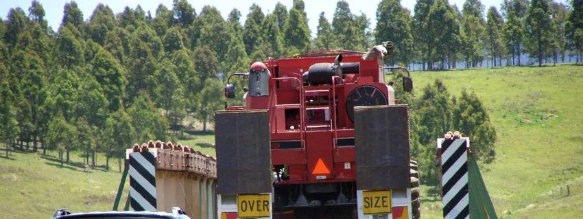
Executive summary
Introduction
Tabulam is in the Northern Rivers region of New South Wales, situated on the
Bruxner Highway (HW16), between Tenterfield and Casino, and located on the
Clarence River.
The existing Bruxner Highway bridge over the Clarence River at Tabulam, which is a
State heritage listed structure, is primarily a timber structure and has an overall
length of about 300 metres, comprising 13 timber approach spans and five composite
timber/steel de Burgh truss central spans. The overall width between kerbs is only
4.6 metres, accommodating only single lane traffic. The main spans are supported by
concrete piers located in the river, whilst the approaches are supported by timber
trestles.
Extensive maintenance works have been carried out over recent years to ensure the
bridge remains safe for legally loaded vehicles. However, the bridge presents
significant transport limitations both now and into the future and also requires a
disproportionate share of NSW Roads and Maritime Services (Roads and Maritime)
bridge maintenance funding.
Roads and Maritime is currently carrying out investigations for a new bridge over the
Clarence River and to remove the existing structure. The study area for the project is
located on the Bruxner Highway incorporating the village of Tabulam and the
Clarence River.
The process to identify a preferred route for the new Tabulam bridge project involves:
The development and assessment of the route options
Community and stakeholder consultation
Investigations of the study area
The identification and display of the preliminary route options for community
comment
Field investigations and technical studies
A value management workshop
The identification and display of a preferred route option.
Following the display of the preferred option, Roads and Maritime will prepare a
concept design and an environmental impact assessment (EIA) for further community
input. Issues raised by the community will be considered before project approval is
sought.
This report focuses on the development and display of the preferred route option.
Tabulam New Bridge iii
Preferred Route Report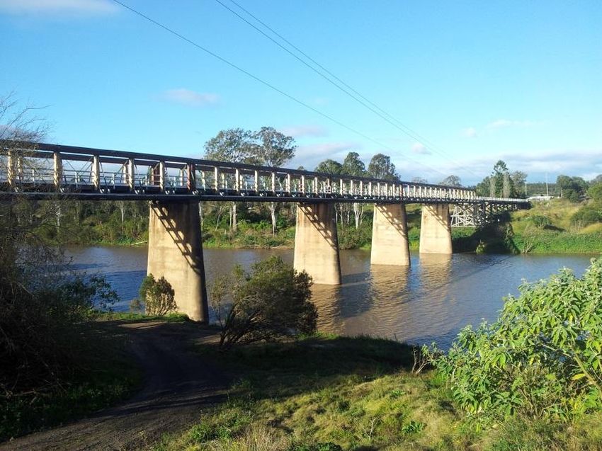
Project objectives
The project objectives are as follows:
Enhance road safety for all road users over the length of the project, including
improving safety for pedestrians and cyclists. Investigate and determine the
appropriate treatment for pedestrians and cyclists on the new structure
Remove the existing bridge
Improve traffic efficiency
Improve road transport productivity and reliability
Support regional and local economic development including improved
opportunity for economic and tourist development for Tabulam
Provide a value for money solution
Minimise impacts on the natural, social and built environment
Coordinate construction traffic to minimise its impact and damage to the
existing structure and to make allowance for potential maintenance works that
may need to be conducted during the course of this project
Involve all stakeholders and consider their interests
Consider constructability impacts
Consider Work Health and Safety impacts of the project options.
Strategic transport and planning context
A number of plans and strategies are referenced in this report that provides an
overview of the transport planning context for NSW and more locally the Bruxner
Highway. These are:
NSW Long Term Transport Master Plan
State Plan - NSW 2021
State Infrastructure Strategy
Ballina to Tenterfield Corridor Strategy.
Furthermore, two additional studies relate directly to the strategy of providing a new
bridge at Tabulam and demolishing the existing bridge. These are:
Timber Truss Bridge Conservation Strategy.
Bridges for the Bush.
Timber Truss Bridge Conservation Strategy
The Timber Truss Bridge Conservation Strategy was completed in July 2012. The
strategy was developed to address the long term management of timber truss
bridges in NSW. The strategy, carried out in consultation with the Heritage Council of
NSW, aims to establish a balance between infrastructure provision and heritage
conservation.
Tabulam New Bridge iv
Preferred Route Report
The strategy identified the existing bridge over the Clarence River at Tabulam as
requiring replacement and for the existing structure to be removed. It found that the
existing bridge could not be upgraded to meet current or future transport needs.
Furthermore, the strategy found that any form of retention of the bridge would
present continuing conservation, operational and financial challenges. The report
noted that conservation of the bridge would not substantially strengthen the
representative sample and would come at a high ongoing cost to government.
Bridges for the Bush
In October 2012 the NSW Government committed to improving road freight
productivity by replacing or upgrading bridges over the next five years at 17 key
locations in regional NSW.
One of the priority programs to help manage ageing assets and provide a benefit to
freight productivity includes the replacement of six heritage timber truss bridges to
modern standards, including the existing bridge over the Clarence River at Tabulam.
Community involvement
A community and stakeholder consultation strategy has been implemented since the
project began in May 2013. The local community has important information on issues
and constraints in the study area that has assisted in identifying a preferred route for
the new bridge.
Activities to date have included:
Announcement of the project and mail out to local residents and stakeholders
A staffed drop-in session in Tabulam following the announcement of the project
and study area
Announcement of the shortlisted route options and publication of a community
update
A staffed drop-in session in Tabulam following the announcement of the
shortlisted route options
Advertising and media coverage (print and electronic) informing the community
of key aspects of the project and opportunities for involvement
Provision of a free call community information line (1800 810 680) and email for
project inquiries - community.input@ghd.com
Meetings/briefings to local councils, Tabulam Chamber of Commerce and
special interest groups
Dedicated project webpages on the Roads and Maritime website
An Early Feedback Summary report following the display of the study area and
receipt of community feedback, which is available on the Roads and Maritime
project website
A Feedback Summary report following the display of the shortlisted route
options and receipt of community feedback
Community and stakeholder participation at the value management workshop,
providing input into the selection of a preferred route option for the project.
Tabulam New Bridge v
Preferred Route Report
The preferred route option, along with this report, will be placed on public display for
a period of four weeks and public comment invited.
Roads and Maritime will continue to work closely with the community throughout the
remainder of the project.
Community feedback and retention of the existing bridge
Roads and Maritime acknowledges there is some community opposition to the
removal of the existing bridge over the Clarence River at Tabulam. Roads and
Maritime has received this feedback verbally, in written form and via two community
petitions.
Options that were considered for retaining the existing bridge included:
Retain the existing bridge for pedestrian access only
Retain the bridge for visual aesthetics only until the bridge collapses into the
river
Retain the existing bridge for its current use.
This feedback has been carefully considered. However, due to ongoing conservation,
operational and financial challenges presented by retaining the existing bridge,
Roads and Maritime is proceeding with the current project. This includes identifying a
replacement bridge location and removal of the existing bridge.
Roads and Maritime is investigating ways to recognise the heritage significance of
the existing bridge and will work with the community to determine the most
appropriate ways that the bridge could be remembered. The community is
encouraged to continue to provide feedback and ideas.
Study area characteristics
To assist in the development of the preliminary route options a number of preliminary
desktop studies were carried out to understand the key characteristics within the
study area.
Findings from the studies were used to build constraint mapping across areas such
as socio-economic, environmental and engineering, which were used to assess the
potential impacts for each of the preliminary route options developed within the study
area.
Route options development
The route option development process includes several steps:
Review of existing data including reports, maps and other information available
Site familiarisation and site visits including inspections of road, bridges and
study area
Preliminary investigations and assessments to determine the opportunities and
constraints for route options
Development of preliminary route options
Shortlisting workshop to review and assess preliminary route options and
establish a shortlist of route options worthy of further development and
investigation
Route options development report and display
Tabulam New Bridge vi
Preferred Route Report
Onsite investigations including geotechnical investigations, flora and fauna
surveys, noise monitoring and Aboriginal heritage survey and consultation
Value management workshop for the selection of a preferred route option
Preferred route report and display – where we are now.
Selection of the shortlisted route options
A shortlisting workshop was held in August 2013 to evaluate eleven preliminary route
options against the project objectives and establish a shortlist of route options for
further development and investigation.
At the conclusion of the preliminary route option assessment process the following
route options were shortlisted for public display and further development and
investigation:
Option A - starts at the existing highway on the western approach, crossing the
river upstream and parallel to the existing bridge, then converges and re-joins
the highway at the Clarence Street intersection. This option uses only one of
the existing overflow bridges on the western side of the river
Option B - starts at the highway on the western approach, crossing the river
upstream and parallel (curved alignment) to the existing bridge, connecting to
the existing highway at the Clarence Street intersection. This option utilises
both overflow bridges on the western side of the river
Option C - starts at the existing highway on the western approach, crossing the
river downstream and parallel to the existing bridge, then converges and re-
joins the highway at the Clarence Street intersection. This option uses only one
of the existing overflow bridges on the western side of the river
Option D – starts at the existing highway at the most western overflow
structure, crossing the river downstream on a slight angle to the existing bridge,
then converges and re-joins the highway at the Clarence Street intersection.
This option uses only one of the existing overflow bridges on the western side
of the river.
A description of the preliminary option development and selection of the shortlisted
route options process is documented in the Route Option Development Report which
is available on the Roads and Maritime website.
Selection of the preferred route option
Shortly after the display of the four route options, additional onsite investigations
were carried out including geotechnical investigations, flora and fauna surveys, noise
monitoring and Aboriginal heritage survey and consultation.
Following the site investigations and analysis of community comment a value
management workshop was held in February 2014 to evaluate the four route options
using assessment criteria based on the project objectives.
A description of the value management workshop and process is documented in the
Value Management Workshop Report which is available on the Roads and Maritime
website.
Tabulam New Bridge vii
Preferred Route Report
Following the workshop and further investigation Option D has been identified as the
preferred option for the new Tabulam bridge as it would:
Have little or no impact on flora and fauna
Provide improved access to Clarence River Road and the pre-school
Be located away from the existing bridge, resulting in minimal traffic impacts
during construction
Not impact on known Aboriginal cultural heritage
Minimise private land acquisition
Have least impact on public utilities
Result in a better and safer horizontal and vertical alignment outcome
Provide the best value for money solution.
Next steps
Following the display of the preferred route option, Roads and Maritime will review
submissions received during the display period and consider them during the
development of the concept design and environmental assessment. A community
feedback report will be prepared to summarise the feedback received and published
on the Roads and Maritime website.
In addition, more detailed field investigations will be carried out for the preferred route
option corridor to assist the development of the concept design and environmental
impact assessment.
The concept design and environmental impact assessment will be displayed for
community comment.
Tabulam New Bridge viii
Preferred Route Report
Clarence River Road
Tabu lam Rivul et
Road
Clarence River Overflow
Bridge No 1
u lam
Tab
Cha
Stre rles
et
Exi
s ting
Bri
dge
Clarence River Overflow OPT
Bridge No 2 I ON
D
er
Clarence R iv Br
ux
n er
Hi
gh
wa
y
To Casino
eet
(Ballina)
S tr
Bru
E
nc e
x ner
E
Hig
re
h wa
Cla
y
To Tenterfield
t
tree
eS
enc
r
Law
Str ek
Gra
eet
ft
Stre on
Cre
et
o
LEGEND
0 15 30 60 90 120
Preferred Route Option
Preferred Route Option - Option D
Metres
Map Projection: Transverse Mercator
Horizontal Datum: GDA 1994
Grid: GDA 1994 MGA Zone 56
Tabulam New Bridge       x
Preferred Route Report
Contents
1   Introduction.......................................................................................................... 1
    1.1 Project overview ......................................................................................... 1
    1.2 Report purpose and structure ..................................................................... 3
    1.3 The need for the project .............................................................................. 3
    1.4 Project objectives........................................................................................ 3
    1.5 Project details ............................................................................................. 4
    1.6 The study area............................................................................................ 4
    1.7 Design requirements................................................................................... 6
    1.8 The planning process.................................................................................. 6
    1.9 Working papers........................................................................................... 8
2   Strategic transport and planning context.............................................................. 9
    2.1 Strategic transport and planning ................................................................. 9
    2.2 Higher Mass Limits (HML) vehicles ........................................................... 12
    2.3 Implications of doing nothing..................................................................... 12
3   Approach to the project ..................................................................................... 13
    3.1 Development of a long list of route options ............................................... 13
    3.2 Development of the shortlist of route options ............................................ 13
    3.3 Development and assessment of the preferred route ................................ 14
4   Characteristics of the study area and issues for route option development........ 15
    4.1 Overview of the study area ....................................................................... 15
    4.2 Existing highway ....................................................................................... 16
    4.3 Traffic and transportation characteristics................................................... 18
    4.4 Road safety .............................................................................................. 19
    4.5 Land use and planning issues................................................................... 20
    4.6 Heritage .................................................................................................... 26
    4.7 Visual amenity .......................................................................................... 30
    4.8 Noise, vibration and air quality .................................................................. 32
    4.9 Biodiversity ............................................................................................... 33
    4.10 Hydrology and hydraulics.......................................................................... 34
    4.11 Water quality............................................................................................. 36
    4.12 Geotechnical conditions ............................................................................ 36
    4.13 Public utilities ............................................................................................ 38
5   Route options .................................................................................................... 40
    5.1 Community input to route options.............................................................. 40
    5.2 Process for development of the route options ........................................... 41
    5.3 Development of the long list of route options ............................................ 41
    5.4 Selection of the shortlisted route options................................................... 45
    5.5 Short listed route options .......................................................................... 49
6   Consultation and value management workshop ................................................ 52
    6.1 Public display activities ............................................................................. 52
    6.2 Value management workshop................................................................... 56

Tabulam New Bridge                                                                                                       xi
Preferred Route Report
7 Selection of the preferred route ......................................................................... 63
7.1 Overview of process to date...................................................................... 63
7.2 Value management workshop outcome .................................................... 63
7.3 Investigations following the value management workshop ........................ 63
7.4 Technical group option assessment workshop .......................................... 64
7.5 The preferred route ................................................................................... 64
7.6 Reasons why the preferred route was selected......................................... 65
8 The preferred route............................................................................................ 66
8.1 Overview................................................................................................... 66
8.2 Benefits of the preferred route .................................................................. 66
8.3 Potential impacts of the preferred route .................................................... 68
9 The next steps ................................................................................................... 70
10 References ................................................................................................... 71
Tables
Table 1-1 Project details ...................................................................................... 4
Table 1-2 Geometric performance and design requirements ................................ 6
Table 4-1 Average daily traffic volumes for Tabulam Bridge............................... 19
Table 4-2 LEP zone objectives and provisions ................................................... 21
Table 5-1 Assessment criteria and weightings ................................................... 45
Table 5-2 Initial evaluation results ...................................................................... 47
Table 5-3 Preliminary route option evaluation results ......................................... 48
Table 5-4 Strategic cost estimates for shortlisted route options.......................... 50
Table 6-1 Summary of benefits and challenges raised by the community .......... 53
Table 6-2 Assessment ranking and strategic cost estimates .............................. 61
Figures
Figure 1-1 Locality sketch ..................................................................................... 2
Figure 1-2 Study area ........................................................................................... 5
Figure 2-1 View to the west of traffic crossing the Tabulam Bridge ..................... 11
Figure 4-1 Existing bridge over the Clarence River at Tabulam – view east ........ 17
Figure 4-2 Existing Clarence River Overflow bridges .......................................... 17
Figure 4-3 Land Use and Planning ...................................................................... 25
Figure 4-4 Aboriginal sites and predictive mapping ............................................. 27
Figure 4-5 Non-Aboriginal heritage...................................................................... 29
Figure 4-6 Landscape character zones ............................................................... 31
Figure 4-7 Flooding 100 yr ARI ........................................................................... 35
Figure 4-8 Geotechnical ...................................................................................... 37
Tabulam New Bridge xii
Preferred Route ReportFigure 4-9 Utilities ............................................................................................... 39 Figure 5-1 All Route Options ............................................................................... 44 Figure 5-2 Shortlisted options.............................................................................. 51 Figure 6-1 Plan view of possible bridge approach treatment ............................... 55 Figure 6-2 Perspective view of possible bridge approach treatment .................... 56 Figure 8-1 Preferred route option ........................................................................ 67 Tabulam New Bridge xiii Preferred Route Report
Tabulam New Bridge       xiv
Preferred Route Report
1 Introduction
This chapter provides an overview of the project details, the study area and project
objectives. It also describes the purpose and need for the project along with the
planning process and working papers produced to date.
1.1 Project overview
Tabulam is in the Northern Rivers region of New South Wales and is situated on the
Bruxner Highway (HW16), between Tenterfield and Casino. Located on the Clarence
River, its position on the northern catchment of one of Australia’s largest rivers
affords it geographical and environmental significance.
Originally occupied by the Bundjalung people, Tabulam and surrounding land was
first settled by Europeans in 1839. A postal service from Grafton was established in
1848 and eventually a courthouse and post office opened in 1849. The river crossing
remained a problem with many sheep-droving teams stranded when the river
flooded. The existing bridge was built in 1903, though a punt had aided river
crossings as early as 1863. As such the heritage of the town is an important
consideration when planning for a new bridge over the Clarence River.
A map of Tabulam and its location in northern NSW is provided as Figure 1-1.
The existing Bruxner Highway bridge over the Clarence River at Tabulam, which is a
State heritage listed structure, is primarily a timber structure and has an overall
length of about 300 metres, comprising 13 timber approach spans and five composite
timber/steel de Burgh truss central spans. The overall width between kerbs is 4.6
metres, accommodating single lane traffic only. The main spans are supported by
concrete piers located in the river, whilst the approaches are supported by timber
trestles.
Extensive maintenance works have been carried out over recent years to ensure the
bridge remains safe for legally loaded vehicles. However, the bridge presents
significant transport limitations both now and into the future and also requires a
disproportionate share of NSW Roads and Maritime Services (Roads and Maritime)
bridge maintenance funding.
Roads and Maritime is currently carrying out investigations to replace the existing
Bruxner Highway bridge over the Clarence River at Tabulam with a modern structure
and to remove the existing structure.
Planning activities include:
Desktop studies for the study area focusing on environmental, physical,
socio-economic and existing infrastructure constraints in and around the town
Development of feasible route options
Selection of shortlisted route options for further assessment and site
investigations
Selection of a preferred route for further assessment and site investigations
Concept design for the preferred route
Environmental impact assessment (EIA).
Tabulam New Bridge 1
Preferred Route ReportTa
Bo
b
ttl
ula
e
Cre
Q
Q LL D
D
m
ree
gC k
ke
BRISBANEu n
Roa
b
g le
nTWEED
d
Tu HEADS
BALLINA
TENTERFIELD
TABULAM
Clare GRAFTON
n ce Riv
er
ARMIDALE
N
N SS W
W
TAMWORTH
PORT
MACQUARIE
NEWCASTLE
k
ree
C
Tung ung
iver
leb
ce R
n
Clare
Tabulam Rivulet
Pa
dd
ys
Fla
t Ro
ad
TABULAM
Brux
ner H
igh
w ay
F
To Tenterfield To Casino
(Ballina)
F
y (Timbarra) Riv
Rock er
d
tation Roa
Captains Roa
rence Rive
Cla r
Plains S
d
Sugarloaf
State
Forest
Clarence River
o
LEGEND
0 0.3 0.6 0.9 1.2
Site location LocalRoad Nature Conservation Reserve
Locality
Kilometres
Watercourse Arterial Road State Forest
Map Projection: Transverse Mercator
Horizontal Datum: GDA 1994 Waterbody Highway Forest Or Shrub
Grid: GDA 1994 MGA Zone 56
Figure 1-11.2 Report purpose and structure
This report describes the process that has led to the identification of a preferred route
option. This includes the route option development process, shortlisting and preferred
option selection workshops and the outcomes of community involvement.
This report includes the following information:
Section 1 – Provides introductory information, need for the project, project
objectives, study area and other general information
Section 2 – Summarises the strategic transport and planning context
Section 3 – Describes the route selection process
Section 4 – Describes the characteristics of the study area and issues for the
project relevant to the route selection process
Section 5 – Describes the community consultation process for the route option
development process, development of the preliminary route options and
shortlisting of the route options
Section 6 – Summarises the consultation received on the project, the value
management workshop and additional investigations carried out on the
shortlisted route options
Section 7 – Presents the investigations on and reasons for the preferred route
Section 8 – Presents an overview of the benefits and issues for the preferred
route option
Section 9 - Describes the next steps in the process to complete a concept
design and EIA
Section 10 – Provides the references for this report.
1.3 The need for the project
The existing bridge over the Clarence River at Tabulam is costly to maintain and is
considered a major capacity constraint on the Bruxner Highway due to current load
restrictions and bridge type.
The length and width of the bridge allows only a single lane of traffic and thus
requires traffic to stop and give way to oncoming vehicles. Additionally the bridge
does not have any dedicated pedestrian or cyclist facilities forcing vulnerable road
users to share the road with heavy vehicles.
The annual average maintenance expenditure for the bridge over the last 10 years is
in the order of $700,000. Future maintenance costs are likely to increase significantly
as the existing critical timber elements, such as trestles, approach the end of their
life.
1.4 Project objectives
The objectives for the project are:
Enhance road safety for all road users over the length of the project including
improving safety for pedestrians and cyclists. Investigate and determine the
appropriate treatment for pedestrians and cyclists on the new structure
Remove the existing bridge
Improve traffic efficiency
Tabulam New Bridge 3
Preferred Route Report Improve road transport productivity and reliability
Support regional and local economic development including improved
opportunity for economic and tourist development for Tabulam
Provide a value for money solution
Minimise impacts on the natural, social and built environment
Coordinate construction traffic to minimise its impact and damage to the
existing structure and to make allowance for potential maintenance works that
may need to be conducted during the course of this project
Involve all stakeholders and consider their interests
Consider constructability impacts
Consider Work Health and Safety impacts of the project options.
1.5 Project details
Table 1-1 Project details
Project: Tabulam New Bridge
Region: NSW Roads and Maritime Services, Northern Region
Road Name: Bruxner Highway
Road Number: HW16
Project Location: Tabulam NSW
Project Length: Approximately one kilometre
Council Area(s): Kyogle Council
Tenterfield Shire Council
1.6 The study area
The study area for the project is located on the Bruxner Highway incorporating the
village of Tabulam and the Clarence River.
A map of the study area for the project is provided as Figure 1-2 below.
Tabulam New Bridge 4
Preferred Route ReportQ
Q LL D
D
BRISBANE
TWEED
HEADS
BALLINA
TENTERFIELD
TABULAM
GRAFTON
ARMIDALE
N
N SS W
W
TAMWORTH
PORT
MACQUARIE
NEWCASTLE
iver
ce R
ad
Ro
n
Clare
lam
bu
Ta
Clarence River Overflow
Bridge No 1
Tabulam Rivulet
Clarence River Overflow
Bridge No 2 Exis
ting
Brid
ge
TABULAM
Bru
F
xne
r Hig
To Tenterfield hwa
y Brux
ner H
ig hway
F
To Casino
(Ballina)
v er
Ri
ce
en
ar
Cl
Source: Esri, DigitalGlobe, GeoEye, i-cubed, USDA, USGS, AEX,
Getmapping, Aerogrid, IGN, IGP, swisstopo, and the GIS User Community
o
LEGEND
0 125 250 375 500 Study Area
Study area
Metres
Map Projection: Transverse Mercator
Horizontal Datum: GDA 1994
Grid: GDA 1994 MGA Zone 56 Figure 1-21.7 Design requirements
The proposed bridge over the Clarence River, minor bridges, and any approach
roads must be designed to comply with the design requirements of the Austroads
Standards, Roads and Maritime supplement(s) and AS 5100 for bridge design. An
outline of these is as follows.
Table 1-2 Geometric performance and design requirements
Design criteria Minimum design requirement
Horizontal and vertical alignment
Design speed 60 km/h
Maximum grade 10%
Road cross section
Number of travel lanes 2
Travel lane width 3.5 metres
Shoulder width 1.0 metre
Bridges
Width between kerbs 9.0 metres
Length of bridge (between abutments) 300 - 320 metres
Lane numbers per carriageway and widths 3.5 metre wide lanes with one in each
direction
1.8 The planning process
1.8.1 The process
The planning process for the new Tabulam bridge project involves two stages and
numerous tasks as follows:
Stage 1: Development and assessment of route options:
– A program of community and stakeholder consultation
– Development of project criteria which are based on the project objectives
– Development of a long list of route options using a geographic
information system, investigations of the study area, other project
requirements such as design standards and input from the community
– Assessment of the long list of route options against the project objectives
and criteria to identify a shortlist of feasible options
– Development and display of a shortlist of route options
– Development of a preferred option based on information collected during
targeted fieldwork, issues raised by the community and stakeholders in
relation to the options and a value management workshop.
Tabulam New Bridge 6
Preferred Route Report Stage 2: Assessment and approval of the preferred route:
– Refinement and display of the preferred option
– Concept design and environmental impact assessment of the preferred
option
– Determination of the project.
This report focuses mainly on the development of a preferred route option, value
management workshop, refinement and display of the preferred route option.
1.8.2 Community and stakeholder involvement
A community and stakeholder consultation strategy has been implemented since the
project began. The local community has important information on issues and
constraints in the study area that has assisted in identifying a preferred route option
for the new bridge.
Activities to date have included:
A letter informing each resident of the project and study area
A staffed drop-in session in Tabulam following the announcement of study area
and project
Announcement of the shortlisted route options and publication of a community
update
A staffed drop-in session in Tabulam following the announcement of the
shortlisted route options
Advertising and media coverage (print and electronic) informing the community
of key aspects of the project and opportunities for involvement
Provision of a free call community information line (1800 810 680) and email for
project inquiries - community.input@ghd.com
Meetings/briefings to both Tenterfield Shire Council and Kyogle Council,
Tabulam Chamber of Commerce and special interest groups
Creating a dedicated project webpages on the Roads and Maritime website
An Early Feedback Summary report following the display of the study area and
receipt of community feedback
A Feedback Summary report following the display of the shortlisted route
options and receipt of community feedback
Community and stakeholders participation in the value management workshop,
providing input into the selection of a preferred route option for the project.
The preferred route option, along with this report, will be placed on public display for
a period of four weeks and public comment invited.
Tabulam New Bridge 7
Preferred Route Report1.8.3 The next steps
The public display of the preferred route will announce the preferred route option and
provide the community and stakeholders the opportunity to provide comment for
incorporation into the concept design development and environmental assessment
phase.
A community update will be sent to the project mailing list and property owners within
or near the preferred route option corridor. The update includes a description of the
preferred route option, outcomes of value management process and details about the
displays, and explains how to make a submission.
A staffed drop-in session will be held during the display period to enable the
community to ask questions about the route options and provide feedback.
Advertising will be used to assist in raising public awareness of the preferred route
option displays, where and how people can make a submission on the preferred
route option and provide contact details for the project.
Following exhibition of the preferred route option, submissions will be reviewed and
comments considered during the development of the concept design and
environmental assessment process.
Further investigations and assessments will be conducted on the preferred route
such as geotechnical investigations, traffic and transportation assessment, cost
estimate and environmental investigations for incorporation into environmental
assessment.
Community and stakeholder consultation activities will continue throughout the
process of developing the concept design and preparation of an EIA for project
approval.
1.9 Working papers
To date the following working papers have been produced to document the project
development which are available on the Roads and Maritime website:
An Early Feedback Summary report following the initial drop-in session at
Tabulam
A Route Options Development Report
A Feedback Summary report following the drop-in session at Tabulam for the
announcement of shortlisted route options.
As part of the display of the preferred route option the following working papers will
be placed on the Roads and Maritime website:
The Value Management Workshop Report which documents the process of
selecting and recommending a preferred route option for approval
This Preferred Route Report.
Tabulam New Bridge 8
Preferred Route Report2 Strategic transport and planning context
This chapter describes the context of the project upgrade in terms of the strategic
planning framework.
2.1 Strategic transport and planning
2.1.1 NSW Long Term Transport Master Plan
The Long Term Transport Master Plan was released by Transport for NSW in
December 2012. It identifies the key transport challenges for NSW over the next 20
years to support NSW’s development and outlines specific actions to address these
challenges. Though not addressed specifically, the proposal to replace the Tabulam
Bridge supports targeted measures to reduce stoppages, better use existing road
capacity and improve road safety.
The plan makes reference to the Bridges for the Bush program which aims to
improve regional connectivity and freight efficiency through the replacement of
heritage timber truss bridges with modern structures allowing for Higher Mass Limits
(HML) vehicles. The plan recognises the replacement of the bridge over the Clarence
River at Tabulam as an important activity for realising its objectives. Further detail on
the Bridges for the Bush program is outlined in Section 2.1.6.
2.1.2 State Plan - NSW 2021
NSW 2021: A plan to make NSW number one (NSW Government, 2011) is a 10 year
plan with goals and targets to rebuild the economy, provide quality services, renovate
infrastructure, restore government accountability, and strengthen the local
environment and communities. It replaces the State Plan as the NSW Government’s
strategic business plan, setting priorities for action and guiding resource allocation.
NSW 2021 lists a number of actions to achieve these goals and targets including:
Reduce travel time
Improve road safety
Protect our natural environment.
The proposal would assist in achieving the goal of reducing travel times by increasing
the capacity of the bridge thereby improving safety and reducing stoppages. Easing
transport congestion and reducing travel times is also one of the priority actions in
NSW 2021 for improving the efficiency of the State’s road network.
The NSW 2021 strategy includes the Northern Rivers Regional Action Plan (NRRAP)
that aims to deliver the growth of a strong and diversified regional economy, which is
carefully managed to ensure the protection of the region’s natural features. The NSW
Government in partnership with the community has a vision for the region that is:
Sustainably managed, through the protection of natural resources and the local
environment, and recognised for biodiversity, tourism and recreation
Socially inclusive, providing appropriate support for all community members by
investing in quality health and community services
Economically strong, by investing in infrastructure, education and training to
drive job growth supporting knowledge-based and clean, green industries.
Tabulam New Bridge 9
Preferred Route ReportNRRAP acknowledges the Bridges for the Bush program and the need for the replacement of the bridge over the Clarence River at Tabulam to provide for HML semi-trailers. The proposal to replace the Tabulam Bridge is therefore consistent with NSW 2021. 2.1.3 NSW State Infrastructure Strategy The NSW Government State Infrastructure Strategy, released by the NSW Department of Premier and Cabinet in December 2012, assists in understanding NSW infrastructure needs for the next 20 years, particularly in light of key drivers for infrastructure demand in NSW. The strategy recognises that major arterial roads across the State road network will require improvement and that there will be value in addressing regional connectivity and freight efficiency in the short term. In this regard, the strategy references the Bridges for the Bush program which aims to improve regional connectivity and freight efficiency through the replacement of heritage timber truss bridges with modern structures allowing for HML vehicles. Though the proposal is not specifically listed in the strategy, it is considered to be consistent with this goal. 2.1.4 Ballina to Tenterfield Corridor Strategy The Ballina to Tenterfield Corridor Strategy provides an overall view of the road transport system from Ballina on the NSW Far North Coast to Tenterfield in the Northern Tablelands. The Bruxner Highway dominates this corridor with the strategy focusing on the 183 kilometre section of this road which carries the majority of traffic, between the Pacific Highway and Tenterfield. The strategy nominates, whilst recognising its heritage importance, the existing bridge over the Clarence River at Tabulam is a major constraint on the western section of the route and presents very challenging environmental, structural and maintenance issues for Roads and Maritime. The strategy states that the existing bridge is a physical restriction on access for higher productivity vehicles and acknowledges that managing the heritage of the bridge while catering for any growing and changing traffic demands is a challenge. Short and long term priorities for the bridge include enhanced road safety, increased freight efficiency, maintenance and improvement of existing road asset and management of the impacts of road traffic in the local environment. 2.1.5 Timber Truss Bridge Conservation Strategy The Timber Truss Bridge Conservation Bridge Strategy was completed in July 2012. The strategy was developed to address the long term management of timber truss bridges in NSW. The strategy, carried out in consultation with the Heritage Council of NSW aims to establish a balance between infrastructure provision and heritage conservation. The strategy explains that timber truss bridges are expensive to maintain in terms of planning, approvals, materials, maintenance frequency and skilled resources. The timber truss bridge stock comprise one per cent of Roads and Maritime’s bridge inventory but require around 20 per cent of the bridge maintenance budget. This current level of expenditure in timber truss bridges is compromising bridge maintenance and replacement needs across the remainder of the State’s bridge stock. Tabulam New Bridge 10 Preferred Route Report
The strategy also recognises that the road network plays a key role in the efficient
transport of freight. Timber truss bridges are a major limitation in allowing for more
efficient road freight vehicles such as those carrying HML. Furthermore is the risk of
damage to these bridges due to their intrinsic design which features a structural
support frame above the bridge deck. They are generally narrow single lane bridges
making their trusses even more vulnerable to damage from trucks.
The bridge over the Clarence River at Tabulam was assessed as part of the strategy.
The strategy found that the existing bridge is on a major State highway and cannot
be upgraded to meet future operational requirements such as providing for HML
vehicles. The existing structure is currently the only impediment to opening the
Bruxner Highway to HML semi-trailers between Casino and Tenterfield.
The strategy also found that any form of retention of the bridge would present
continuing conservation, operational and financial challenges. The report noted that
its conservation would not substantially strengthen the representative sample and
would come at a high cost to government.
2.1.6   Bridges for the Bush
In October 2012 the NSW Government committed to improving road freight
productivity by replacing or upgrading bridges over the next five years at 17 key
locations in regional NSW.
The NSW Government has made a commitment of $145 million. In August 2012 the
NSW Government made a submission to the Australian Government seeking half the
funding of the approximately $290 million program.
One of the priority programs to help manage ageing assets and provide the biggest
benefit to freight productivity includes the replacement of six heritage timber truss
bridges to modern standards.
The existing bridge over the Clarence River at Tabulam was identified to be replaced
with a new structure and the existing structure removed.

Figure 2-1     View to the west of traffic crossing the Tabulam Bridge

Tabulam New Bridge                                                                 11
Preferred Route Report
2.2      Higher Mass Limits (HML) vehicles
In 2006 the Council of Australian Governments agreed to implement higher mass
limits for heavy vehicles with road friendly suspension. A commitment was also made
to examine and, if necessary, upgrade sections of highway, bridges and appropriate
arterial and local roads. Different levels of HML access are permitted on the road
network in NSW according to vehicle type. It is expected that upon completion of the
new bridge the Bruxner Highway between Casino and Tenterfield would be open to
HML semi-trailers.
Higher mass limits allow semi-trailer operators to increase their total mass from 42.5
tonnes to 45.5 tonnes. In order to operate a HML vehicle in NSW the operator of the
vehicle must follow strict management measures. Operators must enrol in the
Intelligent Access Program which enables Roads and Maritime to track the locations
and speeds of these vehicles to ensure compliance and trucks must have road
friendly suspension which reduces damage to the road pavement.
2.3      Implications of doing nothing
The implications of not constructing a new bridge are three fold – reduced safety and
transport productivity, as well as ongoing maintenance costs.
2.3.1    Safety
The existing bridge is a single lane structure with a width of 4.6 metres between
kerbs. The existing trusses show signs of being struck by heavy vehicles and crash
data also indicates crashes on the bridge in recent years between vehicles
attempting to cross in opposite directions at the same time.
In addition, the bridge does not provide a dedicated and safe provision for
pedestrians or cyclists who cross the 300 metre long bridge.
2.3.2    Bridge maintenance
The annual average maintenance expenditure for the bridge over the last 10 years is
in the order of $700,000. Future maintenance costs are forecast to be higher due to
critical elements which will need replacement. If funding were reduced there could be
the need to place load limits on the bridge, therefore further impacting east-west
freight movement through this region.
2.3.3    Transport efficiency
The existing bridge is the only limitation to allowing more efficient semi-trailers to use
the Bruxner Highway between Casino and Tenterfield. This has a long term impact
on transport productivity and efficiency through this region.
Carrying out bridge maintenance often results in the bridge being closed during the
day for extended periods, inconveniencing local and through traffic, in particular
heavy vehicles. Repeated disruptions can cause a significant reduction in transport
efficiency.

Tabulam New Bridge                                                                     12
Preferred Route Report
3 Approach to the project
This chapter briefly describes the approach to develop a preferred route option.
3.1 Development of a long list of route options
The process for development of a long list of preliminary route options included
several steps which are outlined below:
Review of existing data including reports, maps and other available information
Site familiarisation and site visits including road, bridge and study area
inspection
Preliminary investigations and assessments to determine the opportunities and
constraints for feasible route options
Incorporate spatial data obtained for the project into the project Geographic
Information System (GIS) to assist in understanding constraints in developing
preliminary route options
Development of preliminary route options and optimisation of route options
using road geometry and consideration of constraints and opportunities. Once
route corridor options were developed, preliminary engineering alignments
were fitted to these corridors based on design standards and performance
requirements.
A description of this process including the preliminary route options is provided in the
Route Options Development Report, which is on the Roads and Maritime project
website.
3.2 Development of the shortlist of route options
Following on from the development of a long list of preliminary route options a
shortlisting workshop was held in August 2013 to evaluate 11 preliminary route
options based on the project objectives. The purpose of this workshop was to review
and assess the preliminary route options and establish a shortlist of four route
options for further development and investigation.
The workshop was attended by representatives from Roads and Maritime Services,
Transport for NSW, GHD (Roads and Maritime Contractor) and Australian Centre for
Value Management (workshop facilitator).
The route option development process, including the shortlisting workshop was
documented in the Route Options Development Report. A community update was
also produced for the announcement of the shortlisted route options, which invited
the community to provide feedback on the options. The shortlisted route options were
announced in early December 2013.
The Route Options Development Report and community update is available on the
Roads and Maritime website.
Following the announcement of the shortlisted options, onsite investigations were
carried out to provide additional information for the assessment of a preferred route.
These investigations included geotechnical investigations, flora and fauna surveys,
noise monitoring and Aboriginal heritage survey and consultation.
Tabulam New Bridge 13
Preferred Route Report3.3 Development and assessment of the preferred route
The process for further development of the shortlisted route options and selection of
a preferred route option was as follows:
Following on from the announcement of shortlisted route options, the designs
of the shortlisted route options were further developed and strategic cost
estimates prepared
Geotechnical investigations, flora and fauna surveys, noise monitoring and
Aboriginal heritage survey and consultation were carried out
Comments received from the community following the display of the shortlisted
route options was evaluated and a Feedback Summary report was published
A value management workshop was facilitated to review the shortlisted route
options, and evaluate them against assessment criteria aligned with the project
objectives. A preferred route option was recommended for further development
and environmental assessment.
The value management process including the selection of a preferred route option is
discussed in further detail in sections 6, 7 and 8.
Tabulam New Bridge 14
Preferred Route Report4 Characteristics of the study area and
issues for route option development
This chapter describes the various characteristics of the study area and issues for
the project and developing the route options.
4.1 Overview of the study area
4.1.1 Local community
Tabulam is a rural village in the Northern Rivers region of NSW, where the Bruxner
Highway crosses the Clarence River between Casino and Tenterfield. The Clarence
River forms the boundary between Kyogle and Tenterfield Shire local government
areas (LGA). The town of Tabulam is located to the east of the river, within the
Kyogle LGA, whilst other areas which are considered to be part of Tabulam lie to the
west of the river within the Tenterfield Shire LGA.
4.1.2 Socio-economic characteristics
The total population of the Tabulam area was 644 people living in 241 dwellings in
2011. More than a third of the population (224 people) live within Tabulam village
statistical area (within the Kyogle LGA) according to the ABS 2011 Census. Of the
224 just over 20 per cent of the population live in the nearby Jubullum Village, a local
Aboriginal community. Anecdotally the population of Tabulam village is believed to be
approximately 110 people.
The Jubullum Village has a much younger population than other parts of Tabulam.
With a median age of only 28 years, more than one third of the population (34.5
percent) is under the age of 18. Single parent families are also common,
representing almost three quarters (74.2 per cent) of all families.
Local economy
The main employment categories for residents of Tabulam are agricultural and
forestry based industries, representing between 30 and 50 per cent of workers,
compared with closer to 20 per cent for both Kyogle and Tenterfield LGA’s. The next
most common industries are accommodation and food services, public administration
and safety, retail trade and construction.
Unemployment levels vary across Tabulam. Tabulam village and Tabulam South
West display unemployment rates in 2011 that are comparable to the averages for
the LGA’s, with rates between six and nine per cent. The unemployment rates for
Tabulam West are higher than average for Tenterfield LGA, at 15 per cent compared
to 6.8 per cent. Labour force participation is also lower across Tabulam small areas
(from 40.1 to 44.4 per cent) than the LGA averages (50 per cent). The Jubullum
Village has a labour force participation rate of 16.3 per cent, and unemployment of
35.7 per cent.
Social infrastructure
There is limited social infrastructure in Tabulam. The town supports a public primary
school and playground, pre-school, church, SES and rural fire service and a licensed
post office. Retail outlets include a newsagent which provides local tourist
information, petrol station, general store, café and a hotel. A number of
commercial/agricultural services are also located in Tabulam.
Tabulam New Bridge 15
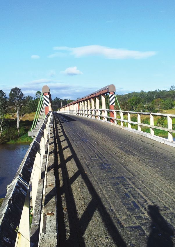
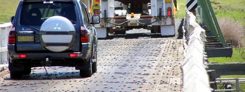
Preferred Route ReportThe nearest hospital and high school are at Bonalbo, approximately 27 kilometres from Tabulam. Tertiary technical studies are available through TAFE campuses at Casino and Tenterfield. 4.2 Existing highway 4.2.1 Road reserve The existing road reserve width along the length of the Bruxner Highway within the study area varies in width. Typically the road reserve width between property boundaries is in the order of 30 metres west of the Clarence River, approximately 60 metres immediately east of Clarence River and approximately 40 metres through the Tabulam village. 4.2.2 Carriageway configuration Existing travel lanes on the Bruxner Highway consist of two 3.5 metre wide sealed lanes with little or no sealed shoulder provided. At the approaches to the existing Tabulam bridge the carriageway tapers to a narrower width of 4.6 metres, this being the width between kerbs on the bridge. Due to the existing bridge being only a single lane configuration, the flow of traffic on the bridge is give way controlled at the western end. 4.2.3 Horizontal and vertical alignment The horizontal alignment west of the Clarence River is a combination of tight bends and lower standard reverse curves. The alignment east of the Clarence River comprises large radius bends and straights. At the western end of the bridge the grade of the existing road drops down to Clarence River Overflow Bridge No 1. The sign posted speed limit through Tabulam village is 50 km/h. 4.2.4 Intersections and private accesses Since the existing Bruxner Highway travels through Tabulam village there are a number of private properties fronting the highway. These properties have direct access to the highway. The major intersections east to west are Lawrence Street, Clarence Street and Tabulam Road east of the bridge, and Clarence River Road west of the bridge. 4.2.5 Structures Bridge over Clarence River at Tabulam The existing bridge over Clarence River at Tabulam is primarily a timber structure and has an overall length of about 300 metres, comprising 13 timber approach spans and five composite timber/steel de Burgh truss central spans. The overall width between kerbs is 4.6 metres, accommodating single lane traffic only. The main spans are supported by concrete piers located in the river, whilst the approaches are supported by timber trestles. The bridge is shown in Figure 4-1 below. The existing bridge deck is above the approximate 1 in 100 year flood level. Tabulam New Bridge 16 Preferred Route Report
You can also read