PARKS GUIDE 2017 2018 - Gold Beach
←
→
Page content transcription
If your browser does not render page correctly, please read the page content below
2017 – 2018
O R E G O N S TAT E

PARKS GUIDE

      CAMPGROUNDS | DAY-USE AREAS | HERITAGE SITES
Celebrating 50 years of
the Oregon Beach Bill.
Forever Yours since 1967.
More on page 17

1969, Seaside

Photo: Oregon Department of Transportation
Portland/Columbia
                                        River Gorge, p. 18                         Central Oregon, p. 36

                                               Astoria

                                                                                                      Pendleton
           North Coast, p. 4                   Tillamook        Portland The Dalles
                                                                                                                 La Grande
                                                            Salem
                                                                                                  Baker City
          Central Coast, p. 9                  Newport
                                                            Eugene          Bend                                                   Eastern Oregon,
    Willamette Valley, p. 26                                                                                                       p. 40

                                           Coos Bay                                                Burns
                                                           Roseburg
          South Coast, p. 14

                                                      Grants Pass
                                                         Medford
    Southern Oregon, p. 32                  Brookings             Klamath Falls

                                                                                                    TABLE OF
                                                                                                    CONTENTS
                                                                                                    How to Use this Guide.............................. 2
                                                                                                    Camping How-To...................................... 3
                                                                                                    North Coast ................................................ 4
                                                                                                    Central Coast ............................................. 8
                                                                                                    South Coast ..............................................14
                                                                                                    Portland/Columbia River Gorge...........19
                                                                                                    Map of Oregon State Parks....................24
                                                                                                    Willamette Valley ....................................27
                                                                                                    Southern Oregon ....................................32
                                                                                                    Central Oregon ........................................36
                                                                                                    Eastern Oregon ........................................40
                                                                                                    Rates, Rules, and Things to Know........46
Crescent Beach viewed from Ecola Point                                                              Types of Campsites .................................47
Please note: This guide provides information about the most developed and/or                        Yurts, Cabins, and Tepees ......................48
frequently visited state parks. This publication is free and may not be sold or                     Group Facilities (Group Camping,
redistributed without written permission from OPRD. It is available in other formats                Meeting Halls, Picnic Shelters) .....................49
upon request. All information is subject to change without notice. Check website or
information line for most current information.
Cover photo: Hug Point State Recreation Site                                                                                                      63400-1570 (1/17)

 oregonstateparks.org               •       reservations: 1-800-452-5687                      •         information: 1-800-551-6949
                                                                        1
HOW TO USE
  THIS GUIDE
                                                                                                         Prospect State Scenic Viewpoint
   Name of Park                LaPine State Park
                                                                                                         All parks have potable water and are open
                                                                                                         year-round for day use unless otherwise noted.
                                                                                                         This symbol      represents
                                                                                                         year-round camping or lodging.
             Location          On State Recreation Rd. off U.S. 97
                               27 mi. SW of Bend
 Phone Number                  541-536-2071                                                              Notes for RVers
       Camping                 75+ full-hookup, 45+ electrical, 5 rustic cabins,                         Each listing notes the maximum length of
      Picnicking               5 deluxe cabins, meeting hall.                                            campsites if RV camping is allowed; both the
Meeting Facilities             Max. site 90,' some pull-through.                                         RV and any towed vehicles must be able to fit
                               Subalpine forest and mountain lakes in high                               into this space. Some parks have pull-through
                               Cascades. 12 mi. of multi-use trails. Home of Fall                        sites—these are also noted in the listings.
               Other           River Falls and Oregon’s largest Ponderosa Pine                           Look for this symbol      to find parks with
             Features                                                                                    RV dump stations. Please use these stations to
                               (162'). Cross-country skiing and snowshoeing.
                               Rafting and tubing on Deschutes River. Seasonal                           empty full holding tanks rather than campsite
                               park store. Fenced off-leash area.                                        connections, which can overflow.

                                         Symbols
                                                                                                         Park Classifications
                                                                                                         SP: State Park
                                                                                                         SRA/SRS: State Recreation Area/Site
    Beach        Bike        Boat        Day-use         Cabin       Deluxe    Deluxe Yurt Disc Golf     SNA/SNS: State Natural Area/Site
    Access       Path        Ramp       Parking Fee                  Cabin                  Course
                                                                                                         SSV/SSC: State Scenic Viewpoint/Corridor
                                                                                                         SHS/SHA: State Heritage Site/Area

   Dump         Fishing   Hiker/Biker     Hiking       Horse Trail     Hot   Interpretive       Marina   Milo McIver State Park
   Station                 Camping         Trail                     Showers Information

   Paddling Pet-Friendly Picnic         Playground Reservable Restroom         Restroom RV and Tent
            Yurt or Cabin Facilities                  Sites                    Non-Flush Camping

    Scenic    Swimming       Tepee        Wildlife     Year-Round     Yurt      Waterfall
    Views                                 Viewing       Camping
             A blue circle indicates that some, but not all, facilities are
             accessible according to Americans with Disabilities Act (ADA)
             standards. It means you can expect an accessible parking space,
             a clear path of travel to the facility, and adherence to established
             ADA guidelines at that facility. For specific information, call the
             State Parks Information Line at 1-800-551-6949 (Oregon Relay
             for the hearing impaired: dial 7-1-1).

   oregonstateparks.org                            •        reservations: 1-800-452-5687                     •      information: 1-800-551-6949
                                                                                            2
CAMPING HOW-TO
11    Choose your campground and dates: Use this guide or
      visit www.oregonstateparks.org to select a park. About
                                                                                                     3   Plan: If this is your first time camping, it’s a good
                                                                                                         idea to assemble your gear and food beforehand and
      half of State Park campgrounds are first-come, first-served,                                       practice pitching your tent. Before you go, check
      meaning they do not take reservations. If the campground                                           www.oregonstateparks.org for driving directions as
      takes reservations (look for this symbol      in the listing),                                     well as weather forecasts and park advisories (click on
      you can reserve your site(s) one day to nine months in                                             Special Notices at the top). For road conditions, consult
      advance. Reservations are highly recommended in the                                                www.tripcheck.com, which is run by the Oregon
      summer! A length of stay is limited to 14 nights, and                                              Department of Transportation.
      campers must leave the park for at least three nights before
      returning.
                                                                                                     4   Check in at the campground: Stop at the registration
                                                                                                         booth when you arrive. If no ranger is available, you’ll
2     Make a reservation (optional): Call Oregon State Parks’
      call center toll-free at 1-800-452-5687, Monday through
                                                                                                         need to complete a self-registration envelope. Just insert
                                                                                                         your reservation confirmation, tear off the top receipt,
      Friday, 8 a.m.-5 p.m. You can also reserve online or take a                                        and deposit the envelope in the payment box. (If you
      chance and show up at a park hoping that a campsite will                                           don’t have a reservation, you can find an open tent or RV
      be available. Just remember that if you arrive at a reservable                                     site by checking a list at the registration booth or looking
      campground without a reservation, you may be able to                                               for tags at the sites. Then fill out the self-registration
      register only for a single night.                                                                  envelope by inserting your payment, tearing off the top
                                                                                                         receipt, and dropping the envelope in the box.) Display
      Please note: If you are planning to rent a yurt,                                                   the receipt on the dashboard of your car; it counts as
      cabin, or tepee without a reservation and arrive after 8 p.m.,                                     your parking permit.
      there may not be anyone available to check you in. It’s best to

                                                                                                     5
      arrive before 5 p.m. or make a reservation in advance.
                                                                                                         Set up your site!

                          YOUR SUPPORT
                                            helps make this possible

                                                                                                                                                      OREGON STATE PAR
                                                                                                                                                     F O U N D AT I O
     Whether you call Oregon home every day or just during that special     To make a tax-deductible donation,
     vacation, you can depend on our state parks to rekindle your spirit.   call us at (503) 802-5750 or visit
     Our state parks depend on you to keep them strong for generations      oregonstateparksfoundation.org                OREGON STATE PARKS
     to come. Please help us today.
                                                                            Join the conversation!                        F O U N D AT I O N

                                                                                            3
Oswald West State Park

         NORTH
         COAST

 View north from Cape Lookout State Park

    O       regonians treasure their beaches.
            The entire 362-mile coastline is
     protected from development, thanks to
     Oregon’s famous 1967 Beach Bill. Come
     to the north coast to watch for whales,
     learn about Oregon’s military defense
     history at Fort Stevens, and hike rugged
                                                                         Coastal recreation
     headlands in Lewis and Clark’s footsteps.                       activities may be restricted
                                                                    during Western Snowy Plover
                                                                       nesting season. Check
                                                                           bit.ly/wsplover

   oregonstateparks.org
oregonstateparks.org           • • reservations:
                                      reservations: 1-800-452-5687 • • information:
                                                 1-800-452-5687           information: 1-800-551-6949
                                                                                    1-800-551-6949
                                                    44
Campgrounds with ❂ Beach Access
Day‑use Facilities Bike Path
Cape Lookout State Park ❂ Boat Ramp
30
Day-Use
Parking Fee
❂
❂ Cabin
On Cape Lookout Rd. off U.S. 101 101
11 mi. SW of Tillamook 202
Deluxe
Cabin
503-842-3182
38 full-hookup, 1 electrical, 170 tent, 13 yurts, Deluxe Yurt
6 deluxe cabins, 2 group tent areas, 1 meeting Disc Golf
hall, 1 group picnic area with shelter. (summit elevation 3,283 feet)
Course
Tillamook
Max. site 60.' Rock Lighthouse Dump
Includes Netarts Spit, Cape Lookout Headland, Station
26
5½-mi. of beach, 7 mi. of hiking trails including Fishing
nature trail and 2½-mi. trail to end of cape for
whale watching. Dump station closed Nov.-April. Hiker/Biker
Neahkahnie Camping
Mountain
(elevation
53 Hiking Trail
Devil’s Lake SRA 1,661 feet)
Horse Trail
Hot
Showers
On NE 6th Dr. off U.S. 101 in Lincoln City Interpretive
541-994-2002 Information
25+ full-hookup, 5 electrical, 50+ tent, Marina
10 yurts. Max. site 55.'
101 Paddling
Close to shopping, entertainment, and beach.
Full and electrical sites have cable TV Cape Meares Lighthouse
6
Pet-Friendly
connections. Boat moorage slips (no launch sites). Yurt or Cabin
East Devil’s Lake day-use area is a 10 minute Picnic
drive from the campground. ODFW-designated Facilities
wildlife viewing area with picnic and Three
101 Playground
boat launch facilities. Capes
Reservable
Sites
Fort Stevens State Park
Scenic
Loop
Restroom
Restroom
Non-Flush
RV and Tent
Camping
101 22
Scenic
On Ridge Rd. off U.S. 101 10 mi. W of Astoria Views
503-861-1671
Swimming
170+ full-hookup, 300+ electrical, 6 tent,
15 yurts, 11 deluxe cabins, 2 picnic shelters. Tepee
18
Max. site 69,' some pull-through.
Historic site at mouth of Columbia River with Wildlife
Viewing
museum and remnants of military fort. Part of
Year-Round
Lewis and Clark National and State Historical Camping
Park. 9 mi. of biking trails, 6 mi. of hiking.
Yurt
Remains of Peter Iredale shipwreck.
Two swimming areas on Coffenbury Lake. Waterfall
5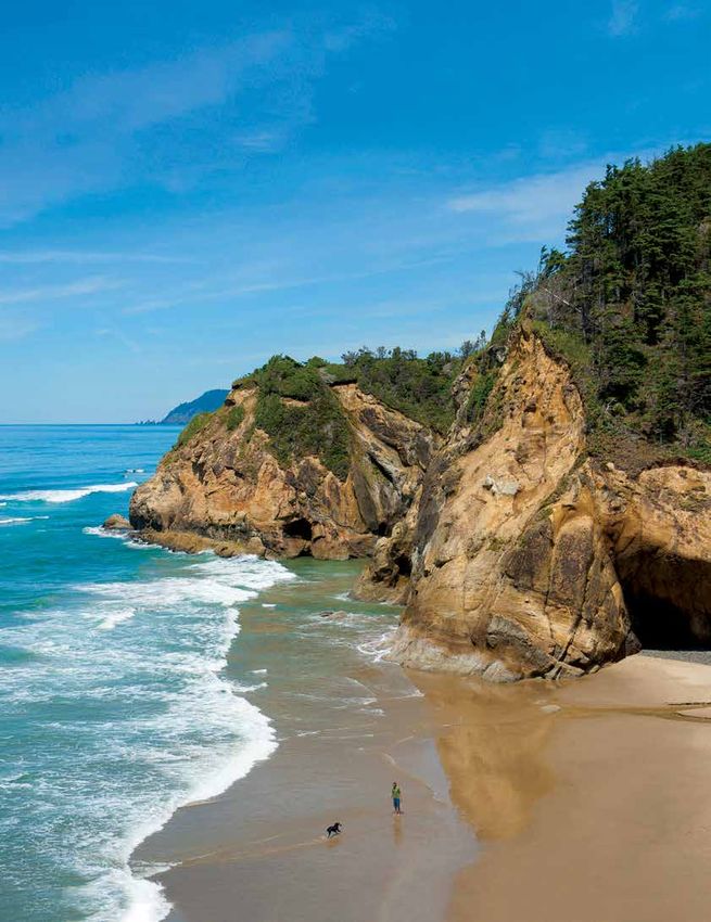
Day‑use Parks

                                                                     Arcadia Beach SRS

                                                                     No drinking water.
                                                                     On U.S. 101 3 mi. S of Cannon Beach
                                                                     More than a mile of beach between two headlands.
                                                                     Tidepooling and surfing.

                                                                     Bob Straub State Park

                                                                     On Sunset Dr. off U.S. 101 1 mi. S of Pacific City
                                                                     Broad beaches on Nestucca Bay sand spit. 4 mi. of hiking
                                                                     and horseback riding trails (equestrian access from county
                                                                     boat ramp parking lot).

                                                                     Bradley SSV

                                                                     On U.S. 30 22 mi. E of Astoria
Hike up the dunes at Cape Kiwanda for views of fragile,              Overlooks Columbia River.
sandstone cliffs that plunge into the cold, churning ocean.
Enjoy the view safely from behind the fence.                         Cape Kiwanda SNA

Nehalem Bay State Park
                                                                     No drinking water or restrooms.
                                                                     On McPhillips Dr. off U.S. 101 1 mi. N of Pacific City
                                                                     Tidepools, dunes and wave-sculpted cliffs that are fenced off
                                                                     for safety on Three Capes Scenic Loop. Whale watching site.
34600 Garey St. off U.S. 101 3 mi. S of Manzanita
503-368-5943                                                         Cape Meares SSV
265 electrical, 6 primitive, horse camp (17 primitive
sites with two-stall corrals, some pull-through), 18 yurts,
meeting hall, group picnic area. Max. site 54.'                      On Cape Meares Lighthouse Dr. off U.S. 101
Spit of land separating ocean and Nehalem Bay at foot of             13 mi. W of Tillamook
Neahkahnie Mtn. (elev. 1,661'). 6-mi. equestrian trail, 2-mi.        Free tours of 1890s lighthouse (open April-Oct.,
hiking/biking path. Primitive sites at fly-in camp adjacent to       11 am-4 pm). 3 mi. of hiking trails. Opportunities to see
airstrip. Crabbing & fishing on bay.                                 colonies of nesting sea birds, whales, seals, and sea lions.
                                                                     Home of the Octopus Tree (an Oregon Heritage Tree and
Saddle Mountain SNA                                                  largest Sitka spruce in the state). Next to Cape Meares
                                                                     National Wildlife Refuge.

On Saddle Mtn. State Park Rd. off U.S. 26                            Clay Myers SNA
14 mi. E of Cannon Beach
503-368-5943
10 walk-in sites and picnic area.                                    No drinking water.
Steep, challenging 2½-mi. trail to summit (elev. 3,283') or          On Sandlake Rd. off U.S. 101 5 mi. N of Pacific City
short Humbug Mtn. Trail. Fields of wildflowers May-July.             Coastal island estuary on Three Capes Scenic Loop with
RVs restricted to parking area. Car camping not allowed.             1½ mi. of hiking trails.

 oregonstateparks.org                  •       reservations: 1-800-452-5687           •      information: 1-800-551-6949
                                                                 6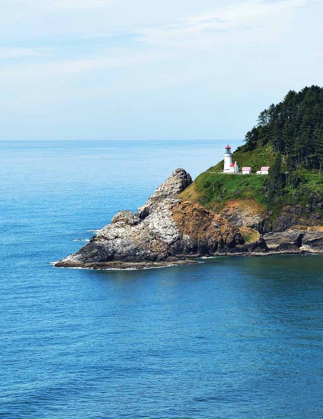
NORTH COAST
D River SRS                                    Manhattan Beach SRS                           Roads End SRS

On SW Hwy. 101 in Lincoln City                 No drinking water.                            On NW Logan Rd. off U.S. 101
At mouth of “world’s shortest                  On U.S. 101 2 mi. N of                        1 mi. N of Lincoln City
river.” Popular for kite flying and            Rockaway Beach                                Sheltered beach. Headland with hidden
beachcombing.                                  Wind-sheltered picnic sites with short        cove accessible at low tide just north of
                                               trail to beach.                               park. Tidepooling, sailboarding, sea
Del Rey Beach SRS                                                                            bird viewing.
                                               Munson Creek
                                               Falls SNS                                     Sunset Beach SRS
No drinking water.
On Highland Ln. off U.S. 101
4½ mi. N of Seaside                            No drinking water or restrooms.               No drinking water.
Short walk to broad, sandy beach.              On Munson Creek Rd. off U.S. 101              On Sunset Beach Ln. off U.S. 101
                                               6 mi. S of Tillamook                          6 mi. N of Seaside
Ecola State Park                               ¼-mi. trail to highest waterfall (319')       Views of Cape Disappointment to
                                               in Coast Range. Salmon spawning               north and Ecola State Park to south.
                                               in fall and winter. No RVs or trailers        West trailhead of 6½-mi. Fort-to-Sea
                                               allowed.                                      Trail. ⅓-mi. boardwalk leading to
On Ecola State Park Rd. off U.S. 101                                                         viewing platform.
2 mi. N of Cannon Beach                        Neskowin Beach SRS
3 hike-in Adirondack-style cabins,                                                           Symons SSV
1 group picnic shelter.
9 mi. of coastline along Tillamook             On U.S. 101 13 miles N of Lincoln
Head. 10+ mi. of trails, including 8-mi.       City in Neskowin                              No drinking water or restrooms.
segment of Oregon Coast Trail and              Wayside with short beach access trail.        On U.S. 131 9 mi. W of Tillamook
2½-mi. Clatsop Loop Trail. Views of            Close to Cascade Head Trail and               Pulloff with ocean views.
offshore lighthouse. Whale watching            canoeing/kayaking on Nestucca Bay.
site. Great tidepooling at Indian Beach.                                                     Tolovana Beach SRS
No overnight parking.                          Oceanside Beach SRS
H.B. Van Duzer                                                                               On W Warren Way off U.S. 101
                                               On Rosenberg Loop off U.S. 101 in
Forest SSC                                     Oceanside 11 mi. W of Tillamook
                                                                                             1 mi. S of Cannon Beach
                                                                                             Views of Haystack Rock.
                                               Views of Three Arch Rocks National
No drinking water.                             Wildlife Refuge. Beachcombing, agate
On OR-18/Salmon River Hwy.                     hunting, tidepooling.
15 mi. NE of Lincoln City
On Pheasant Creek and Salmon River.            Oswald West
1 mi. E of park entrance is a pulloff with     State Park
a short trail leading to a swimming hole.

Hug Point SRS                                  On U.S. 101 9 mi. S of
                                               Cannon Beach
                                               16 mi. of hiking trails through old-
No drinking water.                             growth forest to tip of Cape Falcon
On U.S. 101 5 mi. S of Cannon Beach            and secluded beaches, including
Historic wheel tracks carved into              13 mi. of Oregon Coast Trail.
rock where stagecoaches “hugged”               Popular for surfing. Limited shoreline
the headland. Natural caves.                   fishing and intertidal harvest allowed;
                                               see dfw.state.or.us for rules.
                                                                                             Cannon Beach

 oregonstateparks.org               •        reservations: 1-800-452-5687                •      information: 1-800-551-6949
                                                                  7
Heceta Head Lighthouse

       CENTRAL
        COAST

     Jessie M. Honeyman Memorial State Park

      V      isitors flock to the central coast for
             its picturesque lighthouses, long
      sandy beaches and teeming tidepools. Kayak
      up Beaver Creek at Brian Booth State Park
      for exceptional birding, or see a rare
      carnivorous lily at Darlingtonia on your
      way south to acres of wind-sculpted dunes.

                                                                             Coastal recreation
                                                                         activities may be restricted
                                                                        during Western Snowy Plover
                                                                           nesting season. Check
                                                                               bit.ly/wsplover

   oregonstateparks.org            •      reservations: 1-800-452-5687   •    information: 1-800-551-6949
oregonstateparks.org           •       reservations: 1-800-452-5687    •   information: 1-800-551-6949
                                                       88
Lincoln City
Campgrounds Gleneden Beach
State Recreation Site 101
Beach Access
with Day‑use Fogarty Creek
State Recreation Area Fishing Rock
Bike Path
Facilities Boiler Bay
State Scenic Viewpoint
State Park
Whale Watching Center Boat Ramp
Rocky Creek Depoe Bay
Beachside SRS State Scenic Viewpoint
Cape Foulweather 229
Day-Use
Parking Fee
Otter Crest
State Scenic Viewpoint
Beverly Cabin
Devil’s Punchbowl Beach
State Natural Area State Park Deluxe
Cabin
On U.S. 101 4 mi. S of Waldport 20
Newport Ellmaker
541-563-3220 Agate Beach State Wayside Deluxe Yurt
State Recreation Site Toledo
2 full-hookup, 30+ electrical, 40+ Yaquina Bay Disc Golf
tent, 2 yurts. Max. site 40.' State Recreation Site To Corvallis Course
Campsites are just a short walk to South Beach
Lost Creek Dump
State Park
broad, sandy beach. Close to tidepools State Recreation Site Station
at Seal Rock. Brian Booth Fishing
Seal Rock State Park
State Recreation Site
Alsea
Beverly Beach Driftwood Beach
State Recreation Site
Bay Alsea Bay Bridge Historic
Interpretive Center
Hiker/Biker
Camping
State Park Gov. Patterson Memorial
State Recreation Site
Waldport
Hiking Trail
34
Beachside To Corvallis
Horse Trail
State Recreation Site W.B. Nelson
State Recreation Site
Yachats Smelt Sands Hot
State Recreation Area
On U.S. 101 7 mi. N of Newport State Recreation Site Showers
541-265-9278 Yachats Interpretive
Cape Perpetua Information
50+ full-hookup, 75 electrical, 125+ Neptune
tent, 21 yurts, 3 group tent areas, Stonefield Beach
State Recreation Site
State Scenic
Viewpoint Marina
yurt meeting hall. Max. site 65,' Tokatee Klootchman
some pull-through. State Natural Site Paddling
Sandy beach between Yaquina Head Muriel O. Ponsler Mem. Carl G.
State Scenic Viewpoint Washburne Pet-Friendly
and Otter Rock. Interpretive center and Heceta Head Memorial Yurt or Cabin
State Park
1-mi. nature trail. Close to lighthouses, Heceta Head Picnic
Oregon Coast Aquarium, and wildlife Lighthouse Facilities
State Scenic Viewpoint
viewing areas. 36 Playground
Darlingtonia Mapleton
Reservable
Carl G. Washburne State Natural Site
126
Sites
Memorial State Park Florence To Eugene
Restroom
on Area
Woahink Lake Restroom
Jessie M. Non-Flush
Honeyman
Recreati
RV and Tent
On U.S. 101 14 mi. N of Florence Memorial Camping
State Park
541-547-3416 101 Scenic
ational
50 full-hookup, 7 electrical, 7 walk-in Views
N
tent, 2 yurts. Max. site 57.' Swimming
Dunes
Campsites are first-come, first served—
yurts are reservable.Whale watching, Tepee
Oregon
tidepooling, beachcombing. 6-mi. round- Bolon Island Tideways
State Scenic Corridor
Wildlife
trip trail to Heceta Head Lighthouse. Winchester Bay Umpqua To Eugene/
Viewing
5 mi. of beach. Reedsport 38 State Scenic Corridor Roseburg Year-Round
Umpqua Camping
Lighthouse
State Park Yurt
Waterfall
To Coos Bay
9TIDEPOOLS ARE ALIVE Jessie M. Honeyman
Memorial State Park
On U.S. 101 3 mi. S of Florence
541-997-3641
45+ full-hookup, 120+ electrical,
185+ tent, 10 yurts, 6 group tent
areas, meeting hall, group picnic
area and shelter. Max. site 60.'
Campground adjacent to Oregon
Dunes National Recreation Area.
Five mi. of hiking trails. Three
freshwater lakes with year-round
fishing and seasonal boating and
swimming. Access to dunes from
campsites and day-use area (seasonal
off-road vehicle access).
O regon’s 362-mile coastline is home to a rich mix of extraordinary
animals, revealed only when the tide retreats. Colorful rocky
shore species like anemones, crabs, sea stars, and barnacles have
South Beach
State Park
adapted to the volatile environment where land meets sea. Start
your exploration at one of 27 state parks, some of which offer roving
interpreters and seasonal tidepool programs. These are our top picks,
listed north to south:
On U.S. 101 4 mi. S of Newport
Seasonal interpreters at Haystack Rock’s easy-to-access tidepools 541-867-4715
in Cannon Beach offer an educational display, microscopes and 225+ electrical, 60 tent, 27 yurts,
touch tanks. More challenging trails lead to tidepools at Ecola (near 3 group tent areas, meeting hall.
Cannon Beach) and Oswald West (near Manzanita). Max. site 56.'
Campground with visitor center
At Seal Rock SRA south of Newport, a more challenging trail leads and interpretive center. 1¾-mi.
to a dazzling display, and an interpretive ranger offers seasonal tours. nature trail and 2¾-mi. paved bike
path from day-use area to South
Carl B. Washburne State Park south of Yachats is a great base for Jetty with views of Yaquina Bay
intertidal exploration at nearby Neptune SSV and Heceta Head and lighthouses. South Jetty has a
Lighthouse SSV. The rocky pools at Neptune’s Strawberry Hill are a horse offloading area with short
local favorite that could take all day to explore. trail to beach for riding along shore
(no horses allowed inside park).
Harris Beach north of Brookings also has seasonal interpreters at Accessible interpretive boardwalk.
its tidepools and intertidal programs at the campground. Seasonal kayak tours (July 4-Labor
Day), guided hikes, and Junior
Check oregontidepools.org and bit.ly/OPRDcalendar for a list Ranger activities. Crabbing,
of tidepool programs at these and other parks. Whether you decide windsurfing, and beachcombing.
to explore on your own or join a guided program, it’s important
to treat these fragile ecosystems gently. More information and
tidepool etiquette are in our Tidepools are Alive brochure,
bit.ly/oregontidepools.
10CENTRAL COAST
Umpqua Lighthouse
State Park
On Lighthouse Rd. off U.S. 101
3 mi. S of Reedsport
541-271-4118
10 full-hookup, 9 electrical, 20+
tent, 8 yurts (6 deluxe), 2 cabins.
Max. site 56.'
Near historic lighthouse and
Oregon Dunes National
Recreation Area. 1-mi. hiking
trail. Whale watching site.
Day‑use Parks
Devil’s Punchbowl State Natural Area
Agate Beach SRS
Bolon Island Devil’s Punchbowl SNA
On U.S. 101 1 mi. N of Newport Tideways SSC
Connects to 1-mi. Big Creek On First St. off U.S. 101 8 mi. N of
Trail. Views of Yaquina Head No drinking water or restrooms. Newport
Lighthouse. Razor clamming and On U.S. 101 ½ mi. N of Reedsport Hollow rock formation with churning
surfing. Large parking area with Island in Umpqua River. ½-mi. hiking surf. Tidepooling among marine gardens.
room for trailers. trail with opportunities to Whale watching site.
see nesting cormorants.
Alsea Bay Historic Driftwood Beach SRS
Interpretive Center Brian Booth State Park
On U.S. 101 3 mi. N of Waldport
On NW Maple St. off U.S. 101 Wide, sandy beach and picnic sites
in Waldport among shore pines.
Bridge tours and guided clamming On U.S. 101 and N. Beaver Creek Rd.
and crabbing. Access to tidal 8 mi. S of Newport Ellmaker State
estuary. Historic displays 541-563-6413
Home of Ona Beach and Beaver Wayside
and videos.
Creek. Marsh, upland meadows, and
Boiler Bay SSV beachfront with 5 mi. of hiking trails.
Nature Center open all year. Guided On U.S. 20 23 mi. W of Corvallis
kayak tours July 4 through Labor Day. Picnic spot between Newport and
Corvallis.
On U.S. 101 1 mi. N of
Depoe Bay Darlingtonia SNS Fishing Rock State Park
Panoramic views of surf,
whales, and sea birds.
On U.S. 101 5 mi. N of Florence No drinking water or restrooms.
Only state park dedicated to protecting On Fishing Rock Dr. off U.S. 101
a plant species—the carnivorous 2-3' 1 mi. S of Lincoln Beach
tall cobra lily. ½-mi. boardwalk trail. Hidden spot with ½-mi. trail to
panoramic ocean viewpoint.
oregonstateparks.org • reservations: 1-800-452-5687 • information: 1-800-551-6949
11CENTRAL COAST
Fogarty Creek SRA Heceta Head Neptune SSV
Lighthouse SSV
On U.S. 101 2 mi. N of Depoe Bay No drinking water.
Picnic area with shelter. Birding, On U.S. 101 13 mi. N of Florence On U.S. 101 3 mi. S of Yachats
tidepooling. Short trail to assistant lightkeeper’s Four pull-offs south of Cape Perpetua.
house (now a B&B) and historic Tidepooling, whale watching, agate
Gleneden Beach SRS lighthouse (open for tours depending hunting, seal and sea lion viewing.
upon weather and staffing—call
541-547-3416 to check hours). Otter Crest SSV
On U.S. 101 7 mi. S of Lincoln City Tidepools and caves. Seabird nesting
Surfing, seal and sea lion viewing. area. Whale watching.
Picnic shelter. No drinking water or restrooms.
Lost Creek SRS On Otter Crest Loop off U.S. 101
Governor Patterson 10 mi. N of Newport.
Memorial SRS Whale watching site on Cape
No drinking water. Foulweather. Views of Devil’s Punchbowl.
On U.S. 101 7 mi. S of Newport Small gift shop and interpretive center.
On U.S. 101 1 mi. S of Waldport Beachcombing and whale watching.
Beach near mouth of Alsea Bay. Storm Rocky Creek SSV
and whale watching, windsurfing, Muriel O. Ponsler
crabbing, seal viewing. Memorial SSV On U.S. 101 2 mi. S of Depoe Bay
Forested bluff overlooking ocean. Whale
No drinking water or restrooms. watching site.
On U.S. 101 16 mi. N of Florence
Five miles of sandy beach. Whale Seal Rock SRS
watching and beachcombing.
On U.S. 101 10 mi. S of Newport
Wayside with offshore rock formations
and tidepools.
Smelt Sands SRS
On Lemwick Ln. off U.S. 101
in Yachats
Trailhead for historic 804 Trail (¾-mi.
north segment and 1-mi. south segment).
Tidepooling and whale watching.
Annual smelt run.
Stonefield Beach SRS
No drinking water or restrooms.
On U.S. 101 6 mi. S of Yachats
Broad, sandy beach.
Seal Rock State Recreation Site
oregonstateparks.org • reservations: 1-800-452-5687 • information: 1-800-551-6949
12SHINE A LIGHT ON HISTORY
Tokatee Klootchman SNS
No drinking water or restrooms. Tillamook Rock
On U.S. 101 17 mi. N of Florence Lighthouse
Ocean viewpoint and whale watching site.
Cape Meares
Lighthouse
Umpqua SSC
No drinking water.
On OR-38 9 mi. E of Reedsport
Small park with boat ramp on Yaquina Head
Lighthouse
Umpqua River. Yaquina Bay
Lighthouse
W.B. Nelson SRS Heceta Head
Lighthouse
Umpqua River
No drinking water. Lighthouse
On OR-34/East Alsea Hwy. Cape Meares Lighthouse Cape Arago Lighthouse
1 mi. E of Waldport
O
Coquille River Lighthouse
Freshwater lake and scenic wetland area. regon lighthouses all have stories
Small fishing dock extends into to tell: their construction, the Cape Blanco
Eckman Lake. Lighthouse
brutal storms they endured, the ghosts
that are said to haunt them, and the
Whale Watching Center
lighthouse keepers who kept lonely vigil
from their towers.
On U.S. 101 in Depoe Bay
541-765-3304 Nine original lighthouses stretch from
Home of Whale Watching Spoken Tillamook in the north to Cape Blanco in the south. Five are open to the
Here program. Interpretive exhibits. public seasonally; some offer tours that include a climb to the lantern or
Staffed by State Parks rangers. tower watch rooms. Many are listed on the National Register of Historic
Places. They are a perfect destination for a coastal day trip or weekend
Yachats SRA getaway. All are located near state campgrounds and coastal attractions
including tidepools and trails.
On Ocean View Dr. via West 2nd St. On the Three Capes Scenic Loop, Cape Meares Lighthouse and the
off U.S. 101 in Yachats
Scenic 1-mi. loop overlooking Yachats
cape where it perches offer excellent views of wildlife, including peregrine
Bay and ocean. Tidepooling and whale falcons that nest on the cliffs in spring and whales that migrate in winter.
watching. Accessible observation deck. Yaquina Head, still active, is the tallest lighthouse at 93 feet and still has
its original lens. Heceta Head’s powerful beam shines the furthest— 21
Yaquina Bay SRS miles out to sea. The tower reopened in 2013 after a two-year restoration
project. This is a premium spot to watch whales and birds.
On U.S. 101 in Newport Umpqua River Lighthouse is also a fantastic place to see whales.
Historic lighthouse open for tours Furthest south is Cape Blanco, which towers majestically above the
(call 541-265-5679 for hours or to
schedule group tour). Gift shop. Near
westernmost point in Oregon and features the oldest continuously
Hatfield Marine Science Center and operating light.
Oregon Coast Aquarium. For information on Oregon’s lighthouses, call 800-551-6949 or pick
up an Oregon Coast Lighthouse Brochure. View the brochure online at
http://bit.ly/oregonlighthouses.
13SOUTH
COAST
Humbug Mountain State Park
T his is the wild end of the Oregon
Coast—rugged, less traveled and
stunningly scenic. The warmer climate and
sunnier days lure hikers and campers with
fragrant spring wildflowers, spectacular
sunsets and beautiful blooms within the
manicured gardens at Shore Acres.
Coastal recreation
activities may be restricted
during Western Snowy Plover
nesting season. Check
bit.ly/wsplover
oregonstateparks.org • reservations: 1-800-452-5687 • information: 1-800-551-6949
14Campgrounds with Beach Access
Day‑use Facilities Reedsport
Bike Path
Alfred A. Loeb State Park William M. Tugman
State Park N.Tenmile Lake
Boat Ramp
Tenmile Lake
Golden and Day-Use
101 Parking Fee
On N Bank Chetco River Rd. off Silver Falls
State Natural
U.S. 101 8 mi. E of Brookings Area Cabin
541-469-2021
45+ electrical, 3 reservable cabins. Max. Sunset Bay North Deluxe
State Park Bend Cabin
site 56.' Shady campground on Chetco River, Cape Arago Lighthouse Co
os
nestled in a protected grove of myrtlewood. Shore Acres Coos Riv
er Deluxe Yurt
Bay
State Park
Self-guided ¾-mi. nature trail starts at Loeb, Cape Arago Disc Golf
connects to Forest Service trail (1-mi. loop), State Park Course
which features northernmost redwood grove Seven Devils
Dump
Station
in the U.S. State Recreation Site
rk
Coquille Fishing
Nor th Fo
Bullards Beach Bullards Beach
State Park
State Park Coquille River Lighthouse Hiker/Biker
Coqu
Coquille
R iver Camping
42s
ille
Face Rock
Hiking Trail
River
State Scenic Viewpoint Bandon
Bandon Myrtle Point
State Natural Area
Hoffman 42 Horse Trail
Remote
Oregon Memorial Midd
le Fo
Coast Trail State Wayside rk Hot
Showers
On U.S. 101 2 mi. N of Bandon Coquille To Roseburg Interpretive
541-347-2209 101
Floras Lake Myrtle Grove Information
State Natural Site
100+ full-hookup, 80+ electrical, 8 horse, Powers Marina
Sou
Cape Blanco Lighthouse
13 yurts (3 pet friendly), new hiker-biker
th F
Cape Blanco Sixes
sites, meeting hall, 2 picnic shelters.
ork
State Park Sixes River Paddling
Max. site 64.' Paradise Point
n Range
State Recreation Site
Large, family-oriented park at mouth of Tseriadun Port Orford Pet-Friendly
State Recreation Site Yurt or Cabin
Coquille River. Tours of historic lighthouse Elk River
Coast Mountai
Port Orford Heads Picnic
mid-May through Sept. Twelve mi. of hiking State Park State Scenic Waterway Facilities
r
and equestrian trails to dunes. Across from Humbug Mountain ue
Rive
State Park Rog Playground
Bandon Marsh National Wildlife Refuge (summit elevation 1,756 feet)
r w ay
and Bandon-by-the-Sea with shops and Arizona Beach te
Reservable
a
State Recreation Site
Scenic W
Sites
restaurants. Crabbing from docks and on river.
Kla unta
Mo
Sisters Rock
ma ins
ay Restroom
Ophir
th
w
Cape Blanco State Park
er
State Recreation Site
tate
at
Illin
W
Geisel Monument State Scenic Restroom
ois
S
State Heritage Site Non-Flush
Riv
Rogue River
Otter Point
er
State Recreation Site RV and Tent
Camping
Oregon Gold Beach
Coast Trail
On Cape Blanco Rd. off U.S. 101 Scenic
Views
9 mi. N of Port Orford
541-332-2973 Cape Sebastian Swimming
State Scenic Corridor
50+ electrical, 8 horse (4 single corrals and 2
Tepee
double corrals), 4 cabins, 1 group RV camp Pistol River
State Scenic Viewpoint
(accommodates up to 50 ppl and 24 vehicles,
r
Wildlife
Rive
101 Viewing
including 5 RVs). Max. site length 65.'
tco
Che
8+ mi. of hiking trails and 7 mi. of horse trails. Year-Round
Samuel H. Boardman Camping
150 acres of open riding range. Black sand State Scenic Corridor Alfred A. Loeb
State Park
beach. Fishing on Sixes River. Tours of historic Cape Ferrelo Yurt
Harris Beach Brookings
Hughes House and Cape Blanco Lighthouse State Recreation Area Winchuck
McVay Rock State Recreation Site Waterfall
Apr.-Oct. 10 am-3:30 pm. (closed Tuesdays). State Recreation Site Crissey Field
To Crescent City State Recreation Site
oregonstateparks.org • reservations: 1-800-452-5687 • information:
C A L I F O R1-800-551-6949
NIA
15SOUTH COAST
Harris Beach SRA Sunset Bay State Park
Day‑use Parks
Arizona Beach SRS
On U.S. 101 1 mi. N of Brookings On Cape Arago Hwy. off U.S. 101 12
541-469-2021 mi. SW of Coos Bay On U.S. 101 11 mi. S of Port Orford
35+ full-hookup, 54 electrical, 541-888-4902 Stretch of sand between two headlands.
56 tent, 6 yurts. Max. site 50.' 25 full-hookup, 30+ electrical, 65+ Wildlife viewing (elk and waterfowl) on
2 mi. of hiking trails, ½-mi. biking/ tent, 8 yurts, 1 group tent area, creek wetlands. Fishing on Arizona Pond
pedestrian path. Views of Oregon’s largest meeting hall, group picnic area. Max. open to youth only.
offshore island, Bird Island, a wildlife site 51.'
sanctuary and breeding ground for puffins. Bay-sheltered beach. 10 mi. of hiking Bandon SNA
Tidepooling and beachcombing. trails connect to Shore Acres SP and Cape
Arago SP with views of Gregory Point
Humbug Mountain and Cape Arago lighthouse. Golf course On Beach Loop Rd. off U.S. 101
State Park nearby. 5 mi. S of Bandon
Three beach waysides with ¼-mi. hiking
William M. Tugman trail. No camping within
State Park city limits.
On U.S. 101 6 mi. S of Port Orford Cape Arago State Park
541-332-6774
35 electrical, 55+ tent, 1 group tent
area. Max. site 96,' some pull-through. No drinking water.
Campground surrounded by forested hills. On U.S. 101 8 mi. S of Reedsport On Cape Arago Hwy. off U.S. 101 14
5½-mi. loop trail to summit of Humbug mi. SW of Coos Bay
541-759-3604
Mtn. (elev. 1,756'). Windsurfing. Group tent area (by reservation only),
90+ electrical, 16 yurts, picnic shelter.
picnic shelter. Opportunity to view sea
Max. site 50.'
birds and offshore colonies of seals and
Freshwater lake with 4 mi. hiking/
sea lions at Shell Island (part of Oregon
biking trail. Close to Oregon Dunes
Islands National Wildlife Refuge). ½-mi.
National Recreation Area. Picnic gazebo
trail to refuge and tidepools closed
surrounded by green lawn.
March 1- June 30 to protect wildlife.
Harris Beach State Recreation Area
Cape Sebastian SSC
No drinking water or restrooms.
On U.S. 101 7 mi. S of Gold Beach
1½-mi. trail to tip of cape with panoramic
views. Whale watching.
Coquille Myrtle Grove
SNS
No drinking water.
On Powers Hwy./OR-542 off OR-42
14 mi. S of Myrtle Point
Swimming hole on Coquille River with
hand-launch boating.
oregonstateparks.org • reservations: 1-800-452-5687 • information: 1-800-551-6949
16CELEBRATING 50 YEARS OF
Crissey Field SRS THE OREGON BEACH BILL
On U.S. 101 5 mi. S of Brookings
40-acre park with welcome center between
California border and Winchuck River. Hours
vary—call 541-469-4117 or 541-469-2021.
Face Rock SSV
On Beach Loop Dr. off U.S. 101
1 mi. SW of Bandon
Cliff viewpoint overlooking ocean and Face Rock
with short trails to beach and rocky intertidal
areas. Whale watching site.
Geisel Monument SHS
No drinking water or restrooms.
On U.S. 101 7 mi. N of Gold Beach Cape Lookout State Park
Peaceful rest stop with gravesites of early settlers.
Golden and Silver Falls
SNA B eachcombers have long strolled along Oregon’s beaches
secure in the knowledge that the iconic stretches are
preserved for all to enjoy. But it easily could have been a different
No drinking water.
story. As 1967 dawned, the risk that more of the state’s beloved
On Glen Creek Rd. beaches might fall into private hands loomed large. The threat was
24 mi. NE of Coos Bay driven home the previous summer, when a Cannon Beach motel
2 mi. of hiking trails, including 1½-mi. trail owner fenced off an area of beach around his motel and planted
through old-growth forest to top of 100'
Golden Falls.
signs warning: “Guests Only Please.”
Luckily, beachgoers took notice and quickly communicated their
Hoffman Memorial
unhappiness in letters to state authorities. In the spring of 1967,
State Wayside
Rep. Sidney Bazett, Rep. W. Stan Ouderkirk and Sen. Anthony
Yturri introduced HB 1601, soon to be dubbed the Beach Bill. At
No drinking water. first, few paid much attention. That is until reporter Matt Kramer
On Coos Bay-Roseburg Hwy./OR-42
3 mi. S of Myrtle Point wrote a series of news stories alerting the public to what they
Shaded myrtlewood grove. stood to lose.
McVay Rock SRS After months of battle that nearly killed it, the Beach Bill passed
the House and Senate. Gov. Tom McCall signed it into law on
No drinking water or restrooms. July 6, 1967. And so it is that today Oregonians and visitors from
On Oceanview Dr. off U.S. 101 all over the world can enjoy our beaches and all the wonders they
2 mi. S of Brookings offer. Take a stroll, explore our tidepools, hunt for agates and
Hidden park used for surf fishing, fossils, dip your toes in the sand—and know this beach is yours
clamming, whale watching, and
beachcombing. 9-hole disc golf course. and mine and everyone’s. Now that’s something to celebrate.
Fenced off-leash area.
17Seven Devils SRS
No drinking water.
On Seven Devils Rd. off U.S. 101
10 mi. N of Bandon
Out-of-the-way beach popular for
agate hunting.
Shore Acres
State Park
No drinking water.
On Cape Arago Hwy.
13 mi SW of Coos Bay
Former estate of timber/shipping magnate
with seven acres of formal gardens. Gift
shop and ocean observation building.
Whale watching site. Hosts Holiday Lights
display each winter. Open 8 am-dusk.
No dogs.
Beach at Samuel H. Boardman State Scenic Corridor
Sisters Rock SRS
Ophir SRS Pistol River SSV
No drinking water or restrooms.
On U.S. 101 14 mi. S of Port Orford
On U.S. 101 10 mi. N of Gold Beach No drinking water or restrooms. Secluded beach access with rock features.
Picnic area with wide sandy beach and On U.S. 101 11 mi. S of Short trail down to sea cave. Tidepooling.
views of sea stacks. Gold Beach
Dunes and ponds with waterfowl and Tseriadun SRS
Otter Point SRS shorebirds. Popular windsurfing spot.
Port Orford Heads No drinking water or restrooms.
No drinking water or restrooms.
On Old Coast Rd, off U.S. 101 4 mi. State Park W on 12th St. in Port Orford.
Follow to end.
N of Gold Beach On south side of Garrison Lake. Wave
Trails overlook pristine beaches and W on 9th St. in Port Orford. Follow watching and beachcombing.
sandstone formations. signs to Port Oford Heads parking lot.
Trails along oceanside bluffs with views of Winchuck SRS
Paradise Point SRS offshore rocks and coves. Historic Coast
Guard Lifeboat Station (now a museum).
Open April-Oct. 10 am-3:30 pm No drinking water or restrooms.
No drinking water or restrooms. On U.S. 101 5 mi. S of Brookings
W on Paradise Point Rd 2 mi. NW of (closed Tuesdays).
Seven-acre park with access to Winchuck
Port Orford. Follow road to end.
Wayside with coastal vista from Samuel H. Boardman River and ocean.
Port Orford Heads to Cape Blanco. SSC
Beachcombing, agate hunting,
and sunset viewing. No drinking water.
On U.S. 101 N of Brookings
12-mi. stretch of forested waysides
connecting coastal cliffs and beaches. 18
mi. of Oregon Coast Trail. 300-yr.-old
Sitka spruce trees.
oregonstateparks.org • reservations: 1-800-452-5687 • information: 1-800-551-6949
18Crown Point State Scenic Corridor
PORTLAND/
COLUMBIA
RIVER GORGE
Banks-Vernonia State Trail
E xtending from the dry grasslands of
the eastern Columbia Gorge to the
forested foothills of the Cascade Range, the
region surrounding Portland encompasses a
little of everything. Parks here feature awe-
inspiring waterfalls, world-class steelhead
fishing, competition-level disc golf courses
and miles of bike paths and wooded trails
for hiking and horseback riding.
oregonstateparks.org
oregonstateparks.org •• reservations:1-800-452-5687
reservations: 1-800-452-5687 •• information:1-800-551-6949
information: 1-800-551-6949
19
19Beach Access
Bike Path
Boat Ramp
Day-Use
Parking Fee
Cabin
Deluxe
Cabin
Deluxe Yurt
Disc Golf
Course
Dump
Station
Fishing
Hiker/Biker
Camping
Hiking Trail
Horse Trail
Hot
Showers
Interpretive
Information
Marina
Paddling
Pet-Friendly
Yurt or Cabin
Picnic Deschutes River SRA
Facilities Campgrounds with
Playground
Day‑use Facilities
Reservable
Sites
Ainsworth State Park On OR-206/Biggs-Rufus Hwy. off I-84
Restroom 15 mi. E of The Dalles
Restroom
541-739-2322
Non-Flush On E Historic Columbia River Hwy. 30+ electrical, 25 primitive, 4 group RV camps. Max.
RV and Tent 18 mi. E of Troutdale (exit #35 off I-84) site 50.'
Camping 503-695-2261 At confluence of Deschutes and Columbia Rivers. 22-mi.
Scenic 40+ full-hookup, 6 walk-in tent. Max. site 60,' round-trip horse trail (open March-June by reservation
Views some pull-through. only). 17-mi. one-way bike trail. 8 mi. of hiking trails,
Swimming Campground in forest setting. Connections to many including 4-mi. Atiyeh Deschutes River Trail. Oregon Trail
Gorge trails, including U.S. Forest Service Trail exhibit. Canyon rafting, tubing, and waterskiing. Jetboat
Tepee #400. Day-use area and picnicking located ¼ mi. launch at Heritage Landing day-use area, across river.
W of campground. Open seasonally (mid-March to Water shut off in winter.
Wildlife
Viewing end of Oct.). Reservable as of January 15, 2015.
Year-Round
Camping
Yurt
Waterfall
oregonstateparks.org • reservations: 1-800-452-5687 • information: 1-800-551-6949
20Government Island SRA
No drinking water.
In Columbia River near I-205 bridge
503-281-0944
Series of river islands accessible only by boat. Primitive
camping along 17 mi. of shoreline. No designated sites:
camp below vegetation line. Interior of island is protected
(permit required). Two boat docks, floating tie-up, and
picnic shelter.
L.L. “Stub” Stewart State Park
View of Mt. Hood from Milo McIver State Park
On OR-47/Nehalem Hwy. 31 mi. W of Portland
503-324-0606
75 full-hookup, 10+ walk-in tent sites, 20+ hike-to
tent sites. Horse camp (13 single and 2 double full- Viento State Park
hookup sites with 4 and 6-stall corrals). Cabins: 13
single and 3 double; 2 meeting halls, picnic shelter.
Max. site 50,' (3 pull-through).
1,800 acres of hills, forest, and streams. 30+ mi. of On I-84 6 mi. W of Hood River (exit #56)
equestrian, mountain biking (including a free ride course) 541-374-8811
and hiking trails, including portion of the Banks-Vernonia 55+ electrical, 15+ tent. Max. site 35.'
State Trail. Fenced off-leash area. 18-hole and 3-hole disc Seasonal campground with access to Columbia River and Viento
golf courses. Interpretive center and store. Lake for water sports (popular for windsurfing). Paved, accessible
1-mi. section of Historic Columbia River Hwy. State Trail connects
Memaloose State Park to Starvation Creek waterfall. Located next to active rail line—
trains can be heard at all hours. Reservable as of Jan. 15, 2015.
On I-84 11 mi. W of The Dalles (westbound access
only—from I-84 E, take exit #76, return 3 mi. west,
and drive through rest area)
Day‑use Parks
541-478-3008
40 full-hookup, 65+ tent. Max. site 60.'
Railroad prevents safe/legal river access from campground; Bald Peak SSV
access points nearby. Interpretive programs on weekends
Memorial Day-Labor Day. No drinking water.
On SW Bald Peak Rd. off OR-219/NE Hillsboro Hwy.
Milo McIver State Park 9 mi. N of Newberg
Hillside with views of Willamette Valley and Cascades.
Banks-Vernonia State Trail
On Springwater Rd. off OR-211 4 mi. W of Estacada
503-630-7150
40+ electrical, 9 tent, 3 group tent areas, group picnic Off U.S. 26 and OR-47 between the towns of Banks and
areas and 6 picnic shelters. Max. site 86.' Vernonia
Woods and meadows on Clackamas River. 13 mi. of hiking, Forested 21-mi. hiking, biking, and equestrian trail with views
biking, and equestrian trails. Unfenced off-leash area. Fish of Coast Range. Picnic shelter and historic train trestle at Buxton
hatchery. Access to Estacada Lake. Premier 27-hole disc trailhead. Drinking water at L.L. “Stub” Stewart State Park and
golf course. Banks trailhead.
oregonstateparks.org • reservations: 1-800-452-5687 • information: 1-800-551-6949
21Dabney SRA
On E Historic Columbia River Hwy.
4 mi. SE of Troutdale
Popular swimming, rafting, tubing, and picnicking spot with
reservable picnic shelter. 1 mi. of nature trails. No pets permitted.
No alcohol allowed below Stark St. Bridge.
Guy W. Talbot State Park
On Latourell Rd. off Columbia River Hwy. 12 mi. E of
Troutdale
Secluded picnicking site. Main trailhead for 225' Lower Latourell
Historic Columbia River Highway State Trail Falls (short trail underneath bridge) with extension to 134' Upper
Latourell Falls (2-mi. loop). Lower trailhead with reservable picnic
Benson SRA shelter and restrooms ¼ mi. off Historic Hwy. on Latourell St.
Historic Columbia River Highway
Drinking water and restrooms not available in winter. State Trail
On I-84 30 mi. E of Portland (eastbound access only Sections of paved hiking/biking trail along cliffs of Columbia Gorge
from exit #30) (13 mi. total)—motorized use allowed with accessibility devices
Lake offers swimming, trout fishing, and non-motorized only. Seven trailheads off U.S. 30 (listed below, west to east). Note:
boating (boats must be carried a short distance). Paved grooved bike staircase at exit #41/Eagle Creek accommodates
path from parking lot to accessible fishing dock. Reservable single bikes, but is not designed for bike trailers/extensions or
picnic shelter. wheelchairs.
Bonnie Lure SRA John B. Yeon SSC (exit #35 eastbound-Ainsworth
or exit #37 westbound-Dodson)
No drinking water.
No drinking water or restrooms.
On Dowty Rd. off OR-224 6 mi. N of Estacada Tooth Rock (exit #40-Bonneville Dam)
Bank fishing spot along Eagle Creek. ½-mi. hiking trail. No drinking water.
Bridal Veil Falls SSV Cascade Locks/Bridge of the Gods (exit #44)
Seasonal restrooms nearby.
No drinking water. Starvation Creek State Park (exit #55)
On E Historic Columbia River Hwy.
15 mi. SE of Troutdale (exit #28 off I-84)
Paved, accessible ½-mi. loop interpretive trail to Gorge Viento State Park (exit #56)
overlook. Lower 2⁄3-mi. round-trip trail to beautiful Restrooms nearby.
120' waterfall.
Mosier Twin Tunnels/Mark O. Hatfield
Crown Point SSC West (exit #64-Hood River)
Visitor center and gift shop.
On Crown Point Hwy. off I-84 Mosier Twin Tunnels/Mark O. Hatfield
8 mi. E of Troutdale East (exit #69-Mosier)
Gorge overlook with historic Vista House. Interpretive
displays, espresso bar, and gift shop. Open mid-March to end No drinking water.
of October (call 503-695-2261 for hours).
oregonstateparks.org • reservations: 1-800-452-5687 • information: 1-800-551-6949
22PL AI D PANTS OP TIONAL
John B. Yeon SSC
No drinking water or restrooms.
On Frontage Rd. off I-84 25 mi. E of
Troutdale (2 mi. E of exit #35)
Variety of hiking opportunities, including
gently rising ½-mi. trail to 289' Elowah
Falls and 1-mi. trail to 63' McCord Creek
Falls. Access to Nesmith Point Trail
(10-mi. hike with 3,700' elevation gain).
Beginning of paved Historic Columbia
River Hwy. State Trail to Tooth Rock and
Cascade Locks/Bridge of the Gods with
grooved bike staircase 1 mi. in at Eagle
Creek. Small parking area.
Koberg Beach SRS S pend an afternoon playing disc golf, and you’ll see why the sport is a favorite
Northwest pastime. A round of disc golf is a simple pleasure on a sunny day.
The sport crosses all generations, and it’s easy to get started. You can get an array
No drinking water. of discs designed for different throws and distances for under $20. At some of our
On I-84/Columbia River Hwy. parks, you can even rent or borrow discs.
(westbound access only) 3 mi. E of
Hood River Beginners and families will enjoy Champoeg’s mostly flat, 18-hole course that
Swimming area is unsupervised—due to winds through a grove of oak trees. Although it’s the oldest disc golf course in
river currents, life jackets are encouraged. Oregon, built in 1980, the course was updated in 2014 with new challenges and
Federal treaty permits tribal fishing larger tee pads.
with nets.
Milo McIver, southeast of Portland near Estacada, boasts a world-renowned
Lewis and Clark SRS 27-hole course along the scenic Clackamas River that features both amateur and
professional tee pads, providing challenges for the most skilled players. Rent or
buy discs at the park office.
No drinking water. Thirty miles west of Portland, L.L. Stub Stewart has a technical, mountain-style,
On Crown Point Hwy. 16 mi. E trail-based 18-hole disc golf course that winds its way through 40 acres of mature
of Portland (exit #18 off I-84)
Grassy, tree-lined park at mouth of forest, as well as a 3-hole beginner course. Buy discs at the welcome center.
Sandy River. Rock climbing on 160'- Along the Sandy River in Troutdale sits Dabney’s 18-hole course, considered
high Broughton’s Bluff. Unfenced
off-leash area for dogs. No alcohol one of the most technical courses in the northwest with its diverse terrain and
permitted on beach. challenging shots through open fields and narrow tree alleys.
Also in the Gorge, Rooster Rock offers two distinct 9-hole courses. Learn the
Mayer State Park
game in the open west course, than up your game in the more technical,
trail-based east course that throws in elevation changes, dense woods and
narrow fairways.
On I-84 10 mi. W of The Dalles Other state parks with disc golf:
(exit #76 for Rowena)
Multiple properties with access to • Benson, Columbia River Gorge, 9 beginner holes.
Columbia River for water sports. • Willamette Mission, north of Salem, 18 more advanced holes.
Waterfowl hunting and barbecue • Dexter, southeast of Eugene, 18 intermediate holes.
stands open seasonally. Drinking • South Beach, near Newport, 9 beginner holes.
water available at Middle Mayer.
Wildflower display at Rowena Crest/ • McVay Rock, near Brookings, 9 beginner holes.
Tom McCall Preserve. • Illinois River Forks, Cave Junction, 9 beginner holes
23Lewis and Clark
Dabney
Portland Women’s Forum
Crown Point
Rooster Rock Starvation Creek
Guy W. Talbot Wygant
Ft. StevensASTORIA Bradley Shepperd’s Dell
Sunset Beach CLATSKANIE Bridal Veil Falls Seneca Fouts
Del Rey Beach Benson
Tolovana Beach SEASIDE Saddle Mtn.
Ecola John B. Yeon Koberg Beach
Arcadia Beach CANNON VERNONIA ST. HELENS
Hug Point Memaloose
BEACH Tryon
Oswald West Mayer
Stub Stewart Creek Gov’t
Nehalem Bay Viento
Manhattan Beach Willamette Island
BANKS Stone BIGGS
Cape Meares Munson HCRH HOOD A
Oceanside Beach Creek Falls FOREST Bald State Trail RIVER THE WASCO
Gleneden Beach Symons GROVE Peak PORTLAND Ainsworth DALLES MORO
Fishing Rock TILLAMOOK SANDY Cottonwoo
Cape Lookout Canyon
Fogarty Creek Cape Kiwanda Clay Myers NEWBERG Bonnie Lure GOVERNMENT
McMINNVILLE
Molalla ESTACADA CAMP White River
Boiler Bay Bob Straub
Whale Watching Erratic Rock Champoeg River Milo McIver Falls
Neskowin Beach Ft. Yamhill MAUPIN
Center Roads End MOLALLA
H.B.Van Maud Willamette Mission
Rocky Creek D River Devil’s Duzer Williamson SILVERTON
Otter Crest LINCOLN CITY Lake Forest SHANIKO
SALEM
Devil’s Punchbowl Sarah Silver Falls Mongold WARM
Beverly Beach State Capitol
Lost Creek Agate Beach Helmick Detroit Lake SPRINGS
Ellmaker N. Santiam The Warm Springs
Brian Booth Yaquina Bay NEWPORT ALBANY DETROIT
South Beach Alsea Bay Cove MADRAS
Seal Rock Gov. Patterson Interp. Center CORVALLIS LEBANON Elliott Palisades Peter Skene
Driftwood Beach WALDPORT Thompson’s Mills Corbett MI
Beachside W.B.
er
Ogden
Smelt Sands
ARLINGT
Nelson ALSEA SWEET Cascadia Smith Rock
Yachats HOME SISTERS
Ochoco
Washburne Alderwood Cline Falls REDMOND PRINEVILLE
Neptune
Stonefield Beach Darlingtonia EUGENE Tumalo Prineville
Tokatee Klootchman Jasper Pilot Reservoir
FLORENCE Fall Creek BEND
Muriel O. Ponsler Honeyman Elijah Bristow Lowell Butte
Heceta Head Lighthouse COTTAGE Dexter
Bolon Island GROVE BROTHERS
REEDSPORT Tideways OAKRIDGE LaPine
Umpqua Lighthouse ELKTON
Tugman Umpqua LAPINE HAMPTON
Conde B. McCullough
COOS BAY
Golden
Sunset Bay and
Shore Acres Silver Falls Fort Rock
Bullards
Cape Arago Beach FORT ROCK
Seven Devils BANDON WINSTON ROSEBURG CHEMULT
Hoffman DIAMOND LAKE
Face Rock Memorial REMOTE
Bandon SILVER
LAKE
Coquille CANYONVILLE CRATER
Cape Blanco SIXES Myrtle LAKE Jackson F.
Paradise Point Grove Kimball
Tseriadun Casey PROSPECT
Humbug Mtn. Wolf Golden PAISLEY
Port Orford Heads Creek Townsite Prospect
Arizona Beach FORT Collier
Sisters Rock Inn Joseph H. KLAMATH
Geisel Monument Valley of the Stewart
Ophir Rogue
Otter Point GRANTS PASS BEATTY
GOLD BEACH TouVelle
Cape Sebastian MEDFORD Chandler
Pistol River Alfred A.
Boardman Loeb CAVE JUNCTION ASHLAND KLAMATH Booth
BROOKINGS OREGON CAVES FALLS
Harris Beach McVay LAKEV
Winchuck Crissey FieldIllinois River Forks Tub Springs MERRILL
oregonstateparks.org • reservations: 1-800-452-5687 • information: 1-800-551-6949 Goose Lake
2424OREGON
STATE PARKS
UMATILLA Hat Rock MILTON-FREEWATER FLORA
HERMISTON
BOARDMAN Emigrant
HEPPNER JCT. Wallowa Lake
ARLINGTON Springs Minam Highway Forest
PENDLETON
ELGIN
WALLOWA IMNAHA
LEXINGTON Blue
od Mountain
HEPPNER Forest La GRANDE ENTERPRISE Iwetemlaykin
Battle Mountain Red Wallowa Lake See these pages for
CONDON Forest Bridge Hilgard UNION
more detailed maps
Junction Catherine Creek
Ukiah-Dale
UKIAH of each region:
FOSSIL Forest North Coast....................................5
HALFWAY
BAKER
Central Coast..................................9
KIMBERLY SumpterValley CITY South Coast...................................15
Dredge Portland/Columbia
Kam Bates River Gorge...................................19
Wah Unity Lake
ITCHELL DAYVILLE Willamette Valley.........................28
Chung
MT.VERNON JOHN DAY UNITY Southern Oregon.........................33
Farewell Bend Central Oregon.............................37
Clyde Holliday
Eastern Oregon.............................41
PAULINA
SENECA
ONTARIO
Ontario
VALE
HARPER
JUNTURA
BUCHANAN Lake Owyhee
RILEY BURNS
LAWEN Succor Creek
CRANE
WAGONTIRE NEW PRINCETON
NARROWS
Pete French JORDAN
ALKALI Round Barn VALLEY
LAKE
Frenchglen
Hotel FRENCHGLEN ROME
BURNS
JUNCTION
ROARING
SPRING
VALLEY RANCH
FALLS BASQUE
STATION
ADEL
VIEW
NEW PINE CREEK
oregonstateparks.org • McDERMITT 1-800-452-5687
reservations: • information: 1-800-551-6949
25
25PORTLAND/COLUMBIA RIVER GORGE
Rooster Rock Tryon Creek SNA
State Park
On SW Terwilliger Blvd. between I-5
and OR-43 in SW Portland
On I-84 (exit #25) 22 mi. E of Meeting hall, picnic shelter, group
Portland picnic area.
3 mi. of river access at base of Rooster Native forest in heart of city. 8 mi. of
Rock with reservable picnic shelter. multiuse trails, including paved 3-mi.
2-mi. hiking trail with fall colors. bike trail and 3½ mi. of equestrian
Popular for swimming. Clothing- trails. Summer youth day camps, school
optional beaches separate from general- tours, guided walks. Interpretive center
use area. Unfenced off-leash area (no and nature store. Fully accessible 1⁄3-mi.
dogs permitted on beach). High winds Trillium Trail with viewing platforms.
in winter.
Wapato Access
Seneca Fouts (State Greenway)
Memorial SNA,
Vinzenz Lausmann No drinking water.
Memorial SNA, & On NW Sauvie Island Rd. off U.S.
Wygant SNA 30/NW St. Helens Rd. 2½ mi. N of
Sauvie Island Bridge, 14 mi. NW of
Portland
No drinking water. Peaceful natural area surrounding Virginia
On I-84/Columbia River Hwy. Lake with a picnic shelter, 3 group picnic
6 mi. W of Hood River areas, 2 wildlife viewing platforms, and
Three parks joined at Mitchell Point. a boat dock with 72-hr. tie-up. Views of
Shepperd’s Dell State Natural Area
Rugged hiking trails overlooking waterfowl and Multnomah Channel. Two-
Columbia River Gorge. mi. loop trail circles the lake.
Molalla River
State Park Shepperd’s Dell SNA White River Falls
State Park
On N Holly St. off OR-99E 2 mi. No drinking water or restrooms.
N of Canby On E Historic Columbia River On OR-216/Sherars Bridge Hwy. off
Grassy fields at confluence of Hwy. 11 mi. E of Troutdale U.S. 197
Willamette, Molalla, and Pudding Short trail to viewpoint of double-tiered 39 mi. S of The Dalles
rivers on Willamette River Water Trail. waterfall and arched bridge. Parking on Viewpoint of 90’ White River Falls.
2 mi. of hiking trails, including 1-mi. shoulders on either side of road. Rugged ¼-mi. canyon trail to remains of
nature trail with opportunities to see hydroelectric power plant and grist pond.
blue herons. 2 reservable group picnic Starvation Creek Swimming is not recommended due to
areas. Unfenced off-leash area. State Park dangerous river currents.
Portland Women’s Willamette Stone SHS
On I-84 10 mi. W of Hood River
Forum SSV (eastbound access only—exit #55)
Trailhead for Historic Columbia River No drinking water or restrooms.
Hwy. State Trail and Mt. Defiance trail On NW Skyline Blvd./Burnside
No restrooms. off I-405
On E Historic Columbia River system, which connects with adjacent
U.S. Forest Service land. Short ¼-mi. 4 mi. W of Portland
Hwy. 7 mi. E of Troutdale One of 37 principal meridians in U.S. used
Clifftop overlook with picturesque views accessible trail to waterfall. Additional
parking located at Viento SP 1 mi. E as reference point for land and property
of Gorge and Crown Point Vista House. surveys. Short walk to historical marker.
(see page 21).
oregonstateparks.org • reservations: 1-800-452-5687 • information: 1-800-551-6949
26You can also read