Stormwater in Report on - Flooding
←
→
Page content transcription
If your browser does not render page correctly, please read the page content below
Report on
    Flooding and
Stormwater in
                    Washington, DC

                                                                                           J A N U A R Y                   2 0 0 8

National Capital Planning Commission | 401 9th Street, NW, Suite 500 North Lobby | Washington, DC 20004 | 202.482.7200   | www.ncpc.gov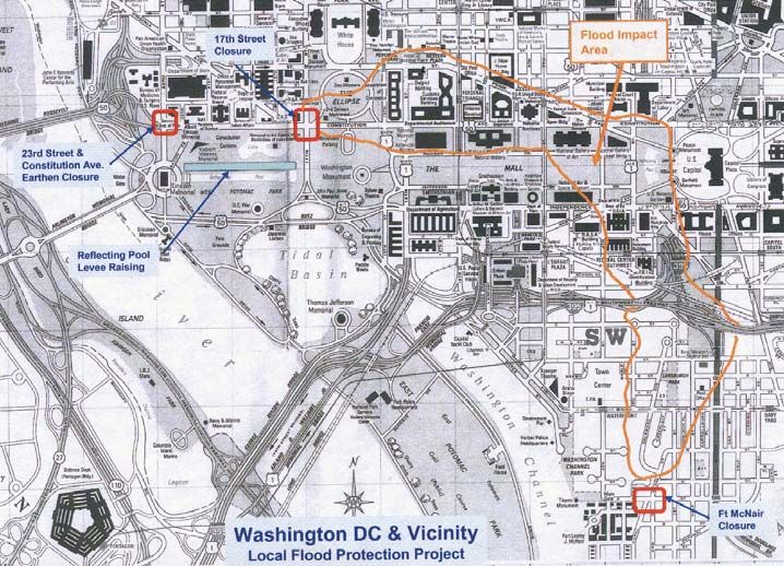
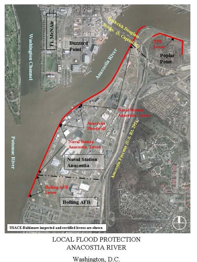
Table of Contents
I. Executive Summary . . . . . . . . . . . . . . . . . . . . . . . . . . . . . . . . . . . . . . . . . . . . . . . . . . . . . . . . . . . . . . . . . . .1
II. Potomac River Flood Risk Overview . . . . . . . . . . . . . . . . . . . . . . . . . . . . . . . . . . . . . . . . . . . . . . . . . . .3
Sea Level Rise
Potomac River
Washington’s Hidden Hydrology
June 2006 Flooding
Causes of the June 2006 Flooding
III. Existing and Proposed Flood Control Measures . . . . . . . . . . . . . . . . . . . . . . . . . . . . . .5
River Overbank Flooding Measures
National Mall Levee
Washington, DC Emergency Flood Procedures
Proposed National Mall Levee Improvement
Urban Drainage Flooding
Tidal Flooding Measures
Flooding Conclusions
IV. What is the Federal Role in Flood Prevention and Stormwater Control? . . . . . . . . .9
National Flood Control
FEMA 100-year Floodplain Maps
Executive Order for Floodplains
The National Environmental Protection Act
The Clean Water Act
Review of National Capital Planning Actions
V. What is the District of Columbia’s Role in
Flood Prevention and Stormwater Control? . . . . . . . . . . . . . . . . . . . . . . . . . . . . . . . . .12
District Stormwater Laws and Requirements
DC Floodplain Requirements
DC Clean Water Act Requirements
Anacostia Waterfront Initiative
DC Flood Emergency Plan
VI. Next Steps/Action Plan for Monumental Core . . . . . . . . . . . . . . . . . . . . . . . . . . . . . .13
Anacostia River
VII. Anacostia River Flood Risk Overview . . . . . . . . . . . . . . . . . . . . . . . . . . . . . . . . . . . . . .14
Anacostia River Hydrology and Geography
Anacostia River Flooding
Hurricane Isabel
VIII. Existing and Proposed Flood Control Measures . . . . . . . . . . . . . . . . . . . . . . . . . . . . .15
Role of the Army Corps of Engineers
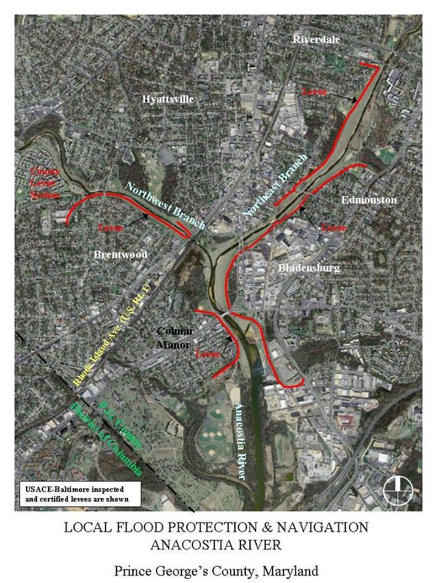
Anacostia River Flood Control Projects
Prince George’s County, Maryland Flood Control Project
IX. Urbanization, Channelization, and Sedimentation Impacts . . . . . . . . . . . . . . . . . . .18
Impacts from Anacostia Tributaries on Flooding
Anacostia Sedimentation
Urban Drainage Flooding
Potential Impacts on Present and Proposed Waterfront Development
X. Restoration and Remediation Efforts . . . . . . . . . . . . . . . . . . . . . . . . . . . . . . . . . . . . . .20
Washington Navy Yard Storm Sewer Rehabilitation
Wetlands Restoration
XI. FEMA Floodplain Map Modernizations . . . . . . . . . . . . . . . . . . . . . . . . . . . . . . . . . . . .21
Revised FEMA Floodplain Maps
XII. Next Steps/Action Plan for Anacostia River . . . . . . . . . . . . . . . . . . . . . . . . . . . . . . . .23
Appendix A: Major Flood Events in Washington, DC . . . . . . . . . . . . . . . . . . . . . . . . . . . . . . . .25
Appendix B: Information on Memorials Submitted to NCPC by NPS . . . . . . . . . . . . . . . . . . .26
Appendix C: Relevant Laws and Regulations for Flooding and Stormwater Management . . . .27
Appendix D: Acronyms and Abbreviations . . . . . . . . . . . . . . . . . . . . . . . . . . . . . . . . . . . . . . . . . 28
Appendix E: Potomac River Flood Stages . . . . . . . . . . . . . . . . . . . . . . . . . . . . . . . . . . . . . . . . . .29
Appendix F: Aerial Maps of Flood Control Projects . . . . . . . . . . . . . . . . . . . . . . . . . . . . . . . . .30
National Capital Planning Commission
Repor t on Flooding and Stor mwater in Washington, DC | Potomac River

                              Effects of flooding on 9th Street, NW in downtown Washington, DC in June 2006.

             National Capital Planning Commission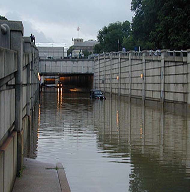
Repor t on Flooding and Stor mwater in Washington, DC | Potomac River

I. Executive Summary                                             property loss and environmental degradation caused by
                                                                 flooding, but Washington, DC poses some unique
At the September 2006 National Capital Planning                  challenges. First, the division of responsibilities among
Commission (NCPC) meeting, the Commission requested              various federal and local authorities is not always clear or
additional information on flooding. This paper provides          uniform, and federal facilities in the business district must
the requested information and recommends the next steps          rely on the local DC government to manage, regulate, and
for reducing the risk of flooding.                               otherwise control stormwater. Second, flooding in the
                                                                 nation’s capital is particularly unacceptable given the
GEOGRAPHICAL FLOODING RISK: The District’s                       hazards it poses to the security of federal buildings and
location at the confluence of the Potomac and Anacostia          our nation’s treasured historic resources.
Rivers, combined with three buried waterways, broad
floodplains, and relatively flat elevations, renders it highly   POTENTIAL ACTION STEPS: There are a number of
susceptible to periodic flooding. A large part of the            strategies NCPC may consider to reduce flooding risks and
National Mall and adjacent areas were originally                 excess stormwater impacts. First, NCPC may review its
underwater and were filled as L’Enfant’s plan was realized.      own agency’s guidelines and policies to increase the level of
Urban development has increased impervious surfaces,             scrutiny for proposals within or near the floodplains.
reduced vegetation coverage, and further exacerbated             Second, NCPC may undertake a number of planning
flooding and stormwater runoff through the entire                initiatives and local and regional partnerships to further
watershed. This problem is especially acute in the National      evaluate flooding and stormwater issues and research new
Mall area given its downstream location.                         and innovative measures for stormwater management.
                                                                 Third, NCPC may encourage more proactive stormwater
NATIONAL MALL LEVEE: To keep water from the                      management tactics to improve the water baseline and
Potomac and Anacostia River systems out of the                   ensure that future development does not exacerbate the
downtown business district, the Army Corps of Engineers          situation. No one solution can eliminate the potential
(ACOE) erected an earthen levee along the north side of          problem entirely, but a strategic combination, weighed by
the mall, running from the Lincoln Memorial to the               the costs and benefits, could help minimize the risk by
Washington Monument. This flood control measure relies           lowering the frequency and magnitude of flooding that
upon temporary closures of several north-south streets,          does occur.
which constitute gaps in the levee. To make the levee more
reliable, ACOE proposes making two of the temporary              At the February 2007 National Capital Planning
closures permanent by extending the levee to meet the            Commission meeting, the Commission requested
higher topography to the north. To ensure the continued          additional information on flooding and stormwater in the
flow of cross-mall vehicular traffic, the 17th Street closure    Anacostia River watershed. This paper provides the
would remain temporary, but the barrier would be                 requested information and recommends the next steps.
redesigned to improve its effectiveness and ease of              In general, Anacostia River flooding is less of a threat to
assembly. Given the prominent location of the levee on           the Washington metropolitan region than Potomac River
the Mall, ACOE’s improvement plan merits a careful               flooding because of the far greater size and reach of the
assessment by NCPC.                                              Potomac watershed, and the volume of water carried by
COMBINED SEWER SYSTEM: Downtown DC suffers                       the Potomac. However, the Anacostia watershed is far
from inadequate storm sewer capacity making the area             more urbanized than the Potomac watershed and as a
especially susceptible to interior flooding. Flooding of the     result of increased impervious surfaces, channelization of
magnitude experienced in June 2006 is costly and can be a        the tributaries, and wetlands destruction, even moderate
security threat if critical building systems are affected and    amounts of rainfall can cause localized stormwater issues.
national historic and cultural resources are threatened.         Sedimentation of the Anacostia River is an ongoing
While flooding in downtown DC is relatively infrequent,          problem with much of the dirt and debris originating
the concentration of key federal agencies and the huge           upstream from Maryland communities. NCPC supports
federal, local, and private costs associated with recovering     the restoration of floodplain values and functions
from even periodic floods warrants a close examination of        whenever possible to mitigate the impact of stormwater
cost-effective solutions. Moreover, future growth will           runoff resulting from increased development and
further strain the system’s already limited capacity.            impervious surfaces.
                                                                 A number of communities along the Anacostia River are
REGULATIONS & RESPONSIBILITIES: Numerous
                                                                 protected by levees. Over the past few years, the ACOE
laws, policies, and executive orders are in place to reduce
                                                                 inspected these levees and has required a number of

                               National Capital Planning Commission                                                              1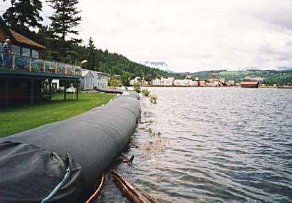
Repor t on Flooding and Stor mwater in Washington, DC | Potomac River

    improvements to ensure that the communities behind the
    levees are protected in the event of a storm. At the same
    time, Federal Emergency Management Agency (FEMA)
    has updated the floodplain maps for the District and
    where the levee improvements have not been completed,
    the proposed floodplain maps have been revised
    accordingly. NCPC strongly supports levee improvements
    and urges the ACOE to coordinate with staff early in the
    design planning process. Further, NCPC urges FEMA to
    ensure that floodplain maps for the National Capital
    Region are updated in a timely manner.
    In the past, Anacostia River flooding has been less
    problematic as most of the waterfront is publicly-owned,
    and a significant portion used as parkland. Recently
    however, there have been a number of private and public
    development proposals submitted for review and approval.
    All new development is required to determine if they are
    within a federally-mapped flood hazard area and if so,
    obtain flood insurance and meet more stringent building
    code requirements. Further, federal actions and approvals
    within the floodplain must comply with Executive Order
    11988 which was designed to minimize the impacts of
    development on floodplains.

2                                National Capital Planning Commission
Repor t on Flooding and Stor mwater Potomac River | Washington
II. Potomac River Potomac River of one foot, combined with a major
storm surge, would make the Jefferson Memorial an
Flood Risk Overview island and flood the National Mall up to the Reflecting
Pool. Hurricane Isabel (2003) produced much more
The District is susceptible to four different types of severe flooding in the region than an unnamed August
flooding, three of which are caused by excess rainfall or 1933 hurricane that was similar in its storm track, tidal
snowmelt, and one by the level of the tide. surge, maximum sustained wind speed, and minimum
pressure, possibly as a result of the relative sea rise of
one foot since 1933.
J OVERBANK FLOODING
Overbank flooding occurs when the river channels receive Washington’s Hidden Hydrology
more rain than they can handle, or when the river channel
is blocked and does not permit the water to flow through. Washington has historically had at least three major
streams––the Tiber Creek, James Creek, and Slash Run.
J URBAN DRAINAGE FLOODING Tiber Creek2 was the largest stream system in Washington,
at one time draining––along with its tributaries––2,500
Urban drainage flooding occurs when the sewer system acres, or nearly 43 percent of the District. Tiber Creek ran
built to handle stormwater runoff is overloaded past its south, beginning near the Armed Forces Retirement
design capacity. Home, through the site of Union Station. Near the East
Building of the National Gallery, it turned west and
J LEVEE-CAUSED FLOODING
roughly ran along Constitution Avenue for the length of
Areas with levees can be inundated behind the levees the National Mall. At the base of the White House lawn,
because they are relatively flat, and the levee serves as a where it met the Potomac River, the Tiber was between
block to the water flowing to the river. Channels may be 700 and 800 feet wide.
built and/or pumps are installed to move the water past
the levee. James Creek, in Southwest Washington, DC, formed near
where the Tiber turned west, and flowed southeast along
J TIDAL/STORM SURGE FLOODING South Capitol Street, broadening into a marshy area and
into the Anacostia River near Fort McNair. Slash Run
Tidal flooding occurs when there is an abnormal rise in was a tributary of Rock Creek and ran roughly south
water level preceding a storm, usually a hurricane, due to down 18th Street, NW and entered Rock Creek near 23rd
the combined effects of wind and low atmospheric Street, NW. 3
pressure. The Potomac, up to the base of Little Falls, is
tidal, which causes the river to rise and fall with ocean
tides. Normal tides have a mean range of three feet, but
have been known to surge as much as 12 feet in a
hurricane.
Major flooding in the Potomac basin occurred in 1889,
1936, 1937, 1942, and 1972. See Appendix A for detailed
flooding history in Washington, DC.
The mouth of the Tiber Creek showing that the White House south
Sea Level Rise lawn, Federal Triangle and Mall areas once were all under water.
Flooding in Washington is exacerbated with higher sea By the 1870s all three waterways were essentially open
levels. According to the U.S. Geological Survey (USGS), sewers and were impounded. The DC Board of Public
Chesapeake Bay sea levels are forecast to rise Works embarked on a massive sewer construction program
approximately one foot over 100 years.1 The American by enclosing the creeks4. Washington’s present-day
Museum of Natural History forecasts that a rise in the hydrologic problems have their roots in the burial of the
1
The observed Chesapeake Bay sea level rate of increase is roughly twice the global average.
2
Local farmer Francis Pope is credited with renaming Goose Creek as Tiber Creek, a more grand designation to better suit his 400-acre farm that he dubbed “Rome.”
3
Note the historical points at which these waterways enter Washington’s Rivers; they indicate the critical points where the ACOE levee protects downtown DC from floodwaters.
4
Sadly, this massive sewer capital improvement system led the District into bankruptcy and caused Congress to take over control of the city. The city was run by a Board of
Commissioners appointed by the President until 1974, when, under the 1973 Home Rule Charter, the city elected a Mayor and City Council.
National Capital Planning Commission 3Repor t on Flooding and Stor mwater in Washington, DC | Potomac River
natural drainage system. Areas in the city plagued by IRS Headquarters Building
chronic water problems can be located by the original
drainage system maps. In 1992, the DC Water Resources The IRS Building sustained the greatest amount of water
Research Center reported that the gravelly deposits of the damage, most likely because it has the lowest elevation.
old creek beds still act as conduits for water, with the result Rainfall flowing down Constitution Avenue spilled into the
that groundwater routinely infiltrates sewer pipes and moats surrounding the building. The IRS subbasement,
building foundations along the former waterways. which holds all of the building’s electrical and maintenance
equipment such as electrical transformers, electrical
switchgears, and chillers, was submerged in over 20 feet of
water. Virtually all major building systems were affected
June 2006 Flooding and most of the equipment either had to be extensively
On June 19, 2006, a wet weather pattern started in rebuilt or replaced.
Washington. Soon thereafter, from June 25 through June The basement flooded with five feet of water. The fitness
27, intense tropical downpours inundated the District. The center, cafeterias, offices, systems furniture, carpet, ceiling
heaviest rainfall fell from early evening on Sunday, June 25, tiles, computer equipment and vehicles garaged in the
through the early morning hours of June 26, with a total
building were all destroyed.
recorded accumulation of 7.09 inches on June 25.
The extensive flooding shut down operations at four key Other Flooded Federal Buildings
federal office buildings––IRS Headquarters, the Commerce
The Smithsonian’s Natural History Museum, American
Department, the Justice Department, and the National
History Museum, the Smithsonian Institution Building and
Archives. Several Smithsonian museums along Constitution
the Castle also were closed. PEPCO shut off power to
Avenue also closed their doors. The National Gallery of
those large government buildings because some basements
Art closed due to a weather-related steam outage, and the
containing electrical switch gears were flooded, and the
National Zoo banned cars because of flooding in the
buildings all share the same electricity network. The
parking lot. Rock Creek Parkway became impassable and
National Gallery of Art also closed because flooding cut
had to be closed when Rock Creek overflowed its banks
off the building’s steam supply, which maintains air
and flooded the road.
humidity levels necessary to preserve the artwork.
National Archives Building
Causes of the June 2006 Flooding
Constitution Avenue flooded on Sunday evening, June 25.
Rainwater poured down the driveways of the 7th and 9th Shortly after the June flood, the General Service
street sides of the building and flooded the transformer Administration (GSA) retained an independent, private
vaults and the subbasement areas. The two transformer consultant to ascertain its causes and to recommend
vaults were submerged in up to eight feet of water. solutions to prevent future flooding. The study was
recently completed, although the results are not public.
The freshly renovated (2004) William McGowan Theater, GSA summarized the report so that we could include the
located under the Constitution Avenue steps, was also consultant’s initial findings here.
significant damaged. Flood water flowed down the
theater steps, submerging the stage and the first two rows In short, after interviewing DC WASA, the GSA
of seats. Electrical power went out immediately, but the consultant was unable to determine conclusively why the
sprinkler and security systems remained operational. Federal Triangle area flooded so badly and so quickly. DC
Sump pumps continued to operate because of the WASA was unable to provide an explanation as to why the
emergency generator, but they were overwhelmed and flooding occurred. In categorizing the rain event, the
had no place to pump the water. Fortunately, no original consultant determined that over a 24-hour period the
records were affected by the flood. rainfall was equivalent to the expected rainfall for a 50-year
storm event. However, over the most intense 6-hour
period of the storm, the rainfall was equal to a 200-year
storm. The capacity of the DC sewer system in the Federal
Triangle area is unknown, as it was constructed before
such standards were typically adopted.5 As a result, it would
be easy to conclude that the storm exceeded the capacity
4 National Capital Planning CommissionRepor t on Flooding and Stor mwater in Washington, DC | Potomac River
This ACOE map depicts the area of
Washington, DC protected by the
National Mall levee.
of the sewer. However, the consultant noted that flooding
started before the rainfall should have exceeded the sewer’s III. Existing and
capacity. In addition, when the flooding dissipated, it also
did so at a speed greater than what would be expected. Proposed Flood Control
Power outages caused the 12th Street pumping station to
be inoperable, but DC WASA concluded that while a fully-
Measures
functioning pumping station would have offered some
relief, it would not have completely ameliorated the severe River Overbank Flooding Measures
flooding. The main pumping stations were operational
during the entire storm. The Potomac River remained Washington, DC is particularly susceptible to overbank
below flood stage during the entire storm, so backflow was flooding in Potomac Park, along the Tidal Basin, and over
not a contributing cause to the interior flooding. the National Mall area up to the Reflecting Pool. These
areas have the lowest elevations in DC. Most of the area
In summary, the flooding may have been caused by the with the highest risk of river overbank flooding is parkland
extreme intensity of the rainfall over a very short period of under the jurisdiction of the National Park Service (NPS).
time, but no one can be sure. The report to GSA includes
recommendations for future flood prevention at each of
the buildings that flooded. The report and these
recommendations are under consideration by GSA National Mall Levee
management.
As a result of the 1936 Great Flood in Washington,
Congress passed the Flood Control Act of 1936, which
authorized the ACOE to design a solution to overbank
flooding on the National Mall. In response, ACOE used
landfill from the Reflecting Pool to create a levee between
the Lincoln Memorial and the Washington Monument.
The project began operation in 1940 to protect against a
flood discharge of 700,000 cubic feet per second (cfs) on
the Potomac River.6
5
Well after most of the sewers in downtown were constructed, DC WASA’s predecessor agency established a 15-year storm as the design standard for the system. New sewer
construction is designed to this 15-year standard.
6
It is estimated that the Potomac River’s discharge during the 1942 Great Flood was 450,000 cfs when the maximum flood stage was attained. The maximum discharge of record
for the Potomac River is 484,000 cfs, which occurred in March 1936. ACOE estimated that an overbank flood of 700,000 cfs has a larger percentage chance of annual occurrence
(two percent) than the 15.0-foot tide, which has less than a one percent change of annual occurrence. Consequently, Congress deemed that the ACOE Washington, DC flood
control measure (the levee) should be built to the 700,000 cfs design standard. According to USGS, the maximum tidal gauge height was recorded at 17.72 ft (DC MLW) on Oct.
17, 1942.
National Capital Planning Commission 5Repor t on Flooding and Stor mwater in Washington, DC | Potomac River
According to ACOE, a considerable portion of the levee construction is complex and requires significant
was removed during World War II for Navy Department construction equipment and embankment material and has
construction. Consequently, it is necessary to construct as the greatest potential for failure.
much as 1,500 feet of temporary levee in three segments
in the event of a major overbank flood to provide Fort McNair - The DC Emergency Management Agency
protection to the height of the permanent works now in (EMA) is responsible for the Fort McNair sandbag closure
place. See the map on page 5, which illustrates the areas at P and Canal Streets when the Wisconsin Avenue river
protected from flooding by the current levee when the stage exceeds 23-feet MLW.
temporary closures are in place.
Washington flooded again in 1942. Congress then passed
Proposed National Mall Levee
the Flood Control Act of 1946, which authorized
improvements to the levee to restore the level of Improvements
protection and improve the levee’s operation. The levee’s In 2000, ACOE proposed making the temporary closures
overall effectiveness depends on implementing the 1946 at 23rd Street and Fort McNair permanent to improve the
improvements; however, ACOE has not completed the levee’s design and reliability. At 23rd Street, the Corps
improvements because Congress has not funded them. proposed a 600-foot earth embankment with a maximum
At present, the project is unable to provide the level of height of 3 feet that would run along 23rd Street until it
protection it was designed to provide because in a flood met the existing embankment for the Route 50 ramp. The
emergency the levee’s effectiveness relies on timely, topographic modifications would then complete the
complete, and correct construction of the three protection line at 23rd Street. At Fort McNair, the Corps
temporary barriers. proposed a permanent earth berm that would be 1.2 feet
high and extend for 570 feet.
The closure at 17th Street, NW remains temporary, but
Washington, DC
will be redesigned to improve its reliability and minimize
Emergency Flood Procedures the construction time needed during floods. Presently,
In the event of a storm, National Weather Service (NWS) there are a number of options being considered. One
forecasts are posted on the Washington Area Warning alternative is a “borrow pit.” The Corps would excavate a
Alert System (WAWAS) and the National Oceanic and portion of the Mall near 17th Street so that the hole could
Atmospheric Administration (NOAA) Weather Radio be refilled with aggregate material. During a storm event,
whenever a Potomac River Stage of 7.0 feet mean low NPS staff would excavate that specific location of fill and
water (MLW) or greater is predicted at the Wisconsin use it to create an earthen dam across 17th Street. A
Avenue gauge. Currently, the National Park Service (NPS) second alternative is an inflatable dam, known as an
is responsible for the 23rd Street and 17th Street aquadam [See below]. A third similar option is a
temporary closures in the National Mall levee. cofferdam, which is an A-frame structure that is erected
with a light-weight steel frame and covered with a plastic
23rd Street Closure: NPS is to construct the emergency membrane. [See below] Last, the Corps is considering a
levee at 23rd Street when the Potomac River Stage of “post and panel” temporary dam.
19.0 MLW or greater is predicted at the Wisconsin
Avenue gauge. The Corps also proposes to fortify the portion of the
levee along the Reflecting Pool by eliminating low spots.
17th Street Closure: NPS is to construct the temporary
levee at 17th Street. The 17th Street closure consists of When all of the modifications are complete, the levee
two structures constructed in two phases. Phase One is a would have less than a one percent chance of being
3-foot high jersey wall barrier with sandbags and plastic overtopped in any one year. The modifications will bring
sheathing and is triggered when the Potomac River is the top of the existing levee along the Reflecting Pool
projected to rise to flood levels over 10.4 feet MLW. Phase (between 23rd and 17th Streets) to a uniform elevation and
One can be put into place relatively quickly, and provides increase the level of freeboard7 protection provided.
protection up to 15.42 feet MLW. Phase Two is a
temporary earth levee located 50-feet north of the Phase
One closure and should be initiated immediately after the
river exceeds elevation 11.42 feet MLW. Phase Two
7
“Freeboard” is the vertical distance between the normal maximum level of the water surface in a channel, reservoir, tank, canal, etc., and the top of the sides of a levee, dam,
etc. It is provided so that waves and other movements of the liquid will not overtop the confining structure.
6 National Capital Planning CommissionRepor t on Flooding and Stor mwater in Washington, DC | Potomac River
The pictures above depict temporary dams, an inflatable dam (left) and a port-a-dam (right).
ACOE is waiting for Congress to appropriate construction First, excess stormwater causes untreated wastewater to
funding for the project. The estimated total cost is $7 flow directly into nearby rivers. Such discharge of the
million; the project has received just over $3 million in prior untreated stormwater is a violation of the Clean Water Act
funding. ACOE estimates that without the levee closures a and consequently, the District is under a consent decree to
major flood could cause more than $200 million in damages construct storage tunnels to hold the excess untreated
to museums, memorials, and office buildings. The flood water. The consent decree imposes a 20-year
control project requires NCPC review and approval. implementation schedule for construction to be complete;
however, funding is a significant issue.11
ACOE has not yet completed final designs or construction
plans for the two permanent closures and the enhanced The project is estimated to cost $1.9 billion and current
17th Street temporary closure. However, given the levee’s proposals provide that the entire cost be borne by the
prominent location along the National Mall, staff believes ratepayer base. Presently, DC WASA’s storm-related
ACOE’s plans will warrant a close review to ensure that activities are funded solely through water and sewer fees.12
the proposal does not adversely affect the National Mall
and its environs. DC WASA estimates that to finance baseline capital
improvements and maintenance, in addition to the long-
term plan for the combined sewer overflow (CSO), rates
would need to rise annually, with at least eight rate
Urban Drainage Flooding increases above 10 percent per year for DC WASA to
raise sufficient capital. DC WASA has calculated that if it
Urban drainage flooding is typically caused by sewer
receives 62 percent of the capital costs (approximately
overflows and thus is the responsibility of the DC
$960 million) from external sources (e.g. the federal
government.8 One-third of the District, including the
government) that the agency would likely be able to keep
entire downtown business district, has a combined
rate increases at no more than 8 percent per year.
sanitary and storm water system.9 In other words, a single
Congress has made a number of dedicated
pipe carries both raw sewage and stormwater to the Blue
appropriations to DC WASA that currently amounts to
Plains treatment facility. When it rains, the combined
approximately $35 million.
wastewater flow can easily exceed the capacity of the
combined sewer system and/or the treatment facility. 10 Second, excess stormwater may be so great that that the
Two harmful things can occur if the capacity of the sewer system can not even collect it, and then it floods the
system is exceeded. streets. The storage tunnel solution described above would
not prevent street flooding caused by excess rainfall
because the capacity of the sewers under the streets
8
DC WASA sent comments to NCPC’s draft report, noting that “urban flooding can be caused by many factors including: improper grading; inadequate location, number or size of
catch basins; clogged catch basins; inadequate sewer capacity, and storms which exceed the design capacity of the system. Some of these are the responsibility of the DC
Government, while others are the responsibility of DC WASA or private landowners. Other factors are caused by nature and are not the responsibility of any entity.”
9
Combined sewer systems, introduced in 1855, were a vast improvement to the open cesspools originally used to convey wastewater, and are common in most older cities. As a
result, many cities still struggle with the attendant pollution from combined sewer overflows.
10
Combined sewer overflows (CSOs) should occur only during wet weather. However, according to DC WASA’s overflow predictions, in an average year, less than 0.5” of rain can
cause more than 3 hours of untreated sewage to flow into the Anacostia River. Such an occurrence is predicted to occur more than 50 times in an average year.
11
The consent decree was entered March 23, 2005.
12
Typically, in other cities, the costs of municipal stormwater programs are funded through a combination of real property taxes, general revenues, and user fees.
National Capital Planning Commission 7Repor t on Flooding and Stor mwater in Washington, DC | Potomac River
remains unchanged.13 The storage tunnel merely holds the Tidal Flooding Measures
water for future treatment once it is in the system; not
increase the actual capacity of the old receiving sewer Washington is also susceptible to tidal flooding and tidal
tunnels. surges. Tidal flooding in the Potomac River can be
caused by hurricane tidal surges that form in a number of
One additional predicament is that when the river level ways. The surges produce the highest water levels in the
rises above the outfall pipes, water can back up into the upper Potomac when they coincide with the astronomical
system and cause reverse flooding. This should be resolved high tide.
by the gates that DC WASA installed at the outfall pipes,
but there have been problems with the gates in the past In 1955, a year after three successive hurricanes ravished
either being open during a storm or not functioning the northeastern seaboard, Congress directed ACOE to
completely. The tide gates at the outfall pipes specifically evaluate cost effective structural measures to reduce the
prevent backflow of river water to Blue Plains Wastewater human and property losses from future hurricanes. ACOE
Treatment Plant during high river levels. This protects the prepared a report that evaluated the risk of tidal flooding
plant against treating extraneous river water. However, tide in the Washington, DC metropolitan area and concluded
gates are not typically relied upon to protect life or that while the area was vulnerable to severe damage from
property during river floods. hurricanes, the relief from tidal flooding by structural
means could be accomplished by protective works needed
In those situations, a positive means of shutting off flow is for overbank flooding control.
used, such as sluice gates or stop logs. For example, in the
current ACOE Flood Emergency Manual for DC, The report concluded that effective zoning was the most
locations are identified where stop logs are to be inserted important solution for reducing flood hazards:
in sewers to prevent backflow during river floods.
The continuing encroachment on the tidal flats and floodplains of
ACOE developed a map to illustrate the areas that would the Potomac River in the Washington area has seriously reduced
experience street flooding in a storm event that produced the capacity of the stream to pass fluvial floods and absorb tidal
rainfall greater than what the sewer system could handle. floods without losses. Zoning regulations to stem the encroachment
The ACOE map below delineates the flooded areas on the waterfronts and to establish future structures at safe
corresponds almost exactly to the areas that flooded in elevations are needed.
June 2006. Consequently, it appears that interior flooding is
ACOE has not reevaluated Washington tidal flooding since
a separate, persistent issue that needs a separate solution.
the original report, completed more than 50 years ago.
1990 ACOE MAP SHOWING AREAS OF RESIDUAL FLOODING
13
For the Northeast Boundary area, the proposed CSO tunnels have a dual purpose: CSO control and
flood relief. The LTCP is designed to provide flood relief to known flood areas in Northeast Boundary.
8 National Capital Planning CommissionRepor t on Flooding and Stor mwater in Washington, DC | Potomac River
Flooding Conclusions
IV. What is the Federal
The most frequent types of flooding in Washington, DC
are the consequences of river overflow and urban drainage Role in Flood Prevention
failures. Excess stormwater can trigger either type of
flooding, but they occur independently. Overbank flooding
and Stormwater Control?
is an easier risk to manage because fairly reliable warning The full panoply of floodplain laws, regulations, executive
systems typically provide longer lead times before the orders, policies, and agency guidance, implemented over
flooding begins. For example, the average rate of flood the past 100 years on federal, state, and local levels, is
crest travel time from Point of Rocks, MD to the complex, comprehensive, and somewhat disjointed. [See
Wisconsin Avenue gauge is approximately 11 hours. Urban Appendix C for a chart of the relevant federal laws.] The
drainage flooding, however, provides emergency workers National Flood Insurance Program (NFIP), implemented
with less advance warning since the onset of urban by FEMA, is the most well-known federal flooding statute.
flooding is harder to pinpoint reliably, as illustrated by the The 100-year floodplain maps and the federally-mandated
June 2006 flood. and subsidized insurance program are the hallmark of
NFIP. However, there are a number of other federal
A number of factors unique to DC make flood control
statutes and requirements that also play a role and these are
and stormwater management more vexing. First, while
discussed in more detail below.
many of the riparian areas in DC are parklands that retain
some of their natural floodplain functions, many priceless In addition to federal laws and regulations, the District has
monuments, museums, and national structures are located its own responsibilities and rules. Some of the local rules
in areas likely to flood. Many monuments are designed to are federal requirements, such as the building regulations
withstand intermittent flooding, but clean-up can be costly for construction in a FEMA-designated floodplain, while
and the impacts of repeated flooding may compound over others, such as the Anacostia Waterfront Initiative’s
time. For other structures, flooding can be devastating and stormwater regulations, are entirely local requirements.
irreversible, as would have been the case at the National
Archives if the agency had been unable to mitigate the
June 2006 flooding.
National Flood Control
Second, the federal government is the largest developer,
tenant, and property owner in downtown DC. This NFIP is the key federal statute with regard to flooding.
creates a significant federal interest in the cause and effect Under NFIP the federal government accepts a significant
of flooding. share of the responsibility for flood prevention, control,
emergency response, and property loss. The statute’s
Moreover, a significant amount of stormwater in this area underlying principle is that there should be development
is routinely generated through runoff and de-watering at restrictions within the floodplain for the dual purpose of
federal facilities. The federal government may, over time, reducing flood damage losses and minimizing disruption
be able to address some of the issues of peak period and to the floodplain’s natural function of storing excess water
overall runoff through individual and coordinated design and draining water over land areas and into the floodway.14
and operational actions. These actions may also support NFIP directs FEMA to develop maps nationwide that
larger federal goals supporting green building and delineate the floodway and the floodplain.15 A Flood
environmental objectives. Insurance Rate Map (FIRM) is the official map on which
FEMA has delineated both the special flood hazard areas
Lastly, the responsibilities and jurisdiction for addressing and the flood risk premium zones applicable to the
stormwater and flooding in the District, and specifically in community. Structures built before the FIRM or before
the downtown area, are complex. Many possible solutions, 1975, whichever is later, are eligible for flood insurance
whether structural changes to the sewer system, or using with premiums that are reasonable, and if necessary,
low-impact development or green building design federally-subsidized.16
strategies, are costly or beyond the ability of a single
jurisdiction to require. Therefore, developing coordinated
and comprehensive strategies will require coordination
between federal and local agencies alike.
14
“Floodway” means the regular channel of a river, stream, or other watercourse, plus the adjacent land areas that must be
reserved in order to discharge the base flood without cumulatively increasing the water surface elevation more than one foot.
15
“Floodplain” means the low area of land surrounding water bodies that holds the overflow of water during a flood.
16
“Consequently, NFIP is one of the largest domestic fiscal costs along with Social Security, Medicare and Medicaid.
National Capital Planning Commission 9Repor t on Flooding and Stor mwater in Washington, DC | Potomac River
Typically the maps are developed in conjunction with the Development and impervious surface coverage within the
local government. Buildings within the floodplain must watershed has been sizeable, which could also easily
obtain private flood insurance. Flood insurance eligibility is require a change in the delineation of the floodplain area.
based on communities adopting development restrictions In March 2005, the Maryland Department of the
that meet minimum federal requirements. Environment completed a study determining that:
In flat areas, structures located within several hundred feet
or more horizontally of the 100-year floodplain line may
FEMA 100-Year Floodplain Maps also be at risk.17
An enduring problem nationwide is that the FEMA-issued However, the DC floodplain delineations will not be
flood insurance maps are out-of-date. The District maps revised to reflect any changes in sea level or development
are approximately 21-years old. in the watershed as part of the digitalization process. The
DC Flood Emergency Manual contains maps prepared by
The DC Department of the Environment (DCDOE)
the Corps delineating the area ACOE predicts will flood
and FEMA are digitizing the 1985 DC floodplain maps.
for the 100-year storm. (See Corps map that is attached to
Once the maps are complete, the agency will schedule a
the report.) The inundated area is larger than the FIRM’s
public hearing and then they will be sent to the DC City
100-year boundary, and more closely corresponds to the
Council for adoption. The process that leads to final
FIRM’s 500-year floodplain line.
adoption can last as long as a year. Once the maps are
adopted, new flood insurance requirements become
effective.
DC 1985 Flood Insurance Rate Map
ZONE A: Would flood in 100-year event ZONE B: Would flood in 500-year event
17
Emphasis added.
10 National Capital Planning CommissionRepor t on Flooding and Stor mwater in Washington, DC | Potomac River
Executive Order for Floodplains The National Environmental
Protection Act
In 1977, President Carter, faced with ever increasing flood
costs, issued Executive Order (EO) 11988 to hold federal The NEPA also plays a role in flooding, floodplain
agencies to a higher standard than the NFIP rules. management, and stormwater control. NEPA requires
federal agencies to assess potential environmental impacts
Executive Order 11988 affirms that the federal
before undertaking any federal building projects or site
government should not encourage floodplain development
changes that significantly affect the quality of the human
in all of its actions and funding mechanisms. The
environment. The environmental review should discuss
President’s statement that accompanied the EO noted that
whether any proposal would be affected by flooding, as
flood losses and adverse alteration to floodplains arise
well as whether the proposed action would likely increase
mainly from “unwise land use practices.” Further, it states,
flooding. Floodplain development is typically scrutinized
“Floodplain development … is simply a bad Federal
more closely for adverse impacts than development
investment and should be avoided.” The EO required all
outside the floodplain. Stormwater runoff and its
executive branch agencies to develop compliance
potential impacts are also likely to be part of an
procedures. As a result, on September 17, 1981, NCPC
environmental review assessment. In general, the
adopted floodplain management procedures that apply to
submitting agency is responsible for ensuring that a
all actions that “have the potential for adversely impacting
thorough and comprehensive environmental assessment is
floodplains…or which are subject to potential harm by
completed for each proposed action, and that alternatives
location in floodplains.” According to the procedures, if
are considered, before final action is taken. However, as a
NCPC finds that an action meets the above test, then the
federal agency, NCPC has an independent obligation
Commission is required to (1) identify the full range of
under NEPA to assure this information is available before
potential direct or indirect adverse impacts, and (2) identify
it makes any decisions about a project. Moreover, when
and evaluate practicable alternatives outside the floodplain
analyzing the proposal and alternatives, federal agencies
including the “no action” alternative. The procedures
must consider the direct or indirect consequences––that
require public notice for any plans, proposals, or actions in
is, connected, similar, and cumulative actions. These
floodplains followed by a 30-day review and comment
actions should be incorporated into the description of the
period. A Statement of Findings is required for all plans,
proposal and alternatives.18
proposals, or actions in floodplains and must include why
the action is proposed to be in the floodplain; whether the The Clean Water Act
action conforms to applicable state and local floodplain
management standards; the list of alternatives considered, The Clean Water Act (CWA) regulates stormwater
a list of mitigation measures; and a map delineating the discharges from industrial activities (which include
proposal’s location and its relationship to its environs. construction activities and municipal sewer system
discharges) under the National Pollutant Discharge
NCPC’s procedures also amend NCPC submission Elimination System (NPDES) permit program. NPDES
guidelines for federal agency projects to require a copy of regulates water quality. Municipal sewage system operators,
the submitting agency’s Statement of Findings pursuant to private developers, and the federal government are all
EO 11988 if the proposed project is within a floodplain. required to comply with the NPDES permitting program.19
In theory, the National Environmental Protection Act EPA administers the CWA and NPDES program and in
(NEPA) environmental review can satisfy many instances delegates permitting authority to the
the EO’s requirements. However, to avoid floodplain states. However, the District is not a delegated state and
harm, the EO requires more affirmative action than EPA retains NPDES permitting authority with regard to
NEPA. both construction activities and municipal sewer
discharge in DC.20 For construction, stormwater runoff is
regulated both during construction and after construction
is complete. Consequently, a developer in DC is required
to prepare a stormwater pollution prevention plan in
accordance with the EPA General Permit, submit the
18
For an EIS, 40 CFR § 1502.16 which incorporates the definitions from 1508.7 and 1508.8 and for an ES, 1508.9(b) which also incorporates the definitions from 1508.7 and 1508.8.
Also, see generally NCPC Environmental Submission Guidelines Section 10 and Appendix B, Section 3(A).
19
The CWA specifically mandates that all departments or agencies of the executive, legislative, and judicial branches of the federal government comply with Federal, State,
interstate, or local stormwater regulations. Further, EO 12088, “Federal Compliance with Pollution Control Standards,” directs each executive agency to develop annual plans for
the control of pollution and to ensure that sufficient funds for compliance are requested from OMB in the agency budget.
20
In fact, the consent decree for the sewer storage tunnels was developed to settle an enforcement action brought by the United States against DC WASA because it is in violation
of the NPDES permit EPA issued to it.
National Capital Planning Commission 11Repor t on Flooding and Stor mwater in Washington, DC | Potomac River
plan to EPA, and file a notice of intent to start of Transportation (DDOT). Recently, DC DOH’s flood
construction. The stormwater plan governs runoff for and watershed responsibilities, including stormwater, were
the period of construction and then for the building once transferred to the newly formed Department of the
construction is complete. Environment (DC DOE). In February 2007, DC DOE
will take over all responsibilities of managing the MS4
permit-related activities (described below) that DC WASA
previously handled.
Review of National
Capital Planning Actions DC DOE is responsible for monitoring water quality in
the Anacostia and Potomac Rivers. DC DOE is also
Staff reviewed a number of executive director’s reports responsible for reviewing developers’ plans for compliance
and environmental documents prepared for projects in the with DC’s stormwater management and erosion and
monumental core to better understand how flooding and sediment control regulations, monitoring implementation
stormwater issues have been considered. While many, but with management plans through inspections, and
not all, of the documents do include information on investigating illegal discharges to the sewers. Developers
stormwater and flooding issues, the analyses have not cannot obtain a building permit from the Department of
always been consistent in either the range of issues Consumer and Regulatory Affairs (DCRA) until DC DOE
reviewed, the scope of the evaluation, or the final ascertains that the developer has complied with DC
conclusions reached. Further, the analyses that we stormwater rules. Construction activities that do not
reviewed focused on specific impacts to projects, and there disturb more than 5,000 square feet of land area are
was typically little discussion on how development might exempt. Federal agencies follow the same procedure as
increase the likelihood of flooding. We have not identified private entities to comply with DC’s stormwater rules.
any documents discussing the cumulative impact of Federal agencies, such as GSA, submit their stormwater
development on stormwater and flooding in this area. management plans to DCRA for DC DOE to review and
In addition, to assist our review, the National Park Service approve the plan, even though GSA does not ultimately
provided details to NCPC on how a number of memorials need a local building permit.
located within or near the floodplain have dealt with Stormwater plans must meet several requirements,
potential flooding issues (See Appendix B). We also spoke including an important directive that stormwater flow from
with a number of federal agencies regarding flooding and the site will not increase after development over the pre-
stormwater, and found that all of the agencies were aware construction baseline.
of flooding and stormwater issues specific to their own
facilities. Many of the agencies expressed an interest in DC WASA is responsible for maintaining the District’s
better understanding how other agencies were addressing sewer system, and cleaning the catch basins.
flooding and stormwater, as well as looking more
comprehensively at the issue in the downtown area.
DC Floodplain Requirements
V. What is the District of The District promulgated development regulations, known
as the DC Flood Hazard rules, for buildings proposed to
Columbia’s Role with be constructed in a floodplain.23 These rules, mandated
Regard to Flood Prevention by NFIP for a community to be eligible for federal flood
insurance, restrict uses, activities, and development in areas
and Stormwater Control? subject to flooding (generally within the 100-year
floodplain). If development is permitted in an area likely to
District Stormwater Laws flood, it must be flood-proofed. The Flood Hazard rules
are triggered when an applicant seeks a building permit in
and Requirements
the District.
In the District, stormwater management is a responsibility
shared jointly among four District agencies: the DC
Department of Health (DC DOH), the DC Water and
Sewer Authority (DC WASA),21 the DC Department of
Public Works (DC DPW),22 and the District Department
21
Unlike the other three agencies, DC WASA is an independent authority that was formed to assure that the money collected
for the purpose of maintaining the water and sewer system would not be transferred into the DC General Fund.
22
DC DPW’s responsibility is primarily street sweeping, waste collection, litter control, and road repair.
23
As approved by FEMA.
12 National Capital Planning CommissionRepor t on Flooding and Stor mwater in Washington, DC | Potomac River
DC Clean Water Act Requirements With or without the ACOE proposed modifications, urban
drainage flooding nonetheless remains an unmitigated
The District is required to obtain two NPDES permits flooding risk.
for its stormwater discharge as a municipality: one for the
Municipal Separate Stormwater Sewer System (MS4)
which drains storm water from approximately two-thirds
of the city into the rivers, and one which covers the Blue
Plains Wastewater Treatment Plant and the combined
VI. Next Steps/
sewer system. Action Plan for
Monumental Core
Anacostia Waterfront Initiative In short, our research led us to three key conclusions. First,
The Anacostia Waterfront Corporation (AWC) had while the definitive cause of the June 2006 flooding may
proposed additional stormwater requirements that are not be determinable, the rainfall totals in Washington, DC,
stringent and comprehensive. AWC proposed that any were extraordinary and at times equal to a 200-year storm
development that receives AWC financing or is on AWC- event. However, even though the rainfall was much greater
controlled property must adhere to stringent stormwater than normal, it exposed our second finding––that flooding
guidelines, which require retention and on-site reuse of poses a risk to the federal government in the Federal
stormwater. Since the initial publication of this report, the Triangle and National Mall areas. Flooding is a risk to the
AWC was absorbed into the District Office of Planning. national cultural and historic resources in the area, a
The federal government’s stance on the more stringent financial risk for the property damage, and a security risk
guidelines has not yet been determined. given the concentration of key federal functions. Last, even
in amounts far below flood stage levels, stormwater
DC Flood Emergency Plan control is an ongoing issue for which there is not a long-
term federal or local management plan in this important
Atypically, the ACOE developed the Flood Emergency area. NCPC could play a leadership role in the
Plan for the District. Generally ACOE is responsible for development of such a plan, if the Commission chooses.
developing emergency flood plans for the dam structures; At a minimum, the Commission can consider revisions to
while the local government entity is responsible for our project review procedures and adding stormwater
developing a local flood emergency plan. The first DC considerations to our relevant planning initiatives.
plan was developed in the late 70s and is revised
periodically. 24
ACOE is responsible for flood control measures
nationwide, and consequently has designed and provided
construction oversight of the National Mall levee since
Congress authorized it. FEMA recently asked ACOE to
certify the levee as the line of delineation for the 100-year
flood event. The significance of this certification is that
private development on the other side of the levee (in the
downtown district) would not need to obtain flood
insurance and would not need to meet the DC Flood
Hazard regulations.25 While ACOE has not responded
officially in writing, ACOE stated it will not certify the
levee to FEMA because it believes the temporary closures
do not sufficiently ameliorate the flooding risk. Once the
ACOE decision is transmitted in writing it is likely that
there will be increased pressure on Congress to fund the
permanent levee closures so that ACOE can certify the
levee and exempt private development from needing flood
insurance and flood-proofing requirements.
24
DC reviews the ACOE Flood Emergency Plan and may provide input to ACOE.
25
Recall that ACOE was criticized heavily for certifying the levees in New Orleans. Consequently, many of the homes that flooded after the levees failed did not have insurance
because it was not required. Certification deemed them “outside” the 100-year floodplain and they were believed to be safe from flooding because the levees would protect them.
National Capital Planning Commission 13Repor t on Flooding and Stor mwater in Washington, DC | Anacostia River
VII. Anacostia River Today, the hydrology of the Anacostia tributary system is
“flashy” (i.e., it has a quick flow response to rainfall) with
Flood Risk Overview intense flow conditions even in moderate rainfall events.
Channelization of the Anacostia’s tributaries, along with
urbanization, results in higher runoff volumes that flow
quickly into the mainstem. Conversely, in dry weather, the
Anacostia River Hydrology tidal river portion is sluggish, and water can languish for
and Geography 100 to 110 days in drought periods. Average daily inflow
into the tidal river is approximately 138 cubic feet per
The Anacostia River originates in Bladensburg, Maryland, second (roughly 61,934 gallons per minute).
where the Northwest and Northeast Branches meet, and
flows southward for 8.4 miles until it runs into the
Potomac River at Hains Point in Washington, DC. The
Anacostia is tidal from its headwaters, and has a 2.9-foot Anacostia River Flooding
average tide. It flows languidly toward the District, and In comparison to the Potomac River, there is less historical
with a 0.22 percent average mainstem gradient it can take flood data and river flow measurements for the Anacostia
more than 30 days for water to flow from Bladensburg to River because the Anacostia is tidal for its entire length.
the Potomac. As a result of the sluggish flow, sediment, Due to the tidal effect on the Anacostia River’s water level,
debris, and pollutants are not easily flushed downstream. the USGS can not collect stream flow data from the river’s
The Anacostia watershed is small and highly urban. The rise in the way that it is collected for a non-tidal river
watershed spans approximately 170 square miles in its channel. USGS is currently experimenting with new and
entirety (compared to the Potomac watershed which innovative ways to measure stream flow in tidal river
covers 14,679 square miles), 120 miles of which are channels, such as using acoustics to measure velocity and
located in Prince George’s and Montgomery counties, with calculate stream flow on tidal rivers. However, these new
the remainder in the District of Columbia. The watershed methods have not yet been implemented along the
is home to more than 800,000 residents, and is one of the Anacostia. Second, there are only three river gauges in the
most urbanized watersheds in the United States. entire Anacostia watershed, one for the Northeast Branch,
Urbanization and other impacts have altered the Anacostia one for the Northwest Branch, and one in Watts Stream
River and its tributary streams causing floods to be 10 (located 200 feet upstream from Minnesota Avenue). In
times more frequent and summer flows much lower than addition, USGS reports that the costs of their research and
historical statistics. 26 data collection efforts are typically funded 50 percent by
the local jurisdiction, and the District has neither requested
According to the ACOE, the federal government owns 17 nor funded research and data collection for the Anacostia
percent of the land in the watershed. However, in the River to the extent that other local jurisdictions have
District more than 90 percent of the river’s immediate requested data for the Potomac River.
shoreline is in public ownership, with the National Park
Service (NPS), the Navy Department, the General Services According to the USGS, another reason for extensive
Administration (GSA), and the District as the major research and data on the Potomac River is that the
landowners. Potomac is considered the “big gorilla” of the
Washington metropolitan region.27 Flooding along the
Historically, the Anacostia was broad, deep, and Anacostia River usually only occurs when the Potomac
meandering with thousands of acres of fully functional floods and not independently. Potomac River flooding,
freshwater tidal marshes. In 1790, Bladensburg was a because of the far greater size and reach of its watershed
deepwater port receiving ocean-going vessels. But less than and stream volume, is a far greater threat to its
100 years later, sediment from agricultural activities in the surrounding area. Therefore, it has been monitored more
surrounding area clogged the river channel and closed the closely in the past. Storm events that cause flooding
river to navigation. along the Potomac River will affect the Anacostia River
and cause flooding in the Anacostia watershed.
During the past century, channel dredging and the Therefore, research and monitoring of the Potomac
consequent wetlands “reclamation” significantly altered the informs expected flooding on the Anacostia, making
tidal river system’s morphology. A stone seawall was built Anacostia River monitoring somewhat redundant.
along much of the river’s edge creating a hard line between Moreover, during a storm, the flooding on the Anacostia
the dredged river channel and the deposited fill material River will subside more quickly than along the
behind the seawall. Potomac River.
26
USGS “Effects of Urban Development on Floods,” Fact Sheet FS-076-03 November 2003.
27
Phone interview with Dan Souder of USGS.
14 National Capital Planning CommissionYou can also read