An Introduction to Marine Resources in Tai Tokerau - with Examples from the Whangarei Region - Brenda Hay & Coral Grant - The ...
←
→
Page content transcription
If your browser does not render page correctly, please read the page content below

An Introduction to Marine
Resources in Tai Tokerau
     with Examples from
    the Whangarei Region

  Brenda Hay & Coral Grant
   of AquaBio Consultants Ltd.
An Introduction to Marine Resources in Taitokerau, with Examples from the Whangarei
Region
by Brenda Hay and Coral Grant

This publication has been prepared as part of the Research Programme on Sustainable Mäori
Development in Taitokerau conducted under the aegis of

The James Henare Mäori Research Centre
The University of Auckland
Private Bag 92-019
AUCKLAND

This PDF version of the report is made available through the web site of the
Taitokerau Sustainable Development Research Group, on condition that it is not sold or
reproduced in any form for commercial gain.

While every care has been taken in the compilation of this report, the views expressed are
those of the authors and their publication does not imply any endorsement by the University
of Auckland.

Cover Design and Layout: Brenda Hay and Coral Grant

This research is part of a programme funded from the Public Good Science Fund
by the Foundation for Research, Science and Technology.

First issued in this format: April 2004.
An Introduction to Marine
Resources in Tai Tokerau
      with Examples from
     the Whangarei Region

                   written by

              Brenda Hay
                   &
             Dr. Coral Grant

                       of

         AquaBio Consultants Ltd
                P.O. Box 560
               Shortland St P.O.
                  Auckland
            Email: Hay@AquaBio.co.nz

                  on behalf of

  The James Henare Mäori Research Centre
          University of Auckland

                 February 2004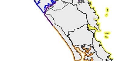
Acknowledgements
We wish to thank all those people who provided us with their time, hospitality and
friendship in the course of this project, particularly those people from the iwi in each
study region. This project was funded by the Foundation for Research, Science &
Technology.

                                         Disclaimer

Neither AquaBio Consultants Limited, nor any of its employees makes any warranty, express or
implied, or assumes any liability or responsibility for use of this document or its contents by any
other person or organisation.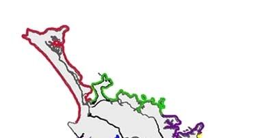
Table of Contents
                                                                       Page No.

1. Introduction                                                                 1

   1.1    How this book came to be written:                                       1
   1.2    What is this book about?                                                2
   1.3    How to find your way around this book:                                  3
   1.4    If you want more detailed information…                                  4

2. What are marine resources?                                                   4

3. Key features of marine ecosystems in Tai Tokerau                             4

   3.1    Introduction                                                          4
   3.2    Physical characteristics                                              5
               Wave exposure and coastal characteristics                        5
               Major currents                                                   7
               Coastal sediments                                                9
               Climate                                                         10
               Sea temperatures                                                10
               Salinity                                                        11
   3.3    Marine flora and fauna of Tai Tokerau                                12
   3.4    Features of the marine and coastal areas from Cape Brett to Takatu
          Point                                                                19

4. Potential Opportunities for Development of Marine
   Resources                                                                   21

   4.1    Introduction                                                         21
   4.2    Tourism                                                              21
   4.3    Aquaculture                                                          24
               Introduction                                                    24
               Mussel farming                                                  26
               Pacific oyster farming                                          28
               Other species                                                   31
   4.4    Fishing                                                              32
   4.5    Sand resources                                                       34
   4.6    Energy production                                                    36
   4.7    Discussion                                                           37
Table of Contents continued
Page No.
5. Conclusion 38
References 39
Glossary 431. Introduction
1.1 How this book came to be written:
The James Henare Mäori Research Centre (which is a research centre at the University of
Auckland that was established at the request of kaumatua from Tai Tokerau) gathered the
information for this book during a research project investigating “Sustainable Mäori Economic
Development in Tai Tokerau”. The research project has covered a different region each year.
Figure 1 shows a map of the regions studied.
Figure 1: Map showing the coastal regions studied in each year of the James Henare
Mäori Research Centre research project entitled “Potential for sustainable
Mäori economic development in Tai Tokerau”. Each colour represents one study
region. (Not shown is Aotea (Great Barrier Island) at the north of the
Coromandel Peninsula to the east).
For each area, the researchers looked at the terrestrial (that is, land-based), marine and coastal
resources, social and cultural resources, and business development issues. The research results
were reported back to iwi in each study area both at hui and in written reports. Because they are
so comprehensive, each report forms a book several inches thick. It has been evident from
discussion with iwi that there is a lot of interest in the marine resources of Tai Tokerau. We
therefore felt that it would be useful to re-format the results of our research on marine
1resources in each area into a series of smaller books that act as an introduction to the more
detailed reports. In this way, we hope that the information will be available to a wider range of
people.
1.2 What this book is about:
This book is about the marine resources in Tai Tokerau. It talks about what the marine
environment is like, what living things are found there, and the potential opportunities for these
things to contribute to sustainable Mäori economic development.
The marine resources we discuss in this book include those found on the coastal shoreline
(backshore), in the inter-tidal area (that is, the area between the high-tide mark and the low
tide mark on the shore), and in the sub-tidal area (that is, the area that is under the seawater all
the time) (See Figure 2).
Figure 2: Diagram illustrating the different tidal zones in the marine environment.
Because most people like to know about resources in their own local area, we have included
specific examples from only one of our study regions in this book. The area from which these
examples are taken is shown in Figure 3. The area includes the region from Cape Brett in the
north to Takatu Point in the south, and offshore islands, including the Poor Knights, Hen and
Chickens, Little Barrier (Hauturu), and Mokohinau Islands.
This book is written from a “Western-based science” perspective. Western science reveals just
one kind of knowledge about the marine environment. It complements other sources of
knowledge, such as traditional Mäori knowledge.
2Figure 3: Map showing the region from which examples in this book are taken. (Study
region is indicated by the coloured shading of the coast)
1.3 How to find your way around this book:
The sections following this introduction each look at different aspects of marine resources in Tai
Tokerau. We start with some definitions of resources in Section 2. Section 3 looks at what is
special about Tai Tokerau, including a brief outline of the physical environment, and the living
things that are found there. It also includes a very brief outline of some of the features of
marine resources in the region from Cape Brett to Takatu Point. Lastly, we present ideas about
how these marine resources could contribute to sustainable Mäori economic development in the
area (Section 4).
When we have presented a piece of information that comes directly from a scientific study that
has been published elsewhere, we provide information that allows you to find the original study by
giving the name of the scientist(s) that published the research, and the year the work was
published in brackets at the end of the sentence. (Note that when there are more than two
authors of the work, we follow the normal convention of referencing the study with the name of
the first author, followed by “et al.”, which simply means “and others”). At the end of this book
is a section called “References”, where the titles and publishing details of all these additional
studies are listed in alphabetical order by author. The librarian in your local library should be
able to get copies of any additional studies that interest you.
We have tried to explain the meaning of scientific words the first time they are used in the text
by highlighting the word in bold print and then providing the meaning in brackets straight
afterwards. We have also provided a list of definitions in the “Glossary” provided at the end of
the book.
31.4 If you want more detailed information…
In order to make this book an easily readable length, we have provided only a very brief overview
of each subject covered. You can find more detailed information about many areas in Tai Tokerau
by following the links to subjects that interest you on the James Henare Mäori Research Centre
web-site, starting at http://www.jhmrc.ac.nz., or at http://www.rakiora.maori.nz. As mentioned
above, the references provided in brackets throughout this book are also a source of more
detailed information.
2. What are marine resources?
Resources are assets used by people as a means of meeting some want or need, including (but not
only) economic income. They are a means to an end, valuable to the extent that they can be used
to create goods or services. For example, among other things fisheries resources provide
kaimoana and recreational opportunities (such as big-game fishing).
Society and culture defines what things are regarded as resources, and this may change over
time. For example, in 1800 the oil and gas fields off the coast of Taranaki were not thought of
as resources, but to New Zealanders today they are. Thus changing technology and needs
determine what are regarded as resources.
Marine resources are resources that are associated with the sea. For the purposes of our study,
we have considered resources in the sub-tidal, inter-tidal, and backshore zones of the marine
environment (refer back to Figure 2 for an illustration of where these zones are located).
3. Key Features of the Marine Ecosystems in Tai Tokerau
3.1 Introduction
Ecosystems are natural systems that include the organisms that live in a particular area,
together with the physical features of the environment in which they live (for example, ‘rocky
reef ecosystems’). This section talks about the types of ecosystems found in Tai Tokerau, and
the kinds of things that make them special compared to other areas in New Zealand. We start by
outlining the physical environment (e.g. the shape of the shore, waves, currents, climate etc.), and
then discuss the living things that are found there.
43.2 Physical Characteristics
Wave exposure and coastal characteristics
New Zealand is a group of islands with no other land close by to shelter our shores from exposure
to waves from the ocean. Most people in Tai Tokerau will have noticed that the waves on the
western coast are generally bigger than those on the eastern coast. This is because most of the
waves impacting on the New Zealand coast come from a south-westerly direction, and the
western coast of Tai Tokerau is exposed to waves from this direction. The western coast of Tai
Tokerau is therefore described as a moderate to high wave energy environment. In contrast, the
eastern coast of Tai Tokerau is a lee shore, sheltered from the prevailing waves from the south-
west by the land mass of Tai Tokerau. This coast is exposed to waves from predominantly
northerly and easterly directions. These waves consist of ocean swells caused by sub-tropical
storms, and waves generated by wind. The eastern coast can be described as a low to moderate
wave energy environment (Laing, 2000).
The roughness of the sea, as indicated by the height of the waves, varies with the season.
Maximum wave heights occur from May to August and minimum wave heights occur in December
and January (Laing, 2000).
As well as the broad difference in wave action between coasts, there are also differences in wave
exposure along the same coasts. These differences arise from the shape of the coastline, which
can provide localised shelter from waves. For example, the waters in the harbours of the
western coast of Tai Tokerau (such as the Kaipara and Hokianga Harbours) are more sheltered
than those on the exposed open coastline (such as Ninety Mile Beach). The map in Figure 4 shows
the shape of the coastline, and the major harbours of Tai Tokerau. You can see from this map
that except for the harbours, the western coastline is relatively straight, although it curves
gently to the north-west along Ninety Mile Beach. Between the Kaipara Harbour mouth and
Maunganui Bluff, and along Ninety Mile Beach, this open coastline is comprised of mostly sandy
beaches backed by sand dunes. Between Maunganui Bluff and Ahipara, there are sandy beaches
between rocky headlands and inter-tidal reefs.
You can also see from Figure 4 that the shape of the eastern coast is much more irregular than
that of the western coast. The eastern coast consists of sand or gravel beaches, interspersed
with rocky headlands and inter-tidal reefs. Islands are common inshore along this coastline, and
there are also lots of harbours and estuaries. On the eastern coast, the orientation of the
beaches (that is, the direction that the beach faces), and their fetch lengths, are highly variable.
(Fetch length is the distance that the wind can blow straight across water without being impeded
by land).
In addition to ecological differences between the western and eastern coasts arising from
physical differences, the general sea conditions and proximity of shelter make the eastern coast
more attractive for boating than the open western coast, particularly as the western harbours
tend to be protected by sand bars that can be hazardous.
5Figure 4: Map of Northland showing the outline of the coast, and the main harbours.
A generalised cross-section of the land and sea-bed in Figure 5 shows how the land mass of New
Zealand sits on the continental shelf. The sea-bed slopes relatively steeply off the edge of the
continental shelf down to the floor of the ocean basin, and this region is called the ‘continental
slope’.
Figure 5: Diagram of a generalised cross-section showing the slope of the sea floor off
the coast of Tai Tokerau.
6The continental shelf surrounding New Zealand varies in width from about five to 500 kilometres.
Figure 6 below shows the water depth of the sea surrounding Tai Tokerau. The extent of the
continental shelf is approximately indicated by the 250 metre depth line. On the eastern coast
the edge of the continental shelf is closer to the Tai Tokerau coast in the north (at North Cape
and Cape Brett) than in the south (at Bream Head and Takatu Point), while on the western coast
the width of the continental shelf does not vary as much from north to south.
Figure 6: Bathymetric chart of Northland. Note the extent of the continental shelf
which is bounded to seaward by the 250 m depth contour highlighted in red.
(Map adapted from Brodie, 1964).
Major Currents
There are two major ocean currents that influence the Tai Tokerau marine environment (see
Figure 7 below). Both originate from the Tasman Front, which is the major current that flows in
an easterly direction to the north of New Zealand (Carter et al., 1998). The West Auckland
Current flows down the western side of Tai Tokerau, and the East Auckland Current to the east.
7Figure 7: Map showing the major water currents associated with the marine environment
of Tai Tokerau (redrawn from Carter et al., 1998).
Different bodies of water (or water from different sources) may have different surface
temperatures. Satellite images can be used to measure the Sea Surface Temperature (SST for
short) around the coast of New Zealand. These images suggest that the West Auckland Current
flows along the edge of the continental shelf and that inshore of this there is a northward-
flowing current (Uddstrom and Oien, 1999). Sea surface temperatures suggest that the West
Auckland current appears to be strongest in autumn and winter but weak or absent in late spring
and summer (Uddstrom and Oien, 1999). However, the currents on the western coast of Tai
Tokerau have not been studied much compared to those in other areas in New Zealand, and
further research is required to fully understand water movement on this coast. (Some research
in this area is currently being undertaken by the National Institute of Water & Atmospheric
Research (NIWA)).
The East Auckland Current has a much larger flow than the West Auckland Current (Bury, 2001),
and its pattern of movement with respect to the edge of the continental shelf offshore from the
coast has significant implications for the ecology of eastern Tai Tokerau. The edge of the
continental shelf, which prevents the oceanic currents from coming onto the shelf itself,
generally prevents the mixing of water on the shelf with that of the East Auckland Current off
the edge of the shelf (Sharples et al., 1998). These two water masses thus tend to develop and
retain significantly different physical, chemical and biological characteristics. (For example, the
temperature of the water in the East Auckland current can be different from that of coastal
waters, and there are different species of plankton and fish present). However, under wind and
weather conditions that can occur in late spring and summer, a weak transfer of water across the
shelf edge may occur, with oceanic water moving onto the shelf, and coastal water moving into the
deep ocean. In regions where the continental shelf is narrow, such as on the north-eastern coast
of Tai Tokerau, this cross-shelf exchange of water has the potential to introduce oceanic species
(that is, organisms than normally live out in the deeper ocean rather than in waters close to the
coast) into nearshore coastal waters (Sharples, 1997; Sharples et al., 1998). People in Tai
8Tokerau talk about the coming of the “blue water” in summer. This is the annual intrusion of
water from the East Auckland current onto the continental shelf.
Coastal Sediments
The composition of the sediment on the coast and the bottom of the sea varies throughout Tai
Tokerau both with respect to the size of the particles in the sediment (e.g. coarse sand, fine
sand, silt etc.), and what the sediment particles are made of.
The size of the particles of sediment found on the shore tends to be related to the roughness of
the sea in the area. In sheltered areas where the water is generally very calm, the sediment
particle size is small. This is because when the water is calm, fine particles can settle out of the
water down to the bottom. In more turbulent (rough) waters, water movement keeps fine
particles suspended in the water, so the sediment on the bottom is comprised of the coarser
particles that are heavy enough to settle out. So for example, the sediment in sheltered
harbours and estuaries is much finer (e.g. silt or mud) than on beaches exposed to rough waves.
You may have noticed that beaches in different areas of Tai Tokerau have sands of a different
colour. This is because the composition of sand varies from place to place. Sand may contain
fragments of shell that have been broken up by wave action. It may also contain minerals (such
as iron in the black sands of Muriwai Beach on the western coast). Fragments of rock that arise
from the weathering of cliffs and headlands can also make up a very significant part of sand, so
the material that forms sand may reflect the local geology. However, in some cases, (such as in
the Hauraki Gulf) sand from some distance away may also be transported to the coast by rivers.
In addition, sediment such as mud or clay can be washed by rain from the land directly into the
sea, or into rivers or streams that carry it into the sea. As discussed above, this fine material
tends to settle out in areas where the water is calm, and thus forms a higher proportion of the
sediment in sheltered waters.
The sediment types on the open coast of Northland have been determined by sampling of marine
beaches and foredunes (i.e. sand dunes closest to the sea) and analysing their sand grain size,
mineral content, and the proportions of minerals present (Schofield, 1970). Open west coast
beaches of Tai Tokerau are composed of clean quartz-based sand. (Quartz is a mineral
comprised of silicon and oxygen, i.e. silicate). The sand is firmly compacted with little or no silt
or clay. (Because the coast is rough, these fine particles are kept in suspension in the water).
The quartz content of the sand averages about 56 % of the sediment (with the shell removed),
and has a low heavy mineral content of about 5 % compared with the black sand found to the very
south of the region (i.e. Muriwai Beach) (Applied Geology Associates, 1982). Erosion of the cliffs
on the western coast provides a continuing sediment source.
The eastern coast is a little more complex in that it has three different main sand types. From
Parengarenga Harbour to Doubtless Bay the sands are rich in silica (quartz). At the entrance to
Parengarenga Harbour the sand averages 95 % quartz, 5 % rock fragment and less than 1 % heavy
minerals (Applied Geology Associates, 1982). This sand is very white in colour. Further down the
east coast from Doubtless Bay to Ngunguru, the sediment has a higher rock fragment content (of
9greywacke rock), with approximately equal proportions of rock, quartz and feldspar sand and shell
fragments (Applied Geology Associates, 1982). (Feldspar is a group of minerals consisting of
silicates of aluminium). From Ocean Beach to Takatu Pt the sand is feldspar (55 to 76 %) with
quartz (19 to 33 %). Mafic minerals (silicate minerals relatively high in heavier elements e.g. iron)
and rock fragments constitute the remainder (Applied Geology Associates, 1982).
Climate
As mentioned above, vast oceans surround New Zealand. Because of this, all air masses that
reach New Zealand must travel for several days over water. This process evens out the air
temperature and explains why air temperatures at coastal locations do not vary greatly over the
different seasons (Fitzharris, 2001). The climate in the Tai Tokerau region is mild in comparison
to the rest of New Zealand, with a mean (that is, average) annual temperature of approximately
16 oC (National Climate Centre – Summary Statistics 1985-2000, Kaitaia and Whangarei data).
Monthly average air temperatures are typically in the range 19-20 oC in February (the annual
maximum) and 11-12 oC in July (the annual minimum) (Harris, 1985; Leigh Marine Laboratory, pers.
comm.). Virtually no frosts occur on the actual coast, or in the north of Tai Tokerau (e.g. Kaitaia).
However, some frosts do occur in the lower part of the region (e.g. Whangarei). Tai Tokerau has
relatively high mean sunshine hours (approximately 2020 hours per year, National Climate Centre
– Summary Statistics 1985-2000, Kaitaia and Whangarei data), and a moderate rainfall
(approximately 1412 mm per year) with the maximum rainfall occurring in winter. Tai Tokerau is
often promoted as the “Winterless North” because of its relatively warm climate.
Sea Temperatures
Seawater temperature is one of the most important physical properties of the marine
environment. The seawater temperatures off the Tai Tokerau coast are relatively warm when
compared to the rest of New Zealand. This is because warm subtropical water is forced down
both the eastern and western coasts of Northland (as described in the “Major Currents” section
above).
Average monthly mean sea surface temperatures recorded at the University of Auckland’s Marine
Laboratory at Goat Island, Leigh, indicate that minimum average coastal sea surface
temperatures occur in August (13.96 oC), and maximum average temperatures in February (20.56
o
C) (based on sea surface temperatures recorded from January 1967-December 2000) (see the
following Table 1).
10Month Average Monthly Mean Range
Temperature (oC) (oC)
January 19.91 17.60-21.95
February 20.56 18.03-22.88
March 20.41 18.82-21.63
April 19.12 17.20-20.61
May 17.32 15.96-18.50
June 15.58 14.69-16.96
July 14.37 13.46-15.64
August 13.96 13.03-15.05
September 14.33 13.04-15.33
October 15.27 13.99-16.54
November 16.69 15.30-18.04
December 18.30 16.85-20.03
Table 1: The average monthly mean sea surface temperature and monthly mean range in
sea surface temperature recorded at Auckland University’s Marine Laboratory,
Goat Island, from January 1967 to December 2000.
Sea temperature changes with distance from the coast. The sea on the continental shelf is often
cooler than that seaward of the shelf (Harris, 1985; Sharples et al., 1998). Data collated by
Harris (1985) for the eastern coast of Tai Tokerau from a number of sources indicate a general
trend of decreasing sea surface temperature from north to south. However in summer this trend
is reversed in the south of the area, as temperatures increase from the region between Great
Barrier Island and Bream Bay, towards the south into the Hauraki Gulf and the Firth of Thames.
The influence of the warm East Auckland Current off the eastern coast of Tai Tokerau results in
mean sea surface temperatures of approximately 1oC higher on the eastern coast than the
western coast at the same latitude (Sutton and Roemmich, 2001).
The comparatively mild climate and warm water temperatures not only influence the ecology of
the Tai Tokerau region, but also make Tai Tokerau an attractive place for marine-based
recreation.
Salinity
Salinity is a measure of the saltiness of the water. Salinity is commonly expressed as parts per
thousand (ppt. for short), and water in the open oceans away from the coasts around New Zealand
normally has a salinity of 34-36 ppt (Harris, 1985). There is a general trend of increasing salinity
with increasing distance from the coast. This is because freshwater run-off from the land
dilutes the sea near the coast. Salinity may also vary along the coast. Because estuaries are
areas where rivers or streams run into the sea, the salinity in these areas is lower than in the
open ocean. In contrast, areas of open coast distant from estuaries would be expected to have
11comparatively high salinity. (For a more detailed discussion of salinity variability in the region,
refer to Harris, 1985).
3.3 Marine Flora and Fauna of Tai Tokerau
This section talks about the marine flora and fauna (flora are plants, and fauna are animals) in Tai
Tokerau. Marine organisms tend to be adapted to live in specific conditions, with each organism
having its own physical requirements. From the previous discussion about the physical
environment you can see that there is a wide range of different marine environments in Tai
Tokerau – for example, exposed sandy beaches, sheltered sandy bays, sheltered and exposed
rocky shores, estuaries and harbours, and offshore islands. Each of these marine environments is
inhabited by groupings of plants and animals that are adapted to live there.
The composition of marine flora and fauna in Tai Tokerau reflects the broad environmental
differences of the region. On the western coast, which has lower sea surface temperatures than
the eastern coast, there is a dominance of species associated with cooler water. The eastern
coast is influenced by the warm East Auckland current, and the associated marine biota (biota
are living organisms) include significant numbers of warm temperate and sub-tropical species (i.e.
species that are adapted to living in warmer waters). Offshore islands in eastern Tai Tokerau
(such as the Poor Knights and Cavalli Islands) and prominent coastal headlands (e.g. Karikari
Peninsula and Cape Brett) lie in the path of sub-tropical water from the East Auckland Current
during summer. Algae (seaweed), corals, mollusca (e.g. shellfish), urchins and fish that are rare
or absent elsewhere around Northland and the rest of New Zealand are present in these areas.
This is one of the very special features of Tai Tokerau, and attracts divers and snorkellers to the
area.
Also associated with the seasonal influence of the East Auckland current is the occurrence of
larger fish species, such as marlin and swordfish, off the coast. These species provide the focus
of ‘big game fishing’ in the area. Other species that people often find interesting, such as sea
mammals, also occur on the eastern coast of Tai Tokerau. These include the regular presence of
dolphins in some areas (such as the Bay of Islands, and the coast near the Cavalli Islands), and
the seasonal migration of whales, which are frequently seen off the Tutukaka coast and near
Rangaunu Bay/Cape Karikari. Brydes whales and orca may be encountered all year round, and
minke, sei, pseudorca, pilot whales, humpback and southern rights whales from spring to early
summer.
12Figure 8: Bryde’s whale surfacing.
The more homogenous physical environment on the western coast (i.e. long exposed sandy shores
and reefs, plus harbour and estuarine environments) results in less diversity in ecosystems than is
present on the eastern coast of Tai Tokerau, which has open sandy beaches, enclosed sheltered
beaches, rocky shores and reefs, and estuaries and harbours. This diversity of marine
ecosystems close to many parts of Tai Tokerau (including areas such as the Aupouri Peninsula,
where both the western and eastern coasts are in very close proximity) is one of the special
features of Tai Tokerau.
Following is a very brief outline of some of the flora and fauna found in the different types of
physical environments present in Tai Tokerau.
Rocky shores:
Communities of plants and animals present on the rocky shore are found in a series of
horizontal bands (“zones”) depending on their ability to cope with the drying effects of
wind and sun at low tide. Different types of organisms are found in each zone. Figure 9
below provides a generalised illustration of the different communities of marine organisms
in each zone. Note that the actual species of organism may vary depending on how
exposed the rocks are to wave action (e.g. different types of seaweed, oysters, marine
snails etc). At the top of the shore, lichens and periwinkles are present. Below this, a
band of barnacles occurs and below this, native oysters (tio) (and in more sheltered places,
Pacific oysters) occur. Marine snails and limpets graze over the lower part of these zones.
Rocky inter-tidal areas with loose boulders or crevices also house many crabs. At the
bottom of the inter-tidal zone, a band of brown seaweeds occurs. In the shallow sub-tidal
zone, larger marine snails are found along with kina. Paua and sea cucumbers are also
found further down in the sub-tidal zone.
13Lichens
Periwinkles
Barnacles
Oysters
Chitons, Limpets, Top shells, Tube
worms, Corallina turf, Crabs
Brown and Red Seaweeds, Starfish
Sponges, Whelks, Urchins, Worms, Sea
cucumbers
Figure 9: Tidal zonation on a rocky shore, showing the generalised communities of
organisms present in each zone.
Fish near rocky reefs:
Fish tend to be abundant around rocky reefs below the inter-tidal zone because reefs
offer shelter and sources of food. On the eastern coast of Tai Tokerau, fish species
associated with reefs along the coast may change in abundance with latitude (i.e. from
north to south). Ward and Roberts (1986) studied the distribution and abundance of the
black angelfish and eight species of wrasse, at 10 coastal (mainland) and 8 offshore island
sites along the north-eastern coast of New Zealand. Wrasse are reef fish that feed
mostly on bottom-dwelling invertebrates. The study showed that the number of species
decreases as one goes further south, and that there was a cut-off on the coast, both in
the number of wrasse species, and in the presence of black angelfish, which occurs south
of Black Angel Bay (just north of Whananaki). They suggested that these differences
were related to the proximity of the East Auckland Current in the northern regions.
Similarly, in a study of the distribution patterns of planktivorous reef fish (i.e. reef fish
that eat plankton) along the coast of north-eastern New Zealand by Kingsford (1989),
contrasting patterns of abundance were found for 13 species along 100 kilometres of
coastline, from the Poor Knights Islands in the north to Kawau Island in the south.
Trends were apparent along the north-south axis in the study. Some species were more
abundant at the northern end (e.g. two-spot demoiselle and pink maomao) and others at the
southern end (e.g. horse mackerel). This probably relates to the geography and hydrology
of the area (for example, the influence of the East Auckland current) (Kingsford, 1989).
Open sandy beaches:
Due to wave action, water containing high levels of oxygen penetrates into the sediments
of open sandy beaches. The organisms that live on open sandy beaches tend to be quite
mobile, since they need to be able to avoid being buried under the sand as it is moved by
the waves. Crustaceans are the most common type of organisms found in the inter-tidal
14beach zone. They include sand hoppers and sea slaters in the upper shore, isopods in the
middle shore, and fast-burrowing amphipods, and shrimps on the lower shore. Burrowing
worms (polychaetes) are also common. Less plentiful but more easily found are bivalve
shellfish (bivalve means “two shells”). For example tuatua are often present in the lower
inter-tidal zone. Further out in the surf zone other types of bivalve shellfish exist, with
different species living in different water depths. These are commonly known as “surf
clams”. In deeper water off many of the beaches on the eastern coast, significant scallop
beds may exist.
Figure 10: Ruakaka Beach in Bream Bay, an example of an open sandy beach backed
by sand dunes.
Many of the sandy beaches in Tai Tokerau have sand dunes high on the beach. These may
be colonised by a variety of plants, including marram grass, spinifex, and the native pingao.
Pingao is an unusual and primitive plant found only in New Zealand. It has no close
relatives anywhere in the world. Pingao is regarded as a taonga by Mäori; it is used in fine
weaving and tukutuku panels, which are enhanced by the brilliant golden colour of the
dried leaf blades. Coastal dunes may also provide breeding places for birds such as the
New Zealand dotterel.
Estuaries:
Estuarine ecosystems occur where rivers or streams run into the sea. In general,
estuarine areas are more sheltered than the open coast, and this allows finer sediment to
settle out of the water (see earlier section on Sediments). Because the sediment
particles are small, the spaces between them are small also, and this restricts the
movement of water into the sediment. Because it is water movement that brings oxygen
into marine sediments, the fine sediments found in estuaries tend to become easily
depleted of oxygen. (This indirectly results in the black colour and “rotten egg” smell of
some layers of estuarine sediments). This, and the more sheltered conditions and lower
15salinity, means that the physical environment in estuaries is suited to a different range of
organisms than are present on the open coast.
Typically, mangroves and saltmarsh are found in estuarine areas. In New Zealand,
mangroves are confined to northern areas, being found only north of Tauranga. Amongst
the mangroves live a variety of organisms, including a range of gastropods (marine snails -
pupu), burrowing worms and crustacea (such as crabs). Oysters can also be found settling
on the trunks and pneumatophores (aerial roots) of mangroves in some areas. Fish species
in these habitats include mullet, parore, eels, flounder, and kahawai. Estuarine areas are
also attractive to coastal and wading birds.
Figure 11: Mangroves are common in estuarine areas in Tai Tokerau.
Landward of the mangrove swamps, the flats are only covered by the sea at spring tides.
Here the vegetation consists mainly of rushes and sedges. Beyond this lie saltmeadows,
where the margin of the land has been built up due to the continued trapping of silt, and is
rarely covered by tides. Here the flora consist of such species as glasswort and shore
pimpernels.
Estuarine areas are highly productive ecosystems. The value of mangrove forest is widely
ranging:
• They are a highly productive estuarine ecosystem of vital importance in animal food
webs. It has been estimated that mangroves produce up to 10 tonnes of organic plant
debris/hectare/year, and enrich the nearshore environment by a factor of at least 10
over similar coastlines lacking mangroves (Ritchie, 1976);
• They have a function in oxygenating the water and sediments of harbours;
• They provide important ecological links between marine ecosystems and terrestrial and
freshwater ecosystems;
16• They protect coastlines from erosion;
• They provide refuge for large numbers of bird species, including forest birds in the
canopy, and waders in the tidal flats;
Much coastal fishery in New Zealand is fundamentally dependent upon mangrove forests -
at least 30 species of fish use mangrove wetlands at some stage of their life cycle,
including commercially important species. It has been reported that of fish caught
commercially, 80% are linked to food chains dependent ultimately on mangroves.
Figure 12: Saltmarsh in the Ngunguru Estuary.
Harbours:
Many harbours in Tai Tokerau are formed from drowned river valleys, and thus contain
estuarine areas of mangroves and saltmarsh where the rivers enter the harbour. In
general, mangrove areas are increasing due to increasing siltation of harbours. Most
harbours also contain large areas of tidal flats that are important feeding grounds for
many species of wading birds, including species that migrate from other areas at some
times of the year. For example, some species migrate from the South Island in winter,
and others migrate all the way from the Arctic in summer. This means that any changes to
the harbour that impact negatively on the use of the harbour by wading birds not only
potentially affect birds that are permanently resident, but also birds that form part of
ecosystems many thousands of kilometres away. For this reason, many harbours in Tai
Tokerau are considered to have international ecological significance.
17Eel-grass can be a component of some harbour ecosystems – eel-grass beds have been
observed to come and go in harbours, and the reason for its changes in abundance is not
clearly understood. Some harbours contain shell-banks with plentiful cockles and pipi.
Species of fish that use mangroves as nursery and feeding grounds (including yellow-eyed
mullet, parore, kahawai, jack mackerel, juvenile anchovy, dab, yellow belly flounder, john
dory, snapper, and eagle ray) are common in harbours.
Figure 13: Inter-tidal sand-flats in harbours can provide important habitat for wading
birds.
Offshore Islands:
The offshore islands of Tai Tokerau have several features that make them ecologically
special. As previously mentioned, many of the offshore islands on the eastern coast lie in
the path of water from the East Auckland current in summer, and thus have a diversity of
fish species not found on the coast of the mainland. In addition, many of the offshore
islands were separated from the mainland millions of years ago, and this has led to the
evolution of species of plants and animals on the islands that are different from those on
the mainland. (Species of organisms that are found only in a particular region (in this case,
an offshore island) are known as endemic species). In addition, because of their
separation from the mainland, the flora and fauna (including coastal flora and fauna) of
offshore islands have in some cases been protected from predators and human
exploitation, and therefore still contain species that are rare or absent on the mainland.
In particular, these may include bird and reptile (e.g. lizards, geckos, tuatara) species.
In addition to the impact of natural physical features, the ecology of an area is influenced by the
impact of human activity. Much of the coastline of Tai Tokerau is inaccessible by road, and
therefore relatively unmodified by human activity. There are thus many areas of high natural
value within Tai Tokerau. Many of these areas, particularly areas of coastline, are protected by
regulation as reserves.
183.4 Features of the Marine and Coastal Areas from Cape Brett to
Takatu Point
By way of an illustration of the kinds of marine resources that may be present in Tai Tokerau, the
box below contains information about the features of the marine and coastal areas in the region
from Cape Brett in the north to Takatu Point in the south, and offshore islands, including the
Poor Knights, Hen and Chickens, Hauturu (Little Barrier), and Mokohinau Islands. If you want
more detailed information, this can be found on the James Henare Mäori Research Centre
website at http://www.jhmrc.ac.nz., or at http://www.rakiora.maori.nz. This information is also
available on CD from the James Henare Mäori Research Centre.
Box 1: Features of the Marine and Coastal Areas from Cape Brett to Takatu Point
High diversity of reef fish species, both on the main coast at Cape Brett and near offshore islands,
due to the influence of the East Auckland Current.
The presence of a range of migratory whale species (e.g. minke, sei, Pseudorca, pilot whales etc.),
especially in the north of the region.
Shellfish beds of significant size: Bream Bay is noted for its scallop beds, which are fished
commercially. Near the Whangarei Harbour mouth is Mair Bank, one of the largest known pipi beds
in New Zealand. Major cockle beds occur at Snake Bank (near the Whangarei Harbour mouth), and
in the Whangateau Harbour. (Mair and Snake Banks are commercially harvested). Commercial
scallop beds occur in Bream Bay and around Hauturu (Little Barrier).
Several marine reserves occur in the region, including the Poor Knights Islands, and Leigh Marine
Reserve.
Whangarei Harbour is Northland’s major port, and Tutukaka is a base for diving and big-game
fishing excursions. (The attractive opportunities for diving provided by the offshore islands (see
below) are enhanced by the sunken wrecks of the “Tui” and “Waikato” off the Tutukaka coast).
Leigh Harbour towards the south of the region is a fishing port, and there are many other
sheltered anchorages for boats travelling along the coast.
Outstanding mainland estuarine habitats, including (DoC, 1991):
o Whangaruru Harbour (particularly Punaruku Estuary, due to the presence of endangered or
rare bird species such as brown teal, fernbird, banded rail and kiwi)
o Helena Bay Swamp contains native orchids, and rare or endangered bird species, including
the largest known brown teal roost outside Great Barrier Island. Banded rail and bittern
also recorded.
o Whananaki, Matapouri Bay, Ngunguru/Horahora estuaries are also high value estuarine
environments due to the presence of rare or endangered birds.
o Pataua/Taiharuru estuaries, although modified by reclamation, also provide feeding and
nesting areas for a variety of coastal and wading birds, including some rare or endangered
species.
19Habitats of high value including (DoC, 1991):
o Ocean Beach - an exposed beach formed from a belt of semi-consolidated and consolidated
sand dunes behind a mobile foredune, with associated small wetland areas and a small
estuary at the northern end. The dominant vegetation includes pingao, marram and spinifex.
with coprosma, coastal herbs, and small areas of wetland plants. Endangered or rare fauna
at Ocean Beach include NZ dotterels, which are known to nest in the area, and variable
oystercatchers, which have been recorded as breeding there. Caspian terns and a wide
variety of other coastal and open country birds are also found.
o Whangarei Harbour is an outstanding habitat due to its birdlife. Over 82 species of birds
have been recorded in the harbour, which provides rich feeding grounds and isolated
roosting areas that are of international importance. Twenty-three species of birds have
been recorded as breeding in the harbour, including the rare NZ dotterel. The harbour
hosts many thousands of migratory birds from the Arctic in summer and from the South
Island in winter. The most important areas for birdlife are located on the south side of the
harbour, from Mangapai River through Takahiwai to Blacksmiths Creek and Marsden Point.
Rare or endangered species include NZ dotterel, banded rail, bittern, banded dotterel, red-
necked stint, wrybill, Far-eastern curlew, Asiatic whimbrel, Eastern little tern, sharp-tailed
sandpiper, curlew sandpiper, and fernbird.
o Ruakaka estuary is identified as an ecological area representative of a type that is becoming
increasingly difficult to preserve in its natural state,
o Waipu estuary provides a habitat for a number of rare and endangered bird species,
including NZ dotterel (known to nest in the area) red-necked stint, banded dotterel, wrybill,
long-billed curlew, Asiatic whimbrel, Caspian tern, Oriental dotterel, and Siberian tattler.
It is one of the few remaining areas where Fairy terns are known to nest.
o Mangawhai Harbour (the sandspit and adjacent island are classified as a habitat of national
significance with at least 27 bird species recorded. It is the only regular nesting area for
the Fairy tern in New Zealand and supports the second largest colony of nesting Caspian
terns in New Zealand. Other rare and endangered species include spotless crake, N.Z.
dotterel, fernbird, bittern, wrybill and the N.Z. pipit.
Offshore Islands: Rocky shores are the predominant marine habitat across all the offshore islands
in the region. Many ecosystems contain an abundance and variety of species not found on the
mainland coast. Most contain some tropical or subtropical species, presumably due to the influence
of the East Auckland Current. This makes many of the offshore islands attractive diving
destinations. Features of the offshore islands include:
o The Poor Knights Islands biota include many rare and endangered fish and mollusc species,
many breeding petrel species (including the only breeding area for Bullers shearwater),
endemic insects (e.g. Poor Knights weta) and unusual endemic plants.
o Hen and Chickens: rare forest bird populations, tuatura and ten species of lizard.
o Hauturu (Little Barrier Island) is the largest remaining native forest area in New Zealand
unmodified by browsing animals and man (Hauraki Gulf Maritime Park Board, 1983). As a
predator-free nature reserve, Hauturu plays an important role in the conservation of rare
and endangered bird species, which nest and breed on the island. It is a nature reserve of
international significance. Biota include several endangered bird species (e.g. kakapo), ten
reptile species, two bat species, and a species of giant weta found only there.
o Mokohinau Islands: A high diversity of encrusting organisms and fish (e.g. marlin, shark,
kingfish and hapuka), many bird species, reptiles (including an endangered skink), and rare
beetles.
204. Potential Opportunities for Development of Marine
Resources
4.1 Introduction
This section talks about ways in which marine resources in Tai Tokerau could contribute to
sustainable Mäori economic development. We also discuss some of the ecological issues relating
to the sustainable use of resources, such as the potential environmental impacts of using
resources in particular ways.
This discussion relates to marine resources in Tai Tokerau in general. For details about potential
opportunities for development of marine resources in specific areas, refer to the regional
reports that were provided to each iwi involved in the study (i.e. Jeffs. 1995; Forer et al., 1996;
Forer et al., 1997a; Forer et al., 1997b; Hay, 1998; Hay, 1999; Hay, 2000).
Based on the physical and ecological characteristics of the region, we present ideas about ways in
which marine resources could be developed. Whether or not they should be developed in these
ways involves consideration of a much wider set of issues, including the balancing of economic
issues (such as increased employment and income) with social and cultural values. We also note
that individual businesses would need to carefully consider the commercial feasibility of the
utilisation of these resources at a level of detail that is much greater than is discussed here.
There is a range of activities utilising marine resources that might be developed by Mäori for
economic benefit. The potential for these activities in Tai Tokerau, and issues related to the
sustainability of the resources on which they are based, are discussed in the following sections.
4.2 Tourism
Tourism is one of New Zealand’s largest export earners, contributing approximately 16 per cent
of the nation’s export earnings (Ward et al., 2002). Current visitor numbers of 1.8 million per
annum are projected to increase to 2.5 million in 2006 (Tourism Strategy Group, 2001). Tai
Tokerau is close to Auckland, which is one of the major ports through which tourists enter New
Zealand, and many tourists travel through at least part of the Tai Tokerau region (Page et al.,
1999). Auckland and Whangarei, which both have populations of significant size, are also a source
of domestic (i.e. Kiwi) tourists.
For tourism businesses, tourists represent the “tourism market”. Not all tourists have the same
budgets, expectations, or want to do the same things, so there are different tourism “market
sectors”. For example, some tourists like taking bus tours with lots of other people – they form
part of the “mass tourism sector”. Tourists that want to go bungy-jumping or white-water
rafting form part of the “adventure tourism sector”. Because different places in New Zealand
have different resources (both in terms of natural resources, and other resources such as
accommodation, shops etc.), they are attractive to different sectors of the tourism market.
21A large proportion of Tai Tokerau is not currently highly populated, and has retained significant
natural values – unpolluted water, isolated coastlines, and geology, flora and fauna of local and
international significance. The Tai Tokerau coastline is very scenic, comprising long sandy
beaches, picturesque coves, spectacular rocky shores, and attractive harbours. This makes it
ideal for the ‘NEAT’ tourism sector - Nature, Eco- and Adventure Tourism (Buckley, 2000), which
relies heavily on high quality environmental resources. This sector also includes tourism based on
special activities (for example, fishing). All these types of tourism are broadly referred to as
‘nature-based tourism’. Valentine (1992) defined nature-based tourism as tourism ‘primarily
concerned with the direct enjoyment of some relatively undisturbed phenomenon of nature’.
The natural resource requirements for nature-based tourism are determined by the
characteristics of the tourism type. Thus for example, the resource requirements for eco-
tourism may be different from the resource requirements for adventure tourism.
Eco-tourism is defined as ‘nature-based tourism that involves education and interpretation of the
natural environment, and is managed to be ecologically sustainable’ (Commonwealth Department of
Tourism, 1994). Eco-tourism includes the following principles – environmental sensitivity,
sustainability, educational experiences, and enhancing the natural environment. Eco-tourism is
the nature-based tourism type for which the type and quality of ecosystems is most important as
a necessary resource. Eco-tourism requires the ecology of an area to act as an attractant for
tourists. Features such as unusual, rare or endangered species or habitats, good examples of
unmodified ecosystem types, or conservation activities may be attractive to eco-tourists.
Figure 14: Watching dolphins, which are commonly present in some areas on the eastern
coast of Tai Tokerau, may form part of a tourism venture based on specialist
activities.
Adventure tourism may be defined as tourism that is ‘inclusive of an element of risk in the
experience, and requiring higher levels of physical exertion and the possible need for specialized
skills’ (Weaver, 2001). The natural resources necessary for adventure tourism vary with the type
22of tourism experience. For example, the natural resources required for a diving experience would
be different from those of a kayaking experience. Tourism based on specialist activities such as
fishing, or watching birds or sea mammals, require not only particular physical environments, but
also the predictable presence of inhabitants of the environment.
In addition to the NEAT tourism sector, coastal or marine resources of high scenic quality, such
as a series of magnificent views or unusual physical features, may provide the basis of tourism
based on sight-seeing. The ‘Hole-in-the-Rock’ at Piercy Island (Cape Brett) is one example of the
way in which a natural scenic resource in the marine environment of Tai Tokerau has been utilized
for the sight-seeing tourism sector.
Because it is potential for sustainable economic development with which we are concerned, issues
relating to the sustainability of tourism are relevant. Sustainable tourism has been defined as
‘tourism that does not threaten the economic, social, cultural or environmental integrity of the
tourist destination over the long term’ (Butler, 1993). Ecological sustainability in terms of
nature-based tourism involves the continued or prolonged use of natural resources without
degrading the resource. In the strictest sense, sustainable tourism includes not only having
sustained use of the natural feature that is the prime attractant, but also ecologically
sustainable practices in terms of water supply, waste disposal (e.g. ecologically sustainable
disposal of sewage and rubbish generated by tourists), greenhouse emissions etc. relating to that
tourism activity. This latter definition separates true ‘eco-tourism’ from other nature-based
tourism ventures.
It is apparent that there is a variety of marine resources in Tai Tokerau that could be utilised in
some way for tourism businesses. These include ecotourism ventures based on showing people
sites of outstanding significance (such as bird-watching in the harbours with a high diversity of
wading birds, visiting offshore islands with locally endemic species or rare reptile populations) or
taking advantage of the close proximity of a variety of different ecosystems to show visitors a
range of different marine habitats and organisms. The area is rich in sites of archaeological and
historical significance that could also be incorporated into such tours, and aspects of cultural
tourism, such as sharing the principles of kaitiakitanga, could also be included.
There are also many areas within Tai Tokerau, particularly on the eastern coast, where water-
based recreational activities can occur. Indeed, there is a seasonally high recreational use of
much of the coastline, as visitors from outside the area come to enjoy the swimming, surfing,
diving, boating, fishing, camping, picnicking, and walking opportunities that the area offers.
There is potential to turn some aspects of these activities into commercial ventures, where such
a venture could provide an experience that a visitor might not otherwise be able to access - for
example, by providing the visitor with the
• equipment,
• expertise,
• guides,
• local knowledge, or
• the companionship of doing something with a group of people.
23In some cases, the potential ecological impacts of tourism are restricted by regulation (for
example, the Department of Conservation regulations regarding interaction with sea mammals).
However, because there is still a lot to learn about the New Zealand environment, it is difficult to
anticipate visitor impacts on the environment before they happen. Potential impacts of tourism
on marine ecosystems may include
• pollution,
• physical disturbance (e.g. trampling),
• the introduction of new species,
• over-fishing (or sample collection),
• disturbance/noise, and
• unwanted interaction with wildlife (e.g. fish feeding etc).
A detailed discussion of visitor impacts on marine protected areas is provided in McCrone (2001).
‘Different activities, under various management regimes, cause different environmental impacts
in different ecosystems; and the ecological significance of these impacts differs greatly among
ecosystems’ (Buckley, 2001). It has been suggested that sustainable nature-based tourism should
involve deliberate steps to minimise impacts on the environment, through choice of:
• activity,
• equipment,
• location and timing,
• group size,
• education and training, and
• operational environmental management (e.g. management of waste, rubbish etc.
(Buckley, 2001).
Choosing a site for ecologically sustainable tourism involves matching a set of tourism activities
with an ecosystem that is robust enough to sustain the likely impacts of the activities without
becoming significantly modified over the long term. In some cases the ecology or physical
environment at a site may be too fragile to sustain any tourism activity at all. The development
of sustainable tourism thus involves not only consideration of the commercial, social and cultural
issues, but also careful consideration of tourism activities within the context of the ecosystems
in which they are to take place.
4.3 Aquaculture
Introduction
Aquaculture is the farming of aquatic species. Marine aquaculture may occur in the sea itself, or
in land-based facilities through which seawater is circulated. World-wide, aquaculture is the
fastest growing sector of food production (Jeffs, 2003). Global seafood production from wild
fisheries has remained relatively static since 1989, suggesting that production limits from
fisheries have been reached. However, the demand for seafood continues to increase, and is
predicted to increase beyond current production levels by a further 55 million tonnes by the year
24You can also read