2014 Mayflower Lake Management Plan - Marathon County
←
→
Page content transcription
If your browser does not render page correctly, please read the page content below
2014
Mayflower Lake Management Plan

      Prepared by staff from the Center for Watershed Science and Education
                      University of Wisconsin-Stevens Point.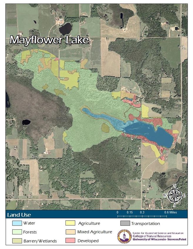
Lake Management Plan – Mayflower Lake 2
Mayflower Lake Management Plan

The Mayflower Lake Management plan was prepared after obtaining input from residents and lake users at a series of public planning
sessions held at the Norrie Town Hall in Birnamwood, Wisconsin on November 12 and December 10, 2013 and January 21 and February 11,
2014. The inclusive community sessions were designed to identify key community concerns, assets, opportunities, and priorities.
Representatives of state and local agencies, as well as nonprofit organizations also attended the planning sessions to offer their assistance
to the group in developing a strategic lake management plan (LMP).

The plan was adopted by the Town of Norrie on:             July 13, 2015______________________________
                                                           Date

The plan was adopted by Marathon County on                 August 18, 2015____________________________
                                                           Date

The plan was approved by the Wisconsin Department of Natural Resources on         _________________________________________
                                                                                  Date

Lake Management Plan – Mayflower Lake                                                                                                   3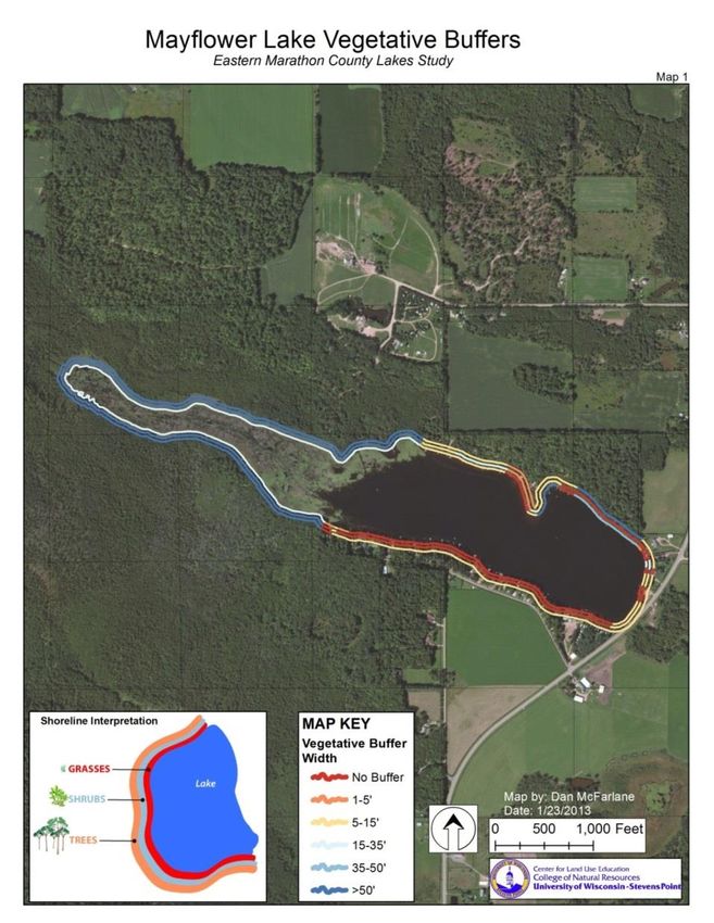
A special thanks to all who helped to create the Mayflower Lake Management Plan and provided guidance
                                           during the plan’s development.

               Marathon Lake Management Planning Committee Members and Resources
                     Planning Committee
                                                                                              Marathon County
          Matt Alwes                      Kolby Muscha                        Department of Conservation, Planning and Zoning
         Ken Bukowski                      Hank Ritter                               County Conservation Specialists –
        Charles Fischer                 Patricia Schwede                       Shawn Esser, Diane Hanson, Angela Wenninger
        Keith Frederick                  Joseph Suchon
        Cheryl Fredlund                  Delores Thayer                                    UW – Stevens Point
        Bill Greenwood                    Thomas Wahl                          Center for Watershed Science and Education
       Julie Greenwood                Town Board Members                  Water Resource Specialists – Ryan Haney and Danielle Rupp
         Kathi Meidam                      Alfred King                             Water Resource Scientist – Nancy Turyk
                                          Mike Melotik
                                                                                            UW – Extension Lakes
                                                                                              Director – Eric Olson

                                                                               Wisconsin Department of Natural Resources
                                                                                      Fisheries Biologist – Tom Meronek
We are grateful to many for providing insight, enthusiasm, and              Water Resources Management Specialist – Scott Provost
                                                                                    Lake Planning Specialist – Buzz Sorge
                          funding:

   Marathon County Concerned Citizens and Property Owners                                 Golden Sands RC&D, Inc.
Mayflower Lake District, Pike Lake Sportsman Club, and Wadley Lake   Regional Aquatic Invasive Species Education Specialist – Paul Skawinski
  Lake Management Plan –Sportsman
                           Mayflower Lake
                                      Club                                Regional Aquatic Invasive Species Specialist – Kaycie Stushek 4
             Marathon County Environmental Fund
Wisconsin Department of Natural Resources Lake Protection Grant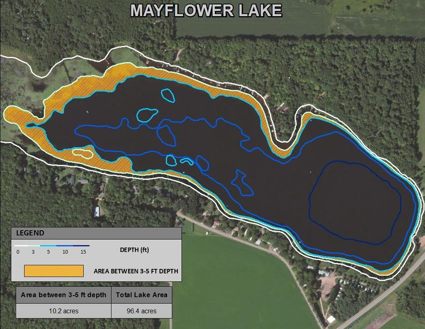
Lake Management Plan – Mayflower Lake 5
Contents
Introduction and Background .................................................................................................................................................................................................................. 8
Goals, Objectives and Actions ................................................................................................................................................................................................................ 11
   In-Lake Habitat and a Healthy Lake ................................................................................................................................................................................................... 13
       Aquatic Plants ................................................................................................................................................................................................................................ 13
       The Fish Community ...................................................................................................................................................................................................................... 17
       Critical Habitat ............................................................................................................................................................................................................................... 20
   Landscapes and the Lake ................................................................................................................................................................................................................... 23
       Water Quality ................................................................................................................................................................................................................................. 24
       Shorelands ..................................................................................................................................................................................................................................... 26
       Watershed Land Use ...................................................................................................................................................................................................................... 29
   People and the Lake ........................................................................................................................................................................................................................... 31
       Recreation ...................................................................................................................................................................................................................................... 32
       Communication/Organizations ...................................................................................................................................................................................................... 33
       Updates and Revisions ................................................................................................................................................................................................................... 34
       Governance .................................................................................................................................................................................................................................... 34
   References and Important Documentation to Review: ..................................................................................................................................................................... 41
Appendices ............................................................................................................................................................................................................................................. 42
   Appendix A: Marathon County Lake Information Directory ............................................................................................................................................................. 43
   Appendix B: Invasive Species Rapid Response Plan 2014 ................................................................................................................................................................. 48
   Appendix C: 2014 Mayflower Lake Aquatic Plant Management Plan .............................................................................................................................................. 51
   Appendix D: 2011 Mayflower Lake Shoreland Survey ...................................................................................................................................................................... 72
   Appendix E: Aerator Diagram............................................................................................................................................................................................................ 74

Lake Management Plan – Mayflower Lake                                                                                                                                                                                                          6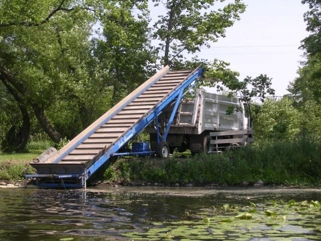
Overarching Vision for Mayflower Lake
Mayflower Lake will host a balanced aquatic plant community that benefits the health of the lake and
provides quality habitat, but does not impede lake users’ enjoyment of the lake or outdoor activities.
Clean, clear water will support abundant fish and wildlife. Beauty and peacefulness will be preserved
in the lake’s natural setting and promote quality of life spent with family and friends, resting and
relaxing. Residents and lake lovers will work together on behalf of the lake.
Mayflower Lake is located in quiet, rural southeastern Marathon County, Wisconsin. The lake is a central part of the community, providing residents and visitors
with opportunities to boat, swim, fish, relax, and find retreat at the two campgrounds that are situated on the lake. Although the residences and camping areas
make Mayflower Lake one of the more developed lakes in eastern Marathon County, natural beauty is equally present on the western, more undeveloped side
of the lake which boasts forests and wetlands. Mayflower Lake residents strongly value the wildlife that visits their lake, and the quality of the water it contains.
In 2013 and 2014, these values inspired the community members of Mayflower Lake to come together in partnership with local professionals to learn about
Mayflower Lake and to create a lake management plan to protect and improve their lake for generations to come.
Based on discussions throughout the planning process, Pike Lake planning session participants identified some key issues and goals that they would like to focus
on in upcoming years:
Reduce and maintain aquatic plant growth in Mayflower Lake
Improving shoreland habitat
Enhance the sport fishery in the lake
Lake Management Plan – Mayflower Lake 7
Introduction and Background
This lake management plan (LMP) and its planning process allow the community to guide the fate of its lake. The LMP is a dynamic document that identifies
goals and action items for the purpose of maintaining, protecting and/or creating desired conditions in a lake for within given period of time. It can correct past
problems, improve on current conditions, and provide guidance for future boards, lake users, and technical experts by identifying which issues have been
addressed and how successful previous efforts were. Each plan is unique, dependent upon the conditions of the lake, its watershed, and the interests of the
stakeholders involved. The actions identified in this LMP serve as a gateway for obtaining grant funding and other resources to help implement activities
outlined in the plan. Because many entities are involved in lake and land management, it can be challenging to navigate the roles, partnerships, and resources
that are available. The planning process and content of this plan have been designed to identify where some of the key assistance exists.
Many individuals and organizations are involved in assuring that the Mayflower Lake ecosystem is healthy. It is essential for key partners who are responsible for
lake and land management work together to achieve this goal. The planning process and content of this plan have been designed to identify where some of the
key assistance exists. Following is a list of key partners; this list is not all inclusive.
Individuals: Individuals can use this plan to learn about the lake they love and their connection to it. People living near Mayflower Lake can have the
greatest influence on the lake by understanding and choosing lake-friendly options to manage their land and the lake.
Mayflower Lake Protection and Rehabilitation District: This plan provides the District with a well thought out plan for the whole lake and lists options
that can easily be prioritized. Annual review of the plan will also help the District to realize its accomplishments. Resources and funding opportunities for
District management activities are made more available by placement of goals into the lake management plan, and the District can identify partners to
help achieve their goals for Mayflower Lake.
Neighboring lake groups: Neighboring groups with similar goals for lake stewardship can combine their efforts and provide each other support, improve
competitiveness for funding opportunities, and make efforts more fun.
The Town of Bevent: The Town can utilize the visions, wishes, and goals documented in this lake management plan when considering town-level
management planning or decisions within the watershed that may affect the lake.
Marathon County: County professionals will better know how to identify needs, provide support, base decisions, and allocate resources to assist in lake-
related efforts documented in this plan. This plan can also inform county board supervisors in decisions related to Marathon County lakes, streams,
wetlands, and groundwater.
Wisconsin Department of Natural Resources (WDNR): Professionals working with lakes in Marathon County can use this plan as guidance for
management activities and decisions related to the management of the resource, including the fishery, and invasive species. Lake management plans
help the WDNR identify and prioritize needs within Wisconsin’s lake community, and decide where to best apply resources and funding. A well thought
out lake management plan increases an application’s competitiveness for funding from the State – if multiple Marathon County lakes have similar goals
in their lake management plans, they can join together when seeking grant support to increase competitiveness for statewide resources. Information
about WDNR grants is located on their website http://dnr.wi.gov/lakes/grants/. Grant contacts are also listed in Appendix A.
Lake Management Plan – Mayflower Lake 8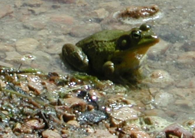
The Eastern Marathon County Lakes Project was initiated by citizens who encouraged Marathon County to work in partnership with UW-Stevens Point to assess
11 lakes located in the eastern portion of the county, with funding from the Wisconsin Department of Natural Resources (WDNR) Lake Protection Grant
Program, the county’s environmental fund, and monetary and in-kind contributions from citizens. One of the first steps of the project was the Eastern Marathon
County Lakes Study (2010-12), which gathered and compiled data about the 11 lakes and their ecosystems in order to understand past and current lake
conditions. Prior to this study, most of the lakes had limited data available to evaluate current water quality concerns, shoreland health, surrounding land use,
aquatic plant communities, invasive species, and the fishery. Professionals and students from UW-Stevens Point conducted the study and interpreted the data
for use in lake management planning. The results of this project (including this document) will assist citizens, municipalities, Marathon County, and State staff to
efficiently manage their water resources and help make informed decisions and policies that affect their lakes.

In addition to the Eastern Marathon County Lakes Study, data collected by citizens, consultants, and professionals from the WDNR were incorporated into the
planning process to provide a robust set of information from which informed decisions were made in this plan. Sources of information used in the planning
process are listed at the end of this document for future reference.

Several reports from the Mayflower Lake Study and the materials associated with the planning process and reports can be found on the Marathon County
website: http://www.co.marathon.wi.us/Departments/ConservationPlanningZoning/ConservationServices/LakePrograms.aspx.Mayflower

The purpose of this plan is to learn about Mayflower Lake and identify features important to the Big Bass Lake community in order to provide a framework for
the protection and improvement of the lake. This framework will enable the committee to achieve its vision for Mayflower Lake in the years to come. The
planning process included a series of four public planning sessions which were held at the Bevent Town Hall to assist area residents, Mayflower Lake
Management District members, lake users, and representatives of local municipalities with the development of the lake
management plan. Four meetings took place between November 2013 and February 2014. Participation in the planning
                                                                                                                                      The purpose of this plan
process was open to everyone and was encouraged by letters sent directly to Mayflower Lake waterfront property owners and
                                                                                                                                         is to learn about
by press releases in local newspapers.
                                                                                                                                           Mayflower Lake,
Guest experts and professionals were invited to attend the planning sessions. They presented information and participated in               identify factors
discussions with participants to provide context, insight and recommendations for the lake management plan, including                     important to lake
environmental and regulatory considerations. Information provided by the professionals was organized with the survey results          residents and users, and
into discussion topics, which included: the fishery and recreation; the aquatic plant community; water quality and land use;
                                                                                                                                      develop goals to protect
shoreland health; and communication. After learning about the current conditions of each topic, participants identified goals,
                                                                                                                                      and improve Mayflower
objectives, and actions for the lake management plan that were recorded by professionals from UW-Stevens Point. Planning
                                                                                                                                           Lake. for future
session notes and presentations were posted to the Marathon County website.
                                                                                                                                             generations.
The Mayflower Lake Planning Committee consisted of Mayflower Lake Management District and town board members.

Lake Management Plan – Mayflower Lake                                                                                                                        9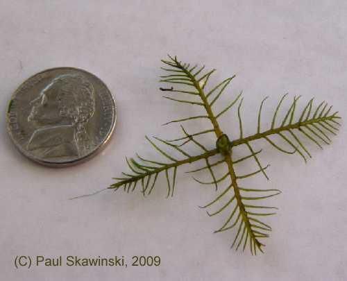
Technical assistance during the planning process was provided by professionals from the Marathon County Conservation Department, Wisconsin Department of
Natural Resources (WDNR), Golden Sands Resource Conservation and Development, Inc., UW Extension-Lakes, and the UW-Stevens Point Center for Watershed
Science and Education (CWSE).

Lake Management Plan – Mayflower Lake                                                                                                            10
Goals, Objectives and Actions
The following goals, objectives, and associated actions were derived from the values and concerns of citizens and members of the Mayflower Lake Management
Planning Committee, and the known science about Mayflower Lake, its ecosystem and the landscape within its watershed. Implementing and regularly updating
the goals and actions in the Mayflower Lake Management Plan will ensure that the vision is supported and that changes or new challenges are incorporated into
the plan. A management plan is a living document that changes over time to meet the current needs, challenges and desires of the lake and its community. The
goals, objectives and actions listed in this plan should be reviewed annually and updated with any necessary changes.

Although each lake is different, to ensure a lake management plan considers the many aspects associated with a lake, the Wisconsin Department of Natural
Resources requires that a comprehensive lake management plan address, at a minimum, a list of topics that affect the character of a lake, whether each topic
has been identified as a priority or as simply something to preserve. These topics comprise the chapters in this plan. For the purposes of this plan, the chapters
have been grouped as follows:

        In-Lake Habitat and a Healthy Lake
                Aquatic Plant Community—habitat, food, health, native species, and invasive species
                Fish Community—fish species, abundance, size, important habitat and other needs
                Critical Habitat—areas of special importance to the wildlife, fish, water quality, and aesthetics of the lake

        Landscapes and the Lake
               Water Quality and Quantity—water chemistry, clarity, contaminants, lake levels
               Shorelands—habitat, erosion, contaminant filtering, water quality, vegetation, access
               Watershed Land Use—land use, management practices, conservation programs

        People and the Lake
               Recreation—access, sharing the lake, informing lake users, rules
               Communication and Organization—maintaining connections for partnerships, implementation, community involvement
               Updates and Revisions—continuing the process
               Governance—protection of the lake, constitution, state, county, local municipalities, Lake District

Lake Management Plan – Mayflower Lake                                                                                                                       11
Lead persons and resources are given under each objective of this plan. These individuals and organizations are able to provide information, suggestions, or
services to accomplish objectives and achieve goals. The following table lists organization names and their common acronyms used in this plan. This list should
not be considered all-inclusive – assistance may also be provided by other entities, consultants, and organizations. Contact information for organizations and
individuals who support lake management in Marathon County can be found in Appendix A. This list should not be considered all-inclusive – assistance may also
be provided by other entities, consultants, and organizations.
Acronym Organization/Resource
CBCW Clean Boats Clean Waters
CLMN Citizen Lake Monitoring Network
CWSE UWSP Center for Watershed Science and Education
CPZ Marathon County Planning and Zoning (includes Land Conservation Department)
MC Marathon County
NCCT North Central Conservancy Trust
NRCS USDA Natural Resources Conservation Service
RC&D Golden Sands Resource Conservation and Development Council, Inc.
UWSP University of Wisconsin-Stevens Point
UWEX UW-Extension
WEAL UWSP Water and Environmental Analysis Lab
WDNR Wisconsin Department of Natural Resources
WDOT Wisconsin Department of Transportation
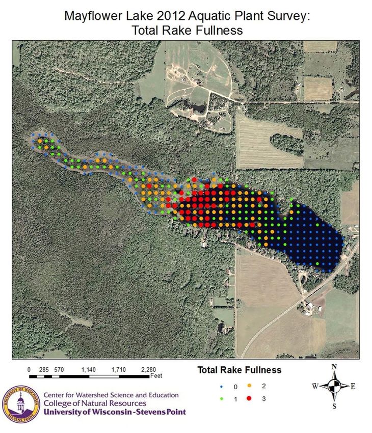
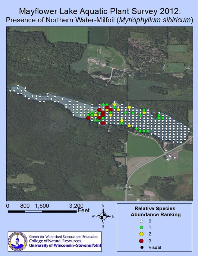
Lake Management Plan – Mayflower Lake 12In-Lake Habitat and a Healthy Lake Many lake users value Mayflower Lake for its fishing, wildlife, and good water quality. These attributes are all interrelated; the health of one part of the lake system affects the health of the rest of the plant and animal community, the experiences of the people seeking pleasure at the lake, and the quality and quantity of water in the lake. Habitat is the structure for a healthy fishery and wildlife community. It can provide shelter for some animals and food for others. Lake habitat occurs within the lake, along all of its shorelands, and even extends into its watershed for some species. Many animals that live in and near the lake are only successful if their needs – food, a healthy environment, and shelter – are met. Native vegetation including wetlands along the shoreline and adjacent to the lake provides habitat for safety, reproduction, and food, and can improve water quality and balance water quantity. Some lake visitors such as birds, frogs, and turtles use limbs from trees that are sticking out of the water for perches or to warm themselves in the sun. Aquatic plants infuse oxygen into the water and provide food and shelter for waterfowl, small mammals, and people. The types and abundance of plants and animals that comprise the lake community also vary based on the water quality, and the health and characteristics of the shoreland and watershed. Healthy habitat in Mayflower Lake includes the aquatic plants, branches, and tree limbs above and below the water. Aquatic Plants Aquatic plants provide the forested landscape Figure 1. Harvestable areas in Mayflower Lake between 3-5 feet. No harvesting in critical habitat areas or areas less than 3 feet of within Mayflower Lake. They provide food and water. Lake Management Plan – Mayflower Lake 13
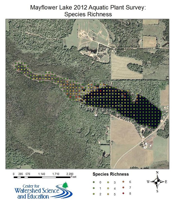
habitat for spawning, breeding, and survival for a wide range of inhabitants and lake visitors including fish, waterfowl, turtles, amphibians, as well as
invertebrates and other animals. They improve water quality by releasing oxygen into the water and utilizing nutrients that would otherwise be used by algae. A
healthy lake typically has a variety of aquatic plant species which creates diversity that makes the aquatic plant community more resilient and can help to
prevent the establishment of non-native aquatic species.

Aquatic plants near shore provide food, shelter and nesting material for shoreland mammals, shorebirds and waterfowl. It is not unusual for otters, beavers,
muskrats, weasels, and deer to be seen along a shoreline in their search for food, water, or nesting material. The aquatic plants that attract the animals to these
areas contribute to the beauty of the shoreland and lake.

Residents of Mayflower Lake have written to the WDNR as early as 1948 seeking advice on aquatic plant control. The Mayflower Lake District was originally
established to address periodic winter fish kills and problem aquatic plant growth following winter fish kills in 1972, 1974 and 1975. The District levied its first
tax in 1976, using these funds to finance a feasibility study. The study, conducted by Northern Lake Service of Crandon, Wisconsin, identified potential
alternatives for managing the fish kills and excessive plant growth. At the August annual meeting in 1980, the Lake District decided to install a permanent
aeration system which has eliminated winter fish kills since its installation. Aquatic plant harvesting began in 1984 with the purchase of a harvester (harvesting
is now done by a contractor).

23 species of aquatic plants were identified in Mayflower Lake or wet areas of the shore during the 2011 survey. This is average compared to other eastern
Marathon County lakes, but Mayflower Lake has by far the most species of floating vegetation.

The dominant plant species in the survey was white water lily, followed by Fries’ pondweed and muskgrass. The seeds of the white water lily provide food to
waterfowl. The broad, floating leaves of this aquatic species offer shade and shelter to fish. Fries’ pondweed is also an important food source for waterfowl and
provides protective cover for fish and invertebrates. Muskgrass is a favorite food source for a wide variety of waterfowl, and is especially important cover and
food for young trout, largemouth bass and smallmouth bass.

The native Northern water milfoil is abundant in Mayflower Lake, particularly in areas of less than 10 feet depth that is not already dominated by water lilies.
Like the other aquatic milfoils, it has feather-like leaves below water, and flowers and tiny leaves arranged on emergent stalks. Northern milfoil can often
resemble and be confused with Eurasian milfoil, sometimes to the point where chemical analysis is required to distinguish them. In general, however, northern
milfoil tends to be a more robust plant and has fewer and more widely spaced leaflets pairs than Eurasian milfoil. It is an important part of the lake’s aquatic
plant community providing cover for fish and invertebrates and supports insects and other small animals. The abundance of the plant has become a nuisance,
however, to certain recreational activities in Mayflower Lake. Harvesting certain areas (particularly the 3-5 foot depth) is a common approach to minimize
recreational conflicts. An aquatic plant management plan has been prepared to address this issue. Some of the actions outlined in the aquatic plant
management plan have been incorporated into the goals and actions listed below; however, for a more detailed description of the aquatic plant study and
aquatic plant management options, reference the Mayflower Lake Aquatic Plant Management Plan (UWSP 2014).

Lake Management Plan – Mayflower Lake                                                                                                                         14
Mayflower Lake had been historically identified by the Wisconsin DNR as having curly-leaf pondweed populations. A special survey of Mayflower Lake was
conducted in June 2012 to specifically inventory populations of this non-native species. However, during the survey, no curly-leaf pondweed was found in the
lake. During the survey, variable-leaf pondweed and clasping-leaf pondweed were found in Mayflower Lake. These native species closely resemble curly-leaf
pondweed. Mayflower Lake was also inventoried for non-native aquatic species during the full aquatic plant survey in August of 2012. Once again, no aquatic
invasive species were found.

Overall, the aquatic plant community in Mayflower Lake can be characterized as having good species diversity when compared with the other lakes in the
Eastern Marathon County Lakes Study. The habitat, food source, and water quality benefits of this diverse plant community should be the focal points in future
decision-making concerning lake management strategies.

                                              Guiding Vision for Aquatic Plants in Mayflower Lake

    Mayflower Lake will host a diverse, balanced native aquatic plant community that provides quality habitat while still
                                               allowing for recreational use.

Goal 1: Reach a balance between high quality, unimpeded recreation (swimming, boating) and a healthy, balanced aquatic
plant community
Objective 1.1: Mechanically harvest plants in designated “nuisance” areas while minimizing disturbance of native aquatic vegetation.

Actions                                                            Lead person/group            Resources                            Timeline
Follow outlined actions in aquatic plant management plan.          Lake District Commission     WDNR Water Resources
                                                                                                Management Specialist
Explore the purchase of a harvester (new/used) for Mayflower       Lake District Commission     WDNR Water Resources
Lake.                                                                                           Management Specialist
Contract to harvest in designated areas >3 feet in depth using     Lake District Commission     WDNR Water Resources                 1-3 times per
GPS (~$150/hour).                                                                               Management Specialist,               season
                                                                                                contractor
Ensure plants are removed from the lake by the performance of      Lake District Commission,    Contractor                           During harvesting
a second pass with the harvester to remove floating plants.        Contractor                                                        events
Avoid plant removal in and around bulrush beds.                    Lake District Commission,    Harvester/contractor,                Ongoing
                                                                   Contractor                   WDNR Fisheries Biologist

Lake Management Plan – Mayflower Lake                                                                                                                    15
Perform radial cuts or transects with harvester to maintain 18% Lake District Commission, WDNR Fisheries Biologist, 1-3 times per
open water for bluegill size structure improvement, with Contractor, WDNR harvester/contractor season
preference around docks. Fisheries Biologist
Maintain at least 20% of littoral zone (near-shore) vegetation for Lake District Commission, WDNR Fisheries Biologist, Ongoing
bass habitat. Contractor harvester/contractor
Objective 1.2: Use milfoil weevils (Euhrychiopsis lecontei) to help balance native aquatic plant bed density with recreational desires.
Actions Lead person/group Resources Timeline
Ask RC&D* to conduct a stem count for milfoil weevil presence. Lake District Commission, RC&D*
Contractor
Explore rearing milfoil weevils. Lake District Commission RC&D*
Goal 2: Prevent the establishment of aquatic invasive species through community awareness and sustainable management
of aquatic plants.
Objective 2.1: Be prepared to detect early invasion by monitoring, informing others, and protecting the existing ecosystem.
Actions Lead person/group Resources Timeline
Protect and leave in place as much native aquatic vegetation as Lake District Commission Ongoing
possible.
Reference Rapid Response Plan (located in the Appendix) when Lake District Commission RC&D*, WDNR Water Resources Ongoing
aquatic invasive species are found. Management Specialist
Include information about the threat of aquatic invasive species Lake District Commission UWEX Lakes Ongoing
in a welcome packet or newsletter and remind lake users to
clean plants off trailers, drain motors and live wells, and wash
boats before and after entering/leaving the lake.
Learn to monitor for invasive species. RC&D*, interested citizens RC&D* Ongoing
Consider enrolling in Clean Boats, Clean Waters program. Lake District Commission RC&D* Ongoing during
boating months
* Note: Services offered by RC&D are dependent on available funds through grants or lake groups.
Lake Management Plan – Mayflower Lake 16The Fish Community A balanced fish community has a mix of predator and prey species, each with different food, habitat, nesting substrate, and water quality needs in order to flourish. Activities in and around a lake that can affect a fishery may involve disturbances to the native aquatic plant community or substrate, excessive additions of nutrients or harmful chemicals, removal of woody habitat, shoreline alterations, and/or an imbalance in the fishery. Shoreland erosion can cause sediment to settle onto the substrate, causing the deterioration of spawning habitat. Habitat can be improved by allowing shoreland vegetation to grow, minimizing the removal of aquatic plants, providing fallen trees or limbs in suitable areas, and protecting wetlands and other areas of critical habitat. People are an important part of a sustainable fish community; their actions on the landscape and the numbers and sizes of fish taken out of the lake can influence the entire lake ecosystem. Putting appropriate fishing regulations in place and adhering to them can help to balance the fishery with healthy prey and predatory species, can be adjusted as the fish community changes, and can provide for excellent fishing. Managing a lake for a balanced fishery can result in fewer expenses to lake stewards and the public. While some efforts may be needed to provide a more suitable environment to meet the needs of the fish, they usually do not have to be repeated on a frequently reoccurring basis. Protecting existing habitat such as emergent, aquatic, and shoreland vegetation, and allowing trees that naturally fall into the lake to remain in the lake are free of cost. Alternatively, restoring habitat in and around a lake can have an up-front cost, but the effects will often continue for decades. Costs in time, travel, and other expenses are associated with routine efforts such as fish stocking and aeration. Ideally, a lake contains the habitat, water quality, and food necessary to support the fish communities that are present within the lake and provide fishing opportunities for people without a lot of supplemental effort and associated expenses to maintain these conditions. Mayflower Lake supports a warm water fish community. In the 2012 survey, 9 fish species were sampled and identified out of the 14 total species that have been recorded in surveys dating back to 1958. Although most species observed had previously been reported in Mayflower Lake, the black bullhead and the bluegill- Lake Management Plan – Mayflower Lake 17
pumpkinseed hybrid were newly documented.

A variety of management techniques were attempted historically on Mayflower Lake to maintain fisheries and minimize aquatic nuisance plants. In 1959 WDNR
noted good potential to manage populations of northern pike, largemouth bass, and bluegill. In 1957 and 1958 adult northern pike were stocked, and public
opinion noted an increase in catchable-size bluegill with the introduction of predator fish. Due to this success, recommendations for a complete renovation
program with chemical treatment were proposed; however, the proposal was declined. In 1972, basic management focused on populations of northern pike,
largemouth bass, and panfish. As a result of frequent winterkill events, a permanent aeration system was installed on Mayflower Lake in 1979. A 1989 fisheries
report indicated largemouth bass were abundant, yet growth was slow. Walleye recruitment was noted as variable across years leading up to the 1989 report.

Fish stocking records for Mayflower Lake date back to 1938 according to WDNR files. Stocking efforts have largely focused on walleye; however, largemouth
bass, yellow perch and smallmouth bass have also been stocked. In spite of stocking efforts, walleye reproduction was not observed in the 2012 survey.

Mayflower Lake was first listed as an impaired water on 4/1/98 for the atmospheric deposition of mercury identified in fish tissue.

                                           Guiding Vision for the Fish Community in Mayflower Lake

                    Mayflower Lake will have a balanced fish community, providing a quality fishing experience.

Goal 3: To have balanced, healthy fish communities supported by quality habitat and water quality conditions necessary
for survival.
Objective 3.1: Prevent winter fish kills by use of an aerator.

Actions                                                                   Lead person/group           Resources                       Timeline
Continue current aerator use as documented historically.                  Lake District               WDNR Water Resources            Ongoing
                                                                                                      Management Specialist
Monitor dissolved oxygen concentrations every 7-14 days during            Lake District Commission    WDNR Water Resources            Ongoing
winter months (weather dependent) and periodically throughout the                                     Management Specialist
year.
Maintain records of aerator use and maintenance.                          Lake District Commission                                    Ongoing

Lake Management Plan – Mayflower Lake                                                                                                                  18
Objective 3.2: Protect and enhance habitat to support a balanced, healthy fish community.
Actions Lead person/group Resources Timeline
Work with the WDNR to strategically place radial cuts or transects in Lake District Commission, WDNR Fisheries Biologist Annually
densely vegetated areas to maintain 18% open water for bluegill size WDNR Fisheries Biologist
structure improvement.
Maintain at least 20% of littoral zone (near-shore) vegetation for bass Lake District Commission, WDNR Fisheries Biologist Ongoing
habitat. private contractor
(harvesting)
Enhance/protect existing woody habitat (logs, stumps, sticks, etc.). Lake District Commission, WDNR Fisheries Biologist Ongoing
WDNR
Apply for permits from the WDNR to place tree drops and/or fish Lake District Commission, WDNR Fisheries Biologist 2014/2015, Ongoing
sticks on south end of lake. WDNR
Protect and restore emergent vegetation (bulrushes) in littoral (near- Lake District Commission WDNR Fisheries Biologist, Ongoing
shore) zone. CPZ
Explore enhancement of walleye spawning habitat on eastern end of Lake District Commission Walleyes for Tomorrow, Ongoing
lake by addition of fish sticks (WDNR permit needed), spawning reef, WDNR Fisheries Biologist
and/or bulrush enhancements.
Objective 3.3: Understand and support the existing fish community.
Actions Lead person/group Resources Timeline
Collaborate with WDNR to conduct more frequent fish surveys. Lake District Commission, WDNR Fisheries Biologist Ongoing, at least once
WDNR every 5 years
Request that the WDNR conduct a fall/spring survey to more Lake District Commission, WDNR Fisheries Biologist Spring/Fall 2014 or 2015
accurately measure walleye population. WDNR
Seek evaluation of largemouth bass fishery. Lake District Commission, WDNR Fisheries Biologist
WDNR
Coordinate walleye/fish stocking efforts with the WDNR to avoid Lake District Commission, WDNR Fisheries Biologist Starting Spring 2014,
overlap and improve records of stocking. WDNR Ongoing
Coordinate efforts with WDNR if stocking larger walleye. Currently Lake District Commission, WDNR Fisheries Biologist
stocking biannually (odd years). 10-15”=$4.25 each. WDNR
Review current regulations; determine if other options exist that Lake District Commission WDNR Fisheries Biologist Ongoing, annually review
might better suit the lake.
Lake Management Plan – Mayflower Lake 19Critical Habitat
Special areas of lake harbor habitat that is essential to the health of a lake and its inhabitants. In many lakes in Wisconsin, critical habitat areas are identified by
biologists and other lake professionals with the WDNR to protect features in a lake that are important to the overall health and integrity of the lake including
aquatic plants and animals. While every lake contains important natural features, not all lakes have official critical habitat designations. Designating areas of the
lake as critical habitat results in the ability to identify these areas on maps and share information about their importance to inform others about the locations
and significance of these areas that could be vulnerable to damage by certain activities. Having a critical habitat designation on a lake can help lake groups and
landowners plan waterfront projects in a way that will minimize impact to this important habitat, ultimately helping to ensure the long-term health of the lake.
Biologists with the Wisconsin Department of Natural Resources (WDNR) visited Mayflower Lake in October 2003 to identify special areas in the lake that were
“sensitive and fragile areas that support the wildlife and fish habitat, provide mechanisms that protect the water quality in the lake, harbor quality plant
communities and preserve the places of serenity and aesthetic beauty for the enjoyment of lake residents and visitors”. The report identifies two areas, CH1 and
CH2, considered “sensitive and fragile areas that support the wildlife and fish habitat, provide mechanisms that protect the water quality in the lake, harbor
quality plant communities and preserve the places of serenity and aesthetic beauty for the enjoyment of lake residents and visitors”. CH1 encompasses the
wetland complex on the western end of the lake, and CH2 highlights the area on the northern shore adjacent to the wetland that remains relatively
undeveloped. These sensitive areas (now referred to as Critical Habitat Designations) are outlined in Figure 2. In general, recommendations in the report include:
1. Maintain aquatic vegetation in undisturbed condition.
2. Protect the emergent vegetation.
3. Prohibit logging in shoreline cedars.
4. No alteration of littoral zone except for improvement of spawning habitat.
5. Minimize removal of any shoreline or aquatic vegetation.
6. Do not remove fallen trees along shoreline.
7. Restore shrub cover on the shore to control nutrient run-off.
8. Do not use fertilizers.
9. Do not permit rip-rap, bank grading, dredging, retaining walls, gravel beds or sand blankets.
Lake Management Plan – Mayflower Lake 20CHD 1 was designated as critical habitat for the near-shore terrestrial habitat, shoreline habitat, and shallow water habitat found in this area. This type of habitat is important for maintaining water quality, a diverse aquatic plant community, valuable fish and wildlife habitat and outstanding natural scenic beauty. CHD 2 has a unique deep-water marsh that also provides important shallow water habitat. Figure 2 Critical Habitat Designations (formerly Designated Sensitive Areas) on Mayflower Lake, Marathon County. WDNR 2003. Lake Management Plan – Mayflower Lake 21
Guiding Vision for Mayflower Lake’s Critical Habitat

                             Sensitive areas in and around Mayflower Lake will remain intact and protected.

Goal 4: Protect existing important habitat for fish and wildlife such as ducks, geese, loons, eagles, sand hill cranes, frogs,
turtles and deer. Ensure a healthy lake ecosystem is sustained by protecting critical habitat areas.
Objective 4.1: Support critical habitat designations (CHDs) designated by WDNR professionals.

Actions                                           Lead person/group          Resources                       Timeline
Provide information about CHDs and their          Lake District Commission   UWEX Lakes, WDNR                Ongoing
importance to the lake via welcome packets,
newsletter, etc.
Support protection of land surrounding the        Lake District Commission   NCCT
wetlands on the western end of the lake.                                     NRCS
                                                                             WDNR Lake Protection Grants
                                                                             Wisconsin Stewardship Program
Increase plants/bulrushes in critical habitat     Lake District Commission   CPZ                             Starting 2014
designation (II)                                                             WDNR

Lake Management Plan – Mayflower Lake                                                                                        22
Landscapes and the Lake Land use and land management practices within a lake’s watershed can affect both its water quantity and quality. While forests, grasslands, and wetlands allow a fair amount of precipitation to soak into the ground, resulting in more groundwater and good water quality, other types of land uses may result in increased runoff and less groundwater recharge, and may also be sources of pollutants that can impact the lake and its inhabitants. Areas of land with exposed soil can produce soil erosion. Soil entering the lake can make the water cloudy and cover fish spawning beds. Soil also contains nutrients that increase the growth of algae and aquatic plants. Development on the land may result in changes to natural drainage patterns and alterations to vegetation on the landscape, and may be a source of pollutants. Impervious (hard) surfaces such as roads, rooftops, and compacted soil prevent rainfall from soaking into the ground, which may result in more runoff that carries pollutants to the lake. Wastewater, animal waste, and fertilizers used on lawns, gardens and crops can contribute nutrients that enhance the growth of algae and aquatic plants in our lakes. Land management practices can be put into place that better mimic some of the natural processes, and reduction or elimination of nutrients added to the landscape will help prevent the nutrients from reaching the water. In general, the land nearest the lake has the greatest impact on the lake water quality and habitat. Shoreland vegetation is critical to a healthy lake ecosystem. It helps improve the quality of the runoff that is flowing across the landscape towards the lake. It also provides habitat for many aquatic and terrestrial animals including birds, frogs, turtles, and many small and large mammals. Healthy shoreland vegetation includes a mix of tall grasses/flowers, shrubs, and trees which extend at least 35 feet Figure 3 Mayflower Lake’s watershed and surrounding land use. landward from the water’s edge. Shorelands can also encompass Lake Management Plan – Mayflower Lake 23
adjacent wetlands, which serve the lake by filtering contaminants, providing shelter for fish and wildlife, and decreasing the hazard of shoreline erosion by
providing a shoreland barrier from waves and wind.

The water quality in Mayflower Lake is the result of many factors, including the underlying geology, the climate, and land management practices. Since we have
little control over the climate and cannot change the geology, changes to land management practices are the primary actions that can have positive impacts on
the lake’s water quality. The water quality in Mayflower Lake was assessed by measuring different characteristics including temperature, dissolved oxygen,
water clarity, water chemistry, and algae. All of these factors were taken into consideration when management planning decisions were made.

Water Quality
A variety of water chemistry measurements were used to characterize the water quality in Mayflower Lake. Water quality was assessed during the 2010-2012
lake study and involved a number of measures including temperature, dissolved oxygen, water chemistry, and nutrients (phosphorus and nitrogen). Nutrients
are important measures of water quality in lakes because they are used for growth by algae and aquatic plants. Each of these interrelated measures plays a part
in the lake’s overall water quality. In addition, water quality data collected in past years was also reviewed to determine trends in Mayflower Lake’s water
quality.

Dissolved oxygen is an important measure in Mayflower Lake because a majority of organisms in the water depend on oxygen to survive. Oxygen is dissolved
into the water from contact with air, which is increased by wind and wave action. Algae and aquatic plants also produce oxygen when sunlight enters the water,
but the decomposition of dead plants and algae reduces oxygen in the lake. Dissolved oxygen concentrations in Mayflower Lake ranged from plentiful to limited,
depending upon depth and time of year. Dissolved oxygen was mixed from the lake surface to the lake bottom during spring and fall during overturn events. In
winter of both years, at the deep hole, dissolved oxygen concentrations fell below levels needed to support many fish species. Following spring overturn,
dissolved oxygen concentrations varied with depth as biological processes in the lake consumed or generated oxygen. Algal blooms produced periodic spikes in
dissolved oxygen concentrations at depths typically between 2 and 8 feet.

In Mayflower Lake, water clarity ranged from 5 to 10 feet. When compared with historic data, the average water clarity measured during the study was slightly
better in April, August and October, similar in September, and poorer during the growing season months of June and July. Fluctuations throughout the summer
are normal, as algal populations and sedimentation (primary influences on water clarity) increase and decrease. The natural stained brown color of water in
Mayflower Lake also contributes to reduced water clarity.

Chloride, sodium and potassium concentrations are commonly used as indicators of how a lake is being impacted by human activity. The presence of these
compounds where they do not naturally occur indicates sources of water contaminants. Over the monitoring period, average sodium concentrations were
observed at natural levels for central Wisconsin lakes, and average concentrations of chloride and potassium were slightly elevated. Although these elements
are not detrimental to the aquatic ecosystem, they indicate that sources of contaminants such as road salt, fertilizer, animal waste and/or septic system effluent
may be entering the lake from either surface runoff or via groundwater.

Lake Management Plan – Mayflower Lake                                                                                                                       24
Phosphorus is an element that is essential in trace amounts to most living organisms, including aquatic plants and algae.
Sources of phosphorus can include naturally-occurring phosphorus in soils and wetlands, and groundwater. Common                 One pound of phosphorus
sources from human activities include soil erosion, animal waste, fertilizers, and septic systems. Although a variety of       entering a lake can result in
compounds are important to biological growth, phosphorus receives so much attention because it is commonly the
                                                                                                                                up to 500 pounds of algal
“limiting nutrient” in many Wisconsin lakes. Due to its relatively short supply compared to other substances necessary for
                                                                                                                                          growth!
growth, relatively small increases in phosphorus result in significant increases in aquatic plants and algae.
                                                                                                                                    (Vallentyne, 1974)
Total phosphorus concentrations in Mayflower Lake ranged from a high of 34 µg/L in June 2011 to a low of 10 µg/L in
August 2012, with median growing season concentrations of 22.5 µg/L and 18 µg/L in 2011 and 2012, respectively. This is below Wisconsin’s phosphorus
standard for shallow seepage lakes of 40 µg/L.

Managing nitrogen, phosphorus and soil erosion throughout the Mayflower Lake watershed is one of the keys to protecting the lake itself. Near shore activities
that may increase the input of phosphorus to the lake include applying fertilizer, removing native vegetation (trees, bushes and grasses), mowing vegetation,
and increasing the amount of exposed soil. Nitrogen inputs to Mayflower Lake can be controlled by using lake-friendly land management decisions, such as the
restoration of shoreland vegetation, elimination/reduction of fertilizers, proper management of animal waste and septic systems, and the use of water quality-
based management practices.

                                               Guiding Vision for Water Quality in Mayflower Lake

Mayflower Lake will have clear, clean water with minimal contamination and oxygen sufficient to support fish populations
                                                  through the winter.

Goal 5: Maintain and improve current water quality conditions in the lake.
Objective 5.1: Routinely record water quality to show trends over time and track measurable improvement or degradation.

Action                                                         Lead person/group                     Resources                       Timeline
Continue water clarity (Secchi depth) monitoring every 3       CLMN                                  CLMN Coordinator                Every 3 weeks during
weeks during summer months.                                    Lake District Commission                                              summer months
Continue ice off/ice on monitoring.                            CLMN                                  CLMN Coordinator                Annually
                                                               Lake District Commission

Lake Management Plan – Mayflower Lake                                                                                                                   25
Begin routine water quality sampling at least once per CLMN CLMN Coordinator Once/month May- month May-September (Total Phosphorus and Chlorophyll- Lake District Commission September a). Continue use of aerator during winter months (records CLMN Annually, ongoing attached). Maintain records of aerator use, maintenance, Lake District Commission etc. Monitor and record dissolved oxygen concentrations year- Lake District Commission, aerator WDNR Ongoing throughout round in multiple locations (once/week during long, hard operator UWSP the year; more winters or every 7 to 14 days during average winters). CLMN Coordinator frequently in winter Objective 5.2: Reduce phosphorus loading to Mayflower Lake to help reduce plant and algae growth and improve water clarity. The goal will be achieved when the summer median total phosphorus concentration (5 samples taken monthly during May-September) falls below 20 µg/L for at least 3 consecutive years. Action Lead person/group Resources Timeline Decrease/eliminate personal use of fertilizers around Lake District Commission Ongoing the lake and in the watershed. Inform residential landowners around the lake and in Lake District Commission UWEX Lakes Ongoing the watershed about the impact of phosphorus- containing fertilizers on the lake by means of newsletter, picnic/summer event, posting, etc. Continue routine maintenance and improvements of CPZ CPZ At least once every 3 septic systems around the lake. years, Ongoing Encourage the installation of rain barrels, rain Lake District Commission CPZ Ongoing gardens, and native shoreland vegetation to slow the CPZ movement of storm water, soil, and nutrients toward the lake. Shorelands Shoreland vegetation is critical to a healthy lake ecosystem. It provides habitat for many aquatic and terrestrial animals including birds, frogs, turtles, and small and large mammals. It also helps to improve the quality of the runoff that is flowing across the landscape towards the lake. Healthy shoreland vegetation includes a mix of unmowed grasses/flowers, shrubs, trees, and wetlands which extend at least 35 feet landward from the water’s edge Lake Management Plan – Mayflower Lake 26
Mayflower Lake has 2.8 miles of shoreline. The overall findings show that 3,872 linear feet (26%) of shoreline were classified as having an unmowed grass/forb
buffer depth extending less than 35 feet from the water’s edge (Appendix). Similar results exist for the shrubs layer. The tree layer was found to be abundant,
but 5,709 linear feet (38%) were classified as having a buffer depth of only 5-15 feet inland. Mayflower Lake’s shoreland vegetation has been significantly
altered, especially along the southern and eastern shorelines. Most of the taller grasses, forbs and shrubs have been removed from these portions of the lake,
leaving very little taller vegetation for stormwater infiltration, erosion protection, and wildlife habitat. The western shoreline vegetation remains primarily in a
natural state with adequate vegetative buffers. If more development occurs on Mayflower Lake, changes in the amount of healthy shoreland can easily occur.
Minimizing impacts to Mayflower Lake from future development should include planning to ensure that prospective developers have the right information to
make good decisions and that zoning is in place to achieve habitat, water quality and aesthetic goals. In the figure to the right, the shorelands were color-coded
to show their overall health based on natural and physical characteristics observed during the 2011 survey. Blue shorelands identify healthy areas with sufficient
vegetation and few human disturbances. Red, orange, or yellow shorelands indicate locations where the shoreland could benefit from restoration or plantings.
The map displaying the results of the 2011 survey of the Mayflower Lake shoreland is located in the Appendix.

                                                  Guiding Vision for Mayflower Lake’s Shorelands

    Mayflower Lake will have a healthy shoreland that protects water quality and complies with zoning ordinances and a
                                      community that understands the significance.

Goal 6: Restore and protect healthy shoreland habitat around Mayflower Lake.
Objective 6.1: Improve shoreland health in residential areas and near impervious surfaces.

Actions                                                           Lead person/group           Resources                                 Timeline
Restore the shoreland with native plants from local plant         Lake District               Local plant nurseries                     Ongoing
nurseries.                                                        Commission                  CPZ
                                                                                              Consultant
Explore funding options for shoreland restorations: WDNR          Lake District               CPZ
grant if there is enough interest? Raise enough awareness         Commission                  WDNR Lake Management Grant
and interest in a grant for a community restoration effort via
newsletter, annual picnic, etc.
Focus on the southeastern end of the lake for shoreland           Lake District               CPZ                                       2014
restorations, rain gardens, etc. because of proximity to          Commission
impervious highway. Consider a restoration demonstration          CPZ
site (near boat launch).
Invite a shoreland specialist to annual meeting to talk about     Lake District               CPZ                                       Annual picnic/meeting

Lake Management Plan – Mayflower Lake                                                                                                                       27
You can also read