Unit of Management 25-26: Shannon Estuary Upper & Lower - Flood History and Key Environmental Issues - Strategic Environmental Assessment ...
←
→
Page content transcription
If your browser does not render page correctly, please read the page content below
Unit of Management 25-26: Shannon Estuary
                 Upper & Lower
 - Flood History and Key Environmental Issues

Strategic Environmental Assessment - Scoping
Report [Consultation Draft] - Annex III
Document Control Sheet                                                                             BPP 04 F8
                                                                                                       Version 7 April 2011

Client:              Office of Public Works                  Project No: 3210300
Project:             Shannon CFRAM Study
Document Title:      Unit of Management 25-26: Shannon Estuary Upper & Lower
                     Flood History and Key Environmental Issues
Ref. No:             TD_ENVT_0317_V1_C_JAC_Env_Scoping_Annex III_UoM25-26_120919

                      Originated by          Checked by            Reviewed by              Approved by
                       NAME                  NAME                  NAME                     NAME
 ORIGINAL
                       Muriel Ennis          Kelly                 Kelly Kasperczyk         Peter Smyth
                                             Kasperczyk
                       Oonagh Duffy

 DATE                  INITIALS              INITIALS              INITIALS                 INITIALS

 July 2012             Document Status       Draft: Issue to OPW for Review

                       NAME                  NAME                  NAME                     NAME
 REVISION
                       Muriel Ennis          Oonagh Duffy          Denise Meade             Peter Smyth

 DATE                  INITIALS              INITIALS              INITIALS                 INITIALS

 August 2012           Document Status       Issue to OPW for Approval

 REVISION              NAME                  NAME                  NAME                     NAME

                       Oonagh Duffy          Denise Meade          Denise Meade             Peter Smyth

 DATE                  INITIALS              INITIALS              INITIALS                 INITIALS

 September
                       Document Status       Final Report for Consultation
 2012

Copyright
Copyright Office of Public Works. All rights reserved.

No part of this report may be copied or reproduced by any means without prior written permission from the Office
of Public Works. If you have received this report in error, please destroy all copies in your possession or control
and notify the Office of Public Works.

Legal Disclaimer
This report is subject to the limitations and warranties contained in the contract between the commissioning party
(Office of Public Works) and Jacobs Engineering Ireland Limited.
Contents

       1      Introduction                                                  1
       1.1    Background                                                    1
       1.2    Consultation                                                  2

       2      Unit of Management Characteristics and History of Flooding    3
       2.1    Unit of Management Characteristics                            3
       2.2    History of Flooding                                           8

       3      Key Environmental Issues in Unit of Management 25-26         21
       3.1    Introduction                                                 21
       3.2    Population and Human Health                                  22
       3.3    Geology, Soils and Land Use                                  30
       3.4    Water                                                        41
       3.5    Air and Climate                                              59
       3.6    Biodiversity, Flora and Fauna                                61
       3.7    Fisheries, Aquaculture and Angling                           73
       3.8    Landscape and Visual Amenity                                 78
       3.9    Material Assets (economic), Development and Infrastructure   81
       3.10   Tourism and Recreation                                       84
       3.11   Archaeology and Cultural Heritage                            87
       3.12   Conclusion                                                   93

       References                                                          94
Annex III - Shannon Estuary Upper & Lower Unit of Management (UoM 25-26)

  1         Introduction

            1.1    Background

            As part of the Strategic Environmental Assessment (SEA) process, the Office of
            Public Works (OPW) invites you to give your views on the development and
            implementation of a series of Flood Risk Management Plans (FRMPs) in the
            Shannon River Basin District (RBD).

            This Annex represents a key element of the SEA scoping process for the proposed
            FRMP for the Shannon Estuary Upper & Lower Unit of Management (UoM 25-
            26) by describing the existing and potential future characteristics of the Unit of
            Management, summarising the history of flooding associated with its river
            catchments, and identifying the key social and environmental issues relating to
            flooding and flood risk management specific to this Unit of Management. This Annex
            should be read in conjunction with the overarching Shannon River Basin District
            Environmental Scoping Report which documents all other elements relevant to this
            scoping process.

            Your comments on the information outlined in this Annex, coupled with those on the
            overarching Shannon RBD Environmental Scoping Report, will assist the scoping
            of, and the consultation about, the environmental impacts of the Shannon Estuary
            Upper & Lower Unit of Management (UoM 25-26) FRMP by initiating the strategic
            environmental assessment scoping stage.

            The preparation of the FRMP for Unit of Management 25-26 will consider the risk of
            flooding from the rivers, estuaries and coastal waters at various different spatial
            scales. The locations that are considered to be potentially at risk of flooding, and
            therefore been identified as Areas for Further Assessment (AFAs) or Individual Risk
            Receptors (IRRs), will be subject to more detailed consideration in the development
            of the FRMP for this Unit of Management given their history of flooding, or where
            such risk might arise through future development or other changes/pressures.

            Flood maps indicating where flood risk from river, or estuarine/coastal waters exists
            within AFAs or at IRRs, and along the watercourses connecting AFAs / IRRs will be
            produced for this Unit of Management.

                                                                                               1
Annex III - Shannon Estuary Upper & Lower Unit of Management (UoM 25-26)

            1.2    Consultation

            You have an important role to play in helping us identify all the key issues relating to
            flood risk management, and we are keen to hear what you think. Specific to Unit of
            Management 25-26 (Shannon Estuary Upper & Lower), we welcome your
            comments on the key environmental issues.

            It is important to note that the information in this Annex accounts for pre-scoping
            consultation already undertaken with key organisations, and the following sections
            present our current understanding of the Lower Shannon and Upper Shannon Unit
            of Management. The SEA baseline and framework will develop as the Study
            progresses, and will be further informed by views and knowledge of stakeholders
            and the wider public.

            You can send us your views by email or by post to the details below.

                       Email                  shannon.cframs@jacobs.com
                       Write to               Shannon CFRAM Study
                                              Jacobs Engineering Ireland Ltd
                                              Merrion House
                                              Merrion Road
                                              Dublin 4
                       Telephone              01 2028113
                       Website                www.shannoncframstudy.ie

                                                                                                  2
Annex III - Shannon Estuary Upper & Lower Unit of Management (UoM 25-26)

2 Unit of Management Characteristics and History of Flooding

            2.1    Unit of Management Characteristics

            The Shannon Estuary Upper & Lower Unit of Management (UoM 25-26) is shown in
            Figure 2.1. This Unit of Management encompasses areas of the following counties;
            Sligo, Leitrim, Roscommon, Longford, Cavan, Meath, North and South Tipperary,
            Offaly, Galway, Clare, Westmeath, Limerick and small areas of Mayo and Laois. A
            very small area of County Fermanagh contributes to groundwater flow in the
            headwaters of the River Shannon.

            The Unit of Management is defined by the catchment of the River Shannon to its
            tidal limit just upstream of Limerick City. The full extent of the AFA defined for
            Limerick City lies within three Units of Management and includes all of the
            developed land within the contiguous urban area of Limerick, and all lands zoned for
            development in or adjacent to Limerick City (including areas that may be outside of
            the Limerick City Council jurisdictional boundary). For the purpose of this Study, this
            AFA will be assessed as part of Unit of Management 25-26.

            The River Shannon reportedly rises in the Shannon Pot, a round pond on the slopes
            of Cuilcagh Mountain in Co Cavan, from which a small stream emerges. However,
            the true source of the river is probably in Co Fermanagh where a small stream
            disappears into a sink-hole. The whole upper part of Cuilcagh Mountain consists of
            a porous limestone and is full of sink-holes and risers. From the Shannon Pot, the
            river is joined by a number of tributaries, some of which are larger than the river
            itself, and emerges into the head of Lough Allen.

            From Lough Allen the Shannon flows south through a series of navigation locks to
            Lough Ree. It is joined on its way by major tributaries including the Boyle and Inny,
            but also by the Shannon-Erne Waterway.

            Lough Ree discharges at Athlone and continues south. Between Athlone and
            Portumna the Shannon is wide and passes through an area of extensive peat bogs
            which form part of the natural floodplain. In the areas of mechanised peat
            extraction, silt from the peat bogs has encroached into the upper portions of Lough
            Derg. The silt is conveyed through a series of drainage networks used to convey
            runoff from the peat bogs. Although historically these networks discharged directly
            into the Shannon, some effort has been made to regulate this discharge with the
            intention of reducing the volume of silt leaving the bogs and entering the river.

            Prior to entering Lough Derg, the Shannon is joined by the River Suck, which flows
            through the town of Ballinasloe, as well as the River Brosna, River Little Brosna and
            the Grand Canal. The area between Athlone, Ballinasloe and Lough Derg form the
            Shannon Callows. On the final reach between Lough Derg and the tidal limit at
            Limerick, the Shannon is joined by the Mulkear on the left bank.

                                                                                                 3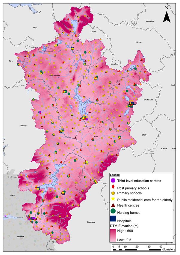
Annex III - Shannon Estuary Upper & Lower Unit of Management (UoM 25-26)

            Figure 2.1 - UoM 25-26 Shannon Estuary Upper & Lower Overview

                                                                            4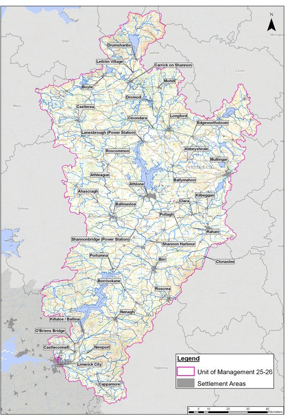
Annex III - Shannon Estuary Upper & Lower Unit of Management (UoM 25-26)

            Spatial Scales Assessment
            There are 10 Water Management Units (WMUs) within Unit of Management 25-26.
            These consist of the:

               •   Upper Shannon;
               •   Inny;
               •   Brosna;
               •   Little Brosna;
               •   Nenagh;
               •   Mulkear;
               •   Lough Derg;
               •   Hind/Lough Ree:
               •   Suck; and
               •   Camlin/Rinn.

            Table 2.1 and Figure 2.2 illustrate the AFAs and IRRs identified for Unit of
            Management 25-26, all of which may be subject to changes as the CFRAM Study
            develops.

                                                                                      5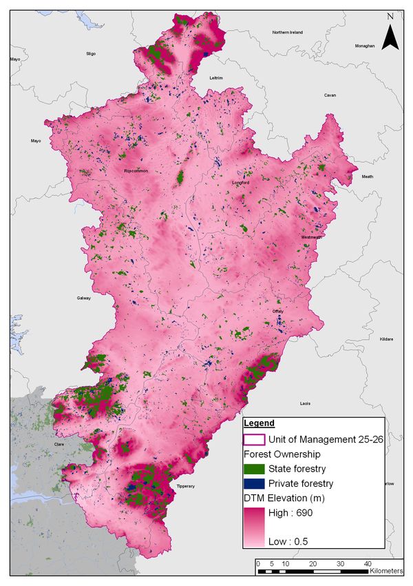
Annex III - Shannon Estuary Upper & Lower Unit of Management (UoM 25-26)

            Table 2.1: UoM 25-26 spatial scales of assessment
                      County                    WMU              AFA / IRR Name
            Areas For Further Assessment
                        Clare              Lough Derg                Springfield
                      Galway                    Suck                 Ballinasloe
                      Galway                    Suck                 Ahascragh
                      Galway               Lough Derg                 Portumna
                        Laois                  Brosna                 Clonaslee
                       Leitrim             Camlin/Rinn                  Mohill
                       Leitrim           Upper Shannon          Carrick on Shannon
                       Leitrim           Upper Shannon              Drumshanbo
                       Leitrim           Upper Shannon                 Dromod
                       Leitrim           Upper Shannon             Leitrim Village
                     Limerick                 Mulkear               Cappamore
                     Limerick              Lough Derg              Castleconnell
                     Limerick              Lough Derg             O'Briens Bridge
                   Limerick City              Maigue                Limerick City
                     Longford              Camlin/Rinn                Longford
                     Longford            Hind/Lough Ree               Cloondara
                     Longford                    Inny               Abbeyshrule
                     Longford                    Inny            Edgeworthstown
                     Longford                    Inny               Ballymahon
                       Offaly              Little Brosna                  Birr
                       Offaly                  Brosna                    Clara
                       Offaly                  Brosna                  Pollagh
                       Offaly                  Brosna                   Rahan
                       Offaly                  Brosna            Shannon Harbour
                    Roscommon            Hind/Lough Ree             Roscommon
                    Roscommon                   Suck                  Castlerea
                    Roscommon                   Suck                  Athleague
                    Roscommon            Upper Shannon                  Boyle
                     Tipperary                Mulkear                  Newport
                     Tipperary                Nenagh                Borrisokane
                     Tipperary                Nenagh                   Nenagh
                     Tipperary             Little Brosna               Roscrea
                     Tipperary             Lough Derg             Killaloe / Ballina
                    Westmeath            Hind/Lough Ree                Athlone
                    Westmeath                  Brosna                 Kilbeggan
                    Westmeath                  Brosna                 Mullingar
            Individual Risk Receptors
                     Longford            Hind/Lough Ree     Lanesbrough (Power Station)
                       Offaly              Lough Derg      Shannonbridge (Power Station)

                                                                                           6
Annex III - Shannon Estuary Upper & Lower Unit of Management (UoM 25-26)

            Figure 2.2 - UoM 25-26 Spatial Scales of Assessment

                                                                           7
Annex III - Shannon Estuary Upper & Lower Unit of Management (UoM 25-26)
2.2 History of Flooding
Within Unit of Management 25-26, there are records of significant flooding that has
occurred throughout the various WMUs from 1839 to 2009, affecting a number of
towns and villages. The major cause of flooding, based on the available records,
appears to be fluvial and tidal.
Tables 2.2 to 2.11 show the reported flood events for the AFAs and IRRs currently
identified within Unit of Management 25-25 WMUs. This historical flooding
information has been gathered using the OPW National Flood Hazard Mapping
website (www.floodmaps.ie), and the National Preliminary Flood Risk Assessment
(PFRA) Report (August 2011) produced by the OPW. The ‘known’ main flood
mechanism is not recorded for all flood events and is assumed for some records in
the tables below (these are shown in italics).
Table 2.2: Summary of historical flood events within the Upper Shannon
WMU
UPPER SHANNON WMU
Main Flood
Flood Event Description of Flood Event
Mechanism
(a) Boyle
1999/2000 Fluvial Railway flooded.
Oct 1998 Fluvial No flooding details available.
Railway line, railway station, Felton Road & Hanley
Jul 1996 Fluvial
Avenue flooded.
Dec 1992 Fluvial No flooding details available.
Recurring
Fluvial Entire Boyle town affected by flooding.
1970/1980s
Road and land flooding occurred a number of times
over the past few winters downstream of Boyle town. A
Recurring Fluvial
number of residential properties at Boyle at risk. Road
at Breandrum liable to flooding.
(b) Carrick on Shannon
Nov 2009 Fluvial 10 properties flooded (PFRA).
Major flooding to roads leading to & from Carrick on
Winter
Fluvial Shannon including N4 & N5. One residential property
1999/2000
reported flooded and businesses affected.
Winter
Fluvial Extensive flooding throughout the Shannon catchment.
1994/1995
Feb 1990 Fluvial Extensive flooding throughout the Shannon catchment.
Jan 1965 Fluvial No flooding details available.
Winter 1959 Fluvial Extensive flooding throughout the Shannon catchment.
4 families marooned. Carrick on Shannon completely
Dec 1954 Fluvial
isolated for communication. Roads and lands flooded.
Jan 1925 Fluvial Extensive flooding throughout the Shannon catchment.
The old N4 and road at Lough Eidin, Cleaheen &
Recurring Fluvial Sroankeeragh (R237) liable to flooding. Low lying land
at Sroankeeragh also flooded.
8Annex III - Shannon Estuary Upper & Lower Unit of Management (UoM 25-26)
UPPER SHANNON WMU
Main Flood
Flood Event Description of Flood Event
Mechanism
(c) Dromod
Nov 2009 Fluvial 3 properties flooded (PFRA).
Extensive flooding throughout the Shannon catchment.
Winter
Fluvial Residents of Lough Rynn Avenue were cut off from
1999/2000
communication and farmers’ lands were flooded.
Winter
1994/1995
Feb 1990
Fluvial Extensive flooding throughout the Shannon catchment.
Winter 1959
Dec 1954
Jan 1925
Land east of the N4 south of Dromod and west of the
Recurring Fluvial R202 in the Cloonturk area, significant area in Roosky
and road west of the R202 at Corrascoffy flooded.
(d) Drumshanbo
Winter
1999/2000
Winter
1994/1995 Fluvial Extensive flooding throughout the Shannon catchment.
Feb 1990
Winter 1959
Extensive flooding throughout the Shannon catchment.
Dec 1954 Fluvial Main roads flooded and train disrupted from
Ballinamore to Drumshanbo.
Jan 1925 Fluvial Extensive flooding throughout the Shannon catchment.
(e) Leitrim Village
Nov 2009 Fluvial 17 properties flooded (PFRA).
Winter
1999/2000
Winter
1994/1995
Feb 1990 Fluvial Extensive flooding throughout the Shannon catchment.
Winter 1959
Dec 1954
Jan 1925
9Annex III - Shannon Estuary Upper & Lower Unit of Management (UoM 25-26)
Table 2.3: Summary of historical flood events within the Camlin/Rinn WMU
CAMLIN/RINN WMU
Main Flood
Flood Event Description of Flood Event
Mechanism
(a) Mohill
Recurring Fluvial Lands and roads flooded in Clooncahir area.
(b) Longford
Railway line, lands & road flooded. Areas affected
Jan 2005 Fluvial including Mullagh, Great Water Street & Springlawn in
Longford.
Feb 2002 Fluvial No flooding details available.
Winter Area immediately to the south west of Longford
Fluvial
1999/2000 flooded.
Winter
Fluvial Extensive flooding throughout the Shannon catchment.
1994/1995
Feb 1990 Fluvial Extensive flooding throughout the Shannon catchment.
1987 Fluvial No flooding details available.
Sep 1968 Fluvial No flooding details available.
Jan 1965 Fluvial No flooding details available.
Winter 1959 Fluvial Extensive flooding throughout the Shannon catchment.
Dec 1954 Fluvial Extensive flooding throughout the Shannon catchment.
Mar 1947 Fluvial Reported one farmer’s house flooded.
Longford suffered incalculable damage. Wide area
Nov – Jan
Fluvial from Tarmonbarry to the entrance of Lough Ree was
1929/1930
under water.
Jan 1925 Fluvial Extensive flooding throughout the Shannon catchment.
N52 at Mullagh/Ballyminion, road & properties at
Springlawn, Little Water Street, Glack 2 and Whiterock
Recurring Fluvial affected. Road at Glack 1 and Driving Range also
liable to flood. Low lying area at Driving Range and
Whiterock floods every year after heavy rain.
Table 2.4: Summary of historical flood events within the Hind/Lough Ree
WMU
HIND/LOUGH REE WMU
Main Flood
Flood Event Description of Flood Event
Mechanism
(a) Athlone
Extensive flooding throughout the Shannon catchment.
Nov 2009 Fluvial
75 properties flooded on 19 Nov 2009 (PFRA).
Nov/Dec 2006 Fluvial No flooding details available.
Feb 2003 Fluvial No flooding details available.
60 to 80 residential properties flooded at Willow Park
Nov 2002 Fluvial Estate to a depth of 1200mm. Golden Island area
affected.
10Annex III - Shannon Estuary Upper & Lower Unit of Management (UoM 25-26)
HIND/LOUGH REE WMU
Main Flood
Flood Event Description of Flood Event
Mechanism
Burgess Park, McQuaids Bridge & Deer Park area
Feb 2002 Fluvial
affected by flooding.
Extensive flooding throughout the Shannon catchment.
Winter
Fluvial Barrymore, Golden Island, Creggan, Clonown,
1999/2000
Cloonbonny & Carrick O’Brien area flooded.
Winter Extensive flooding in the Shannon callow south of
Fluvial
1994/1995 Athlone. Clonown Road flooded.
Extensive flooding throughout the Shannon catchment.
Feb 1990 Fluvial 3,000 farm families & 700 acres of land south of
Athlone affected by flooding.
Hundreds of acres of land from Banagher to Athlone
Jan 1965 Fluvial
flooded.
Winter 1959 Fluvial Extensive flooding throughout the Shannon catchment.
Reported 124 farm holdings & 70 residential properties
between Athlone & Meelick seriously flooded.
Dec 1954 Fluvial
(Estimated 165 farms & 100 dwellings) Thousands of
acres of farmland flooded in the Shannon.
Nov – Jan
Fluvial Low lying areas of Athlone flooded.
1929/1930
Extensive flooding throughout the Shannon catchment.
Jan 1925 Fluvial
No flooding details available.
Low lying area at Railway Bridge, Ballymahon Road,
Retreat Rd, Railway Bridge, Coosan, Central Terrace,
Recurring Fluvial Cartron Drive, Auburn Heights & Marine View floods
after heavy rain every year. Considerable area North
of Athlone is flooded by the River Shannon.
(b) Cloondara
Winter Extensive flooding throughout the Shannon catchment.
Fluvial
1999/2000 Map showing Knappogue and Cloondara were flooded.
Winter
1994/1995
Feb 1990
Fluvial Extensive flooding throughout the Shannon catchment.
Winter 1959
Dec 1954
Jan 1925
Road at Cloondara and Knappogue is liable to flood
after heavy rain. River Fallan overflows its banks at
Recurring Fluvial
Fallan Bridge. Low lying areas floods after very heavy
rain at Cornollen.
(c) Roscommon
Extensive flooding in Roscommon including
Lanesborough Road (N63), north of Creevy Road, Golf
Links Road, access road at WWTP, Ballingard and
Athlone Road (N61). Flooding also occurred at the rear
Nov 2009 Fluvial
of Centrepoint Retail Park at Circular Road, Glenview,
Ballymartin. Derrydonnell and north of railway at
Bogganfin. Low lying area flooded at Ballinagard. 10
properties flooded in Roscommon (PFRA).
11Annex III - Shannon Estuary Upper & Lower Unit of Management (UoM 25-26)
HIND/LOUGH REE WMU
Main Flood
Flood Event Description of Flood Event
Mechanism
Minor flooding in and around Roscommon town. Low
Jan 1969 Fluvial lying land in the direction of Athleague severely
flooded.
Jan 1965 Fluvial No flooding details available.
Low lying land at the lough, Cloonyourish and Lisamult
floods every year. Low lying marsh land of the golf
Recurring Fluvial course near N61, Fearagh and Portrunny Bay
frequently flooded. N61, a country road and N63 also
flooded.
(d) Lanesborough Power Station (IRR)
Nov 2009 Fluvial Extensive flooding throughout the Shannon catchment.
Feb 2007 Fluvial The Turlough & access road to a house flooded.
Winter
Fluvial Extensive flooding throughout the Shannon catchment.
1999/2000
Winter Extensive flooding throughout the Shannon catchment
Fluvial
1994/1995 and Lanesborough.
Feb 1990
Winter 1959
Fluvial Extensive flooding throughout the Shannon catchment.
Dec 1954
Jan 1925
Table 2.5: Summary of historical flood events within the Suck WMU
SUCK WMU
Main Flood
Flood Event Description of Flood Event
Mechanism
(a) Ahascragh
Nov 2009 Fluvial One commercial property and adjoining lands flooded.
Low lying area around dip in the road floods after
Recurring Pluvial heavy rain every year due to inadequate road
drainage.
(b) Athleague
Fluvial &
Nov 2009 27 properties affected and roads in Athleague closed.
pluvial
Aerial photographs show extensive flooding in
Carderryhugh, Aghagower, Gorteenclough,
Jan 2005 Fluvial
Aghadabeg, Castlestrange to Athleague, Muff to
Carderryhugh, Carderryhugh to Rockwood.
Extensive area in Athleague and Coollusty flooded.
Surrounding land also flooded from Castlestrange to
Athleague. In Clooneen, low lying area flooded and
Recurring Fluvial road was liable to flooding.
(c) Ballinasloe
Nov 2009 Fluvial Residential and commercial properties affected by
12Annex III - Shannon Estuary Upper & Lower Unit of Management (UoM 25-26)
SUCK WMU
Main Flood
Flood Event Description of Flood Event
Mechanism
flooding in the Marina, Willow Park area, Derrymullan
and Ballinasloe town. More than 90 properties flooded
(PFRA).
Flooding affected Bellagill Bridge to concrete work,
Jan 2005 Fluvial Suck Bunowen area, Creggaun, Derrymullan & Rail
Bridge Ballinasloe area.
Residential & commercial properties affected by
Jan 1995 Fluvial flooding. Killure & Derrymullen Roads to Ahascragh &
Ballinasloe/New Inn Road were impassable.
Feb 1990 Fluvial Housing estate was flooded.
Flood water from the River Suck crept up on the
Jan 1965 Fluvial
grounds of a church at Ballinasloe.
Extensive flooding throughout the Shannon catchment.
Dec 1954 Fluvial
No flooding details available for Ballinasloe.
(d) Castlerea
Approximately 30 acres of land flooded. No properties
Recurring Fluvial
or roads flooded.
Table 2.6: Summary of historical flood events within the Lough Derg WMU
LOUGH DERG WMU
Main Flood
Flood Event Description of Flood Event
Mechanism
(a) Castleconnell
Castleconnell, Montpelier & Castletroy severely
affected. Roads from Charco’s to Scanlan Park & from
Nov 2009 Fluvial car parks towards the village flooded & damaged.
Households affected by flooding (9 families
evacuated). Farmlands flooded.
Dec 2006 Fluvial No flooding details available.
Many villages & roadways in Limerick county badly
Feb 1990 Fluvial
flooded.
Winter
1999/2000
Winter
1994/1995 Fluvial Extensive flooding throughout the Shannon catchment.
Winter 1959
Dec 1954
Aug 1946 Fluvial No flooding details available.
Jan 1925 Fluvial Extensive flooding throughout the Shannon catchment.
(b) Killaloe
2004 Fluvial Summerhill Road (R404) flooded.
Winter
1999/2000
Fluvial Extensive flooding throughout the Shannon catchment.
Winter
1994/1995
13Annex III - Shannon Estuary Upper & Lower Unit of Management (UoM 25-26)
LOUGH DERG WMU
Main Flood
Flood Event Description of Flood Event
Mechanism
Feb 1990
Winter 1959
Dec 1954
Foley’s Cross on the Killaloe-Scariff Road, the Birdhill
Aug 1946 Fluvial
Rly Bridge & road at Ballyvally severely flooded.
Jan 1925 Fluvial Extensive flooding throughout the Shannon catchment.
(c) Limerick City
Nov 2009 Fluvial Extensive flooding in the Limerick City area.
Dec 2006 Fluvial No flooding details available.
12 properties at Clancy’s Strand and roads flooded.
Jan/Feb 2002 Fluvial Other areas including O’Callaghan Strand, Corbally
Road etc also affected.
Flooding to the rear of properties 13-25 Athlunkard
Feb 2001 Fluvial
Street.
Winter Extensive flooding with up to 60 houses, roads & 200
Fluvial
1999/2000 acres of land flooded.
Corrib Drive, garages & an indoor play area to a
Oct 1995 Fluvial
Supermacs fast food outlet flooded.
Sir Harry’s Mall, Clancy’s Strand, Dock Road,
Longpavement, Rosbrien etc flooded. Roads, roadway,
Jan/ Feb 1995 Fluvial
low lying ground & at least 2 houses in the vicinity of
De Courcy’s Bridge flooded.
Roads shown as flooded from the photographs. No
May 1994 Fluvial
flooding details available.
Arthur’s Quay, Bishops Quay, Clancy’s Strand, Sarfield
Feb 1990 Fluvial House & car park, Condell Road & road from Corbally
to Crusheen flooded.
Aug 1986 Fluvial Limerick Road flooded.
Extensive flooding throughout the Shannon catchment.
Dec 1954 Fluvial
No flooding details available for Limerick City.
Rosbrien Road frequently flooded & 100 acres of
callow land between Rosbrien Road & Ballinacurra
Bridge flooded some months each year. Flooding of
roads, industries and open ground in the vicinity of the
Recurring Fluvial
Tipperary Roundabout & Ballysimon Road in the past.
Flooding to back gardens of houses in Ashbrook
Gardens. Considerable flooding at South Circular
Road area.
12 properties at Clancy’s Strand and roads flooded.
Jan/Feb 2002 Tidal Other areas including O’Callaghan Strand, Corbally
Road etc also affected.
Oct 2001 Fluvial No flooding details available.
Dec 2000 Tidal Severe flooding on R464 Longpavement.
Feb 2000 Fluvial No flooding details available.
Winter Extensive flooding with up to 60 houses, roads & 200
Tidal
1999/2000 acres of land flooded.
Feb 1997 Tidal >75 properties (>30 at Sir Harry’s Mall, >25 at Clancy
14Annex III - Shannon Estuary Upper & Lower Unit of Management (UoM 25-26)
LOUGH DERG WMU
Main Flood
Flood Event Description of Flood Event
Mechanism
Strand, ~20 at O’Callaghan), extensive areas of lands
& roads flooded.
Sir Harry’s Mall, Clancy’s Strand, Dock Road,
Longpavement, Rosbrien flooded. Roads, roadway,
Jan/Feb 1995 Tidal
low lying ground & at least 2 houses in the vicinity of
De Courcy’s Bridge flooded.
Roads shown as flooded from the photographs. No
Jan 1994 Fluvial flooding details available. Flood water pumped back
into the river.
Oct 1961 Tidal No flooding details available.
(d) O’Briensbridge
Extensive flooding in the O’Briensbridge area including
Montpelier. R525 Castleconnell to Mountpelier/
Nov 2009 Fluvial
O’Briensbridge closed due to flooding. Households
affected by flooding. Farmlands flooded.
Dec 2006 Fluvial No flooding details available.
Winter
Fluvial Extensive flooding throughout the Shannon catchment.
1999/2000
Winter 1994/95 Fluvial Extensive flooding throughout the Shannon catchment.
Many villages & roadways in Limerick county badly
Feb 1990 Fluvial
flooded.
Winter 1959 Fluvial Extensive flooding throughout the Shannon catchment.
Dec 1954 Fluvial Extensive flooding throughout the Shannon catchment.
Jan 1925 Fluvial Extensive flooding throughout the Shannon catchment.
(e) Portumna
Nov 2009 Fluvial Extensive flooding throughout the Shannon catchment.
Dec 2006 Fluvial No flooding details available.
Winter
Fluvial Extensive flooding throughout the Shannon catchment.
1999/2000
Up to half a dozen of houses badly damaged.
Thousands of acres of farmer flooded and houses
Feb 1995 Fluvial evacuated in a number of areas in the county.
Numerous roads impassable, particularly secondary
roads.
Winter
1994/1995
Feb 1990
Fluvial Extensive flooding throughout the Shannon catchment.
Winter 1959
Dec 1954
Jan 1925
(f) Shannonbridge Power Station (IRR)
Nov 2009 Fluvial Extensive flooding throughout the Shannon catchment.
Aug 2008 Fluvial Flooding occurred in several parts of the county.
Dec 2006 Fluvial No flooding details available.
Jan 2005 Fluvial Extensive flooding in the vicinity of Shannonbridge.
15Annex III - Shannon Estuary Upper & Lower Unit of Management (UoM 25-26)
LOUGH DERG WMU
Main Flood
Flood Event Description of Flood Event
Mechanism
Low lying area close to the Shannon floodplain flooded
2003 Fluvial
due to blocked drains.
Winter Extensive flooding throughout the Shannon catchment.
Fluvial
1999/2000 Farmers at Shannonbridge badly affected.
Winter
Fluvial Extensive flooding throughout the Shannon catchment.
1994/1995
Feb 1990 Fluvial Extensive flooding throughout the Shannon catchment.
Oct/Nov 1968 Fluvial No flooding details available.
The richest meadow in Shannonbridge flooded. Few
Jan 1965 Fluvial
houses flooded in the Shannon.
Winter 1959 Fluvial Extensive flooding throughout the Shannon catchment.
The Reisk-Shannonbridge area covered with water.
Dec 1954 Fluvial
Houses & outhouses flooded.
Oct 1954 Fluvial No flooding details available.
1948 Fluvial No flooding details available.
Hundred of acres of land between Athlone &
Mar 1947 Fluvial
Shannonbridge inundated.
Shannon flooded between Shannonbridge & Meelick
Jan 1930 Fluvial
and people evacuated.
Jan 1925 Fluvial Extensive flooding throughout the Shannon catchment.
1924
Aug 1905
Fluvial No flooding details available.
Oct 1886
1839
(g) Springfield
Extensive flooding in Cloonlara, County Clare. 10
Nov 2009 Fluvial
properties flooded in Springfield (PFRA).
Dec 2006 Fluvial No flooding details available.
R463 & L7040 roads badly flooded & impassable.
Aug 2004 Fluvial
Localised flash flood.
County Clare experienced serious flooding with
Feb 1990 Fluvial
approximately 200 houses & many roads affected.
Dec 1954 Fluvial Extensive flooding throughout the Shannon catchment.
16Annex III - Shannon Estuary Upper & Lower Unit of Management (UoM 25-26)
Table 2.7: Summary of historical flood events within the Mulkear WMU
MULKEAR WMU
Main Flood
Flood Event Description of Flood Event
Mechanism
(a) Newport
Aug 1997 Fluvial No flooding details available.
Winter Newport badly flooded. Roads between Nenagh &
Fluvial
1994/1995 Newport flooded.
Aug 1986 Fluvial Severe flooding in Newport.
Severe flooding in Newport with hundreds of acres of
Dec 1960 Fluvial
land flooded & residents had to leave their homes.
1950
Fluvial One bridge reported damaged.
Lands & public roads flooded. Ballynmaokeogh &
Aug 1946 Fluvial Shower bogs also flooded. Farms affected & some
bridges damaged.
Sep 1944 Fluvial No flooding details available.
(a) Cappamore
Winter Cappamore was severely flooded. Bridge Street area
Fluvial
1994/1995 flooded.
Dec 1993 Fluvial No flooding details available.
Aug 1986 Fluvial Houses, pub, shops, roads and land flooded.
Houses, land & road flooded. Agricultural land
1983 Fluvial downstream of Cappamore flooded due to breached
embankments.
1975 Fluvial No flooding details available.
1973 Fluvial No flooding details available.
1969 Fluvial No flooding details available.
Houses in low lying section of Cappamore, roads &
Aug 1946 Fluvial
lands flooded. Breached embankment.
Numerous houses flooded & a number of roads
Recurring Fluvial rendered impassable once every 3 to 4 years. 46
properties flooded (PFRA).
Table 2.8: Summary of historical flood events within the Nenagh WMU
NENAGH WMU
Flood Event Main Flood Description of Flood Event
Mechanism
(a) Nenagh
Winter Fluvial Roads between Limerick & Nenagh, Nenagh &
1994/1995 Newport and Nenagh & Borrisokane flooded.
Jan 1984 Fluvial An industrial estate near Nenagh flooded.
Nov-Jan Fluvial A considerable area of land flooded. Road & a mill
1968/1969 flooded at Ballyartella. At Islandbawn, the Nenagh-
Dublin Road, a dwelling & a shop flooded.
Recurring Fluvial N7 Bypass (Nenagh/Newport Road), Ballynavlogh and
Thurles Road flooded regularly. Road at Coolaholliga
17Annex III - Shannon Estuary Upper & Lower Unit of Management (UoM 25-26)
NENAGH WMU
Flood Event Main Flood Description of Flood Event
Mechanism
(North of Nenagh) flooded to 0.5m and access to 10
houses impacted. Ballygraigue Estate and Creamery
flooded historically by Clareen Stream. Road & houses
at Springfort Cross and Shannon Development
Industrial Estate flooded historically.
(b) Borrisokane
- - No recorded flooding.
Table 2.9: Summary of historical flood events within the Little Brosna WMU
LITTLE BROSNA WMU
Flood Event Main Flood Description of Flood Event
Mechanism
(a) Birr
Aug 1997 Fluvial & No flooding details available.
pluvial
Jan 1995 Fluvial & One residential property, some farm buildings & 25
pluvial acres of agricultural land flooded. Flooding of land &
premises at Ballindown & Ballywilliam also. Roads
flooded & impassable at N52, N62, Kennedy’s Cross &
the Mountmellick/Birr Road (R440).
Jan 1990 Fluvial No flooding details available. Bridge at Borrisokane
Road outside Ardcroney to Ballycommon was reported
damaged.
Nov 1965 Fluvial & No flooding details available.
pluvial
Jan 1965 Fluvial & No flooding details available.
pluvial
(b) Roscrea
- - No recorded flooding.
Table 2.10: Summary of historical flood events within the Brosna WMU
BROSNA WMU
Flood Event Main Flood Description of Flood Event
Mechanism
(a) Clara
Aug 2008 Fluvial Flooding occurred in several parts of the Offaly county.
Jan 1995 Fluvial Residential, commercial properties, farmlands &
streets flooded notably in Gort, Co Galway, Ennis, Co
Clare & Carlow.
1954 Fluvial No flooding details available.
Recurring Fluvial & Various locations in Clara, low lying land at
pluvial Ballicknahee, Aghamore, Clara Bog & Woodfield Bog
and roads are liable to flood. Properties at
Ballicknahee are also affected.
(b) Clonaslee
18Annex III - Shannon Estuary Upper & Lower Unit of Management (UoM 25-26)
BROSNA WMU
Flood Event Main Flood Description of Flood Event
Mechanism
- - No recorded flooding.
(c) Kilbeggan
Recurring Fluvial & Council Estates at Brosna View & the road at Coola
pluvial Bridge are liable to flood every year after heavy rain.
(d) Mullingar
Aug 2008 Fluvial 6 houses’ back gardens flooded and car park of
hospital flooded to 0.25m.
1995 Fluvial No flooding details available. Flooding due to blocking
of the bridge opening at Pearse Street due to mattress.
Oct 1987 Fluvial Flooding in the Bleach Yard & Lynn Road due to a
mattress blocking the bridge opening at Pearse Street.
Nov 1967 Fluvial Overtopping of the Royal Canal.
Nov 1965 Fluvial & Significant flooding at Pearse Street, Springfield
pluvial Aqueduct & Bleach Yard/Lynsburry Terrace.
Recurring Fluvial Properties at Austin Friar Street & one property at
Balrath and Mullenoran Bridge, Bunbrosna affected.
N52 & road at Mullenoran Bridge also affected.
(e) Pollagh
Nov–Jan
Fluvial Some flooding of farmland. Minor flooding only.
1968/1969
No flooding details available. Only flooding
Dec 1944 Fluvial
photographs.
Low lying flat land in Lemanaghan & road at Pollagh &
Recurring Fluvial
Lemanaghan is liable to flood after very heavy rainfall.
(f) Rahan
Aug 2008 Fluvial & Flooding occurred in several parts of the Offaly county.
pluvial
Nov–Jan Fluvial & No flooding details available.
1968/1969 pluvial
Recurring Fluvial & Low lying land at Killina floods every year. Road is
pluvial liable to flood.
(g) Shannon Harbour
Aug 2008 Fluvial Banagher Bridge area flooded.
Winter Fluvial Extensive flooding throughout the Shannon catchment.
1999/2000 Shannon Harbour severely flooded.
Winter Fluvial Extensive flooding throughout the Shannon catchment.
1994/1995
Feb 1990 Fluvial Extensive flooding throughout the Shannon catchment.
Dec 1968 Fluvial No flooding details available.
Nov-Dec 1965 Fluvial No flooding details available.
Jan 1965 Fluvial Lands flooded from Banagher to Shannon Harbour and
Shannonbridge.
Winter 1959 Fluvial Extensive flooding throughout the Shannon catchment.
Dec 1954 Fluvial Shannon harbour badly flooded. Roads & yards of
farmhouses reported flooded.
19Annex III - Shannon Estuary Upper & Lower Unit of Management (UoM 25-26)
BROSNA WMU
Flood Event Main Flood Description of Flood Event
Mechanism
Oct 1954 Fluvial No flooding details available.
Nov 1941 Fluvial No flooding details available.
Jan 1930 Fluvial Extensive flooding at Shannon Harbour via Moore &
Clomacnoise and valley of the Suck & Grand Canal.
Jan 1925 Fluvial Extensive flooding throughout the Shannon catchment.
Table 2.11: Summary of historical flood events within the Inny WMU
INNY WMU
Flood Event Main Flood Description of Flood Event
Mechanism
(a) Abbeyshrule
- - No recorded flooding.
(b) Ballymahon
1990 Fluvial Main road to Ballymahon obstructed.
Dec 1954 Fluvial Extensive flooding throughout the Shannon catchment.
Recurring Fluvial Low lying areas floods after heavy rain every year.
(c) Edgeworthstown
- - No recorded flooding.
20Annex III - Shannon Estuary Upper & Lower Unit of Management (UoM 25-26)
3 Key Environmental Issues in Unit of Management 25-26
3.1 Introduction
The following sections provide a preliminary discussion of the environmental
baseline for Unit of Management 25-26.
Both the existing and potential future environmental characteristics of the Unit of
Management are summarised. These characteristics can influence the risk and
repercussions of flooding and can constrain or provide opportunities for the
implementation of strategic flood risk management options.
On developing the scope of the SEA for the Shannon CFRAM Study, and following
consultation with stakeholders, the key social and environmental issues relating to
flooding and flood risk management within Unit of Management 25-26 have been
identified, and these are documented in the following sections.
Potential interactions between the different aspects of the environment are outlined
within Section 5 of the overarching Shannon RBD Environmental Scoping Report.
These interactions will be further considered and documented during the later
stages of the SEA process.
21Annex III - Shannon Estuary Upper & Lower Unit of Management (UoM 25-26)
3.2 Population and Human Health
3.2.1 Current Conditions
Population
The population of Ireland was over 4.2 million in 2006 and provisional numbers from
the 2011 census indicate that population figures have increased by approximately
8.1% to 4.5 million. Ireland has experienced increasing population growth since
1961, however the past two years has seen a decrease in the demand for
development, and increased unemployment within this Unit of Management as is
the trend seen across the entire country.
The provisional 2011 census population figures currently available from the Central
Statistics Office (CSO) do not segregate city populations from rural population, but
these are due to be published in April 2012 and will be considered as appropriate in
the following stages of the SEA. Settlement patterns within this Unit of Management
are illustrated in Figure 3.2.1.
22Annex III - Shannon Estuary Upper & Lower Unit of Management (UoM 25-26)
Figure 3.2.1 - Settlement patterns within UoM 25-26
23Annex III - Shannon Estuary Upper & Lower Unit of Management (UoM 25-26)
Population figures reported in the 2006 census for the town boundaries of each AFA
within this Unit of Management are outlined in Table 3.2.1. Population figures for
Abbeyshrule, Shannon Harbour and Springfield are not defined separately.
Table 3.2.1: Population figures within the Areas for Further Assessment
(source: CSO)
Population Population Difference
Town (AFAs)
2002 2006 2002-2006
Abbeyshrule - - -
Ahascragh 271 221 -50
Athleague (rural) 822 900* 78
Athlone Town 7,354 14,347 6,993
Ballinasloe 5,984 6,049 65
Ballymahon 827 963 136
Birr 3,590 4,091 501
Borrisokane 832 832 0
Boyle 1643 1,599 -44
Cappamore 684 669 -15
Carrick-on-Shannon Town 2,237 3,163 926
Castleconnell 1,343 1,330 -13
Castlerea 1,788 1,873 85
Clara 2,704 3,001 297
Clonaslee 538 501 -37
Cloondara (rural) 549 575* 26
Dromod - - -
Drumshanbo 623 665 42
Edgeworthstown 726 1,221 495
Kilbeggan 652 822 170
Killaloe / Ballina 1174 1,035 -139
Leitrim Village - 258 -
Limerick City 54,023 52,539 -1,484
Longford Town 6,831 7,622 791
Mohill 786 931 145
Mullingar 8,824 8,940 116
Nenagh Town 6,121 7,415 1,294
Newport 887 1,286 399
O'Briensbridge 375 378 3
Pollagh - 229 -
Portumna 1,235 1,377 142
Rahan 737 696* -41
Roscommon (urban & rural) 4,489 5,017 528
Roscrea 4,578 4,910 332
Shannon Harbour - - -
Springfield - - -
* Population numbers from Electoral District
Provisional results of the 2011 Census indicate that the midland region, much of
which is within this Unit of Management, has experienced a 12.1% population
increase since 2006.
24Annex III - Shannon Estuary Upper & Lower Unit of Management (UoM 25-26)
This Unit of Management is of relevance to various Regional Authorities; primarily,
the Midland, West and Mid-west Regional Authorities; smaller areas lie within the
Midland East and Border Regional Authorities. The various Regional Authorities
have identified a number of Gateways1 cities/ towns relevant to this Unit of
Management as follows:
• Mid-west Regional Authority - Limerick-Shannon Gateway;
• Midland Regional Authority - Athlone, Mullingar and Tullamore as a
combined Gateway;
• West Regional Authority - Galway; and
• Border Regional Authority – Sligo.
These Gateways are designated as key areas for population growth, and
infrastructural development, which follow the strategies from the National Spatial
Strategy (NSS).
Transport 21, the Government’s development programme for the network of
national roads over the period 2006 to 2015 included the following developments of
relevance to the population distribution within this Unit of Management:
• Atlantic Road Corridor from Letterkenny to Sligo, Galway, Limerick and
Waterford. This will connect the National Spatial Strategy’s 2002-2020
Gateway Cities;
• Improve the key national primary routes including the N24 from Limerick to
Waterford.
Transport 21 will be superseded by the new National Development Plan from 2012.
However, the NDP reflects many of the road infrastructural proposals under
Transport 21.
Human Health
Hospitals, health service centres, nursing homes, and schools, and their ancillary
services and transport routes, are recognised as vulnerable receptors to flooding.
The distribution of these receptors groups throughout this Unit of Management is
illustrated by Figure 3.2.2. The hospitals and health services centres in this Unit of
Management range from regional hospitals to care centres, some of which are
located on low ground and considered as principle receptors in this Unit of
Management.
Details regarding the existing and future characteristics of this Unit of Management
associated with pollution risks to human health are outlined in Section 3.4 of this
Annex.
1
Relevant regional authorities identified key areas for population, and produced plans to promoting
growth both in infrastructure and connectivity of rural/urban areas, under the National Spatial Strategy.
25Annex III - Shannon Estuary Upper & Lower Unit of Management (UoM 25-26)
Figure 3.2.2 - Critical human health receptors within UoM 25-26 (source: OPW,
HSE)
26Annex III - Shannon Estuary Upper & Lower Unit of Management (UoM 25-26)
3.2.2 Future Trends
Housing and Economic Development Planning
The Planning and Development (Amendment) Act 2010 (and subsequently the
Regional Planning Guidelines) includes new provisions for Development Plans,
requiring the introduction of a ‘core strategy that shall show that the development
objectives in the Development Plan are consistent, as far as practicable, with
national and regional development objectives set out in the National Spatial Strategy
and Regional Planning Guidelines’. The Core Strategy of each plan must provide a
transparent evidence-based rationale for the amount of land proposed to be zoned
for residential and allied mixed-use zonings in the relevant Development Plan and
associated compliance with relevant EU Directives. The implementation of core
strategies (which is being monitored by the Regional Authorities) within the
Development Plans is likely to result in de-zoning, re-zoning and phasing of
development of lands.
Local Authorities within this Unit of Management have incorporated Core Strategies
into their Development Plans, and are in the process of integrating these into the
relevant Local Area Plans. The implementation of these strategies may result in re-
zoning, de-zoning and/or phasing of development of lands within this Unit of
Management, influencing population distribution and development. Core Strategies
outlined in the County Development Plans2 emphasise the need for proper planning
and sustainable development, in addition some outline the need for a strong link to
enforcement of planning regulations for sustainable development into the future. The
strategies relevant to the AFAs will be examined further in the next stage of the SEA
process. In addition, consultation with relevant Regional Authorities for this Unit of
Management will continue.
There is a requirement for planning authorities to have regard to the Planning
System and Flood Risk Management Guidelines (Department of Environmental
Heritage and Local Government3 and the OPW, 2009) in carrying out their functions
under the Planning Acts. This is to ensure that ‘where relevant, flood risk is a key
consideration in preparing Development Plans and Local Area Plans and in the
assessment of planning applications’. These guidelines aim to help revise and
strengthen planning policy on development and flood risk across Ireland, and will
therefore have a significant influence on future population and development growth
and distribution across the Unit of Management.
The preparation of a Strategic Integrated Framework Plan (SIFP) and its associated
SEA and AA for the Shannon Estuary has recently commenced. This Plan aims to
identify the nature and location of future development, economic growth and
employment that can be sustainably accommodated within the estuary whilst
ensuring that the habitat status of the Natura 2000 and other environmentally
sensitive sites would not be reduced as a result of the impacts of such
developments (for further information, refer to Section 3.9.2).
2
Leitrim County Development Plan 2009-2015; Roscommon County Development Plan 2008-2014;
Longford County Development Plan2009-2015; Cavan County Development Plan 2008-2014;
Westmeath County Development Plan 2008-2014; Offaly County Development Plan 2009-2015; North
Tipperary County Development Plan 2010-2016; Galway County Development Plan 2009-2015;
Limerick City Council Development Plan 2010-2016; Clare County Development Plan 2011-2017; Sligo
and Environs Development Plan 2010-2016.
3
Now the Department of the Environment, Community and Local Government.
27Annex III - Shannon Estuary Upper & Lower Unit of Management (UoM 25-26)
Regional Planning Guidelines – Population Targets
Population targets are outlined in the respective Regional Planning Guidelines to
assist planning authorities to decide on the extent of land to be zoned for
development (particularly residential development). Population targets indicate the
minimum population numbers for these locations to be used in determining future
development land requirements for the region, setting the context for city and county
Development Plans and Local Area Plans. While zoning should have regard to
these population targets, the Guidelines note that additional development may be
permitted where there is a clear need. The targets outlined in Table 3.2.2 below
provide an indication of future population distribution in this Unit of Management.
Table 3.2.2: Population targets set out in the Regional Planning Guidelines for
regions within UoM 25-26.
Predicted
Area / Region 2006 (Census) 2016 2022 Increase
2016-2022
Midland Regional Authority
Laois 67,059 75,931 79,314 3,383
Offaly 70,868 82,114 86,771 4,657
Westmeath 79,346 99,863 109,623 9,760
Longford 34,391 39,392 41,392 2,000
West Regional Authority
Galway County 159,256 185,860 198,500 12,640
Mayo* 123,839 143,640 150,800 7,160
Roscommon 58,768 66,700 73,400 6,700
Border Regional Authority
Leitrim 28,950 33,162 35,700 2,538
Cavan* 64,003 77,378 83,300 5,922
Sligo* 60,894 71,851 77,350 5,499
Mid West Regional Authority
Tipperary North 66,023 78,145 82,123 3,978
Clare 110,950 131,321 141,600 10,279
Limerick County 124,265 147,081 157,065 9,984
Limerick City 59,790 70,768 81,240 10,472
Mid East Regional Authority
Meath* 162,831 195,898 210,260 14,362
*The percentage of these counties which fall into UoM 25-26 is relatively small; Mayo (1.6%), Meath
(3.8%), Sligo (7.3%) and Cavan (15%).
28Annex III - Shannon Estuary Upper & Lower Unit of Management (UoM 25-26)
Box 3.2: Population and Human Health – Key strategic issues relating to
flood risk management
• Population and development growth will potentially increase the number
of people at risk from flooding;
• Recent and emerging changes to planning and development
regulations/guidance and their associated influences on the distribution
of both existing and future population and development, can provide
opportunities for the avoidance or mitigation of flood risk if appropriately
enforced;
• Flooding can have significant social and socio-economic effects, such as
increased stress and anxiety for individuals and communities as well as
monetary impacts associated with ‘clean-up’ activities;
• Increased levels of resilience and resistance of infrastructure protecting
or managing human health to flooding is important to support emergency
planning and response e.g. hospitals, nursing homes, health care
facilities, etc;
• Access to healthcare and emergency services should be maintained
during flood events;
• Failure to protect or manage potential ‘at risk’ areas, can influence
property insurance policies and may also restrict development potential;
• Publication of nationally / regionally consistent information relating to
flood risk will help towards standardising planning, development and
insurance policies;
• Good public access to information relating to flood risk can support
ongoing community and business resilience, which in turn can provide
opportunities for facilitating or enhancing the sustainability of flood risk
management; and
• It is acknowledged that Local Authorities are legally required to
undertake emergency planning and therefore this will not be proposed
as a flood risk management option by the CFRAM Study. However,
other aspects of strategic flood risk management can enhance business
and community emergency planning and continuity frameworks, e.g.
linking emergency planning frameworks with flood forecasting, to provide
flood warning.
29Annex III - Shannon Estuary Upper & Lower Unit of Management (UoM 25-26)
3.3 Geology, Soils and Land Use
3.3.1 Existing Conditions
Underlying this Unit of Management is a sedimentary geology of Carboniferous
limestone, with some shale, sandstone, and siltstone, and smaller amounts of
volcanic rock such as basalt to the south.
Figure 3.3.1 - Geology within UoM 25-26 (source GSI)
30Annex III - Shannon Estuary Upper & Lower Unit of Management (UoM 25-26)
As part of the Irish Geological Heritage (IGH) Programme, a partnership between
Geological Survey of Ireland (GSI) and the National Parks and Wildlife Service
(NPWS), the GSI have identified important geological and geomorphological sites
which could be conserved as Natural Heritage Areas (NHAs). Until designation is
confirmed, these sites are classified as Irish Geological Heritage Sites (IGHs).
There are 136 IGHs classified within this Unit of Management. Table 3.3.1 provides
a breakdown of IGH by Theme4 for Unit of Management 25-26 and Figure 3.3.2
illustrates their location across the Unit of Management.
Table 3.3.1: Breakdown of the IGH within UoM 25-26
Theme No. Theme Type No of Sites
IGH 1 Karst 18
IGH2 Precambrian - Devonian Palaeontology 4
IGH4 Cambrian-Silurian 4
IGH6 Mineralogy 4
IGH7 Quaternary 39
IGH8 Lower Carboniferous 22
IGH9 Upper Carboniferous 1
IGH10 Devonian 5
IGH11 Igneous Intrusions 3
IGH12 Mesozoic/ Cenozoic 2
IGH15 Economic Geology 12
IGH16 Hydrogeology 7
Various Various 13
N/A Not defined 2
4
The geological heritage of Ireland is considered and evaluated within an overall framework of 16
themes. Each theme considers specific aspects, such as stratigraphy, sedimentology, structural
geology, volcanic rocks, etc and addresses all aspects of the particular geology involved, but some
sites may be considered within two or more themes.
31Annex III - Shannon Estuary Upper & Lower Unit of Management (UoM 25-26)
Figure 3.3.2 - Irish Geological Heritage Sites within UoM 25-26 (source: GSI)
The soils are generally a mixture of gley, grey brown podzolics, and lithosols soils to
the south-west and south east, with more acid brown podzolics, cut over peat and
peaty soils to the central and northern section of this Unit of Management.
32Annex III - Shannon Estuary Upper & Lower Unit of Management (UoM 25-26)
The sub-soil consists of limestone till with shale’s / sandstone till, with cut-over peat
to the northern and central section, with more bare limestone to the south-west and
south. Figure 3.3.1 shows the type of geology within this Unit of Management and
Figure 3.3.3 illustrates the sub-soils derived from the underlying geology.
Figure 3.3.3: Sub-soils within UoM 25-26 (source: Teagasc)
33Annex III - Shannon Estuary Upper & Lower Unit of Management (UoM 25-26)
Land use recorded within this Unit of Management is shown in Figure 3.3.4. Based
on data from Corine 2006, agriculture is the dominate land use type (71%) within
this Unit of Management. Pasture and cattle rearing are the most prominent farming
practices; however, towards the central plain of this Unit of Management, farming
practices tend to be less intensive along the Shannon Callows. Large areas of
peat/wetland are present (9%), with some forestry and semi-natural areas (12%),
with water accounting for 2% of the land cover and built land 1%. Forestry has
developed in recent years, in particular in parts of north Leitrim and Tipperary.
Large tracts of lowland raised bog are outlined as wetlands in Figure 3.3.4. Peatland
has been used since the 1940’s as fuel in power stations to generate electricity.
Bord na Móna is the main producer of harvested peat within this Unit of
Management, and is monitored under IPCC licences from the EPA. Bord Na Móna
currently maintain some embankments associated with peatland along the Shannon
River. Also, initial consultation has identified that conventionally, peat harvesting of
areasAnnex III - Shannon Estuary Upper & Lower Unit of Management (UoM 25-26)
Figure 3.3.4 - Land use within UoM 25-26 (source: EPA Corine land cover
database 2006)
35Annex III - Shannon Estuary Upper & Lower Unit of Management (UoM 25-26)
The reform of the EU Common Agricultural Policy (CAP) provided the incentive for
the formulation of the Rural Environment Protection Scheme (REPS). The
overarching principle of the REPS was to reward farmers for undertaking farming
practices in an environmentally friendly manner. The uptake of the REPS
throughout Ireland is reported on a percentage uptake per county with the highest
percentage uptake being 30-35%. The Forest Environmental Scheme (FEPS) which
is an ‘add on’ to REPS, provided incentives to farmers within REPS to plant
woodland with emphasis on environmental gain, rather than solely for economic
gain. Table 3.3.2 provides the percentage uptake of REPS and FEPS for those
counties with the largest land area within this Unit of Management.
Table 3.3.2: Percentage cover of REPS/FEPs per County (source: EPA)
County REPS Cover (%) FEPS Cover (%)
Laois 20-25 10-15
Offaly 20-25 5-10
Westmeath 20-25 5-10
Longford 20-25 5-10
Galway County 30-35 5-10
Roscommon 25-30 5-10
Leitrim 30-35 15-20
Tipperary North 20-25 10-15
Clare 25-30 15-20
Limerick County 10-15 5-10
In 2009 the REP Scheme ended, and 2014 will see the last of the REPS payments.
In 2010, the Agri-Environmental Options Scheme (AEOS) was rolled out, which
targets three environmental challenges; loss of biodiversity, improvement of water
quality and combating climate change. This scheme also runs for 5 years, and early
REPS5 farmers can avail of this scheme. In 2011/12 an AEOS2 is being offered for
a period of 5 years, or until CAP reform in 2013. The CAP 2013 reform is still in
process, but ‘aims to maintain income stability for farmers, while farming with
respect to environmental, food safety and animal welfare standards’.
Farms within this Unit of Management are required to comply with Ireland’s
(second) Nitrates Action Programme which was given effect through a series of
Regulations6. This includes the implementation of Fertilisation Plans. These
Regulations support the protection of waters against pollution from agricultural
sources, e.g. by phosphorus and nitrogen.
Figure 3.3.5 overleaf illustrates the recorded forestry cover in this Unit of
Management. Forestry is present in small plots throughout the Unit of Management,
and consists of mainly commercial plantation of conifers, owned by Collite. These
tend to be located on poor soils of the uplands, harvested on a rotational period of
40 years (WRBD, 20087).
5
REPS1, REPS2 and REPS3
6
The most recent being the European Communities (Good Agricultural Practice for the Protection of
Waters) (Amendment) Regulations 2011.
7
Western River Basin District (2008), Programme of Measures and Standards for Forest and Water
36You can also read