COLLIE RIVER REVITALISATION PROJECT - June 2008 Prepared by: Prof Peter Davies, Dr Peter Speldewinde and Dr Colin Macgregor
←
→
Page content transcription
If your browser does not render page correctly, please read the page content below
COLLIE RIVER REVITALISATION PROJECT

                               June 2008
                       Report No CENRM 067v2

Prepared by: Prof Peter Davies, Dr Peter Speldewinde and Dr Colin Macgregor
          Centre of Excellence in Natural Resource Management,
                    The University of Western Australia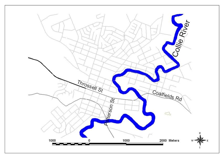
©                                    Centre of Excellence in Natural Resource Management,
                                     University of Western Australia.

TITLE                                COLLIE RIVER REVITALISATION PROJECT

PRODUCED BY                          PETER DAVIES, PETER SPELDEWINDE & COLIN
                                     MACGREGOR
                                     Centre of Excellence in Natural Resource Management,
                                     The University of Western Australia,
                                     P.O. Box 5771, Albany, WA 6332.
                                     Telephone: (08) 9842 0836
                                     Fax:       (08) 9842 8499

PRODUCED FOR                         Shire of Collie
                                     Throssell Street
                                     Collie WA 6225

CONTACT                              Jason Whiteaker, CEO

DATE                                 June 2008

PUBLICATION DATA                     Davies, P.M., Speldewinde P.C. and Macgregor, C. (2008).
                                     Collie River revitalisation project. Report No CENRM 067v2
                                     Centre of Excellence in Natural Resource Management, The
                                     University of Western Australia.

COVER IMAGE                          The Collie River near the present Townsite circa 1925. Image
                                     courtesy of the National Library of Australia originally from a
                                     WD and HO Wills cigarette card.

DISCLAIMER

This report has been prepared on behalf of and for the exclusive use of the Client, and is subject to and
issued in accordance with the agreement between the client and Centre of Excellence in Natural Resource
Management. The Centre of Excellence in Natural Resource Management accepts no liability or responsibility
whatsoever for it in respect of any use of or reliance upon this report by any third party. In particular, it
should be noted that this report is a professional assessment and opinion only, based on the scope of the
services defined by the Client, budgetary and time constraints imposed by the Client, the information
supplied by the Client (and its agents), and the method consistent with the preceding.

Centre of Excellence in Natural Resource Management could not attempt to verify the accuracy or completeness
of all information supplied. Copying of this report or parts of this report is not permitted without explicit
authorisation of the Client and the Centre of Excellence in Natural Resource Management.

                                             Page 2 of 80
Table of contents
Table of contents .......................................................................................................................... 3
Tables.............................................................................................................................................. 4
Abstract ............................................................................................................................................ 5
Background ....................................................................................................................................... 9
   Collie River Catchment.......................................................................................................... 12
   Vegetation................................................................................................................................ 14
Climate Change............................................................................................................................... 15
Aboriginal Heritage......................................................................................................................... 15
      Collie Townsite reach .............................................................................................................. 16
Recommendations............................................................................................................................. 29
   Catchment scale ...................................................................................................................... 29
   Collie Reach............................................................................................................................. 29
      Mechanical or chemical removal............................................................................................... 30
      Restoration of environmental flows........................................................................................... 31
      Restoration of riparian vegetation ............................................................................................ 32
   Funding sources...................................................................................................................... 39
      Risk assessment...................................................................................................................... 40
Public Participation..................................................................................................................... 42
References ......................................................................................................................................... iii

                                                               Page 3 of 80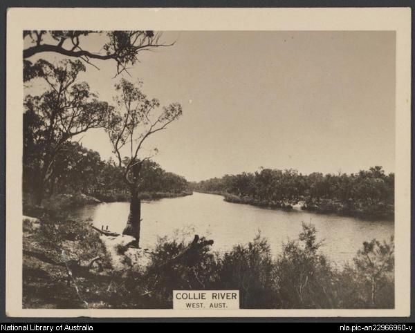
Tables
Table 1: Catchment and river condition scores for the Collie River catchment from the
National Land and Water Resources Audit (NLWRA 2002). .............................................. 13
Table 2: Channel cross sections at the townsite and the measured velocities required to
dislodge Nardoo. ......................................................................................................................... 27
Table 3:Environmental flows to scour Nardoo....................................................................... 27
Table 4: Ecological Water Requirements of water dependent ecosystems in the Collie
River adjacent to the townsite................................................................................................... 27
Table 5: Parameters involved in the control of Nardoo......................................................... 28
Table 6 : Approximate length, areas and estimated costs of revegetation for the three
priority classes of revegetation and the length of stretches of existing vegetation along
the Collie River Townsite reach. (note: area calculation based on revegetating a 10m
strip along the river bank).......................................................................................................... 34
Table 7: Approximate costs of revegetation, assuming native vegetation is planted in
revegetation areas and does not include labour (Costs estimated from Schirmer and Field
(2001))........................................................................................................................................... 34
Table 8: Table showing actions required in order of implementation and party responsible
for implementation for Option2-chemical control of Nardoo. ........................................... 35
Table 9: Table showing actions required in order of implementation and part responsible
for implementation of Option 3-seasonal removal of stop-boards..................................... 36
Table 10: Actions required in order of implementation and part responsible for
implementation of Option 4-restoration of environmental flows and installation of
riffles. ............................................................................................................................................ 37
Table 11: Table showing actions required in order of implementation and part responsible
for implementation for restoration of riparian vegetation.................................................... 38
Table 12: Monoitoring regime for the Collie River................................................................. 38
Table 13: Estimated risk of assorted actions associated with the restoration of the Collie
River Townsite reach (*assumes that revegetation is carried out in conjunction with
environmental flows). ................................................................................................................. 41
Table 14: Estimated relative cost for assorted actions associated with the restoration of
the Townsite reach...................................................................................................................... 42

                                                               Page 4 of 80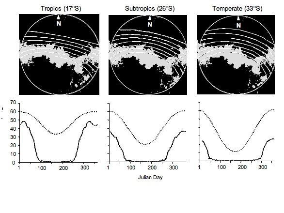
Abstract
  •   Collie River in southwestern Australia is characterized by agricultural and urban
      development in the catchment and associated flow regulation.
  •   A reach near the Collie Townsite has been infested by the macrophyte Nardoo
      leading to a reduction of visual amenity and flood conveyance of the river.
      Although native to Western Australia, Nardoo was not historically present in the
      Collie River.
  •   Nardoo growth has been enhanced by low and constant river flows (due to
      stopboards), nutrient status (leakage from agricultural landscapes) and high light
      inputs (through the lack of riparian [streamside] vegetation).
  •   These three parameters influence Nardoo at different spatial scales; nutrients at
      the catchment level, flows at a reach scale and light has a more local impact.
  •   Controlling or modifying these three parameters is fundamental to river health
      and, as a consequence, control of Nardoo. Catchment management and the
      maintenance of river health should address broad issues; by controlling these,
      Nardoo will also be reduced or removed. Other management methods of
      Nardoo control including chemical or mechanical removal. However, these are
      not considered appropriate as the underlying determinants of Nardoo growth
      have not been controlled.
  •   The largely agriculturally-derived nutrient phosphorus (P) limits aquatic plant
      growth in the Collie River. This nutrient is generally transported into the river by
      overland flows from the surrounding catchment. Riparian revegetation is
      considered the appropriate intervention, at targeted reaches, to reduce
      phosphorus inputs.
  •   Based on local experimentation and nutrient guidelines, the long-term target for
      phosphorus at the Townsite should be set at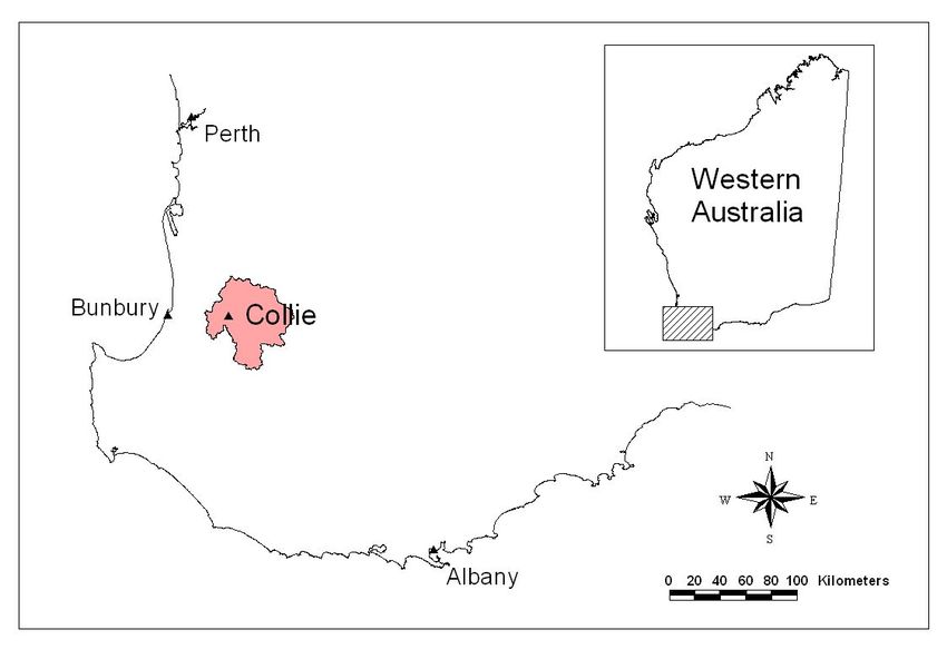
•   Environmental flows are critical to scour sediments (associated with Nardoo) and
    physically displace the plants downstream. Environmental flows should be based
    on the “historic flow paradigm” that is flows based on the pre-regulation
    hydrograph.
•   These environmental flows can be delivered, by management or complete
    removal of the stopboards. For solely ecological reasons, the stopboards should
    be removed; this will enable environmental flows through the Townsite reach
    and if managed carefully, will scour the Nardoo and associated sediments. As
    these boards are currently in poor condition and may need replacement
    evaluating their role is timely. Dense stands of Typha and other introduced
    species have established downstream of stopboards due to low and constant
    flows. In about 5-10 years, these stands will colonise downstream reaches and
    dominate the pool under the Mumballup-Collie Rd Bridge.
•   If stopboards are removed, consideration has to be made of other consumptive
    users. With removal, less water will be impounded and available for other users.
    At present, the Eden Park Golf Club, Collie Golf Club, Collie High School and
    the Shire withdraw water from the Collie River near the Townsite. Although rates
    of abstraction are not well-known, based on pipe diameters, advice from the
    Shire and where possible, licence conditions, it is estimated that about 500,000
    litres a month (e.g. 133,000 L/month used by the Shire during the dry season, A
    Watts Shire Planner pers comm.) are used during the dry season. This equates to a
    small volume (10L/min) (and is possibly an underestimate; for example a 4” pipe
    at the Golf Club has the capacity to transmit 8-10L/s which is 700,000 L/day).
    Should the 500KL/month be a reasonable approximation, stopboard removal
    and a reduction of standing water is not expected to limit the current rates of
    abstraction.
•   Should rates of dry season abstraction be an underestimate, and therefore not
    able to be sustainably abstracted after stopboard removal, riffles may need to be
    constructed. Riffles will enable small pools to form and increase the standing
    water available for abstraction.

                                   Page 6 of 80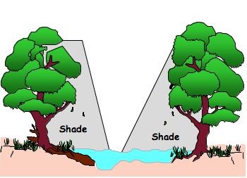
•   If feasible, stopboard removal is the preferred option for Nardoo management.
    For maximum benefit, the most downstream stopboards should be removed
    first, then after about a week, the upstream removed. In this way, the stage
    height will be at a minimum and with removal of the upstream stopboards, a
    scour will remove accumulated sediments and Nardoo.
•   With stopboard removal, there are some risks which need to be assessed in a
    social context. A large scouring flow after board removal will transmit sediments
    downstream (to Minninup Pool). In the reach between the upstream stopboards
    and the Mumballup-Collie Rd Bridge, it is estimated that up to about 4-10,000 m3
    of accumulated sediments could be liberated by significant scouring flows.
    Stopboard removal will fundamentally alter the nature and volume of
    downstream pools. A lowering in pool volumes may reduce the visual amenity as
    the exposed mud in the pool margins will be visible until colonised by vegetation.
    The trade-off between environmental flows (delivered largely by stopboard
    removal) and a medium-term change to downstream systems including Minninup
    Pool is a social issue requiring informed debate.
•   Environmental Water Provisions (EWPs) are the trade-off between Ecological
    Water Requirements (EWRs) and other consumptive users; this is the relevant
    process for stopboard management.
•   Should stopboards not be removed, managed flows could be used to scour the
    Nardoo. This requires a flow rate of about 20cm/s. This flow is needed during
    summer and autumn for at least four hours. Given the high primary productivity
    of Nardoo (~3g.m2.day-1), these flows need to be delivered every week (or based
    on observation).
•   Due to channel form and bed roughness, water velocity drops to almost zero at
    the river margins and consequently flows, in these littoral regions, will have little
    influence on Nardoo removal.
•   In these margins, light attenuation can be used to control Nardoo growth.
    Riparian revegetation, particularly on the north bank (the river runs east-west at
    the Townsite maximizing light inputs) will help shade out the Nardoo in the
    margins. The target value is
• Controlling these three parameters; nutrients, flows and light incorporates three
temporal scales. Flows can be managed immediately (stop-board management),
light attenuation (riparian replanting will require vegetation to reach a sufficient
height) and nutrients will require a long-term approach at the catchment scale
(again with riparian restoration).
• Restoration of the Collie River should be developed with appropriate Traditional
Owner input.
• A recommended implementation plan for local works is outlined over-page. It
should be noted, this assumes an overarching catchment management plan.
Recommendations:
1. Assess feasibility of establishing environmental flows by management and/or removal of
stopboards. Removal is the preferred option for ecological purposes.
2. Inform stakeholders the trade-off between environmental flows and changes to downstream
pools.
3. Fence and re-plant riparian vegetation at the “Townsite” (focusing on the north bank).
4. Map areas of nutrient “leakage” from the upper catchment and initiate a riparian restoration
program at these sites.
5. Liaise with appropriate authorities to develop a catchment-scale integrated management plan.
6. Investigate funding opportunities for funding for restoration activities.
Next steps
1. Inform stakeholders of the trade-off between aesthetic, ecological and other uses (i.e. water for
summer fire-fighting).
2. Investigate engineering issues associated with complete stopboard removal.
3. Refine estimates of dry season consumptive use. This will be required to establish if riffles re
requires or if river flows will be sufficient.
4. Develop a catchment-scale restoration plan in association with government agencies.
5. Develop proposals to funding partners for on-ground works.
Page 8 of 80Recommended local implementation plan
Timeline Action
Summer 2008/ Autumn 2009 Refine dry season estimates of
consumptive use by schools, golf course
and schools.
Summer 2008 Based on the above, if needed, design a
riffle-pool complex (based on riffles placed
at 6x river width).
Spring/ Summer 2008 Outline to stakeholders, environmental
trade-offs (including possible reduction of
amenity to downstream pools)
Summer 2008 Order seeds/seedlings for 2009 plantings
Autumn 2009 Redesign or remove stopboards
Winter/Spring 2009 Commence revegetation in areas not
requiring weed control
Mid-late 2009 Commence weed control
Late 2009 Order seeds/seedlings for 2010 plantings
Pre winter 2010 Complete 12 month assessment of Nardoo
control methods
Winter/Spring 2010 Commence revegetation in weed control
areas
Page 9 of 80Background
The rivers of south-western Australia are characterised by varying levels of degradation.
The larger rivers systems with headwaters to the east of the Darling Scarp (Swan-Avon,
Blackwood and the Murray), are influenced by secondary salinisation and, as a
consequence, are not impounded for water supply (1992). In contrast, the shorter (first
and second order) streams arising on the west of the Darling Scarp are fresh and almost
all have been regulated for supply (Kite et al. 1997). The Collie River is a major river
system in the south-west flowing through the town of Collie in south-western Australia
(Figure 1 and Figure 2). The river has been impacted by a range of land-uses and
substantial levels of regulation (e.g. Harris River Dam, Wellington Dam). The river is
considered a major environmental asset for Collie and the causes of degradation of the
8km stretch through the Townsite has been contentious, in particular the presence of the
aquatic plant Nardoo (Marsilea mutica) (Anon. 1999; Beckwith 2007).
As part of the Collie River Revitalisation Project the Shire of Collie commissioned the
Centre of Excellence in Natural Resource Management, The University of Western
Australia (CENRM) to provide a report with recommendations for the following specific
objectives-
a. sustainably manage endemic Nardoo and eradicate/control weeds associated with the river
b. acknowledge and preserve the various recreational pursuits associated with the river (fishing,
canoeing etc)
c. ensure the identified sections of the river remain aesthetically appealing (high water level in
summer) which recognises and promotes the river as a community asset
d. recognise and conserve the Aboriginal cultural history associated with the river
e. provide recommendations and initiatives as to the management of the hydrological regime in this
section of the river to best achieve and comply with all of the above outcomes.
Page 10 of 80Figure 1: Map showing the location of the upper Collie River catchment.
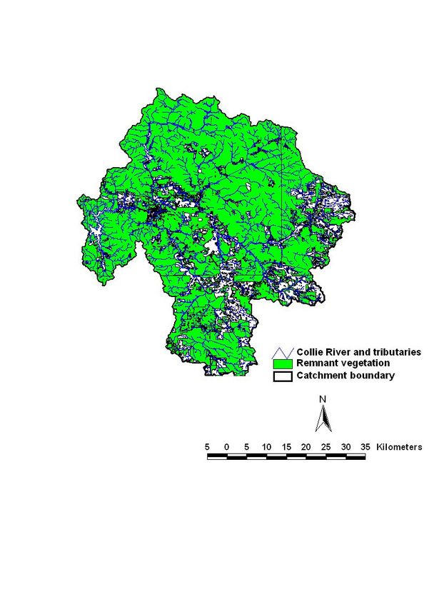
Figure 2: Map of Collie River through Collie Townsite.
Page 11 of 80Collie River Catchment
The Collie River upstream from the Wellington Dam is a Water Resource Recovery
Catchment described the Western Australian State Salinity Strategy and covers an area of
2827km2 (Mauger et al. 2001). The goal of the recovery catchment approach is to
maintain or restore the quality of water at the potential or existing dam sites to potable
levels (Lothian and Conacher 2005). The Collie River is influenced by secondary
salinisation in its upper reaches but becomes less saline with fresh water tributaries
draining forested and high rainfall areas (Davies 2003; Anon. 2007b). There are two
dams in the catchment, the Harris and Wellington. The Harris River Dam is located on
a fresh water tributary of the Collie River, upstream from the Collie Townsite. The
Wellington Dam is located downstream of the Collie Townsite and was built in the 1930s
to supply irrigation water and also to supply towns in the Great Southern region with
water (Anon. 2007b). Currently water from the Dam used only for irrigation (Anon.
2007b). Mauger et al. (2001) suggested a range of options to reduce salinity levels in the
Collie River, with the aim increasing water quality in Wellington Dam; which is
considered a future domestic source.
The major mining activity in the catchment is the extraction of coal (Anon. 2007b). The
Collie Coal Basin is a declared Groundwater Management Area (Anon. 2007b); the
groundwater from this basin discharges into the Collie River and tributaries.
Groundwater is withdrawn from the coal basin to ensure mine workings are more stable.
A recent stakeholder consultation in the catchment (Beckwith 2007) found that although
stakeholders recognised the need for abstraction of groundwater, many expressed
concern about the rate of water withdrawal. Concerns over the withdrawal of
groundwater included the potential for a reduction in flow in the Collie River south
branch, less water in river pools and land subsidence (Beckwith 2007).
The majority of the upper catchment is forested and, in the 2002 National Land and
Water Resources Audit (NLWRA 2002), the catchment was described as in “moderate”
condition compared to other catchments in Australia (Table 1).
Page 12 of 80Table 1: Catchment and river condition scores for the Collie River catchment from the National Land and
Water Resources Audit (NLWRA 2002).
Catchment condition Score Description
Catchment land condition 3 Moderate condition
Catchment water condition 4 Moderate-better condition
Catchment biota condition 3 Moderate condition
Catchment condition composite 4 Moderate-better condition
River condition Index Description
Aquatic biota index 0.95 Reference condition
Environment index 0.55 Moderately modified
Catchment disturbance sub-index 0.7 Moderately modified
Hydrological disturbance index -
Nutrient and suspended sediment load sub- 0.35 Substantially modified
index
Habitat sub-index 0.72 Moderately modified
Riparian vegetation 0.93 Largely unmodified
Geomorphic setting
The Darling Range is the uplifted edge of the Yilgarn Block, part of the Precambrian
Western Plateau (Great Plateau) which extends to the Goldfields. The Darling Range, as
part of the Great Plateau, is an area of ancient, weathered rock (Bettenay and Mulcahy
1972) which, historically, has resulted in the very low nutrient status of upland streams
(Bunn and Davies 1990). In contrast, the mean concentration of total phosphorus and
total nitrogen in lowland rivers is about 30 times greater than upland streams primarily
due to clearing, cultivation and drain construction on the Coastal Plain (Anon 1997).
The Swan Coastal Plain is a deep sedimentary trough consisting largely of sandy Aeolian
soils with a sequence of alluvial clay soils along its eastern part. Soils of the Coastal Plain
and the foothills are Pleistocene-Holocene in age while the Darling Range is dominated
by Tertiary laterites over Achaean granites and metamorphic rock (Marchant et al. 1987).
Page 13 of 80Vegetation
The lateritic soils of the Collie River catchment region of the Darling Range overlie
granitic bed-rock and support a dry sclerophyll forest which is dominated by jarrah
(Eucalyptus marginata), with marri (Corymbia calophylla) in some valleys (Shea et al. 1975).
This overstorey is sometimes replaced by other eucalyptus species including Blackbutt
(E. patens), bullich (E. megacarpa) and flooded-gum (E. rudis) (Bell and Heddle 1989).
Some woodland areas are severely affected by jarrah dieback (Phytophthora sp.). Blackbutt
and flooded gum are common along less degraded watercourses.
Historically, the understorey plants would have been dominated by white-myrtle
(Hypocalymma angustifolium), Trymalium ledifolium and Astartea fascicularis. However, very
little of this understorey remains and the riparian understorey was characterised by dense
sclerophyllous shrubs (e.g. Agonis linearfolia, Hypocalymma angustfolium, Calytrix glutinosa and
Hakea costata) and sedges. Wetland and riparian vegetation on the Coastal Plain typically
includes flooded-gum (Eucalyptus rudis), Melaleuca preissiana and M. rhaphiophylla over heath
(e.g. Astartea fasicularis, Pericalymma ellipticum var. ellipticum, Regelia ciliata, Hypocalymma
angustifolium) and sedgelands.
Climate
The climate of the Collie region is Mediterranean with hot, dry summers and cool, wet
winters (Seddon 1972). Average annual rainfall for the study area is approximately 1200
mm. Maximum rainfall typically occurs between May – September. Average annual
evaporation rates for the catchment vary from 1200mm to 1600mm, with monthly rates
of between 50 mm in June and 300 mm in January (Welker and Davies 2001a). Rainfall
is both seasonal and highly predictable however, the Harvey region has received below
average rainfall for the last 20 years (Welker and Davies 2001a).
Page 14 of 80Climate Change
Southwestern Western Australia has experienced a significant decline in rainfall since the
1960s (CSIRO 2001). Based on current models for global warming, CSIRO (2001) has
predicted (by 2030) an increase in temperature for the south-west and a decreasing trend
(-20% to +5%) in winter and spring rainfall and a ±10% change in summer/autumn
rainfall. While the intensity of specific winter rainfall events may increase, their duration
is expected to decrease. Correspondingly, the duration of drought events and rates of
evaporation is also predicted to increase. The 20% decrease in south-west rainfall over
the last 30 – 40 years has resulted in a 40% decrease in annual streamflow (CSIRO 1996).
Aboriginal Heritage
River restoration of the Collie River should take into account the presence of Aboriginal
sites within the 8km Townsite reach and full consultation with Aboriginal communities
should be undertaken prior to the commencement of any works.
According to the Aboriginal Heritage Inquiry System (accessed December 2007) there
are five registered Aboriginal sites along the Collie within the Townsite-
• Telfer Pool (site ID 4579) (ceremonial site)
• Collie Spring (site ID 4699) (mythological and historical site)
• Ewington Spring (site ID 15333)
• High Chaparral Camps (site ID 15335)
• White City Camp (site ID 16003)
Collie River itself is listed as a registered site (site ID 16713) not only as a water source
but also it has significance in relation to the Waugal. It must be noted that not all existing
Aboriginal sites have been recorded.
Under the Aboriginal Heritage Act 1972 approval must be obtained from the Minister for
Indigenous Affairs for activities on Aboriginal sites, including activities such as river
restoration (Bucktin 2002). Anyone carrying out river restoration activities on Aboriginal
sites should also be aware of their obligations under the Commonwealth Native Title Act
1993 and the Aboriginal and Torres Strait Islander Heritage Protection Act 1984.
Page 15 of 80If Ministerial approval requires application forms which are available from the
Department of Indigenous Affairs. The application will require project details including;
location, description of works, consultation process with Aboriginal people, outcomes of
the consultation process and any relevant heritage survey reports (Bucktin 2002).
Collie Townsite reach
The Collie River flows through the Collie Townsite (Figure 2) about 150kms south of
Perth. In response to significant 1963/4 flooding, the river near Collie was both
deepened and widened and fringing vegetation was removed in the vicinity of the Collie
Townsite to encourage the unimpeded conveyance of water (Anon. 1999).
A recent stakeholder meeting (Macgregor et al. 2007) to address issues of the degradation
of the Townsite reach of the Collie River noted the main issues of concern was the
abundance of the aquatic plant Nardoo, Marsilea mutica (Macgregor et al. 2007) (in some
reports the species of Nardoo recorded in the Collie River has also been referred to as
Marsilea drummondii). Although Nardoo is a native plant to south-western Australia
(McCarthy 1998), it is considered an invasive species in conditions such as the current
situation in the Collie River (Pen 2000). It is also a noted water weed in New Zealand
(ARC 2007) and a garden pond species in Australia (Sainty and Jacobs 1988). It has
been noted that the Nardoo in Townsite reach of the Collie River became more
prevalent after the 1964 and 1984 floods (Beckwith 2007). It was thought that the
removal of shading vegetation has given the Nardoo the opportunity to proliferate and
may contribute to a longer growth period (Anon. 1999). The two weirs (maintained by
stopboards) on the Collie River adjacent to the Townsite also maintain permanent bodies
which also could encourage Nardoo (Anon. 1999) through the reduction in water
movement and the resulting deposition of sediments (see Bunn et al. (1998) for a
description of the mechanism).
The main consideration for the removal of Nardoo from the Collie River are for
aesthetic values (Beckwith 2007; Macgregor et al. 2007), although it should be noted that
Nardoo is toxic to stock and has been shown to cause Polioencephalomalacia (disease of the
central nervous system caused by thiamine deficiency) in ruminants (Aplin et al. 1983;
Abbott and Maxwell 2002). In addition, weed infestations can strip oxygen from river
systems resulting in diel fish-kills.
Page 16 of 80An Action Plan for the town site reach of the Collie River produced in 1999 (Anon.
1999) aimed to produce a description of the state of the Collie River in the Collie
Townsite and to prioritise actions to address river degradation. The Collie River
Foreshore Management Plan (Anon. 1999) had two management considerations
regarding Nardoo-
• ‘long term management should monitor the growth of native nardoo to determine
its cycle of growth’
• ‘measurement of the associated level of sediment that may raise the bed level should
be also undertaken to ascertain and quantify any relationship. Significant
sedimentation that may raise the bed of the channel should be prevented’.
Control of Nardoo
As the case with all aquatic plants, growth is generally controlled by light, nutrients and
temperature (Bunn, Davies, Kellaway et al. 1998) and distribution can regulated by flow,
particularly scour (Wilson et al. 1996). It should be noted a large stand of Typha has
established immediately downstream from the upstream stopboards. This is probably a
consequence of the low and constant flows downstream of the boards. Typically, variable
(“natural”) flows inhibit colonisation by introduced species. The stand of Typha will
inhibit flows and cause the settlement of sediments and therefore increase the extent of
the plants. It is estimated that in about 5-10 years, the Typha will choke the reach of the
river under the Mumballup-Collie Rd Bridge.
Limiting nutrients
The distribution and growth of Nardoo and other aquatic plants in the lower Collie River
is controlled, in part, by high nutrient levels in the surrounding water and local light
input. Generally, freshwater plants uptake nutrients in well-known proportions during
growth. These proportions are typically C:N:P (Carbon: Nitrogen:
Phosphorus) = 106:16:1 and termed the Redfield Equation (Sainty and Jacobs 1988). A
variation in the N: P ratio in the water column illustrates which nutrient is “limiting”
plant growth. In the Collie River, the ratio of N:P of ~22:1 (Davies 2000) indicates
phosphorus is the limiting nutrient for plant growth. Consequently, small changes in
phosphorus concentrations can have a large effect on plant growth rates.
Page 17 of 80This nutrient is typically transported into streams and rivers by overland flows from the
surrounding catchment. In contrast, the movement of nitrogen is more influenced by
sub-surface flows (see National Riparian Guidelines 2002). Consequently, management
of surface flows into rivers from the surrounding catchment can have a
disproportionately important influence on downstream plant growth. In these cases,
riparian (streamside) vegetation is the appropriate management intervention for the
control of phosphorus-rich flows as it acts as a buffer between agricultural landscapes
and the river (Ramos-Escobedo and Vázquez 2001; Rosemond et al. 2002). The problem
with high plant growth (primary production) is this is not necessarily incorporated into
secondary production (Davies et al. 2008). This leads to high a standing biomass of plant
material in river channels causing high oxygen demand (and often fish-kills) and a
reduction in the conveyance of flows. High primary production (as standing biomass) is
also often considered aesthetically unpleasant.
The majority of the upper Collie catchment is reasonably well-vegetated (Figure 3). The
main region where the vegetation is minimal is the eastern and south eastern tributaries.
Page 18 of 80Figure 3: Remnant vegetation in the upper Collie catchment (data from NLWRA 2001).
Page 19 of 80Light inputs
Light is fundamental to plant growth. An increase in light intensity into rivers tends to
shift the aquatic plant composition from palatable microalgae to filamentous algae and
macrophytes, which are not readily grazed by consumers (Bunn, Davies and Mosisch
1998). Nardoo, an aquatic macrophyte, grows readily in the high light environments in
the Collie River near the Townsite. The largely cleared riparian (streamside) vegetation at
the Townsite minimises the influence of shade on plant growth. Light input is a function
of topographic shade (the shape of the river bank), vegetative shade (from the riparian
zone) and channel morphology (see Figure 4) (Davies et al. 2004). As the river is largely
orientated east-west near the Townsite, the sun “tracks” down the channel, maximizing
the light input (Figure 5). Figure 4 shows Collie at a latitude of about 33˚ south (the right
hand plot), has the sun tracking to the north of the channel and consequently shading by
vegetation on the north bank to shade the channel will have a larger effect than the south
bank.
Figure 4: Shading of the river channel by riparian vegetation.
Page 20 of 80Figure 5: Images of the riparian canopy above a stream showing the effect of latitude (tropics,
subtropics and temperate zone). The white curves indicate the trajectory of the sun during each month of
the year (Bunn et al. 1999). The associated graphs show estimated photosynthetically-active photon flux
density (PPFD) above canopy (dotted line) and below canopy (solid line) throughout the year (figure after
Davies et al. (2008)).
Stream flows
Physical disturbance of the river from episodic or seasonal high flow events can have a
major effect on macrophyte biomass in rivers (Pringle and Hamazaki 1997; Townsend
and Padovan 2005). High flows remove and transport plants directly and scour the
sediments upon high they grow (Bunn, Davies, Kellaway et al. 1998). The stopboards in
the Collie River at the Townsite result in pond-like conditions which encourage the
deposition of sediments. The Collie River, typical of many Australian rivers, is probably
still generating sediment as a consequence of land management practices (Lovett and
Price 1999). The absence of large scour flows results in the sediment remaining un-
transported. Flows managed to maintain ecological values are termed environmental
flows.
Page 21 of 80Environmental Flows
Environmental flows typically termed ecological water requirements (EWRs) and are
defined by the Water and Rivers Commission (now Dept of Water) as: “the water regimes
needed to maintain ecological values of water dependent ecosystems at a low level of risk.” (Anon 1997).
The COAG water reform agenda considers that EWRs are based on the premise that the
environment has a right to water; that is it has to be regarded as a legitimate user.
Consistent with this approach, the terminology used in this report is based on the
National Principles for the Provision of Water for Ecosystems (Anon 1996) where:
• Ecological Water Requirements (EWRs) describe water regimes (spatial and temporal)
needed to sustain the ecological values of water dependent ecosystems at a low level
of risk.
• Environmental Water Provisions (EWPs) are that part of the ecological water
requirements that can actually be met after further consideration of social and
economic factors (Pigram and Hooper 1992).
In the Collie River, other “factors” include maintaining aesthetic values and ensuring
water for fire-fighting purposes. The trade-off will be between these and the ecological
assets.
In the case of the Collie River township site, the important ecological issue controlled by
river flow is the maintenance of channel form; that is the shape of the natural river form
and the water quality of riverine pools (particularly in summer/autumn).
Flushing flows can be used to remove accumulated sediment and uproot introduced
aquatic plants (e.g. Nardoo). Flows to remove sediments and dislodge Nardoo would
mimic the historic flows.
Page 22 of 80On-site assessment
Sites in the Collie River at the Townsite were measured on-site to determine
environmental flows.
1. Channel maintenance.
Flow requirement: Significant flows are required to maintain the active channel
morphology and scour accumulated material from pools associated with the stop-boards
(e.g. sediment, detritus etc) and inhibit further Nardoo incursion into channels.
Underlying theory: In-stream flows influence channel form through physical processes
such as pool scouring (Arthington et al. 1994). Elevated flows are often required to
maintain existing (or active) channel dimensions, preventing the accumulation of
sediment and organic debris in river pools and prevent encroachment by riparian
vegetation and weeds. Disturbances from high-flow events can also be important in
structuring benthic communities and may influence ecosystem function (Resh et al.
1998). Scour of riverbeds, and undercutting of banks, is often essential for producing
diversity of habitat, particularly for native fish.
2. Maintenance of pool water quality (dissolved oxygen).
Flow requirement: Flows to maintain adequate dissolved oxygen levels in channel pools.
The Collie River catchment is still “generating” sediment, which has aggraded pools and
therefore reduced habitat area. Consequently, pool volumes may now be insufficient to
ensure satisfactory water quality particularly given the high oxygen demand of the
Nardoo and associated epiphytes.
Underlying theory: Sufficient water volumes are required over summer to ensure sufficient
water volumes and adequate dissolved oxygen of the pools. Generally, values of
dissolved oxygen> 2mg/L are required for aerobic processes. Adequate water quantities
“buffer” the effect of high benthic respiration and other processes which remove
dissolved oxygen from pools.
The determination of the flow requirements for the management of Nardoo required on-
site assessment of the channel cross sectional profile (see Figure 6).
Page 23 of 80Central channel
Bankfull height / stage
Present flow
Bankfull width
Figure 6: Measurements of channel morphology in the Collie River.
The active channel width and depth were determined as per the methodology outlined in
Newbury and Gaboury (1993). To measure discharge, a narrow segment (control point)
of the stream of uniform shape was selected and velocity measured using a field velocity
meter (Marsh McBirney Model 201M). Discharge volume (Q) was calculated using the
relationship:
Q = average width × average depth × average velocity.
Discharges were calculated using Manning’s Equation:
Qbf=AR 2/3.S 1/2./nbf
where R = hydraulic radius of flow (=cross sectional area of flow/
wetted perimeter of flow), S = slope of the energy gradient, n =
Manning’s roughness factor
(Newbury and Gaboury 1993).
Manning’s n was solved by substitution in the Mannings’ Equation (see above).
Page 24 of 80Results of field work
(a) Assuming Stopboard Management
The following sections assume that the stopboards can be managed to deliver
downstream flows (it does not assume their removal).
The channel at the Townsite was about 52m in width and approximately 2m deep (Table
2). Gabion deflectors were used in a previous study (Welker and Davies 2001a) to
estimate flows required to mobilise Nardoo. This experiment showed flows between
about 19 and 23 cm.sec-1 dislodged the Nardoo and transported plants downstream
(Table 3). With the measured cross sectional area (about 80-95m2) and the required
dislodgement velocity (~20 cm.sec-1), this relates to a discharge of between 18 and 23
m3.sec-1). This is a considerable flow (>1700 ML/day) and possibly beyond the volumes
of water available in the Collie catchment near the Townsite.
In the reach between the upstream stopboards and the Mumballup-Collie Rd Bridge, it is
estimated (by cross sectional profiles and measuring depth of sediment) that about 4-
10,000 m3 of accumulated sediments are in the reach. Should these sediments be
liberated, they would have impact on downstream systems.
Previous measurements of the growth of Nardoo (during summer) (Welker and Davies
2001a) showed high rates of about 3.5mg.m2.day-1. These values are approaching rates
recorded in hydroponic settings (Hoagland and Arnon 1950). Given these growth, flows
to scour Nardoo would need to be “delivered” once a week during late summer/
autumn. The duration of the scouring flows needs to be at least four hours (based on
personal observation). Table 4 shows the summary of flow requirements to control
Nardoo. Inclusion of the ecological water requirements of other identified water-
dependent ecosystems is shown in Table 4. Flows for the maintenance of the water
quality of pools requires a “trickle” flow to ensure the dissolved oxygen concentrations
do not get lower than the critical 2mg/L levels. Flows to scour pools of accumulated
sediments require (unimpeded) flows of about 17,000ML/day (given the cross sectional
area of about 100m2) and the Mannings n (roughness) factor of 0.04.
Elevated flows are also required to connect the upper and lower reaches of the Collie
River network. Analyses conducted in other southwest river systems (Davies 1993,
Page 25 of 80Welker & Streamtec 1998, Davies et al. 1998) have shown upland reaches to be reliant on
the input of terrestrial carbon from forested lands (Figure 7).
(b) Stopboard Removal
The results of experimentation can also be interpreted in the context of stopboard
removal. Stopboard removal is a realistic management option particularly as the current
boards require maintenance and possibly replacement.
With stopboard removal, flows will be transmitted downstream more mimicking the
historic hydrograph. This is expected to remove Nardoo and with management of
stopboard removal, the scour flows could be used to liberate sediments. To achieve
maximum scour, the downstream stopboards should be removed first, then after about
seven days, the upstream boards removed. Removing the downstream boards first will
lower the water level (stage height) ensuring the flows when released from the upstream
reach will have more tractive force over river sediments.
Risks include local erosion and infilling of downstream pools with sediment. For
example, about 4-10,000m3 of sediments could be liberated from the reach between the
upstream boards and the Mumballup-Collie Rd Bridge.
Other consumptive users
Establishment of environmental flows by stopboard removal will reduce the volume
of water in pools and therefore available for other consumers. At present, the Eden
Park Golf Club, Collie Golf Club, Collie High School and the Shire withdraw water
from the Collie River near the Townsite. Although rates of abstraction are not well-
known, based on pipe diameters, advice from the Shire and where possible, licence
conditions, it is estimated that about 500,000 litres a month (e.g. 133,000 L/month used
by the Shire during the dry season, A Watts Shire Planner pers comm.) are used during the
dry season. This equates to a small volume (10L/min) (and is possibly an underestimate;
for example a 4” pipe at the Golf Club has the capacity to transmit 8-10L/s which is
700,000 L/day). Should the 500KL/month be a reasonable approximation, stopboard
removal and a reduction of standing water is not expected to limit the current rates of
abstraction.
Page 26 of 80Table 2: Channel cross sections at the Townsite and the measured velocities required to dislodge Nardoo.
Width (m) Mean depth (m) Nardoo flow Q ( m3.sec-1)
(cm.sec-1)
48.8 1.91 20.1 18.73
50.2 2.02 22.8 23.12
51.6 1.86 19.4 18.62
49.5 1.97 20.6 20.08
Table 3: Environmental flows to scour Nardoo.
Season Frequency Q ( m3.sec-1) Duration
Late summer/ autumn Once a week ~20 Four hours
Table 4: Ecological Water Requirements of water dependent ecosystems in the Collie River adjacent to the
Townsite.
Water Flow
Dependent requirement Season Approximate Management
Ecosystem Q (ML/week) options
Pool Water “Trickle” flow Summer/Autumn 56 Stopboards (low
Quality flows)
Nardoo “Pulsed” flow Summer/Autumn 288 Stopboards
(high flows)
Channel form “Scour” flow Winter 17,280 Unregulated
flows (e.g.
stopboard
removal)
The control of Nardoo involves three parameters (Table 5):
• Nutrient reduction (particularly Phosphorus)
• Decreased light (through shading)
• Pulsed summer flows
The management of these parameters operates at three spatial scales:
Nutrient management is a catchment issue
Flows is a reach issue and
Light is managed locally.
Page 27 of 80Table 5: Parameters involved in the control of Nardoo.
Parameter Process Spatial scale Temporal scale Target
Nutrients Reduce concentrations of Catchment Long-term (revegetation of P
summer/autumn removal of stop-boards, 20cm/s (for at least four hours
environmental flows). every week during
summer/autumn). Stopboard
removal
Light Reduce light inputs Local Medium term (local PPFDFigure 7: The River Continuum Concept of Vannote et al. (1980) model of riverine function
emphasising the linkages between ecological function and hydrology (figure modified after Bunn
1997).
Recommendations
Catchment scale
On overarching Recommendation is the further development of a Catchment
Management Plan – the 8km reach of the Collie River at the Townsite cannot be
considered in isolation from the upstream catchment (e.g. the DoW Report on Managing
Water in the Upper Collie (Anon 2007)).
Collie Reach
There are three possible options for the establishment of environmental flows and the
management of Nardoo in the Collie River:
1. mechanical or chemical removal
2. seasonal management of stop-boards (see Tables 2-4)
3. removal of stopboards
4. installation of riffles.
Page 29 of 80Mechanical or chemical removal
This is considered the least favoured option for the removal of Nardoo as it is labour
intensive and has the risk of pesticide use. If mechanical and chemical removal of
Nardoo is used it is still highly likely that reinfestation will occur as the conditions of the
river would not have been changed. If mechanical or chemical removal was selected as
the method for the removal of Nardoo the Auckland Regional Council (ARC 2007) has
the following recommendations-
• Begin treatment at top of catchments & work downstream;
• Care is needed with mechanical control as stem fragments resprout;
• Use combination of mechanical control & herbicide to give effective control;
• Spray with 100ml glyphosate/10L or 200ml diquat/10L.
It should be noted that the spraying of herbicides into waterways is not considered best
practice and should only be considered as a “last resort”. The implications of any
detrimental effects of chemicals on desirable plants or fish and other aquatic life as well
as the possibility of the water being used for irrigation or stock further downstream need
to be considered (Peirce and Pratt 2002). It should be noted that Wellington Dam is
down stream of the proposed restoration works and therefore the implications of any
pesticide use should be examined prior to commencement of any spraying.
Dredging of the sediments in the Townsite reach would remove not only the sediments
but also the Nardoo growing in the sediments. This option could be technically difficult
and would only be a temporary solution to the Nardoo as over time the sediments will be
replaced and the Nardoo will re-establish. Depending on the rate of sediment deposition
the mechanical removal may be required annually.
Page 30 of 80Restoration of environmental flows
The agreed program outcome from a recent stakeholders meeting was to “Restore as far
as is practical a more natural ecological flow regime to the Collie River” as it was felt that
“The unnatural flow regime of the Collie River has resulted conditions that encourage
the aquatic weed Nardoo” (Macgregor et al. 2007). Restoration of ecological flows for
the Collie River has been highlighted previously (Welker and Davies 2001b; Beckwith
2007). Currently the Nardoo are growing in the pools created by the stop-boards, the
reduction in flow causes sediments to precipitate out and the Nardoo grows in the
deposited sediment. Scouring of this sediment will reduce the abundance of Nardoo.
There are three possible options for the scouring of the sediment (1) mechanical
removal, (2) seasonal management of stopboards (3) permanent removal of stop-boards
and/or installation of riffles.
Seasonal management of stopboards
The removal of the stopboards over winter would allow scouring of the sediments over
the period when the rivers flow is greatest. Replacement of stopboards over to summer
would maintain pools over summer. The “pulsed” flows required to remove Nardoo
during summer/autumn (Tables 2-4), could be delivered by stop-board management.
Currently the stopboards are in a state of disrepair. If this strategy was to be
implemented the stop-boards would have to be repaired or replaced. The new stop-
boards should be suitably designed and constructed to ensure their structural integrity
and safe operation.
Page 31 of 80Permanent removal of stopboards and installation of riffles
Permanent removal of stopboards, for ecological reasons alone, remains the preferred
option the risks include having insufficient water for other consumptive users. However,
given the estimates of water use by schools, golf clubs and the Shire, large volumes of
pooled water are probably not required. However, should the estimates be too low,
constructed riffles can form smaller pools which could be available for these other
consumers.
A riffle is generally defined as a small rapid that forms an obstruction during low flows
(Torre 2001). As the riffle forms an obstruction pools form up stream of the structure.
Unlike weirs riffles become submerged during high water levels allowing the scouring of
the river bed to remove sediments. Riffles do not generally adversely affect the flood
capacity of a river channel (Torre 2001).
Prior to the construction of any riffles, a site survey should be undertaken to establish
the profile, slope, geometry and alignment of the river channel (Hey 1996; Torre 2001).
The installation of riffles in the Townsite reach of the Collie is an option should
increased water volumes be required (after board removal). Riffles will allow the river to
scour ‘naturally’ during higher water levels and reduce Nardoo. The riffles will also
preserve the river pools, although they may not be as deep, which maintains the aesthetic
qualities of the river.
Restoration of riparian vegetation
One of the factors influencing the proliferation of Nardoo is the lack of shading
vegetation which would normally reduce the amount of sunlight reaching the river and
restrict the growth of aquatic plants (Anon. 1999). The restoration of riparian
vegetation would serve three purposes. Firstly, the riparian vegetation would assist in the
reduction of nutrients available to Nardoo though the filtering of runoff in the
immediate vicinity of the problem areas and also competing for nutrients with Nardoo.
Secondly, the overhanging riparian vegetation would restrict the amount of light reaching
the water along the edges of the water and therefore restrict the growth of Nardoo.
Page 32 of 80It should be noted that as the river is quite wide the riparian vegetation would not be
able to shade the entire channel. The middle of the channel would be unshaded but, the
scouring provided by environmental flows would restrict the Nardoo growth in the
centre of the channel. Thirdly, restoration of the riparian vegetation would enhance the
aesthetics of the river as well as providing habitat for native fauna.
As noted previously, due to the latitude of Collie the vegetation on the northern banks of
the river provide the most shade. Therefore, revegetation is most important on the
northern banks to have the greatest shading effect on Nardoo. Figure 8 shows the
revegetation priorities for the Townsite reach of the Collie River, where the northern
banks are given the highest priority and southern banks are given the lowest priority.
It should be noted that restoration of riparian vegetation without the adoption of some
other form of control is not likely to have any effect on the abundance of Nardoo.
Figure 8: Map showing revegetation priorities and existing vegetation along the Collie River Townsite
reach.
Page 33 of 80Table 6: Approximate length, areas and estimated costs of revegetation for the three priority classes of
revegetation and the length of stretches of existing vegetation along the Collie River Townsite reach.
(Note: area calculation based on revegetating a 10m strip along the river bank).
Priority Length Area Cost
(assuming $2,190/ha
see Table 7 for cost
breakdown)
Existing vegetation 5.9km - -
High priority 3.4km 3.4ha $ 7,446
Medium priority 0.9km 0.9ha $ 1,971
Low priority 4.7km 4.7ha $10,293
Table 7: Approximate costs of revegetation, assuming native vegetation is planted in revegetation areas
and does not include labour (Costs estimated from Schirmer and Field (2001)).
Item Cost /ha
Site preparation (weed control etc) $ 350
Fencing $1,200
Seedlings $ 640
Total $2,190
Page 34 of 80Report on public consultation Report on management options
(Macgregor et al. 2007) (this report)
Ô Ó
Stakeholder review and
consultation
Ó Ð Ð Ô
Option 1 Option 2 Option 3 Option 4
Do nothing Chemical Seasonal Environmental
control of management flows and riffles
Nardoo of stop (Table 10)
(Table 8) boards (Table
9)
Ú Ú Ú
Restoration of riparian vegetation (Table 11)
Figure 9: Flow diagram showing the four options available for Nardoo control.
Table 8: Table showing actions required in order of implementation and party responsible for
implementation for Option2-chemical control of Nardoo.
Action Responsible body
1.Consultation with stakeholders Shire/Consultant/Stakeholders
2.Assessment of environmental impact Shire/Consultant
3.Obtain permission to spray in catchment Shire
waterway
4.Seek funding (if required) (see page 39 Shire/SWCC
for possible funding sources)
5.Set up monitoring and evaluation Shire/Consultant
protocols
6.Engage contractors for chemical spraying Shire
7.Chemical spraying of Nardoo Contractor
8.Monitoring and evaluation Shire/Consultant
Page 35 of 80Table 9: Table showing actions required in order of implementation and part responsible for
implementation of Option 3-seasonal removal of stop-boards.
Action Responsible body
1.Consultation with stakeholders Shire/Consultant/Stakeholders
2.Seek funding (if required) (see page 39 Shire/SWCC
for possible funding sources)
3.Set up monitoring and evaluation Shire/Consultant
protocols
4.Engage contractor for design and Shire
construction of stop-boards
5.Removal of old stopboards Shire/Contractor/Shire Engineer
6.Contruction and installation of new stop- Contractor
boards
7.Monitoring and evaluation Shire/Consultant
Page 36 of 80Table 10: Actions required in order of implementation and part responsible for implementation of Option
4-restoration of environmental flows and installation of riffles.
Action Responsible body
1.Consultation with stakeholders Shire/Consultant/Stakeholders
2.Seek funding (if required) (see page 39 Shire/SWCC
for possible funding sources)
3.Set up monitoring and evaluation Shire/Consultant
protocols
4.(if required) engage consultant to Shire
implement river survey and design riffles
5.Implement river survey and design riffles Consultant
6.(if required) engage contractor to Shire
construct riffles and remove old stop-
boards
7.Construct riffles and/or remove old Contractor/Shire Engineer
stop-boards
8.Monitoring and evaluation Shire/Consultant
Page 37 of 80You can also read