Management Plan for Moss Valley Woodlands Nature Reserve April 2016 - March 2021
←
→
Page content transcription
If your browser does not render page correctly, please read the page content below
Management Plan for
Moss Valley Woodlands Nature Reserve
      April 2016 – March 2021
Acknowledgements

Sheffield and Rotherham Wildlife Trust would like to thank the many individuals who
have contributed to the formulation of this management plan. In particular, thanks go
  to the Woodland Trust, Steve Clements, the Dronfield Footpaths and Bridleways
   Society, Moss Valley Woodland Reserve Advisory Group and the Moss Valley
   Wildlife Group. Additionally, thanks go to the users of Moss Valley Woodlands,
                   SRWT staff and trainees who have contributed.

Report by: Chris Doar

Sheffield and Rotherham Wildlife Trust

37 Stafford Road

Sheffield

S2 2SF

Tel: 0114 263 4335

Email: nature.reserves@wildsheffield.com

Website: www.wildsheffield.com

                                         2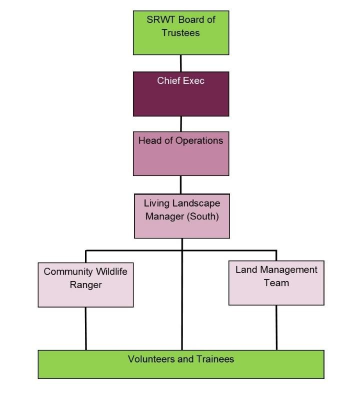
Contents
Summary

1.0   Introduction
      1.1     Purposes and formulation of the plan
      1.2     How to use this plan
      1.3     Vision statement and management aims
2.0   Site details
      2.1     Location and extent
      2.2     Landscape value and context
      2.3     Site ownership and tenure
      2.4     Designations and policy context
      2.5     SRWT staff structure for reserve management
      2.6     Site safety, security and maintenance
      2.7     Past and current land use
      2.8     Adjacent land ownership and use
      2.9     Services and site access
      2.10    Public Rights of Way
3.0   Environmental information
      3.1     Topography
      3.2     Geology and pedology
      3.3     Hydrology
      3.4     Climate
4.0   Biodiversity
      4.1     Biodiversity Action Plans
      4.2     Habitats
      4.3     Species
      4.4     Survey and monitoring
5.0   Infrastructure
      5.1     Walls and fencing
      5.2     Footpaths and bridleways
      5.3     Access furniture
      5.4     Interpretative features

                                             3
6.0 Cultural context
6.1 Site archaeology
6.2 Recreation
6.3 Community engagement
6.4 Outdoor learning
7.0 Economic
7.1 Past and present grant funding
7.2 Timber
7.3 Membership recruitment
7.4 Employment and training
7.6 Communication and marketing
8.0 Management aims and objectives
9.0 Work programme
10.0 Figures and tables
Figure 1. Location and extent
Figure 2. Public Rights of Way and concessionary routes
Figure 3. Adjacent land ownership
Figure 4. Location of services
Figure 5. Hydrology
Figure 6. Archaeology
Figure 7. Phase one map of woodlands
Figure 8. Woodland compartment map
Figure 9. Phase one map of Dowey Lumb
Table 1: BAP Priority habitats and species
Table 2. Access protocol for the reserve
APPENDIX 1: GLOSSARY
4Summary
Moss Valley Woodlands nature reserve covers 26.3 hectares of semi-natural ancient woodland,
scrub and grassland. It lies on the southern fringes of the city, adjacent to Norwood and Owler
Carr Wood, within the Moss Valley. The woods are the property of Sheffield City Council and
have been managed by the Sheffield and Rotherham Wildlife Trust (SRWT) since 2001.
Moss Valley Woodlands is a semi-natural ancient woodland. Historical research and
archaeological evidence suggests that the woodland was managed as coppice with standards in
the post-medieval period, reverting to mature woodland with a beech and sycamore component
by the Victorian period. Today the woods are designated as a Local Wildlife Site and contain
a Public Rights of Way network, including both footpaths and concessionary bridleways, which
provide access across the site. The reserve has long been used as a place for recreation, and
enjoyed by generations of Sheffielders for walking, picnicking, blackberry picking and horse
riding.
Moss Valley Woodlands nature reserve has numerous features of (biological) conservation
interest, including its areas of semi-natural ancient woodland, the ancient woodland ground
flora, the semi-improved grasslands of Dowey Lumb and several birds of conservation concern.
Together with adjacent woods, their age and continuity of use make the woodlands an
important historical site which must be managed to ensure that their unique characteristics, so
appreciated by its users, are retained.
This management plan covers the period from April 2016 to March 2021. Physical works
contained in the plan are aimed at conserving and improving the priority habitats on the site
and maintaining features of interest. Works to maintain and improve recreational infrastructure
are also included. A survey and monitoring programme will be implemented over the course
of the plan, providing data on ecological conditions which will inform future management
works.
In addition to these physical works, the Trust plans to engage the public in the management of
the reserve through the Reserve Advisory Group. On site information provision will be limited,
rather the site will be promoted through the Trust’s website. An annual programme of
volunteer work days and guided walks will be held to promote public understanding of its
wildlife and history and offer opportunities to participate in its management.
Through the implementation of this plan, the Trust intends to ensure the reserve remains true
to the vision:
Moss Valley Woodlands will be a place that offers visitors the opportunity to enjoy nature in a
peaceful, natural setting. Rich in wild flowers, birdlife and other wildlife, it will provide a
tranquil haven away from the bustle of everyday life, where people of all ages can come to
relax and explore. A network of well-maintained footpaths and bridleways offer a variety of
walks and rides, through woods and along streams, and will link the reserve to the wider
landscape of the Moss Valley. Users of the area will be encouraged to have a sense of
ownership over the woodland and participate in its management.
5Management of the woodlands will be sustainable and will contribute to the local economy
where possible. The woods will be managed in the context of the wider landscape, with the
Trust working with adjacent woodland owners, farmers and others, as necessary, to achieve
this.
61.0 Introduction
Moss Valley Woodlands nature reserve covers 26.3 hectares of semi-natural ancient woodland,
scrub and grassland. The reserve lies on the southern fringes of city, adjacent to Norwood and
Owler Carr woods, within the Moss Valley. The woods are the property of Sheffield City
Council and have been managed by the Sheffield and Rotherham Wildlife Trust (SRWT) since
2002, for the purposes of conservation and public recreation. The woods form part of the South
Sheffield Greenway Living Landscape area and act to combat climate change by acting as a
carbon store and prevent flooding and soil erosion by retaining and slowly releasing rainfall.
SRWT is part of a national association of 47 local Wildlife Trusts, which work with
communities throughout the UK to protect wildlife in town and country.
Our vision is to see a Living Landscape – an amazing, green landscape for the wildlife and
people of Sheffield and Rotherham, a landscape which is understood, enjoyed and cared for by
local people and organisations. In order to fulfil this vision, we:
i) Work to create and manage a more resilient network of natural spaces, to support a
greater diversity and abundance of wildlife and habitats across Sheffield and
Rotherham;
ii) Help local people to visit, understand, enjoy, value and be inspired by nature;
iii) Support local people and organisations take action for nature and wildlife.
1.1 Purposes and formulation of the plan
This management plan has been formulated for the following reasons:
To provide comprehensive and cohesive information about the Moss Valley Woodlands
nature reserve in one document, with reference to other documents where necessary.
To outline the key long-term aims and the associated objectives which form the
framework of management.
To outline the rationale for management so as to give a clear and comprehensive
explanation of why aspects need management and in what form that management will
take place.
To provide a key document from which projects are developed and associated funding
sought.
To provide consistency and continuity, so that when changes of staff take place, or
changes in ownership or disposal of the land occurs, then management aims, objectives
and prescriptions are continued.
The work programme is set out within this document. However, the nature of work
programmes is such that they vary and are modified due to unanticipated changes or
developments such as the availability of funding. Therefore the full annual work programmes
are kept and updated electronically at the Sheffield and Rotherham Wildlife Trust offices.
71.2 How to use this plan
This plan is written in 11 sections; for a detailed list of contents, please refer to the Contents
pages.
Section 1 contains the vision statement for Moss Valley Woodlands nature reserve and lists
the management aims on which this plan is based.
Sections 2-7 contain the site description and, where appropriate, evaluation against key
management aims.
Section 8 comprises a table of aims and objectives. This describes the work that will be
delivered to achieve each aim during the period covered by this management plan. The primacy
of individual objectives is given as HIGH, MEDIUM or LOW. This system will be used to
prioritise works when resources are limited. It is, however, our intention to deliver all objective
contained within this plan.
Section 9 is the work programme, which is used to schedule management works and shows
when individual pieces of work will be carried out. Costings for the work programme for the
first three years of the plan are given here.
Section 10 contains the Figures – maps and charts that support the plan and which are referred
to in the text.
Acronyms are used throughout the plan. A glossary of acronyms is included as Appendix I.
1.3 Vision statement and management aims
The following vision for Moss Valley Woodlands Wood nature reserve is derived from
statements made by members of the public that set out why they value the reserve:
Moss Valley Woodlands will be a place that offers visitors the opportunity to enjoy nature in a
peaceful, natural setting. Rich in wild flowers, birdlife and other wildlife, it will provide a
tranquil haven away from the bustle of everyday life, where people of all ages can come to
relax and explore. A network of well-maintained footpaths and bridleways offer a variety of
walks and rides, through woods and along streams, and will link the reserve to the wider
landscape of the Moss Valley. Users of the area will be encouraged to have a sense of
ownership over the woodland and participate in its management.
Management of the woodlands will be sustainable and will contribute to the local economy
where possible. The woods will be managed in the context of the wider landscape, with the
Trust working with adjacent woodland owners, farmers and others, as necessary, to achieve
this.
8To deliver this vision, the Trust has set the following aims for the management of Moss
Valley Woodlands:
Aim 1: To safeguard and enhance the woodland’s biodiversity value by promoting structural
and species diversity in canopy, understory and ground flora, and to increase the proportion of
native broadleaf regeneration in areas where this is absent or low.
Aim 2: To increase the cover of woodland ground flora and enhance regeneration of tree
saplings in Long Wood. Sustain these features in other woodland compartments.
Aim 3: To increase the volume of standing dead wood in the woodlands.
Aim 4: To continue management of Dowey Lumb to optimise condition and extent of species-
rich grassland.
Aim 5: To safeguard the streamside flora from damage by management works, recreational
pressures or deep shading from trees and shrubs.
Aim 6: To survey and monitor the impacts of management on Moss Valley’s biodiversity.
Aim 7: To secure, maintain and restore the reserve’s infrastructure.
Aim 8. To facilitate public access to the woodlands.
Aim 9. To protect, preserve, research and communicate the reserve’s archaeological and
historical interest and significance.
Aim 10. To promote and encourage participation in the management of Moss Valley
Woodlands nature reserve.
Aim 11. To develop ongoing sources of grant aid and other funding to support the
management of the nature reserve.
Aim 12. To increase public support for SRWT through our work in Moss Valley Woodlands
nature reserve.
These aims were informed by the history of the woods, their current biodiversity value, national
and local conservation and recreational strategies, public opinion (through consultation) and
the Trust’s own charitable aims and objectives.
92.0 Site Details
2.1 Location and extent
The Moss Valley Woodlands nature reserve is a narrow, linear group of woods extending in an
arc from Jordanthorpe to Norton, within the Moss Valley in the county of Derbyshire (Figure 1).
The reserve covers 26.3 hectares and includes Coalpit Wood (centred at SK 372 807, 3.6 ha),
Long Wood (centred at SK 378 808, 13.19 ha) and parts of Newfield Spring Wood (centred at
SK 372 807, 6.5 ha) and Bridle Road Wood (centred at SK 374 813, 0.94 ha), but is continuous
with other woods in the area. It also includes 1.4 ha of grassland known as Dowey Lumb (centred
at SK 376 805).
2.2 Landscape value and context
Moss Valley Woodlands nature reserve falls inside Natural England’s Natural Character
Assessment (NCA) Profile 38: Nottinghamshire, Derbyshire and Yorkshire Coalfield. This
NCA is characterised by underlying shallow coal measures and consists of the relatively low-
lying land to the east of the Peak District National Park and the wool and engineering towns (in
this case Sheffield) of the South Pennine Fringe to the west.
The Moss Valley, including the nature reserve, lies on the Lower Coal Measures Series, and is
so underlain by bands of sandstone with (relatively) few coal seams. The result is a landscape of
broadly undulating wooded hills, valleys and small ridges. The valley soils are predominantly
heavy and seasonally wet. Crops are grown in free-draining areas, with cow pasture in wetter
areas. Remnants of ancient semi-natural woodland on steeper slopes or wet valley bottoms are
characteristic of the valley, which provides a number of ecosystem services for the area, notably
in terms of carbon sequestration, flood mitigation and recreational provision.
The Moss Valley is situated to the south of the city of Sheffield, with housing development to
the north and west. This contrasts sharply with the character of the valley itself, which has
retained a diverse mosaic of topographic features and vegetation types. The Moss Brook
meanders through a largely arable landscape, dissected by old hedgerows, ditches and scrub belts.
Linear belts of woodland, of which the reserve forms part, define the valley bottoms and stream-
sides. Together with the old lanes and packhorse routes, these woodlands now act as corridors
for the passage of people and wildlife across the modern-day, arable landscape.
The whole of the Moss Valley contains 280 hectares of woodland, which is 10% of the total of
woodland in lowland Derbyshire. Of this, 150 hectares is Ancient Semi Natural Woodland
(ASNW) or Plantation on Ancient Woodland Sites (PAWS).
2.3 Site ownership and tenure
Moss Valley Woodlands nature reserve is owned by Sheffield City Council, but was let to
Sheffield and Rotherham Wildlife Trust on a long lease in 2002.
102.4 Designations and policy context
The Moss Valley, including the area covered by the reserve, is designated as the Moss Valley
Conservation Area (source: Derbyshire County Council). A Conservation Area is defined as "an
area of special architectural and historic interest, the character or appearance of which it is
desirable to preserve or enhance". In the execution of its duties as a planning authority, North
East Derbyshire District Council is required to pay special attention to the character and
appearance of its conservation areas when considering applications for planning permission.
The reserve’s woodlands have also been designated as a Wildlife Site by Derbyshire County
Council and Derbyshire Wildlife Trust. This local government designation is used to identify
sites of importance for nature conservation that lie within Derbyshire but outside of the Peak
District National Park and to offer them protection under the planning system. Long Wood and
Coalpit Wood are part of the Owler Car Wood Complex Wildlife Site (number N233), Dowey
Lumb is Wildlife Site number N270, and Newfield Spring Wood is Wildlife Site number N269.
In addition, the adjacent Whinacre Wood, to the south of Long Wood, is part of Moss Valley
Woods Site of Special Scientific Interest.
The lower (southern) section of Dowey Lumb is within the Moss Valley Floodzone (source:
Derbyshire County Council).
The reserve contains a complex network of Public Rights of Way (PROW), and a concessionary
bridle route (Figure 2). Both footpaths and bridleways pass through the reserve, linking it to a
much larger network covering the whole of the Moss Valley. The nature reserve falls under the
jurisdiction of Derbyshire County Council (DCC) in relation to Public Rights of Way.
The ‘Rights of Way Improvement Plan for Derbyshire (2007)’ sets out the Council’s approach
to PROW. Under this document, the Council recognises the health and recreational benefits
provided by access to the countryside, and the benefits to tourism and local economy. It aims to
“have an integrated, well managed and inclusive rights of way and access network which:
Encourages responsible enjoyment by residents and visitors alike.
Is a sustainable and safe network in keeping with the County’s heritage, landscape and
wildlife interests.
Promotes healthier lifestyles.
Helps support tourism and the local economy.
In the ‘Statement of Action (2013-2017)’ the Council highlights the need to provide a
connected, safe and accessible network, especially of bridleways, for users. The need to prevent
illegal use of the network is also recognised, as is the need to improve way-marking and promote
responsible use of the network.
112.5 SRWT staff structure for reserve management
The organogram below shows all staff who are directly involved with management of the site.
2.6 Site safety, security and maintenance
A site specific risk assessment has been written for the Moss Valley Woodlands and is reviewed
on an annual basis. Further risk assessments are prepared for specific tasks and events at the site
as necessary. The Trust also manages the reserve in line with its many detailed polices covering
environmental management and health and safety. These are amended and updated at regular
intervals or to reflect legislative changes.
The reserve is regularly patrolled by SRWT staff and volunteers. Any problems are logged and
addressed as soon as possible. Problems and incidents reported by members of the public are
also logged and are dealt with as necessary. Any known accidents or incidents that occur on the
reserve are recorded on the relevant accident forms at SRWT headquarters.
Tree inspections for the entire site will be carried out every five years. Associated remedial work
is undertaken as recommended.
The reserve’s boundaries are largely open and marked by physical features (such as the stream)
or a change of habitat type (from woodland to farmland). The boundaries of Coalpit and Long
Woods are partially marked and secured by drystone walls or fencing. Major access points to
the reserve are provided with gates, squeezes, and stiles as appropriate, to allow access by
legitimate users of the site whilst excluding entry by cars (other than management vehicles), quad
bikes and motorcycles.
12No litter bins or dog waste bins are present on site, rather visitors are encouraged to take their
litter/dog waste home for disposal. The installation of litter/dog waste bins has been discounted
due to the cost of collections and a desire to keep the reserve as ‘wild’ as possible.
Littering and fire-lighting with associated littering can be a problem in both Coalpit and Bridle
Road Wood. Waste is cleared regularly when reported. To combat this a programme of public
education focused on the households bordering the woods will be undertaken. The use of motion-
sensitive cameras in tipping hot spots will also be considered.
A dedicated patrol team visit the site once every two to four weeks to undertake regular litter
picks and report issues of vandalism.
2.7 Adjacent land ownership
Moss Valley Woodlands nature reserve lies on Sheffield’s urban fringe. Much of the land
surrounding the reserve is under cultivation and is owned or managed by various local farmers
(Figure 3). To the south and east, the reserve boundary abuts woodland. Cook Spring Wood,
Owler Carr Wood and Nor Wood are owned and managed by the Woodland Trust, with Whinacre
Wood and Newfield Spring Wood being privately owned (by two separate owners). The
farmland to the north of Coalpit Wood and Long Wood is owned by Sheffield City Council, and
farmed by a tenant farmer.
2.8 Past, recent and present land use
The land within and surrounding Moss Valley woodlands nature reserve has long been used and
modified by human activity.
Evidence for Anglo-Saxon occupation of the Moss Valley and surrounding area can be inferred
from the frequency of Anglican suffixes in local place names, for example ‘ham’ meaning manor,
‘ton’ meaning farmstead and ‘ley’ or ‘leah’ meaning a glade or clearing.
In c.1183, Beauchief Abbey was founded by Robert Fitz Ranulph, Lord of Alfreton and Norton.
The Abbey was located some distance to the north-west of the reserve, on a site now on the
southern edge of Sheffield, but appears to have held land in the vicinity of the survey area. A
site at Hazelhurst, to the east of the survey area, was being used for iron smelting as early as the
late 12th century.
The history of Moss Valley, from the medieval period onwards, has been traced through
document and field evidence (EDAS, 2001). Much of the survey area was owned and managed
by the occupants of Hazelbarrow Hall (which preceded the farm on the same site) during the
early post medieval period, and it may be that the same arrangement was present during the
medieval period. In addition to the iron smelting activities of Beauchief Abbey, there is also
evidence to suggest that coal mining was undertaken in and around the reserve (Coalpit Wood)
during the medieval period.
Despite the evidence for earlier medieval industry both within and around the survey area, there
is little evidence for intensive or large-scale exploitation in the period after c.1500. However
13some evidence indicates early post-medieval industrial activity to the north–east of Hazelbarrow
Farm.
The exploitation of the reserve for coal appears to have ceased by the late medieval period but
was replaced by woodland management. Documentary evidence suggests that woodland
management formed an important industry in the Norton area from the mid 15th century onwards.
The numerous archaeological sites relating to the woodland management and exploitation
identified by the current survey suggest that this activity was most intense in Long Wood, with
outliers in parts of Newfield Spring Wood. The 35 ‘ackers’ of ‘Springe Wood’, together with
the ‘Tymber and Poles’ mentioned in the 1635 survey of Hazlebarrow Hall suggest that woodland
management was well established within the reserve and surrounding woodland by the early 17th
century. The use of the word ‘Springe’ in 1635 also indicates that this managed woodland would
have been coppiced. Archaeological evidence, place name evidence, historical records and the
reserve’s current ecology strongly suggest that coppicing was the traditional management for
these woodlands (coppice with standards was the management regime most commonly practised
in the Sheffield area). In South Yorkshire this was usually a coppice-with-standards, which
replaced wood pasture as the dominant form of economic exploitation of woodland in south-west
Yorkshire after the mid 15th century, although the use of wood for herbage continued until at
least the 18th century.
Although the extent of any woodland within the reserve is unclear before the early 19th century,
two sites associated with post-medieval woodland activity were found within a 500 m radius of
the boundary. These, together with the presence of ancient woodland indicator species, suggest
that the reserve’s woodlands are ancient in origin.
Following its management as coppice for white coal production, the woodland was greatly
modified by the extensive planting of beech (Fagus sylvatica), sycamore (Acer pseudoplatanus)
and sweet chestnut (Castanea sativa) during the latter parts of the nineteenth century and the
early twentieth century.
Today, the Moss Valley Woodlands nature reserve lie within a largely agricultural landscape
(arable and pasture). The woodland complex itself is used for the purpose of nature conservation,
to provide ecosystem services for the surrounding area and for recreational activities, such as
walking and horse riding, and is a popular site for local naturalists who provided many of the
records summarised in this report.
2.9 Services and site access
An overhead mains electricity line runs in a north-south direction that bisects the two limbs of
the reserve (Figure 4). This has some management implications; the statutory undertakers for
this are Yorkshire Electricity Group plc. The areas that are affected include the northern section
of Newfield Spring Wood, and the middle of the Long Wood. Trees are removed as part of the
maintenance directly under the power lines.
A high-pressure mains gas line in a runs north-west to south-east through Dowey Lumb.
14Water supply lines and fibre-optic telephone cables are not present on the reserve.
The original utility maps should be referred to before site works take place that may impact the
services. An on the ground check should also take place with a cable detector.
2.10 Public Rights of Way
A comprehensive network of footpaths and bridleways runs through Moss Valley Woodlands,
with numerous desire lines (non-statutory routes) that link the Public Rights of Way also present
(Figure 2). There are approximately 1 km of definitive footpaths within the reserve, and 0.7 km
of definitive or permissive bridleway.
The reserve is well linked in to the wider footpath and bridleway network in the valley.
153.0 Environmental Information
3.1 Topography
The reserve lies on the northern and western side, and along the bottom of the Moss Valley,
which runs east to west between the River Rother and Batemoor. The woodlands are low lying,
sloping down from a high point of 195 m above ordnance datum (AOD) at their northern tip, to
100 m AOD at the southern end of Bridle Road Wood.
3.2 Geology and pedology
The underlying geology of the Moss Valley is typical of the Lower Coal Measures Series, with
alternating beds of sandstones, and shales and mudstones, irregularly interspersed with coal
seams of varying depth.
The reserve’s pedology reflects the underlying bedrock, with acidic soils over the sandstone and
neutral to base-rich soils associated with the shales and mudstones.
3.3 Hydrology
The eastern and southern boundaries to the reserve are both formed by streams (Figure 5). The
Moss Brook, which runs from north to south through Bridle Road Wood, is classified by the
Environment Agency as a Grade 2 river, meaning it is relatively unpolluted. However, the stream
that flows through Long Wood is known to suffer occasional incidents of sewage pollution from
storm-water overflows on the adjacent Jordanthorpe estate.
Hillside spring-lines and seepages appear as groundwater issues at the base of the more porous
sandstone layers across the woodland, resulting in seasonally wet and waterlogged soils,
particularly in Long Wood.
3.4 Climate
The Moss Valley lies at the climatic northern limit for species with a southern distribution, and
the climatic southern limit for northern species of flora and fauna. Data is available for the thirty-
year average from the local Sheffield weather station, is presented below.
Temperature January July
Average (Celsius) 4.0 16.6
Rainfall January July
Average (mm) 88 51
16The prevailing wind is from the west. The low-lying and sheltered position of the reserve’s
woodlands mean that windthrow is rarely an issue.
Local sources maintain that the average annual temperature is rising. In addition local plants are
also believed to be flowering earlier on average. The rainfall in the region is approximately 800
mm per annum and is predicted to rise in future years (Sheffield Local Plan, 2015).
It should be noted that the woodland in Moss Valley, including that comprising the reserve, acts
to ameliorate the effects of extreme weather on a local level. During hot weather, the woodland
helps to temper the effect of the urban heat island created by the density of housing in the vicinity.
Equally, the woodland helps to reduce the risk both of flooding, soil erosion from the adjacent
farmland and landslide after heavy rainfall. Woodlands soak up and slowly release heavy rains,
with the tree roots and other vegetation binding the topsoil and preventing erosion. Additionally,
the woodland, and in particular the woodland soils, act as a carbon store, therefore helping to
combat climate change.
The following sections of the plan describe in detail the background to the
management plan aims and the way in which these will be developed across the
lifetime of the plan.
174.0 Biodiversity
4.1 Biodiversity Action Plans
Moss Valley falls within the area covered by the Lowland Derbyshire Biodiversity Action Plan.
Much of this is currently under consultation for the period of 2011 to 2020. The following Habitat
Action Plans are relevant: lowland broadleaved mixed woodland; wood pasture, parkland and
veteran trees; rivers and streams; semi-natural grassland.
Table 1: BAP Priority habitats and species
Lowland Derbyshire Biodiversity Action Plan (BAP) Priorities
Habitat Action Plans Species associated with the habitats
Lowland broadleaved mixed woodland Freshwater white-clawed crayfish
(Austropotamobius pallipes)*
Wood pasture, parkland and veteran trees
Skylark (Alaudia arvensis)
Semi-natural grassland
Song thrush (Turdus philomelos)
Rivers and streams
Linnet (Carduelis cannabina)
Bullfinch (Pyrrhula pyrrhula)
Lesser spotted woodpecker (Dendrocopos minor)
Starling (Sturnus vulgaris)
Yellow Hammer (Emberiza citronella)
Pipistrelle Bat (Pipistrellus pipistrellus)
Brown hare (Lepus europaeus)
*species recorded in the Moss Brook but not recorded on reserve
Habitats and species in bold are on the UK Priority Species and Habitats Action Plans, though
may be categorised differently. Of additional conservation interest are the woodland ancient
indicator species:
Bluebell (Hyacinthoides non-scripta), wood sorrel (Oxalis acetosella), wood anemone (Anemone
nemorosa), dog’s mercury (Mercurialis perennis), wood mellick (Melica uniflora), wood millet
(Millium effusum), yellow archangel (Lamiastrium galeobdolon), townhall clock (Adoxa
moschatellina), ramsons (Allium ursinum) and wild daffodils (Narcissus pseudonarcissus).
4.2 Habitats
The Moss Valley Woodlands nature reserve forms one part of a woodland complex, set in a rural
landscape which supports a wide variety of species-rich habitats (Figure 7). The reserve
encompasses Coalpit Wood, Long Wood, and parts of Bridle Road Wood and Newfield Spring
Wood. The boundaries of the nature reserve managed by Sheffield and Rotherham Wildlife Trust
do not encapsulate all of the Moss Valley woodlands (Figure 2) but do include a remnant of
18wood pasture – now semi-improved neutral grassland, bracken and scrub – known as Dowey
Lumb.
4.2.1 Woodland
The woodlands on the reserve are all semi-natural ancient oak (Quercus spp.) woodlands, though
greatly modified by the historic planting of sycamore (Acer pseudoplatanus), beech (Fagus
sylvatica) and sweet chestnut (Castanea sativa). Despite the woodland canopy being greatly
modified, the understorey and ground flora have remained largely intact. There are several small
areas of species-rich wet woodland adjacent to streams and along flush lines.
The component woodlands on the reserve are distinct in character and are therefore described
individually below, based on data gathered during the 2005 Phase I survey (Senkans, 2005):
Coalpit Wood
Coalpit Wood is at the western-most end of the reserve, has an even-aged canopy dominated by
sycamore, with abundant mature oak hybrids (Quercus petraea x rubra), occasional ash
(Fraxinus excelsior) and silver birch (Betula pendula), and (rarely) horse chestnut (Aesculus
hippocastanum) and common alder (Alnus glutinosa). The understory is bramble-dominated
(Rubus fruticosus), with occasional holly (Ilex aquifolium), hazel (Corylus avellana), wild cherry
(Prunus avium), rowan (Sorbus aucuparia) and elder (Sambucus nigra). The ground flora is well
developed but characteristically dominated by bluebells and creeping soft-grass, with occasional
yellow archangel, wood sorrel, and locally-dominant wood anemone. The ancient woodland
indicators yellow pimpernel (Lysimachia nemorum) and perforate St. John’s wort (Hypericum
perforatum) are also present. There is also a small wet flush within the centre of the wood, with
willow (Salix sp.), meadowsweet (Phillipendula ulmaria) and rushes (Juncus spp.).
The combination of species suggests that this is W10 Quercus robur-Pteridium aqulinum-Rubus
fruticosus- Hyacinthoides non-scripta woodland.
An old hedge bank runs adjacent to a defunct drystone wall along the northern boundary of the
woodland. Fencing was erected in 2004 to prevent motorbike access to the woods, with some
shrub planting, has improved the woodland edge structure, providing a variety of heights and
densities, and acting as a buffer between the arable fields and the woodland. Though it is not
particularly diverse (it contains hazel, hawthorn and elder), it buffers the woodland flora from
effects of spray drift and fertiliser and also provides opportunities for nesting, roosting and
feeding for birds and small mammals including bats. This area of dense woodland edge shrubs
also prevents access by motorbikes from the adjacent farmland. A field margin exists between
the woodland edge and the crop; this is retained and managed as a cross-country course and again
helps to buffer the effects of arable farming on the woodland flora.
No major sylvicultural management works were carried out in the woodland for approximately
30 years, prior to 2002, although tree safety works alongside Public Rights of Way and other
footpaths were carried out within Coalpit Wood and Long Wood in 1998-1999. In 2002, a 10%
thin of the canopy (favouring oak) took place throughout Coalpit Wood. The aim of this work
was to increase the age structure within the woodland, by encouraging natural regeneration of
19tree and shrub species. The thinning had a significant effect on the light levels in the woods
increasing the spread and density of bramble but a minimal effect on tree regeneration other than
in very localised areas. In 2013, areas of the woodland were then under planted with native
shrubs to diversify the understorey. Group felling to create regeneration glades was carried out
in winter 2015/2016.
By winter 2015, the understorey in Coalpit Wood was judged to be much improved in quantity
and species diversity. Monitoring of the areas opened up by group felling will be required to
check that a good rate of seedling recruitment results.
Long Wood
Long Wood is characterised by densely-spaced, mature and frequently drawn oak and beech
(W14 Fagus sylvatica-Rubus fruticosus community), forming a closed canopy and situated on a
moderate, south-facing slope. Large, mature rowan, sweet chestnut and wych elm (Ulmus
glabra) are occasional throughout. Individual yew (Taxus baccata), hornbeam (Carpinus
betulus), wild cherry and Corsican pine (Pinus nigra var. corsicana) are present in the area
adjacent to Dowey Lumb. The understorey in the majority of Long Wood is well-developed but
species-poor. Holly dominates, forming extensive haggs across the woodland. Localised areas
of beech regeneration are present. Hawthorn (Crataegus monogyna) is occasional, with hazel
present along flush lines and in areas adjacent to the stream. The drier parts of the wood, and the
mid-slope also have a few regenerating oak, sycamore and silver birch; these species are utilising
the increased light levels following windblow.
Bluebell, creeping soft-grass, bramble and honeysuckle (Lonicera periclymenum) are
characteristic of the ground flora in drier areas of the woodland with an oak, ash or sweet chestnut
canopy. In areas of beech, the ground flora is characterised either by a dense layer of beech mast,
which excludes ground flora, or is absent due to the density of holly haggs. Wavy hair-grass
(Deschampsia flexuosa) dominates the more acidic, steeper slopes. Beech is regenerating
sporadically across the woodland, in particular where the canopy has opened up due to tree safety
works and possibly as a result of the thinning.
Stands of semi-mature sycamore are concentrated in the area adjacent to the stream. In the wet
flushes adjacent to the stream course, the enriched soils support a variety of woodland plants,
including dog’s mercury (Mercurialis perennis), lesser celandine (Ranunculus ficaria), greater
stichwort (Stellaria holostea), wood anemone, wood millet (Millium effusum), marsh marigold
(Caltha palutrus), lady fern (Athyrium filix-femina) and ramsons. There are also ancient
woodland indicators present including yellow archangel, opposite-leaved golden saxifrage
(Chrysosplenium oppositifolium), yellow pimpernel, wood speedwell (Veronica montana), sweet
woodruff (Galium odoratum), wood sorrel and wood melick. This community is found in
compartment 451b, under the hazel coppice (Figure 8).
The woodland edge along Long Wood is structurally poor and species-poor in places. There is
little diversity of structure in the transition from mature trees to open field. The field margin acts
as the only buffer to spray drift and fertilisers. The woodland edge therefore offers limited
opportunities for feeding passerines, small mammals and invertebrates. However, the north-
westerly edge does contain a dense stand of guelder rose, which is scarce in the woodland itself.
No major sylvicultural management works were carried out in the Long Wood for approximately
45 years prior to 2015, although tree safety works alongside Public Rights of Way and other
footpaths were carried out within Long Wood in 1998 to 1999 and again in 2002 to 2003. The
20planned woodland work for the period of 2006 to 2011 was not undertaken due to funding
constraints. Re-cutting of the hazel coppice in Compartment 451b and group felling to create
regeneration glades at the eastern end of Compartment 451a took place in winter 2015/2016.
Bridle Road Wood
Bridle Road Wood lies on a moderate to steep, east-facing valley side running down to the Moss
Brook. The woodland is predominantly sycamore- and beech-dominated to the north, with a
canopy dominated by mature, well-crowned sessile oak, mature beech, frequent semi-mature
silver birch and occasional field maple (Acer campestre) and sycamore to the south, and an area
of scrub adjacent to Dowey Lumb..
The northern part of Bridle Road Wood has a canopy characterised by densely-spaced 60-80 year
old sycamore, with frequent beech, occasional oak and ash forming a generally closed canopy.
Dead standing and fallen wych elm are frequent, and many of the elm stumps are coppicing
naturally. Apart from this, the understorey is poorly formed, with scattered pole-stage beech and
sycamore. Holly and hawthorn are present but rare. The northern section and parts of the
southern section are more closely associated with the W10 community (Quercus spp. – Pteridium
aquilinum – Rubus fruticosus).
To the south the canopy is open, with a well-developed understorey of hazel, blackthorn (Prunus
spinosa), dog rose (Rosa canina), holly (Ilex aquifiolium), hawthorn (Crataegus monogyna) and
crab apple (Malus sylvestris). Wood melick (Melica uniflora), wood barley (Hordelymus
europaeus), wood millet (Milium effusum), and barren strawberry (Potentilla sterilis) are present
in the ground flora. The ground flora also contains pignut (Conopodium majus), marsh thistle
(Cirsium palustre) and bitter vetch (Lathyrus linifolius). These species are usually associated
with open areas, and are probably remnants of when this area had a more open character.
Elements of W7 (Alnus glutinoa-Fraxinus excelsior–Lysimachia nemorum) woodland
community are present along the Moss Brook.
As the woodland grades into Dowey Lumb, birch and hawthorn scrub become dominant, with
blackthorn (Prunus spinosa) forming locally dominant patches. The hawthorn here are old and
often multi-stemmed from historic coppicing.
The western edge of the wood runs along an ancient hedgerow bank, where there is coppiced
hazel, coppiced hawthorn and holly. The hedgerow at Bridle Road Wood contains a row of
mature ash, some of which have fallen but are re-growing, and also contains wild cherry, field
maple, and rose (Rosa sp). The hedgerow ground flora contains dog’s mercury, hogweed,
(Heracleum sphondylium), greater stitchwort (Stellaria holosteum), and wood sage (Teucrium
scorodonia).
Little woodland management has taken place in Bridle Road Wood over the past 45 years,
although tree safety works have been carried out as required. Coppicing of scrub in the area
immediately adjacent to Dowey Lumb took place in 2003.
Newfield Spring Wood
Newfield Spring Wood has a varied canopy characterised by beech, oak and sycamore. The
canopy is generally closed, and the woodland generally has a poorly-developed understorey,
although occasional thickets of holly, wych elm, bramble and birch are present. Tree
regeneration is sporadic throughout, the exception to this being the northern-most part of the
reserve where a good number of oak, beech and sweet chestnut saplings are growing. In steeper
21areas, the understorey has frequent rowan, hazel and silver birch. The ground flora throughout
the woodland is co-dominated by bluebell and creeping soft-grass, but is more diverse adjacent
to the stream, as in Long Wood. The woodland is W16 Quercus-Betula–Deschampsia flexuosa
woodland on the more acidic soils in the northern part of Newfield Spring Wood. Small patches
of W7 Alnus glutinosa-Fraxinus excelsior-Lysimachia nemorum woodland are also present,
adjacent to the River Moss. Elements of W14 Fagus sylvatica–Rubus fruticosus exist in the
southern part of Newfield Spring Wood.
The very northern, most beech dominated, part of the woodland was thinned, and beech removed
between 2002 and 2005. There has been a flush of oak regeneration as a result; indicating that
this thinning has achieved the objective of opening up the canopy to allow natural regeneration
of oak to occur.
The eastern section of Newfield Spring Wood is privately owned (purchased by the current owner
in 2011). The owner has an active interest in conservation and is managing their half of the
woodland under the Woodland Grant Scheme (EWGS).
Woodland Evaluation
Woodland is the dominant habitat type over the vast majority of the reserve. This woodland
comprises a semi-natural oak woodland, heavily modified by a number of other broadleaved
species - notably beech, sycamore, hornbeam and sweet chestnut. The result of these
introductions is a canopy where the dominant species varies. Beech, oak and sycamore are the
species most frequently represented over much of the woodland, with other canopy species being
occasional or rare.
The woodland in the Moss Valley can be most accurately be described as ‘mature’ woodland.
Many well grown trees are present and the canopy is closed. The age of these mature trees is
estimated to range from 100 to 200 years old, with very few veteran or ancient trees present.
Dead wood habitat, especially standing dead wood, is limited.
Woodland structure, and most noticeably the presence/absence and composition of the woodland
understory, is varied across the reserve. It is least diverse and most dominant in Long Wood,
where groves of dense holly bushes dominate large areas of woodland, suppressing the ground
flora and the regeneration of tree seedlings. In other areas of the woodland the understory, though
sparser, is much more varied with a good variety of native species represented.
In a national context, the field layer in the woodlands is typically species-poor, as is usual of
W10/W16/W14 woodlands. However, the dominance of bluebell is noteworthy, as the United
Kingdom holds much of the world's bluebell resource and this species is one of the UK's
Biodiversity Action Plan priorities. In a local context, the ground flora in its entirety is of high
conservation value, as centuries of charcoal and/or white coal production, changes in
management practises, and increases in recreational pressure have led to a severe decline, and
often loss, of such communities in urban and urban fringe woodlands across the region. The
preservation of these communities, is therefore a conservation priority for the reserve.
In conservation terms, native wildlife is best adapted to semi-natural ecosystems with plant
species typical of semi-natural vegetation communities. In this context, the high proportion of
22beech, sycamore and other non (locally or nationally) native species can be seen as undesirable.
However, the increasing prevalence of tree diseases e.g. sudden oak blight, Phytophera spp and
ash dieback mean that all large tree species are potentially under threat in the coming years.
Added to the changes in survivorship resultant from a changing climate, it is recommended that
the Moss Valley woodlands are managed to retain a varied canopy, albeit with a greater
proportion of native tree species (especially oak) than currently exists. Woodland
management practises will therefore favour oak, ash, birch and rowan, both as canopy
species and as regenerating saplings.
The return to woodland with native trees as dominant over non-native will be a gradual process
over 100 years or more.
Beech casts a dense shade, suppressing the understory, ground flora and regeneration of other
tree species beneath its canopy. For this reason it tends, in time, to dominate oak woodland
causing the loss of diversity in canopy, understory and ground flora alike. This is currently a
great problem within Long Wood where the shade from mature beech is allowing holly to
dominate the understory, preventing tree seedling regeneration and suppressing the ground flora.
However, mature beech trees provide food for a variety of birds and mammals, particularly in
good mast years, as well as supporting a good fungal community. Beech also make excellent
veteran trees and, given the age of beech trees in the Moss Valley (they represent some of the
oldest trees on the reserve), with large standing dead / dying trees also produce suitable habitat
for some of the area's rarer fungi such as the porcelain fungus (Oudemansiella mucida) and the
tiered tooth (Hericium cirrhatum). Individual specimens will be identified and managed as
future veterans during the course of this plan.
Early research suggests that beech will fare well if the climate of the UK warms over the coming
century, moving the natural distribution of this species to the north. For this reason a beech
element will be retained in the Moss Valley but this species should not increase in dominance
across the reserve. Beech will consequently be targeted and selected against during thinning
operations to prevent this.
Sycamore is currently present in many areas of the reserve, and is particularly abundant in Coalpit
Wood. This non-native species supports a high biomass of invertebrates, as well as providing
large amounts of leaf litter for detritic communities. Conversely, its tendency to dominate
woodlands with its heavy canopy and prolific seeding makes it a long-term threat, which can
undermine native species such as oak and rowan and structural diversity by suppressing the
development of an understory. Any domination of sycamore over parts of Moss Valley
Woodlands nature reserve is therefore considered to be unfavourable and sycamore will be
selected against during thinning operations.
Sweet chestnut is well established though relatively minor component of the canopy throughout
the Moss Valley Woodlands. This species is native to southern Europe and North Africa but, as
with sycamore, is now naturalised into the UK. The flowers provide an important source of
nectar and pollen to bees and other insects. A large number of micro-moths feed on the leaves
and nuts, which are also enjoyed by squirrels. However, its rapid rate of establishment and
growth, which makes it ideal for coppice, means that it can outcompete slower growing species
such as oak.
23It is thought that sweet chestnut will fare well if the climate of the UK warms over the coming
century, although its susceptibility to the fungus Cryphonectria parasitica (chestnut blight),
which is active in the south of the UK at the present time, may limit this success in the future.
Nevertheless, it constitutes an important and attractive component of the and will be
retained, with action taken as required on a compartment by compartment basis to ensure that it
does not prevent the establishment of the slower growing oak.
Hornbeam constitutes another non locally-native element to the woodlands, although it is native
to the southern UK. It produces a dense, straight-growing trunk which was once highly valued
for pit beams and props, probably accounting for its occurrence in these woodlands. Hornbeam
(along with yew and wild cherry) are essential food sources for Hawfinch (Coccothraustes
coccothraustes), a bird which has been lost to the Sheffield area over the last 30 year period and
which is declining nationally. Although management at Moss Valley alone cannot hope to
restore the species, hornbeam, wild cherry, and yew will be retained in the woodlands in the
hope of future recovery of this species.
Holly is a native British understory shrub that is widespread throughout Moss Valley woodlands
nature reserve. Historically, it would have been cut to provide winter feed, however this practise
has long since stopped. Without management holly is coming to dominate quite large areas of
Long Wood, to the detriment of other understory and ground flora species and, critically, to tree
regeneration.
The spread of holly will be checked in Long Wood, and the area covered by dense holly
reduced. Whilst some old haggs will be retained for their historic value and conservation interest
(dense haggs are favoured as nesting sites for many of the reserve’s songbirds and the berries are
an important winter food) the spread of young growth in areas with rich ancient woodland ground
flora will be halted before it becomes established, and other areas will be cleared.
The presence of Roe Deer, Muncjac and Grey Squirrel in the valley are a potential threat to tree
regeneration long term, as all 3 species can cause substantial damage to the bark of young trees.
Squirrel damage has already been noted in adjacent Nor Wood. The Trust will undertake
monitoring to determine the threat posed by this species to the long-term health of the
reserve and work with adjacent land owners to manage it as necessary.
In the UK up to a fifth of woodland plants and animals depend on dead or dying trees for all or
part of their lifecycle and many of these species are rare or threatened. The current dead wood
resource on the reserve is good in Newfield Spring and Bridle Road Wood and low (standing
dead wood) in Coalpit and Long Woods. We will therefore seek opportunities to increase the
deadwood provision in Coalpit and Long Woods, in areas away from paths and Public
Rights of Way.
The structure, species composition and management regime of the woodlands which now
comprise the Moss Valley Woodlands nature reserve have changed many times over the past 400
years, in response to the social and economic needs of the time. This need – to change with the
times – is still relevant to the woodland today. This said, the nature of woodland, the longevity
of tree species and the requirement for a stable environment for many of the species it supports,
suggests that a change be a gradual one. This plan then, sets the following long-term aims for
24the woodland, against which shorter term objectives and work programmes may be set and
monitored:
Aim 1: To safeguard and enhance the woodland’s biodiversity value by promoting structural and
species diversity in canopy, understory and ground flora, and to increase the proportion of native
broadleaf regeneration in areas where this is absent or low.
Aim 2: To increase the cover of woodland ground flora and enhance regeneration of tree saplings
in Long Wood. Sustain these features in other woodland compartments.
Aim 3: To increase the volume of standing dead wood in the woodland.
4.2.2 Wood Pasture
Dowey Lumb is an area of grassland on a south facing slope at the south-eastern end of the site,
where the two branches of woodland meet. It is believed to be an area of relict woodland pasture,
though the area has not been grazed within living memory. Today, the Lumb supports a diverse
flora, with a number of plant communities characteristic of different habitats present, as well as
a range of fungi.
Elements of the woodland plant communities, including species such as bluebell, greater
stitchwort, wood anemone, wood sorrel, creeping soft-grass and red campion, are found across
the Lumb. These are growing interspersed with neutral grassland species such as Yorkshire fog
(Holcus lanatus), meadow foxtail (Alopecurus pratensis), rough and smooth meadow grasses
(Poa trivialis and P. pratensis), common knapweed (Centaurea nigra), common sorrel (Rumex
acetosa), bitter vetch (Lathyrus linifolius var. montanus) and cowslips (Primula veris). Species
characteristic of old pasture, such as pignut (Conopodium majus) is present, though dyer’s-
greenweed (Genista tinctoria) has not been recorded for some time.
Species characteristic of acid grassland are also found on the Lumb. These include tormentil
(Potentilla erecta), heath bedstraw (Galium saxatile), lesser stitchwort (Stellaria graminea),
betony (Betonica officinalis) and slender St. John’s wort (Hypericum pulchrum).
In several areas across the Lumb, the soil is damp and species characteristic of wet grassland and
damp woodland dominate. Tufted hair-grass (Deschampsia cespitosa), wild angelica (Angelica
sylvestris), common valerian (Valeriana officinalis), marsh thistle (Cirsium palustre), meadow-
sweet (Filipendula ulmaria), sneezewort (Achillea ptarmica), oval sedge (Carex ovalis) and
creeping buttercup (Ranunculus repens) are all present, along with stands of compact rush
(Juncus conglomeratus) and rosebay willowherb (Chamerion angustifolium).
Bracken occurs across grassland areas of Dowey Lumb, although its vigour has been greatly
reduced by years of management and it no longer dominates the area.
The eastern half of the Lumb is covered with dense hawthorn and bramble scrub. Oak, hawthorn
and hornbeam trees have been planted to the north and west and are now beginning to adversely
affect the grassland beneath them, enriching and shading it and increasing its ‘woodland’
character.
Conservation work on the Lumb began prior to the acquisition of the reserve by the Trust, under
the auspices of the Moss Valley Wildlife Group and supported by the 3 Valleys Project. Since
2001 this work – an annual programme of bracken control, scrub control and haycut - have
continued.
25Evaluation
Given the scarcity of unimproved grassland in both the Moss Valley and the Sheffield area, the
retention of this habitat at Dowey Lumb is a conservation priority. The key issues on Dowey
Lumb are dominance of bracken, encroachment of scrub, grassland management, proportion of
existing scrub and trees.
Despite its species-richness, the size of the grassland area on the Lumb is still small, making it
vulnerable to encroachment and the effects of shading. Consequently, it is recommended that
work to increase the size of the grassland area, through the removal of trees and scrub and the
control of bracken, should continue over the period covered by this plan. The annual late
(September) hay-cut promotes botanical diversity by lowering nutrient status, allowing seed
deposition and by preventing the dominance of bracken and the establishment of scrub. It should
be continued.
The scrub component on the Lumb provides a valuable habitat for a number of invertebrate and
bird species, which require scrub and edge habitat rather than mature woodland, and should
therefore be, at least in part (25%), retained. The coppicing this scrub on a rotational basis will
help to further diversify the height and density of this habitat on the Lumb, as well as providing
an ecotone between the Lumb and the surrounding woodland.
The diversity of plant communities, its sheltered nature and south-facing aspect also result in
Dowey Lumb supporting a diversity of invertebrate life (see Section 4.3.3 below).
The option of grazing cattle has been considered but dismissed due to the lack of availability of
stock and the low number (one cow and calf) that would be required making such a scheme
uneconomic.
The hedge at the north of Dowey Lumb was planted a few years ago and will require laying,
although not during the period covered by this plan. In time, this will help buffer the effect of
spray drift from the adjacent arable fields.
Future survey and monitoring of the Lumb is a priority to ensure the correct balance of
management is achieved:
Aim 4: To continue management of Dowey Lumb to optimise condition and extent of species-
rich grassland.
26You can also read