TWO ROCKS TOWN CENTRE STRUCTURE PLAN - March 2014
←
→
Page content transcription
If your browser does not render page correctly, please read the page content below
TWO ROCKS
TOWN CENTRE
STRUCTURE PLAN

March 2014
TWO ROCKS TOWNSITE STRUCTURE PLAN
REVISED MARCH 2014

PREPARED BY ROBERTS DAY
 »» S.HOWE ARCHITECTS
 »» SINCLAIR KNIGHT MERZ
 »» RPS
 »» PHILLIP GRIFFITH ARCHITECTS
 »» CREATING COMMUNITIES
 »» GENERATION PROJECTS

ON BEHALF OFFINI GROUP
CONTENTS

PART ONE - STATUTORY PROVISIONS

1.0 APPLICATION

2.0 OBJECTIVES

3.0 SUBDIVISION AND DEVELOPMENT
    Table 1 – General Planning Requirements for LocalStructurePlan Area
    Table 2 - Planning Requirements for Precinct A: Dolphin Island
    Table 3 - Planning Requirements for Precinct B: The King
    Table 4 - Planning Requirements for Precinct C: Main Street
    Table 5 - Planning Requirements for Precinct D: The Wall
    Table 6 - Planning Requirements for Precinct E: Southern
    Table 7 - Commercial and Retail Floorspace Allocation for the Local Structure Plan Area
    Table 8 - Strategies and Plans

PART TWO – STRUCTURE PLAN

01    INTRODUCTION AND BACKGROUND                                    04 STRUCTURE PLAN
1.1   Introduction                                                   4.1 Introduction
1.2   Site Description                                               4.2 Guiding Principles / Design Philosophy
1.3   Project Background                                             4.3 Major Land Uses
                                                                     4.4 Lot Yield & Mix
02    EXISTING STATUTORY FRAMEWORK                                   4.5 Employment Generation
2.1   Metropolitan Region Scheme                                     4.6 Retail Strategy
2.2   City of Wanneroo District Planning Scheme No. 2                4.7 Servicing Infrastructure
2.3   State Strategies & Policies                                    4.8 Major Buildings & Iconic Locations
2.4   City of Wanneroo Strategies & Policies                         4.9 Road Network
                                                                     4.10 Public Transport
03   SITE ANALYSIS ASSESSMENT                                        4.11 Cycle & Pedestrian Networks
     – OPPORTUNITIES AND CONSTRAINTS                                 4.12 Parking
3.1 Land Use and Development                                         4.13 Building Design
3.2 Ownership                                                        4.14 Public Open Space Network
3.3 Climate                                                          4.15 Landscape
3.4 Landform / Topography                                            4.16 Local Water Management Strategy
3.5 Hydrology
3.6 Landscape / Vegetation                                           05    IMPLEMENTATION
3.7 Soils                                                            5.1   Staging
3.8 Karst Features                                                   5.2   Rezoning
3.9 Conservation & Heritage Values                                   5.3   Developer Contributions
3.10 Road Layout
3.11 Pedestrians and Cyclists
3.12 Public Transport                                                06 APPENDICES
3.13 Parking                                                           Appendix 1: Environmental Assessment ( RPS )
3.14 Services                                                          Appendix 2: Traffic and Transport Report ( SKM )
3.15 Community Consultation                                            Appendix 3: Engineering Report ( Peter Oliver )
                                                                       Appendix 4: Heritage Assessment ( Philip Griffiths Architects )
                                                                       Appendix 5: Local Water Management Strategy ( Cossil & Webley )
                                                                       Appendix 6: Smart Growth Assessment
                                                                       Appendix 7: Consultation Report (Creating Communities)
                                                                       Appendix 8: Aboriginal Heritage Management Plan
                                                                                   (Ethnosciences)

                                                                                                                                   3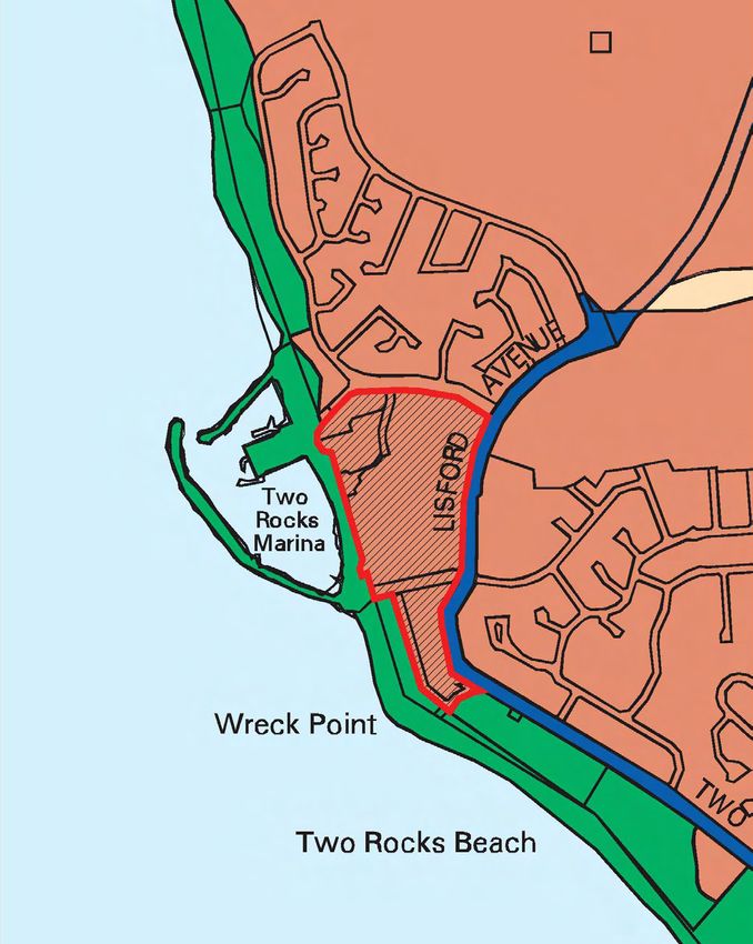
PART ONE:
STATUTORY PROVISIONS
Record of Amendments made to the Agreed Structure Plan

Amendment No.    Description of Amendment           WAPC Adopted         Council Adopted
ŒŒ FIGURE 1 (STATUTORY PROVISIONS) TWO ROCKS TOWN CENTRE LOCAL STRUCTURE PLAN
sovereign drive
Potential re-development of
Atlantis Village Shopping
Centre by others
t
ee Lot 801
str
pe Lot 50
po Precinct A :
E
UT
Dolphin Island
avenue
RO
Lot 800
R20 - R60
R
drainage
DE
se
FEE
Lot 50 enterpri
BUS
Lot 50
Precinct B :
The King opportunity to retain
R40 - R80 mature exotic vegetation
associated with previous
use of the site (Atlantis
Lot 10 Marine Park).
3OOm
avenue
existing Precinct D :
Potential re-development of The Wall
marina tavern site by others Lot 100
R80 - R160
king neptune
to be retained
t
Lot 50 stree future connection to
street/pedestrian-cycle
main link to residential area /
possible future signalised
Precinct C :
BUS FEEDER ROUTE
Lot 50 intersection
Exact location of path on sea plaza
wall to be determined at Main Street
DAP stage e
drainag R40 - R60
traffic signalisation
Lot 50 maybe required in the
medium / long term for
intersections on Lisford
Avenue (if upgraded to
dual carriageways).
lisford
Lot 50
Lot 50
drive charnwoo
lis d ave
austra
O Lot 1000
Precinct E :
Southern
R20 - R160
jordo
n
LEGEND
Structure Plan Boundary
Precinct Boundary
stree
ZONES
t
Commercial
Mixed Use t
ee
str
LOCAL SCHEME RESERVES on
m arc opportunity for a
Public Open Space mixed use building on
key gateway site
Landmark Site
Pedestrian Cycle Network
Shared Path
Lot Number Ownership
Existing Limestone Wall
50 Fini Group
District Distributor A
1000 Fini Group
District Distributor B
10 W & R Doherty, A & K Mavromatis,
M & A Weir
800 & 801 Carjon Holdings (WA) Pty Ltd,
Star Regent Pty Ltd, P & K O’Toole
100 State of Western Australia
TWO ROCKS TOWN CENTRE STRUCTURE PLAN
AFI TWR RD3 002B
8
1.0 APPLICATION                                                      2.0 OBJECTIVES

1.1 This Structure Plan applies to the Two Rocks townsite,           2.1 The objectives of this Structure Plan are to:
    being Lots 50, 800 + 801, 10 and Part Lot 1000 and
    consisting of all land contained within the inner edge               a)   Create a residential and mixed use, well defined town
    of the line denoting the Structure Plan boundary on the                   centre offering facilities of local and regional value.
    Structure Plan Map.                                                  b)   Provide a range of dwelling types and densities
                                                                              accommodating a diverse residential community.
1.2 Unless otherwise specified in this part, the words and               c)   Provide an open air ‘Main Street’ that creates the
    expressions used in this Structure Plan shall have the                    framework for mixed use, day and night activity,
    respective meanings given to them in the City of Wanneroo                 fostering a contemporary coastal community with
    District Planning Scheme No. 2 (the Scheme).                              boutique retail outlets.
                                                                         d)   Encourage tourism, ‘festive’ retail and entertainment
1.3 Pursuant to clauses 9.8.2 and 9.8.3 of District Planning                  uses, in particular in Precincts C (Main Street)
    Scheme No. 2, the provisions of this part shall apply to                  and D (The Wall).
    land contained within the Two Rocks Town Centre Local                e)   Provide for a transition of land use over time, including
    Structure Plan as follows:                                                robust and durable building design to accommodate
                                                                              change in future use.
    a)   the objectives, standards and requirements applicable           f)   Carefully locate streets, development sites and open
         to zones and R-codings under the Scheme shall apply                  spaces to maximise views to the marina and beyond.
         to the same extent to the areas having corresponding            g)   Improve linkages with the marina and adjacent
         designations under the Structure Plan, unless specific               existing development for maximum integration.
         provision is made to the contrary in this part.                 h)   Provide a highly interconnected street system and
                                                                              pathway network, enabling residents and visitors the
    b)   any other provision, standard or requirement of this                 real choice of being able to walk and cycle to facilities
         part that is not otherwise contained in the Scheme,                  and services.
         shall apply to the land as though it is incorporated into       i)   Encourage authentic and practical sustainable
         the Scheme, and shall be binding and enforceable to                  development initiatives.
         the same extent as if part of the Scheme;                       j)   Provide for the sensitive incorporation of cultural
                                                                              heritage elements.
    c)   Part 2 of this Structure Plan is for explanatory
         purposes only, to provide a descriptive analysis of the
         Structure Plan.                                             3.0 SUBDIVISIONS AND DEVELOPMENT

1.4 In accordance with clause 9.8.1 of the Scheme, this Structure    Tables 1 - 9 form part of the statutory provisions of this Structure
    Plan shall come into operation when it is certified by the       Plan and prescribe the standards, requirements and prerequisites
    Western Australian Planning Commission (WAPC) pursuant           for subdivision and development in the corresponding precincts
    to clause 9.6.3 (b) of the Scheme.                               designated on the Structure Plan Map. Where any variation
                                                                     arises between any provision of these Tables and a provision of
1.5 This Structure Plan may require review and amendment to          the Scheme, then the provision of the Table shall prevail to the
    reflect any amendments to the Yanchep-Two Rocks District         extent of that variation and shall apply as an intended variation
    Structure Plan made pursuant to Part 1, Clause 10 of the         to the Scheme for the purposes of Clause 9.8.3 (f ).
    District Structure Plan.
                                                                      Table 1 – General Planning Requirements for
                                                                          Local Structure Plan Area
                                                                      Table 2 - Planning Requirements for Precinct A: Dolphin Island
                                                                      Table 3 - Planning Requirements for Precinct B: The King
                                                                      Table 4 - Planning Requirements for Precinct C: Main Street
                                                                      Table 5 - Planning Requirements for Precinct D: The Wall
                                                                      Table 6 - Planning Requirements for Precinct E: Southern
                                                                      Table 7 - Car Parking Provision
                                                                      Table 8 - Commercial and Retail Floorspace Allocation
                                                                           for the Local Structure Plan Area
                                                                      Table 9 - Strategies and Plans

                                                                                                                                      9
Table 1 – General Planning Requirements for Local Structure Plan Area
 1. Residential Density   1.1 Residential design codes shall be in accordance with the ranges shown on the Structure Plan Map, and are to be
    Code Plan                 located in accordance with the following:

                                       a) Precinct A: Dolphin Island
                                       Residential density coding of between R20 - R60. The higher densities should be located close to
                                       Dolphin Island and Enterprise Avenue, and the lower densities should be located along Lisford
                                       Avenue and Sovereign Drive.

                                       b) Precinct B: The King
                                       Residential density coding of between R40 - R80. The higher densities should be located within the
                                       Commercial Zone and the lower densities should be located within the Mixed Use Zone.

                                       c) Precinct C: Main Street
                                       Residential density coding of between R40 - R60. The higher densities should be located along
                                       Lisford Avenue and close to the marina and the lower densities elsewhere.

                                       d) Precinct D: The Wall
                                       Residential density coding of between R80 - R160. The higher densities should be provided close to
                                       the marina and the lower densities elsewhere.

                                       e) Precinct E: Southern
                                       Residential density coding of between R20 - R30 in the Mixed Use Zone and R160 in
                                       the Commercial Zone.

                          1.2 Subdivision and development within the Structure Plan area shall be in accordance with a Residential Design Code
                              Plan endorsed by the WAPC.

                          1.3 A Residential Design Code Plan (three copies) shall be lodged with the WAPC for its endorsement in conjunction with
                              any application for subdivision, unless the WAPC determines that the subdivision is for one or more of the following:

                               1.3.1        The amalgamation of lots or part lots;
                               1.3.2        The consolidation of land for “superlot” purposes to facilitate land assembly for future development;
                               1.3.3        The purpose of allowing access; and/or
                               1.3.4        The facilitation and provision of services or infrastructure.

                          1.4 A Residential Design Code Plan shall show the specific Residential Design Coding of all lots proposed to be created by
                              a subdivision, in accordance with the Clause 1.1 of this Table.

                          1.5 Following WAPC endorsement of the Residential Design Code Plan, the Residential Design Code Plan shall become
                              part of Part 1 of this Structure Plan; one copy shall be retained by the WAPC, one copy shall be provided to the City for
                              retention with the Structure Plan, and one copy shall be provided to the proponent.

10
2. Detailed Area Plans 2.1 The City will not approve development within a Precinct in the absence of a precinct Detailed Area
Plan (DAP), approved by the City pursuant to clause 9.14 of the Scheme, for the whole of each
Precinct A-E, unless the City is satisfied that the development is of a scale and permanence that
would not prejudice the: design of the DAP; timely provision of infrastructure and services to the
area; or the development of the surrounding area in line with the Agreed Structure Plan.
2.2 The City will not accept a precinct DAP for any area that is geographically smaller than a Precinct,
as illustrated on the Structure Plan Map.
2.3 A DAP for a Precinct shall be advertised for a period of 28 days prior to its consideration under
Clause 9.14.3 of the Scheme.
2.4 In addition to any general matters required to be included within a DAP under Clause 9.14.2 of the
Scheme, and the specific matters required to be included in each precinct DAP under Tables 2 – 8,
all precinct DAPs shall incorporate provisions and design elements addressing the following:
Road network generally in accordance with Appendix 2 Traffic and Transport Report, and
connecting with the Road Network shown on the Structure Plan Map:
a. ) Pathways and Cycleways generally in accordance with Figure 20.
b. ) On Street Parking, generally in accordance with the Figure 21.
c. ) Average maximum building front setbacks, footprints and/or envelopes.
d. ) Distribution of commercial and retail floorspace allocated for the Local Structure Plan area in Table 8 of
Part One.
e. ) Public Open Space located generally in accordance with the Structure Plan Map. (Refer to point 4.1
regarding Public Open Space provision.)
f. ) Any vegetation identified for retention.
g. ) Levels and retaining walls.
h. ) Private and public car parking in accordance with the ratios identified in Table 7 of Part One.
i. ) Car parks designed to provide good pedestrian movements towards buildings whilst minimising their
visual impact on the amenity of the street.
j. ) Dedicated car parking areas unobtrusively located and not dominating the streetscape. Expansive car
parking areas should be sleeved behind buildings, screened from prominent communal spaces and
accessed via laneways.
k. ) Buildings designed to address all street and public open space frontages, and not include blank facades
on these frontages.
l. ) Entries to buildings, pedestrian walkways and car parking areas, clearly defined as elements at the street
frontage.
m. ) Upper levels of buildings designed to ensure rear laneways can be surveyed from within the dwelling.
n. ) Upper level residential dwellings with a balcony located on the primary street frontage, with defined
minimum dimensions.
o. ) North facing walls with a maximised window area and external measures such as solar awnings/louvres
and planting to provide shade in summer months and provide direct sunlight access in winter months.
p. ) East and west facing walls with external shading measures such as verandahs, balconies, awnings, louvres
and/or trees.
q. ) Privacy measures not compromising the provision of good surveillance to streets, lanes, pedestrian access
ways and public open space.
r. ) Signage integrated with buildings and appropriate in character.
s. ) Acoustic attenuation measures incorporated into building design to manage the mix of residential and
non-residential uses, including appropriate attenuation measures in dwellings and measures to minimise
the escape of noise from non-residential premises.
t. ) Linkage of all POS areas across the site, including to Charnwood Reserve and Coastal Foreshore Reserves.
u. ) View corridors of the ocean and The King from existing residential areas, Charnwood Reserve and the
Marina, generally in accordance with the view corridors shown on the Site DNA map.
v. ) The retention of the Waugul Monolithic collection in its entirety and an appropriate configuration within
the Structure Plan area.
w. ) Wind direction.
x. ) Contaminated sites.
y. ) The operation of the marina and associated activities.
113. Reports, Surveys, 3.1 Prior to any subdivision or development being supported, the City will require:
Strategies and Plans i. ) The preparation and approval of the reports, surveys, strategies and plans listed in Table 9 of Part One at the
stage specified in that table; and
ii. ) A report accompanying any application for subdivision or development that outlines the manner in
which the findings and recommendations of the plans and strategies listed in Table 9 of Part One, will be
incorporated into or addressed by the proposed subdivision or development.
4. Public Open Space 4.1 A total of ten per cent of the gross subdivisible area shall be provided as Public Open Space, either as a ten
per cent land component, or eight per cent as land area and two per cent as a cash in lieu provision for the
development of Public Open Space in the Structure Plan area, subject to the approval of the Western Australian
Planning Commission and the Minister for Planning.
Table 2 – Planning Requirements for Precinct A: Dolphin Island
1. Detailed Area Plan 1.1 In addition to any general matters required to be included within a DAP (under Table 1 of this Structure
Plan) and Clause 9.14.2 of the Scheme, a DAP for Precinct A shall incorporate provisions and design
elements addressing the following:
a. ) Maximum building heights in accordance with State Planning Policy 2.6, State Coastal Planning Policy,
measured from finished lot levels as identified on the DAP.
b. ) Residential density coding of between R20 - R60 and a minimum dwelling yield.
c. ) Dolphin Pool incorporated into Public Open Space, generally in accordance with the Structure Plan Map.
d. ) The opportunity to retain significant vegetation where possible as a part of the Dolphin Pool Public Open
Space area in accordance with the Structure Plan Map.
2. Land Use 2.1 Land Use permissibility within Precinct B shall be in accordance with the corresponding
Permissibility Zone or Reserve under the Scheme, except as follows:
Zone Use Classes Mixed Use
Aged or Dependent Person’s Dwelling P
Ancillary Accomodation D
Art Gallery P
Caretaker’s Dwelling P
Dry Cleaning Premises D
Hire Service D
Retirement Village P
Single House P
Video Hire D
12Table 3 – Planning Requirements for Precinct B: The King
1. Detailed Area Plan 1.1 In addition to any general matters required to be included within a DAP (under Table 1 of this
Structure Plan) and Clause 9.14.2 of the Scheme, a DAP for Precinct B shall incorporate provisions
and design elements addressing the following:
a. ) Maximum building heights in accordance with State Planning Policy 2.6, State Coastal Planning Policy,
measured from finished lot levels as identified on the DAP.
b. ) As a guide only, a target yield of 60 dwellings.
c. ) The King Neptune sculpture incorporated into public open space, generally in accordance with the
Structure Plan Map.
d. ) In the Commercial Zone, building elements, including attachments such as verandahs or awnings,
average maximum setbacks of 3 metres from the street boundary and nil side setbacks.
e. ) In the Commercial Zone, commercial and retail uses that create pedestrian interest and activity, or
dwellings that can later be adapted for commercial and retail uses, are encouraged at ground level.
f. ) A layout that retains the potential to create vista/view lines of King Neptune from within the Town Centre
and from surrounding residential areas.
g. ) Development highlighting and complimenting King Neptune as a Landmark element of the
Two Rocks area.
h. ) Commercial and retail floor space allocation in accordance with Table 8.
2. Land Use 2.1 Land Use permissibility within Precinct B shall be in accordance with the corresponding Zone or
Permissibility Reserve under the Scheme, except as follows:
Zone Use Classes Mixed Use
Aged or Dependent Person’s Dwelling P
Ancillary Accomodation D
Art Gallery P
Dry Cleaning Premises D
Hire Service D
Retirement Village P
Video Hire D
Zone Use Classes Commercial Use
Aged or Dependent Person’s Dwelling P
Ancillary Accomodation D
Hire Service D
Market (Retail) P
Public Exhibition Facility P
Retirement Village P
13Table 4 – Planning Requirements for Precinct C: Main Street
1. Detailed Area Plan 1.1 In addition to any general matters required to be included within a DAP (under Table 1 of this
Structure Plan) and Clause 9.14.2 of the Scheme, a DAP for Precinct C shall incorporate provisions
and design elements addressing the following:
a) Maximum building heights in accordance with State Planning Policy 2.6, State Coastal Planning
Policy, measured from finished lot levels as identified on the DAP.
b) As a guide only, a target yield of 55 dwellings.
c) Public open space incorporating a drainage infiltration area, generally in accordance with the
Structure Plan Map.
d) Building elements, including attachments such as verandahs or awnings, average maximum
setbacks of 3 metres from the street boundary and nil side setbacks.
e) In the Commercial Zone, commercial and retail uses that create pedestrian interest and activity, or
dwellings that can later be adapted for commercial and retail uses, at ground level.
f) Commercial and retail floor space allocation in accordance with Table 8.
2. Land Use 2.1 Land Use permissibility within Precinct C shall be in accordance with the corresponding Zone or
Permissibility Reserve under the Scheme, except as follows:
Zone Use Classes Mixed Use
Ancillary Accomodation D
Art Gallery P
Convenience Store P
Dry Cleaning Premises D
Hire Service D
Public Exhibition Facility P
Shop P
Video Hire D
Zone Use Classes Commercial
Ancillary Accomodation D
Bakery P
Hire Service D
Public Exhibition Facility P
Market (Retail) P
14Table 5 – Planning Requirements for Precinct D: The Wall
1. Detailed Area Plan 1.1 In addition to any general matters required to be included within a DAP (under Table 1 of this
Structure Plan) and Clause 9.14.2 of the Scheme, a DAP for Precinct D shall incorporate provisions
and design elements that address the following:
a. ) Maximum building heights in accordance with State Planning Policy 2.6, State Coastal Planning Policy,
measured from finished lot levels as identified on the DAP.
b. ) As a guide only, a target yield of 320 dwellings.
c. ) Public Open Space incorporating a town plaza as the main connection between the Town Centre and the
marina and two local parks providing links to the marina, generally in accordance with the Structure Plan
Map.
d. ) Retention of the Two Rocks Limestone Retaining Wall heritage structure with any alterations to provide
breaks in the wall for linkages between Town Centre and marina.
e. ) Opportunities for the relocation and retention of the Waugul Monolith heritage items in its entirety and
an appropriate configuration within the SP area.
f. ) Opportunities for the retention and adaptive reuse of the Two Rocks Shopping Centre buildings.
g. ) The continued use of portion of Lot 50 for car parking and rights of carriageway for Lot 10 in accordance
with the deed of easement, or if the easement is extinguished, the alternative arrangements put in place
to address the access and parking issues associated with Lot 10.
h. ) Building elements, including attachments such as verandahs or awnings, average maximum setbacks of 3
metres from the street boundary and nil side setbacks.
i. ) In the Commercial Zone, commercial and retail uses that create pedestrian interest and activity, or
dwellings that can later be adapted for commercial and retail uses at ground level.
j. ) Commercial and retail floor space allocation in accordance with Table 8.
2. Land Use 2.1 Land Use permissibility within Precinct D shall be in accordance with the corresponding Zone or
Permissibility Reserve under the Scheme, except as follows:
Zone Use Classes Mixed Use
Ancillary Accomodation D
Art Gallery P
Dry Cleaning Premises D
Hire Service D
Public Exhibition Facility P
Video Hire D
Zone Use Classes Commercial
Ancillary Accomodation P
Bakery P
Cinema P
Hire Service D
Hotel P
Public Exhibition Facility P
Market (Retail) P
15Table 6 – Planning Requirements for Precinct E: Southern
1. Detailed Area Plan 1.1 In addition to any general matters required to be included within a DAP (under Table 1 of this
Structure Plan) and Clause 9.14.2 of the Scheme, a DAP for Precinct E shall specifically incorporate
the following provisions and design elements:
a. ) Maximum building heights in accordance with State Planning Policy 2.6, State Coastal Planning Policy,
measured from finished lot levels as identified on the DAP. Single storey buildings are permitted.
b. ) As a guide only, a target yield of 60 dwellings.
c. ) Built form that responds to the topography and landscape and a layout that retains the potential to create
vista/view lines across the site from within the Town Centre and from surrounding residential areas.
d. ) Development addressing Lisford Avenue.
e. ) Commercial and retail floor space allocation in accordance with Table 8.
2. Land Use 2.1 Land Use permissibility within Precinct E shall be in accordance with the corresponding Zone or Reserve under
Permissibility the Scheme, except as follows:
Zone Use Classes Mixed Use
Ancillary Accommodation P
Art Gallery P
Dry Cleaning Premises D
Hire Service D
Public Exhibition Facility P
Video Hire D
Zone Use Classes Commercial
Ancillary Accommodation D
Table 7 – Car Parking Provision
Land Use Car Parking Rate Ratio of Public to Private Car Parking
Retail 4.6 bays per 100m GLFA
2
25% public; 75% private
Office 1.9 bays per 100m2 GLFA 25% public; 75% private
Medical 3 bays per 100m GLFA
2
Visitor spaces to be provided on-street
Residential In accordance with the Residential Design
Codes, except that visitor spaces for grouped
and multiple dwellings are provided at a rate of
10% of the total per dwelling rate.
16Table 8 – Commercial and Retail Floorspace Allocation for the Local Structure Plan Area
Floorspace Minimum Net Lettable Area Floorspace Maximum Net Lettable Area Floorspace
Commercial, educational, 20% mix of land uses floorspace as a proportion of the
health, entertainment, leisure or total floorspace, to be demonstrated at Detailed Area Plan
community service and Development Application stage, in accordance with
State Planning Policy 4.2.
Retail 7,000 sqm
Note: The floorspaces allocation is based on the floorspace projections set out in the Yanchep-Two Rocks District Structure Plan (DSP),
and assumes that the expansion of the Two Rocks Marina will form the remainder of the Two Rocks District Activity Centre. In order to
achieve the overall employment self sufficiency target of 75% for the Yanchep-Two Rocks area, the employment projections for the
Two Rocks District Activity Centre set out in the DSP are intended to be met through the expansion of the Two Rocks Marina and the
inclusion of the remaining floorspace projected by the DSP, in this part of the centre.
Pursuant to subclause 3.7.4 of the Scheme, the maximum net lettable areas included in Table 8 may be exceeded through a DAP where
the requirements of State Planning Policy 4.2 Activity Centres for Perth and Peel are met to the satisfaction of the Western Australian
Planning Commission and the requirements of any relevant local planning policy are met to the satisfaction of the City of Wanneroo.
Table 9 – Reports, Surveys, Strategies and Plans
Documentation Submission Stage Approving Authority
Earthwork and In conjunction with Subdivision Application City of Wanneroo /
Contour Plan Western Australian Planning Commission
Acid Sulphate Soils In conjunction with Subdivision Application City of Wanneroo /
Investigation Western Australian Planning Commission
Acid Sulphate Soils Subdivision Clearance (only if required) City of Wanneroo
Management Plan
Street Tree In conjunction with Subdivision Clearance City of Wanneroo
Masterplan
Urban Water Subdivision Clearance City of Wanneroo /
Management Plan The Department of Water
Servicing Plan Subdivision Clearance City of Wanneroo /
Western Australian Planning Commission
Contaminated Site Subdivision Application (only if required) Department of Environment and Conservation
Investigations and
Remediation
Community Within first three years following City of Wannaroo
Development Plan the first subdivision
17PART TWO: EXPLANATORY TEXT
1 INTRODUCTION & BACKGROUND
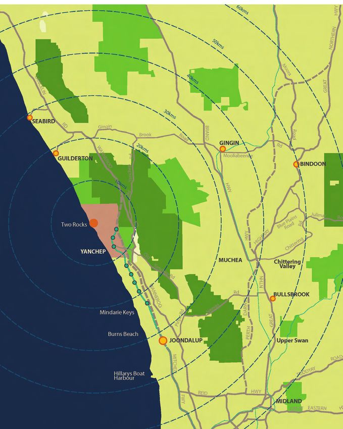
ŒŒ FIGURE 1: REGIONAL CONTEXT
Yanchep Two
Rocks DSP
Area
JINDEE
TWO ROCKS
ST ANDREWS
JOONDALUP
STIRLING
60kms 50kms 40kms 30kms 20kms PERTH
FREMANTLE
ROCKINGHAM
MANDURAH
201 INTRODUCTION | SITE DESCRIPTION
ŒŒ FIGURE 2: LOCAL CONTEXT
1.1 INTRODUCTION
This Structure Plan has been prepared to guide the development
of the Two Rocks Town Centre, which includes the existing sovereign drive
Atlantis Village and Two Rocks Shopping Centres, Two Rocks
enterprise ave
Tavern, Function Centre and Bottle Shop and land formerly 801
occupied by the Atlantis Marine Park. 800 50
As detailed in the table below, the Fini Group own the majority 10
of the Two Rocks Town Centre comprising Lot 50 and Part Lot
lisford avenue
1000. Lot 100, the existing Tavern and Function Centre (Lot 10) 50
100
and northern shopping centre (Lot 800 + 801) are not owned by
Fini Group.
The Structure Plan aims to create a vibrant and sustainable town
centre, comprising a mix of land uses and dwelling types centred
1000
on an open air ‘Main Street’. The Structure plan proposes a highly
interconnected street and path network, and improved linkages
to the adjacent marina and other surrounding development.
Part 1 of the Structure Plan report contains the statutory planning
provisions applicable to the Structure Plan area.
Part 2 of the Structure Plan report provides a descriptive
analysis of the Structure Plan, including site description, project
background, opportunities and constraints, the existing statutory The site is located approximately 57km north north-west of the
planning framework, a description of the Structure Plan and the Perth city centre and approximately 32km north north-west of
proposed implementation. the Joondalup city centre,
The site is situated within the Yanchep-Two Rocks District
1.2 SITE DESCRIPTION Structure Plan area, as discussed in section 2.4 of this report.
1.2.1 Location 1.2.2 Land Ownership
The subject land comprises the Two Rocks townsite and is • Lot 800 + 801 and Part Lot 1000 are owned by Fini Group
generally bounded by Sovereign Drive to the north, Lisford Pty Ltd.
Avenue to the east, Marcon Street to the south, and a high
limestone wall and Jordon Street to the west. • Lot 10 is owned by W and R Doherty, A and K Mavromatis,
and M and A Weir.
The land comprises Lots 50 and 1000 (Fini Group) – 17.1415ha • Lot 800 + 801 is owned by Carjon Holdings (WA) Pty Ltd,
and Lots 800, 801, 10 and 100 (others) – 1.4867ha for a total area Star Regent Pty Ltd, and P and K O’Toole.
of 18.6282ha.
• Lot 100 is owned by the State of Western Australia
ŒŒ TABLE 1: SUBJECT LAND
LOT NUMBER CERTIFICATE OF TITLE VOLUME / FOLIO AREA
Lot 50 Enterprise Drive 1892 / 740 14.5034ha FINI GROUP
Part Lot 1000 Lisford Avenue 2020 / 886 2.6381ha
Lot 10 1957/267 2864m²
Lot 800 Pope Street 2687/805 5051m2
OTHERS
Lot 801 Soverign Drive 2687/806 6370m2
Lot 100 1685/950 583m2
TOTAL 18.6282ha
211 INTRODUCTION & BACKGROUND
ŒŒ FIGURE 3: LAND OWNERSHIP
Lot 801
Lot 800
Lot 50
Lot 10
Lot 50
Lot 100
5
Lot 1000
221 SITE DESCRIPTION | PROJECT BACKGROUND
As stated above, the Fini Group does not own the existing Two with emphasis on public life.
Rocks Tavern, Function Centre and Bottle Shop site (Lots 10 and 1.3.2 Enquiry by Design Workshop
100) or the existing Atlantis Village shopping centre (Lots 800 +
801). To present a co-ordinated structure plan, these sites have The Enquiry by Design Workshop that was held to progress the
been included in the development concepts for the Two Rocks planning of the Two Rocks Town Centre and which included
Town Centre. representation from the City of Wanneroo and the Department
for Planning and Infrastructure (DPI) established a design
framework for the future development of a compact town centre
1.2.3 Existing Land Use & Development development. It envisaged a multi-functional centre comprising
a main street, a business strip, a range of residential housing at
Lot 50 contains the existing Two Rocks Shopping Centre densities, intimate open spaces, among other elements.
and associated car parking, King Neptune statue, Waugul
monoliths and a waste water treatment plant. The Atlantis The report that culminated from this workshop observed
Marine Park previously occupied the eastern portion of Lot that although the town centre land occupies a good vantage
50. Part Lot 1000 is currently vacant, apart from leach drains point, “visitors to the current town centre have very limited
that extend into the northern portion of the Lot. Lot 10 is access to the harbour waterfront.
occupied by the Two Rocks Tavern, Function Centre and
Bottle Shop. Lot 100 largely contains the limestone wall. As a result, the opportunities for developing a relationship
The Tavern, Function Centre and Bottle Shop is permitted to park between the town centre and the harbour are limited.”
vehicles on Lot 50 through a deed of easement arrangement. Recognising this issue, the report indicated that “Ideally the Main
Lots 800 + 801 are occupied by the Atlantis Village shopping Street would grade down in a gentle slope from Lisford Avenue
centre. to the harbour’s edge, and terminate in a T-junction with the
harbour esplanade road.”
1.3 PROJECT BACKGROUND It should be noted that the design workshop failed to recognise
a number of constraints in relation to the site, these being;
1.3.1 Project Team
• The townsite land is under the control of different owners;
In 1999, the Fini Group purchased the Two Rocks Town Centre,
• The existing limestone retaining wall is heritage listed by
comprising the shopping centre and the former Atlantis Marina
the City of Wanneroo precluding the construction of a
Park site. In late 2004 the Fini Group appointed a multi-disciplinary
vehicle access to the marina;
project team, as listed below, to progress the preparation of a
structure plan for the Two Rocks Townsite.
• A large footprint retail site is located on ‘Dolphin Island’
which has been identified as a feature to retain which
• Sharni Howe Architects reflects the previous uses of the land by the Atlantis
• Roberts Day Town Planning + Design Marine Park.
• Sinclair Knight
• Phillip Griffiths Architects As part of the Structure Plan design process, the project team
has reviewed the plan prepared through the ‘Enquiry by Design
• Creating Communities Workshop’ and identified obvious improvements, i.e.;
• RPS – Environmental Management Consultants
• Need to retain the Limestone Retaining Wall and King
• Generation Projects Neptune as outlined in the City of Wanneroo Municipal
Heritage Inventory Review;
The objective that the Fini Group holds for the Two Rocks Town
Centre is to create a vibrant, mixed use centre that is accessible • Incorporate an amount of retail / commercial floor space
and open beyond normal business hours. in accordance with the Yanchep - Tow Rocks District
Structure Plan allocations in relation to the hierarchy
of centres;
It is envisaged the Town Centre will include a commercially
sustainable permutation of medium density housing, retailing, • A main street alignment that is centrally located in the
commercial, entertainment and community uses. In order to catchment, retains King Neptune and provides a direct
deliver this urban environment, Two Rocks has the potential to connection to a pedestrian access in the retaining wall.
This will result in an important linkage to the Marina.
incorporate a ‘Main Street’ comprising a high quality streetscape
231 INTRODUCTION & BACKGROUND
ŒŒ FIGURE 4: EXISTING LAND USE AND DEVELOPMENT
vereign dve
ve
enter prise a
nue
d ave
lisfor
charnwo
od ave
mixed use
residential
open space
community
marina
future urban
241 PROJECT BACKGROUND
1.3.3 Community Consultation (Initial Phase)
The Fini Group in association with Creating Communities The project team consulted the following Government Agencies
Australia undertook an initial phase of community consultation during the preparation of the Structure Plan;
with the residents of Two Rocks located directly adjacent the •• Department for Planning and Infrastructure
landholding on; Lisford Avenue, Charnwood Avenue and (Planning and Maritime Sections);
Springhill Place. One on one consultations were conducted with
• Department for Environment and Conservation,
those homeowners who were available or willing to participate.
• Heritage Council,
Overall the majority of residents accepted that future growth for • Water Corporation,
the area was inevitable and were eager to have input into the • Western Power,
potential plans. While the majority of residents interviewed were • City of Wanneroo.
optimistic that the redevelopment would ultimately add value to
their property and lifestyle, a small number of those interviewed The project team has also consulted with the proponents
were ardently opposed to the redevelopment. of structure plans for surrounding landholdings to ensure
appropriate linkages between the projects.
Despite this small contingent, a number of positive suggestions
were raised. The feedback from the above consultation has been incorporated
into the proposed Structure Plan design.
The main themes included:
• A strong desire to retain the King Neptune statue in its
current location ; 1.3.4 Objectives
• The need for Two Rocks to retain much of its current relaxed
coastal lifestyle ; The principle objective of this document is to provide a sound
• The need to include strict design guidelines to maintain the planning basis for the future subdivision and development of
current aesthetics of the town ; land within the Structure Plan area. More specifically, the aims
and objectives of the Structure Plan are as follows;
• That building heights do not extend beyond two storeys in front
of current residential properties ;
• Establish a clear development vision for the Two Rocks
• The inclusion of additional shops, cafes, boutiques, medical
townsite;
facilities and other recreational facilities in the upgrade of the
• Create a mixed use, well defined town centre offering
commercial town centre ;
facilities of local and regional value;
• To retain as much of the natural vegetation as possible in the form
• Provide an open air ‘Main Street’ that creates the
of a green belt or buffer along Lisford avenue ;
framework for mixed use, day/night activity;
• To include adequate open space and parklands, with provision for
• A range of dwelling types and densities accommodating a
children’s play areas , barbeque and picnic facilities; and
diverse residential community;
• Better public transport routes to and from major external
• Streets, development sites and open spaces carefully
shopping districts ;
located to maximise views to the marina and beyond;
• Linkages with the marina and adjacent existing
The most pressing concerns highlighted during the
development for maximum integration;
consultation included ;
• A highly interconnected street system and pathway
• Current sewage and waste management in the
network, enabling residents and visitors the real choice of
Two Rocks area ;
being able to walk/cycle to facilities and services;
• Traffic issues along Lisford Avenue due to the “S bend” located
• Authentic and practical sustainable development
directly in front of residents properties. Also the residents raised
initiatives;
concern about increased traffic / lots egress on the southern
• Sensitive incorporation of cultural heritage elements; and
section of Lisford Avenue ;
• Address the requirements of the City of Wanneroo District
• View (ocean and marina) corridors across the southern precinct
Planning Scheme No. 2.
for affected landowners (in Lisford Avenue and Springhill Place)
• Retaining walls or houses backing onto Lisford Avenue; and
• Traffic on Lisford Avenue, and options such as a dual carriageway
restricting directional access and roundabout controls.
252 CONTEXTUAL ANALYSIS / EXISTING STATUTORY FRAMEWORK
ŒŒ FIGURE 5: METROPOLITAN REGION SCHEME
SUBJECT SITE
262 CONTEXTUAL ANALYSIS / EXISTING STATUTORY FRAMEWORK
2.1 METROPOLITAN REGION SCHEME 2.3 STATE STRATEGIES & POLICIES
The whole of the Two Rocks Townsite Local Structure Plan area 2.3.1 State Sustainability Strategy
is zoned ‘Urban’ under the Metropolitan Region Scheme (MRS).
The adjacent foreshore and marina are reserved for ‘Parks and The State Sustainability Strategy provides an overarching
Recreation’ purposes under the MRS. Lisford Avenue is reserved framework for the State Government to respond to the
as an MRS ‘Other Regional Road’. sustainability agenda. The Strategy identifies the following six
broad goals and 42 strategy areas intended to fulfil these goals
The Yanchep-Two Rocks District Structure Plan identifies the and to guide Government action towards achieving its vision for
proposed lifting of the MRS reservation from Lisford Avenue. This a sustainable Western Australia:
will be the subject of a future MRS Amendment.
• Sustainability and governance
The land is subject to resolution number 63 under Clause • Contributing to global sustainability
32 of the Metropolitan Region Town Planning Scheme Act - • Sustainable natural resource management
Coastal Buildings Above Specific Heights. This requires that • Sustainability and settlements
applications for buildings exceeding five storeys (21m) in height, • Sustainability and community
or eight storeys (32m) in height where permissible in the local • Sustainability and business
planning scheme, on land within 300m of the horizontal setback
datum as defined in State Planning Policy No. 2.6, are referred The policy objectives of the State Sustainability Strategy are
to the Western Australian Planning Commission (WAPC) for incorporated into the planning system through State and Local
determination. Government policy and formally applied through planning
decisions. The role of sustainability – economic, environmental
and social - is fundamental to the planning of the Two Rocks
2.2 CITY OF WANNEROO DISTRICT PLANNING Town Centre and is implicitly embodied in the content of this
SCHEME NO. 2 Local Structure Plan.
The site is zoned ‘Marina’ under the City of Wanneroo District
Planning Scheme No. 2 (DPS 2). 2.3.2 State Planning Strategy
Clause 3.10.1 of DPS 2 states that “the Marina Zone is intended to The State Planning Strategy (1997) was prepared by the WAPC
accommodate a wide range of appropriate development adjacent as a whole of Government approach to guide sustainable land
to marinas.” Pursuant to Clause 3.10.2, the objectives of the use planning throughout the State up until 2029. The Strategy
Marina Zone are to: is aimed at developing a land use planning system to help the
State achieve a number of key goals. These include generating
( a. ) accommodate commercial, residential, recreational and wealth, conserving and enhancing the environment and
associated activities related to marinas;
building vibrant and safe communities for the enjoyment of
( b. ) guide and manage the planning and development of areas
adjacent to marinas to ensure a diverse mix of uses and high this and subsequent generations of Western Australians. The
standards of amenity.” Strategy was last audited in 2000-2001. The Local Structure Plan
for the Two Rocks Town Centre is consistent with the goals and
Under Clause 3.10.3 of DPS 2, an Agreed Structure Plan must objectives of the State Planning Strategy.
be prepared and adopted under Section 9 of DPS 2 prior to the
commencement of any subdivision or development within the
Marina Zone. The Local Structure Plan for the Two Rocks Town
Centre has been prepared to fulfil the requirements of Clause
3.10.3 of DPS 2.
The King Neptune Sculpture and Two Rocks Limestone Retaining
Wall are included in the Heritage List prepared pursuant to Clause
5.2 of DPS 2. The Heritage List identifies places considered to be
of cultural heritage significance and worthy of conservation.
272 CONTEXTUAL ANALYSIS / EXISTING STATUTORY FRAMEWORK
ŒŒ FIGURE 6: CITY OF WANNEROO DISTRICT PLANNING SCHEME NO. 2
R
AG
ATE
GAL
V
EC2
W
EA
CT
TH
TE
L
ER L
GR E
R20
EY
CT
K
DR
C
RO
CT
M
A
SH
I N T R E P ID
PO
PE S T
WY
ENT E
T LE
IS
TH
R P R IS E
Y
AV E
W
R
GE
CHESTER AVE
RA N
BOWER GR
ASCHE WY
E
AV
D
DA W Y
OO
C A S S IL
NW
AR
CH
EM CARFAX PL
BA
DA
T H E Y DO N G R
PL
INE
R20
S
ST
G
H ILL
P R IN
JORD
PL
S
AN S
STU
T
A
RT
PL
ST
ON
GR
RC
T
A
NS
T
ES
M
DE
RR
CT
GA
FIN
W
GE HI
FO
S T ON
ST TF
IEL
D
DR
PR E
CT
TT
HU
PL
ON
IL S
W
R20
XL
B LA
M
282 CONTEXTUAL ANALYSIS / EXISTING STATUTORY FRAMEWORK
2.3.3 Directions 2031 and Beyond
Directions 2031 and Beyond was released by the WAPC in The Two Rocks Town Centre Structure Plan addresses the
August 2010 as a high level spatial framework and strategic plan objectives of the Sub-Regional Strategy by providing for the
that sets a vision for the future growth of the Perth and Peel development of a mixed use activity centre that will contribute
region. The plan details the metropolitan structure, identifies to meeting housing and employment targets.
local population housing and job targets, manages growth and
develops the activity centre concept.
2.3.5 Liveable Neighbourhoods
The plan identifies the following five strategic themes
and objectives: Liveable Neighbourhoods Edition 3 (LN 3) was prepared by
the WAPC to implement the objectives of the State Planning
• Liveable: living in, or visiting our city should be a safe, Strategy and deliver the strategies and actions of Network City.
comfortable and enjoyable experience. Unlike Edition 2 of LN, which is a voluntary code under which
• Prosperous: our success as a global city will depend on applications may be lodged and assessed, LN 3 has recently
building on our current prosperity. become a compulsory design code.
• Accessible: all people should be able to easily meet their
education, employment, recreation, service and consumer As an operational policy of the WAPC LN3 guides the design
needs within a reasonable distance of their home. and assessment of structure plans (regional, district and local),
• Sustainable: we should grow within the constraints placed subdivision and development for new urban areas. Its aims
on us by the environment we live in. include promoting the design of walkable neighbourhoods;
• Responsible: we have a responsibility to manage urban places that offer community and a sense of place; mixed uses and
growth and make the most efficient use of available land active streets; accessible and sustainable parks; energy efficient
and infrastructure. design; and a variety of lot sizes and housing types.
Directions 2031 and Beyond sets the following infill and The key initiatives of LN 3 are covered under eight design
greenfield housing targets: Elements. The implementation of each of these elements and
the fulfilment of the overall principles of LN will be fundamental
• An additional 328,000 houses to accommodate future growth. to ensuring that development of the Two Rocks Town Centre
• 47 per cent of the required dwellings as infill development. and the wider metropolitan region occurs in a thoughtful and
• 15 dwellings per gross urban zoned hectare of land in new sustainable manner.
development areas.
Application of the LN principles is therefore relevant to all levels
The Two Rocks Town Centre Structure Plan addresses the of planning for the Two Rocks Town Centre, from local structure
objectives of Directions 2031 and Beyond listed above through planning through to detailed lot and building design.
an ‘urban’ form of development.
2.3.6 North West Corridor Structure Plan
2.3.4 Outer Metropolitan Perth and Peel
Sub-Regional Strategy The North West Corridor Structure Plan ( NWCSP ) provides the
regional strategic planning framework for the development of
In August 2010, the WAPC also released draft sub-regional Perth’s North West corridor. The framework materialized from
strategies to provide further guidance for delivering the Metroplan and the Urban Expansion Policy.
objectives of Directions 2031 and Beyond. The Two Rocks
Town Centre Structure Plan area is included in the north-west The Yanchep area was excluded from the overall Structure Plan
metropolitan sub-region and is identified as Urban zoned at the request of Tokyu Corporation who commissioned Feilman
undeveloped land. Under the ‘connected city’ strategic growth Planning Consultants to prepare a separate study, the Yanchep
scenario, the population of the north-west metropolitan sub- Structure Plan that was completed in 1993 and included as an
region is estimated to grow by 39 per cent to 395,000 by 2031 addendum to the NWCSP. The existing MRS zoning reflects the
and an additional 69,000 jobs will be required to achieve 60 per outcomes of this plan.
cent employment self-sufficiency.
292 CONTEXTUAL ANALYSIS / EXISTING STATUTORY FRAMEWORK
It has been recognised that the NWCSP has not delivered the This SPP is supplemented by more detailed planning policies,
key economic, environmental and social outcomes, especially which provide specific guidelines for development and
relating to local employment generation, environmental protection of the environment and resources, including SPP No
sustainability and access to services and infrastructure. 2.6 Coastal Planning Policy, which is discussed below and has
The NWCSP is therefore currently being reviewed within the particular relevance to the Two Rocks Town Centre.
context of Network City and is scheduled to be advertised
in 2007.
SPP 2.6 – State Coastal Planning Policy
2.3.7 Statements of Planning Policy Statement of Planning Policy No. 2.6: State Coastal Planning
Policy was made under Section 5AA of the Town Planning and
Development of land must generally be consistent with any Development Act 1928.
relevant Statements of Planning Policy (SPP) prepared and
adopted by the WAPC under Section 5AA of the Town Planning The Policy applies to land use and development abutting the
and Development Act 1928. The WAPC and local governments coast, and contains setback requirements and building height
must have due regard to the provisions of SPPs when preparing limits. The objectives of the Policy are to:
or amending regional and district planning schemes and when
making decisions on planning matters. Details of the SPPs • protect, conserve and enhance coastal values, particularly
relevant to the Two Rocks Town Centre are provided below. in areas of landscape, nature conservation, indigenous and
cultural significance;
• provide for public foreshore areas and access to these on
SPP No 1 State Planning Framework the coast;
• ensure the identification of appropriate areas for the
The State Planning Framework unites existing State and regional sustainable use of the coast for housing, tourism,
policies, strategies and statements with a central framework to recreation, ocean access, maritime industry, commercial
provide a context for decision making on land use planning and and other activities; and
development matters in Western Australia. • ensure that the location of coastal facilities and
development takes into account coastal processes
The Two Rocks Town Centre project is consistent with the primary including erosion, accretion, storm surge, tides, wave
aim of this overarching policy, which can be surmised as “…to conditions, sea level change and biophysical criteria.
provide for the sustainable use and development of land.”
Sub-section 5.3 of the Policy sets a building height limit of five
The WAPC and local government will refer to the relevant storeys (21m) within 300m of the horizontal setback datum
planning instruments referred to under SPP No. 1 for all planning (as defined in the Policy). Buildings up to eight storeys (32m)
decisions, including those concerning the Local Structure Plan in height may be permitted in major tourist or activity nodes
and subsequent planning proposals presented for the Two Rocks where there is broad community support, it is consistent with
Town Centre. the character of the area, there is no significant overshadowing
of the foreshore, and visual permeability of the foreshore and
ocean from nearby areas is maintained.
SPP No. 2 Environment and Natural Resources Policy
The Two Rocks Town Centre Structure Plan responds to the
The Environment and Natural Resources SPP sets out a planning Coastal Policy by promoting development that achieves the
response to environment and natural resource management key objectives. The sea wall is retained and will become a key
issues within the framework of the State Planning Strategy. north–south public pedestrian linkage affording views of the
marina and coastline. Detailed Area Plans will identify maximum
Specific policy areas of relevance to the Two Rocks Town Centre building heights in accordance with the SPP 2.6.
include those relating to water resource management, air quality,
soil and land quality, biodiversity, marine resources, landscapes,
and greenhouse gas emissions and energy efficiency.
302 CONTEXTUAL ANALYSIS / EXISTING STATUTORY FRAMEWORK
SPP 2.8 - Bushland Policy for the Perth Metropolitan The Two Rocks Town Centre Local Structure Plan will facilitate:
Region
• excellent access to public transport, including the
SPP 2.8, which also sits under SPP No. 2 Environment and Natural provision of a dedicated transit corridor flanked by mixed
Resources Policy, has been prepared to give a statutory effect to use development extending through the centre of the
Bush Forever ( Government of Western Australia, 2000 ). entire study area and provision of a comprehensive
bus system;
Bush Forever identifies 51,200 ha of regionally significant • significant and wide-ranging employment opportunities
bushland for protection and covers 26 vegetation complexes on within activity centres, enterprise parks, industrial areas,
the Swan Coastal Plain of the Perth Metropolitan Region. One community centres, educational and recreational facilities;
of the key aims of Bush Forever is to conserve, where practical, • provision of quality and accessible local and regional
a target of at least 10 percent of each vegetation complex. recreation facilities, both active and passive;
The document outlines a framework for implementation as well • protection of significant environmental areas in
as individual recommendations for each of the 287 individual generous reservations;
Bush Forever Sites identified. • the creation of cohesive and walkable communities
through the application of traditional neighbourhood
Portion of Bush Forever site #397, the coastal strip from Wilbinga design principles; and
to Mindarie, is located adjacent to the Two Rocks Town Centre • a diversity of land uses, housing types and lot sizes.
Structure Plan area. This area is reserved in the MRS and is owned
by the State Government / Crown.
SPP 4.2: Activity Centres for Perth and Peel
The Two Rocks Town Centre Structure Plan allows for the
ongoing conservation and management of the adjacent Bush State Planning Policy No. 4.2: Activity Centres for Perth and
Forever area. Peel sets broad planning requirements for the planning and
development of new activity centres and the redevelopment of
existing activity centres.
SPP No 3: Urban Growth and Settlement
The Policy establishes a hierarchy of centres for Perth and Peel.
SPP No. 3, which was gazetted in February 2006, applies to the The Policy identifies a District Centre of up to 15,000m2 for Two
whole of the State in promoting sustainable and well planned Rocks. This District Centre corresponds to the Northern Town
settlement patterns that have regard to community needs and Centre identified in the Yanchep-Two Rocks District Structure
are responsive to environmental conditions. The objectives and Plan.
principles of Network City and Liveable Neighbourhoods are
enshrined in this Policy. The Yanchep-Two Rocks District Structure Plan includes a
hierarchy of activity centres, which identifies the Two Rocks Town
SPP No. 3 recognises that much new development in metropolitan Centre as a District Activity Centre with up to 11,000m2 of retail
Perth has been in the form of low density suburban growth. This floor space.
form of development intensifies pressure on valuable land and
water resources, imposes costs in the provision of infrastructure The Two Rocks Town Centre Structure Plan is consistent with the
and services, increases the dependence on private cars and Policy’s objectives of promoting a range of retail, commercial,
creates potential inequalities for those living in the outer suburbs community and residential development in activity centres.
where job opportunities and services are limited.
To promote growth that is sustainable, equitable and liveable,
SPP 3 encourages a more consolidated urban form. In general
terms the proposal for the Two Rocks Town Centre is consistent
with the high level principles of SPP3.
312 CONTEXTUAL ANALYSIS / EXISTING STATUTORY FRAMEWORK
2.4 CITY OF WANNEROO STRATEGIES & POLICIES
Smart Growth Economic Development Strategy
The City’s Smart Growth Strategy (SGS) recognises that its The City of Wanneroo’s primary economic goal is to decrease
population will continue to grow as a result of natural population the amount of people having to travel outside of the region
growth, immigration, regional population shifts and people’s to access suitable employment opportunities. Achievement
desires to live within the City. This growth needs to be managed by towards this goal is assisted through implementation of the
balancing economic, environmental and social principles. Smart City’s Economic Development Strategy.
Growth sets out to achieve this through the following principles:
The Economic Development Strategy is designed to build
• Lifestyle and housing choice - provision of a variety of upon the project initiatives already in place to introduce new
housing types and enhanced of lifestyle options; initiatives in line with the Strategic Plan. The Strategy accepts
that the promotion of the City as an investment and employment
• Effective use of land and infrastructure - effective use and destination demands participation from all relevant stakeholders.
development of land and buildings for the benefit of the The key actions of the City’s Economic Development Strategy are:
local area;
• Redressing the balance so that Wanneroo has desirable
• Long term health of the environment - development that centres of employment;
has minimum environmental impact and practices that • Investing for the future by increasing collaboration with
conserve and enhance natural areas; the State government and other key stakeholders to map
the strategic activities for the North West metropolitan
• Identity, equity and inclusiveness – growing the local economic region;
identities of the City’s places and its people;
• Generating wealth through jobs to create a new economic
base, which integrates the community into the wider
• Long term economic health - industry growth and job regional economy; and
creation within the region;
• Basic Infrastructure has to be in place to allow businesses
• People and government - citizen and stakeholder to prosper and grow.
participation in governance and development decisions.
The Local Structure Plan provides for the necessary infrastructure
These principles have guided the preparation of the Two Rocks and identifies appropriate areas for employment creation and an
Town Centre Local Structure Plan. The Smart Growth assessment urban fabric that is conducive to home-based business.
of the Local Structure Plan has been completed and is submitted
in Appendix 6 of this report.
Employment Policy
Local Environmental Strategy 2002 The City of Wanneroo’s Employment Policy is designed to
encourage and retain local employment within the City and
The City’s Local Environmental Strategy (LES) provides strategic ultimately the North West Corridor. The policy is driven by the
direction and focus for the City in its approach to conserve City’s low employment self-containment, which has resulted
the natural environment. The LES states that the capacity of a in many ‘dormitory suburbs’. The Policy contains a schedule
landscape to absorb a new activity needs to be determined prior to of strategies at district, local and subdivision level to indicate
development. The environmental assessment undertaken by the type and scale of initiatives expected for development of
ATA Environmental and submitted under Part 3 demonstrates that various scales.
the proposed DSP can be accommodated without compromising
the environmental and conservation values attributed to the As noted in section 4.5, the Two Rocks Town Centre Local
study area. Structure Plan exceeds the employment self-sufficiency target
for the North-West Corridor.
32You can also read