Lake Kipawa Concerted Management Plan First Progress Report: OBVT
←
→
Page content transcription
If your browser does not render page correctly, please read the page content below
Lake Kipawa Concerted Management Plan

                                First Progress Report:
                      Profile of territory, documented issues and concerns

                                              By

                                         Thibaut Petry

                         Organisme de bassin versant du Témiscamingue

Ville-Marie (QC), July 2013.

                                                                             1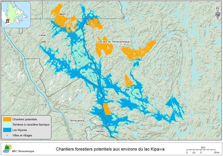
Table of Contents
List of Figures ............................................................................................... 4
List of tables................................................................................................. 4
Acknowledgements ..................................................................................... 5
Introduction ................................................................................................. 5
1. Methodology ........................................................................................... 6
   1.1      Profile of the Territory ..................................................................................................... 6
   1.2      Consultation and Joint Process ........................................................................................ 6
2. Profile of the Territory ............................................................................. 7
   2.1      Location and Description of Lake Kipawa ........................................................................ 7
         2.1.1     Location of Lake Kipawa ........................................................................................... 7
         2.1.2     Description of Lake Kipawa ...................................................................................... 7
   2.2      Land Allocation and Use................................................................................................... 9
         2.2.1     Land Allocation ......................................................................................................... 9
         2.2.2     Land Use ................................................................................................................... 9
         2.2.3     Zoning of the Riparian Buffer Strip......................................................................... 15
   2.3      Public Infrastructures ..................................................................................................... 15
   2.4      Recreation and Tourism Services and Companies ......................................................... 15
   2.5      Throughput .................................................................................................................... 17
   2.6      Existing Regulatory and Planning Tools ......................................................................... 18
         2.6.1     Regulatory Tools ..................................................................................................... 18
         2.6.2     Planning Tools ........................................................................................................ 20
   2.7      Lake Kipawa Water Quality and Level............................................................................ 20
         2.7.1     Water Quality ......................................................................................................... 20
         2.7.2     Water Levels ........................................................................................................... 23
   2.8      Habitats to be Protected and Sites of Interest .............................................................. 26
         2.8.1     Forest Habitats ....................................................................................................... 26
         2.8.2     Sites of Wildlife Interest ......................................................................................... 26
         2.8.3     Peatland ................................................................................................................. 26
         2.8.4     Sites of Archaeological Interest .............................................................................. 27
         2.8.5     Cultural Sites .......................................................................................................... 27
         2.8.6     Beaches .................................................................................................................. 27
   2.9      State of Plant Populations.............................................................................................. 27
   2.10 State of Faunal Populations ........................................................................................... 28

                                                                                                                                               2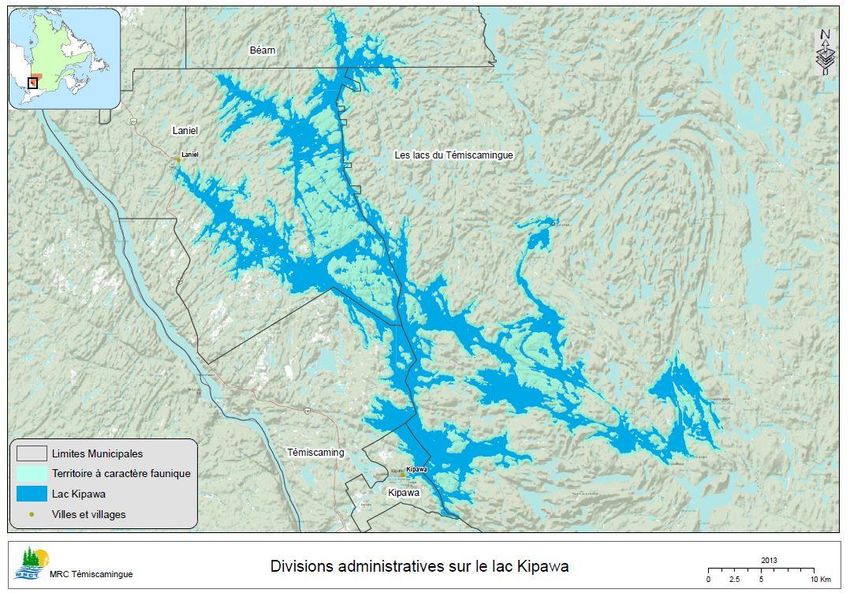
2.10.1 Birds ........................................................................................................................ 28
         2.10.2 Amphibians and Reptiles ........................................................................................ 28
         2.10.3 Fish Populations ..................................................................................................... 28
         2.10.4 Lake Trout Situation ............................................................................................... 28
         2.10.5 Yellow Walleye Situation ........................................................................................ 29
3. Individual Concerns................................................................................ 29
   3.1       Concerns ........................................................................................................................ 30
   3.2       Reasons for Refusing Development ............................................................................... 32
   3.3       Type of Development Considered ................................................................................. 33
   3.4       Problems to be Resolved before Developing................................................................. 35
4. Group Concerns ..................................................................................... 35
   4.1.      Municipalities ................................................................................................................. 35
   4.2.      Environmental and community sector .......................................................................... 36
   4.3.      Economic sector ............................................................................................................. 39
   4.4.      Aboriginal Communities................................................................................................. 40
5. Summary of Issues and Concerns ........................................................... 40
   5.1       Permanent and Temporary Residence .......................................................................... 40
         5.1.1      Documented Issues and Problems Raised ............................................................. 41
         5.1.2      Concerns ................................................................................................................. 42
   5.2       Fishing and Fish Stocks................................................................................................... 42
         5.2.1      Documented Issues and Problems Raised ............................................................. 42
         5.2.2      Concerns ................................................................................................................. 43
   5.3       Pleasure Boating and Use of Lake Kipawa ..................................................................... 43
         5.3.1      Documented Issues and Problems Raised ............................................................. 43
         5.3.2      Concerns ................................................................................................................. 43
   5.4       Commercial and Industrial Activities ............................................................................. 44
         5.4.1      Documented Issues and Problems Raised ............................................................. 44
         5.4.2      Concerns ................................................................................................................. 44
   5.5       Aboriginal Claims ........................................................................................................... 45
List of acronyms ......................................................................................... 46
Bibliography ............................................................................................... 47
   Articles and documents............................................................................................................ 47
   Online Resources ...................................................................................................................... 48
Appendices ................................................................................................ 49

                                                                                                                                               3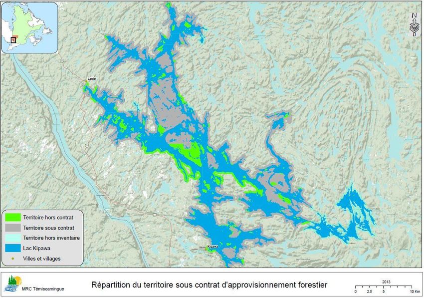
The following sections of the Lake Kipawa Concerted Management Plan will be put together in
the next two progress reports: the second one will contain the lake’s vocation as well as the
concerted development objectives, and the third one will contain the action plan and the zoning
plan.

List of Figures
Figure 1: Location of Lake Kipawa Watershed ................................................................................ 8
Figure 2: Administrative Divisions on Lake Kipawa ....................................................................... 10
Figure 3: Main Land Allocations in the Area of Wildlife Interest on Lake Kipawa ........................ 11
Figure 4: Protected Areas around Lake Kipawa ............................................................................ 12
Figure 5: Distribution of owners, lessees and occupants without permit or title on Lake Kipawa14
Figure 6: Zoning of the Riparian Buffer Strip ................................................................................. 16
Figure 7: Land Assignment for Forest Management Purposes ..................................................... 21
Figure 8: Potential Logging Areas up to 2018................................................................................ 22

List of tables
Table1: Anglers Throughput on Lake Kipawa from 1975 to 2006 ................................................. 18
Table 2: Summary of Requirements for Lake Kipawa Water Level ............................................... 24
Table 3: General Information on Water Level Management in Lake Kipawa ............................... 25
Table 4: Summary of Water Levels Controlled by CEHQ at Lake Kipawa ...................................... 25
Table 5: Floristic Species Likely to be Declared Endangered or Threatened in the Opémican
National Park ................................................................................................................................. 27
Table 6: Lake Trout Harvested in Lake Kipawa .............................................................................. 29
Table 7: Concerns Regarding Lake Kipawa .................................................................................... 32
Table 8: Reasons for Opposing Lake Kipawa’s Development........................................................ 33
Table 9: Type of Development Considered for Lake Kipawa......................................................... 35

                                                                                                                                                4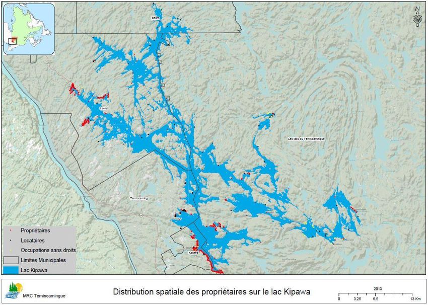
Acknowledgements
The MRC de Témiscamingue and the OBVT’s editing team wish to thank the people directly or
indirectly involved in the development of this document.
All the actors and citizens who contributed to the enrichment of the territory’s profile by sharing
their concerns, the Steering Committee members and the representatives of the Consultative
Committee have devoted valuable time to the project.
Thanks to a mobilisation of collective intelligence, Lake Kipawa will be managed in the best
possible way.

Introduction
Since the 1980’s, there is a moratorium on Lake Kipawa due to its exceptional features and the
precariousness of the wildlife populations. Initially, the moratorium imposed limits to the
outfitters’ accommodation capacity and was then applied to the whole development of
vacationing and cottages on public land. The lifting of the moratorium is made possible
following the drafting of a concerted development plan guided by a consultative committee. In
the present case, the document will be called the Lake Kipawa Concerted Management Plan as it
goes beyond a mere development planning process. For the administrative aspects, the Ministry
of Natural Resources will use the name of Concerted Development Plan.
The purpose of this first progress report is to identify and assess the lake’s specific
characteristics and existing problems as well as the concerns of the stakeholders and the public.
The main objective will then be, through the Concerted Management Plan, to maintain and
improve the quality of the water body by ensuring a long-term management. The lifting of the
moratorium is not a priority and it will be done conditional to the preservation of the resource.
Following the drafting of this profile, the objectives will be determined. Ultimately, an action
plan and measures will be proposed to ensure a sound management of the lake.
The project was initiated by the MRC de Témiscamingue who called upon the OBVT* to draft the
document and organise the consultation process. Partners such as the CRÉAT and MRN are
involved through a Steering Committee that sees to the proper functioning of the process
(keeping to allocated budgets, achieving the objectives, etc.).
Once the document is finalised, it will approved by the MRC de Témiscamingue and submitted
to the MRN which is the decision-making body.
The process objectives and description are detailed in the Project Plan in Appendix 1.

*: see the List of Acronyms at the end of the document.

                                                                                                 5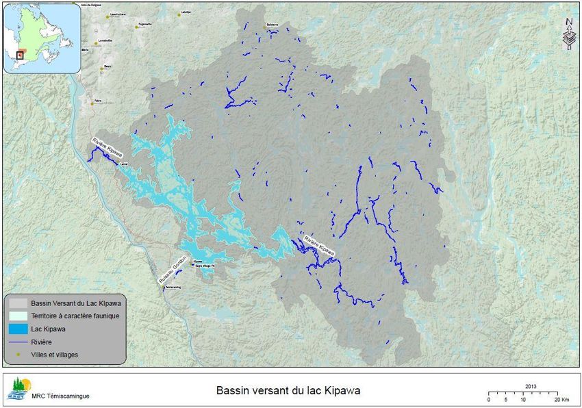
1. Methodology
1.1 Profile of the Territory
The following section is aimed at drawing a profile of the territory and presenting the
documented issues concerning Lake Kipawa; it is the result of a comprehensive literature
review, consultation with regional experts (MRN, MDDEFP, universities, MRC, municipalities,
etc.) and contributions from stakeholders and local population. In no case the raised issues
result from the authors’ personal reflections. The analysis was done based on the available
information; some information may have been omitted unintentionally and suggestions are
welcome.
In the consultation phase, it is of prime importance to take this information into account.

1.2 Consultation and Joint Process
In addition to the information obtained from the literature review and consultations with the
experts on the territory, the project managers wanted to involve as much as possible the
territory’s users and more generally the people interested in it.
The purpose of this second phase of the process is to clearly identify the actors’ and
stakeholders’ vision. The ultimate objective is to seek a form of development that respects the
quality of the environment.
Through continuous communication regarding the project, people who feel concerned can
participate. The public consultation workshops, the online survey and the petition were merged
to identify developmental concerns and intents.
At the same time, a Users Consultative Committee was formed to closely monitor the different
stages by providing opinions and enhancing the document (and to produce a document
consistent with the local reality).

The different planned stages of communication are as follows:
    - Press conference for the official launching of the project on March 27, 2013, releasing of
        the Project Plan;
    - Public consultation meeting on April 18;
    - Users Consultative Committee on the stakeholders’ and population’s concerns on June
        4;
    - Users Consultative Committee on the objectives and Lake Kipawa’s vocation on July 22;
    - Users Consultative Committee on the Action Plan and Zoning Plan in October;
    - Other meetings could be held if deemed necessary by the stakeholders and the public.

All these meetings will be summarised in a report and will also be made public, translated in
English and published on the OBVT website at: http://obvt.ca/activites/concertation.
Regular publications in local papers will also allow keeping the public informed.

Aboriginal communities located on the shores of Lake Kipawa have been met at the beginning of
the project to explain the process and ask them how they would like to take part in that process.
It is also the MRN’s mandate to officially and separately consult the Aboriginal communities.

                                                                                               6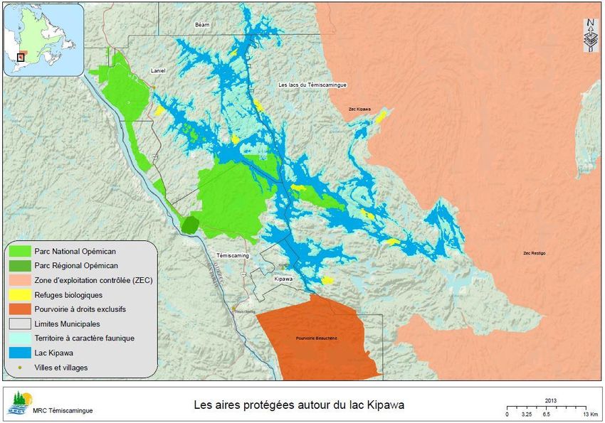
2. Profile of the Territory
The territory profile is divided into two main subsections:
- First, we will describe the territory and its human occupation.
- Secondly, we will describe the natural environment, flora and fauna.

2.1 Location and Description of Lake Kipawa
2.1.1 Location of Lake Kipawa
Lake Kipawa, with a surface area of 300.4 km², is located in the southwestern part of Abitibi-
Témiscamingue, bordering Ontario.

The territory considered in this document corresponds to the area of wildlife interest on which
the MRN has established a moratorium; it includes Lake Kipawa with a 300-metre riparian buffer
zone and the following lakes with the same buffer zone:
    -   Lake Desquerac                                   -   Lake Audoin
    -   Lake Grindstone                                  -   Lake Mungo
    -   Lake Hunter’s Point                              -   Lake Hunter
    -   Lake Mclachlin                                   -   Lake Bedout

The perimeter of this area of wildlife interest (length of shorelines) is 891.9 km. If we also take
into account the length of the islands’ shorelines, it adds up to a perimeter of 1513.4 km.

The total surface of the area of wildlife interest is 419 km² (MRCT, 2013). Nevertheless, we
cannot ignore the major problems observed on the whole watershed of a surface area of 6064
km² that extends from Belleterre in the north to the unorganised territory (TNO) of Les Lacs-du-
Témiscamingue in the east. See Figure 1: Location of Lake Kipawa Watershed

2.1.2 Description of Lake Kipawa
In Québec, there are 89 lakes of more than 100 km². About two thirds of them are found in
arctic Quebec (Nunavik) and are hardly accessible, contrary to the nine lakes in Abitibi-
Témiscamingue. These are Lake Abitibi, Parent, Simard, Des Quinze, Kipawa, Témiscamingue,
Grand Lake Victoria and the Dozois and Decelles reservoirs (Société de la faune et des parcs,
2002).

Lake Kipawa’s two (2) outlets are the Kipawa River flowing out of the lake in Laniel, and Gordon
Creek in Kipawa. Both are dammed, thus giving the lake a reservoir status.

The Kipawa River, upstream of the lake, as well as countless creeks and underground springs
feed the lake (MRCT, 2013). Many islands, sometimes sizeable, are found on Lake Kipawa (for
example, MacKenzie Island and Corbeau Island).

                                                                                                 7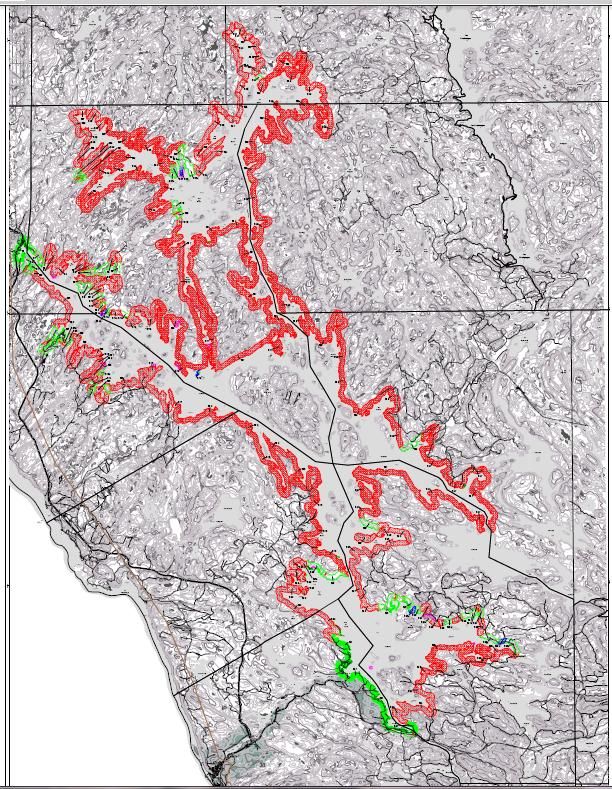
Lake Kipawa watershed
Areas of wildlife interest

Lake Kipawa

River

Town and villages

                             Figure 1: Location of Lake Kipawa Watershed

                                                                           8
2.2 Land Allocation and Use
2.2.1 Land Allocation
The municipalities of Béarn, Laniel, Kipawa and Témiscaming extend around the lake. The
unorganised territory of Les Lacs-du-Témiscamingue includes the eastern part of the lake. The
communities of Eagle Village First Nation and Wolf Lake First Nation represent the resident
Aboriginal population of the lake, and they live in the neighbourhood of Témiscaming and
Kipawa. See Figure 2: Administrative Divisions on Lake Kipawa.
It is to be noted that in addition to the year-round resident population in the immediate
neighbourhood, there is an important summer population and visitors that are difficult to
quantify (no existing data).
Most of the area is public land, and private lots accounts for 3.4 km² enclaved around the lake:
around the municipalities of Laniel and Kipawa, but also at the Red Pine Chute and scattered
lots here and there.
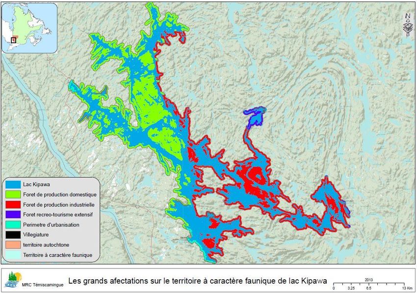
Outside of the inhabited areas, most of the land is forest used for wood production (stove wood
for domestic use or industrial processing). See Figure 3: Main Land Allocations in the Area of
Wildlife Interest on Lake Kipawa.
The Opémican National Pak will be implemented northwest of the lake. Most of the territory is
located along the Ottawa River and a smaller part extends on the shores of Lake Kipawa. The
territory outlined on the map (draft) is subject to changes that were not available at the time of
writing this report. McKenzie Island and Pointe du Rocher au Corbeau, for example, have been
withdrawn from the initial park project; they will become biodiversity reserves, so hunting will
be allowed in them.
The Opémican Regional Park is located within the territory limits. It covers an area of 6.5 square
kilometres and it was made official in 2000. It was implemented by the MRC de Témiscamingue,
essentially to develop recreational activities around the Opémican Point where buildings that
are part of site classified as cultural property in 1983 are found. This is a former operation
facility for log driving. On March 21, 2013, the Québec government announced the creation of
the Opémican National Park on a large tract of land including the Regional Park, which made the
latter’s status obsolete.
Nine (9) biological refuges: mature or overmature forests representative of Québec’s forest
heritage are found around the lake. Figure 4 shows the different locations of these protected
areas.
2.2.2 Land Use
- Three (3) controlled harvesting zones (ZECs) are found not far from the lake, but do not
overlap the area of wildlife interest (Kipawa, Restigo, Maganasipi)
- The Beauchêne outfitting operation, with exclusive rights, is located south of the lake
without touching it.
- Twenty-one (21) outfitters were present in 2013 on the shores of Lake Kipawa, including
126 camps (FPQ, 2013). The whole Témiscamingue region accounts for a total of 52
outfitting operations (Bonjourquebec.com)
- 25 registered traplines are distributed around Lake Kipawa
- 14 shelters (hunting camps) within the perimeter of the area of wildlife interest
- 462 cottages currently around the lake including 84 on rented public land, 359 on
private land and 19 occupants without permit or title.
9Municipal limits
Areas of wildlife interest
Lake Kipawa
Town and villages
Figure 2: Administrative Divisions on Lake Kipawa
10Lake Kipawa
Domestic production forest
Industrial production forest
Extensive recreotourism
Urban area
Vacationing
Aboriginal territory
Area of wildlife interest
Figure 3: Main Land Allocations in the Area of Wildlife Interest on Lake Kipawa
11Opemican National Park
Opemican Regional Park
Controlled Harvesting Zone (ZEC)
Biological refuges
Outfitter with exclusive rights
Municipal limits
Area of wildlife interest
Lake Kipawa
Towns & villages
Figure 4: Protected Areas around Lake Kipawa
12319 cottages are found on Laniel’s territory and the unorganised territory of Les Lacs-
du-Témiscamingue, 8 within the municipal limits of Béarn, 10 in Témiscaming and 126 in
Kipawa.
- 241 residences are located on private lots, 1 on leased public land and 1 occupant
without permit or title: 77 on Laniel’s territory and the unorganised territory of Les Lacs-
du-Témiscamingue, 32 in Témiscaming and 134 in Kipawa (MRN, 2010; MRC, 2013).
- 112 vacant lots intended for all types of uses are located around the lake (for building,
exploitation, other activities such as public access, electrical control facilities, etc.).
These lots have been surveyed before the moratorium and their development for
vacationing and outfitting purposes was frozen by the MRN. Should the moratorium be
lifted, they should not all be considered as constructible (MRCT, 2013).
All this information is visually represented in Figure 5: Distribution of owners, lessees and
occupants without permit or title on Lake Kipawa.
The lake was used in the past for log driving.
The industrial and service sectors are served by:
- 1 lease for helicopter landing (Laniel)
- 1 lease for parking purposes
- 8 surface mineral substances sites: gravel pits, sand pits, etc. (abandoned, planned or in
operation)
- Mining claims in the central and southeast area (52.3 km²)
Mining exploration projects
Concerning the area’s mining potential, Pierre Doucet, a geologist with the Ministry of Natural
Resources, provided the following information (personal communication):
- The Zeus project, held by Matamec Explorations, is by far the most advanced; feasibility
and impact studies are underway. The preliminary study suggests an open-pit operation
of 5072 t of rare earth oxide concentrate per year, over 12.9 years and the beginning of
production in the second quarter of 2016. This implementation scenario remains to be
confirmed.
- The Lake Sairs project, owned by Fieldex Exploration, is located a few kilometres
southeast of the Matamec ore body.
- The Turner Falls project, held by Les Entreprises minières Globex, is located north of the
Zeus project.
- The Kipawa West project, held by Mines Aurizon and Forum Uranium Corporation, is
located northeast of the Matamec property.
Other projects, such as that of Hinterland Metals, located 30 km west of the Matamec project,
are at the stage of very preliminary exploration work.
Other companies and individuals hold claims in the surroundings of these projects, but there is
no additional information available.
13Owners
Lessees
Occupancy w/o permit/title
Municipal limits
Lake Kipawa
Figure 5: Distribution of owners, lessees and occupants without permit or title on Lake Kipawa
142.2.3 Zoning of the Riparian Buffer Strip
A zoning of the riparian strips was done by the MRN (Patrick Raymond and Daniel Riopel,
September 1988, validated in August 2004), but only around Lake Kipawa as such (not on the
whole area of wildlife interest). The satellite lakes are not included in the zoning; special
attention must be paid to the map to see the sampled perimeter, which is different from the
area of wildlife interest.
Carried out in compliance with the standards described in the Guide de développement de la
villégiature sur les terres du domaine public (guide to cottage development on public land) and
the PRDTP (regional public land development plan), the lake zoning is a development plan for
recreational and tourism purposes for the benefit of the general public. Concretely in the field,
the work consisted in assessing the lakeshores’ potential by measuring different parameters
such as slope, type of soil and vegetation.
For the inventoried area, the preliminary results, which may still be refined in the field, suggest
that 88.11% (in red on the map) of the riparian zone is dedicated to conservation. The rest of
the territory may potentially be developed (but no development planned for the time being):
12.6 km² (88.25 km of shoreline, in green on the map) where conditions theoretically allow for
constructions (for the land is not too rugged or sloped) and 0.44 km² can be used for public
access.
Important note: this potentially manageable linear area is not necessarily intended for
constructions or development; the fieldwork simply allowed identifying the favourable zones.
Sectors with a recreational and tourism potential were also identified. The percentages are not
related to the area of wildlife interest, but they are rather proportions of the territory
inventoried through the fieldwork. This information is presented in Figure 6: Zoning of the
Riparian Buffer Strip (source: MRN, 2004).
2.3 Public Infrastructures
- Lake Kipawa has two (2) managed public accesses, the municipal dock located in Laniel
and that of Kipawa. In addition to these two accesses, 4 other public launching ramps
are known. In the past few years, bush roads built for forest operations have allowed a
number of cottagers to access their site. Therefore, certain water accesses are unknown
and not inventoried.
- 1 lease for a lookout
- 1 lease for a holiday camp
- 1 lease for a rest area
- 1 lease for a managed camping ground
- 3 leases for picnic grounds
- 1 lease for an entrance kiosk (MRN, 2010, 2013).
2.4 Recreation and Tourism Services and Companies
Tourism related to wildlife and generally to outdoor activities is very important on Lake Kipawa.
A building used for community activities and holiday camp is found on the lake. Sites are
available to all for recreational, sports or educational activities for non-profit community use, for
example, basic camping facilities on Laniel’s territory.
15Area of riparian corridor = 151.91 km2
Conservation = 133.85 km2 – 88.11%
(Minimum 25% of total riparian corridor)
Area suitable for development =
(Suitable + public land + public access) 18.06 km2 – 12%
Suitable for development: 18.06 km2 – 12%
(Suitable for development + private land + leased land) =
Maximum 60% of riparian corridor area
Private land – 4.92 km2 – 3.24%
(Suitable for development + private land + leased land) =
Maximum 60% of riparian corridor area
Public access - 0.44 km2 – 2.44%
Minimum 15% of zone suitable for development
Recreation/tourism potential Figure 6: Zoning of the Riparian Buffer Strip
Source: MRN, 2004
16Services
Different routes allow practicing outdoor activities at Lake Kipawa; the sections in the area of
wildlife interest are the following:
- Route verte (Green Road) (3 km), for cycling
- Snowmobile trails (4,3 km)
- Quad trails (9,4 km)
- Cross-country ski trails (1,8 km)
- A stretch of 120 km of canoe-kayak route crosses a number of lakes − McLachlin,
Grindstone, Bedout, Audoin and Hunter’s Point. This route is recognised by the
Fédération québécoise du canot et du kayak (FQCK) and features landscapes qualified as
pleasant. Lake Kipawa is identified as a potential site for sea kayak.
Companies
- Houseboat rental
Houseboats can be rented at Lake Kipawa.
- Algonquin Canoe Company
This company has a network of portages, trails and camping sites and offers boat rental
and guided tours services (Web page, July 2013).
- The services offered by outfitters (total of 21 whose activity is not always known) at
Lake Kipawa allow enjoying hunting and fishing as well as escaping to the wilds.
- Surf On School
This company offers wakeboard, wakeskate, wakesurf courses and guided tours on Lake
Kipawa.
2.5 Throughput
Land use for recreation/tourist activities (boating, canoeing, hunting and fishing, in outfitting
camps or not, etc.) and the residents around the lake represent the throughput of the water
body.
Data on anglers throughput are summarised in the table below.
YEAR
1975 1982-1984 1989 1994 1999 2006
Number of rod
28,600 39,043 64,697 38,851 31,692 36,411
days
ORIGIN % % % % % %
Québec 10.6 24.8 32.5 33 31 30
Ontario 26.4 40.1 41.7 38 30 36
USA 63.0 35.1 25.8 29 39 34
TYPE OF STAY % % % % % %
17YEAR
1975 1982-1984 1989 1994 1999 2006
Outfitter 78.0 72.1 60.0 58 63 48
Cottage 14.0 17.0 22.3 26 18 36
Camping 8.0 6.1 3.8 7 2 3
Day-by-day
-- 4.8 12.9 7 5 5
fishing
Houseboat -- N/A N/A 2 12 4
Table1: Anglers Throughput on Lake Kipawa from 1975 to 2006 (source: Nadeau, D., Trudeau, C., 2012)
An estimate of the lake’s total throughput for all types of uses would have been interesting, but
the information does not exist on that scale. However, the outfitters’ accommodation capacity
gives a good indication of the throughput: it is 706 guests per day (FPQ, 2013, personal
communication), to which we must add many other occasional visitors.
To have a idea (unofficial data), we could extrapolate the following: on Lake Kipawa in 1999,
there were 31,692 rod days; in 2000, there were 1,254,270 rod days spent in Abitibi-
Témiscamingue (MRN, 2000; Fisheries and Oceans Canada, 2003). Lake Kipawa therefore
accounts for approximately 2.5% of the fishing activity at the regional level.
According to FAPAQ, this is the most important public water body for sports fishing in the
region; it would represent a good potential for wildlife development (FAPAQ, 2002).
2.6 Existing Regulatory and Planning Tools
2.6.1 Regulatory Tools
Different regulatory tools already exist to allow regulating activities on Lake Kipawa; however,
the extent of their enforcement and compliance are not known:
The MRN’s PRDTP, recreation/tourism section, provides guidelines and objectives for
cottage development on Abitibi-Témiscamingue’s public land. This plan indicates that
Lake Kipawa is a wildlife territory where cottage development will eventually be
permitted but only with a concerted development plan.
The PATP provides guidelines for the interventions of the various actors and defines the
government’s policy directions for public land use and protection (MRN, 2013, online).
Fishing regulations: a regulatory change in the lake trout and walleye fishing period was
adopted, but the anticipated effect was not achieved. The opening period for lake trout
is now from the 4th Friday of April to Monday, September 15 or the nearest for the
whole province. As for walleye fishing, it is closed from April 1 to the third Friday of May
(during spawning season).
18Discussions on lake trout size limits, catch and possession limits, catch-and-release and ice
fishing are underway (A. Fort, personal communication).
Sustenance fishing practiced by First Nations is not subject to these regulations.
There exists a regulation on water protection against leisure craft waste in the
Environment Quality Act, particularly Chapter Q-2. It provides for heavy penalties in case
of non compliance (Éditeur officiel du Québec, 2013)
A municipal bylaw also applies, based on the MRCT’s development plan, within the
limits of Kipawa, Témiscaming, Béarn, Laniel and the unorganised territory of Les Lacs-
du-Témiscamingue; its enforcement is under the municipalities’ responsibility (D.
Dufault, MRCT, personal communication):
- Minimum lot size
To be constructible, lots located within 300 metres from the lake must be 50 metre wide, 60
to 75 metre long and have a minimal surface area of 4000 square metres. However, any lot
of smaller size and described in a contract prior to 1984, may still be constructible,
considering it has an acquired right.
- Forest cuts
A visual and forested buffer zone applies from the shore of Lake Kipawa. This buffer
corresponds to the visible landscape based on topography, up to a distance of 1.5
kilometres. Clear cuts are forbidden in the visual buffer zone, but partial cuts are allowed.
- Banks and littoral protection
Provincial regulations, i.e. the Policy for the protection of riverbanks, littoral zones and
floodplains, apply. The bank corresponds to a protective strip of 10 to 15 metres around
the lake. To sum it up, it must remain in its natural state. Municipalities are mandated to
enforce these regulations. In Laniel, boathouses are subject to special roofing criteria (look
and harmonisation with the environment). As for docks, only floating, pillared or piled
docks are allowed.
- Septic system
Cottages and residences bordering the lake must be connected to a personal septic system.
In case of environmental pollution by septic spill, the municipality may require the owner to
upgrade his septic system to standards.
As for outfitting facilities, they must be connected to a commercial system that is monitored
by MDDEFP. Only a certified professional can determine the type of septic system based on
soil characteristics.
- Restriction to boating
In Dorval, MacAdam and Canal bays, near the heron colony, Clermont and Huard islands,
speed is limited to 10 km/h within 30 metres from the shore.
19The municipality of Laniel also has special directives mainly aimed at ensuring a year-round
residential development on its land. See Appendix 2: Main Regulations in Laniel for Residential
Development around Lake Kipawa.
2.6.2 Planning Tools
Concerning vacation site development, we can refer to the “guide to cottage development on
public land” (MRN, 1994). The guide distinguishes between private, commercial and community
vacation sites as well as between dispersed and grouped development or between permanent
and temporary vacationing sites. Finally, a distinction is made between waterfront and inland
vacation sites (proximity to a lake or river). Different modalities apply to these different
categories. Furthermore, the guide mentions that pursuant to the regulations on land zoning on
sites intended for waterfront vacation sites, islands less than 10 hectares are excluded from any
land subdivision projects for vacationing purposes. These islands are included in the
conservation area. Islands of 10 hectares or over can support cottage development, but under
certain conditions.
The MRC de Témiscamingue initiated a pilot project, called Forêt De Chez Nous, to develop
forest resources in Témiscamingue’s local forest. This project was submitted to MRN under the
Sustainable Forest Management Act on August 23, 2010. Certain portions could cover the shores
of Lake Kipawa.
Approximately 77 % of the public section of the area is targeted for forest management up to
2018 as shown in Figure 7: Land Assignment for Forest Management Purposes, but discussions
and public consultations are still necessary. More specific areas have been targeted for potential
silvicultural development in the coming years, and this is also at the discussion stage: see Figure
8: Potential Logging Areas up to 2018.
2.7 Lake Kipawa Water Quality and Level
2.7.1 Water Quality
Various data on water quality are available for Lake Kipawa, but none focused particularly on
this issue for now.
Lake Kipawa’s water is generally of good quality and is used as drinking water by the Aboriginal
community of Eagle Village, among others (MRN, 2012). However, a decrease in water quality is
observed with the presence of blue-green algae officially reported near Kipawa (MDDEFP, 2012).
Yet, Lake Kipawa is qualified as oligotrophic, i.e. normally poor in nutrients as shown by the
composition of the phytoplankton community (Moreau, C., 2005). Water is even qualified as
pure and the study area was pollution free (Edwards Pass). There seemed to be no problem with
water quality in 1999, transparency was high (approx. 7 metres in certain sectors), pH slightly
acidic (6.4), and dissolved oxygen seemed adequate even in depth. Conductivity is about 20
µmhos (MRN, 2012) and dissolved salts are limited (Lamontagne, 1981). In the past years, many
riparian owners deplored the decrease in water quality (personal communication). However,
there exists no study on phosphorus concentration. Studies were carried out by MDDEFP
20Off-contract area
Under-contract area
Off-inventory area
Lake Kipawa
Towns and villages
Figure 7: Land Assignment for Forest Management Purposes
21Potential forest cuts
Area of wildlife interest
Lake Kipawa
Town and villages
Figure 8: Potential Logging Areas up to 2018
22(MDDEFP, 2013 and Denis Laliberté, personal communication) on the accumulation of toxic
compounds in fish flesh in Lake Kipawa (southwest of Crow Island, McLaren Bay, Lake Bedout).
In 2010 and 2011, the mean mercury content exceeded MDDEFP’s directive of 0.5 mg/kg for
lake trout and yellow walleye. In lake trout, content was slightly higher than the median content
for the whole province and similar to the median content in yellow walleye.
Based on these concentrations, recommendations are made for consumption of these species
based on fish size (for example, it is recommended to eat a maximum of 4 walleyes 30-40 cm
long per month with this level of mercury content).
The mean arsenic content in lake trout is slightly higher than that of the Chibougamau area
(region of reference for metals). The mean content for other metals in lake trout and yellow
walleye is approximately the same as in that region.
In 2011, the mean content in PCB, PBDE (polybrominated diphenyl ether) and toxics equivalent
to 2,3,7,8-TCDD in lake trout (1.1 ng/kg) are considered as low.
A pilot project carried out by the OBVT in the municipality of Kipawa (Baie-de-Kipawa Road and
Miwapanee Road, 2012) showed that 60% of the observed septic systems (on a total of 37
systems for 260 waterfront cottages and residences) are in a worrying state or are a source of
direct contamination. In this same study, it was determined that the state of the riparian strip of
more than 60% of visited residences was composed of less than 40% of natural vegetation and
was therefore generally in poor condition.
A lot of work remains to be done to determine whether all cottages and residences have septic
systems and whether these systems are in good operating condition. Riparian strips should also
be monitored.
The municipality of Laniel has the only pumping station in operation for Lake Kipawa, which is an
interesting service and rarely offered in Québec. Located at the municipal dock, it costs $ 30 per
boat wastewater disposal.
2.7.2 Water Levels
The dams of the Kipawa reservoir are operated by the Centre d’expertise hydrique du Québec
(CEHQ). CEHQ is an agency of the Ministry of Sustainable Development, Environment, Wildlife
and Parks. Furthermore, given the complexity of the Ottawa River watershed and the numerous
operators, the river is managed in an integrated way through the Ottawa River Regulation
Planning Board (ORRPB), made up of representatives from the Canadian, Ontario and Québec
governments. The Commission’s mandate is to establish the general principles, priorities and
policies for the main reservoirs in the watershed and to implement them. A secretariat was also
formed and it constitutes the Commission’s executive arm as well as the Coordination Centre for
issues concerning the management of the Ottawa River Basin. The operational arm of the Board
is the Ottawa River Regulating Committee (ORRC). The Committee members are employees of
the Canadian, Québec and Ontario governments, Ontario Power Generation and Hydro-Québec.
The Committee is responsible for the operation of the reservoirs while respecting the general
policies established by the Board (A. Bilodeau, personal communication).
23The annual drawdown (difference in water level) is approximately 2 metres. This is a very
delicate situation as it involves various conflicting interests: water level management for the
whole Ottawa River watershed, lake trout spawning, water level for boats and docks, shoreline
erosion. Table 2 below shows a summary of requirements.
Requirement
Dam managers Lake trout Boat - docks
Spring Low level in early spring, Mean level Mean level
then raising the level to
absorb spring flood
Summer Mean level Mean level Mean level
Fall Raising the level to have Low level to avoid No lowering of level to
reserves for winter spawning in areas to be allow boats to go out
later uncovered and (optimal navigation
possible raise of level after level: 269.5 m)
fish eggs have been laid
Winter Lowering the level for No lowering of level below N.A.
hydroelectric supply and the elevation reached
in anticipation of spring during spawning
flood
Table 2: Summary of Requirements for Lake Kipawa Water Level
A general summary of CEHQ’s water management is presented in Table 3 below (Andrée
Bilodeau, CEHQ, 2013):
Management information
GENERAL
- The Kipawa reservoir management objectives are to provide protection against flooding,
maintain water level for recreation and regulate water for hydro-energy production.
- The Kipawa reservoir is one of the main reservoirs of the Ottawa River Basin and is the subject
of integrated management by the Ottawa River Regulation Planning Board
(http://rivieredesoutaouais.ca).
- The water levels of the Kipawa reservoir and flows of the Kipawa River and Gordon Creek are
available on the CEHQ website http://www.cehq.gouv.qc.ca.
W INTER
- During winter, the reservoir is emptied gradually in anticipation of spring flooding. This
drawdown ensures the safety of people upstream and downstream of the dam and also allows
to regulate water for hydro-electric energy production.
SPRING
- In the spring, we gradually reach the level of 269,50 m for the start of summer season while
minimizing downstream flooding.
SUMMER
- During the summer season, we maintain the water level between 269,50 m and 269,55 m.
24Management information
During flood periods, we aim to stabilize the water level between 269,50 m and 269,75 m.
FALL
- In the fall, the Lake level may drop below 269,50 m which allows greater flexibility in the
management of fall rain events. In early December, before the drawdown, the target levels is
around 269,50 m.
Table 3: General Information on Water Level Management in Lake Kipawa (CEHQ, 2013)
The summary of levels reached during the year was produced by the CEHQ; levels were
relatively constant throughout the years:
Level Data Comments
Drawdown target: 267,60 m Drawdown level reached an average before the
start of the freshet.
Minimum summer operation 269,50 m
level:
Summer operation level: Between 269,50
m and 269,55 m
Maximum operatio level: 269,75 m Maximum water level target during freshet.
Discharge –Kipawa River Data Comments
3
Minimum discharge: 15 m /s Aquatic habitat constraint.
3
Minor flooding threshold: 300 m /s At this flow, a field and a garage belonging to a
local resident are affected.
Discharge –Gordon Creek Data Comments
3
Minimum discharge: 10 m /s The gates of the Kipawa dam are left at a constant
opening to provide this flow.
3
Minor flooding threshold: 28 m /s Minor flooding threshold in the municipality of
Kipawa.
Table 4: Summary of Water Levels Controlled by CEHQ at Lake Kipawa (CEHQ, 2013)
The optimal navigation elevation is 269.5 metres; below that level, docks are no longer in
optimal operating condition.
Negotiations are underway between MRN and dam managers to reach an agreement; tests
could be made in fall 2013. The level reached during lake trout spawning would be 40 cm lower
that the one reached to this day. This would prevent fish from laying their eggs too high on the
banks (sites that are then uncovered in winter, which causes egg loss by freezing). This situation
should be monitored to determine the extent to which this change in fall drawdown helps fish
reproduction.
252.8 Habitats to be Protected and Sites of Interest
2.8.1 Forest Habitats
An exceptional forest (Lake Kipawa’s ancient forest, Hemlock-yellow birch forest) is adjoining
Lake Kipawa to the south, at the Latour Bay level.
A descriptive sheet of the PATP (public land use plan) was produced for the proposed
exceptional forest ecosystems of Abitibi-Témiscamingue (zone No. 08-009). Twenty-nine (29)
sites are found across the region for a total of 18.7 km² and a sector of Turtle Island on Lake
Kipawa is part it. The objective is the total protection of these exceptional environments.
Islands less than 250 ha are automatically excluded from timber allocations. The largest ones are
also excluded for now, essentially for operational reasons. However, these potential logging
areas remain part of the Forest Management Units; they could therefore be harvested should
the strategies change.
2.8.2 Sites of Wildlife Interest
Particularly sensitive zones are to be excluded from the zoning plan (MRN, 2013):
- Spawning grounds (lake trout, yellow walleye, northern pike); details are provided in
section 2.10 State of Faunal Populations;
- Prey birds (3 bald eagle nests and 1 peregrine falcon nest).
Concerning the bald eagle, a 700-metre protection zone ensures the nest’s protection (integral
300 metre protection zone and 400 metre buffer zone).
No forest management activity is allowed within the integral protection zone. Activities are
allowed in the buffer zone from September 1 to March 15, i.e. outside the species’ nesting
period. However, these activities must exclude the construction of permanent infrastructures
(roads, buildings, etc.).
As for the peregrine falcon, a species at risk, an integral protection zone of 250 metres on each
side of the nest on the whole height of the rock wall or escarpment and a 50-metre strip from
the limit of the slope break up and down the rock wall or escarpment must be respected.
Additionally, there is a 100-metre buffer zone surrounding the integral protection zone. No
forest management activity is allowed within the integral protection zone.
Activities are allowed in the buffer zone from September 1 to the end of February, i.e. outside
the species’ nesting period.
- A heron colony on Lake Kipawa is also legally protected (MDDEP, 2012) to ensure the
sustainability of this breeding site. It is also listed in a PATP descriptive sheet, zone No. 08-
011 among 29 other sites in the region.
It is mentioned that the wildlife habitats present an interest for bird watching and that they
must be respected.
2.8.3 Peatland
The PATP description mentions 2 km² of peatland in zone 08-048, representing 0.3% of its
surface area. The exact location is not mentioned and this figure is an indication only.
262.8.4 Sites of Archaeological Interest
According to MRN, the zone has an archaeological potential (7 known archaeological sites), but
we have no information on the location, surface area or the type of archaeological artefacts.
2.8.5 Cultural Sites
An Aboriginal burial site and a church are found in Hunter’s Point. To this day, we obtained no
information on the existence of other cultural sites.
2.8.6 Beaches
Many beaches of different sizes are found around the lake, but they have never been accurately
mapped. So we do not know about their condition and accommodation potential.
2.9 State of Plant Populations
Lake Kipawa belongs to the Southern Laurentians natural region, bioclimatic domain of the
sugar maple-yellow birch forest (MDDEFP, 2011).
A complete description of vascular plants was done as part of an inventory done for the
proposed Opémican National Park (MDDEFP, 2011).
We will mention only the floristic elements of interest to the extent that they represent issues
for the Management Plan and can be located on the lake’s wildlife territory. A total of 10 species
likely to be declared endangered or threatened have been inventoried.
LATIN NAME ENGLISH NAME
Arethusa bulbosa Dragon's mouth
Astragalus australis Indian milkvetch
Boechera retrofracta Reflexed rockcress
Ceanothus herbaceus Prairie redroot
Elaeagnus commutata Wolf-willow
Gratiola aurea Golden hedge-hyssop
Lathyrus ochroleucus Cream-coloured vetchling
Platanthera blephariglottis var. White fringed orchid
blephariglottis
Polygonella articulata Northern jointweed
Utricularia geminiscapa Hidden-fruit bladderwort
Table 5: Floristic Species Likely to be Declared Endangered or Threatened in the Opémican National Park (Source:
Dignard, 2010)
272.10 State of Faunal Populations
2.10.1 Birds
Species needing protection nest in the lake area: peregrine falcon, bald eagle and great blue
heron (see paragraph 2.8.2 in the Sites of Wildlife Interest section).
An inventory was carried out as part of the Atlas des oiseaux nicheurs du Québec (Quebec
nesting birds atlas) in the surroundings of the municipality of Kipawa: common nighthawk1,
chimney swift1, olive-sided flycatcher1 and rusty blackbird2 have the following status: 1- Likely to
be declared in Québec, Endangered in Canada; 2- Likely to be declared in Québec and Special
concern in Canada (Sylvain Giguère, Environment Canada, personal communication).
2.10.2 Amphibians and Reptiles
Prospection work was carried out in search of herpetofaunal species (Environment Canada,
2010) on the Algonquins’ ancestral land with Louis-Philippe Dénommé. Potential sites for
Blanding’s turtle and wood turtle were identified, but no individuals were observed.
Painted turtles and snapping turtles were seen or captured as well as many amphibians. None of
these has a protection status except for the snapping turtle that has a Special concern status
across Canada. For certain species, the geographical location represents the limit of the species
range.
2.10.3 Fish Populations
The most interesting species for sports fishing are lake trout, yellow walleye and northern pike.
Many pike spawning grounds were identified by the MRN in the shallow waters of the islands.
Other species are also present: lake herring, lake whitefish, perch, sucker, common catfish,
smallmouth bass and burbot (MRN, personal communication). Lamontagne mentioned 18
species from 9 families. The latter are important as forage species, but also for fishing to a lesser
extent. In the early 20th century, commercial fishing was practiced on Lake Kipawa, mainly for
yellow walleye and whitefish (Lamontagne, 1981).
We have good knowledge on Lake Kipawa’s fish populations for it is part of the provincial lake
monitoring network.
For information, a theoretical optimal harvest was assessed in 1975 (Lamontagne, 1981): 33,963
kg (Rounsefell formula) or 44,615 kg (Ryder formula) for the whole lake. Even though no longer
valid today, these figures remind us that there exists a limit below which fish populations cannot
reproduce naturally.
A problem raised is the barotrauma phenomenon: Literature reports that the impact of rod
fishing on fish survival may be significant due to barotrauma. This phenomenon occurs mainly
when fish are pulled from deep water and brought very quickly to the surface; swim bladders
are squeezed and this compromises their survival in case of release (Faculty of fishing, 2013).
Public education needs to be done, but injuries caused by fishing hooks are certainly more
damageable (A. Fort, personal communication).
2.10.4 Lake Trout Situation
Lake trout is a salmonid broadly distributed in North America. It particularly enjoys cold (10°C),
clear and well oxygenated water (MRNF, 2012).
In Lake Kipawa, lake trout has long been part of the most appreciated species for sports fishing.
But fishing and all the demographic factors related to the species (late sexual maturity,
28reproduction on shores subject to drawdown, etc.) have made the populations more fragile. Its
popularity was such that the species was designated as overharvested in its whole range in the
1980’s.
Year 1982- 1989 1994 1999 2006 2009 2010 2011 2012
84
Number of lake
trout harvested 12,6001 26,3001 51001 28001 10181 1758² 1991² 1683² 2070²
1
Table 6: Lake Trout Harvested in Lake Kipawa ( : MRN, 2012 total sports fishing. ²: MRN, 2013, personal
communication, represents only lake trout harvested in outfitting operations)
Source 1 is the estimated harvest by total sports fishing while source 2 represents only the lake
trout fishing in outfitting operations.
The situation remains a concern and harvesting must be controlled and reasonable.
Other factors such as changes in the fish community or the habitat are also affecting lake trout.
The most recent estimates for Lake Kipawa show that the number of sampled adults is low, but
the immature individuals are well represented (following stocking): the situation should improve
in the coming years when immature individuals reproduce, provided that the eggs are not
affected by drawdown (Nadeau, D., 2008).
Stocking programs were carried out in 1992: 37,500 fry or 34% of the stock, 94: 33,500 or 37%,
96: 14,000 or 12% and 98: 42,300 or 50% (MRNF, 2012). The success of these campaigns will
ideally be known in the coming years. The MRN is considering a new recovery plan, possibly this
time with fish from outside the lake (A. Fort, personal communication).
2.10.5 Yellow Walleye Situation
Yellow walleye is part of the second group of most popular fish for sports fishing after the
salmonid group.
Nadeau and Trudeau (2012) reported that the different catch size adjustment measures (> to 32
cm after 1999) and a good population recruitment allow the latter to be still abundant today.
The reproductive potential seems to be sufficient to ensure the stock’s self-perpetuation.
However, in recent inventories, a majority of fish were small size. Harvesting is responsible for a
50% mortality rate, which is clearly higher than the allowable maximum under these latitudes
(38%).
Recruitment is ensured only by a limited number of spawners, which makes the stock vulnerable
in case of disturbance (poor climate conditions, low larvae survival rate, for example). According
to the authors, the current harvesting rate seems too high.
3. Individual Concerns
Two means allowed the public and stakeholders to express their concerns regarding the
proposed development of Lake Kipawa:
- Consultation workshops during the public information meeting (approximately 100
participants)
- Online survey (Appendix 3), 140 respondents
29You can also read